Bridge Statistics for Lakeside, California (CA)
Condition, Traffic, Stress, Structural Evaluation, Project Costs
- National Bridge Inventory (NBI) Statistics
- 23Number of bridges
- 312ft / 95.3mTotal length
- 489,815Total average daily traffic
- 22,952Total average daily truck traffic
- National Bridge Inventory (NBI) Registered Bridges for Lakeside
- No street view available for this location
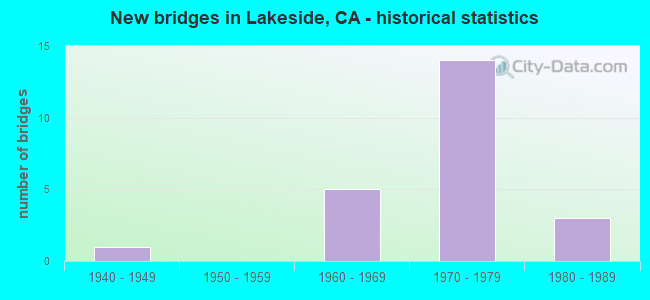
- New bridges - historical statistics
- 11940-1949
- 51960-1969
- 141970-1979
- 31980-1989


- Bridge Condition - Deck
- 66.7%Good
- 33.3%Fair

- Bridge Condition - Superstructure
- 91.7%Good
- 8.3%Fair

- Bridge Condition - Substructure
- 91.7%Good
- 8.3%Fair

- Bridge Condition - Channel
- 44.4%Very good
- 33.3%Good
- 11.1%Satisfactory
- 11.1%Fair
Find on map >> Show street view
Structure Number: 57 0462L, Location: 11-SD-008-R21.82 (Lat: 32.844567, Lng: -116.881958), Route carried "on" structure: Interstate 8, Year Built: 1965, Status: Open, Structure Length: 4.42m (14.50ft), Average Daily Traffic: 27,500 (year 2012), Truck Traffic: 7%, Average Future Daily Traffic: 49,656 (year 2036), Design Load: HS 20, Features Intersected: LAKE JENNINGS PARK RD
Minimum Vertical Clearance: 30+ m (98+ ft), Kilometerpoint: 21.820, Lanes on structure: 3, Lanes under structure: 2, Base Highway Network: Yes (, Subroute: 1), Owner: State Highway Agency, Approaching Roadway Width: 13.7m (44.9ft), Material/Design: Concrete continuous, Design/Construction: Tee Beam, Number Of Spans In Main Unit: 3, Length of Maximum Span: 24.4m (80.1ft), Curb-To-Curb Width: 15.6m (51.2ft), Out-to-Out Width: 16.2m (53.1ft)
Condition: Deck: Good, Superstructure: Good, Substructure: Good, Operating Rating: 63.5 metric tons, Method Used To Determine Operating Rating: Load Factor (LF), Inventory Rating: 38.2 metric tons, Method Used To Determine Inventory Rating: Load Factor (LF), Structural Evaluation: Better than present minimum criteria, Deck Geometry: Somewhat better than minimum adequacy, Underclear: Meets minimum limits, Approach Roadway Alignment: Equal to present desirable criteria, Designated Inspection Frequency: Every 48 months, Inspection Date: May 2018, Deck Structure Type: Concrete Cast-file-Place, Wearing Surface/Protective System: Wearing Surface: Bituminous
Find on map >> Show street view
Structure Number: 57 0462R, Location: 11-SD-008-R21.82 (Lat: 32.844269, Lng: -116.881803), Route carried "on" structure: Interstate 8, Year Built: 1965, Status: Open, Structure Length: 4.42m (14.50ft), Average Daily Traffic: 27,500 (year 2012), Truck Traffic: 7%, Average Future Daily Traffic: 49,656 (year 2036), Design Load: HS 20, Features Intersected: LAKE JENNINGS PARK RD
Minimum Vertical Clearance: 30+ m (98+ ft), Kilometerpoint: 21.820, Lanes on structure: 3, Lanes under structure: 2, Base Highway Network: Yes (, Subroute: 1), Owner: State Highway Agency, Approaching Roadway Width: 13.7m (44.9ft), Material/Design: Concrete continuous, Design/Construction: Tee Beam, Number Of Spans In Main Unit: 3, Length of Maximum Span: 24.4m (80.1ft), Curb or Sidewalk Widths: Left: 0.0m, Right: 0.6m (2.0ft), Curb-To-Curb Width: 14.3m (46.9ft), Out-to-Out Width: 14.9m (48.9ft)
Condition: Deck: Good, Superstructure: Good, Substructure: Good, Operating Rating: 63.5 metric tons, Method Used To Determine Operating Rating: Load Factor (LF), Inventory Rating: 38.2 metric tons, Method Used To Determine Inventory Rating: Load Factor (LF), Structural Evaluation: Better than present minimum criteria, Deck Geometry: Meets minimum limits, Underclear: Meets minimum limits, Approach Roadway Alignment: Equal to present desirable criteria, Designated Inspection Frequency: Every 48 months, Inspection Date: May 2018, Deck Structure Type: Concrete Cast-file-Place, Wearing Surface/Protective System: Wearing Surface: Bituminous
Find on map >> Show street view
Structure Number: 57 0559L, Location: 11-SD-067-R3.91 (Lat: 32.854889, Lng: -116.947314), Route carried "on" structure: State highway 67, Year Built: 1970, Status: Open, Structure Length: 4.88m (16.01ft), Average Daily Traffic: 27,500 (year 2020), Truck Traffic: 4%, Average Future Daily Traffic: 41,080 (year 2040), Design Load: HS 20, Features Intersected: RIVERFORD ROAD
Minimum Vertical Clearance: 30+ m (98+ ft), Kilometerpoint: 3.910, Lanes on structure: 2, Lanes under structure: 3, Base Highway Network: Yes (, Subroute: 1), Owner: State Highway Agency, Approaching Roadway Width: 12.5m (41.0ft), Skew: 1 degrees, Material/Design: Concrete continuous, Design/Construction: Box Beam or Girders - Multiple, Number Of Spans In Main Unit: 3, Length of Maximum Span: 22.9m (75.1ft), Curb-To-Curb Width: 11.9m (39.0ft), Out-to-Out Width: 12.5m (41.0ft)
Condition: Deck: Good, Superstructure: Good, Substructure: Good, Operating Rating: 38.6 metric tons, Method Used To Determine Operating Rating: Load and Resistance Factor Rating (LRFR) rating reported by rating factor(RF) method using HL-93 loadings, Inventory Rating: 29.8 metric tons, Method Used To Determine Inventory Rating: Load and Resistance Factor Rating (LRFR) rating reported by rating factor(RF) method using HL-93 loadings, Structural Evaluation: Better than present minimum criteria, Deck Geometry: Equal to present minimum criteria, Underclear: Equal to present minimum criteria, Approach Roadway Alignment: Better than present minimum criteria, Designated Inspection Frequency: Every 24 months, Inspection Date: September 2020, Deck Structure Type: Concrete Cast-file-Place
Find on map >> Show street view
Structure Number: 57 0559R, Location: 11-SD-067-R3.91 (Lat: 32.854656, Lng: -116.947153), Route carried "on" structure: State highway 67, Year Built: 1970, Status: Open, Structure Length: 4.33m (14.21ft), Average Daily Traffic: 27,500 (year 2020), Truck Traffic: 4%, Average Future Daily Traffic: 41,080 (year 2040), Design Load: HS 20, Features Intersected: RIVERFORD ROAD
Minimum Vertical Clearance: 30+ m (98+ ft), Kilometerpoint: 3.910, Lanes on structure: 2, Lanes under structure: 3, Base Highway Network: Yes (, Subroute: 1), Owner: State Highway Agency, Approaching Roadway Width: 12.5m (41.0ft), Skew: 1 degrees, Material/Design: Concrete continuous, Design/Construction: Box Beam or Girders - Multiple, Number Of Spans In Main Unit: 3, Length of Maximum Span: 22.9m (75.1ft), Curb-To-Curb Width: 11.9m (39.0ft), Out-to-Out Width: 12.5m (41.0ft)
Condition: Deck: Fair, Superstructure: Good, Substructure: Good, Operating Rating: 35.6 metric tons, Method Used To Determine Operating Rating: Load and Resistance Factor Rating (LRFR) rating reported by rating factor(RF) method using HL-93 loadings, Inventory Rating: 27.5 metric tons, Method Used To Determine Inventory Rating: Load and Resistance Factor Rating (LRFR) rating reported by rating factor(RF) method using HL-93 loadings, Structural Evaluation: Equal to present minimum criteria, Deck Geometry: Equal to present minimum criteria, Underclear: Equal to present minimum criteria, Approach Roadway Alignment: Better than present minimum criteria, Designated Inspection Frequency: Every 24 months, Inspection Date: September 2020, Deck Structure Type: Concrete Cast-file-Place
Find on map >> Show street view
Structure Number: 57 0560L, Location: 11-SD-067-R4.78 (Lat: 32.858042, Lng: -116.933047), Route carried "on" structure: State highway 67, Year Built: 1970, Status: Open, Structure Length: 3.23m (10.60ft), Average Daily Traffic: 25,500 (year 2020), Truck Traffic: 4%, Average Future Daily Traffic: 40,207 (year 2040), Design Load: HS 20, Features Intersected: LOS COCHES CREEK
Minimum Vertical Clearance: 30+ m (98+ ft), Kilometerpoint: 4.780, Lanes on structure: 2, Base Highway Network: Yes (, Subroute: 1), Owner: State Highway Agency, Approaching Roadway Width: 15.0m (49.2ft), Skew: 2 degrees, Material/Design: Concrete continuous, Design/Construction: Slab, Number Of Spans In Main Unit: 4, Length of Maximum Span: 9.1m (29.9ft), Curb-To-Curb Width: 15.0m (49.2ft), Out-to-Out Width: 15.6m (51.2ft)
Condition: Deck: Good, Superstructure: Good, Substructure: Good, Channel: Very good, Operating Rating: 67.4 metric tons, Method Used To Determine Operating Rating: Load Factor (LF), Inventory Rating: 40.5 metric tons, Method Used To Determine Inventory Rating: Load Factor (LF), Structural Evaluation: Better than present minimum criteria, Deck Geometry: Superior to present desirable criteria, Waterway Adequacy: Equal to present desirable criteria, Approach Roadway Alignment: Equal to present desirable criteria, Designated Inspection Frequency: Every 48 months, Inspection Date: September 2020, Deck Structure Type: Concrete Cast-file-Place
Find on map >> Show street view
Structure Number: 57 0560R, Location: 11-SD-067-R4.78 (Lat: 32.857822, Lng: -116.932814), Route carried "on" structure: State highway 67, Year Built: 1970, Status: Open, Structure Length: 3.23m (10.60ft), Average Daily Traffic: 25,500 (year 2020), Truck Traffic: 4%, Average Future Daily Traffic: 40,207 (year 2040), Design Load: HS 20, Features Intersected: LOS COCHES CREEK
Minimum Vertical Clearance: 30+ m (98+ ft), Kilometerpoint: 4.780, Lanes on structure: 2, Base Highway Network: Yes (, Subroute: 1), Owner: State Highway Agency, Approaching Roadway Width: 11.9m (39.0ft), Skew: 2 degrees, Material/Design: Concrete continuous, Design/Construction: Slab, Number Of Spans In Main Unit: 4, Length of Maximum Span: 9.1m (29.9ft), Curb-To-Curb Width: 11.9m (39.0ft), Out-to-Out Width: 12.5m (41.0ft)
Condition: Deck: Good, Superstructure: Good, Substructure: Good, Channel: Very good, Operating Rating: 67.4 metric tons, Method Used To Determine Operating Rating: Load Factor (LF), Inventory Rating: 40.5 metric tons, Method Used To Determine Inventory Rating: Load Factor (LF), Structural Evaluation: Better than present minimum criteria, Deck Geometry: Equal to present minimum criteria, Waterway Adequacy: Equal to present desirable criteria, Approach Roadway Alignment: Equal to present desirable criteria, Designated Inspection Frequency: Every 48 months, Inspection Date: September 2020, Deck Structure Type: Concrete Cast-file-Place
Find on map >> Show street view
Structure Number: 57 0561, Location: 11-SD-067-R4.83 (Lat: 32.858528, Lng: -116.932325), Route carried "on" structure: County highway S287, Year Built: 1970, Status: Open, Structure Length: 10.64m (34.91ft), Average Daily Traffic: 15,393 (year 2020), Truck Traffic: 2%, Average Future Daily Traffic: 24,648 (year 2042), Design Load: HS 20, Features Intersected: STATE ROUTE 67, Facility Carried by Structure: WINTER GARDENS BL
Minimum Vertical Clearance: 30+ m (98+ ft), Kilometerpoint: 0.000, Lanes on structure: 3, Lanes under structure: 5, Base Highway Network: Yes, Owner: State Highway Agency, Approaching Roadway Width: 13.0m (42.7ft), Material/Design: Concrete continuous, Design/Construction: Box Beam or Girders - Multiple, Number Of Spans In Main Unit: 5, Length of Maximum Span: 29.0m (95.1ft), Curb or Sidewalk Widths: Left: 0.0m, Right: 1.5m (4.9ft), Curb-To-Curb Width: 12.9m (42.3ft), Out-to-Out Width: 15.0m (49.2ft)
Condition: Deck: Fair, Superstructure: Good, Substructure: Good, Operating Rating: 45.4 metric tons, Method Used To Determine Operating Rating: Load and Resistance Factor Rating (LRFR) rating reported by rating factor(RF) method using HL-93 loadings, Inventory Rating: 35.0 metric tons, Method Used To Determine Inventory Rating: Load and Resistance Factor Rating (LRFR) rating reported by rating factor(RF) method using HL-93 loadings, Structural Evaluation: Better than present minimum criteria, Deck Geometry: Meets minimum limits, Underclear: Somewhat better than minimum adequacy, Approach Roadway Alignment: Equal to present desirable criteria, Designated Inspection Frequency: Every 24 months, Inspection Date: September 2020, Deck Structure Type: Concrete Cast-file-Place
Find on map >> Show street view
Structure Number: 57 0562L, Location: 11-SD-067-R5.19 (Lat: 32.860186, Lng: -116.926328), Route carried "on" structure: State highway 67, Year Built: 1970, Status: Open, Structure Length: 4.05m (13.29ft), Average Daily Traffic: 19,000 (year 2018), Truck Traffic: 7%, Average Future Daily Traffic: 31,682 (year 2040), Design Load: HS 20, Features Intersected: CHANNEL RD
Minimum Vertical Clearance: 30+ m (98+ ft), Kilometerpoint: 5.190, Lanes on structure: 2, Lanes under structure: 2, Base Highway Network: Yes (, Subroute: 1), Owner: State Highway Agency, Approaching Roadway Width: 11.9m (39.0ft), Skew: 1 degrees, Material/Design: Prestressed concrete, Design/Construction: Box Beam or Girders - Multiple, Number Of Spans In Main Unit: 1, Length of Maximum Span: 39.9m (130.9ft), Curb-To-Curb Width: 11.9m (39.0ft), Out-to-Out Width: 12.5m (41.0ft)
Condition: Deck: Fair, Superstructure: Good, Substructure: Good, Operating Rating: 51.8 metric tons, Method Used To Determine Operating Rating: Load and Resistance Factor Rating (LRFR) rating reported by rating factor(RF) method using HL-93 loadings, Inventory Rating: 34.7 metric tons, Method Used To Determine Inventory Rating: Load and Resistance Factor Rating (LRFR) rating reported by rating factor(RF) method using HL-93 loadings, Structural Evaluation: Better than present minimum criteria, Deck Geometry: Equal to present minimum criteria, Underclear: Better than present minimum criteria, Approach Roadway Alignment: Equal to present desirable criteria, Designated Inspection Frequency: Every 24 months, Inspection Date: September 2020, Deck Structure Type: Concrete Cast-file-Place
Find on map >> Show street view
Structure Number: 57 0562R, Location: 11-SD-067-R5.19 (Lat: 32.859908, Lng: -116.926281), Route carried "on" structure: State highway 67, Year Built: 1970, Status: Open, Structure Length: 4.05m (13.29ft), Average Daily Traffic: 19,000 (year 2018), Truck Traffic: 7%, Average Future Daily Traffic: 36,500 (year 2040), Design Load: HS 20, Features Intersected: CHANNEL RD
Minimum Vertical Clearance: 30+ m (98+ ft), Kilometerpoint: 5.190, Lanes on structure: 2, Lanes under structure: 2, Base Highway Network: Yes (, Subroute: 1), Owner: State Highway Agency, Approaching Roadway Width: 11.9m (39.0ft), Skew: 1 degrees, Material/Design: Prestressed concrete, Design/Construction: Box Beam or Girders - Multiple, Number Of Spans In Main Unit: 1, Length of Maximum Span: 39.9m (130.9ft), Curb-To-Curb Width: 11.9m (39.0ft), Out-to-Out Width: 12.5m (41.0ft)
Condition: Deck: Good, Superstructure: Good, Substructure: Good, Operating Rating: 51.8 metric tons, Method Used To Determine Operating Rating: Load and Resistance Factor Rating (LRFR) rating reported by rating factor(RF) method using HL-93 loadings, Inventory Rating: 34.7 metric tons, Method Used To Determine Inventory Rating: Load and Resistance Factor Rating (LRFR) rating reported by rating factor(RF) method using HL-93 loadings, Structural Evaluation: Better than present minimum criteria, Deck Geometry: Equal to present minimum criteria, Underclear: Equal to present desirable criteria, Approach Roadway Alignment: Equal to present desirable criteria, Designated Inspection Frequency: Every 24 months, Inspection Date: September 2020, Deck Structure Type: Concrete Cast-file-Place
Find on map >> Show street view
Structure Number: 57 0593, Location: 11-SD-008-R21.51 (Lat: 32.841728, Lng: -116.885881), Route carried "on" structure: Interstate 8, Year Built: 1964, Status: Open, Structure Length: 1.89m (6.20ft), Average Daily Traffic: 70,000 (year 2012), Truck Traffic: 7%, Average Future Daily Traffic: 86,139 (year 2036), Design Load: HS 20, Features Intersected: LOS COCHES CREEK
Minimum Vertical Clearance: 30+ m (98+ ft), Kilometerpoint: 21.510, Lanes on structure: 4, Base Highway Network: Yes (, Subroute: 1), Owner: State Highway Agency, Approaching Roadway Width: 21.9m (71.9ft), Skew: 4 degrees, Material/Design: Concrete, Design/Construction: Culvert, Number Of Spans In Main Unit: 5, Length of Maximum Span: 2.4m (7.9ft)
Condition: Channel: Very good, Culverts: Good, Operating Rating: 54.1 metric tons, Method Used To Determine Operating Rating: Field evaluation and documented engineering judgment, Inventory Rating: 32.4 metric tons, Method Used To Determine Inventory Rating: Field evaluation and documented engineering judgment, Structural Evaluation: Better than present minimum criteria, Waterway Adequacy: Superior to present desirable criteria, Approach Roadway Alignment: Equal to present desirable criteria, Designated Inspection Frequency: Every 48 months, Inspection Date: May 2018
Find on map >> Show street view
Structure Number: 57 0936, Location: 11-SD-067-R5.85 (Lat: 32.868139, Lng: -116.922811), Route carried "on" structure: State highway 67, Year Built: 1981, Status: Open, Structure Length: 32.46m (106.50ft), Average Daily Traffic: 22,900 (year 2018), Truck Traffic: 7%, Average Future Daily Traffic: 41,080 (year 2040), Design Load: HS 20, Features Intersected: SAN DIEGO RIVER
Minimum Vertical Clearance: 30+ m (98+ ft), Kilometerpoint: 5.850, Lanes on structure: 2, Base Highway Network: Yes (, Subroute: 1), Owner: State Highway Agency, Approaching Roadway Width: 11.6m (38.1ft), Material/Design: Prestressed concrete continuous, Design/Construction: Box Beam or Girders - Multiple, Number Of Spans In Main Unit: 6, Length of Maximum Span: 56.4m (185.0ft), Curb or Sidewalk Widths: Left: 1.5m (4.9ft), Right: 0.0m, Curb-To-Curb Width: 11.4m (37.4ft), Out-to-Out Width: 13.9m (45.6ft)
Condition: Deck: Good, Superstructure: Good, Substructure: Good, Channel: Very good, Operating Rating: 54.1 metric tons, Method Used To Determine Operating Rating: Assigned rating based on Load Factor Design (LFD) reported in metric tons, Inventory Rating: 32.4 metric tons, Method Used To Determine Inventory Rating: Assigned rating based on Load Factor Design (LFD) reported in metric tons, Structural Evaluation: Better than present minimum criteria, Deck Geometry: Meets minimum limits, Waterway Adequacy: Equal to present desirable criteria, Approach Roadway Alignment: Equal to present desirable criteria, Designated Inspection Frequency: Every 24 months, Inspection Date: September 2020, Deck Structure Type: Concrete Cast-file-Place
Find on map >> Show street view
Structure Number: 57C0377, Location: 300' S OF HWY 8 (Lat: 32.840006, Lng: -116.892508), Route carried "on" structure: County highway , Year Built: 1983, Status: Open, Structure Length: 2.01m (6.59ft), Average Daily Traffic: 156 (year 2018), Truck Traffic: 2%, Average Future Daily Traffic: 201 (year 2040), Design Load: HS 20, Features Intersected: LOS COCHES CREEK, Facility Carried by Structure: EL DORADO PKWY
Minimum Vertical Clearance: 30+ m (98+ ft), Kilometerpoint: 0.000, Lanes on structure: 2, Owner: County Highway Agency, Approaching Roadway Width: 8.5m (27.9ft), Material/Design: Concrete continuous, Design/Construction: Slab, Number Of Spans In Main Unit: 2, Length of Maximum Span: 9.1m (29.9ft), Curb-To-Curb Width: 10.2m (33.5ft), Out-to-Out Width: 10.4m (34.1ft)
Condition: Deck: Fair, Superstructure: Fair, Substructure: Fair, Channel: Satisfactory, Operating Rating: 98.5 metric tons, Method Used To Determine Operating Rating: Load Factor (LF), Inventory Rating: 59.3 metric tons, Method Used To Determine Inventory Rating: Load Factor (LF), Structural Evaluation: Somewhat better than minimum adequacy, Deck Geometry: Better than present minimum criteria, Waterway Adequacy: Equal to present desirable criteria, Approach Roadway Alignment: Equal to present desirable criteria, Designated Inspection Frequency: Every 24 months, Inspection Date: April 2020, Deck Structure Type: Concrete Cast-file-Place
Find on map >> Show street view
Structure Number: 57C0387, Location: 0.2 MI E/O PINO DR (Lat: 32.859461, Lng: -116.904989), Route carried "on" structure: County highway , Year Built: 1941, Status: Open, Structure Length: 0.79m (2.59ft), Average Daily Traffic: 676 (year 2016), Truck Traffic: 1%, Average Future Daily Traffic: 742 (year 2042), Features Intersected: QUAIL CREEK, Facility Carried by Structure: LAKESHORE DR
Minimum Vertical Clearance: 30+ m (98+ ft), Kilometerpoint: 0.000, Lanes on structure: 2, Owner: County Highway Agency, Approaching Roadway Width: 8.5m (27.9ft), Skew: 3 degrees, Material/Design: Concrete, Design/Construction: Culvert, Number Of Spans In Main Unit: 2, Length of Maximum Span: 3.5m (11.5ft), Curb or Sidewalk Widths: Left: 0.2m (0.7ft), Right: 0.2m (0.7ft), Curb-To-Curb Width: 7.9m (25.9ft), Out-to-Out Width: 8.4m (27.6ft)
Condition: Channel: Fair, Culverts: Good, Operating Rating: 27.2 metric tons, Method Used To Determine Operating Rating: Field evaluation and documented engineering judgment, Inventory Rating: 16.2 metric tons, Method Used To Determine Inventory Rating: Field evaluation and documented engineering judgment, Structural Evaluation: Meets minimum limits, Deck Geometry: Somewhat better than minimum adequacy, Waterway Adequacy: Equal to present minimum criteria, Approach Roadway Alignment: Equal to present desirable criteria, Designated Inspection Frequency: Every 24 months, Inspection Date: April 2020, Deck Structure Type: Concrete Cast-file-Place, Wearing Surface/Protective System: Wearing Surface: Bituminous
Find on map >> Show street view
Structure Number: 57C0521, Location: 0.5 MI W/O LAKESIDE AVE (Lat: 32.863117, Lng: -116.940728), Route carried "on" structure: County highway , Year Built: 1973, Status: Open, Structure Length: 1.10m (3.61ft), Average Daily Traffic: 14,200 (year 2019), Truck Traffic: 2%, Average Future Daily Traffic: 15,400 (year 2041), Design Load: HS 20, Features Intersected: RIO CAMINO STORM DRAIN, Facility Carried by Structure: RIVERSIDE DR
Minimum Vertical Clearance: 30+ m (98+ ft), Kilometerpoint: 0.000, Lanes on structure: 4, Owner: County Highway Agency, Approaching Roadway Width: 14.8m (48.6ft), Skew: 4 degrees, Material/Design: Concrete continuous, Design/Construction: Culvert, Number Of Spans In Main Unit: 3, Length of Maximum Span: 2.4m (7.9ft), Curb or Sidewalk Widths: Left: 1.5m (4.9ft), Right: 1.8m (5.9ft), Curb-To-Curb Width: 16.1m (52.8ft), Out-to-Out Width: 30.0m (98.4ft)
Condition: Channel: Good, Culverts: Good, Operating Rating: 54.1 metric tons, Method Used To Determine Operating Rating: Field evaluation and documented engineering judgment, Inventory Rating: 32.4 metric tons, Method Used To Determine Inventory Rating: Field evaluation and documented engineering judgment, Structural Evaluation: Better than present minimum criteria, Deck Geometry: Meets minimum limits, Waterway Adequacy: Meets minimum limits, Approach Roadway Alignment: Equal to present desirable criteria, Designated Inspection Frequency: Every 48 months, Inspection Date: September 2019
Find on map >> Show street view
Structure Number: 57C0574, Location: 300 FT N/O SR-67 (Lat: 32.856169, Lng: -116.947292), Route carried "on" structure: County highway , Year Built: 1984, Status: Open, Structure Length: 11.61m (38.09ft), Average Daily Traffic: 16,300 (year 2019), Truck Traffic: 5%, Average Future Daily Traffic: 19,721 (year 2041), Design Load: HS 20, Features Intersected: SAN DIEGO RIVER, Facility Carried by Structure: RIVERFORD RD
Minimum Vertical Clearance: 30+ m (98+ ft), Kilometerpoint: 0.000, Lanes on structure: 2, Owner: County Highway Agency, Approaching Roadway Width: 13.4m (44.0ft), Material/Design: Prestressed concrete continuous, Design/Construction: Box Beam or Girders - Multiple, Number Of Spans In Main Unit: 3, Length of Maximum Span: 38.1m (125.0ft), Curb or Sidewalk Widths: Left: 0.0m, Right: 1.5m (4.9ft), Curb-To-Curb Width: 13.4m (44.0ft), Out-to-Out Width: 15.8m (51.8ft)
Condition: Deck: Good, Superstructure: Good, Substructure: Good, Channel: Good, Operating Rating: 80.4 metric tons, Method Used To Determine Operating Rating: Load Factor (LF), Inventory Rating: 32.4 metric tons, Method Used To Determine Inventory Rating: Load Factor (LF), Structural Evaluation: Better than present minimum criteria, Deck Geometry: Equal to present minimum criteria, Waterway Adequacy: Equal to present desirable criteria, Approach Roadway Alignment: Equal to present desirable criteria, Designated Inspection Frequency: Every 24 months, Inspection Date: September 2021, Deck Structure Type: Concrete Cast-file-Place
Find on map >> Show street view
Structure Number: 57C0799, Location: AT GAUCHO LANE (Lat: 32.841758, Lng: -116.885311), Route carried "on" structure: County highway , Year Built: 1975, Status: Open, Structure Length: 2.24m (7.35ft), Average Daily Traffic: 2,450 (year 2014), Truck Traffic: 1%, Average Future Daily Traffic: 2,736 (year 2036), Features Intersected: LOS COCHES CREEK, Facility Carried by Structure: RIDGE HILL ROAD
Minimum Vertical Clearance: 30+ m (98+ ft), Kilometerpoint: 0.000, Lanes on structure: 2, Owner: County Highway Agency, Approaching Roadway Width: 9.7m (31.8ft), Skew: 3 degrees, Material/Design: Concrete, Design/Construction: Culvert, Number Of Spans In Main Unit: 5, Length of Maximum Span: 4.2m (13.8ft)
Condition: Channel: Good, Culverts: Good, Operating Rating: 54.1 metric tons, Method Used To Determine Operating Rating: Field evaluation and documented engineering judgment, Inventory Rating: 32.4 metric tons, Method Used To Determine Inventory Rating: Field evaluation and documented engineering judgment, Structural Evaluation: Better than present minimum criteria, Waterway Adequacy: Equal to present desirable criteria, Approach Roadway Alignment: Better than present minimum criteria, Designated Inspection Frequency: Every 48 months, Inspection Date: March 2018
Find on map >> Show street view
Structure Number: 57 0462L, Location: 11-SD-008-R21.82 (Lat: 32.844567, Lng: -116.881958), Route carried "under" structure: County highway S285, Year Built: 1965, Structure Length: 0. m, Average Daily Traffic: 15,500 (year 2012), Truck Traffic: 2%, Features Intersected: LAKE JENNINGS PARK RD, Facility Carried by Structure: INTERSTATE 8 WB
Minimum Vertical Clearance: 4.55m (14.93ft), Kilometerpoint: 0.000, Lanes on structure: 3, Lanes under structure: 2, Material/Design: Concrete continuous, Design/Construction: Tee Beam, Length of Maximum Span: 24.4m (80.1ft)
Find on map >> Show street view
Structure Number: 57 0462R, Location: 11-SD-008-R21.82 (Lat: 32.844269, Lng: -116.881803), Route carried "under" structure: County highway S285, Year Built: 1965, Structure Length: 0. m, Average Daily Traffic: 15,500 (year 2012), Truck Traffic: 2%, Features Intersected: LAKE JENNINGS PARK RD, Facility Carried by Structure: INTERSTATE 8 EB
Minimum Vertical Clearance: 4.90m (16.08ft), Kilometerpoint: 0.000, Lanes on structure: 3, Lanes under structure: 2, Material/Design: Concrete continuous, Design/Construction: Tee Beam, Length of Maximum Span: 24.4m (80.1ft)
Find on map >> Show street view
Structure Number: 57 0559L, Location: 11-SD-067-R3.91 (Lat: 32.854889, Lng: -116.947314), Route carried "under" structure: City street , Year Built: 1970, Structure Length: 0. m, Average Daily Traffic: 17,800 (year 2012), Truck Traffic: 1%, Features Intersected: RIVERFORD ROAD, Facility Carried by Structure: STATE ROUTE 67 SB
Minimum Vertical Clearance: 7.62m (25.00ft), Kilometerpoint: 0.000, Lanes on structure: 2, Lanes under structure: 3, Material/Design: Concrete continuous, Design/Construction: Box Beam or Girders - Multiple, Length of Maximum Span: 22.9m (75.1ft)
Find on map >> Show street view
Structure Number: 57 0559R, Location: 11-SD-067-R3.91 (Lat: 32.854656, Lng: -116.947153), Route carried "under" structure: City street , Year Built: 1970, Structure Length: 0. m, Average Daily Traffic: 17,800 (year 2010), Truck Traffic: 1%, Features Intersected: RIVERFORD ROAD, Facility Carried by Structure: STATE ROUTE 67 NB
Minimum Vertical Clearance: 4.45m (14.60ft), Kilometerpoint: 0.000, Lanes on structure: 2, Lanes under structure: 3, Material/Design: Concrete continuous, Design/Construction: Box Beam or Girders - Multiple, Length of Maximum Span: 22.9m (75.1ft)
Find on map >> Show street view
Structure Number: 57 0561, Location: 11-SD-067-R4.83 (Lat: 32.858528, Lng: -116.932325), Route carried "under" structure: State highway 67, Year Built: 1970, Structure Length: 0. m, Average Daily Traffic: 63,000 (year 2018), Truck Traffic: 4%, Features Intersected: STATE ROUTE 67, Facility Carried by Structure: WINTER GARDENS BL
Minimum Vertical Clearance: 4.95m (16.24ft), Kilometerpoint: 4.830, Lanes on structure: 3, Lanes under structure: 5, Material/Design: Concrete continuous, Design/Construction: Box Beam or Girders - Multiple, Length of Maximum Span: 29.0m (95.1ft)
Find on map >> Show street view
Structure Number: 57 0562L, Location: 11-SD-067-R5.19 (Lat: 32.860186, Lng: -116.926328), Route carried "under" structure: City street , Year Built: 1970, Structure Length: 0. m, Average Daily Traffic: 9,570 (year 2018), Truck Traffic: 4%, Features Intersected: CHANNEL RD, Facility Carried by Structure: STATE ROUTE 67 SB
Minimum Vertical Clearance: 4.72m (15.49ft), Kilometerpoint: 0.000, Lanes on structure: 2, Lanes under structure: 2, Material/Design: Prestressed concrete, Design/Construction: Box Beam or Girders - Multiple, Length of Maximum Span: 39.9m (130.9ft)
Find on map >> Show street view
Structure Number: 57 0562R, Location: 11-SD-067-R5.19 (Lat: 32.859908, Lng: -116.926281), Route carried "under" structure: City street , Year Built: 1970, Structure Length: 0. m, Average Daily Traffic: 9,570 (year 2018), Truck Traffic: 4%, Features Intersected: CHANNEL RD, Facility Carried by Structure: STATE ROUTE 67 NB
Minimum Vertical Clearance: 6.62m (21.72ft), Kilometerpoint: 0.000, Lanes on structure: 2, Lanes under structure: 2, Material/Design: Prestressed concrete, Design/Construction: Box Beam or Girders - Multiple, Length of Maximum Span: 39.9m (130.9ft)