Bridge Statistics for Lemon Grove, California (CA)
Condition, Traffic, Stress, Structural Evaluation, Project Costs
- National Bridge Inventory (NBI) Statistics
- 31Number of bridges
- 430ft / 131mTotal length
- 1,761,610Total average daily traffic
- 71,557Total average daily truck traffic
- National Bridge Inventory (NBI) Registered Bridges for Lemon Grove
- No street view available for this location
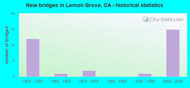
- New bridges - historical statistics
- 121950-1959
- 11960-1969
- 21970-1979
- 11990-1999
- 152000-2009

- Reconstructed bridges - Historical Statistics
- 21960-1969
- 21970-1979
- 01980-1989
- 11990-1999


- Bridge Condition - Deck
- 18.8%Good
- 81.3%Fair

- Bridge Condition - Substructure
- 93.8%Good
- 6.3%Fair
Find on map >> Show street view
Structure Number: 57 0301, Location: 11-SD-005-R28.16-SD (Lat: 32.868061, Lng: -117.229975), Route carried "on" structure: City street , Year Built: 1966, Year Reconstructed: 1990, Status: Open, Structure Length: 6.95m (22.80ft), Average Daily Traffic: 21,500 (year 2020), Truck Traffic: 2%, Average Future Daily Traffic: 24,993 (year 2040), Design Load: HS 20, Features Intersected: INTERSTATE 5, Facility Carried by Structure: NOBEL DRIVE
Minimum Vertical Clearance: 30+ m (98+ ft), Kilometerpoint: 0.000, Lanes on structure: 6, Lanes under structure: 8, Owner: State Highway Agency, Approaching Roadway Width: 24.4m (80.1ft), Skew: 1 degrees, Material/Design: Concrete continuous, Design/Construction: Box Beam or Girders - Multiple, Number Of Spans In Main Unit: 2, Length of Maximum Span: 35.4m (116.1ft), Curb or Sidewalk Widths: Left: 1.5m (4.9ft), Right: 1.5m (4.9ft), Curb-To-Curb Width: 24.4m (80.1ft), Out-to-Out Width: 28.0m (91.9ft)
Condition: Deck: Fair, Superstructure: Good, Substructure: Good, Operating Rating: 54.1 metric tons, Method Used To Determine Operating Rating: Assigned rating based on Load Factor Design (LFD) reported in metric tons, Inventory Rating: 32.4 metric tons, Method Used To Determine Inventory Rating: Assigned rating based on Load Factor Design (LFD) reported in metric tons, Structural Evaluation: Better than present minimum criteria, Deck Geometry: Somewhat better than minimum adequacy, Underclear: Meets minimum limits, Approach Roadway Alignment: Superior to present desirable criteria, Designated Inspection Frequency: Every 24 months, Inspection Date: April 2021, Deck Structure Type: Concrete Cast-file-Place
Find on map >> Show street view
Structure Number: 57 0302L, Location: 11-SD-094-7.76-LMGR (Lat: 32.741850, Lng: -117.050917), Route carried "on" structure: State highway 94, Year Built: 1956, Year Reconstructed: 1968, Status: Open, Structure Length: 2.56m (8.40ft), Average Daily Traffic: 74,000 (year 2016), Truck Traffic: 5%, Average Future Daily Traffic: 84,581 (year 2040), Design Load: HS 20, Features Intersected: COLLEGE AVENUE
Minimum Vertical Clearance: 5.46m (17.91ft), Kilometerpoint: 7.760, Lanes on structure: 5, Lanes under structure: 4, Base Highway Network: Yes (, Subroute: 1), Owner: State Highway Agency, Approaching Roadway Width: 23.2m (76.1ft), Material/Design: Steel, Design/Construction: Stringer/Multi-beam, Number Of Spans In Main Unit: 1, Length of Maximum Span: 24.4m (80.1ft), Curb-To-Curb Width: 23.2m (76.1ft), Out-to-Out Width: 24.2m (79.4ft)
Condition: Deck: Fair, Superstructure: Good, Substructure: Good, Operating Rating: 91.0 metric tons, Method Used To Determine Operating Rating: Load Factor (LF), Inventory Rating: 54.4 metric tons, Method Used To Determine Inventory Rating: Load Factor (LF), Structural Evaluation: Better than present minimum criteria, Deck Geometry: Somewhat better than minimum adequacy, Underclear: Meets minimum limits, Approach Roadway Alignment: Equal to present desirable criteria, Designated Inspection Frequency: Every 24 months, Inspection Date: December 2020, Deck Structure Type: Concrete Cast-file-Place
Find on map >> Show street view
Structure Number: 57 0302R, Location: 11-SD-094-7.76-LMGR (Lat: 32.741619, Lng: -117.050575), Route carried "on" structure: State highway 94, Year Built: 1956, Year Reconstructed: 1968, Status: Open, Structure Length: 2.56m (8.40ft), Average Daily Traffic: 76,000 (year 2016), Truck Traffic: 5%, Average Future Daily Traffic: 84,581 (year 2040), Design Load: HS 20, Features Intersected: COLLEGE AVENUE
Minimum Vertical Clearance: 5.74m (18.83ft), Kilometerpoint: 7.760, Lanes on structure: 5, Lanes under structure: 4, Base Highway Network: Yes (, Subroute: 1), Owner: State Highway Agency, Approaching Roadway Width: 23.2m (76.1ft), Material/Design: Steel, Design/Construction: Stringer/Multi-beam, Number Of Spans In Main Unit: 1, Length of Maximum Span: 24.4m (80.1ft), Curb-To-Curb Width: 23.2m (76.1ft), Out-to-Out Width: 24.2m (79.4ft)
Condition: Deck: Fair, Superstructure: Good, Substructure: Good, Operating Rating: 83.9 metric tons, Method Used To Determine Operating Rating: Load Factor (LF), Inventory Rating: 50.2 metric tons, Method Used To Determine Inventory Rating: Load Factor (LF), Structural Evaluation: Better than present minimum criteria, Deck Geometry: Somewhat better than minimum adequacy, Underclear: Meets minimum limits, Approach Roadway Alignment: Equal to present desirable criteria, Designated Inspection Frequency: Every 24 months, Inspection Date: December 2020, Deck Structure Type: Concrete Cast-file-Place
Find on map >> Show street view
Structure Number: 57 0303C, Location: 11-SD-094-7.83-LMGR (Lat: 32.742483, Lng: -117.049653), Route carried "on" structure: Ramp State highway 94, Year Built: 1956, Status: Open, Structure Length: 3.47m (11.38ft), Average Daily Traffic: 4,300 (year 2016), Truck Traffic: 2%, Average Future Daily Traffic: 8,410 (year 2040), Design Load: HS 20, Features Intersected: STATE ROUTE 94 EB
Minimum Vertical Clearance: 30+ m (98+ ft), Kilometerpoint: 7.830, Lanes on structure: 1, Lanes under structure: 4, Base Highway Network: Yes (, Subroute: 1), Owner: State Highway Agency, Approaching Roadway Width: 7.0m (23.0ft), Skew: 9 degrees, Material/Design: Steel, Design/Construction: Stringer/Multi-beam, Number Of Spans In Main Unit: 1, Length of Maximum Span: 33.2m (108.9ft), Curb-To-Curb Width: 7.1m (23.3ft), Out-to-Out Width: 8.1m (26.6ft)
Condition: Deck: Fair, Superstructure: Good, Substructure: Good, Operating Rating: 67.1 metric tons, Method Used To Determine Operating Rating: Load Factor (LF), Inventory Rating: 40.2 metric tons, Method Used To Determine Inventory Rating: Load Factor (LF), Structural Evaluation: Better than present minimum criteria, Deck Geometry: Equal to present minimum criteria, Underclear: High priority of corrective action, Approach Roadway Alignment: Equal to present desirable criteria, Designated Inspection Frequency: Every 24 months, Inspection Date: December 2020, Deck Structure Type: Concrete Cast-file-Place
Find on map >> Show street view
Structure Number: 57 0304, Location: 11-SD-094-8.28-LMGR (Lat: 32.744844, Lng: -117.042814), Route carried "on" structure: State highway 94, Year Built: 1957, Year Reconstructed: 1976, Status: Open, Structure Length: 4.97m (16.31ft), Average Daily Traffic: 157,000 (year 2019), Truck Traffic: 5%, Average Future Daily Traffic: 170,860 (year 2041), Design Load: HS 20, Features Intersected: MASSACHUSETTS AVE
Minimum Vertical Clearance: 5.23m (17.16ft), Kilometerpoint: 8.280, Lanes on structure: 9, Lanes under structure: 5, Base Highway Network: Yes (, Subroute: 1), Owner: State Highway Agency, Approaching Roadway Width: 42.1m (138.1ft), Skew: 30 degrees, Material/Design: Steel, Design/Construction: Stringer/Multi-beam, Number Of Spans In Main Unit: 1, Number Of Approach Spans: 2, Length of Maximum Span: 25.0m (82.0ft), Curb-To-Curb Width: 42.1m (138.1ft), Out-to-Out Width: 44.3m (145.3ft)
Condition: Deck: Fair, Superstructure: Good, Substructure: Good, Operating Rating: 36.6 metric tons, Method Used To Determine Operating Rating: Load and Resistance Factor Rating (LRFR) rating reported by rating factor(RF) method using HL-93 loadings, Inventory Rating: 28.2 metric tons, Method Used To Determine Inventory Rating: Load and Resistance Factor Rating (LRFR) rating reported by rating factor(RF) method using HL-93 loadings, Structural Evaluation: Better than present minimum criteria, Deck Geometry: Superior to present desirable criteria, Underclear: Meets minimum limits, Approach Roadway Alignment: Equal to present desirable criteria, Designated Inspection Frequency: Every 24 months, Inspection Date: January 2021, Deck Structure Type: Concrete Cast-file-Place
Find on map >> Show street view
Structure Number: 57 0305, Location: 11-SD-094-8.77-LMGR (Lat: 32.745203, Lng: -117.034558), Route carried "on" structure: State highway 94, Year Built: 1957, Year Reconstructed: 1976, Status: Open, Structure Length: 4.75m (15.58ft), Average Daily Traffic: 136,000 (year 2009), Truck Traffic: 5%, Average Future Daily Traffic: 169,726 (year 2037), Design Load: HS 20, Features Intersected: WAITE DRIVE
Minimum Vertical Clearance: 30+ m (98+ ft), Kilometerpoint: 8.770, Lanes on structure: 9, Lanes under structure: 2, Base Highway Network: Yes (, Subroute: 1), Owner: State Highway Agency, Approaching Roadway Width: 46.9m (153.9ft), Skew: 39 degrees, Material/Design: Concrete, Design/Construction: Box Beam or Girders - Multiple, Number Of Spans In Main Unit: 1, Number Of Approach Spans: 2, Length of Maximum Span: 24.4m (80.1ft), Curb-To-Curb Width: 47.0m (154.2ft), Out-to-Out Width: 48.8m (160.1ft)
Condition: Deck: Good, Superstructure: Good, Substructure: Good, Operating Rating: 53.5 metric tons, Method Used To Determine Operating Rating: Load Factor (LF), Inventory Rating: 32.4 metric tons, Method Used To Determine Inventory Rating: Load Factor (LF), Structural Evaluation: Better than present minimum criteria, Deck Geometry: Superior to present desirable criteria, Underclear: Meets minimum limits, Approach Roadway Alignment: Equal to present desirable criteria, Designated Inspection Frequency: Every 48 months, Inspection Date: January 2019, Deck Structure Type: Concrete Cast-file-Place, Wearing Surface/Protective System: Wearing Surface: Monolithic Concrete
Find on map >> Show street view
Structure Number: 57 0796, Location: 11-SD-094-9.04-LMGR (Lat: 32.746844, Lng: -117.031372), Route carried "on" structure: City street , Year Built: 1976, Status: Open, Structure Length: 8.90m (29.20ft), Average Daily Traffic: 2,230 (year 2020), Truck Traffic: 2%, Average Future Daily Traffic: 5,345 (year 2043), Design Load: HS 20, Features Intersected: SR 94 & W94-LEMON GROVE, Facility Carried by Structure: LEMON GROVE AVENUE
Minimum Vertical Clearance: 30+ m (98+ ft), Kilometerpoint: 0.000, Lanes on structure: 3, Lanes under structure: 9, Owner: State Highway Agency, Approaching Roadway Width: 19.2m (63.0ft), Skew: 1 degrees, Material/Design: Prestressed concrete, Design/Construction: Tee Beam, Number Of Spans In Main Unit: 3, Length of Maximum Span: 30.2m (99.1ft), Curb or Sidewalk Widths: Left: 0.0m, Right: 1.5m (4.9ft), Curb-To-Curb Width: 19.3m (63.3ft), Out-to-Out Width: 21.6m (70.9ft)
Condition: Deck: Fair, Superstructure: Good, Substructure: Good, Operating Rating: 65.8 metric tons, Method Used To Determine Operating Rating: Load and Resistance Factor Rating (LRFR) rating reported by rating factor(RF) method using HL-93 loadings, Inventory Rating: 47.3 metric tons, Method Used To Determine Inventory Rating: Load and Resistance Factor Rating (LRFR) rating reported by rating factor(RF) method using HL-93 loadings, Structural Evaluation: Better than present minimum criteria, Deck Geometry: Superior to present desirable criteria, Underclear: Meets minimum limits, Approach Roadway Alignment: Equal to present desirable criteria, Designated Inspection Frequency: Every 24 months, Inspection Date: January 2021, Deck Structure Type: Concrete Cast-file-Place
Find on map >> Show street view
Structure Number: 57 103, Location: 11-SD-078-6.19-VSTA (Lat: 33.194847, Lng: -117.250089), Route carried "on" structure: City street , Year Built: 1998, Status: Open, Structure Length: 6.86m (22.51ft), Average Daily Traffic: 32,200 (year 2012), Truck Traffic: 1%, Average Future Daily Traffic: 47,937 (year 2040), Design Load: HS 20+Mod, Features Intersected: STATE ROUTE 78, Facility Carried by Structure: VISTA VILLAGE DR
Minimum Vertical Clearance: 30+ m (98+ ft), Kilometerpoint: 0.000, Lanes on structure: 7, Lanes under structure: 6, Owner: State Highway Agency, Approaching Roadway Width: 34.7m (113.8ft), Skew: 9 degrees, Material/Design: Concrete continuous, Design/Construction: Box Beam or Girders - Multiple, Number Of Spans In Main Unit: 2, Length of Maximum Span: 36.0m (118.1ft), Curb or Sidewalk Widths: Left: 0.0m, Right: 1.5m (4.9ft), Curb-To-Curb Width: 31.1m (102.0ft), Out-to-Out Width: 34.7m (113.8ft)
Condition: Deck: Fair, Superstructure: Good, Substructure: Good, Operating Rating: 54.1 metric tons, Method Used To Determine Operating Rating: Assigned rating based on Load Factor Design (LFD) reported in metric tons, Inventory Rating: 32.4 metric tons, Method Used To Determine Inventory Rating: Assigned rating based on Load Factor Design (LFD) reported in metric tons, Structural Evaluation: Better than present minimum criteria, Deck Geometry: Better than present minimum criteria, Underclear: Equal to present minimum criteria, Approach Roadway Alignment: Equal to present desirable criteria, Designated Inspection Frequency: Every 24 months, Inspection Date: April 2021, Deck Structure Type: Concrete Cast-file-Place
Find on map >> Show street view
Structure Number: 57 1037L, Location: 11-SD-125-11.35-LMGR (Lat: 32.724736, Lng: -117.014794), Route carried "on" structure: State highway 125, Year Built: 2002, Status: Open, Structure Length: 4.23m (13.88ft), Average Daily Traffic: 66,500 (year 2018), Truck Traffic: 4%, Average Future Daily Traffic: 77,280 (year 2037), Design Load: HS 20, Features Intersected: BLOSSOM LANE
Minimum Vertical Clearance: 30+ m (98+ ft), Kilometerpoint: 11.350, Lanes on structure: 3, Lanes under structure: 3, Base Highway Network: Yes (Inventory Route: 1, Subroute: 1), Owner: State Highway Agency, Approaching Roadway Width: 16.8m (55.1ft), Material/Design: Prestressed concrete, Design/Construction: Box Beam or Girders - Multiple, Number Of Spans In Main Unit: 1, Length of Maximum Span: 42.3m (138.8ft), Curb-To-Curb Width: 16.8m (55.1ft), Out-to-Out Width: 17.8m (58.4ft)
Condition: Deck: Fair, Superstructure: Good, Substructure: Good, Operating Rating: 54.1 metric tons, Method Used To Determine Operating Rating: Assigned rating based on Load Factor Design (LFD) reported in metric tons, Inventory Rating: 32.4 metric tons, Method Used To Determine Inventory Rating: Assigned rating based on Load Factor Design (LFD) reported in metric tons, Structural Evaluation: Better than present minimum criteria, Deck Geometry: Equal to present minimum criteria, Underclear: Somewhat better than minimum adequacy, Approach Roadway Alignment: Equal to present desirable criteria, Designated Inspection Frequency: Every 24 months, Inspection Date: July 2020, Deck Structure Type: Concrete Cast-file-Place
Find on map >> Show street view
Structure Number: 57 1037R, Location: 11-SD-125-11.35-LMGR (Lat: 32.724742, Lng: -117.014408), Route carried "on" structure: State highway 125, Year Built: 2002, Status: Open, Structure Length: 4.12m (13.52ft), Average Daily Traffic: 66,500 (year 2018), Truck Traffic: 4%, Average Future Daily Traffic: 77,280 (year 2037), Design Load: HS 20, Features Intersected: BLOSSOM LANE
Minimum Vertical Clearance: 30+ m (98+ ft), Kilometerpoint: 11.350, Lanes on structure: 3, Lanes under structure: 3, Base Highway Network: Yes (Inventory Route: 1, Subroute: 1), Owner: State Highway Agency, Approaching Roadway Width: 16.8m (55.1ft), Material/Design: Prestressed concrete, Design/Construction: Box Beam or Girders - Multiple, Number Of Spans In Main Unit: 1, Length of Maximum Span: 41.2m (135.2ft), Curb-To-Curb Width: 16.8m (55.1ft), Out-to-Out Width: 17.8m (58.4ft)
Condition: Deck: Fair, Superstructure: Good, Substructure: Good, Operating Rating: 54.1 metric tons, Method Used To Determine Operating Rating: Assigned rating based on Load Factor Design (LFD) reported in metric tons, Inventory Rating: 32.4 metric tons, Method Used To Determine Inventory Rating: Assigned rating based on Load Factor Design (LFD) reported in metric tons, Structural Evaluation: Better than present minimum criteria, Deck Geometry: Equal to present minimum criteria, Underclear: Somewhat better than minimum adequacy, Approach Roadway Alignment: Equal to present desirable criteria, Designated Inspection Frequency: Every 24 months, Inspection Date: July 2020, Deck Structure Type: Concrete Cast-file-Place
Find on map >> Show street view
Structure Number: 57 1038L, Location: 11-SD-125-10.65-LMGR (Lat: 32.714514, Lng: -117.014356), Route carried "on" structure: State highway 125, Year Built: 2002, Status: Open, Structure Length: 5.15m (16.90ft), Average Daily Traffic: 66,500 (year 2018), Truck Traffic: 4%, Average Future Daily Traffic: 77,280 (year 2037), Design Load: HS 20, Features Intersected: JAMACHA ROAD
Minimum Vertical Clearance: 30+ m (98+ ft), Kilometerpoint: 10.650, Lanes on structure: 3, Lanes under structure: 6, Base Highway Network: Yes (Inventory Route: 1, Subroute: 1), Owner: State Highway Agency, Approaching Roadway Width: 16.8m (55.1ft), Skew: 1 degrees, Material/Design: Prestressed concrete, Design/Construction: Box Beam or Girders - Multiple, Number Of Spans In Main Unit: 1, Length of Maximum Span: 51.5m (169.0ft), Curb-To-Curb Width: 16.8m (55.1ft), Out-to-Out Width: 17.8m (58.4ft)
Condition: Deck: Fair, Superstructure: Good, Substructure: Good, Operating Rating: 54.1 metric tons, Method Used To Determine Operating Rating: Assigned rating based on Load Factor Design (LFD) reported in metric tons, Inventory Rating: 32.4 metric tons, Method Used To Determine Inventory Rating: Assigned rating based on Load Factor Design (LFD) reported in metric tons, Structural Evaluation: Better than present minimum criteria, Deck Geometry: Equal to present minimum criteria, Underclear: Somewhat better than minimum adequacy, Approach Roadway Alignment: Equal to present desirable criteria, Designated Inspection Frequency: Every 24 months, Inspection Date: July 2020, Deck Structure Type: Concrete Cast-file-Place
Find on map >> Show street view
Structure Number: 57 1038R, Location: 11-SD-125-10.65-LMGR (Lat: 32.714522, Lng: -117.013958), Route carried "on" structure: State highway 125, Year Built: 2002, Status: Open, Structure Length: 5.07m (16.63ft), Average Daily Traffic: 66,500 (year 2018), Truck Traffic: 4%, Average Future Daily Traffic: 77,280 (year 2037), Design Load: HS 20, Features Intersected: JAMACHA ROAD
Minimum Vertical Clearance: 30+ m (98+ ft), Kilometerpoint: 10.650, Lanes on structure: 3, Lanes under structure: 6, Base Highway Network: Yes (Inventory Route: 1, Subroute: 1), Owner: State Highway Agency, Approaching Roadway Width: 16.9m (55.4ft), Skew: 1 degrees, Material/Design: Prestressed concrete, Design/Construction: Box Beam or Girders - Multiple, Number Of Spans In Main Unit: 1, Length of Maximum Span: 50.7m (166.3ft), Curb-To-Curb Width: 16.9m (55.4ft), Out-to-Out Width: 17.9m (58.7ft)
Condition: Deck: Fair, Superstructure: Good, Substructure: Good, Operating Rating: 54.1 metric tons, Method Used To Determine Operating Rating: Assigned rating based on Load Factor Design (LFD) reported in metric tons, Inventory Rating: 32.4 metric tons, Method Used To Determine Inventory Rating: Assigned rating based on Load Factor Design (LFD) reported in metric tons, Structural Evaluation: Better than present minimum criteria, Deck Geometry: Equal to present minimum criteria, Underclear: Somewhat better than minimum adequacy, Approach Roadway Alignment: Equal to present desirable criteria, Designated Inspection Frequency: Every 24 months, Inspection Date: July 2020, Deck Structure Type: Concrete Cast-file-Place
Find on map >> Show street view
Structure Number: 57 1039, Location: 11-SD-125-12.10-LMGR (Lat: 32.736028, Lng: -117.016736), Route carried "on" structure: City street , Year Built: 2002, Status: Open, Structure Length: 13.23m (43.41ft), Average Daily Traffic: 7,600 (year 2015), Truck Traffic: 1%, Average Future Daily Traffic: 10,304 (year 2037), Design Load: HS 20, Features Intersected: STATE ROUTE 125, Facility Carried by Structure: TROY STREET
Minimum Vertical Clearance: 30+ m (98+ ft), Kilometerpoint: 0.000, Lanes on structure: 4, Lanes under structure: 6, Owner: State Highway Agency, Approaching Roadway Width: 23.4m (76.8ft), Material/Design: Prestressed concrete continuous, Design/Construction: Box Beam or Girders - Multiple, Number Of Spans In Main Unit: 3, Length of Maximum Span: 50.0m (164.0ft), Curb or Sidewalk Widths: Left: 1.5m (4.9ft), Right: 3.0m (9.8ft), Curb-To-Curb Width: 23.4m (76.8ft), Out-to-Out Width: 28.5m (93.5ft)
Condition: Deck: Fair, Superstructure: Good, Substructure: Good, Operating Rating: 62.9 metric tons, Method Used To Determine Operating Rating: Load and Resistance Factor Rating (LRFR) rating reported by rating factor(RF) method using HL-93 loadings, Inventory Rating: 48.3 metric tons, Method Used To Determine Inventory Rating: Load and Resistance Factor Rating (LRFR) rating reported by rating factor(RF) method using HL-93 loadings, Structural Evaluation: Better than present minimum criteria, Deck Geometry: Superior to present desirable criteria, Underclear: Somewhat better than minimum adequacy, Approach Roadway Alignment: Equal to present desirable criteria, Designated Inspection Frequency: Every 24 months, Inspection Date: July 2020, Deck Structure Type: Concrete Cast-file-Place
Find on map >> Show street view
Structure Number: 57 1050L, Location: 11-SD-125-19.84-ECJ (Lat: 32.802403, Lng: -117.005581), Route carried "on" structure: State highway 125, Year Built: 2003, Status: Open, Structure Length: 4.72m (15.49ft), Average Daily Traffic: 19,500 (year 2010), Truck Traffic: 1%, Average Future Daily Traffic: 32,279 (year 2042), Design Load: HS 20, Features Intersected: NAVAJO ROAD
Minimum Vertical Clearance: 30+ m (98+ ft), Kilometerpoint: 19.840, Lanes on structure: 4, Lanes under structure: 8, Base Highway Network: Yes (Inventory Route: 1, Subroute: 1), Owner: State Highway Agency, Approaching Roadway Width: 20.2m (66.3ft), Material/Design: Prestressed concrete continuous, Design/Construction: Box Beam or Girders - Multiple, Number Of Spans In Main Unit: 1, Length of Maximum Span: 47.2m (154.9ft), Curb-To-Curb Width: 20.2m (66.3ft), Out-to-Out Width: 21.2m (69.6ft)
Condition: Deck: Good, Superstructure: Good, Substructure: Fair, Operating Rating: 54.1 metric tons, Method Used To Determine Operating Rating: Assigned rating based on Load Factor Design (LFD) reported in metric tons, Inventory Rating: 32.4 metric tons, Method Used To Determine Inventory Rating: Assigned rating based on Load Factor Design (LFD) reported in metric tons, Structural Evaluation: Somewhat better than minimum adequacy, Deck Geometry: Equal to present minimum criteria, Underclear: Somewhat better than minimum adequacy, Approach Roadway Alignment: Equal to present desirable criteria, Designated Inspection Frequency: Every 24 months, Inspection Date: August 2020, Deck Structure Type: Concrete Cast-file-Place, Wearing Surface/Protective System: Wearing Surface: Integral Concrete
Find on map >> Show street view
Structure Number: 57 1055G, Location: 11-SD-094-R9.58R-LMGR (Lat: 32.745533, Lng: -117.019914), Route carried "on" structure: Ramp State highway 94, Year Built: 2003, Status: Open, Structure Length: 41.25m (135.33ft), Average Daily Traffic: 15,500 (year 2020), Truck Traffic: 4%, Average Future Daily Traffic: 18,984 (year 2041), Design Load: HS 20+Mod, Features Intersected: BROADWAY
Minimum Vertical Clearance: 30+ m (98+ ft), Kilometerpoint: 9.580, Lanes on structure: 2, Lanes under structure: 2, Base Highway Network: Yes, Owner: State Highway Agency, Approaching Roadway Width: 11.7m (38.4ft), Skew: 9 degrees, Material/Design: Prestressed concrete continuous, Design/Construction: Box Beam or Girders - Multiple, Number Of Spans In Main Unit: 7, Length of Maximum Span: 64.0m (210.0ft), Curb-To-Curb Width: 11.7m (38.4ft), Out-to-Out Width: 12.8m (42.0ft)
Condition: Deck: Fair, Superstructure: Good, Substructure: Good, Operating Rating: 54.1 metric tons, Method Used To Determine Operating Rating: Assigned rating based on Load Factor Design (LFD) reported in metric tons, Inventory Rating: 32.4 metric tons, Method Used To Determine Inventory Rating: Assigned rating based on Load Factor Design (LFD) reported in metric tons, Structural Evaluation: Better than present minimum criteria, Deck Geometry: Superior to present desirable criteria, Underclear: Somewhat better than minimum adequacy, Approach Roadway Alignment: Equal to present desirable criteria, Designated Inspection Frequency: Every 24 months, Inspection Date: January 2021, Deck Structure Type: Concrete Cast-file-Place
Find on map >> Show street view
Structure Number: 57 1058R, Location: 11-SD-094-R9.74R-LMGR (Lat: 32.747717, Lng: -117.017856), Route carried "on" structure: State highway 94, Year Built: 2003, Status: Open, Structure Length: 11.90m (39.04ft), Average Daily Traffic: 69,000 (year 2020), Truck Traffic: 4%, Average Future Daily Traffic: 91,811 (year 2041), Design Load: HS 20+Mod, Features Intersected: STATE ROUTE 125 NB
Minimum Vertical Clearance: 7.62m (25.00ft), Kilometerpoint: 9.740, Lanes on structure: 2, Lanes under structure: 2, Base Highway Network: Yes (, Subroute: 1), Owner: State Highway Agency, Approaching Roadway Width: 11.7m (38.4ft), Skew: 9 degrees, Material/Design: Prestressed concrete continuous, Design/Construction: Box Beam or Girders - Multiple, Number Of Spans In Main Unit: 3, Length of Maximum Span: 43.0m (141.1ft), Curb-To-Curb Width: 11.7m (38.4ft), Out-to-Out Width: 12.7m (41.7ft)
Condition: Deck: Good, Superstructure: Good, Substructure: Good, Operating Rating: 54.1 metric tons, Method Used To Determine Operating Rating: Assigned rating based on Load Factor Design (LFD) reported in metric tons, Inventory Rating: 32.4 metric tons, Method Used To Determine Inventory Rating: Assigned rating based on Load Factor Design (LFD) reported in metric tons, Structural Evaluation: Better than present minimum criteria, Deck Geometry: Equal to present minimum criteria, Underclear: Meets minimum limits, Approach Roadway Alignment: Equal to present desirable criteria, Designated Inspection Frequency: Every 24 months, Inspection Date: January 2021, Deck Structure Type: Concrete Cast-file-Place
Find on map >> Show street view
Structure Number: 57 0302L, Location: 11-SD-094-7.76-LMGR (Lat: 32.741850, Lng: -117.050917), Route carried "under" structure: City street S138, Year Built: 1956, Structure Length: 0. m, Average Daily Traffic: 28,740 (year 2016), Truck Traffic: 2%, Features Intersected: COLLEGE AVENUE, Facility Carried by Structure: STATE ROUTE 94 WB
Minimum Vertical Clearance: 5.91m (19.39ft), Kilometerpoint: 0.000, Lanes on structure: 5, Lanes under structure: 4, Material/Design: Steel, Design/Construction: Stringer/Multi-beam, Length of Maximum Span: 24.4m (80.1ft)
Find on map >> Show street view
Structure Number: 57 0302R, Location: 11-SD-094-7.76-LMGR (Lat: 32.741619, Lng: -117.050575), Route carried "under" structure: City street S138, Year Built: 1956, Structure Length: 0. m, Average Daily Traffic: 28,740 (year 2016), Truck Traffic: 2%, Features Intersected: COLLEGE AVENUE, Facility Carried by Structure: STATE ROUTE 94 EB
Minimum Vertical Clearance: 4.62m (15.16ft), Kilometerpoint: 0.000, Lanes on structure: 5, Lanes under structure: 4, Material/Design: Steel, Design/Construction: Stringer/Multi-beam, Length of Maximum Span: 24.4m (80.1ft)
Find on map >> Show street view
Structure Number: 57 0303C, Location: 11-SD-094-7.83-LMGR (Lat: 32.742483, Lng: -117.049653), Route carried "under" structure: State highway 94, Year Built: 1956, Structure Length: 0. m, Average Daily Traffic: 65,000 (year 2016), Truck Traffic: 4%, Features Intersected: STATE ROUTE 94 EB
Minimum Vertical Clearance: 5.25m (17.22ft), Kilometerpoint: 7.830, Lanes on structure: 1, Lanes under structure: 4, Material/Design: Steel, Design/Construction: Stringer/Multi-beam, Length of Maximum Span: 33.2m (108.9ft)
Find on map >> Show street view
Structure Number: 57 0304, Location: 11-SD-094-8.28-LMGR (Lat: 32.744844, Lng: -117.042814), Route carried "under" structure: City street S263, Year Built: 1957, Structure Length: 0. m, Average Daily Traffic: 28,800 (year 2020), Truck Traffic: 2%, Features Intersected: MASSACHUSETTS AVE, Facility Carried by Structure: STATE ROUTE 94
Minimum Vertical Clearance: 4.62m (15.16ft), Kilometerpoint: 0.000, Lanes on structure: 9, Lanes under structure: 5, Material/Design: Steel, Design/Construction: Stringer/Multi-beam, Length of Maximum Span: 25.0m (82.0ft)
Find on map >> Show street view
Structure Number: 57 0305, Location: 11-SD-094-8.77-LMGR (Lat: 32.745203, Lng: -117.034558), Route carried "under" structure: City street , Year Built: 1957, Structure Length: 0. m, Average Daily Traffic: 8,500 (year 2005), Truck Traffic: 2%, Features Intersected: WAITE DRIVE, Facility Carried by Structure: STATE ROUTE 94
Minimum Vertical Clearance: 4.75m (15.58ft), Kilometerpoint: 0.000, Lanes on structure: 9, Lanes under structure: 2, Material/Design: Concrete, Design/Construction: Box Beam or Girders - Multiple, Length of Maximum Span: 24.4m (80.1ft)
Find on map >> Show street view
Structure Number: 57 0306, Location: 11-SD-094-9.23-LMGR (Lat: 32.747372, Lng: -117.026731), Route carried "under" structure: State highway 94, Year Built: 1957, Structure Length: 0. m, Average Daily Traffic: 138,000 (year 2010), Truck Traffic: 5%, Features Intersected: STATE ROUTE 94, Facility Carried by Structure: MTDB LRT & SDIV RR
Minimum Vertical Clearance: 4.67m (15.32ft), Kilometerpoint: 9.230, Lanes under structure: 8, Material/Design: Steel, Design/Construction: Girder and Floorbeam System, Length of Maximum Span: 37.5m (123.0ft)
Find on map >> Show street view
Structure Number: 57 0322, Location: 11-SD-094-9.26-LMGR (Lat: 32.747125, Lng: -117.026633), Route carried "under" structure: State highway 94, Year Built: 1957, Structure Length: 0. m, Average Daily Traffic: 147,000 (year 2019), Truck Traffic: 5%, Features Intersected: STATE ROUTE 94, Facility Carried by Structure: GROVE STREET
Minimum Vertical Clearance: 5.23m (17.16ft), Kilometerpoint: 9.260, Lanes on structure: 2, Lanes under structure: 8, Material/Design: Concrete continuous, Design/Construction: Box Beam or Girders - Multiple, Length of Maximum Span: 35.4m (116.1ft)
Find on map >> Show street view
Structure Number: 57 0796, Location: 11-SD-094-9.04-LMGR (Lat: 32.746844, Lng: -117.031372), Route carried "under" structure: State highway 94, Year Built: 1976, Structure Length: 0. m, Average Daily Traffic: 156,000 (year 2019), Truck Traffic: 5%, Features Intersected: SR 94 & W94-LEMON GROVE, Facility Carried by Structure: LEMON GROVE AVENUE
Minimum Vertical Clearance: 5.49m (18.01ft), Kilometerpoint: 9.040, Lanes on structure: 3, Lanes under structure: 9, Material/Design: Prestressed concrete, Design/Construction: Tee Beam, Length of Maximum Span: 30.2m (99.1ft)
Find on map >> Show street view
Structure Number: 57 1037L, Location: 11-SD-125-11.35-LMGR (Lat: 32.724736, Lng: -117.014794), Route carried "under" structure: City street , Year Built: 2002, Structure Length: 0. m, Average Daily Traffic: 3,600 (year 2015), Truck Traffic: 1%, Features Intersected: BLOSSOM LANE, Facility Carried by Structure: STATE ROUTE 125 SB
Minimum Vertical Clearance: 6.00m (19.69ft), Kilometerpoint: 0.000, Lanes on structure: 3, Lanes under structure: 3, Material/Design: Prestressed concrete, Design/Construction: Box Beam or Girders - Multiple, Length of Maximum Span: 42.3m (138.8ft)
Find on map >> Show street view
Structure Number: 57 1037R, Location: 11-SD-125-11.35-LMGR (Lat: 32.724742, Lng: -117.014408), Route carried "under" structure: City street , Year Built: 2002, Structure Length: 0. m, Average Daily Traffic: 3,600 (year 2015), Truck Traffic: 1%, Features Intersected: BLOSSOM LANE, Facility Carried by Structure: STATE ROUTE 125 NB
Minimum Vertical Clearance: 5.43m (17.81ft), Kilometerpoint: 0.000, Lanes on structure: 3, Lanes under structure: 3, Material/Design: Prestressed concrete, Design/Construction: Box Beam or Girders - Multiple, Length of Maximum Span: 41.2m (135.2ft)
Find on map >> Show street view
Structure Number: 57 1038L, Location: 11-SD-125-10.65-LMGR (Lat: 32.714514, Lng: -117.014356), Route carried "under" structure: City street , Year Built: 2002, Structure Length: 0. m, Average Daily Traffic: 21,900 (year 2015), Truck Traffic: 1%, Features Intersected: JAMACHA ROAD, Facility Carried by Structure: STATE ROUTE 125
Minimum Vertical Clearance: 6.07m (19.91ft), Kilometerpoint: 0.000, Lanes on structure: 3, Lanes under structure: 6, Material/Design: Prestressed concrete, Design/Construction: Box Beam or Girders - Multiple, Length of Maximum Span: 51.5m (169.0ft)
Find on map >> Show street view
Structure Number: 57 1038R, Location: 11-SD-125-10.65-LMGR (Lat: 32.714522, Lng: -117.013958), Route carried "under" structure: City street , Year Built: 2002, Structure Length: 0. m, Average Daily Traffic: 21,900 (year 2015), Truck Traffic: 1%, Features Intersected: JAMACHA ROAD, Facility Carried by Structure: STATE ROUTE 125
Minimum Vertical Clearance: 5.58m (18.31ft), Kilometerpoint: 0.000, Lanes on structure: 3, Lanes under structure: 6, Material/Design: Prestressed concrete, Design/Construction: Box Beam or Girders - Multiple, Length of Maximum Span: 50.7m (166.3ft)
Find on map >> Show street view
Structure Number: 57 1039, Location: 11-SD-125-12.10-LMGR (Lat: 32.736028, Lng: -117.016736), Route carried "under" structure: State highway 125, Year Built: 2002, Structure Length: 0. m, Average Daily Traffic: 133,000 (year 2018), Truck Traffic: 2%, Features Intersected: STATE ROUTE 125, Facility Carried by Structure: TROY STREET
Minimum Vertical Clearance: 5.73m (18.80ft), Kilometerpoint: 12.100, Lanes on structure: 4, Lanes under structure: 6, Material/Design: Prestressed concrete continuous, Design/Construction: Box Beam or Girders - Multiple, Length of Maximum Span: 50.0m (164.0ft)
Find on map >> Show street view
Structure Number: 57 1055G, Location: 11-SD-094-R9.58R-LMGR (Lat: 32.745533, Lng: -117.019914), Route carried "under" structure: City street , Year Built: 2003, Structure Length: 0. m, Average Daily Traffic: 14,000 (year 2020), Truck Traffic: 3%, Features Intersected: BROADWAY, Facility Carried by Structure: E94-S125 CONNECTOR
Minimum Vertical Clearance: 27.43m (89.99ft), Kilometerpoint: 0.000, Lanes on structure: 2, Lanes under structure: 2, Material/Design: Prestressed concrete continuous, Design/Construction: Box Beam or Girders - Multiple, Length of Maximum Span: 64.0m (210.0ft)
Find on map >> Show street view
Structure Number: 57 1058R, Location: 11-SD-094-R9.74R-LMGR (Lat: 32.747717, Lng: -117.017856), Route carried "under" structure: State highway 125, Year Built: 2003, Structure Length: 0. m, Average Daily Traffic: 82,000 (year 2020), Truck Traffic: 5%, Features Intersected: STATE ROUTE 125 NB, Facility Carried by Structure: STATE ROUTE 94 EB
Minimum Vertical Clearance: 5.28m (17.32ft), Kilometerpoint: 14.500, Lanes on structure: 2, Lanes under structure: 2, Material/Design: Prestressed concrete continuous, Design/Construction: Box Beam or Girders - Multiple, Length of Maximum Span: 43.0m (141.1ft)