Bridge Statistics for North Castle, New York (NY)
Condition, Traffic, Stress, Structural Evaluation, Project Costs
- National Bridge Inventory (NBI) Statistics
- 32Number of bridges
- 331ft / 101mTotal length
- $125,232,000Total costs
- 640,165Total average daily traffic
- 25,628Total average daily truck traffic
- National Bridge Inventory (NBI) Registered Bridges for North Castle
- No street view available for this location
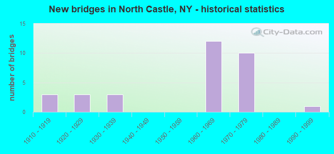
- New bridges - historical statistics
- 31910-1919
- 31920-1929
- 31930-1939
- 121960-1969
- 101970-1979
- 11990-1999

- Reconstructed bridges - Historical Statistics
- 11980-1989
- 21990-1999
- 12000-2009


- Bridge Condition - Deck
- 6.7%Excellent
- 13.3%Very good
- 20.0%Good
- 53.3%Satisfactory
- 6.7%Fair

- Bridge Condition - Superstructure
- 23.5%Good
- 52.9%Satisfactory
- 23.5%Fair

- Bridge Condition - Substructure
- 35.3%Good
- 64.7%Satisfactory

- Bridge Condition - Channel
- 28.6%Very good
- 28.6%Good
- 14.3%Satisfactory
- 28.6%Fair
Find on map >> Show street view
Structure Number: 101655, Location: 1.9 MI N JCT RTS 22+I287 (Lat: 41.071036, Lng: -73.763831), Route carried "on" structure: State highway 22, Year Built: 1930, Status: Open, Structure Length: 2.01m (6.59ft), Average Daily Traffic: 10,571 (year 2017), Truck Traffic: 1%, Average Future Daily Traffic: 10,620 (year 2040), Features Intersected: COUNTY ROAD 68
Minimum Vertical Clearance: 30+ m (98+ ft), Kilometerpoint: 22.381, Lanes on structure: 2, Lanes under structure: 1, Base Highway Network: Yes, Owner: County Highway Agency, Maintenance Responsibility: State Highway Agency, Approaching Roadway Width: 8.7m (28.5ft), Skew: 6 degrees, Material/Design: Steel, Design/Construction: Stringer/Multi-beam, Number Of Spans In Main Unit: 1, Length of Maximum Span: 19.5m (64.0ft), Curb-To-Curb Width: 8.7m (28.5ft), Out-to-Out Width: 13.7m (44.9ft)
Condition: Deck: Fair, Superstructure: Fair, Substructure: Satisfactory, Operating Rating: 67.7 metric tons, Method Used To Determine Operating Rating: Load and Resistance Factor Rating (LRFR) rating reported by rating factor(RF) method using HL-93 loadings, Inventory Rating: 52.2 metric tons, Method Used To Determine Inventory Rating: Load and Resistance Factor Rating (LRFR) rating reported by rating factor(RF) method using HL-93 loadings, Structural Evaluation: Somewhat better than minimum adequacy, Deck Geometry: High priority of replacement, Underclear: High priority of corrective action, Approach Roadway Alignment: Meets minimum limits, Length Of Structure Improvement: 2.01m (6.59ft), Designated Inspection Frequency: Every 24 months, Inspection Date: October 2020, Bridge Improvement Cost: $2,554,000, Roadway Improvement Cost: $1,496,000, Total Project Cost: $4,050,000 ( Estimate for 2021), Deck Structure Type: Concrete Cast-file-Place, Wearing Surface/Protective System: Wearing Surface: Bituminous
Find on map >> Show street view
Structure Number: 101656, Location: 3.7 MI N JCT SH 22 & I287 (Lat: 41.091167, Lng: -73.748017), Route carried "on" structure: State highway 22, Year Built: 1910, Year Reconstructed: 2005, Status: Open, Structure Length: 28.22m (92.59ft), Average Daily Traffic: 10,571 (year 2017), Truck Traffic: 1%, Average Future Daily Traffic: 10,620 (year 2040), Design Load: HS 20, Features Intersected: RYE LAKE OUTLET
Minimum Vertical Clearance: 30+ m (98+ ft), Kilometerpoint: 25.133, Lanes on structure: 4, Base Highway Network: Yes, Owner: State Highway Agency, Approaching Roadway Width: 12.8m (42.0ft), Material/Design: Concrete, Design/Construction: Arch - Deck, Number Of Spans In Main Unit: 9, Number Of Approach Spans: 20, Length of Maximum Span: 39.6m (129.9ft), Curb or Sidewalk Widths: Left: 1.5m (4.9ft), Right: 1.5m (4.9ft), Curb-To-Curb Width: 12.5m (41.0ft), Out-to-Out Width: 17.1m (56.1ft)
Condition: Deck: Excellent, Superstructure: Satisfactory, Substructure: Satisfactory, Channel: Very good, Operating Rating: 70.8 metric tons, Method Used To Determine Operating Rating: Load Factor (LF), Inventory Rating: 42.6 metric tons, Method Used To Determine Inventory Rating: Load Factor (LF), Structural Evaluation: Equal to present minimum criteria, Deck Geometry: High priority of replacement, Waterway Adequacy: Equal to present minimum criteria, Approach Roadway Alignment: Equal to present desirable criteria, Length Of Structure Improvement: 28.22m (92.59ft), Designated Inspection Frequency: Every 24 months, Critical Feature Inspection Frequency: Every 24 months, Underwater Inspection Frequency: Every 60 months, Inspection Date: November 2021, Critical Feature Inspection Date: November 2021, Underwater Inspection Date: November 2017, Bridge Improvement Cost: $34,551,000, Roadway Improvement Cost: $20,233,000, Total Project Cost: $54,784,000 ( Estimate for 2021), Deck Structure Type: Other, Wearing Surface/Protective System: Wearing Surface: Monolithic Concrete, Membrane: Other
Find on map >> Show street view
Structure Number: 101657, Location: 5.4 MI N JCT SH 22 & I287 (Lat: 41.108875, Lng: -73.730903), Route carried "on" structure: State highway 22, Year Built: 1937, Status: Open, Structure Length: 1.34m (4.40ft), Average Daily Traffic: 12,642 (year 2008), Truck Traffic: 6%, Average Future Daily Traffic: 12,701 (year 2040), Design Load: HS 20, Features Intersected: BEAR GUTTER CREEK
Minimum Vertical Clearance: 30+ m (98+ ft), Kilometerpoint: 27.948, Lanes on structure: 4, Base Highway Network: Yes, Owner: State Highway Agency, Approaching Roadway Width: 12.2m (40.0ft), Material/Design: Steel, Design/Construction: Stringer/Multi-beam, Number Of Spans In Main Unit: 1, Length of Maximum Span: 13.1m (43.0ft), Curb-To-Curb Width: 14.0m (45.9ft), Out-to-Out Width: 15.4m (50.5ft)
Condition: Deck: Satisfactory, Superstructure: Fair, Substructure: Satisfactory, Channel: Good, Operating Rating: 74.4 metric tons, Method Used To Determine Operating Rating: Load Factor (LF), Inventory Rating: 44.5 metric tons, Method Used To Determine Inventory Rating: Load Factor (LF), Structural Evaluation: Somewhat better than minimum adequacy, Deck Geometry: High priority of replacement, Waterway Adequacy: Equal to present minimum criteria, Approach Roadway Alignment: Meets minimum limits, Length Of Structure Improvement: 1.34m (4.40ft), Designated Inspection Frequency: Every 24 months, Inspection Date: September 2020, Bridge Improvement Cost: $1,291,000, Roadway Improvement Cost: $756,000, Total Project Cost: $2,047,000 ( Estimate for 2021), Deck Structure Type: Concrete Cast-file-Place, Wearing Surface/Protective System: Wearing Surface: Bituminous
Find on map >> Show street view
Structure Number: 101658, Location: 6.8 MI N JCT RTS 22+I287 (Lat: 41.122922, Lng: -73.711058), Route carried "on" structure: State highway 22, Year Built: 1968, Status: Open, Structure Length: 1.01m (3.31ft), Average Daily Traffic: 20,151 (year 2017), Truck Traffic: 3%, Average Future Daily Traffic: 20,245 (year 2040), Features Intersected: WAMPUS RIVER
Minimum Vertical Clearance: 30+ m (98+ ft), Kilometerpoint: 30.362, Lanes on structure: 4, Base Highway Network: Yes, Owner: State Highway Agency, Approaching Roadway Width: 20.1m (65.9ft), Skew: 23 degrees, Material/Design: Concrete continuous, Design/Construction: Culvert, Number Of Spans In Main Unit: 2, Length of Maximum Span: 3.6m (11.8ft)
Condition: Channel: Fair, Culverts: Good, Operating Rating: 97.2 metric tons, Method Used To Determine Operating Rating: Load and Resistance Factor Rating (LRFR) rating reported by rating factor(RF) method using HL-93 loadings, Inventory Rating: 81.3 metric tons, Method Used To Determine Inventory Rating: Load and Resistance Factor Rating (LRFR) rating reported by rating factor(RF) method using HL-93 loadings, Structural Evaluation: Better than present minimum criteria, Waterway Adequacy: Meets minimum limits, Approach Roadway Alignment: Equal to present desirable criteria, Length Of Structure Improvement: 1.00m (3.28ft), Designated Inspection Frequency: Every 24 months, Inspection Date: September 2020, Bridge Improvement Cost: $820,000, Roadway Improvement Cost: $480,000, Total Project Cost: $1,300,000 ( Estimate for 2021), Wearing Surface/Protective System: Wearing Surface: Monolithic Concrete
Find on map >> Show street view
Structure Number: 105296, Location: 0.5 MI S JCT RTS I684+120 (Lat: 41.080164, Lng: -73.718111), Route carried "on" structure: County highway , Year Built: 1969, Status: Open, Structure Length: 6.68m (21.92ft), Average Daily Traffic: 10,555 (year 1997), Truck Traffic: 3%, Average Future Daily Traffic: 14,777 (year 2017), Design Load: HS 20, Features Intersected: 684I684I87011045 SB, RTE, Facility Carried by Structure: CR 135 AIRPORT RD
Minimum Vertical Clearance: 30+ m (98+ ft), Kilometerpoint: 0.000, Lanes on structure: 2, Lanes under structure: 6, Owner: State Highway Agency, Approaching Roadway Width: 11.9m (39.0ft), Material/Design: Steel, Design/Construction: Stringer/Multi-beam, Number Of Spans In Main Unit: 4, Length of Maximum Span: 19.8m (65.0ft), Curb-To-Curb Width: 9.1m (29.9ft), Out-to-Out Width: 10.1m (33.1ft)
Condition: Deck: Satisfactory, Superstructure: Fair, Substructure: Good, Operating Rating: 58.0 metric tons, Method Used To Determine Operating Rating: Load and Resistance Factor Rating (LRFR) rating reported by rating factor(RF) method using HL-93 loadings, Inventory Rating: 44.7 metric tons, Method Used To Determine Inventory Rating: Load and Resistance Factor Rating (LRFR) rating reported by rating factor(RF) method using HL-93 loadings, Structural Evaluation: Somewhat better than minimum adequacy, Deck Geometry: Meets minimum limits, Underclear: High priority of corrective action, Approach Roadway Alignment: Equal to present desirable criteria, Length Of Structure Improvement: 6.67m (21.88ft), Designated Inspection Frequency: Every 24 months, Inspection Date: June 2020, Bridge Improvement Cost: $2,530,000, Roadway Improvement Cost: $1,482,000, Total Project Cost: $4,012,000 ( Estimate for 2021), Deck Structure Type: Concrete Cast-file-Place, Wearing Surface/Protective System: Wearing Surface: Monolithic Concrete
Find on map >> Show street view
Structure Number: 105297, Location: JCT RTS I684+120 (Lat: 41.087608, Lng: -73.717878), Route carried "on" structure: State highway 120, Year Built: 1969, Status: Open, Structure Length: 12.74m (41.80ft), Average Daily Traffic: 6,799 (year 2017), Truck Traffic: 3%, Average Future Daily Traffic: 8,259 (year 2040), Design Load: HS 20, Features Intersected: 684I684I87011051 NB, RTE
Minimum Vertical Clearance: 30+ m (98+ ft), Kilometerpoint: 12.824, Lanes on structure: 2, Lanes under structure: 6, Base Highway Network: Yes, Owner: State Highway Agency, Approaching Roadway Width: 12.8m (42.0ft), Skew: 5 degrees, Material/Design: Steel, Design/Construction: Stringer/Multi-beam, Number Of Spans In Main Unit: 4, Length of Maximum Span: 37.5m (123.0ft), Curb-To-Curb Width: 8.5m (27.9ft), Out-to-Out Width: 10.1m (33.1ft)
Condition: Deck: Satisfactory, Superstructure: Satisfactory, Substructure: Satisfactory, Operating Rating: 38.2 metric tons, Method Used To Determine Operating Rating: Load and Resistance Factor Rating (LRFR) rating reported by rating factor(RF) method using HL-93 loadings, Inventory Rating: 29.2 metric tons, Method Used To Determine Inventory Rating: Load and Resistance Factor Rating (LRFR) rating reported by rating factor(RF) method using HL-93 loadings, Structural Evaluation: Equal to present minimum criteria, Deck Geometry: Meets minimum limits, Underclear: High priority of corrective action, Approach Roadway Alignment: Equal to present desirable criteria, Length Of Structure Improvement: 12.74m (41.80ft), Designated Inspection Frequency: Every 24 months, Inspection Date: June 2020, Bridge Improvement Cost: $5,319,000, Roadway Improvement Cost: $3,115,000, Total Project Cost: $8,435,000 ( Estimate for 2021), Deck Structure Type: Concrete Cast-file-Place, Wearing Surface/Protective System: Wearing Surface: Latex Concrete
Find on map >> Show street view
Structure Number: 1052991, Location: 1.6 MI N JCT I684 & SH120 (Lat: 41.107778, Lng: -73.712861), Route carried "on" structure: Interstate 684, Year Built: 1969, Status: Open, Structure Length: 1.80m (5.91ft), Average Daily Traffic: 30,092 (year 1999), Truck Traffic: 15%, Design Load: HS 20+Mod, Features Intersected: BYRAM RIVER, BRIDLE PATH
Minimum Vertical Clearance: 30+ m (98+ ft), Kilometerpoint: 10.201, Lanes on structure: 3, Base Highway Network: Yes, Owner: State Highway Agency, Approaching Roadway Width: 15.8m (51.8ft), Skew: 2 degrees, Material/Design: Prestressed concrete, Design/Construction: Box Beam or Girders - Multiple, Number Of Spans In Main Unit: 1, Length of Maximum Span: 17.6m (57.7ft), Curb-To-Curb Width: 15.8m (51.8ft), Out-to-Out Width: 16.7m (54.8ft)
Condition: Deck: Satisfactory, Superstructure: Satisfactory, Substructure: Good, Channel: Good, Operating Rating: 59.9 metric tons, Method Used To Determine Operating Rating: Load and Resistance Factor Rating (LRFR) rating reported by rating factor(RF) method using HL-93 loadings, Inventory Rating: 46.3 metric tons, Method Used To Determine Inventory Rating: Load and Resistance Factor Rating (LRFR) rating reported by rating factor(RF) method using HL-93 loadings, Structural Evaluation: Equal to present minimum criteria, Deck Geometry: Somewhat better than minimum adequacy, Waterway Adequacy: Superior to present desirable criteria, Approach Roadway Alignment: Equal to present desirable criteria, Length Of Structure Improvement: 1.79m (5.87ft), Designated Inspection Frequency: Every 24 months, Inspection Date: May 2020, Bridge Improvement Cost: $1,325,000, Roadway Improvement Cost: $776,000, Total Project Cost: $2,101,000 ( Estimate for 2021), Wearing Surface/Protective System: Wearing Surface: Monolithic Concrete
Find on map >> Show street view
Structure Number: 1052992, Location: 1.6 MI N JCT I684 & SH120 (Lat: 41.107481, Lng: -73.712522), Route carried "on" structure: Interstate 684, Year Built: 1969, Status: Open, Structure Length: 1.80m (5.91ft), Average Daily Traffic: 28,191 (year 2019), Truck Traffic: 9%, Average Future Daily Traffic: 47,738 (year 2040), Design Load: HS 20+Mod, Features Intersected: BYRAM RIVER, BRIDLE PATH
Minimum Vertical Clearance: 30+ m (98+ ft), Kilometerpoint: 10.265, Lanes on structure: 3, Base Highway Network: Yes, Owner: State Highway Agency, Approaching Roadway Width: 14.9m (48.9ft), Skew: 2 degrees, Material/Design: Prestressed concrete, Design/Construction: Box Beam or Girders - Multiple, Number Of Spans In Main Unit: 1, Length of Maximum Span: 17.6m (57.7ft), Curb-To-Curb Width: 15.7m (51.5ft), Out-to-Out Width: 16.7m (54.8ft)
Condition: Deck: Satisfactory, Superstructure: Satisfactory, Substructure: Satisfactory, Channel: Satisfactory, Operating Rating: 62.2 metric tons, Method Used To Determine Operating Rating: Load and Resistance Factor Rating (LRFR) rating reported by rating factor(RF) method using HL-93 loadings, Inventory Rating: 48.0 metric tons, Method Used To Determine Inventory Rating: Load and Resistance Factor Rating (LRFR) rating reported by rating factor(RF) method using HL-93 loadings, Structural Evaluation: Equal to present minimum criteria, Deck Geometry: Somewhat better than minimum adequacy, Waterway Adequacy: Superior to present desirable criteria, Approach Roadway Alignment: Equal to present desirable criteria, Length Of Structure Improvement: 1.79m (5.87ft), Designated Inspection Frequency: Every 24 months, Inspection Date: May 2020, Bridge Improvement Cost: $1,325,000, Roadway Improvement Cost: $776,000, Total Project Cost: $2,101,000 ( Estimate for 2021), Wearing Surface/Protective System: Wearing Surface: Monolithic Concrete
Find on map >> Show street view
Structure Number: 1053001, Location: JCT RTS 22+I684 INT 3 (Lat: 41.124308, Lng: -73.704203), Route carried "on" structure: Interstate 684, Year Built: 1969, Status: Open, Structure Length: 4.85m (15.91ft), Truck Traffic: 15%, Design Load: HS 20+Mod, Features Intersected: 22 22 87034066 WB, RTE
Minimum Vertical Clearance: 30+ m (98+ ft), Kilometerpoint: 12.196, Lanes on structure: 4, Lanes under structure: 6, Base Highway Network: Yes, Owner: State Highway Agency, Approaching Roadway Width: 18.6m (61.0ft), Skew: 1 degrees, Material/Design: Steel, Design/Construction: Stringer/Multi-beam, Number Of Spans In Main Unit: 2, Length of Maximum Span: 25.3m (83.0ft), Curb-To-Curb Width: 16.5m (54.1ft), Out-to-Out Width: 17.7m (58.1ft)
Condition: Deck: Satisfactory, Superstructure: Satisfactory, Substructure: Satisfactory, Operating Rating: 69.3 metric tons, Method Used To Determine Operating Rating: Load and Resistance Factor Rating (LRFR) rating reported by rating factor(RF) method using HL-93 loadings, Inventory Rating: 53.5 metric tons, Method Used To Determine Inventory Rating: Load and Resistance Factor Rating (LRFR) rating reported by rating factor(RF) method using HL-93 loadings, Structural Evaluation: Equal to present minimum criteria, Deck Geometry: High priority of replacement, Underclear: Meets minimum limits, Approach Roadway Alignment: Equal to present desirable criteria, Length Of Structure Improvement: 4.84m (15.88ft), Designated Inspection Frequency: Every 24 months, Inspection Date: October 2020, Bridge Improvement Cost: $3,787,000, Roadway Improvement Cost: $2,218,000, Total Project Cost: $6,005,000 ( Estimate for 2021), Deck Structure Type: Concrete Cast-file-Place, Wearing Surface/Protective System: Wearing Surface: Monolithic Concrete
Find on map >> Show street view
Structure Number: 1053002, Location: JCT RTS 22+I684 INT 3 (Lat: 41.124361, Lng: -73.703908), Route carried "on" structure: Interstate 684, Year Built: 1969, Status: Open, Structure Length: 4.85m (15.91ft), Average Daily Traffic: 28,191 (year 2020), Truck Traffic: 10%, Average Future Daily Traffic: 47,738 (year 2040), Design Load: HS 20+Mod, Features Intersected: 22 22 87034066 SB, RTE 2
Minimum Vertical Clearance: 30+ m (98+ ft), Kilometerpoint: 12.261, Lanes on structure: 4, Lanes under structure: 6, Base Highway Network: Yes, Owner: State Highway Agency, Approaching Roadway Width: 19.2m (63.0ft), Skew: 1 degrees, Material/Design: Steel, Design/Construction: Stringer/Multi-beam, Number Of Spans In Main Unit: 2, Length of Maximum Span: 24.6m (80.7ft), Curb-To-Curb Width: 16.8m (55.1ft), Out-to-Out Width: 17.7m (58.1ft)
Condition: Deck: Good, Superstructure: Fair, Substructure: Satisfactory, Operating Rating: 93.4 metric tons, Method Used To Determine Operating Rating: Load Factor (LF), Inventory Rating: 55.3 metric tons, Method Used To Determine Inventory Rating: Load Factor (LF), Structural Evaluation: Somewhat better than minimum adequacy, Deck Geometry: High priority of replacement, Underclear: Meets minimum limits, Approach Roadway Alignment: Equal to present desirable criteria, Length Of Structure Improvement: 4.84m (15.88ft), Designated Inspection Frequency: Every 24 months, Inspection Date: December 2021, Bridge Improvement Cost: $3,864,000, Roadway Improvement Cost: $2,263,000, Total Project Cost: $6,127,000 ( Estimate for 2021), Deck Structure Type: Concrete Cast-file-Place, Wearing Surface/Protective System: Wearing Surface: Monolithic Concrete
Find on map >> Show street view
Structure Number: 105302, Location: IN ARMONK-N EXIT 3 - I684 (Lat: 41.132297, Lng: -73.703294), Route carried "on" structure: Other road , Year Built: 1971, Year Reconstructed: 2001, Status: Open, Structure Length: 6.10m (20.01ft), Average Daily Traffic: 2,074 (year 2015), Truck Traffic: 2%, Average Future Daily Traffic: 2,566 (year 2040), Design Load: HS 20, Features Intersected: 684I684I87011083 SB, RTE, Facility Carried by Structure: COX AVENUE
Minimum Vertical Clearance: 30+ m (98+ ft), Kilometerpoint: 0.821, Lanes on structure: 2, Lanes under structure: 6, Owner: State Highway Agency, Approaching Roadway Width: 9.4m (30.8ft), Skew: 1 degrees, Material/Design: Steel, Design/Construction: Stringer/Multi-beam, Number Of Spans In Main Unit: 2, Length of Maximum Span: 29.8m (97.8ft), Curb-To-Curb Width: 9.0m (29.5ft), Out-to-Out Width: 10.0m (32.8ft)
Condition: Deck: Very good, Superstructure: Good, Substructure: Good, Operating Rating: 91.6 metric tons, Method Used To Determine Operating Rating: Load Factor (LF), Inventory Rating: 54.4 metric tons, Method Used To Determine Inventory Rating: Load Factor (LF), Structural Evaluation: Better than present minimum criteria, Deck Geometry: Meets minimum limits, Underclear: Meets minimum limits, Waterway Adequacy: Superior to present desirable criteria, Approach Roadway Alignment: Equal to present desirable criteria, Length Of Structure Improvement: 6.09m (19.98ft), Designated Inspection Frequency: Every 24 months, Inspection Date: July 2020, Bridge Improvement Cost: $2,688,000, Roadway Improvement Cost: $1,574,000, Total Project Cost: $4,262,000 ( Estimate for 2021), Deck Structure Type: Concrete Cast-file-Place, Wearing Surface/Protective System: Wearing Surface: Integral Concrete
Find on map >> Show street view
Structure Number: 105303, Location: 2 MI N EXIT 3 OF I684 (Lat: 41.141433, Lng: -73.698628), Route carried "on" structure: County highway , Year Built: 1971, Year Reconstructed: 2002, Status: Open, Structure Length: 9.75m (31.99ft), Average Daily Traffic: 2,359 (year 2010), Truck Traffic: 4%, Average Future Daily Traffic: 3,303 (year 2030), Design Load: HS 20, Features Intersected: 684I684I87011090 SB, RTE, Facility Carried by Structure: BYRAM LAKE ROAD
Minimum Vertical Clearance: 30+ m (98+ ft), Kilometerpoint: 1.754, Lanes on structure: 2, Lanes under structure: 6, Owner: State Highway Agency, Approaching Roadway Width: 7.3m (24.0ft), Material/Design: Steel, Design/Construction: Stringer/Multi-beam, Number Of Spans In Main Unit: 3, Length of Maximum Span: 36.8m (120.7ft), Curb-To-Curb Width: 8.0m (26.2ft), Out-to-Out Width: 9.4m (30.8ft)
Condition: Deck: Very good, Superstructure: Good, Substructure: Good, Channel: Very good, Operating Rating: 61.7 metric tons, Method Used To Determine Operating Rating: Load Factor (LF), Inventory Rating: 31.8 metric tons, Method Used To Determine Inventory Rating: Load Factor (LF), Structural Evaluation: Better than present minimum criteria, Deck Geometry: High priority of corrective action, Underclear: Meets minimum limits, Waterway Adequacy: Equal to present minimum criteria, Approach Roadway Alignment: Equal to present desirable criteria, Length Of Structure Improvement: 9.75m (31.99ft), Designated Inspection Frequency: Every 24 months, Inspection Date: July 2020, Bridge Improvement Cost: $3,811,000, Roadway Improvement Cost: $2,232,000, Total Project Cost: $6,042,000 ( Estimate for 2021), Deck Structure Type: Concrete Cast-file-Place, Wearing Surface/Protective System: Wearing Surface: Bituminous
Find on map >> Show street view
Structure Number: 1053041, Location: 2.7 MI N RTE I684 INT 3 (Lat: 41.161944, Lng: -73.689086), Route carried "on" structure: Interstate 684, Year Built: 1971, Status: Open, Structure Length: 2.62m (8.60ft), Average Daily Traffic: 29,979 (year 2000), Truck Traffic: 15%, Design Load: HS 20, Features Intersected: BALDWIN ROAD
Minimum Vertical Clearance: 30+ m (98+ ft), Kilometerpoint: 16.621, Lanes on structure: 3, Lanes under structure: 2, Base Highway Network: Yes, Owner: State Highway Agency, Approaching Roadway Width: 15.8m (51.8ft), Skew: 2 degrees, Material/Design: Steel, Design/Construction: Stringer/Multi-beam, Number Of Spans In Main Unit: 1, Length of Maximum Span: 24.9m (81.7ft), Curb-To-Curb Width: 15.6m (51.2ft), Out-to-Out Width: 19.7m (64.6ft)
Condition: Deck: Satisfactory, Superstructure: Good, Substructure: Satisfactory, Operating Rating: 41.1 metric tons, Method Used To Determine Operating Rating: Load and Resistance Factor Rating (LRFR) rating reported by rating factor(RF) method using HL-93 loadings, Inventory Rating: 31.8 metric tons, Method Used To Determine Inventory Rating: Load and Resistance Factor Rating (LRFR) rating reported by rating factor(RF) method using HL-93 loadings, Structural Evaluation: Equal to present minimum criteria, Deck Geometry: Somewhat better than minimum adequacy, Underclear: High priority of corrective action, Approach Roadway Alignment: Equal to present desirable criteria, Length Of Structure Improvement: 2.62m (8.60ft), Designated Inspection Frequency: Every 24 months, Inspection Date: March 2021, Bridge Improvement Cost: $3,165,000, Roadway Improvement Cost: $1,853,000, Total Project Cost: $5,018,000 ( Estimate for 2021), Deck Structure Type: Concrete Cast-file-Place, Wearing Surface/Protective System: Wearing Surface: Integral Concrete
Find on map >> Show street view
Structure Number: 1053042, Location: 2.7 MI N RTE I684 INT 3 (Lat: 41.161686, Lng: -73.688417), Route carried "on" structure: Interstate 684, Year Built: 1971, Status: Open, Structure Length: 2.80m (9.19ft), Average Daily Traffic: 27,992 (year 2020), Truck Traffic: 10%, Average Future Daily Traffic: 47,401 (year 2040), Design Load: HS 20, Features Intersected: BALDWIN ROAD
Minimum Vertical Clearance: 30+ m (98+ ft), Kilometerpoint: 16.685, Lanes on structure: 3, Lanes under structure: 2, Base Highway Network: Yes, Owner: State Highway Agency, Approaching Roadway Width: 15.8m (51.8ft), Skew: 2 degrees, Material/Design: Steel, Design/Construction: Stringer/Multi-beam, Number Of Spans In Main Unit: 1, Length of Maximum Span: 26.8m (87.9ft), Curb-To-Curb Width: 15.5m (50.9ft), Out-to-Out Width: 16.6m (54.5ft)
Condition: Deck: Good, Superstructure: Satisfactory, Substructure: Satisfactory, Operating Rating: 78.0 metric tons, Method Used To Determine Operating Rating: Load Factor (LF), Inventory Rating: 46.3 metric tons, Method Used To Determine Inventory Rating: Load Factor (LF), Structural Evaluation: Equal to present minimum criteria, Deck Geometry: Somewhat better than minimum adequacy, Underclear: Meets minimum limits, Approach Roadway Alignment: Equal to present desirable criteria, Length Of Structure Improvement: 2.80m (9.19ft), Designated Inspection Frequency: Every 24 months, Inspection Date: March 2021, Bridge Improvement Cost: $2,943,000, Roadway Improvement Cost: $1,723,000, Total Project Cost: $4,666,000 ( Estimate for 2021), Deck Structure Type: Concrete Cast-file-Place, Wearing Surface/Protective System: Wearing Surface: Monolithic Concrete
Find on map >> Show street view
Structure Number: 1091459, Location: .6 MI N EXIT 3 OF I684 (Lat: 41.132392, Lng: -73.703425), Route carried "on" structure: Interstate 684, Year Built: 1969, Status: Open, Structure Length: 0.91m (2.99ft), Average Daily Traffic: 55,983 (year 2020), Truck Traffic: 10%, Average Future Daily Traffic: 94,801 (year 2040), Design Load: HS 20, Features Intersected: COX AVENUE, BYRAM RIVER
Minimum Vertical Clearance: 5.13m (16.83ft), Kilometerpoint: 13.693, Lanes on structure: 6, Base Highway Network: Yes, Owner: State Highway Agency, Approaching Roadway Width: 29.3m (96.1ft), Skew: 35 degrees, Material/Design: Concrete, Design/Construction: Culvert, Number Of Spans In Main Unit: 2, Length of Maximum Span: 3.9m (12.8ft)
Condition: Channel: Fair, Culverts: Good, Operating Rating: 69.9 metric tons, Method Used To Determine Operating Rating: Load Factor (LF), Inventory Rating: 41.7 metric tons, Method Used To Determine Inventory Rating: Load Factor (LF), Structural Evaluation: Better than present minimum criteria, Waterway Adequacy: Superior to present desirable criteria, Approach Roadway Alignment: Equal to present desirable criteria, Length Of Structure Improvement: 0.91m (2.99ft), Designated Inspection Frequency: Every 24 months, Inspection Date: May 2020, Bridge Improvement Cost: $754,000, Roadway Improvement Cost: $441,000, Total Project Cost: $1,195,000 ( Estimate for 2021), Wearing Surface/Protective System: Wearing Surface: Monolithic Concrete
Find on map >> Show street view
Structure Number: 334818, Location: 0.3 MI S KENSICO RES (Lat: 41.069075, Lng: -73.767175), Route carried "on" structure: County highway , Year Built: 1929, Status: Open, Structure Length: 2.23m (7.32ft), Average Daily Traffic: 5,372 (year 2011), Truck Traffic: 6%, Average Future Daily Traffic: 5,397 (year 2040), Features Intersected: BROADWAY CR29A, Facility Carried by Structure: ARMONK RD CONNECT
Minimum Vertical Clearance: 30+ m (98+ ft), Kilometerpoint: 0.418, Lanes on structure: 4, Lanes under structure: 2, Owner: County Highway Agency, Approaching Roadway Width: 11.9m (39.0ft), Skew: 2 degrees, Material/Design: Concrete, Design/Construction: Frame, Number Of Spans In Main Unit: 1, Length of Maximum Span: 21.6m (70.9ft), Curb or Sidewalk Widths: Left: 2.2m (7.2ft), Right: 2.5m (8.2ft), Curb-To-Curb Width: 12.0m (39.4ft), Out-to-Out Width: 18.1m (59.4ft)
Condition: Superstructure: Satisfactory, Substructure: Satisfactory, Operating Rating: 44.5 metric tons, Method Used To Determine Operating Rating: Field evaluation and documented engineering judgment, Inventory Rating: 15.9 metric tons, Method Used To Determine Inventory Rating: Field evaluation and documented engineering judgment, Structural Evaluation: High priority of corrective action, Deck Geometry: High priority of replacement, Underclear: Meets minimum limits, Approach Roadway Alignment: Equal to present minimum criteria, Length Of Structure Improvement: 2.22m (7.28ft), Designated Inspection Frequency: Every 24 months, Inspection Date: April 2021, Bridge Improvement Cost: $2,076,000, Roadway Improvement Cost: $1,216,000, Total Project Cost: $3,291,000 ( Estimate for 2021)
Find on map >> Show street view
Structure Number: 3348661, Location: 3.0 MI S JCT BRP & TSP (Lat: 41.067358, Lng: -73.771303), Route carried "on" structure: Other road 907G, Year Built: 1992, Status: Open, Structure Length: 2.59m (8.50ft), Average Daily Traffic: 7,992 (year 2010), Truck Traffic: 2%, Average Future Daily Traffic: 11,273 (year 2040), Design Load: HS 20, Features Intersected: MNRR HA LINE
Minimum Vertical Clearance: 30+ m (98+ ft), Kilometerpoint: 21.142, Lanes on structure: 2, Owner: County Highway Agency, Approaching Roadway Width: 10.4m (34.1ft), Skew: 4 degrees, Material/Design: Steel, Design/Construction: Stringer/Multi-beam, Number Of Spans In Main Unit: 1, Length of Maximum Span: 24.0m (78.7ft), Curb-To-Curb Width: 10.4m (34.1ft), Out-to-Out Width: 11.3m (37.1ft)
Condition: Deck: Good, Superstructure: Good, Substructure: Good, Operating Rating: 71.3 metric tons, Method Used To Determine Operating Rating: Load and Resistance Factor Rating (LRFR) rating reported by rating factor(RF) method using HL-93 loadings, Inventory Rating: 55.1 metric tons, Method Used To Determine Inventory Rating: Load and Resistance Factor Rating (LRFR) rating reported by rating factor(RF) method using HL-93 loadings, Structural Evaluation: Better than present minimum criteria, Deck Geometry: Meets minimum limits, Underclear: Meets minimum limits, Approach Roadway Alignment: Equal to present desirable criteria, Length Of Structure Improvement: 2.59m (8.50ft), Designated Inspection Frequency: Every 24 months, Inspection Date: September 2020, Bridge Improvement Cost: $1,461,000, Roadway Improvement Cost: $856,000, Total Project Cost: $2,317,000 ( Estimate for 2021), Deck Structure Type: Concrete Cast-file-Place, Wearing Surface/Protective System: Wearing Surface: Integral Concrete, Deck Protection: Epoxy Coated Reinforcing
Find on map >> Show street view
Structure Number: 3348662, Location: 3.0 MI S JCT RTS BRP+TSP (Lat: 41.066575, Lng: -73.771681), Route carried "on" structure: Other road 907G, Year Built: 1925, Year Reconstructed: 1992, Status: Open, Structure Length: 3.75m (12.30ft), Average Daily Traffic: 7,992 (year 2010), Truck Traffic: 2%, Average Future Daily Traffic: 11,273 (year 2040), Design Load: HS 20, Features Intersected: MNRR HA LINE
Minimum Vertical Clearance: 30+ m (98+ ft), Kilometerpoint: 21.126, Lanes on structure: 2, Owner: County Highway Agency, Approaching Roadway Width: 10.4m (34.1ft), Skew: 2 degrees, Material/Design: Prestressed concrete, Design/Construction: Box Beam or Girders - Multiple, Number Of Spans In Main Unit: 1, Length of Maximum Span: 35.9m (117.8ft), Curb or Sidewalk Widths: Left: 0.0m, Right: 2.9m (9.5ft), Curb-To-Curb Width: 10.2m (33.5ft), Out-to-Out Width: 14.1m (46.3ft)
Condition: Deck: Satisfactory, Superstructure: Satisfactory, Substructure: Good, Operating Rating: 80.4 metric tons, Method Used To Determine Operating Rating: Load and Resistance Factor Rating (LRFR) rating reported by rating factor(RF) method using HL-93 loadings, Inventory Rating: 25.9 metric tons, Method Used To Determine Inventory Rating: Load and Resistance Factor Rating (LRFR) rating reported by rating factor(RF) method using HL-93 loadings, Structural Evaluation: Equal to present minimum criteria, Deck Geometry: High priority of corrective action, Underclear: Superior to present desirable criteria, Approach Roadway Alignment: Equal to present desirable criteria, Length Of Structure Improvement: 3.74m (12.27ft), Designated Inspection Frequency: Every 24 months, Inspection Date: September 2020, Bridge Improvement Cost: $1,398,000, Roadway Improvement Cost: $819,000, Total Project Cost: $2,217,000 ( Estimate for 2021), Wearing Surface/Protective System: Wearing Surface: Monolithic Concrete
Find on map >> Show street view
Structure Number: 336507, Location: SOUTH END OF KENSICO RES. (Lat: 41.072803, Lng: -73.762169), Route carried "on" structure: County highway , Year Built: 1915, Status: Open, Structure Length: 4.75m (15.58ft), Truck Traffic: 5%, Features Intersected: COUNTY ROAD 68, Facility Carried by Structure: COUNTY ROAD 144
Minimum Vertical Clearance: 30+ m (98+ ft), Kilometerpoint: 2.140, Lanes on structure: 2, Lanes under structure: 2, Owner: Local Agency, Approaching Roadway Width: 6.4m (21.0ft), Material/Design: Concrete continuous, Design/Construction: Arch - Deck, Number Of Spans In Main Unit: 3, Length of Maximum Span: 16.2m (53.1ft), Curb or Sidewalk Widths: Left: 0.0m, Right: 1.2m (3.9ft), Curb-To-Curb Width: 6.4m (21.0ft), Out-to-Out Width: 10.0m (32.8ft)
Condition: Superstructure: Satisfactory, Substructure: Satisfactory, Operating Rating: 37.5 metric tons, Method Used To Determine Operating Rating: Field evaluation and documented engineering judgment, Inventory Rating: 10.3 metric tons, Method Used To Determine Inventory Rating: Field evaluation and documented engineering judgment, Structural Evaluation: High priority of corrective action, Deck Geometry: Somewhat better than minimum adequacy, Underclear: High priority of corrective action, Approach Roadway Alignment: Better than present minimum criteria, Length Of Structure Improvement: 4.75m (15.58ft), Designated Inspection Frequency: Every 24 months, Inspection Date: June 2021, Bridge Improvement Cost: $3,318,000, Roadway Improvement Cost: $1,943,000, Total Project Cost: $5,262,000 ( Estimate for 2021)
Find on map >> Show street view
Structure Number: 101655, Location: 1.9 MI N JCT RTS 22+I287 (Lat: 41.071036, Lng: -73.763831), Route carried "under" structure: County highway , Year Built: 1930, Structure Length: 0. m, Average Daily Traffic: 10 (year 1980), Features Intersected: COUNTY ROAD 68, Facility Carried by Structure: RTE 22
Minimum Vertical Clearance: 5.64m (18.50ft), Kilometerpoint: 0.000, Lanes on structure: 2, Lanes under structure: 1, Material/Design: Steel, Design/Construction: Stringer/Multi-beam, Length of Maximum Span: 19.5m (64.0ft)
Find on map >> Show street view
Structure Number: 105296, Location: 0.5 MI S JCT RTS I684+120 (Lat: 41.080164, Lng: -73.718111), Route carried "under" structure: Interstate 684, Year Built: 1969, Structure Length: 0. m, Average Daily Traffic: 65,487 (year 2002), Features Intersected: 684I684I87011045 SB, RTE, Facility Carried by Structure: CR 135 AIRPORT RD
Minimum Vertical Clearance: 5.18m (16.99ft), Kilometerpoint: 7.160, Lanes on structure: 2, Lanes under structure: 3, Material/Design: Steel, Design/Construction: Stringer/Multi-beam, Length of Maximum Span: 19.8m (65.0ft)
Find on map >> Show street view
Structure Number: 105297, Location: JCT RTS I684+120 (Lat: 41.087608, Lng: -73.717878), Route carried "under" structure: Interstate 684, Year Built: 1969, Structure Length: 0. m, Average Daily Traffic: 65,487 (year 2002), Features Intersected: 684I684I87011051 NB, RTE, Facility Carried by Structure: RTE 120
Minimum Vertical Clearance: 6.78m (22.24ft), Kilometerpoint: 7.965, Lanes on structure: 2, Lanes under structure: 3, Material/Design: Steel, Design/Construction: Stringer/Multi-beam, Length of Maximum Span: 37.5m (123.0ft)
Find on map >> Show street view
Structure Number: 1053001, Location: JCT RTS 22+I684 INT 3 (Lat: 41.124308, Lng: -73.704203), Route carried "under" structure: State highway 22, Year Built: 1969, Structure Length: 0. m, Average Daily Traffic: 10,300 (year 1972), Features Intersected: 22 22 87034066 WB, RTE, Facility Carried by Structure: RTE I684
Minimum Vertical Clearance: 5.28m (17.32ft), Kilometerpoint: 654.380, Lanes on structure: 4, Lanes under structure: 3, Material/Design: Steel, Design/Construction: Stringer/Multi-beam, Length of Maximum Span: 25.3m (83.0ft)
Find on map >> Show street view
Structure Number: 1053002, Location: JCT RTS 22+I684 INT 3 (Lat: 41.124361, Lng: -73.703908), Route carried "under" structure: State highway 22, Year Built: 1969, Structure Length: 0. m, Average Daily Traffic: 10,300 (year 1972), Features Intersected: 22 22 87034066 SB, RTE 2, Facility Carried by Structure: RTE I684
Minimum Vertical Clearance: 5.11m (16.77ft), Kilometerpoint: 10.780, Lanes on structure: 4, Lanes under structure: 3, Material/Design: Steel, Design/Construction: Stringer/Multi-beam, Length of Maximum Span: 24.6m (80.7ft)
Find on map >> Show street view
Structure Number: 105301, Location: 0.1 MI N RTE I684 INT 3 (Lat: 41.127731, Lng: -73.703883), Route carried "under" structure: Interstate 684, Year Built: 1971, Structure Length: 0. m, Average Daily Traffic: 62,545 (year 2002), Features Intersected: 684I684I87011080 SB, RTE
Minimum Vertical Clearance: 5.86m (19.23ft), Kilometerpoint: 12.679, Lanes under structure: 4, Material/Design: Steel continuous, Design/Construction: Stringer/Multi-beam, Length of Maximum Span: 47.8m (156.8ft)
Find on map >> Show street view
Structure Number: 105301, Location: 0.1 MI N RTE I684 INT 3 (Lat: 41.127731, Lng: -73.703883), Route carried "under" structure: Interstate , Year Built: 1971, Structure Length: 0. m, Features Intersected: 684I684I87011080 SB, RTE, Facility Carried by Structure: PED. OVER 684I
Minimum Vertical Clearance: 5.87m (19.26ft), Kilometerpoint: 12.679, Lanes under structure: 4, Material/Design: Steel continuous, Design/Construction: Stringer/Multi-beam, Length of Maximum Span: 47.8m (156.8ft)
Find on map >> Show street view
Structure Number: 105302, Location: IN ARMONK-N EXIT 3 - I684 (Lat: 41.132297, Lng: -73.703294), Route carried "under" structure: Interstate 684, Year Built: 1971, Structure Length: 0. m, Average Daily Traffic: 62,545 (year 2002), Features Intersected: 684I684I87011083 SB, RTE, Facility Carried by Structure: COX AVENUE
Minimum Vertical Clearance: 5.18m (16.99ft), Kilometerpoint: 13.194, Lanes on structure: 2, Lanes under structure: 3, Material/Design: Steel, Design/Construction: Stringer/Multi-beam, Length of Maximum Span: 29.8m (97.8ft)
Find on map >> Show street view
Structure Number: 105303, Location: 2 MI N EXIT 3 OF I684 (Lat: 41.141433, Lng: -73.698628), Route carried "under" structure: Interstate 684, Year Built: 1971, Structure Length: 0. m, Average Daily Traffic: 62,545 (year 2002), Features Intersected: 684I684I87011090 SB, RTE, Facility Carried by Structure: BYRAM LAKE ROAD
Minimum Vertical Clearance: 5.38m (17.65ft), Kilometerpoint: 14.079, Lanes on structure: 2, Lanes under structure: 3, Material/Design: Steel, Design/Construction: Stringer/Multi-beam, Length of Maximum Span: 36.8m (120.7ft)
Find on map >> Show street view
Structure Number: 1053041, Location: 2.7 MI N RTE I684 INT 3 (Lat: 41.161944, Lng: -73.689086), Route carried "under" structure: Other road , Year Built: 1971, Structure Length: 0. m, Features Intersected: BALDWIN ROAD, Facility Carried by Structure: RTE I684
Minimum Vertical Clearance: 4.32m (14.17ft), Kilometerpoint: 0.402, Lanes on structure: 3, Lanes under structure: 2, Material/Design: Steel, Design/Construction: Stringer/Multi-beam, Length of Maximum Span: 24.9m (81.7ft)
Find on map >> Show street view
Structure Number: 1053042, Location: 2.7 MI N RTE I684 INT 3 (Lat: 41.161686, Lng: -73.688417), Route carried "under" structure: Other road , Year Built: 1971, Structure Length: 0. m, Features Intersected: BALDWIN ROAD, Facility Carried by Structure: RTE I684
Minimum Vertical Clearance: 4.57m (14.99ft), Kilometerpoint: 0.000, Lanes on structure: 3, Lanes under structure: 2, Material/Design: Steel, Design/Construction: Stringer/Multi-beam, Length of Maximum Span: 26.8m (87.9ft)
Find on map >> Show street view
Structure Number: 334818, Location: 0.3 MI S KENSICO RES (Lat: 41.069075, Lng: -73.767175), Route carried "under" structure: County highway , Year Built: 1929, Structure Length: 0. m, Average Daily Traffic: 1,440 (year 2021), Features Intersected: BROADWAY CR29A, Facility Carried by Structure: ARMONK RD CONNECT
Minimum Vertical Clearance: 5.72m (18.77ft), Kilometerpoint: 0.000, Lanes on structure: 4, Lanes under structure: 2, Material/Design: Concrete, Design/Construction: Frame, Length of Maximum Span: 21.6m (70.9ft)
Find on map >> Show street view
Structure Number: 336507, Location: SOUTH END OF KENSICO RES. (Lat: 41.072803, Lng: -73.762169), Route carried "under" structure: County highway , Year Built: 1915, Structure Length: 0. m, Average Daily Traffic: 2,000 (year 2021), Features Intersected: COUNTY ROAD 68, Facility Carried by Structure: COUNTY ROAD 144
Minimum Vertical Clearance: 4.67m (15.32ft), Kilometerpoint: 0.000, Lanes on structure: 2, Lanes under structure: 2, Material/Design: Concrete continuous, Design/Construction: Arch - Deck, Length of Maximum Span: 16.2m (53.1ft)