Bridge Statistics for San Marcos, California (CA)
Condition, Traffic, Stress, Structural Evaluation, Project Costs
- National Bridge Inventory (NBI) Statistics
- 42Number of bridges
- 440ft / 134mTotal length
- $320,000Total costs
- 1,723,060Total average daily traffic
- 74,341Total average daily truck traffic
- National Bridge Inventory (NBI) Registered Bridges for San Marcos
- No street view available for this location
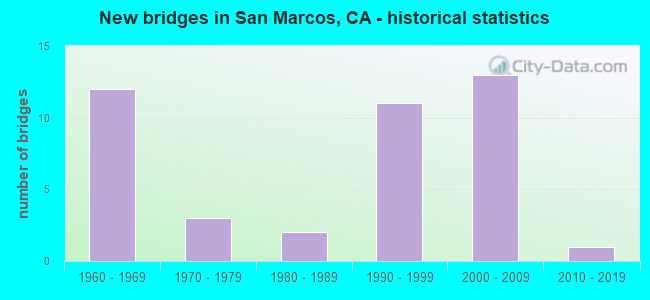
- New bridges - historical statistics
- 121960-1969
- 31970-1979
- 21980-1989
- 111990-1999
- 132000-2009
- 12010-2019

- Reconstructed bridges - Historical Statistics
- 11980-1989
- 11990-1999
- 22000-2009


- Bridge Condition - Deck
- 60.0%Good
- 40.0%Fair

- Bridge Condition - Superstructure
- 87.5%Good
- 12.5%Fair

- Bridge Condition - Substructure
- 93.8%Good
- 6.3%Fair

- Bridge Condition - Channel
- 20.0%Excellent
- 15.0%Very good
- 15.0%Good
- 45.0%Satisfactory
- 5.0%Fair

- Bridge Condition - Culverts
- 78.6%Good
- 14.3%Satisfactory
- 7.1%Poor
Find on map >> Show street view
Structure Number: 57 0135, Location: 11-SD-078-14.99-SMCS (Lat: 33.134739, Lng: -117.128772), Route carried "on" structure: State highway 78, Year Built: 1962, Year Reconstructed: 2013, Status: Open, Structure Length: 10.91m (35.79ft), Average Daily Traffic: 158,000 (year 2012), Truck Traffic: 5%, Average Future Daily Traffic: 218,607 (year 2040), Design Load: HS 20, Features Intersected: MISSION RD,NCTD,BNSF RY
Minimum Vertical Clearance: 30+ m (98+ ft), Kilometerpoint: 14.990, Lanes on structure: 8, Lanes under structure: 4, Base Highway Network: Yes (, Subroute: 1), Owner: State Highway Agency, Approaching Roadway Width: 42.0m (137.8ft), Skew: 35 degrees, Material/Design: Concrete continuous, Design/Construction: Box Beam or Girders - Multiple, Number Of Spans In Main Unit: 4, Length of Maximum Span: 30.5m (100.1ft), Curb-To-Curb Width: 42.0m (137.8ft), Out-to-Out Width: 43.5m (142.7ft)
Condition: Deck: Good, Superstructure: Good, Substructure: Good, Operating Rating: 54.1 metric tons, Method Used To Determine Operating Rating: Assigned rating based on Load Factor Design (LFD) reported in metric tons, Inventory Rating: 32.4 metric tons, Method Used To Determine Inventory Rating: Assigned rating based on Load Factor Design (LFD) reported in metric tons, Structural Evaluation: Better than present minimum criteria, Deck Geometry: Superior to present desirable criteria, Underclear: High priority of corrective action, Approach Roadway Alignment: Equal to present desirable criteria, Designated Inspection Frequency: Every 24 months, Inspection Date: April 2021, Deck Structure Type: Concrete Cast-file-Place, Wearing Surface/Protective System: Wearing Surface: Bituminous
Find on map >> Show street view
Structure Number: 57 0381L, Location: 11-SD-008-17.83-ECJ (Lat: 32.803197, Lng: -116.927631), Route carried "on" structure: Interstate 8, Year Built: 1961, Status: Open, Structure Length: 4.66m (15.29ft), Average Daily Traffic: 48,000 (year 2012), Truck Traffic: 7%, Average Future Daily Traffic: 69,000 (year 2037), Design Load: HS 20, Features Intersected: EAST MAIN STREET
Minimum Vertical Clearance: 30+ m (98+ ft), Kilometerpoint: 17.830, Lanes on structure: 2, Lanes under structure: 5, Base Highway Network: Yes (, Subroute: 1), Owner: State Highway Agency, Approaching Roadway Width: 11.9m (39.0ft), Skew: 9 degrees, Material/Design: Concrete continuous, Design/Construction: Box Beam or Girders - Multiple, Number Of Spans In Main Unit: 2, Length of Maximum Span: 24.1m (79.1ft), Curb-To-Curb Width: 11.9m (39.0ft), Out-to-Out Width: 12.7m (41.7ft)
Condition: Deck: Good, Superstructure: Good, Substructure: Good, Operating Rating: 55.7 metric tons, Method Used To Determine Operating Rating: Load and Resistance Factor Rating (LRFR) rating reported by rating factor(RF) method using HL-93 loadings, Inventory Rating: 40.2 metric tons, Method Used To Determine Inventory Rating: Load and Resistance Factor Rating (LRFR) rating reported by rating factor(RF) method using HL-93 loadings, Structural Evaluation: Better than present minimum criteria, Deck Geometry: Equal to present minimum criteria, Underclear: Meets minimum limits, Approach Roadway Alignment: Equal to present desirable criteria, Designated Inspection Frequency: Every 24 months, Inspection Date: May 2020, Deck Structure Type: Concrete Cast-file-Place
Find on map >> Show street view
Structure Number: 57 0383, Location: 11-SD-078-9.85 (Lat: 33.157931, Lng: -117.207031), Route carried "on" structure: State highway 78, Year Built: 1994, Status: Open, Structure Length: 2.77m (9.09ft), Average Daily Traffic: 137,000 (year 2012), Truck Traffic: 5%, Average Future Daily Traffic: 218,607 (year 2040), Design Load: HS 20+Mod, Features Intersected: SMILAX DRIVE
Minimum Vertical Clearance: 30+ m (98+ ft), Kilometerpoint: 9.850, Lanes on structure: 6, Lanes under structure: 2, Base Highway Network: Yes (, Subroute: 1), Owner: State Highway Agency, Approaching Roadway Width: 34.7m (113.8ft), Skew: 32 degrees, Material/Design: Prestressed concrete, Design/Construction: Stringer/Multi-beam, Number Of Spans In Main Unit: 1, Length of Maximum Span: 27.4m (89.9ft), Curb-To-Curb Width: 34.7m (113.8ft), Out-to-Out Width: 35.8m (117.5ft)
Condition: Deck: Good, Superstructure: Good, Substructure: Good, Operating Rating: 54.1 metric tons, Method Used To Determine Operating Rating: Assigned rating based on Load Factor Design (LFD) reported in metric tons, Inventory Rating: 32.4 metric tons, Method Used To Determine Inventory Rating: Assigned rating based on Load Factor Design (LFD) reported in metric tons, Structural Evaluation: Better than present minimum criteria, Deck Geometry: Superior to present desirable criteria, Underclear: High priority of corrective action, Approach Roadway Alignment: Equal to present desirable criteria, Designated Inspection Frequency: Every 24 months, Inspection Date: April 2021, Deck Structure Type: Concrete Cast-file-Place
Find on map >> Show street view
Structure Number: 57 0384, Location: 11-SD-078-10.61 (Lat: 33.150553, Lng: -117.198200), Route carried "on" structure: County highway S345, Year Built: 1962, Year Reconstructed: 1980, Status: Open, Structure Length: 7.41m (24.31ft), Average Daily Traffic: 30,710 (year 2009), Truck Traffic: 3%, Average Future Daily Traffic: 30,414 (year 2037), Design Load: HS 20, Features Intersected: STATE ROUTE 78, Facility Carried by Structure: RANCHO SANTA FE RD
Minimum Vertical Clearance: 30+ m (98+ ft), Kilometerpoint: 0.000, Lanes on structure: 5, Lanes under structure: 6, Base Highway Network: Yes, Owner: State Highway Agency, Approaching Roadway Width: 21.6m (70.9ft), Skew: 2 degrees, Material/Design: Prestressed concrete continuous, Design/Construction: Box Beam or Girders - Multiple, Number Of Spans In Main Unit: 4, Length of Maximum Span: 22.9m (75.1ft), Curb or Sidewalk Widths: Left: 1.5m (4.9ft), Right: 1.5m (4.9ft), Curb-To-Curb Width: 20.7m (67.9ft), Out-to-Out Width: 25.4m (83.3ft)
Condition: Deck: Good, Superstructure: Good, Substructure: Good, Operating Rating: 54.1 metric tons, Method Used To Determine Operating Rating: Assigned rating based on Load Factor Design (LFD) reported in metric tons, Inventory Rating: 32.4 metric tons, Method Used To Determine Inventory Rating: Assigned rating based on Load Factor Design (LFD) reported in metric tons, Structural Evaluation: Better than present minimum criteria, Deck Geometry: Somewhat better than minimum adequacy, Underclear: Meets minimum limits, Approach Roadway Alignment: Equal to present desirable criteria, Designated Inspection Frequency: Every 48 months, Inspection Date: April 2019, Deck Structure Type: Concrete Cast-file-Place
Find on map >> Show street view
Structure Number: 57 0385, Location: 11-SD-078-11.18-SMCS (Lat: 33.143983, Lng: -117.191064), Route carried "on" structure: State highway 78, Year Built: 1994, Status: Open, Structure Length: 4.75m (15.58ft), Average Daily Traffic: 136,000 (year 2012), Truck Traffic: 5%, Average Future Daily Traffic: 218,607 (year 2040), Design Load: HS 20+Mod, Features Intersected: LAS POSAS RD
Minimum Vertical Clearance: 30+ m (98+ ft), Kilometerpoint: 11.180, Lanes on structure: 6, Lanes under structure: 8, Base Highway Network: Yes (, Subroute: 1), Owner: State Highway Agency, Approaching Roadway Width: 34.7m (113.8ft), Skew: 32 degrees, Material/Design: Prestressed concrete continuous, Design/Construction: Box Beam or Girders - Multiple, Number Of Spans In Main Unit: 2, Length of Maximum Span: 27.4m (89.9ft), Curb-To-Curb Width: 34.7m (113.8ft), Out-to-Out Width: 35.8m (117.5ft)
Condition: Deck: Good, Superstructure: Good, Substructure: Good, Operating Rating: 54.1 metric tons, Method Used To Determine Operating Rating: Assigned rating based on Load Factor Design (LFD) reported in metric tons, Inventory Rating: 32.4 metric tons, Method Used To Determine Inventory Rating: Assigned rating based on Load Factor Design (LFD) reported in metric tons, Structural Evaluation: Better than present minimum criteria, Deck Geometry: Superior to present desirable criteria, Underclear: High priority of corrective action, Approach Roadway Alignment: Superior to present desirable criteria, Designated Inspection Frequency: Every 24 months, Inspection Date: April 2021, Deck Structure Type: Concrete Cast-file-Place
Find on map >> Show street view
Structure Number: 57 0385S, Location: 11-SD-078-11.18-SMCS (Lat: 33.143778, Lng: -117.191186), Route carried "on" structure: Ramp State highway 78, Year Built: 2006, Status: Open, Structure Length: 4.75m (15.58ft), Average Daily Traffic: 9,000 (year 2012), Truck Traffic: 3%, Average Future Daily Traffic: 10,676 (year 2040), Design Load: HS 20+Mod, Features Intersected: LAS POSAS ROAD
Minimum Vertical Clearance: 30+ m (98+ ft), Kilometerpoint: 11.180, Lanes on structure: 1, Lanes under structure: 8, Owner: State Highway Agency, Approaching Roadway Width: 7.3m (24.0ft), Skew: 2 degrees, Material/Design: Prestressed concrete continuous, Design/Construction: Box Beam or Girders - Multiple, Number Of Spans In Main Unit: 2, Length of Maximum Span: 27.7m (90.9ft), Curb-To-Curb Width: 7.3m (24.0ft), Out-to-Out Width: 8.2m (26.9ft)
Condition: Deck: Fair, Superstructure: Good, Substructure: Fair, Operating Rating: 54.1 metric tons, Method Used To Determine Operating Rating: Assigned rating based on Load Factor Design (LFD) reported in metric tons, Inventory Rating: 32.4 metric tons, Method Used To Determine Inventory Rating: Assigned rating based on Load Factor Design (LFD) reported in metric tons, Structural Evaluation: Somewhat better than minimum adequacy, Deck Geometry: Better than present minimum criteria, Underclear: Somewhat better than minimum adequacy, Approach Roadway Alignment: Equal to present desirable criteria, Designated Inspection Frequency: Every 24 months, Inspection Date: April 2021, Deck Structure Type: Concrete Cast-file-Place
Find on map >> Show street view
Structure Number: 57 0387, Location: 11-SD-078-12.13-SMCS (Lat: 33.137850, Lng: -117.176278), Route carried "on" structure: State highway 78, Year Built: 1994, Year Reconstructed: 2000, Status: Open, Structure Length: 7.32m (24.02ft), Average Daily Traffic: 156,000 (year 2012), Truck Traffic: 5%, Average Future Daily Traffic: 218,607 (year 2040), Design Load: HS 20+Mod, Features Intersected: SAN MARCOS BLVD
Minimum Vertical Clearance: 30+ m (98+ ft), Kilometerpoint: 12.130, Lanes on structure: 7, Lanes under structure: 8, Base Highway Network: Yes (, Subroute: 1), Owner: State Highway Agency, Approaching Roadway Width: 40.0m (131.2ft), Skew: 34 degrees, Material/Design: Prestressed concrete, Design/Construction: Stringer/Multi-beam, Number Of Spans In Main Unit: 2, Length of Maximum Span: 39.0m (128.0ft), Curb-To-Curb Width: 39.0m (128.0ft), Out-to-Out Width: 40.0m (131.2ft)
Condition: Deck: Fair, Superstructure: Good, Substructure: Good, Operating Rating: 55.1 metric tons, Method Used To Determine Operating Rating: Load and Resistance Factor Rating (LRFR) rating reported by rating factor(RF) method using HL-93 loadings, Inventory Rating: 16.2 metric tons, Method Used To Determine Inventory Rating: Load and Resistance Factor Rating (LRFR) rating reported by rating factor(RF) method using HL-93 loadings, Structural Evaluation: Meets minimum limits, Deck Geometry: Superior to present desirable criteria, Underclear: Meets minimum limits, Approach Roadway Alignment: Superior to present desirable criteria, Designated Inspection Frequency: Every 24 months, Inspection Date: April 2021, Deck Structure Type: Concrete Cast-file-Place
Find on map >> Show street view
Structure Number: 57 0389, Location: 11-SD-078-14.24-SMCS (Lat: 33.138581, Lng: -117.141328), Route carried "on" structure: State highway 78, Year Built: 1962, Year Reconstructed: 1990, Status: Open, Structure Length: 3.54m (11.61ft), Average Daily Traffic: 138,000 (year 2011), Truck Traffic: 5%, Average Future Daily Traffic: 218,607 (year 2037), Design Load: HS 20, Features Intersected: WOODLAND PARKWAY
Minimum Vertical Clearance: 30+ m (98+ ft), Kilometerpoint: 14.240, Lanes on structure: 7, Lanes under structure: 3, Base Highway Network: Yes (, Subroute: 1), Owner: State Highway Agency, Approaching Roadway Width: 33.5m (109.9ft), Skew: 30 degrees, Material/Design: Concrete continuous, Design/Construction: Slab, Number Of Spans In Main Unit: 3, Length of Maximum Span: 12.8m (42.0ft), Curb-To-Curb Width: 33.5m (109.9ft), Out-to-Out Width: 36.8m (120.7ft)
Condition: Deck: Good, Superstructure: Good, Substructure: Good, Operating Rating: 54.1 metric tons, Method Used To Determine Operating Rating: Assigned rating based on Load Factor Design (LFD) reported in metric tons, Inventory Rating: 32.4 metric tons, Method Used To Determine Inventory Rating: Assigned rating based on Load Factor Design (LFD) reported in metric tons, Structural Evaluation: Better than present minimum criteria, Deck Geometry: Superior to present desirable criteria, Underclear: Meets minimum limits, Approach Roadway Alignment: Equal to present desirable criteria, Designated Inspection Frequency: Every 48 months, Inspection Date: April 2019, Deck Structure Type: Concrete Cast-file-Place, Wearing Surface/Protective System: Wearing Surface: Bituminous
Find on map >> Show street view
Structure Number: 57 0514, Location: 11-SD-078-12.42-SMCS (Lat: 33.136533, Lng: -117.172444), Route carried "on" structure: State highway 78, Year Built: 1962, Status: Open, Structure Length: 2.32m (7.61ft), Average Daily Traffic: 152,000 (year 2009), Truck Traffic: 5%, Average Future Daily Traffic: 163,650 (year 2037), Features Intersected: SAN MARCOS CREEK
Minimum Vertical Clearance: 30+ m (98+ ft), Kilometerpoint: 12.420, Lanes on structure: 8, Base Highway Network: Yes (, Subroute: 1), Owner: State Highway Agency, Approaching Roadway Width: 35.7m (117.1ft), Skew: 24 degrees, Material/Design: Concrete continuous, Design/Construction: Culvert, Number Of Spans In Main Unit: 5, Length of Maximum Span: 3.0m (9.8ft)
Condition: Channel: Very good, Culverts: Good, Operating Rating: 54.1 metric tons, Method Used To Determine Operating Rating: Field evaluation and documented engineering judgment, Inventory Rating: 32.4 metric tons, Method Used To Determine Inventory Rating: Field evaluation and documented engineering judgment, Structural Evaluation: Better than present minimum criteria, Waterway Adequacy: Equal to present desirable criteria, Approach Roadway Alignment: Equal to present desirable criteria, Designated Inspection Frequency: Every 48 months, Inspection Date: April 2019
Find on map >> Show street view
Structure Number: 57C0358, Location: 0.17 MI S/O DEER SPRINGS (Lat: 33.184206, Lng: -117.150442), Route carried "on" structure: County highway , Year Built: 1960, Status: Posted for load, Structure Length: 0.98m (3.22ft), Average Daily Traffic: 1,387 (year 2016), Truck Traffic: 2%, Average Future Daily Traffic: 2,100 (year 2040), Features Intersected: TWIN OAKS VALLEY CREEK, Facility Carried by Structure: SYCAMORE DR
Minimum Vertical Clearance: 30+ m (98+ ft), Kilometerpoint: 0.000, Lanes on structure: 2, Owner: County Highway Agency, Approaching Roadway Width: 8.0m (26.2ft), Skew: 3 degrees, Material/Design: Wood or Timber, Design/Construction: Culvert, Number Of Spans In Main Unit: 3, Length of Maximum Span: 3.0m (9.8ft), Curb or Sidewalk Widths: Left: 0.3m (1.0ft), Right: 0.3m (1.0ft), Curb-To-Curb Width: 8.0m (26.2ft), Out-to-Out Width: 8.5m (27.9ft)
Condition: Channel: Fair, Culverts: Poor, Operating Rating: 14.9 metric tons, Method Used To Determine Operating Rating: Allowable Stress (AS), Inventory Rating: 11.0 metric tons, Method Used To Determine Inventory Rating: Allowable Stress (AS), Structural Evaluation: High priority of replacement, Deck Geometry: Meets minimum limits, Waterway Adequacy: Somewhat better than minimum adequacy, Approach Roadway Alignment: Equal to present minimum criteria, Bridge Posting: Required (Relationship of Operating Rating to Maximum Legal Load: > 39.9% below), Length Of Structure Improvement: 0.98m (3.22ft), Designated Inspection Frequency: Every 12 months, Inspection Date: May 2021, Bridge Improvement Cost: $190,000, Roadway Improvement Cost: $38,000, Total Project Cost: $320,000 ( Estimate for 2017), Deck Structure Type: Wood or Timber, Wearing Surface/Protective System: Wearing Surface: Bituminous
Find on map >> Show street view
Structure Number: 57C045, Location: 0.2 MI WEST OF ROUTE S-6 (Lat: 33.156397, Lng: -117.033461), Route carried "on" structure: City street , Year Built: 1972, Status: Open, Structure Length: 1.68m (5.51ft), Average Daily Traffic: 1,000 (year 2011), Truck Traffic: 1%, Average Future Daily Traffic: 1,119 (year 2036), Design Load: HS 20, Features Intersected: ESCONDIDO CREEK, Facility Carried by Structure: BEVEN DR
Minimum Vertical Clearance: 30+ m (98+ ft), Kilometerpoint: 0.000, Lanes on structure: 2, Owner: City or Municipal Highway Agency, Approaching Roadway Width: 15.2m (49.9ft), Material/Design: Prestressed concrete, Design/Construction: Box Beam or Girders - Multiple, Number Of Spans In Main Unit: 1, Length of Maximum Span: 15.5m (50.9ft), Curb or Sidewalk Widths: Left: 1.8m (5.9ft), Right: 3.3m (10.8ft), Curb-To-Curb Width: 12.3m (40.4ft), Out-to-Out Width: 21.6m (70.9ft)
Condition: Deck: Good, Superstructure: Good, Substructure: Good, Channel: Excellent, Operating Rating: 99.8 metric tons, Method Used To Determine Operating Rating: Load Factor (LF), Inventory Rating: 32.4 metric tons, Method Used To Determine Inventory Rating: Load Factor (LF), Structural Evaluation: Better than present minimum criteria, Deck Geometry: Superior to present desirable criteria, Waterway Adequacy: Superior to present desirable criteria, Approach Roadway Alignment: Equal to present desirable criteria, Designated Inspection Frequency: Every 48 months, Inspection Date: April 2018, Deck Structure Type: Concrete Cast-file-Place, Wearing Surface/Protective System: Wearing Surface: Monolithic Concrete
Find on map >> Show street view
Structure Number: 57C0457, Location: 475 FT N/O W.SAN MARCOS (Lat: 33.142400, Lng: -117.163222), Route carried "on" structure: City street , Year Built: 1977, Status: Open, Structure Length: 6.80m (22.31ft), Average Daily Traffic: 25,600 (year 2019), Truck Traffic: 1%, Average Future Daily Traffic: 26,978 (year 2041), Design Load: HS 20+Mod, Features Intersected: MISSION RD,BNSF RR,NCTD, Facility Carried by Structure: TWIN OAKS VALLEY R
Minimum Vertical Clearance: 30+ m (98+ ft), Kilometerpoint: 0.000, Lanes on structure: 4, Lanes under structure: 4, Owner: City or Municipal Highway Agency, Approaching Roadway Width: 18.3m (60.0ft), Skew: 20 degrees, Material/Design: Concrete continuous, Design/Construction: Tee Beam, Number Of Spans In Main Unit: 3, Number Of Approach Spans: 2, Length of Maximum Span: 19.5m (64.0ft), Curb or Sidewalk Widths: Left: 3.0m (9.8ft), Right: 1.5m (4.9ft), Curb-To-Curb Width: 18.3m (60.0ft), Out-to-Out Width: 24.9m (81.7ft)
Condition: Deck: Good, Superstructure: Good, Substructure: Good, Operating Rating: 66.4 metric tons, Method Used To Determine Operating Rating: Load and Resistance Factor Rating (LRFR) rating reported by rating factor(RF) method using HL-93 loadings, Inventory Rating: 48.9 metric tons, Method Used To Determine Inventory Rating: Load and Resistance Factor Rating (LRFR) rating reported by rating factor(RF) method using HL-93 loadings, Structural Evaluation: Better than present minimum criteria, Deck Geometry: Somewhat better than minimum adequacy, Underclear: Equal to present minimum criteria, Approach Roadway Alignment: Equal to present desirable criteria, Designated Inspection Frequency: Every 48 months, Inspection Date: Febuary 2019, Deck Structure Type: Concrete Cast-file-Place
Find on map >> Show street view
Structure Number: 57C051, Location: 1.2MI N/O DELUZ RD (Lat: 33.413781, Lng: -117.241394), Route carried "on" structure: County highway , Year Built: 1980, Status: Open, Structure Length: 3.23m (10.60ft), Average Daily Traffic: 1,503 (year 2013), Truck Traffic: 2%, Average Future Daily Traffic: 1,625 (year 2040), Features Intersected: SANTA MARGARITA RIVER, Facility Carried by Structure: SANDIA CREEK DR
Minimum Vertical Clearance: 30+ m (98+ ft), Kilometerpoint: 0.000, Lanes on structure: 2, Owner: County Highway Agency, Approaching Roadway Width: 7.9m (25.9ft), Material/Design: Concrete, Design/Construction: Culvert, Number Of Spans In Main Unit: 10, Length of Maximum Span: 3.0m (9.8ft), Curb-To-Curb Width: 8.1m (26.6ft), Out-to-Out Width: 9.1m (29.9ft)
Condition: Channel: Satisfactory, Culverts: Satisfactory, Operating Rating: 54.1 metric tons, Method Used To Determine Operating Rating: Field evaluation and documented engineering judgment, Inventory Rating: 32.4 metric tons, Method Used To Determine Inventory Rating: Field evaluation and documented engineering judgment, Structural Evaluation: Equal to present minimum criteria, Deck Geometry: Meets minimum limits, Waterway Adequacy: Meets minimum limits, Approach Roadway Alignment: Somewhat better than minimum adequacy, Designated Inspection Frequency: Every 48 months, Inspection Date: June 2019, Deck Structure Type: Concrete Cast-file-Place
Find on map >> Show street view
Structure Number: 57C0519, Location: 10 FT W/O SYCAMORE DR (Lat: 33.179658, Lng: -117.152572), Route carried "on" structure: City street , Year Built: 1960, Status: Open, Structure Length: 0.82m (2.69ft), Average Daily Traffic: 2,000 (year 2013), Truck Traffic: 1%, Average Future Daily Traffic: 2,682 (year 2038), Features Intersected: N FORK SAN MARCOS CREEK, Facility Carried by Structure: OLIVE ST
Minimum Vertical Clearance: 30+ m (98+ ft), Kilometerpoint: 0.000, Lanes on structure: 2, Owner: City or Municipal Highway Agency, Approaching Roadway Width: 7.0m (23.0ft), Material/Design: Wood or Timber, Design/Construction: Culvert, Number Of Spans In Main Unit: 3, Length of Maximum Span: 2.4m (7.9ft), Curb-To-Curb Width: 8.4m (27.6ft), Out-to-Out Width: 8.7m (28.5ft)
Condition: Channel: Satisfactory, Culverts: Good, Operating Rating: 51.5 metric tons, Method Used To Determine Operating Rating: Allowable Stress (AS), Inventory Rating: 51.5 metric tons, Method Used To Determine Inventory Rating: Allowable Stress (AS), Structural Evaluation: Better than present minimum criteria, Deck Geometry: Meets minimum limits, Waterway Adequacy: Equal to present minimum criteria, Approach Roadway Alignment: Equal to present desirable criteria, Designated Inspection Frequency: Every 24 months, Inspection Date: Febuary 2021, Deck Structure Type: Wood or Timber, Wearing Surface/Protective System: Wearing Surface: Bituminous
Find on map >> Show street view
Structure Number: 57C0566, Location: 300FT S/O SAN MARCOS BLVD (Lat: 33.130447, Lng: -117.200283), Route carried "on" structure: County highway , Year Built: 1967, Status: Open, Structure Length: 2.62m (8.60ft), Average Daily Traffic: 12,782 (year 2016), Truck Traffic: 2%, Average Future Daily Traffic: 19,272 (year 2038), Design Load: HS 20, Features Intersected: SAN MARCOS CREEK, Facility Carried by Structure: DISCOVERY ST
Minimum Vertical Clearance: 30+ m (98+ ft), Kilometerpoint: 0.000, Lanes on structure: 2, Owner: County Highway Agency, Approaching Roadway Width: 24.0m (78.7ft), Skew: 2 degrees, Material/Design: Concrete continuous, Design/Construction: Slab, Number Of Spans In Main Unit: 3, Length of Maximum Span: 8.5m (27.9ft), Curb-To-Curb Width: 12.0m (39.4ft), Out-to-Out Width: 12.2m (40.0ft)
Condition: Deck: Fair, Superstructure: Fair, Substructure: Good, Channel: Satisfactory, Operating Rating: 62.5 metric tons, Method Used To Determine Operating Rating: Load Factor (LF), Inventory Rating: 37.6 metric tons, Method Used To Determine Inventory Rating: Load Factor (LF), Structural Evaluation: Somewhat better than minimum adequacy, Deck Geometry: Somewhat better than minimum adequacy, Waterway Adequacy: Somewhat better than minimum adequacy, Approach Roadway Alignment: Equal to present desirable criteria, Designated Inspection Frequency: Every 24 months, Inspection Date: May 2021, Deck Structure Type: Concrete Cast-file-Place
Find on map >> Show street view
Structure Number: 57C0692, Location: 500 FT S/O SAN MARCOS BL (Lat: 33.138772, Lng: -117.160503), Route carried "on" structure: City street , Year Built: 1994, Status: Open, Structure Length: 7.86m (25.79ft), Average Daily Traffic: 7,700 (year 2015), Truck Traffic: 2%, Average Future Daily Traffic: 8,114 (year 2038), Design Load: HS 20+Mod, Features Intersected: SAN MARCOS CREEK, Facility Carried by Structure: RANCHEROS DRIVE
Minimum Vertical Clearance: 30+ m (98+ ft), Kilometerpoint: 0.000, Lanes on structure: 2, Owner: City or Municipal Highway Agency, Approaching Roadway Width: 16.0m (52.5ft), Skew: 21 degrees, Material/Design: Concrete continuous, Design/Construction: Box Beam or Girders - Multiple, Number Of Spans In Main Unit: 3, Length of Maximum Span: 33.5m (109.9ft), Curb or Sidewalk Widths: Left: 3.0m (9.8ft), Right: 1.8m (5.9ft), Curb-To-Curb Width: 11.0m (36.1ft), Out-to-Out Width: 20.7m (67.9ft)
Condition: Deck: Fair, Superstructure: Fair, Substructure: Good, Channel: Satisfactory, Operating Rating: 54.1 metric tons, Method Used To Determine Operating Rating: Assigned rating based on Load Factor Design (LFD) reported in metric tons, Inventory Rating: 32.4 metric tons, Method Used To Determine Inventory Rating: Assigned rating based on Load Factor Design (LFD) reported in metric tons, Structural Evaluation: Somewhat better than minimum adequacy, Deck Geometry: Meets minimum limits, Waterway Adequacy: Equal to present desirable criteria, Approach Roadway Alignment: Equal to present desirable criteria, Designated Inspection Frequency: Every 24 months, Inspection Date: Febuary 2021, Deck Structure Type: Concrete Cast-file-Place
Find on map >> Show street view
Structure Number: 57C071, Location: 1.7M S/O I-5 (Lat: 32.553856, Lng: -117.084061), Route carried "on" structure: City street , Year Built: 2000, Status: Open, Structure Length: 8.75m (28.71ft), Average Daily Traffic: 1,279 (year 2016), Truck Traffic: 3%, Average Future Daily Traffic: 1,400 (year 2040), Design Load: HS 20+Mod, Features Intersected: TIJUANA RIVER OVERFLOW, Facility Carried by Structure: HOLLISTER STREET
Minimum Vertical Clearance: 30+ m (98+ ft), Kilometerpoint: 0.000, Lanes on structure: 2, Owner: City or Municipal Highway Agency, Approaching Roadway Width: 10.4m (34.1ft), Skew: 3 degrees, Material/Design: Concrete continuous, Design/Construction: Box Beam or Girders - Multiple, Number Of Spans In Main Unit: 3, Length of Maximum Span: 35.0m (114.8ft), Curb or Sidewalk Widths: Left: 3.0m (9.8ft), Right: 1.8m (5.9ft), Curb-To-Curb Width: 8.5m (27.9ft), Out-to-Out Width: 14.2m (46.6ft)
Condition: Deck: Fair, Superstructure: Good, Substructure: Good, Channel: Excellent, Operating Rating: 54.1 metric tons, Method Used To Determine Operating Rating: Assigned rating based on Load Factor Design (LFD) reported in metric tons, Inventory Rating: 32.4 metric tons, Method Used To Determine Inventory Rating: Assigned rating based on Load Factor Design (LFD) reported in metric tons, Structural Evaluation: Better than present minimum criteria, Deck Geometry: Somewhat better than minimum adequacy, Waterway Adequacy: Equal to present desirable criteria, Approach Roadway Alignment: Equal to present desirable criteria, Designated Inspection Frequency: Every 24 months, Inspection Date: May 2020, Deck Structure Type: Concrete Cast-file-Place
Find on map >> Show street view
Structure Number: 57C0719, Location: 300 FT E/O TWINOAKS VLYRD (Lat: 33.142647, Lng: -117.162044), Route carried "on" structure: City street , Year Built: 1996, Status: Open, Structure Length: 2.70m (8.86ft), Average Daily Traffic: 25,250 (year 2016), Truck Traffic: 1%, Average Future Daily Traffic: 26,609 (year 2038), Features Intersected: N. FORK SAN MARCOS CREEK, Facility Carried by Structure: MISSION RD
Minimum Vertical Clearance: 30+ m (98+ ft), Kilometerpoint: 0.000, Lanes on structure: 4, Owner: City or Municipal Highway Agency, Approaching Roadway Width: 23.5m (77.1ft), Skew: 22 degrees, Material/Design: Concrete continuous, Design/Construction: Culvert, Number Of Spans In Main Unit: 5, Length of Maximum Span: 3.7m (12.1ft)
Condition: Channel: Satisfactory, Culverts: Good, Operating Rating: 54.1 metric tons, Method Used To Determine Operating Rating: Field evaluation and documented engineering judgment, Inventory Rating: 32.4 metric tons, Method Used To Determine Inventory Rating: Field evaluation and documented engineering judgment, Structural Evaluation: Better than present minimum criteria, Waterway Adequacy: Equal to present desirable criteria, Approach Roadway Alignment: Equal to present desirable criteria, Designated Inspection Frequency: Every 48 months, Inspection Date: Febuary 2019
Find on map >> Show street view
Structure Number: 57C0754, Location: 0.25 M W/O SMILAX RD (Lat: 33.159958, Lng: -117.209736), Route carried "on" structure: City street , Year Built: 1961, Status: Open, Structure Length: 0.66m (2.17ft), Average Daily Traffic: 494 (year 2016), Truck Traffic: 1%, Average Future Daily Traffic: 614 (year 2038), Features Intersected: AQUA HEDIONDA CREEK, Facility Carried by Structure: MIMOSA AVE.
Minimum Vertical Clearance: 30+ m (98+ ft), Kilometerpoint: 0.000, Lanes on structure: 2, Owner: County Highway Agency, Approaching Roadway Width: 10.0m (32.8ft), Skew: 5 degrees, Material/Design: Concrete, Design/Construction: Culvert, Number Of Spans In Main Unit: 2, Length of Maximum Span: 1.8m (5.9ft), Curb-To-Curb Width: 10.0m (32.8ft), Out-to-Out Width: 15.0m (49.2ft)
Condition: Channel: Excellent, Culverts: Good, Operating Rating: 40.5 metric tons, Method Used To Determine Operating Rating: Field evaluation and documented engineering judgment, Inventory Rating: 24.3 metric tons, Method Used To Determine Inventory Rating: Field evaluation and documented engineering judgment, Structural Evaluation: Equal to present minimum criteria, Deck Geometry: Equal to present minimum criteria, Waterway Adequacy: Equal to present desirable criteria, Approach Roadway Alignment: Equal to present desirable criteria, Designated Inspection Frequency: Every 24 months, Inspection Date: May 2021
Find on map >> Show street view
Structure Number: 57C077, Location: 750FT S/O OLIVENHAIN RD (Lat: 33.066694, Lng: -117.245036), Route carried "on" structure: City street , Year Built: 2004, Status: Open, Structure Length: 0.93m (3.05ft), Average Daily Traffic: 16,929 (year 2011), Truck Traffic: 1%, Average Future Daily Traffic: 17,500 (year 2040), Features Intersected: ENCINITAS CREEK TRIBUTRY, Facility Carried by Structure: RANCHO SANTA FE RD
Minimum Vertical Clearance: 30+ m (98+ ft), Kilometerpoint: 0.000, Lanes on structure: 4, Owner: City or Municipal Highway Agency, Approaching Roadway Width: 23.3m (76.4ft), Skew: 39 degrees, Material/Design: Concrete continuous, Design/Construction: Culvert, Number Of Spans In Main Unit: 2, Length of Maximum Span: 4.2m (13.8ft)
Condition: Channel: Satisfactory, Culverts: Good, Operating Rating: 54.1 metric tons, Method Used To Determine Operating Rating: Field evaluation and documented engineering judgment, Inventory Rating: 32.4 metric tons, Method Used To Determine Inventory Rating: Field evaluation and documented engineering judgment, Structural Evaluation: Better than present minimum criteria, Waterway Adequacy: Superior to present desirable criteria, Approach Roadway Alignment: Equal to present desirable criteria, Designated Inspection Frequency: Every 48 months, Inspection Date: July 2019
Find on map >> Show street view
Structure Number: 57C0775, Location: 250F E/O TWIN OAKS VLY RD (Lat: 33.173122, Lng: -117.158994), Route carried "on" structure: City street , Year Built: 1992, Status: Open, Structure Length: 1.22m (4.00ft), Average Daily Traffic: 4,300 (year 2019), Truck Traffic: 2%, Average Future Daily Traffic: 4,631 (year 2041), Features Intersected: N. FORK SAN MARCOS CREEK, Facility Carried by Structure: LA CIENEGA ROAD
Minimum Vertical Clearance: 30+ m (98+ ft), Kilometerpoint: 0.000, Lanes on structure: 2, Owner: City or Municipal Highway Agency, Approaching Roadway Width: 13.0m (42.7ft), Material/Design: Concrete continuous, Design/Construction: Culvert, Number Of Spans In Main Unit: 3, Length of Maximum Span: 3.7m (12.1ft), Curb or Sidewalk Widths: Left: 3.3m (10.8ft), Right: 1.7m (5.6ft)
Condition: Channel: Satisfactory, Culverts: Good, Operating Rating: 54.1 metric tons, Method Used To Determine Operating Rating: Field evaluation and documented engineering judgment, Inventory Rating: 32.4 metric tons, Method Used To Determine Inventory Rating: Field evaluation and documented engineering judgment, Structural Evaluation: Better than present minimum criteria, Waterway Adequacy: Equal to present desirable criteria, Approach Roadway Alignment: Equal to present desirable criteria, Designated Inspection Frequency: Every 48 months, Inspection Date: Febuary 2019
Find on map >> Show street view
Structure Number: 57C0777, Location: 750 FT W/O LAS POSAS RD (Lat: 33.149914, Lng: -117.190919), Route carried "on" structure: City street , Year Built: 1982, Status: Open, Structure Length: 0.76m (2.49ft), Average Daily Traffic: 20,160 (year 2015), Truck Traffic: 3%, Average Future Daily Traffic: 23,866 (year 2038), Features Intersected: SAN MARCOS CREEK TRIB, Facility Carried by Structure: MISSION RD
Minimum Vertical Clearance: 30+ m (98+ ft), Kilometerpoint: 0.000, Lanes on structure: 5, Owner: City or Municipal Highway Agency, Approaching Roadway Width: 21.3m (69.9ft), Material/Design: Concrete continuous, Design/Construction: Culvert, Number Of Spans In Main Unit: 3, Length of Maximum Span: 2.4m (7.9ft), Curb or Sidewalk Widths: Left: 3.0m (9.8ft), Right: 1.3m (4.3ft), Curb-To-Curb Width: 21.3m (69.9ft), Out-to-Out Width: 25.6m (84.0ft)
Condition: Channel: Good, Culverts: Good, Operating Rating: 54.1 metric tons, Method Used To Determine Operating Rating: Field evaluation and documented engineering judgment, Inventory Rating: 32.4 metric tons, Method Used To Determine Inventory Rating: Field evaluation and documented engineering judgment, Structural Evaluation: Better than present minimum criteria, Deck Geometry: Somewhat better than minimum adequacy, Waterway Adequacy: Equal to present desirable criteria, Approach Roadway Alignment: Equal to present desirable criteria, Designated Inspection Frequency: Every 48 months, Inspection Date: Febuary 2019
Find on map >> Show street view
Structure Number: 57C0778, Location: 550 FT N/O S.SANTA FE AVE (Lat: 33.158139, Lng: -117.198908), Route carried "on" structure: City street , Year Built: 2004, Status: Open, Structure Length: 5.80m (19.03ft), Average Daily Traffic: 750 (year 2019), Truck Traffic: 2%, Average Future Daily Traffic: 918 (year 2041), Design Load: HS 20, Features Intersected: NCTD RAILROAD, Facility Carried by Structure: LAS FLORES RD
Minimum Vertical Clearance: 30+ m (98+ ft), Kilometerpoint: 0.000, Lanes on structure: 2, Owner: City or Municipal Highway Agency, Approaching Roadway Width: 7.3m (24.0ft), Material/Design: Concrete continuous, Design/Construction: Box Beam or Girders - Multiple, Number Of Spans In Main Unit: 3, Length of Maximum Span: 23.0m (75.5ft), Curb or Sidewalk Widths: Left: 3.0m (9.8ft), Right: 0.0m, Curb-To-Curb Width: 7.3m (24.0ft), Out-to-Out Width: 11.2m (36.7ft)
Condition: Deck: Good, Superstructure: Good, Substructure: Good, Operating Rating: 54.1 metric tons, Method Used To Determine Operating Rating: Assigned rating based on Load Factor Design (LFD) reported in metric tons, Inventory Rating: 32.4 metric tons, Method Used To Determine Inventory Rating: Assigned rating based on Load Factor Design (LFD) reported in metric tons, Structural Evaluation: Better than present minimum criteria, Deck Geometry: Meets minimum limits, Underclear: Meets minimum limits, Approach Roadway Alignment: Better than present minimum criteria, Designated Inspection Frequency: Every 48 months, Inspection Date: Febuary 2019, Deck Structure Type: Concrete Cast-file-Place
Find on map >> Show street view
Structure Number: 57C0779, Location: 275 FT N/O VIA ARTISTA (Lat: 33.166917, Lng: -117.188039), Route carried "on" structure: City street , Year Built: 2003, Status: Open, Structure Length: 4.90m (16.08ft), Average Daily Traffic: 10 (year 2019), Truck Traffic: 3%, Average Future Daily Traffic: 40 (year 2041), Design Load: HS 20, Features Intersected: LAS POSAS CREEK, Facility Carried by Structure: LAS POSAS RD.
Minimum Vertical Clearance: 30+ m (98+ ft), Kilometerpoint: 0.000, Lanes on structure: 4, Owner: City or Municipal Highway Agency, Approaching Roadway Width: 16.0m (52.5ft), Skew: 3 degrees, Material/Design: Steel, Design/Construction: Arch - Deck, Number Of Spans In Main Unit: 1, Length of Maximum Span: 49.0m (160.8ft), Curb or Sidewalk Widths: Left: 1.7m (5.6ft), Right: 3.0m (9.8ft)
Condition: Superstructure: Good, Substructure: Good, Channel: Very good, Operating Rating: 54.1 metric tons, Method Used To Determine Operating Rating: Field evaluation and documented engineering judgment, Inventory Rating: 32.4 metric tons, Method Used To Determine Inventory Rating: Field evaluation and documented engineering judgment, Structural Evaluation: Better than present minimum criteria, Waterway Adequacy: Equal to present desirable criteria, Approach Roadway Alignment: Equal to present desirable criteria, Designated Inspection Frequency: Every 24 months, Inspection Date: Febuary 2021
Find on map >> Show street view
Structure Number: 57C0823, Location: 280FT E/O VALLEY CENTER (Lat: 33.211019, Lng: -117.034731), Route carried "on" structure: Other road , Year Built: 2002, Status: Open, Structure Length: 0.76m (2.49ft), Average Daily Traffic: 800 (year 2013), Truck Traffic: 1%, Average Future Daily Traffic: 1,000 (year 2040), Features Intersected: MOOSA CYN CRK TRIBUTARY, Facility Carried by Structure: MIRAR DEL VALLE RD
Minimum Vertical Clearance: 30+ m (98+ ft), Kilometerpoint: 0.000, Lanes on structure: 2, Owner: County Highway Agency, Approaching Roadway Width: 11.2m (36.7ft), Material/Design: Concrete, Design/Construction: Culvert, Number Of Spans In Main Unit: 3, Length of Maximum Span: 2.4m (7.9ft), Curb or Sidewalk Widths: Left: 0.2m (0.7ft), Right: 0.2m (0.7ft)
Condition: Channel: Good, Culverts: Good, Operating Rating: 54.1 metric tons, Method Used To Determine Operating Rating: Field evaluation and documented engineering judgment, Inventory Rating: 32.4 metric tons, Method Used To Determine Inventory Rating: Field evaluation and documented engineering judgment, Structural Evaluation: Better than present minimum criteria, Waterway Adequacy: Equal to present desirable criteria, Approach Roadway Alignment: Superior to present desirable criteria, Designated Inspection Frequency: Every 48 months, Inspection Date: April 2019
Find on map >> Show street view
Structure Number: 57C0825, Location: 50 FT N/O SR79 RAMPS (Lat: 33.138997, Lng: -117.163822), Route carried "on" structure: City street , Year Built: 2000, Status: Open, Structure Length: 3.15m (10.33ft), Average Daily Traffic: 25,900 (year 2020), Truck Traffic: 3%, Average Future Daily Traffic: 31,100 (year 2042), Design Load: Railroad, Features Intersected: N. BR. SAN MARCOS CREEK, Facility Carried by Structure: TWIN OAKS VLY RD
Minimum Vertical Clearance: 30+ m (98+ ft), Kilometerpoint: 0.000, Lanes on structure: 7, Base Highway Network: Yes, Owner: City or Municipal Highway Agency, Approaching Roadway Width: 24.8m (81.4ft), Skew: 20 degrees, Material/Design: Concrete, Design/Construction: Culvert, Number Of Spans In Main Unit: 10, Length of Maximum Span: 3.4m (11.2ft), Curb or Sidewalk Widths: Left: 1.5m (4.9ft), Right: 1.5m (4.9ft)
Condition: Channel: Satisfactory, Culverts: Good, Operating Rating: 54.1 metric tons, Method Used To Determine Operating Rating: Field evaluation and documented engineering judgment, Inventory Rating: 32.4 metric tons, Method Used To Determine Inventory Rating: Field evaluation and documented engineering judgment, Structural Evaluation: Better than present minimum criteria, Waterway Adequacy: Superior to present desirable criteria, Approach Roadway Alignment: Equal to present desirable criteria, Designated Inspection Frequency: Every 48 months, Inspection Date: Febuary 2021
Find on map >> Show street view
Structure Number: 57C086, Location: 260FT W/O OLD JANA RNCH R (Lat: 32.639536, Lng: -116.944806), Route carried "on" structure: City street , Year Built: 2012, Status: Open, Structure Length: 2.25m (7.38ft), Average Daily Traffic: 10 (year 2016), Truck Traffic: 1%, Average Future Daily Traffic: 15 (year 2036), Design Load: HS 20, Features Intersected: SALT CREEK, Facility Carried by Structure: RAMBLING VISTA RD
Minimum Vertical Clearance: 30+ m (98+ ft), Kilometerpoint: 0.000, Lanes on structure: 2, Owner: City or Municipal Highway Agency, Approaching Roadway Width: 6.1m (20.0ft), Material/Design: Concrete, Design/Construction: Culvert, Number Of Spans In Main Unit: 4, Length of Maximum Span: 5.6m (18.4ft), Curb or Sidewalk Widths: Left: 0.7m (2.3ft), Right: 1.5m (4.9ft), Curb-To-Curb Width: 6.1m (20.0ft), Out-to-Out Width: 9.3m (30.5ft)
Condition: Channel: Excellent, Culverts: Satisfactory, Operating Rating: 54.1 metric tons, Method Used To Determine Operating Rating: Field evaluation and documented engineering judgment, Inventory Rating: 32.4 metric tons, Method Used To Determine Inventory Rating: Field evaluation and documented engineering judgment, Structural Evaluation: Equal to present minimum criteria, Deck Geometry: Somewhat better than minimum adequacy, Waterway Adequacy: Equal to present desirable criteria, Approach Roadway Alignment: Equal to present desirable criteria, Designated Inspection Frequency: Every 48 months, Inspection Date: May 2018
Find on map >> Show street view
Structure Number: 57C0861, Location: 0.2 MI N/O SAN ELIJO RD (Lat: 33.101858, Lng: -117.215361), Route carried "on" structure: City street , Year Built: 2005, Status: Open, Structure Length: 4.18m (13.71ft), Average Daily Traffic: 10,000 (year 2018), Truck Traffic: 5%, Average Future Daily Traffic: 14,000 (year 2040), Design Load: HS 20+Mod, Features Intersected: SAN MARCOS CREEK, Facility Carried by Structure: MELROSE DRIVE
Minimum Vertical Clearance: 30+ m (98+ ft), Kilometerpoint: 0.000, Lanes on structure: 4, Owner: City or Municipal Highway Agency, Approaching Roadway Width: 15.7m (51.5ft), Skew: 9 degrees, Material/Design: Prestressed concrete, Design/Construction: Box Beam or Girders - Multiple, Number Of Spans In Main Unit: 1, Length of Maximum Span: 40.4m (132.5ft), Curb or Sidewalk Widths: Left: 2.4m (7.9ft), Right: 2.4m (7.9ft), Curb-To-Curb Width: 14.3m (46.9ft), Out-to-Out Width: 19.8m (65.0ft)
Condition: Deck: Fair, Superstructure: Good, Substructure: Good, Channel: Good, Operating Rating: 54.1 metric tons, Method Used To Determine Operating Rating: Assigned rating based on Load Factor Design (LFD) reported in metric tons, Inventory Rating: 32.4 metric tons, Method Used To Determine Inventory Rating: Assigned rating based on Load Factor Design (LFD) reported in metric tons, Structural Evaluation: Better than present minimum criteria, Deck Geometry: High priority of replacement, Waterway Adequacy: Equal to present desirable criteria, Approach Roadway Alignment: Equal to present desirable criteria, Designated Inspection Frequency: Every 24 months, Inspection Date: Febuary 2021, Deck Structure Type: Concrete Cast-file-Place
Find on map >> Show street view
Structure Number: 57C0869, Location: AT WB78 RAMPS (Lat: 33.138206, Lng: -117.163800), Route carried "on" structure: City street , Year Built: 1992, Status: Open, Structure Length: 21.82m (71.59ft), Average Daily Traffic: 25,900 (year 2020), Truck Traffic: 3%, Average Future Daily Traffic: 31,100 (year 2042), Design Load: HS 20+Mod, Features Intersected: E. BR. SAN MARCOS CREEK, Facility Carried by Structure: TWIN OAKS VLY ROAD
Minimum Vertical Clearance: 99.00m (324.80ft), Kilometerpoint: 0.000, Lanes on structure: 7, Base Highway Network: Yes, Owner: City or Municipal Highway Agency, Approaching Roadway Width: 24.8m (81.4ft), Skew: 9 degrees, Material/Design: Concrete continuous, Design/Construction: Culvert, Number Of Spans In Main Unit: 5, Length of Maximum Span: 3.4m (11.2ft)
Condition: Channel: Satisfactory, Culverts: Good, Operating Rating: 32.4 metric tons, Method Used To Determine Operating Rating: Field evaluation and documented engineering judgment, Inventory Rating: 32.4 metric tons, Method Used To Determine Inventory Rating: Field evaluation and documented engineering judgment, Structural Evaluation: Better than present minimum criteria, Waterway Adequacy: Equal to present desirable criteria, Approach Roadway Alignment: Equal to present desirable criteria, Designated Inspection Frequency: Every 48 months, Inspection Date: Febuary 2021
Find on map >> Show street view
Structure Number: 57C087, Location: 150 FT E/O TWIN OAKS VLY (Lat: 33.141042, Lng: -117.163381), Route carried "on" structure: Business City street , Year Built: 1999, Status: Open, Structure Length: 3.20m (10.50ft), Average Daily Traffic: 12,000 (year 2018), Truck Traffic: 2%, Average Future Daily Traffic: 15,000 (year 2040), Features Intersected: N. BR. SAN MARCOS CREEK, Facility Carried by Structure: SAN MARCOS BLVD
Minimum Vertical Clearance: 30+ m (98+ ft), Kilometerpoint: 0.000, Lanes on structure: 6, Owner: City or Municipal Highway Agency, Approaching Roadway Width: 24.0m (78.7ft), Material/Design: Concrete continuous, Design/Construction: Culvert, Number Of Spans In Main Unit: 5, Length of Maximum Span: 3.6m (11.8ft), Curb or Sidewalk Widths: Left: 1.5m (4.9ft), Right: 1.5m (4.9ft)
Condition: Channel: Very good, Culverts: Good, Operating Rating: 54.1 metric tons, Method Used To Determine Operating Rating: Field evaluation and documented engineering judgment, Inventory Rating: 32.4 metric tons, Method Used To Determine Inventory Rating: Field evaluation and documented engineering judgment, Structural Evaluation: Better than present minimum criteria, Waterway Adequacy: Equal to present desirable criteria, Approach Roadway Alignment: Equal to present desirable criteria, Designated Inspection Frequency: Every 48 months, Inspection Date: Febuary 2019
Find on map >> Show street view
Structure Number: 57 0135, Location: 11-SD-078-14.99-SMCS (Lat: 33.134739, Lng: -117.128772), Route carried "under" structure: City street S142, Year Built: 1962, Structure Length: 0. m, Average Daily Traffic: 18,300 (year 2012), Truck Traffic: 1%, Features Intersected: MISSION RD,NCTD,BNSF RY, Facility Carried by Structure: STATE ROUTE 78
Minimum Vertical Clearance: 5.89m (19.32ft), Kilometerpoint: 0.000, Lanes on structure: 8, Lanes under structure: 4, Material/Design: Concrete continuous, Design/Construction: Box Beam or Girders - Multiple, Length of Maximum Span: 30.5m (100.1ft)
Find on map >> Show street view
Structure Number: 57 0383, Location: 11-SD-078-9.85 (Lat: 33.157931, Lng: -117.207031), Route carried "under" structure: City street , Year Built: 1994, Structure Length: 0. m, Average Daily Traffic: 3,160 (year 2012), Truck Traffic: 1%, Features Intersected: SMILAX DRIVE, Facility Carried by Structure: STATE ROUTE 78
Minimum Vertical Clearance: 4.60m (15.09ft), Kilometerpoint: 9.850, Lanes on structure: 6, Lanes under structure: 2, Material/Design: Prestressed concrete, Design/Construction: Stringer/Multi-beam, Length of Maximum Span: 27.4m (89.9ft)
Find on map >> Show street view
Structure Number: 57 0384, Location: 11-SD-078-10.61 (Lat: 33.150553, Lng: -117.198200), Route carried "under" structure: State highway 78, Year Built: 1962, Structure Length: 0. m, Average Daily Traffic: 136,000 (year 2011), Truck Traffic: 5%, Features Intersected: STATE ROUTE 78, Facility Carried by Structure: RANCHO SANTA FE RD
Minimum Vertical Clearance: 5.11m (16.77ft), Kilometerpoint: 10.610, Lanes on structure: 5, Lanes under structure: 6, Material/Design: Prestressed concrete continuous, Design/Construction: Box Beam or Girders - Multiple, Length of Maximum Span: 22.9m (75.1ft)
Find on map >> Show street view
Structure Number: 57 0385, Location: 11-SD-078-11.18-SMCS (Lat: 33.143983, Lng: -117.191064), Route carried "under" structure: City street S438, Year Built: 1994, Structure Length: 0. m, Average Daily Traffic: 8,040 (year 2012), Truck Traffic: 1%, Features Intersected: LAS POSAS RD, Facility Carried by Structure: STATE ROUTE 78
Minimum Vertical Clearance: 5.15m (16.90ft), Kilometerpoint: 0.000, Lanes on structure: 6, Lanes under structure: 8, Material/Design: Prestressed concrete continuous, Design/Construction: Box Beam or Girders - Multiple, Length of Maximum Span: 27.4m (89.9ft)
Find on map >> Show street view
Structure Number: 57 0385S, Location: 11-SD-078-11.18-SMCS (Lat: 33.143778, Lng: -117.191186), Route carried "under" structure: Other road , Year Built: 2006, Structure Length: 0. m, Average Daily Traffic: 8,040 (year 2012), Truck Traffic: 1%, Features Intersected: LAS POSAS ROAD, Facility Carried by Structure: E78-GRAND AVE OFF
Minimum Vertical Clearance: 5.05m (16.57ft), Kilometerpoint: 0.000, Lanes on structure: 1, Lanes under structure: 8, Material/Design: Prestressed concrete continuous, Design/Construction: Box Beam or Girders - Multiple, Length of Maximum Span: 27.7m (90.9ft)
Find on map >> Show street view
Structure Number: 57 0387, Location: 11-SD-078-12.13-SMCS (Lat: 33.137850, Lng: -117.176278), Route carried "under" structure: City street S150, Year Built: 1994, Structure Length: 0. m, Average Daily Traffic: 41,256 (year 2012), Truck Traffic: 3%, Features Intersected: SAN MARCOS BLVD, Facility Carried by Structure: STATE ROUTE 78
Minimum Vertical Clearance: 4.62m (15.16ft), Kilometerpoint: 0.000, Lanes on structure: 7, Lanes under structure: 8, Material/Design: Prestressed concrete, Design/Construction: Stringer/Multi-beam, Length of Maximum Span: 39.0m (128.0ft)
Find on map >> Show street view
Structure Number: 57 0389, Location: 11-SD-078-14.24-SMCS (Lat: 33.138581, Lng: -117.141328), Route carried "under" structure: City street , Year Built: 1962, Structure Length: 0. m, Average Daily Traffic: 1,600 (year 2009), Truck Traffic: 4%, Features Intersected: WOODLAND PARKWAY, Facility Carried by Structure: STATE ROUTE 78
Minimum Vertical Clearance: 5.13m (16.83ft), Kilometerpoint: 0.000, Lanes on structure: 7, Lanes under structure: 3, Material/Design: Concrete continuous, Design/Construction: Slab, Length of Maximum Span: 12.8m (42.0ft)
Find on map >> Show street view
Structure Number: 57 1105, Location: 11-SD-078-13.27 (Lat: 33.138603, Lng: -117.157733), Route carried "under" structure: State highway 78, Year Built: 2008, Structure Length: 0. m, Average Daily Traffic: 160,000 (year 2011), Truck Traffic: 4%, Features Intersected: STATE HIGHWAY 78, Facility Carried by Structure: MCTD LRT & SDIV RR
Minimum Vertical Clearance: 5.84m (19.16ft), Kilometerpoint: 13.270, Lanes under structure: 8, Material/Design: Prestressed concrete continuous, Design/Construction: Box Beam or Girders - Multiple, Length of Maximum Span: 30.0m (98.4ft)
Find on map >> Show street view
Structure Number: 57 1106, Location: 11-SD-078-14.26-SMCS (Lat: 33.139539, Lng: -117.138975), Route carried "under" structure: State highway 78, Year Built: 2008, Structure Length: 0. m, Average Daily Traffic: 158,000 (year 2011), Truck Traffic: 4%, Features Intersected: STATE HIGHWAY 78, Facility Carried by Structure: MCTD LRT & SDIV RR
Minimum Vertical Clearance: 6.02m (19.75ft), Kilometerpoint: 14.260, Lanes under structure: 6, Material/Design: Prestressed concrete continuous, Design/Construction: Box Beam or Girders - Multiple, Length of Maximum Span: 45.4m (149.0ft)
Find on map >> Show street view
Structure Number: 57C0457, Location: 475 FT N/O W.SAN MARCOS (Lat: 33.142400, Lng: -117.163222), Route carried "under" structure: City street , Year Built: 1977, Structure Length: 0. m, Average Daily Traffic: 11,900 (year 2019), Truck Traffic: 2%, Features Intersected: MISSION RD,BNSF RR,NCTD, Facility Carried by Structure: TWIN OAKS VALLEY R
Minimum Vertical Clearance: 5.87m (19.26ft), Kilometerpoint: 0.000, Lanes on structure: 4, Lanes under structure: 4, Material/Design: Concrete continuous, Design/Construction: Tee Beam, Length of Maximum Span: 19.5m (64.0ft)
Find on map >> Show street view
Structure Number: 57C0826, Location: 60FT S/O BARHAM DR (Lat: 33.134700, Lng: -117.153711), Route carried "under" structure: City street , Year Built: 2008, Structure Length: 0. m, Average Daily Traffic: 4,100 (year 2015), Truck Traffic: 1%, Features Intersected: LA MOREE ROAD, Facility Carried by Structure: NCTD LRT
Minimum Vertical Clearance: 5.16m (16.93ft), Kilometerpoint: 0.000, Lanes under structure: 5, Material/Design: Concrete continuous, Design/Construction: Box Beam or Girders - Multiple, Length of Maximum Span: 35.0m (114.8ft)
Find on map >> Show street view
Structure Number: 57C0827, Location: 0.52MI E/O TWIN OAKS VLY (Lat: 33.134514, Lng: -117.155625), Route carried "under" structure: City street , Year Built: 2008, Structure Length: 0. m, Average Daily Traffic: 12,200 (year 2015), Truck Traffic: 2%, Features Intersected: BARHAM DRIVE, Facility Carried by Structure: NCTD LRT
Minimum Vertical Clearance: 4.90m (16.08ft), Kilometerpoint: 0.000, Lanes under structure: 5, Material/Design: Concrete continuous, Design/Construction: Box Beam or Girders - Multiple, Length of Maximum Span: 43.0m (141.1ft)