Bridge Statistics for Sonoma, California (CA)
Condition, Traffic, Stress, Structural Evaluation, Project Costs
- National Bridge Inventory (NBI) Statistics
- 15Number of bridges
- 105ft / 32.4mTotal length
- $618,000Total costs
- 75,178Total average daily traffic
- 3,293Total average daily truck traffic
- 100,166Total future (year 2036) average daily traffic
- National Bridge Inventory (NBI) Registered Bridges for Sonoma
- No street view available for this location
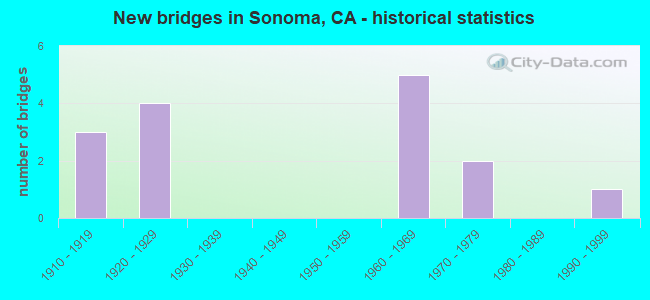
- New bridges - historical statistics
- 31910-1919
- 41920-1929
- 51960-1969
- 21970-1979
- 11990-1999

- Reconstructed bridges - Historical Statistics
- 11960-1969
- 11970-1979
- 01980-1989
- 11990-1999


- Bridge Condition - Deck
- 58.3%Good
- 41.7%Fair

- Bridge Condition - Superstructure
- 38.5%Good
- 61.5%Fair

- Bridge Condition - Substructure
- 46.2%Good
- 7.7%Satisfactory
- 38.5%Fair
- 7.7%Poor

- Bridge Condition - Channel
- 6.7%Excellent
- 20.0%Very good
- 33.3%Good
- 40.0%Satisfactory
Find on map >> Show street view
Structure Number: 20 0023, Location: 04-SON-121-8.43 (Lat: 38.246128, Lng: -122.435275), Route carried "on" structure: State highway 121, Year Built: 1923, Year Reconstructed: 1967, Status: Open, Structure Length: 2.50m (8.20ft), Average Daily Traffic: 19,000 (year 2016), Truck Traffic: 7%, Average Future Daily Traffic: 27,000 (year 2038), Design Load: HS 15, Features Intersected: ARROYO SECO
Minimum Vertical Clearance: 30+ m (98+ ft), Kilometerpoint: 8.430, Lanes on structure: 2, Base Highway Network: Yes (Inventory Route: 1, Subroute: 1), Owner: State Highway Agency, Approaching Roadway Width: 7.3m (24.0ft), Skew: 3 degrees, Material/Design: Concrete continuous, Design/Construction: Tee Beam, Number Of Spans In Main Unit: 2, Length of Maximum Span: 12.2m (40.0ft), Curb-To-Curb Width: 7.5m (24.6ft), Out-to-Out Width: 7.7m (25.3ft)
Condition: Deck: Fair, Superstructure: Good, Substructure: Fair, Channel: Satisfactory, Operating Rating: 62.2 metric tons, Method Used To Determine Operating Rating: Load Factor (LF), Inventory Rating: 37.6 metric tons, Method Used To Determine Inventory Rating: Load Factor (LF), Structural Evaluation: Somewhat better than minimum adequacy, Deck Geometry: High priority of replacement, Waterway Adequacy: High priority of corrective action, Approach Roadway Alignment: Better than present minimum criteria, Designated Inspection Frequency: Every 24 months, Inspection Date: October 2020, Deck Structure Type: Concrete Cast-file-Place, Wearing Surface/Protective System: Wearing Surface: Bituminous
Find on map >> Show street view
Structure Number: 20 0121, Location: 04-SON-121-8.51 (Lat: 38.246181, Lng: -122.432700), Route carried "on" structure: State highway 121, Year Built: 1922, Status: Open, Structure Length: 0.67m (2.20ft), Average Daily Traffic: 19,000 (year 2014), Truck Traffic: 7%, Average Future Daily Traffic: 27,000 (year 2037), Features Intersected: BRANCH ARROYO SECO
Minimum Vertical Clearance: 30+ m (98+ ft), Kilometerpoint: 8.510, Lanes on structure: 2, Base Highway Network: Yes (Inventory Route: 1, Subroute: 1), Owner: State Highway Agency, Approaching Roadway Width: 9.2m (30.2ft), Skew: 3 degrees, Material/Design: Concrete, Design/Construction: Slab, Number Of Spans In Main Unit: 1, Length of Maximum Span: 6.1m (20.0ft), Curb-To-Curb Width: 8.2m (26.9ft), Out-to-Out Width: 8.2m (26.9ft)
Condition: Deck: Good, Superstructure: Good, Substructure: Good, Channel: Satisfactory, Operating Rating: 40.5 metric tons, Method Used To Determine Operating Rating: Field evaluation and documented engineering judgment, Inventory Rating: 24.3 metric tons, Method Used To Determine Inventory Rating: Field evaluation and documented engineering judgment, Structural Evaluation: Equal to present minimum criteria, Deck Geometry: High priority of replacement, Waterway Adequacy: High priority of corrective action, Approach Roadway Alignment: Equal to present desirable criteria, Designated Inspection Frequency: Every 24 months, Inspection Date: October 2020
Find on map >> Show street view
Structure Number: 20C0017, Location: 0.3 MI WEST OF SR 12 (Lat: 38.265686, Lng: -122.467572), Route carried "on" structure: County highway , Year Built: 1929, Status: Posted for load, Structure Length: 5.18m (16.99ft), Average Daily Traffic: 3,628 (year 2016), Truck Traffic: 1%, Average Future Daily Traffic: 2,095 (year 2040), Design Load: H 15, Features Intersected: SONOMA CREEK, Facility Carried by Structure: WATMAUGH ROAD
Minimum Vertical Clearance: 30+ m (98+ ft), Kilometerpoint: 0.000, Lanes on structure: 2, Owner: County Highway Agency, Approaching Roadway Width: 5.8m (19.0ft), Skew: 1 degrees, Material/Design: Steel, Design/Construction: Truss - Thru, Number Of Spans In Main Unit: 1, Number Of Approach Spans: 2, Length of Maximum Span: 31.4m (103.0ft), Curb-To-Curb Width: 6.8m (22.3ft), Out-to-Out Width: 7.2m (23.6ft)
Condition: Deck: Good, Superstructure: Fair, Substructure: Fair, Channel: Satisfactory, Operating Rating: 22.0 metric tons, Method Used To Determine Operating Rating: Load Factor (LF), Inventory Rating: 13.3 metric tons, Method Used To Determine Inventory Rating: Load Factor (LF), Structural Evaluation: Meets minimum limits, Deck Geometry: High priority of replacement, Waterway Adequacy: Equal to present minimum criteria, Approach Roadway Alignment: High priority of corrective action, Bridge Posting: Required (Relationship of Operating Rating to Maximum Legal Load: 10.0 - 19.9% below), Designated Inspection Frequency: Every 24 months, Critical Feature Inspection Frequency: Every 24 months, Inspection Date: April 2020, Critical Feature Inspection Date: April 2020, Deck Structure Type: Concrete Cast-file-Place, Wearing Surface/Protective System: Wearing Surface: Bituminous
Find on map >> Show street view
Structure Number: 20C0171, Location: 0.65 MI W JCT WITH SR 12 (Lat: 38.277333, Lng: -122.472253), Route carried "on" structure: County highway , Year Built: 1969, Status: Open, Structure Length: 7.08m (23.23ft), Average Daily Traffic: 10,400 (year 2015), Truck Traffic: 2%, Average Future Daily Traffic: 4,233 (year 2036), Design Load: HS 20+Mod, Features Intersected: SONOMA CREEK, Facility Carried by Structure: LEVERONI RD
Minimum Vertical Clearance: 30+ m (98+ ft), Kilometerpoint: 0.000, Lanes on structure: 2, Owner: County Highway Agency, Approaching Roadway Width: 12.0m (39.4ft), Skew: 4 degrees, Material/Design: Concrete continuous, Design/Construction: Box Beam or Girders - Multiple, Number Of Spans In Main Unit: 3, Length of Maximum Span: 27.7m (90.9ft), Curb or Sidewalk Widths: Left: 0.1m (0.3ft), Right: 0.1m (0.3ft), Curb-To-Curb Width: 12.0m (39.4ft), Out-to-Out Width: 12.2m (40.0ft)
Condition: Deck: Good, Superstructure: Good, Substructure: Good, Channel: Good, Operating Rating: 57.0 metric tons, Method Used To Determine Operating Rating: Load and Resistance Factor Rating (LRFR) rating reported by rating factor(RF) method using HL-93 loadings, Inventory Rating: 40.8 metric tons, Method Used To Determine Inventory Rating: Load and Resistance Factor Rating (LRFR) rating reported by rating factor(RF) method using HL-93 loadings, Structural Evaluation: Better than present minimum criteria, Deck Geometry: Somewhat better than minimum adequacy, Waterway Adequacy: Equal to present desirable criteria, Approach Roadway Alignment: Equal to present desirable criteria, Designated Inspection Frequency: Every 48 months, Inspection Date: October 2018, Deck Structure Type: Concrete Cast-file-Place
Find on map >> Show street view
Structure Number: 20C0209, Location: 1.05 MI W OF SR 12 (Lat: 38.275989, Lng: -122.477967), Route carried "on" structure: County highway , Year Built: 1972, Status: Open, Structure Length: 2.53m (8.30ft), Average Daily Traffic: 6,000 (year 2015), Truck Traffic: 2%, Average Future Daily Traffic: 7,524 (year 2040), Design Load: HS 20, Features Intersected: CARRIGER CREEK, Facility Carried by Structure: LEVERONI RD
Minimum Vertical Clearance: 30+ m (98+ ft), Kilometerpoint: 0.000, Lanes on structure: 2, Owner: County Highway Agency, Approaching Roadway Width: 10.7m (35.1ft), Skew: 2 degrees, Material/Design: Concrete continuous, Design/Construction: Slab, Number Of Spans In Main Unit: 3, Length of Maximum Span: 9.8m (32.2ft), Curb-To-Curb Width: 10.8m (35.4ft), Out-to-Out Width: 11.0m (36.1ft)
Condition: Deck: Fair, Superstructure: Fair, Substructure: Satisfactory, Channel: Good, Operating Rating: 60.6 metric tons, Method Used To Determine Operating Rating: Load Factor (LF), Inventory Rating: 36.6 metric tons, Method Used To Determine Inventory Rating: Load Factor (LF), Structural Evaluation: Somewhat better than minimum adequacy, Deck Geometry: Meets minimum limits, Waterway Adequacy: Better than present minimum criteria, Approach Roadway Alignment: Equal to present desirable criteria, Designated Inspection Frequency: Every 24 months, Inspection Date: May 2021, Deck Structure Type: Concrete Cast-file-Place
Find on map >> Show street view
Structure Number: 20C0253, Location: 0.25 MILE NORTH OF RT 12 (Lat: 38.250019, Lng: -122.440594), Route carried "on" structure: County highway , Year Built: 1968, Status: Open, Structure Length: 2.97m (9.74ft), Average Daily Traffic: 1,500 (year 2018), Truck Traffic: 6%, Average Future Daily Traffic: 2,100 (year 2041), Design Load: HS 20, Features Intersected: SCHELL CREEK, Facility Carried by Structure: 8TH ST EAST
Minimum Vertical Clearance: 30+ m (98+ ft), Kilometerpoint: 0.000, Lanes on structure: 2, Owner: County Highway Agency, Approaching Roadway Width: 7.0m (23.0ft), Skew: 3 degrees, Material/Design: Concrete continuous, Design/Construction: Slab, Number Of Spans In Main Unit: 3, Length of Maximum Span: 11.7m (38.4ft), Curb-To-Curb Width: 12.2m (40.0ft), Out-to-Out Width: 12.4m (40.7ft)
Condition: Deck: Fair, Superstructure: Fair, Substructure: Poor, Channel: Good, Operating Rating: 58.0 metric tons, Method Used To Determine Operating Rating: Load Factor (LF), Inventory Rating: 35.0 metric tons, Method Used To Determine Inventory Rating: Load Factor (LF), Structural Evaluation: Meets minimum limits, Deck Geometry: Better than present minimum criteria, Waterway Adequacy: Equal to present desirable criteria, Approach Roadway Alignment: Equal to present minimum criteria, Length Of Structure Improvement: 2.99m (9.81ft), Designated Inspection Frequency: Every 24 months, Inspection Date: Febuary 2021, Bridge Improvement Cost: $368,000, Roadway Improvement Cost: $73,000, Total Project Cost: $618,000 ( Estimate for 2019), Deck Structure Type: Concrete Cast-file-Place
Find on map >> Show street view
Structure Number: 20C0254, Location: JUST EAST OF SR 12 (Lat: 38.255286, Lng: -122.450958), Route carried "on" structure: County highway , Year Built: 1970, Status: Open, Structure Length: 0.98m (3.22ft), Average Daily Traffic: 100 (year 2015), Average Future Daily Traffic: 157 (year 2040), Features Intersected: SCHELL CREEK, Facility Carried by Structure: SAN LUIS ROAD
Minimum Vertical Clearance: 30+ m (98+ ft), Kilometerpoint: 0.000, Lanes on structure: 2, Owner: County Highway Agency, Approaching Roadway Width: 6.7m (22.0ft), Material/Design: Steel, Design/Construction: Stringer/Multi-beam, Number Of Spans In Main Unit: 1, Length of Maximum Span: 9.1m (29.9ft), Curb-To-Curb Width: 9.8m (32.2ft), Out-to-Out Width: 10.0m (32.8ft)
Condition: Deck: Good, Superstructure: Good, Substructure: Fair, Channel: Excellent, Operating Rating: 28.8 metric tons, Method Used To Determine Operating Rating: Load Factor (LF), Inventory Rating: 17.2 metric tons, Method Used To Determine Inventory Rating: Load Factor (LF), Structural Evaluation: Somewhat better than minimum adequacy, Deck Geometry: Equal to present desirable criteria, Waterway Adequacy: Equal to present desirable criteria, Approach Roadway Alignment: Equal to present desirable criteria, Designated Inspection Frequency: Every 24 months, Inspection Date: April 2020, Deck Structure Type: Concrete Cast-file-Place
Find on map >> Show street view
Structure Number: 20C0255, Location: 0.5 MI E SR 12 (Lat: 38.264536, Lng: -122.453258), Route carried "on" structure: County highway , Year Built: 1920, Year Reconstructed: 1970, Status: Open, Structure Length: 1.04m (3.41ft), Average Daily Traffic: 1,000 (year 2015), Truck Traffic: 1%, Average Future Daily Traffic: 3,000 (year 2040), Features Intersected: NATHANSON CREEK, Facility Carried by Structure: WATMAUGH ROAD
Minimum Vertical Clearance: 30+ m (98+ ft), Kilometerpoint: 0.000, Lanes on structure: 2, Owner: County Highway Agency, Approaching Roadway Width: 4.9m (16.1ft), Skew: 3 degrees, Material/Design: Concrete, Design/Construction: Tee Beam, Number Of Spans In Main Unit: 1, Length of Maximum Span: 10.1m (33.1ft), Curb-To-Curb Width: 10.0m (32.8ft), Out-to-Out Width: 10.2m (33.5ft)
Condition: Deck: Good, Superstructure: Good, Substructure: Fair, Channel: Satisfactory, Operating Rating: 25.9 metric tons, Method Used To Determine Operating Rating: Field evaluation and documented engineering judgment, Inventory Rating: 15.6 metric tons, Method Used To Determine Inventory Rating: Field evaluation and documented engineering judgment, Structural Evaluation: Meets minimum limits, Deck Geometry: Equal to present minimum criteria, Waterway Adequacy: Better than present minimum criteria, Approach Roadway Alignment: Equal to present desirable criteria, Designated Inspection Frequency: Every 24 months, Inspection Date: April 2020, Deck Structure Type: Concrete Cast-file-Place, Wearing Surface/Protective System: Wearing Surface: Bituminous
Find on map >> Show street view
Structure Number: 20C042, Location: 0.2 MI N/O WEST 3RD ST (Lat: 38.436708, Lng: -122.724492), Route carried "on" structure: City street , Year Built: 1960, Status: Open, Structure Length: 3.08m (10.10ft), Average Daily Traffic: 500 (year 2018), Truck Traffic: 1%, Average Future Daily Traffic: 313 (year 2041), Features Intersected: SANTA ROSA CREEK, Facility Carried by Structure: PIERSON ST
Minimum Vertical Clearance: 30+ m (98+ ft), Kilometerpoint: 0.000, Lanes on structure: 2, Owner: City or Municipal Highway Agency, Approaching Roadway Width: 7.3m (24.0ft), Material/Design: Concrete continuous, Design/Construction: Slab, Number Of Spans In Main Unit: 3, Length of Maximum Span: 10.7m (35.1ft), Curb or Sidewalk Widths: Left: 0.0m, Right: 1.5m (4.9ft), Curb-To-Curb Width: 8.6m (28.2ft), Out-to-Out Width: 10.9m (35.8ft)
Condition: Deck: Fair, Superstructure: Fair, Substructure: Good, Channel: Very good, Operating Rating: 63.8 metric tons, Method Used To Determine Operating Rating: Load Factor (LF), Inventory Rating: 38.2 metric tons, Method Used To Determine Inventory Rating: Load Factor (LF), Structural Evaluation: Somewhat better than minimum adequacy, Deck Geometry: Somewhat better than minimum adequacy, Waterway Adequacy: Equal to present desirable criteria, Approach Roadway Alignment: Equal to present minimum criteria, Designated Inspection Frequency: Every 24 months, Inspection Date: June 2020, Deck Structure Type: Concrete Cast-file-Place
Find on map >> Show street view
Structure Number: 20C0422, Location: AUSTIN AVE (Lat: 38.284475, Lng: -122.456719), Route carried "on" structure: County highway , Year Built: 1965, Status: Open, Structure Length: 0.86m (2.82ft), Average Daily Traffic: 2,000 (year 2015), Truck Traffic: 2%, Average Future Daily Traffic: 3,184 (year 2038), Features Intersected: NATHANSON CREEK, Facility Carried by Structure: MACARTHUR STREET
Minimum Vertical Clearance: 30+ m (98+ ft), Kilometerpoint: 0.000, Lanes on structure: 2, Owner: City or Municipal Highway Agency, Approaching Roadway Width: 12.2m (40.0ft), Skew: 1 degrees, Material/Design: Concrete, Design/Construction: Slab, Number Of Spans In Main Unit: 1, Length of Maximum Span: 8.2m (26.9ft), Curb or Sidewalk Widths: Left: 1.2m (3.9ft), Right: 1.2m (3.9ft), Curb-To-Curb Width: 12.2m (40.0ft), Out-to-Out Width: 15.3m (50.2ft)
Condition: Deck: Fair, Superstructure: Fair, Substructure: Good, Channel: Good, Operating Rating: 36.9 metric tons, Method Used To Determine Operating Rating: Field evaluation and documented engineering judgment, Inventory Rating: 22.4 metric tons, Method Used To Determine Inventory Rating: Field evaluation and documented engineering judgment, Structural Evaluation: Somewhat better than minimum adequacy, Deck Geometry: Better than present minimum criteria, Waterway Adequacy: Equal to present desirable criteria, Approach Roadway Alignment: Better than present minimum criteria, Designated Inspection Frequency: Every 24 months, Inspection Date: June 2021, Deck Structure Type: Concrete Cast-file-Place, Wearing Surface/Protective System: Wearing Surface: Bituminous
Find on map >> Show street view
Structure Number: 20C0458, Location: 0.4 MI S JCT NAPA RD (Lat: 38.265703, Lng: -122.429378), Route carried "on" structure: County highway , Year Built: 1965, Status: Open, Structure Length: 0.79m (2.59ft), Average Daily Traffic: 400 (year 2015), Truck Traffic: 2%, Average Future Daily Traffic: 448 (year 2040), Features Intersected: ARROYO SECO, Facility Carried by Structure: HYDE ROAD
Minimum Vertical Clearance: 30+ m (98+ ft), Kilometerpoint: 0.000, Lanes on structure: 2, Owner: County Highway Agency, Approaching Roadway Width: 7.0m (23.0ft), Material/Design: Concrete continuous, Design/Construction: Culvert, Number Of Spans In Main Unit: 2, Length of Maximum Span: 3.7m (12.1ft)
Condition: Channel: Satisfactory, Culverts: Satisfactory, Operating Rating: 40.5 metric tons, Method Used To Determine Operating Rating: Field evaluation and documented engineering judgment, Inventory Rating: 24.3 metric tons, Method Used To Determine Inventory Rating: Field evaluation and documented engineering judgment, Structural Evaluation: Equal to present minimum criteria, Waterway Adequacy: Better than present minimum criteria, Approach Roadway Alignment: Equal to present minimum criteria, Designated Inspection Frequency: Every 24 months, Inspection Date: May 2021
Find on map >> Show street view
Structure Number: 20C0491, Location: 0.1 MI E STONY PT RD (Lat: 38.353050, Lng: -122.739086), Route carried "on" structure: County highway , Year Built: 1990, Status: Open, Structure Length: 1.95m (6.40ft), Average Daily Traffic: 8,200 (year 2015), Truck Traffic: 1%, Average Future Daily Traffic: 17,274 (year 2040), Features Intersected: BELLEVUE WILFRED CREEK, Facility Carried by Structure: ROHNERT PARK EXPWY
Minimum Vertical Clearance: 30+ m (98+ ft), Kilometerpoint: 0.000, Lanes on structure: 2, Owner: County Highway Agency, Approaching Roadway Width: 12.2m (40.0ft), Skew: 1 degrees, Material/Design: Concrete continuous, Design/Construction: Culvert, Number Of Spans In Main Unit: 4, Length of Maximum Span: 4.6m (15.1ft), Curb or Sidewalk Widths: Left: 1.5m (4.9ft), Right: 1.5m (4.9ft), Curb-To-Curb Width: 12.2m (40.0ft), Out-to-Out Width: 15.8m (51.8ft)
Condition: Channel: Very good, Culverts: Satisfactory, Operating Rating: 54.1 metric tons, Method Used To Determine Operating Rating: Field evaluation and documented engineering judgment, Inventory Rating: 32.4 metric tons, Method Used To Determine Inventory Rating: Field evaluation and documented engineering judgment, Structural Evaluation: Equal to present minimum criteria, Deck Geometry: Somewhat better than minimum adequacy, Waterway Adequacy: Equal to present desirable criteria, Approach Roadway Alignment: Equal to present desirable criteria, Designated Inspection Frequency: Every 48 months, Inspection Date: November 2020, Deck Structure Type: Concrete Cast-file-Place
Find on map >> Show street view
Structure Number: 20C0495, Location: 0.1 MI N OF E NAPA ST (Lat: 38.292508, Lng: -122.449653), Route carried "on" structure: City street , Year Built: 1914, Status: Open, Structure Length: 1.07m (3.51ft), Average Daily Traffic: 2,100 (year 2015), Truck Traffic: 1%, Average Future Daily Traffic: 2,654 (year 2038), Features Intersected: NATHANSON CREEK, Facility Carried by Structure: 4TH ST EAST
Minimum Vertical Clearance: 30+ m (98+ ft), Kilometerpoint: 0.000, Lanes on structure: 2, Owner: City or Municipal Highway Agency, Approaching Roadway Width: 9.4m (30.8ft), Skew: 1 degrees, Material/Design: Concrete, Design/Construction: Arch - Deck, Number Of Spans In Main Unit: 1, Length of Maximum Span: 9.1m (29.9ft), Curb or Sidewalk Widths: Left: 1.2m (3.9ft), Right: 1.2m (3.9ft), Curb-To-Curb Width: 6.6m (21.7ft), Out-to-Out Width: 10.1m (33.1ft)
Condition: Superstructure: Fair, Substructure: Good, Channel: Very good, Operating Rating: 25.6 metric tons, Method Used To Determine Operating Rating: Field evaluation and documented engineering judgment, Inventory Rating: 15.2 metric tons, Method Used To Determine Inventory Rating: Field evaluation and documented engineering judgment, Structural Evaluation: Meets minimum limits, Deck Geometry: High priority of replacement, Waterway Adequacy: Equal to present desirable criteria, Approach Roadway Alignment: Better than present minimum criteria, Designated Inspection Frequency: Every 24 months, Inspection Date: June 2021
Find on map >> Show street view
Structure Number: 20C0496, Location: 0.1 MI E SR 12 SONOMA (Lat: 38.288197, Lng: -122.457553), Route carried "on" structure: City street , Year Built: 1918, Status: Posted for load, Structure Length: 0.98m (3.22ft), Average Daily Traffic: 750 (year 2013), Truck Traffic: 1%, Average Future Daily Traffic: 1,880 (year 2038), Features Intersected: NATHANSON CREEK, Facility Carried by Structure: FRANCE ST
Minimum Vertical Clearance: 30+ m (98+ ft), Kilometerpoint: 0.000, Lanes on structure: 2, Owner: City or Municipal Highway Agency, Approaching Roadway Width: 11.0m (36.1ft), Material/Design: Concrete, Design/Construction: Tee Beam, Number Of Spans In Main Unit: 1, Length of Maximum Span: 8.2m (26.9ft), Curb or Sidewalk Widths: Left: 1.5m (4.9ft), Right: 1.5m (4.9ft), Curb-To-Curb Width: 6.9m (22.6ft), Out-to-Out Width: 10.7m (35.1ft)
Condition: Deck: Good, Superstructure: Fair, Substructure: Good, Channel: Good, Operating Rating: 25.9 metric tons, Method Used To Determine Operating Rating: Field evaluation and documented engineering judgment, Inventory Rating: 15.6 metric tons, Method Used To Determine Inventory Rating: Field evaluation and documented engineering judgment, Structural Evaluation: Meets minimum limits, Deck Geometry: Meets minimum limits, Waterway Adequacy: Better than present minimum criteria, Approach Roadway Alignment: Better than present minimum criteria, Designated Inspection Frequency: Every 24 months, Inspection Date: June 2021, Deck Structure Type: Concrete Cast-file-Place, Wearing Surface/Protective System: Wearing Surface: Bituminous
Find on map >> Show street view
Structure Number: 20C0497, Location: 0.1 MI E SR 12 SONOMA (Lat: 38.286447, Lng: -122.457886), Route carried "on" structure: City street , Year Built: 1910, Year Reconstructed: 1990, Status: Posted for load, Structure Length: 0.73m (2.40ft), Average Daily Traffic: 600 (year 2015), Truck Traffic: 1%, Average Future Daily Traffic: 1,304 (year 2040), Design Load: H 15, Features Intersected: NATHANSON CREEK, Facility Carried by Structure: CHASE ST
Minimum Vertical Clearance: 30+ m (98+ ft), Kilometerpoint: 0.000, Lanes on structure: 2, Owner: City or Municipal Highway Agency, Approaching Roadway Width: 10.7m (35.1ft), Material/Design: Wood or Timber, Design/Construction: Stringer/Multi-beam, Number Of Spans In Main Unit: 1, Length of Maximum Span: 6.4m (21.0ft), Curb-To-Curb Width: 7.0m (23.0ft), Out-to-Out Width: 7.3m (24.0ft)
Condition: Deck: Good, Superstructure: Fair, Substructure: Fair, Channel: Satisfactory, Operating Rating: 21.4 metric tons, Method Used To Determine Operating Rating: Allowable Stress (AS), Inventory Rating: 14.6 metric tons, Method Used To Determine Inventory Rating: Allowable Stress (AS), Structural Evaluation: Meets minimum limits, Deck Geometry: Meets minimum limits, Waterway Adequacy: Better than present minimum criteria, Approach Roadway Alignment: Better than present minimum criteria, Bridge Posting: Required (Relationship of Operating Rating to Maximum Legal Load: 20.0 - 29.9% below), Designated Inspection Frequency: Every 12 months, Inspection Date: June 2021, Deck Structure Type: Corrugated Steel, Wearing Surface/Protective System: Wearing Surface: Bituminous