Imperial Highway (Imperial Highway Corridor) neighborhood in Whittier, California (CA), 90604, 90638 detailed profile
Settings
X


Business Search - 14 Million verified businesses
Area: 1.475 square miles
Population: 11,354
Population density:
| Imperial Highway (Imperial Highway Corridor): | 7,697 people per square mile |
| Whittier: | 5,776 people per square mile |

- 6,71657.3%Hispanic or Latino
- 2,55221.8%White
- 1,61813.8%Asian
- 3292.8%Two or more races
- 1821.6%Black
- 1501.3%American Indian
- 1371.2%Some other race
- 420.4%Native Hawaiian and Other
Pacific Islander

Median household income in 2022:
| Imperial Highway (Imperial Highway Corridor): | $122,710 |
| Whittier: | $91,457 |
Distribution of median household income
![Distribution of median household income]()
- 148Less than $10,000
- 320$10,000 to $19,999
- 377$20,000 to $29,999
- 259$30,000 to $39,999
- 268$40,000 to $49,999
- 245$50,000 to $59,999
- 208$60,000 to $74,999
- 408$75,000 to $99,999
- 436$100,000 to $124,999
- 263$125,000 to $149,999
- 500$150,000 to $199,999
- 547$200,000 or more

Distribution of owner-occupied house/condo value
![Distribution of owner-occupied house/condo value]()
- 6Less than $50,000
- 231$50,000 to $99,999
- 57$100,000 to $149,999
- 169$150,000 to $199,999
- 190$200,000 to $249,999
- 307$250,000 to $299,999
- 67$300,000 to $399,999
- 181$400,000 to $499,999
- 1,361$500,000 to $749,999
- 726$750,000 to $999,999
- 661$1,000,000 or more

Distribution of rent paid by renters
![Distribution of rent paid by renters]()
- 42Less than $100
- 380$200 to $299
- 61$300 to $399
- 343$500 to $599
- 280$700 to $799
- 141$800 to $899
- 22$900 to $999
- 366$1,000 to $1,249
- 348$1,250 to $1,499
- 251$1,500 to $1,999
- 534$2,000 or more

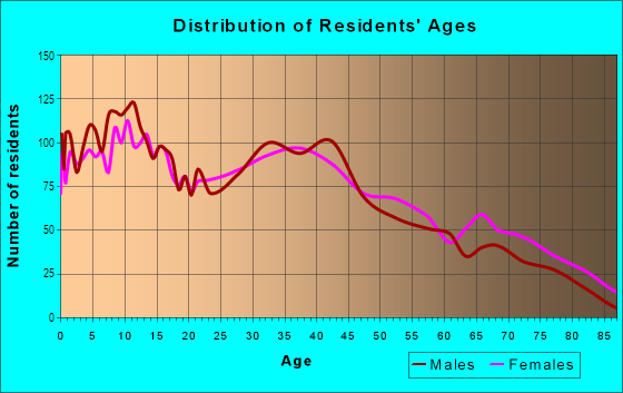
| Males: | 5,599 |
| Females: | 5,755 |
Males:
| This neighborhood: | 38.0 years |
| Whole city: | 39.3 years |
| This neighborhood: | 39.4 years |
| Whole city: | 41.8 years |
Average household size:
| Imperial Highway (Imperial Highway Corridor): | 3.5 people |
| Whittier: | 3.0 people |
Percentage of family households:
| Imperial Highway (Imperial Highway Corridor): | 55.8% |
| Whittier: | 52.7% |
| Here: | 60.9% |
| Whittier: | 51.1% |
Percentage of married-couple families with children (among all households):
| Imperial Highway (Imperial Highway Corridor): | 22.4% |
| Whittier: | 24.8% |
Percentage of single-mother households (among all households):
| Imperial Highway (Imperial Highway Corridor): | 5.0% |
| Whittier: | 3.9% |
Percentage of never married males 15 years old and over:
Percentage of never married females 15 years old and over:
| Imperial Highway (Imperial Highway Corridor): | 14.9% |
| Whittier: | 21.0% |
Percentage of never married females 15 years old and over:
| Imperial Highway (Imperial Highway Corridor): | 15.3% |
| city: | 18.3% |
Percentage of people that speak English not well or not at all:
| Imperial Highway (Imperial Highway Corridor): | 8.6% |
| Whittier: | 5.1% |
Percentage of people born in this state:
Percentage of people born in another U.S. state:
Percentage of native residents but born outside the U.S.:
Percentage of foreign born residents:
| Here: | 61.4% |
| Whittier: | 72.3% |
Percentage of people born in another U.S. state:
| Imperial Highway (Imperial Highway Corridor): | 11.6% |
| Whittier: | 6.6% |
Percentage of native residents but born outside the U.S.:
| Here: | 0.9% |
| city: | 1.1% |
Percentage of foreign born residents:
| Here: | 26.1% |
| Whittier: | 20.1% |

Owner-occupied
Renter-occupied


- Rooms in owner-occupied houses and condos in Imperial Highway <
> - 3621 room
- 02 rooms
- 583 rooms
- 2194 rooms
- 5075 rooms
- 7196 rooms
- 3727 rooms
- 2578 rooms
- 3949+ rooms

- Rooms in renter-occupied apartments in Imperial Highway <
> - 5211 room
- 702 rooms
- 3023 rooms
- 1884 rooms
- 2415 rooms
- 1456 rooms
- 787 rooms
- 808 rooms
- 709+ rooms
Owner-occupied
Renter-occupied

- Bedrooms in owner-occupied houses and condos in Imperial Highway <
> - 362no bedroom
- 1281 bedroom
- 2542 bedrooms
- 1,2873 bedrooms
- 7274 bedrooms
- 2525+ bedrooms

- Bedrooms in renter-occupied apartments in Imperial Highway <
> - 521no bedroom
- 4051 bedroom
- 2962 bedrooms
- 2453 bedrooms
- 1164 bedrooms
- 485+ bedrooms
Average number of cars or other vehicles available in houses/condos:
Average number of cars or other vehicles available in apartments:
| This neighborhood: | 2.6 |
| Whittier: | 2.4 |
Average number of cars or other vehicles available in apartments:
| Here: | |
| city: |
Percentage of units with a mortgage:
| Imperial Highway (Imperial Highway Corridor): | 71.7% |
| Whittier: | 73.9% |
Average estimated value of detached houses in 2022 (78.6% of all units):
| Imperial Highway (Imperial Highway Corridor): | $746,391 |
| California: | $988,808 |

- Year house built in Imperial Highway <
> - 02020 or later
- 422010 to 2019
- 2352000 to 2009
- 3221990 to 1999
- 2621980 to 1989
- 6761970 to 1979
- 5851960 to 1969
- 1,8691950 to 1959
- 681940 to 1949
- 1591939 or earlier

City-data.com crime index for city in 2020 (higher means more crime):
| City: | 192.5 |
| U.S. average: | 219.5 |
Travel time to work (commute)
![Travel time to work (commute)]()
- 56Less than 5 minutes
- 2645 to 9 minutes
- 46510 to 14 minutes
- 73815 to 19 minutes
- 70520 to 24 minutes
- 25725 to 29 minutes
- 78130 to 34 minutes
- 24835 to 39 minutes
- 9740 to 44 minutes
- 50945 to 59 minutes
- 47060 to 89 minutes
- 15690 or more minutes

Means of transportation to work
![Means of transportation to work]()
- 75.7%4,168Drove a car alone
- 7.8%432Carpooled
- 2.7%151Bus
- 0.3%14Subway or elevated rail
- 1.3%73Long-distance train or commuter rail
- 0.2%12Light rail, streetcar or trolley
- 0.9%48Taxi
- 1.1%58Motorcycle
- 2.6%145Bicycle
- 1.4%76Walked
- 1.7%93Other means
- 12.6%696Worked at home

Time leaving home to go to work
![Time leaving home to go to work]()
- 35512:00 a.m. to 4:59 a.m.
- 3535:00 a.m. to 5:29 a.m.
- 2385:30 a.m. to 5:59 a.m.
- 4196:00 a.m. to 6:29 a.m.
- 3216:30 a.m. to 6:59 a.m.
- 5507:00 a.m. to 7:29 a.m.
- 4857:30 a.m. to 7:59 a.m.
- 7978:00 a.m. to 8:29 a.m.
- 2708:30 a.m. to 8:59 a.m.
- 2519:00 a.m. to 9:59 a.m.
- 8010:00 a.m. to 10:59 a.m.
- 6711:00 a.m. to 11:59 a.m.
- 39612:00 p.m. to 3:59 p.m.
- 2004:00 p.m. to 11:59 p.m.

Occupations of males:
- Percentage of males in management occupations (except farmers):
Here: 13.2% city: 10.5%
- Percentage of males in business and financial operations occupations:
Here: 3.3% city: 3.8%
- Percentage of males in computer and mathematical occupations:
Here: 3.6% city: 2.7%
- Percentage of males in architecture and engineering occupations:
Here: 4.8% city: 2.8%
- Percentage of males in community and social services occupations:
Here: 3.4% city: 1.4%
- Percentage of males in education, training, and library occupations:
Here: 5.4% city: 4.7%
- Percentage of males in healthcare practitioners and technical occupations:
Here: 4.1% city: 2.9%
- Percentage of males in service occupations:
Here: 12.6% city: 11.7%
- Percentage of males in sales and office occupations:
Here: 19.8% city: 20.4%
- Percentage of males in farming, fishing, and forestry occupations:
Here: 1.2% city: 0.5%
- Percentage of males in construction, extraction, and maintenance occupations:
Here: 5.8% city: 8.4%
- Percentage of males in production occupations:
Here: 8.8% city: 9.0%
- Percentage of males in transportation occupations:
Here: 3.7% city: 6.8%
- Percentage of males in material moving occupations:
Here: 6.0% city: 5.5%
Occupations of females:
- Percentage of females in management occupations (except farmers):
Here: 11.3% city: 10.5%
- Percentage of females in business and financial operations occupations:
Here: 4.7% city: 7.8%
- Percentage of females in community and social services occupations:
Here: 1.4% city: 2.6%
- Percentage of females in education, training, and library occupations:
Here: 14.4% city: 12.0%
- Percentage of females in arts, design, entertainment, sports, and media occupations:
Here: 1.2% city: 1.9%
- Percentage of females in healthcare practitioners and technical occupations:
Here: 6.4% city: 7.0%
- Percentage of females in service occupations:
Here: 19.3% city: 16.4%
- Percentage of females in sales and office occupations:
Here: 32.7% city: 30.7%
- Percentage of females in production occupations:
Here: 1.5% city: 2.9%
- Percentage of females in transportation occupations:
Here: 1.3% city: 1.3%
- Percentage of females in material moving occupations:
Here: 2.9% city: 2.3%
Education in this neighborhood (subdivision or community):
- Percentage of people 3 years and older in K-12 schools:
Imperial Highway (Imperial Highway Corridor): 21.0% Whittier: 15.5%
- Percentage of people 3 years and older in undergraduate colleges:
Imperial Highway (Imperial Highway Corridor): 6.7% Whittier: 6.9%
- Percentage of people 3 years and older in grad. or professional schools:
Imperial Highway (Imperial Highway Corridor): 3.5% Whittier: 3.3%
- Percentage of students K-12 enrolled in private schools:
Imperial Highway (Imperial Highway Corridor): 61.9% Whittier: 9.5%
Percentage of population below poverty level:
| Imperial Highway (Imperial Highway Corridor): | 7.6% |
| Whittier: | 9.7% |
Median year owner moved in (as recorded in 2022):
| Imperial Highway (Imperial Highway Corridor): | 2003 |
| Whittier: | 2007 |
Percentage of married-couple families with both working:
| Imperial Highway (Imperial Highway Corridor): | 81.4% |
| Whittier: | 63.6% |

- 69.4%Utility gas
- 14.9%Electricity
- 4.6%No fuel used
- 3.8%Solar energy
- 3.6%Other fuel
- 2.2%Wood
- 1.5%Bottled, tank, or LP gas
Highways in this neighborhood:
State Rte 90 (Imperial Hwy)
Length: 3.45 miles
Direction: E-W
Address range: 13801 to 14999
Direction: E-W
Address range: 13801 to 14999
E Imperial Hwy (State Rte 90)
Length: 2.65 miles
Directions: E-W, SE-NW
Address range: 14930 to 15799
Directions: E-W, SE-NW
Address range: 14930 to 15799
Roads and streets:
Leffingwell Rd
Length: 2.78 miles
Directions: E-W, SW-NE
Address range: 13870 to 14999
Directions: E-W, SW-NE
Address range: 13870 to 14999
la Mirada Blvd
Length: 1.53 miles
Direction: N-S
Address range: 11485 to 12735
Direction: N-S
Address range: 11485 to 12735
Valley View Ave
Length: 1.29 miles
Direction: N-S
Address range: 11752 to 12947
Direction: N-S
Address range: 11752 to 12947
Telegraph Rd
Length: 1.14 miles
Directions: E-W, N-S, SE-NW
Address range: 14400 to 14999
Directions: E-W, N-S, SE-NW
Address range: 14400 to 14999
Springview Dr
Length: 0.82 miles
Directions: E-W, N-S, SW-NE
Address range: 11900 to 12399
Directions: E-W, N-S, SW-NE
Address range: 11900 to 12399
Placid Dr
Length: 0.78 miles
Directions: E-W, SW-NE
Address range: 13900 to 15499
Directions: E-W, SW-NE
Address range: 13900 to 15499
Goldendale Dr
Length: 0.70 miles
Directions: E-W, N-S, SE-NW, SW-NE
Address range: 11600 to 12199
Directions: E-W, N-S, SE-NW, SW-NE
Address range: 11600 to 12199
Adoree St
Length: 0.67 miles
Directions: E-W, N-S, SE-NW, SW-NE
Address range: 13800 to 14299
Directions: E-W, N-S, SE-NW, SW-NE
Address range: 13800 to 14299
Meyer Rd
Length: 0.60 miles
Direction: SE-NW
Address range: 13800 to 13999
Direction: SE-NW
Address range: 13800 to 13999
E Tedford Dr
Length: 0.56 miles
Directions: E-W, SW-NE
Address range: 14000 to 14399
Directions: E-W, SW-NE
Address range: 14000 to 14399
Burgess Ave
Length: 0.56 miles
Direction: N-S
Address range: 11800 to 12699
Direction: N-S
Address range: 11800 to 12699
Colima Rd
Length: 0.55 miles
Directions: N-S, SW-NE
Address range: 11658 to 12299
Directions: N-S, SW-NE
Address range: 11658 to 12299
Grayville Dr
Length: 0.53 miles
Directions: E-W, N-S, SE-NW, SW-NE
Address range: 14200 to 14899
Directions: E-W, N-S, SE-NW, SW-NE
Address range: 14200 to 14899
Singleton Dr
Length: 0.52 miles
Directions: E-W, N-S, SE-NW, SW-NE
Address range: 11600 to 12199
Directions: E-W, N-S, SE-NW, SW-NE
Address range: 11600 to 12199
E Busby Dr
Length: 0.52 miles
Directions: E-W, N-S, SE-NW, SW-NE
Address range: 14100 to 14599
Directions: E-W, N-S, SE-NW, SW-NE
Address range: 14100 to 14599
Las Flores Ave
Length: 0.51 miles
Directions: E-W, N-S, SW-NE
Address range: 15100 to 15399
Directions: E-W, N-S, SW-NE
Address range: 15100 to 15399
Corley Dr
Length: 0.51 miles
Directions: E-W, N-S, SE-NW, SW-NE
Address range: 11740 to 12399
Directions: E-W, N-S, SE-NW, SW-NE
Address range: 11740 to 12399
Ramhurst Dr
Length: 0.50 miles
Direction: E-W
Address range: 13900 to 14899
Direction: E-W
Address range: 13900 to 14899
Oxford Dr
Length: 0.50 miles
Directions: N-S, SW-NE
Address range: 12200 to 12927
Directions: N-S, SW-NE
Address range: 12200 to 12927
Keese Dr
Length: 0.49 miles
Directions: E-W, N-S, SE-NW
Address range: 14200 to 14699
Directions: E-W, N-S, SE-NW
Address range: 14200 to 14699
Chere Dr
Length: 0.48 miles
Directions: E-W, N-S, SW-NE
Address range: 14100 to 14599
Directions: E-W, N-S, SW-NE
Address range: 14100 to 14599
Richvale Dr
Length: 0.40 miles
Directions: E-W, SE-NW
Address range: 14600 to 14999
Directions: E-W, SE-NW
Address range: 14600 to 14999
Saranac Dr
Length: 0.38 miles
Directions: E-W, N-S, SW-NE
Address range: 13800 to 14199
Directions: E-W, N-S, SW-NE
Address range: 13800 to 14199
Armsdale Ave
Length: 0.37 miles
Direction: N-S
Address range: 11700 to 12199
Direction: N-S
Address range: 11700 to 12199
Woodridge Ave
Length: 0.37 miles
Directions: E-W, N-S, SE-NW, SW-NE
Address range: 12300 to 12999
Directions: E-W, N-S, SE-NW, SW-NE
Address range: 12300 to 12999
Steprock Dr
Length: 0.36 miles
Directions: E-W, SE-NW
Address range: 14800 to 15199
Directions: E-W, SE-NW
Address range: 14800 to 15199
Loma Dr
Length: 0.35 miles
Direction: N-S
Address range: 11848 to 12399
Direction: N-S
Address range: 11848 to 12399
Edderton Ave
Length: 0.35 miles
Directions: E-W, N-S, SE-NW, SW-NE
Address range: 11900 to 13038
Directions: E-W, N-S, SE-NW, SW-NE
Address range: 11900 to 13038
Hollyview Dr
Length: 0.35 miles
Directions: E-W, N-S, SW-NE
Address range: 11600 to 11899
Directions: E-W, N-S, SW-NE
Address range: 11600 to 11899
Fairacres Dr
Length: 0.35 miles
Directions: E-W, N-S, SW-NE
Address range: 14600 to 15106
Directions: E-W, N-S, SW-NE
Address range: 14600 to 15106
Surrey Ln
Length: 0.32 miles
Directions: E-W, SW-NE
Address range: 15400 to 15699
Directions: E-W, SW-NE
Address range: 15400 to 15699
Ocaso Ave
Length: 0.30 miles
Directions: N-S, SE-NW
Address range: 12300 to 12729
Directions: N-S, SE-NW
Address range: 12300 to 12729
Tanfield Dr
Length: 0.30 miles
Directions: N-S, SW-NE
Address range: 12000 to 12699
Directions: N-S, SW-NE
Address range: 12000 to 12699
Ramsey Dr
Length: 0.29 miles
Directions: E-W, N-S, SE-NW, SW-NE
Address range: 12300 to 12999
Directions: E-W, N-S, SE-NW, SW-NE
Address range: 12300 to 12999
Los Coyotes Ave
Length: 0.27 miles
Directions: N-S, SE-NW, SW-NE
Address range: 12033 to 12299
Directions: N-S, SE-NW, SW-NE
Address range: 12033 to 12299
Gagely Dr
Length: 0.26 miles
Directions: E-W, SE-NW
Address range: 14200 to 14499
Directions: E-W, SE-NW
Address range: 14200 to 14499
Gayview Dr
Length: 0.24 miles
Directions: E-W, SW-NE
Address range: 11600 to 11799
Directions: E-W, SW-NE
Address range: 11600 to 11799
Bonavista Ln
Length: 0.23 miles
Direction: N-S
Address range: 12000 to 12299
Direction: N-S
Address range: 12000 to 12299
Tedford Dr
Length: 0.23 miles
Directions: E-W, SW-NE
Address range: 14400 to 14599
Directions: E-W, SW-NE
Address range: 14400 to 14599
Sunnymead Dr
Length: 0.22 miles
Directions: SE-NW, SW-NE
Address range: 14600 to 14799
Directions: SE-NW, SW-NE
Address range: 14600 to 14799
Weeks Dr
Length: 0.22 miles
Directions: E-W, N-S, SE-NW
Address range: 14700 to 15007
Directions: E-W, N-S, SE-NW
Address range: 14700 to 15007
la Pomelo Rd
Length: 0.21 miles
Directions: E-W, N-S
Address range: 12200 to 12499
Directions: E-W, N-S
Address range: 12200 to 12499
Kessock Ave
Length: 0.21 miles
Directions: E-W, N-S, SW-NE
Address range: 11900 to 12099
Directions: E-W, N-S, SW-NE
Address range: 11900 to 12099
E Keese Dr
Length: 0.20 miles
Directions: E-W, SE-NW
Address range: 14700 to 14899
Directions: E-W, SE-NW
Address range: 14700 to 14899
Starpath Dr
Length: 0.20 miles
Directions: E-W, N-S, SE-NW, SW-NE
Address range: 14600 to 14799
Directions: E-W, N-S, SE-NW, SW-NE
Address range: 14600 to 14799
Edwards Rd
Length: 0.20 miles
Directions: E-W, N-S, SW-NE
Address range: 12600 to 12999
Directions: E-W, N-S, SW-NE
Address range: 12600 to 12999
Hutchins Dr
Length: 0.19 miles
Directions: E-W, SW-NE
Address range: 14900 to 14999
Directions: E-W, SW-NE
Address range: 14900 to 14999
Lake Forest Way (Lake Forest Ave)
Length: 0.18 miles
Direction: N-S
Address range: 12600 to 12999
Direction: N-S
Address range: 12600 to 12999
Santa Gertrudes Ave
Length: 0.18 miles
Directions: N-S, SE-NW, SW-NE
Address range: 12324 to 12687
Directions: N-S, SE-NW, SW-NE
Address range: 12324 to 12687
Oakthorn Ln
Length: 0.18 miles
Directions: E-W, N-S, SE-NW
Address range: 12600 to 12799
Directions: E-W, N-S, SE-NW
Address range: 12600 to 12799
S Parise Dr
Length: 0.18 miles
Directions: N-S, SE-NW
Address range: 12000 to 12199
Directions: N-S, SE-NW
Address range: 12000 to 12199
Lake Park Way
Length: 0.17 miles
Directions: E-W, N-S, SW-NE
Address range: 12600 to 12699
Directions: E-W, N-S, SW-NE
Address range: 12600 to 12699
Eagan Dr
Length: 0.17 miles
Direction: N-S
Address range: 11800 to 11999
Direction: N-S
Address range: 11800 to 11999
Lakeview Dr
Length: 0.17 miles
Directions: E-W, N-S, SW-NE
Address range: 14000 to 14199
Directions: E-W, N-S, SW-NE
Address range: 14000 to 14199
Lake Glen Dr
Length: 0.17 miles
Direction: E-W
Address range: 14000 to 14099
Direction: E-W
Address range: 14000 to 14099
Lake Crest Dr
Length: 0.17 miles
Direction: E-W
Address range: 14000 to 14099
Direction: E-W
Address range: 14000 to 14099
Lucinda Dr
Length: 0.17 miles
Directions: E-W, SW-NE
Address range: 14700 to 14799
Directions: E-W, SW-NE
Address range: 14700 to 14799
Duffield Ave
Length: 0.16 miles
Direction: N-S
Address range: 12400 to 12961
Direction: N-S
Address range: 12400 to 12961
Rimrock Dr
Length: 0.16 miles
Directions: N-S, SE-NW
Address range: 11700 to 11899
Directions: N-S, SE-NW
Address range: 11700 to 11899
Moline Dr
Length: 0.16 miles
Directions: N-S, SW-NE
Address range: 12200 to 12399
Directions: N-S, SW-NE
Address range: 12200 to 12399
Bristol Dr
Length: 0.16 miles
Directions: E-W, N-S, SE-NW
Address range: 12200 to 12399
Directions: E-W, N-S, SE-NW
Address range: 12200 to 12399
Loretta Dr
Length: 0.15 miles
Direction: E-W
Address range: 14900 to 15299
Direction: E-W
Address range: 14900 to 15299
la Sabana Dr
Length: 0.15 miles
Directions: E-W, SW-NE
Address range: 15100 to 15199
Directions: E-W, SW-NE
Address range: 15100 to 15199
Lakeside Dr
Length: 0.14 miles
Direction: E-W
Address range: 14000 to 14099
Direction: E-W
Address range: 14000 to 14099
Plantana Dr
Length: 0.13 miles
Directions: N-S, SW-NE
Address range: 14500 to 14599
Directions: N-S, SW-NE
Address range: 14500 to 14599
Chadsey Dr
Length: 0.13 miles
Direction: N-S
Address range: 12700 to 12899
Direction: N-S
Address range: 12700 to 12899
Crestaloma Ln
Length: 0.12 miles
Directions: E-W, SW-NE
Address range: 15300 to 15399
Directions: E-W, SW-NE
Address range: 15300 to 15399
Nashville Ave
Length: 0.12 miles
Directions: SE-NW, SW-NE
Address range: 11900 to 12199
Directions: SE-NW, SW-NE
Address range: 11900 to 12199
Wicker Dr
Length: 0.11 miles
Directions: N-S, SW-NE
Address range: 12300 to 12399
Directions: N-S, SW-NE
Address range: 12300 to 12399
Erin Ln
Length: 0.11 miles
Direction: N-S
Address range: 12100 to 12199
Direction: N-S
Address range: 12100 to 12199
Sparwood Ln
Length: 0.11 miles
Directions: E-W, N-S, SE-NW, SW-NE
Address range: 12600 to 12799
Directions: E-W, N-S, SE-NW, SW-NE
Address range: 12600 to 12799
Marquardt Ave
Length: 0.11 miles
Direction: N-S
Address range: 12600 to 12799
Direction: N-S
Address range: 12600 to 12799
Granada Ave
Length: 0.11 miles
Direction: E-W
Address range: 15000 to 15049
Direction: E-W
Address range: 15000 to 15049
S Sunnybrook Ln
Length: 0.11 miles
Direction: N-S
Address range: 12200 to 12299
Direction: N-S
Address range: 12200 to 12299
Chalco St
Length: 0.11 miles
Directions: E-W, N-S
Address range: 15000 to 15099
Directions: E-W, N-S
Address range: 15000 to 15099
el Moro Ave
Length: 0.10 miles
Direction: N-S
Address range: 12800 to 12999
Direction: N-S
Address range: 12800 to 12999
del Vista Dr
Length: 0.10 miles
Directions: E-W, SE-NW
Address range: 12100 to 12199
Directions: E-W, SE-NW
Address range: 12100 to 12199
Longleaf Dr
Length: 0.09 miles
Directions: E-W, N-S, SE-NW
Address range: 12600 to 12699
Directions: E-W, N-S, SE-NW
Address range: 12600 to 12699
Bluefield Ave
Length: 0.09 miles
Directions: N-S, SW-NE
Address range: 12014 to 12199
Directions: N-S, SW-NE
Address range: 12014 to 12199
Henning Dr
Length: 0.09 miles
Directions: E-W, N-S, SE-NW, SW-NE
Address range: 14700 to 14799
Directions: E-W, N-S, SE-NW, SW-NE
Address range: 14700 to 14799
Gerber Ave
Length: 0.09 miles
Direction: N-S
Address range: 12100 to 12199
Direction: N-S
Address range: 12100 to 12199
Courser Ave
Length: 0.09 miles
Directions: N-S, SW-NE
Address range: 12100 to 12199
Directions: N-S, SW-NE
Address range: 12100 to 12199
Quail Ln
Length: 0.08 miles
Direction: E-W
Address range: 15200 to 15299
Direction: E-W
Address range: 15200 to 15299
Arroyo Dr
Length: 0.08 miles
Directions: N-S, SE-NW
Address range: 11600 to 11699
Directions: N-S, SE-NW
Address range: 11600 to 11699
Hillwood Dr
Length: 0.08 miles
Direction: SW-NE
Address range: 12200 to 12299
Direction: SW-NE
Address range: 12200 to 12299
Thermal Dr
Length: 0.08 miles
Direction: N-S
Address range: 11700 to 11799
Direction: N-S
Address range: 11700 to 11799
Coteau Dr
Length: 0.07 miles
Direction: N-S
Address range: 13900 to 14199
Direction: N-S
Address range: 13900 to 14199
Obert Ave
Length: 0.07 miles
Direction: N-S
Address range: 11500 to 11599
Direction: N-S
Address range: 11500 to 11599
Cordova Rd
Length: 0.07 miles
Directions: E-W, N-S, SW-NE
Address range: 15150 to 15199
Directions: E-W, N-S, SW-NE
Address range: 15150 to 15199
Kelford St
Length: 0.07 miles
Direction: E-W
Address range: 14100 to 14199
Direction: E-W
Address range: 14100 to 14199
Gottes Ln
Length: 0.06 miles
Direction: N-S
Address range: 12300 to 12499
Direction: N-S
Address range: 12300 to 12499
Ronald Dr
Length: 0.06 miles
Direction: N-S
Address range: 11700 to 11799
Direction: N-S
Address range: 11700 to 11799
Sparrow Dr
Length: 0.06 miles
Directions: E-W, SE-NW
Address range: 14900 to 14999
Directions: E-W, SE-NW
Address range: 14900 to 14999
Woodbay Dr
Length: 0.05 miles
Direction: E-W
Address range: 14900 to 14999
Direction: E-W
Address range: 14900 to 14999
Double Eagle Dr
Length: 0.05 miles
Direction: N-S
Address range: 11500 to 11599
Direction: N-S
Address range: 11500 to 11599
Parise Dr
Length: 0.04 miles
Direction: SE-NW
Address range: 11900 to 11999
Direction: SE-NW
Address range: 11900 to 11999
Derby Ln
Length: 0.04 miles
Direction: E-W
Address range: 15500 to 15599
Direction: E-W
Address range: 15500 to 15599
Steen Pl
Length: 0.03 miles
Direction: SW-NE
Address range: 11800 to 11899
Direction: SW-NE
Address range: 11800 to 11899
Spangler Pl
Length: 0.03 miles
Direction: SE-NW
Address range: 14800 to 14899
Direction: SE-NW
Address range: 14800 to 14899
Trailer Prk Entrance
Length: 0.03 miles
Direction: E-W
Direction: E-W
Biola Ave
Length: 0.03 miles
Direction: N-S
Address range: 12600 to 12613
Direction: N-S
Address range: 12600 to 12613
Saranac Pl
Length: 0.03 miles
Directions: N-S, SE-NW
Address range: 14143 to 14173
Directions: N-S, SE-NW
Address range: 14143 to 14173
Heller Pl
Length: 0.03 miles
Direction: SE-NW
Address range: 14900 to 14999
Direction: SE-NW
Address range: 14900 to 14999
Gabbett Dr
Length: 0.03 miles
Direction: N-S
Address range: 12600 to 12628
Direction: N-S
Address range: 12600 to 12628
Other features:
la Mirada Crk
Length: 0.60 miles
Directions: E-W, SW-NE
Directions: E-W, SW-NE
Sorensen Drn
Length: 0.01 miles
Direction: N-S
Direction: N-S