Bridge Statistics for Acton, California (CA)
Condition, Traffic, Stress, Structural Evaluation, Project Costs
- National Bridge Inventory (NBI) Statistics
- 28Number of bridges
- 302ft / 92.5mTotal length
- 1,336,991Total average daily traffic
- 26,331Total average daily truck traffic
- National Bridge Inventory (NBI) Registered Bridges for Acton
- No street view available for this location
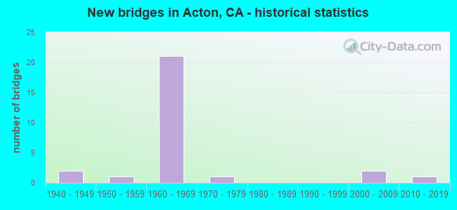
- New bridges - historical statistics
- 21940-1949
- 11950-1959
- 211960-1969
- 11970-1979
- 22000-2009
- 12010-2019

- Reconstructed bridges - Historical Statistics
- 11950-1959
- 01960-1969
- 01970-1979
- 01980-1989
- 71990-1999
- 22000-2009


- Bridge Condition - Deck
- 70.6%Good
- 17.6%Satisfactory
- 11.8%Fair

- Bridge Condition - Superstructure
- 88.2%Good
- 11.8%Satisfactory

- Bridge Condition - Substructure
- 88.2%Good
- 11.8%Fair

- Bridge Condition - Channel
- 18.2%Excellent
- 9.1%Very good
- 45.5%Good
- 27.3%Satisfactory

- Bridge Condition - Culverts
- 16.7%Very good
- 66.7%Good
- 16.7%Satisfactory
Find on map >> Show street view
Structure Number: 53 0147L, Location: 07-LA-014-R47.34 (Lat: 34.497094, Lng: -118.219075), Route carried "on" structure: State highway 14, Year Built: 1965, Year Reconstructed: 2002, Status: Open, Structure Length: 5.16m (16.93ft), Average Daily Traffic: 49,000 (year 2019), Average Future Daily Traffic: 91,127 (year 2041), Design Load: HS 20, Features Intersected: RED ROVER MINE ROAD
Minimum Vertical Clearance: 30+ m (98+ ft), Kilometerpoint: 47.340, Lanes on structure: 3, Lanes under structure: 2, Base Highway Network: Yes (, Subroute: 1), Owner: State Highway Agency, Approaching Roadway Width: 17.7m (58.1ft), Skew: 3 degrees, Material/Design: Concrete continuous, Design/Construction: Tee Beam, Number Of Spans In Main Unit: 3, Length of Maximum Span: 22.9m (75.1ft), Curb-To-Curb Width: 17.7m (58.1ft), Out-to-Out Width: 18.5m (60.7ft)
Condition: Deck: Good, Superstructure: Good, Substructure: Good, Operating Rating: 31.4 metric tons, Method Used To Determine Operating Rating: Load and Resistance Factor Rating (LRFR) rating reported by rating factor(RF) method using HL-93 loadings, Inventory Rating: 24.3 metric tons, Method Used To Determine Inventory Rating: Load and Resistance Factor Rating (LRFR) rating reported by rating factor(RF) method using HL-93 loadings, Structural Evaluation: Equal to present minimum criteria, Deck Geometry: Superior to present desirable criteria, Underclear: High priority of corrective action, Approach Roadway Alignment: Equal to present desirable criteria, Designated Inspection Frequency: Every 24 months, Inspection Date: Febuary 2021, Deck Structure Type: Concrete Cast-file-Place, Wearing Surface/Protective System: Wearing Surface: Integral Concrete
Find on map >> Show street view
Structure Number: 53 0147R, Location: 07-LA-014-R47.34 (Lat: 34.496808, Lng: -118.219094), Route carried "on" structure: State highway 14, Year Built: 1965, Year Reconstructed: 2002, Status: Open, Structure Length: 5.16m (16.93ft), Average Daily Traffic: 49,000 (year 2019), Average Future Daily Traffic: 91,127 (year 2041), Design Load: HS 20, Features Intersected: RED ROVER MINE ROAD
Minimum Vertical Clearance: 30+ m (98+ ft), Kilometerpoint: 47.340, Lanes on structure: 3, Lanes under structure: 2, Base Highway Network: Yes (, Subroute: 1), Owner: State Highway Agency, Approaching Roadway Width: 17.7m (58.1ft), Skew: 3 degrees, Material/Design: Concrete continuous, Design/Construction: Tee Beam, Number Of Spans In Main Unit: 3, Length of Maximum Span: 22.9m (75.1ft), Curb-To-Curb Width: 17.7m (58.1ft), Out-to-Out Width: 18.5m (60.7ft)
Condition: Deck: Good, Superstructure: Good, Substructure: Good, Operating Rating: 31.4 metric tons, Method Used To Determine Operating Rating: Load and Resistance Factor Rating (LRFR) rating reported by rating factor(RF) method using HL-93 loadings, Inventory Rating: 24.3 metric tons, Method Used To Determine Inventory Rating: Load and Resistance Factor Rating (LRFR) rating reported by rating factor(RF) method using HL-93 loadings, Structural Evaluation: Equal to present minimum criteria, Deck Geometry: Superior to present desirable criteria, Underclear: Meets minimum limits, Approach Roadway Alignment: Equal to present desirable criteria, Designated Inspection Frequency: Every 24 months, Inspection Date: Febuary 2021, Deck Structure Type: Concrete Cast-file-Place
Find on map >> Show street view
Structure Number: 53 0868L, Location: 07-LA-014-R48.61 (Lat: 34.491808, Lng: -118.198497), Route carried "on" structure: State highway 14, Year Built: 1965, Year Reconstructed: 2000, Status: Open, Structure Length: 4.48m (14.70ft), Average Daily Traffic: 49,000 (year 2019), Average Future Daily Traffic: 91,127 (year 2041), Design Load: HS 20, Features Intersected: CROWN VALLLEY RD
Minimum Vertical Clearance: 30+ m (98+ ft), Kilometerpoint: 48.610, Lanes on structure: 3, Lanes under structure: 3, Base Highway Network: Yes (, Subroute: 1), Owner: State Highway Agency, Approaching Roadway Width: 17.7m (58.1ft), Skew: 1 degrees, Material/Design: Concrete continuous, Design/Construction: Tee Beam, Number Of Spans In Main Unit: 3, Length of Maximum Span: 20.1m (65.9ft), Curb-To-Curb Width: 17.7m (58.1ft), Out-to-Out Width: 18.5m (60.7ft)
Condition: Deck: Good, Superstructure: Good, Substructure: Good, Operating Rating: 31.8 metric tons, Method Used To Determine Operating Rating: Load and Resistance Factor Rating (LRFR) rating reported by rating factor(RF) method using HL-93 loadings, Inventory Rating: 24.6 metric tons, Method Used To Determine Inventory Rating: Load and Resistance Factor Rating (LRFR) rating reported by rating factor(RF) method using HL-93 loadings, Structural Evaluation: Equal to present minimum criteria, Deck Geometry: Superior to present desirable criteria, Underclear: Meets minimum limits, Approach Roadway Alignment: Equal to present desirable criteria, Designated Inspection Frequency: Every 24 months, Inspection Date: Febuary 2021, Deck Structure Type: Concrete Cast-file-Place
Find on map >> Show street view
Structure Number: 53 0868R, Location: 07-LA-014-R48.61 (Lat: 34.491361, Lng: -118.198497), Route carried "on" structure: State highway 14, Year Built: 1965, Year Reconstructed: 2002, Status: Open, Structure Length: 4.48m (14.70ft), Average Daily Traffic: 49,000 (year 2019), Average Future Daily Traffic: 91,127 (year 2041), Design Load: HS 20, Features Intersected: CROWN VALLLEY RD
Minimum Vertical Clearance: 30+ m (98+ ft), Kilometerpoint: 48.610, Lanes on structure: 3, Lanes under structure: 3, Base Highway Network: Yes (, Subroute: 1), Owner: State Highway Agency, Approaching Roadway Width: 17.7m (58.1ft), Skew: 1 degrees, Material/Design: Concrete continuous, Design/Construction: Tee Beam, Number Of Spans In Main Unit: 3, Length of Maximum Span: 20.1m (65.9ft), Curb-To-Curb Width: 17.7m (58.1ft), Out-to-Out Width: 18.5m (60.7ft)
Condition: Deck: Good, Superstructure: Good, Substructure: Good, Operating Rating: 31.8 metric tons, Method Used To Determine Operating Rating: Load and Resistance Factor Rating (LRFR) rating reported by rating factor(RF) method using HL-93 loadings, Inventory Rating: 24.6 metric tons, Method Used To Determine Inventory Rating: Load and Resistance Factor Rating (LRFR) rating reported by rating factor(RF) method using HL-93 loadings, Structural Evaluation: Equal to present minimum criteria, Deck Geometry: Superior to present desirable criteria, Underclear: Somewhat better than minimum adequacy, Approach Roadway Alignment: Equal to present desirable criteria, Designated Inspection Frequency: Every 24 months, Inspection Date: Febuary 2021, Deck Structure Type: Concrete Cast-file-Place
Find on map >> Show street view
Structure Number: 53 0871L, Location: 07-LA-014-R50.75 (Lat: 34.488967, Lng: -118.162864), Route carried "on" structure: State highway 14, Year Built: 1965, Year Reconstructed: 2002, Status: Open, Structure Length: 4.48m (14.70ft), Average Daily Traffic: 48,500 (year 2019), Truck Traffic: 5%, Average Future Daily Traffic: 94,319 (year 2041), Design Load: HS 20, Features Intersected: SANTIAGO RD
Minimum Vertical Clearance: 30+ m (98+ ft), Kilometerpoint: 50.750, Lanes on structure: 3, Lanes under structure: 2, Base Highway Network: Yes (, Subroute: 1), Owner: State Highway Agency, Approaching Roadway Width: 17.7m (58.1ft), Material/Design: Concrete continuous, Design/Construction: Tee Beam, Number Of Spans In Main Unit: 3, Length of Maximum Span: 20.1m (65.9ft), Curb-To-Curb Width: 17.7m (58.1ft), Out-to-Out Width: 18.5m (60.7ft)
Condition: Deck: Good, Superstructure: Good, Substructure: Good, Operating Rating: 23.7 metric tons, Method Used To Determine Operating Rating: Load and Resistance Factor Rating (LRFR) rating reported by rating factor(RF) method using HL-93 loadings, Inventory Rating: 18.5 metric tons, Method Used To Determine Inventory Rating: Load and Resistance Factor Rating (LRFR) rating reported by rating factor(RF) method using HL-93 loadings, Structural Evaluation: Meets minimum limits, Deck Geometry: Superior to present desirable criteria, Underclear: High priority of corrective action, Approach Roadway Alignment: Equal to present desirable criteria, Designated Inspection Frequency: Every 24 months, Inspection Date: Febuary 2021, Deck Structure Type: Concrete Cast-file-Place
Find on map >> Show street view
Structure Number: 53 0871R, Location: 07-LA-014-R50.75 (Lat: 34.488614, Lng: -118.163189), Route carried "on" structure: State highway 14, Year Built: 1965, Year Reconstructed: 2002, Status: Open, Structure Length: 4.48m (14.70ft), Average Daily Traffic: 48,500 (year 2019), Truck Traffic: 5%, Average Future Daily Traffic: 94,319 (year 2041), Design Load: HS 20+Mod, Features Intersected: SANTIAGO RD
Minimum Vertical Clearance: 30+ m (98+ ft), Kilometerpoint: 50.750, Lanes on structure: 3, Lanes under structure: 2, Base Highway Network: Yes (, Subroute: 1), Owner: State Highway Agency, Approaching Roadway Width: 17.7m (58.1ft), Material/Design: Concrete continuous, Design/Construction: Tee Beam, Number Of Spans In Main Unit: 3, Length of Maximum Span: 20.1m (65.9ft), Curb-To-Curb Width: 17.7m (58.1ft), Out-to-Out Width: 18.5m (60.7ft)
Condition: Deck: Good, Superstructure: Good, Substructure: Good, Operating Rating: 23.7 metric tons, Method Used To Determine Operating Rating: Load and Resistance Factor Rating (LRFR) rating reported by rating factor(RF) method using HL-93 loadings, Inventory Rating: 18.5 metric tons, Method Used To Determine Inventory Rating: Load and Resistance Factor Rating (LRFR) rating reported by rating factor(RF) method using HL-93 loadings, Structural Evaluation: Meets minimum limits, Deck Geometry: Superior to present desirable criteria, Underclear: High priority of corrective action, Approach Roadway Alignment: Equal to present desirable criteria, Designated Inspection Frequency: Every 24 months, Inspection Date: Febuary 2021, Deck Structure Type: Concrete Cast-file-Place
Find on map >> Show street view
Structure Number: 53 0979, Location: 07-LA-014-R52.17 (Lat: 34.487603, Lng: -118.140350), Route carried "on" structure: County highway , Year Built: 1965, Status: Open, Structure Length: 8.79m (28.84ft), Average Daily Traffic: 4,900 (year 2017), Truck Traffic: 2%, Average Future Daily Traffic: 7,211 (year 2041), Design Load: HS 20, Features Intersected: ROUTE 14, Facility Carried by Structure: SIERRA HWY OC
Minimum Vertical Clearance: 30+ m (98+ ft), Kilometerpoint: 0.000, Lanes on structure: 2, Lanes under structure: 6, Base Highway Network: Yes, Owner: State Highway Agency, Approaching Roadway Width: 9.2m (30.2ft), Skew: 3 degrees, Material/Design: Concrete continuous, Design/Construction: Box Beam or Girders - Multiple, Number Of Spans In Main Unit: 4, Length of Maximum Span: 28.0m (91.9ft), Curb or Sidewalk Widths: Left: 0.6m (2.0ft), Right: 0.0m, Curb-To-Curb Width: 9.2m (30.2ft), Out-to-Out Width: 10.7m (35.1ft)
Condition: Deck: Fair, Superstructure: Good, Substructure: Good, Operating Rating: 38.6 metric tons, Method Used To Determine Operating Rating: Load and Resistance Factor Rating (LRFR) rating reported by rating factor(RF) method using HL-93 loadings, Inventory Rating: 29.8 metric tons, Method Used To Determine Inventory Rating: Load and Resistance Factor Rating (LRFR) rating reported by rating factor(RF) method using HL-93 loadings, Structural Evaluation: Better than present minimum criteria, Deck Geometry: Meets minimum limits, Underclear: Better than present minimum criteria, Approach Roadway Alignment: Equal to present desirable criteria, Designated Inspection Frequency: Every 24 months, Inspection Date: March 2021, Deck Structure Type: Concrete Cast-file-Place
Find on map >> Show street view
Structure Number: 53 1005, Location: 07-LA-014-R54.55 (Lat: 34.510956, Lng: -118.110911), Route carried "on" structure: State highway 14, Year Built: 1965, Year Reconstructed: 2006, Status: Open, Structure Length: 6.43m (21.10ft), Average Daily Traffic: 105,000 (year 2017), Truck Traffic: 4%, Average Future Daily Traffic: 187,386 (year 2041), Design Load: HS 20, Features Intersected: VINCENT RAMP UC
Minimum Vertical Clearance: 30+ m (98+ ft), Kilometerpoint: 54.550, Lanes on structure: 6, Lanes under structure: 4, Base Highway Network: Yes (, Subroute: 1), Owner: State Highway Agency, Approaching Roadway Width: 32.4m (106.3ft), Skew: 33 degrees, Material/Design: Concrete continuous, Design/Construction: Box Beam or Girders - Multiple, Number Of Spans In Main Unit: 3, Length of Maximum Span: 28.0m (91.9ft), Curb-To-Curb Width: 32.4m (106.3ft), Out-to-Out Width: 33.9m (111.2ft)
Condition: Deck: Fair, Superstructure: Good, Substructure: Good, Operating Rating: 77.1 metric tons, Method Used To Determine Operating Rating: Load Factor (LF), Inventory Rating: 46.3 metric tons, Method Used To Determine Inventory Rating: Load Factor (LF), Structural Evaluation: Better than present minimum criteria, Deck Geometry: Superior to present desirable criteria, Underclear: Equal to present minimum criteria, Approach Roadway Alignment: Equal to present desirable criteria, Designated Inspection Frequency: Every 24 months, Inspection Date: March 2021, Deck Structure Type: Concrete Cast-file-Place
Find on map >> Show street view
Structure Number: 53 1545L, Location: 07-LA-014-45.73 (Lat: 34.504714, Lng: -118.245514), Route carried "on" structure: State highway 14, Year Built: 1963, Year Reconstructed: 2002, Status: Open, Structure Length: 3.05m (10.01ft), Average Daily Traffic: 48,500 (year 2019), Average Future Daily Traffic: 94,163 (year 2041), Features Intersected: PURITAN MINE ROAD
Minimum Vertical Clearance: 30+ m (98+ ft), Kilometerpoint: 45.730, Lanes on structure: 3, Lanes under structure: 2, Base Highway Network: Yes (, Subroute: 1), Owner: State Highway Agency, Approaching Roadway Width: 17.5m (57.4ft), Material/Design: Concrete, Design/Construction: Tee Beam, Number Of Spans In Main Unit: 3, Length of Maximum Span: 12.2m (40.0ft), Curb-To-Curb Width: 17.5m (57.4ft), Out-to-Out Width: 18.5m (60.7ft)
Condition: Deck: Good, Superstructure: Good, Substructure: Good, Operating Rating: 52.8 metric tons, Method Used To Determine Operating Rating: Load Factor (LF), Inventory Rating: 34.0 metric tons, Method Used To Determine Inventory Rating: Load Factor (LF), Structural Evaluation: Better than present minimum criteria, Deck Geometry: Superior to present desirable criteria, Underclear: Meets minimum limits, Approach Roadway Alignment: Equal to present desirable criteria, Designated Inspection Frequency: Every 24 months, Inspection Date: Febuary 2021, Deck Structure Type: Concrete Cast-file-Place
Find on map >> Show street view
Structure Number: 53 1545R, Location: 07-LA-014-45.73 (Lat: 34.504475, Lng: -118.245594), Route carried "on" structure: State highway 14, Year Built: 1963, Year Reconstructed: 2002, Status: Open, Structure Length: 3.05m (10.01ft), Average Daily Traffic: 48,500 (year 2019), Average Future Daily Traffic: 94,163 (year 2041), Design Load: HS 20, Features Intersected: PURITAN MINE ROAD
Minimum Vertical Clearance: 30+ m (98+ ft), Kilometerpoint: 45.730, Lanes on structure: 3, Lanes under structure: 2, Base Highway Network: Yes (, Subroute: 1), Owner: State Highway Agency, Approaching Roadway Width: 17.6m (57.7ft), Material/Design: Concrete continuous, Design/Construction: Tee Beam, Number Of Spans In Main Unit: 3, Length of Maximum Span: 12.2m (40.0ft), Curb-To-Curb Width: 17.6m (57.7ft), Out-to-Out Width: 18.5m (60.7ft)
Condition: Deck: Good, Superstructure: Good, Substructure: Good, Operating Rating: 52.8 metric tons, Method Used To Determine Operating Rating: Load Factor (LF), Inventory Rating: 34.0 metric tons, Method Used To Determine Inventory Rating: Load Factor (LF), Structural Evaluation: Better than present minimum criteria, Deck Geometry: Superior to present desirable criteria, Underclear: Meets minimum limits, Approach Roadway Alignment: Equal to present desirable criteria, Designated Inspection Frequency: Every 24 months, Inspection Date: Febuary 2021, Deck Structure Type: Concrete Cast-file-Place
Find on map >> Show street view
Structure Number: 53 1546, Location: 07-LA-014-46.76 (Lat: 34.501047, Lng: -118.228342), Route carried "on" structure: County highway , Year Built: 1968, Status: Open, Structure Length: 8.81m (28.90ft), Average Daily Traffic: 3,500 (year 2019), Truck Traffic: 1%, Average Future Daily Traffic: 5,255 (year 2041), Design Load: HS 20, Features Intersected: ROUTE 14, Facility Carried by Structure: WARD ROAD
Minimum Vertical Clearance: 30+ m (98+ ft), Kilometerpoint: 0.000, Lanes on structure: 4, Lanes under structure: 6, Owner: State Highway Agency, Approaching Roadway Width: 17.1m (56.1ft), Skew: 3 degrees, Material/Design: Concrete continuous, Design/Construction: Box Beam or Girders - Multiple, Number Of Spans In Main Unit: 4, Length of Maximum Span: 31.5m (103.3ft), Curb or Sidewalk Widths: Left: 0.0m, Right: 1.9m (6.2ft), Curb-To-Curb Width: 17.1m (56.1ft), Out-to-Out Width: 19.9m (65.3ft)
Condition: Deck: Good, Superstructure: Good, Substructure: Fair, Operating Rating: 56.1 metric tons, Method Used To Determine Operating Rating: Load and Resistance Factor Rating (LRFR) rating reported by rating factor(RF) method using HL-93 loadings, Inventory Rating: 43.1 metric tons, Method Used To Determine Inventory Rating: Load and Resistance Factor Rating (LRFR) rating reported by rating factor(RF) method using HL-93 loadings, Structural Evaluation: Somewhat better than minimum adequacy, Deck Geometry: Somewhat better than minimum adequacy, Underclear: Equal to present minimum criteria, Approach Roadway Alignment: Equal to present desirable criteria, Designated Inspection Frequency: Every 24 months, Inspection Date: Febuary 2021, Deck Structure Type: Concrete Cast-file-Place
Find on map >> Show street view
Structure Number: 53 1793, Location: 07-LA-014-46.60 (Lat: 34.501344, Lng: -118.230828), Route carried "on" structure: State highway 14, Year Built: 1963, Status: Open, Structure Length: 0.76m (2.49ft), Average Daily Traffic: 97,000 (year 2019), Average Future Daily Traffic: 188,327 (year 2041), Design Load: HS 20, Features Intersected: WARD WASH
Minimum Vertical Clearance: 30+ m (98+ ft), Kilometerpoint: 46.600, Lanes on structure: 6, Base Highway Network: Yes (, Subroute: 1), Owner: State Highway Agency, Approaching Roadway Width: 39.6m (129.9ft), Skew: 3 degrees, Material/Design: Concrete continuous, Design/Construction: Culvert, Number Of Spans In Main Unit: 2, Length of Maximum Span: 3.0m (9.8ft), Curb-To-Curb Width: 39.6m (129.9ft), Out-to-Out Width: 73.4m (240.8ft)
Condition: Channel: Good, Culverts: Good, Operating Rating: 54.1 metric tons, Method Used To Determine Operating Rating: Field evaluation and documented engineering judgment, Inventory Rating: 32.4 metric tons, Method Used To Determine Inventory Rating: Field evaluation and documented engineering judgment, Structural Evaluation: Better than present minimum criteria, Deck Geometry: Superior to present desirable criteria, Waterway Adequacy: Equal to present minimum criteria, Approach Roadway Alignment: Equal to present desirable criteria, Designated Inspection Frequency: Every 48 months, Inspection Date: Febuary 2019
Find on map >> Show street view
Structure Number: 53 1912, Location: 07-LA-014-R49.00 (Lat: 34.492394, Lng: -118.192525), Route carried "on" structure: State highway 14, Year Built: 1965, Status: Open, Structure Length: 0.88m (2.89ft), Average Daily Traffic: 98,000 (year 2019), Average Future Daily Traffic: 182,256 (year 2041), Design Load: HS 20, Features Intersected: ACTON CANYON WASH
Minimum Vertical Clearance: 30+ m (98+ ft), Kilometerpoint: 49.000, Lanes on structure: 6, Base Highway Network: Yes (, Subroute: 1), Owner: State Highway Agency, Approaching Roadway Width: 43.0m (141.1ft), Skew: 2 degrees, Material/Design: Concrete, Design/Construction: Culvert, Number Of Spans In Main Unit: 3, Length of Maximum Span: 2.4m (7.9ft), Curb-To-Curb Width: 43.0m (141.1ft), Out-to-Out Width: 74.2m (243.4ft)
Condition: Channel: Good, Culverts: Good, Operating Rating: 54.1 metric tons, Method Used To Determine Operating Rating: Field evaluation and documented engineering judgment, Inventory Rating: 32.4 metric tons, Method Used To Determine Inventory Rating: Field evaluation and documented engineering judgment, Structural Evaluation: Better than present minimum criteria, Deck Geometry: Superior to present desirable criteria, Waterway Adequacy: Equal to present desirable criteria, Approach Roadway Alignment: Equal to present desirable criteria, Designated Inspection Frequency: Every 48 months, Inspection Date: Febuary 2019
Find on map >> Show street view
Structure Number: 53 1913, Location: 07-LA-014-R47.20 (Lat: 34.497111, Lng: -118.219622), Route carried "on" structure: State highway 14, Year Built: 1965, Status: Open, Structure Length: 0.63m (2.07ft), Average Daily Traffic: 98,000 (year 2019), Average Future Daily Traffic: 183,473 (year 2043), Design Load: HS 20, Features Intersected: RED ROVER WASH
Minimum Vertical Clearance: 30+ m (98+ ft), Kilometerpoint: 47.200, Lanes on structure: 6, Base Highway Network: Yes (, Subroute: 1), Owner: State Highway Agency, Approaching Roadway Width: 35.8m (117.5ft), Skew: 1 degrees, Material/Design: Concrete, Design/Construction: Culvert, Number Of Spans In Main Unit: 3, Length of Maximum Span: 2.1m (6.9ft), Curb-To-Curb Width: 35.8m (117.5ft), Out-to-Out Width: 70.3m (230.6ft)
Condition: Channel: Good, Culverts: Good, Operating Rating: 54.1 metric tons, Method Used To Determine Operating Rating: Field evaluation and documented engineering judgment, Inventory Rating: 32.4 metric tons, Method Used To Determine Inventory Rating: Field evaluation and documented engineering judgment, Structural Evaluation: Better than present minimum criteria, Deck Geometry: Superior to present desirable criteria, Waterway Adequacy: Equal to present desirable criteria, Approach Roadway Alignment: Equal to present desirable criteria, Designated Inspection Frequency: Every 48 months, Inspection Date: Febuary 2021
Find on map >> Show street view
Structure Number: 53 1979, Location: 07-LA-014-R53.61 (Lat: 34.499811, Lng: -118.120778), Route carried "on" structure: State highway 14, Year Built: 1965, Status: Open, Structure Length: 1.25m (4.10ft), Average Daily Traffic: 105,000 (year 2017), Truck Traffic: 4%, Average Future Daily Traffic: 202,839 (year 2041), Design Load: HS 20, Features Intersected: MOUNTAIN SPRINGS WASH
Minimum Vertical Clearance: 30+ m (98+ ft), Kilometerpoint: 53.610, Lanes on structure: 7, Base Highway Network: Yes (, Subroute: 1), Owner: State Highway Agency, Approaching Roadway Width: 33.4m (109.6ft), Skew: 5 degrees, Material/Design: Concrete, Design/Construction: Culvert, Number Of Spans In Main Unit: 3, Length of Maximum Span: 2.4m (7.9ft), Curb-To-Curb Width: 33.4m (109.6ft), Out-to-Out Width: 73.3m (240.5ft)
Condition: Channel: Good, Culverts: Good, Operating Rating: 54.1 metric tons, Method Used To Determine Operating Rating: Field evaluation and documented engineering judgment, Inventory Rating: 32.4 metric tons, Method Used To Determine Inventory Rating: Field evaluation and documented engineering judgment, Structural Evaluation: Better than present minimum criteria, Deck Geometry: Superior to present desirable criteria, Waterway Adequacy: Equal to present desirable criteria, Approach Roadway Alignment: Equal to present desirable criteria, Designated Inspection Frequency: Every 48 months, Inspection Date: March 2019
Find on map >> Show street view
Structure Number: 53C0069, Location: 6.0MI SW/O SR-14 FWY (Lat: 34.438261, Lng: -118.249172), Route carried "on" structure: County highway Q065, Year Built: 1948, Status: Open, Structure Length: 15.45m (50.69ft), Average Daily Traffic: 2,550 (year 2012), Truck Traffic: 4%, Average Future Daily Traffic: 2,805 (year 2040), Design Load: HS 20, Features Intersected: SANTA CLARA RIV / SPTC, Facility Carried by Structure: SOLEDAD CYN RD
Minimum Vertical Clearance: 30.47m (99.97ft), Kilometerpoint: 0.000, Lanes on structure: 2, Owner: County Highway Agency, Approaching Roadway Width: 7.9m (25.9ft), Skew: 1 degrees, Material/Design: Steel continuous, Design/Construction: Stringer/Multi-beam, Number Of Spans In Main Unit: 4, Length of Maximum Span: 44.2m (145.0ft), Curb-To-Curb Width: 7.9m (25.9ft), Out-to-Out Width: 8.5m (27.9ft)
Condition: Deck: Good, Superstructure: Good, Substructure: Good, Channel: Very good, Operating Rating: 99.8 metric tons, Method Used To Determine Operating Rating: Load Factor (LF), Inventory Rating: 61.9 metric tons, Method Used To Determine Inventory Rating: Load Factor (LF), Structural Evaluation: Better than present minimum criteria, Deck Geometry: High priority of corrective action, Underclear: Equal to present minimum criteria, Waterway Adequacy: Equal to present desirable criteria, Approach Roadway Alignment: Equal to present minimum criteria, Designated Inspection Frequency: Every 24 months, Critical Feature Inspection Frequency: Every 24 months, Inspection Date: August 2020, Critical Feature Inspection Date: August 2021, Deck Structure Type: Concrete Cast-file-Place, Wearing Surface/Protective System: Wearing Surface: Monolithic Concrete
Find on map >> Show street view
Structure Number: 53C0485, Location: 0.4MI E/O AGUA DULCE CYN (Lat: 34.438392, Lng: -118.278683), Route carried "on" structure: County highway Q065, Year Built: 1946, Year Reconstructed: 1962, Status: Open, Structure Length: 0.73m (2.40ft), Average Daily Traffic: 1,204 (year 2012), Truck Traffic: 1%, Average Future Daily Traffic: 1,324 (year 2041), Features Intersected: INDIAN CYN CRK, Facility Carried by Structure: SOLEDAD CYN RD
Minimum Vertical Clearance: 30.47m (99.97ft), Kilometerpoint: 0.000, Lanes on structure: 2, Owner: County Highway Agency, Approaching Roadway Width: 7.9m (25.9ft), Skew: 3 degrees, Material/Design: Wood or Timber, Design/Construction: Stringer/Multi-beam, Number Of Spans In Main Unit: 1, Length of Maximum Span: 6.7m (22.0ft), Curb-To-Curb Width: 8.4m (27.6ft), Out-to-Out Width: 8.7m (28.5ft)
Condition: Deck: Good, Superstructure: Good, Substructure: Fair, Channel: Satisfactory, Operating Rating: 31.8 metric tons, Method Used To Determine Operating Rating: Allowable Stress (AS), Inventory Rating: 20.7 metric tons, Method Used To Determine Inventory Rating: Allowable Stress (AS), Structural Evaluation: Somewhat better than minimum adequacy, Deck Geometry: Meets minimum limits, Waterway Adequacy: Equal to present minimum criteria, Approach Roadway Alignment: Equal to present minimum criteria, Designated Inspection Frequency: Every 24 months, Inspection Date: July 2021, Deck Structure Type: Wood or Timber, Wearing Surface/Protective System: Wearing Surface: Bituminous
Find on map >> Show street view
Structure Number: 53C0642, Location: 0.1MI S/O SIERRA HWY (Lat: 34.508433, Lng: -118.110594), Route carried "on" structure: County highway W481, Year Built: 1961, Status: Open, Structure Length: 5.09m (16.70ft), Average Daily Traffic: 1,687 (year 2012), Truck Traffic: 1%, Average Future Daily Traffic: 1,856 (year 2038), Design Load: HS 20, Features Intersected: ANGELES FOREST HWY OH SP, Facility Carried by Structure: ANGELES FOREST HWY
Minimum Vertical Clearance: 30+ m (98+ ft), Kilometerpoint: 0.000, Lanes on structure: 2, Owner: County Highway Agency, Approaching Roadway Width: 8.5m (27.9ft), Skew: 9 degrees, Material/Design: Steel, Design/Construction: Stringer/Multi-beam, Number Of Spans In Main Unit: 3, Length of Maximum Span: 16.5m (54.1ft), Curb or Sidewalk Widths: Left: 1.4m (4.6ft), Right: 0.5m (1.6ft), Curb-To-Curb Width: 10.2m (33.5ft), Out-to-Out Width: 11.0m (36.1ft)
Condition: Deck: Good, Superstructure: Satisfactory, Substructure: Good, Operating Rating: 64.2 metric tons, Method Used To Determine Operating Rating: Load Factor (LF), Inventory Rating: 38.6 metric tons, Method Used To Determine Inventory Rating: Load Factor (LF), Structural Evaluation: Equal to present minimum criteria, Deck Geometry: Somewhat better than minimum adequacy, Underclear: Better than present minimum criteria, Approach Roadway Alignment: Somewhat better than minimum adequacy, Designated Inspection Frequency: Every 48 months, Inspection Date: May 2018, Deck Structure Type: Concrete Cast-file-Place, Wearing Surface/Protective System: Wearing Surface: Monolithic Concrete
Find on map >> Show street view
Structure Number: 53C1022, Location: 3.3MI W/O ANGELES FOR HWY (Lat: 34.435169, Lng: -118.131517), Route carried "on" structure: County highway WPA1, Year Built: 1956, Status: Open, Structure Length: 0.82m (2.69ft), Average Daily Traffic: 1,273 (year 2012), Truck Traffic: 1%, Average Future Daily Traffic: 1,400 (year 2040), Design Load: HS 20, Features Intersected: BEARTRAP CYN CRK, Facility Carried by Structure: ALISO CYN RD
Minimum Vertical Clearance: 30.47m (99.97ft), Kilometerpoint: 0.000, Lanes on structure: 2, Owner: County Highway Agency, Approaching Roadway Width: 9.1m (29.9ft), Material/Design: Wood or Timber, Design/Construction: Slab, Number Of Spans In Main Unit: 1, Length of Maximum Span: 7.6m (24.9ft), Curb-To-Curb Width: 7.7m (25.3ft), Out-to-Out Width: 8.6m (28.2ft)
Condition: Deck: Satisfactory, Superstructure: Satisfactory, Substructure: Good, Channel: Satisfactory, Operating Rating: 53.1 metric tons, Method Used To Determine Operating Rating: Allowable Stress (AS), Inventory Rating: 36.9 metric tons, Method Used To Determine Inventory Rating: Allowable Stress (AS), Structural Evaluation: Equal to present minimum criteria, Deck Geometry: Meets minimum limits, Waterway Adequacy: Equal to present minimum criteria, Approach Roadway Alignment: Equal to present minimum criteria, Designated Inspection Frequency: Every 24 months, Critical Feature Inspection Frequency: Every 24 months, Inspection Date: May 2020, Critical Feature Inspection Date: June 2021, Deck Structure Type: Wood or Timber, Wearing Surface/Protective System: Wearing Surface: Bituminous
Find on map >> Show street view
Structure Number: 53C1697, Location: 1.4MI W/O ANGELES FOR HWY (Lat: 34.460831, Lng: -118.158058), Route carried "on" structure: County highway WPA1, Year Built: 1978, Status: Open, Structure Length: 0.91m (2.99ft), Average Daily Traffic: 1,273 (year 2012), Truck Traffic: 2%, Average Future Daily Traffic: 1,400 (year 2040), Features Intersected: ALISO CYN CRK, Facility Carried by Structure: ALISO CN RD N/XING
Minimum Vertical Clearance: 30.47m (99.97ft), Kilometerpoint: 0.000, Lanes on structure: 2, Owner: County Highway Agency, Approaching Roadway Width: 7.9m (25.9ft), Skew: 3 degrees, Material/Design: Steel, Design/Construction: Culvert, Number Of Spans In Main Unit: 5, Length of Maximum Span: 1.2m (3.9ft), Curb-To-Curb Width: 8.0m (26.2ft), Out-to-Out Width: 15.2m (49.9ft)
Condition: Channel: Good, Culverts: Satisfactory, Operating Rating: 54.1 metric tons, Method Used To Determine Operating Rating: Field evaluation and documented engineering judgment, Inventory Rating: 32.4 metric tons, Method Used To Determine Inventory Rating: Field evaluation and documented engineering judgment, Structural Evaluation: Equal to present minimum criteria, Deck Geometry: Meets minimum limits, Waterway Adequacy: Equal to present minimum criteria, Approach Roadway Alignment: Equal to present minimum criteria, Designated Inspection Frequency: Every 48 months, Inspection Date: May 2020
Find on map >> Show street view
Structure Number: 53C1994, Location: 4.7MI W/O ANGELES FOR HWY (Lat: 34.443183, Lng: -118.149881), Route carried "on" structure: County highway WPA1, Year Built: 2006, Status: Open, Structure Length: 3.85m (12.63ft), Average Daily Traffic: 1,326 (year 2012), Truck Traffic: 3%, Average Future Daily Traffic: 1,459 (year 2041), Design Load: HS 20+Mod, Features Intersected: GLEASON CYN CRK, Facility Carried by Structure: ALISO CYN RD
Minimum Vertical Clearance: 30.47m (99.97ft), Kilometerpoint: 0.000, Lanes on structure: 2, Owner: County Highway Agency, Approaching Roadway Width: 12.4m (40.7ft), Material/Design: Concrete, Design/Construction: Box Beam or Girders - Single/Spread, Number Of Spans In Main Unit: 1, Length of Maximum Span: 38.5m (126.3ft), Curb-To-Curb Width: 12.1m (39.7ft), Out-to-Out Width: 13.3m (43.6ft)
Condition: Deck: Satisfactory, Superstructure: Good, Substructure: Good, Channel: Excellent, Operating Rating: 99.8 metric tons, Method Used To Determine Operating Rating: Load Factor (LF), Inventory Rating: 65.1 metric tons, Method Used To Determine Inventory Rating: Load Factor (LF), Structural Evaluation: Better than present minimum criteria, Deck Geometry: Equal to present minimum criteria, Waterway Adequacy: Superior to present desirable criteria, Approach Roadway Alignment: Equal to present minimum criteria, Designated Inspection Frequency: Every 24 months, Inspection Date: May 2020, Deck Structure Type: Concrete Cast-file-Place, Wearing Surface/Protective System: Wearing Surface: Monolithic Concrete
Find on map >> Show street view
Structure Number: 53C2115, Location: 2.1MI W/O ANGLS FOR HWY (Lat: 34.428961, Lng: -118.113253), Route carried "on" structure: County highway WPA1, Year Built: 2000, Status: Open, Structure Length: 3.11m (10.20ft), Average Daily Traffic: 1,273 (year 2012), Truck Traffic: 2%, Average Future Daily Traffic: 1,400 (year 2040), Design Load: HS 20+Mod, Features Intersected: ALISO CYN CRK, Facility Carried by Structure: ALISO CYN RD
Minimum Vertical Clearance: 30.47m (99.97ft), Kilometerpoint: 0.000, Lanes on structure: 2, Owner: County Highway Agency, Approaching Roadway Width: 11.6m (38.1ft), Material/Design: Prestressed concrete, Design/Construction: Box Beam or Girders - Multiple, Number Of Spans In Main Unit: 1, Length of Maximum Span: 29.6m (97.1ft), Curb-To-Curb Width: 11.6m (38.1ft), Out-to-Out Width: 12.6m (41.3ft)
Condition: Deck: Satisfactory, Superstructure: Good, Substructure: Good, Channel: Excellent, Operating Rating: 94.6 metric tons, Method Used To Determine Operating Rating: Load Factor (LF), Inventory Rating: 56.7 metric tons, Method Used To Determine Inventory Rating: Load Factor (LF), Structural Evaluation: Better than present minimum criteria, Deck Geometry: Equal to present minimum criteria, Waterway Adequacy: Superior to present desirable criteria, Approach Roadway Alignment: Equal to present minimum criteria, Designated Inspection Frequency: Every 48 months, Inspection Date: April 2020, Deck Structure Type: Concrete Cast-file-Place, Wearing Surface/Protective System: Wearing Surface: Monolithic Concrete
Find on map >> Show street view
Structure Number: 53C2239, Location: 0.3MI N/O SIERRA HWY (Lat: 34.498706, Lng: -118.164681), Route carried "on" structure: City street , Year Built: 2011, Status: Open, Structure Length: 0.62m (2.03ft), Average Daily Traffic: 305 (year 2012), Average Future Daily Traffic: 305 (year 2041), Features Intersected: UNNAMED WASH, Facility Carried by Structure: DESERT RD
Minimum Vertical Clearance: 30.47m (99.97ft), Kilometerpoint: 0.000, Lanes on structure: 2, Owner: Town or Township Highway Agency, Approaching Roadway Width: 7.3m (24.0ft), Skew: 3 degrees, Material/Design: Concrete, Design/Construction: Culvert, Number Of Spans In Main Unit: 2, Length of Maximum Span: 3.0m (9.8ft), Curb-To-Curb Width: 7.9m (25.9ft), Out-to-Out Width: 27.5m (90.2ft)
Condition: Channel: Satisfactory, Culverts: Very good, Operating Rating: 54.1 metric tons, Method Used To Determine Operating Rating: Field evaluation and documented engineering judgment, Inventory Rating: 32.4 metric tons, Method Used To Determine Inventory Rating: Field evaluation and documented engineering judgment, Structural Evaluation: Equal to present desirable criteria, Deck Geometry: Somewhat better than minimum adequacy, Waterway Adequacy: Equal to present minimum criteria, Approach Roadway Alignment: Equal to present minimum criteria, Designated Inspection Frequency: Every 48 months, Inspection Date: May 2020
Find on map >> Show street view
Structure Number: 53 0979, Location: 07-LA-014-R52.17 (Lat: 34.487603, Lng: -118.140350), Route carried "under" structure: State highway 14, Year Built: 1965, Structure Length: 0. m, Average Daily Traffic: 105,000 (year 2017), Truck Traffic: 4%, Features Intersected: ROUTE 14, Facility Carried by Structure: SIERRA HWY OC
Minimum Vertical Clearance: 4.95m (16.24ft), Kilometerpoint: 52.170, Lanes on structure: 2, Lanes under structure: 6, Material/Design: Concrete continuous, Design/Construction: Box Beam or Girders - Multiple, Length of Maximum Span: 28.0m (91.9ft)
Find on map >> Show street view
Structure Number: 53 098, Location: 07-LA-014-R53.80 (Lat: 34.502419, Lng: -118.119006), Route carried "under" structure: State highway 14, Year Built: 1965, Structure Length: 0. m, Average Daily Traffic: 105,000 (year 2017), Truck Traffic: 4%, Features Intersected: STATE ROUTE 14, Facility Carried by Structure: MOUNTAIN SPRNGS RD
Minimum Vertical Clearance: 4.80m (15.75ft), Kilometerpoint: 53.800, Lanes on structure: 2, Lanes under structure: 6, Material/Design: Concrete continuous, Design/Construction: Tee Beam, Length of Maximum Span: 21.9m (71.9ft)
Find on map >> Show street view
Structure Number: 53 1004S, Location: 07-LA-014-R54.50 (Lat: 34.509881, Lng: -118.110897), Route carried "under" structure: County highway , Year Built: 1965, Structure Length: 0. m, Average Daily Traffic: 105,000 (year 2017), Truck Traffic: 4%, Features Intersected: SIERRA HWY, Facility Carried by Structure: RAMP/CONNECTOR 14
Minimum Vertical Clearance: 4.80m (15.75ft), Kilometerpoint: 0.000, Lanes on structure: 2, Lanes under structure: 2, Material/Design: Concrete continuous, Design/Construction: Box Beam or Girders - Multiple, Length of Maximum Span: 26.8m (87.9ft)
Find on map >> Show street view
Structure Number: 53 1005, Location: 07-LA-014-R54.55 (Lat: 34.510956, Lng: -118.110911), Route carried "under" structure: Ramp State highway 14, Year Built: 1965, Structure Length: 0. m, Average Daily Traffic: 11,700 (year 2017), Truck Traffic: 1%, Features Intersected: VINCENT RAMP UC
Minimum Vertical Clearance: 4.85m (15.91ft), Kilometerpoint: 54.550, Lanes on structure: 6, Lanes under structure: 4, Material/Design: Concrete continuous, Design/Construction: Box Beam or Girders - Multiple, Length of Maximum Span: 28.0m (91.9ft)
Find on map >> Show street view
Structure Number: 53 1546, Location: 07-LA-014-46.76 (Lat: 34.501047, Lng: -118.228342), Route carried "under" structure: State highway 14, Year Built: 1968, Structure Length: 0. m, Average Daily Traffic: 98,000 (year 2019), Features Intersected: ROUTE 14, Facility Carried by Structure: WARD ROAD
Minimum Vertical Clearance: 4.72m (15.49ft), Kilometerpoint: 46.760, Lanes on structure: 4, Lanes under structure: 6, Material/Design: Concrete continuous, Design/Construction: Box Beam or Girders - Multiple, Length of Maximum Span: 31.5m (103.3ft)