Bridge Statistics for Alpine, California (CA)
Condition, Traffic, Stress, Structural Evaluation, Project Costs
- National Bridge Inventory (NBI) Statistics
- 19Number of bridges
- 305ft / 93.2mTotal length
- 223,165Total average daily traffic
- 13,183Total average daily truck traffic
- National Bridge Inventory (NBI) Registered Bridges for Alpine
- No street view available for this location
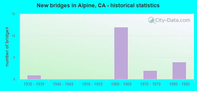
- New bridges - historical statistics
- 11930-1939
- 121960-1969
- 21970-1979
- 41980-1989


- Bridge Condition - Deck
- 84.6%Good
- 7.7%Fair
- 7.7%Poor

- Bridge Condition - Superstructure
- 92.3%Good
- 7.7%Fair

- Bridge Condition - Channel
- 10.0%Excellent
- 30.0%Very good
- 30.0%Good
- 30.0%Satisfactory

- Bridge Condition - Culverts
- 66.7%Good
- 33.3%Satisfactory
Find on map >> Show street view
Structure Number: 57 0019L, Location: 11-SD-008-R31.79 (Lat: 32.833869, Lng: -116.723481), Route carried "on" structure: Interstate 8, Year Built: 1969, Status: Open, Structure Length: 6.13m (20.11ft), Average Daily Traffic: 12,750 (year 2010), Truck Traffic: 7%, Average Future Daily Traffic: 22,526 (year 2044), Design Load: HS 20, Features Intersected: VIEJAS CREEK
Minimum Vertical Clearance: 30+ m (98+ ft), Kilometerpoint: 31.790, Lanes on structure: 2, Base Highway Network: Yes (, Subroute: 1), Owner: State Highway Agency, Approaching Roadway Width: 11.9m (39.0ft), Skew: 2 degrees, Material/Design: Concrete continuous, Design/Construction: Box Beam or Girders - Multiple, Number Of Spans In Main Unit: 3, Length of Maximum Span: 24.4m (80.1ft), Curb-To-Curb Width: 11.9m (39.0ft), Out-to-Out Width: 12.5m (41.0ft)
Condition: Deck: Poor, Superstructure: Good, Substructure: Good, Channel: Very good, Operating Rating: 35.6 metric tons, Method Used To Determine Operating Rating: Load and Resistance Factor Rating (LRFR) rating reported by rating factor(RF) method using HL-93 loadings, Inventory Rating: 27.2 metric tons, Method Used To Determine Inventory Rating: Load and Resistance Factor Rating (LRFR) rating reported by rating factor(RF) method using HL-93 loadings, Structural Evaluation: Equal to present minimum criteria, Deck Geometry: Equal to present minimum criteria, Waterway Adequacy: Superior to present desirable criteria, Approach Roadway Alignment: Equal to present desirable criteria, Length Of Structure Improvement: 6.13m (20.11ft), Designated Inspection Frequency: Every 24 months, Inspection Date: January 2022, Deck Structure Type: Concrete Cast-file-Place, Wearing Surface/Protective System: Wearing Surface: Bituminous
Find on map >> Show street view
Structure Number: 57 0019R, Location: 11-SD-008-R31.78 (Lat: 32.833514, Lng: -116.723669), Route carried "on" structure: Interstate 8, Year Built: 1969, Year Reconstructed: 2002, Status: Open, Structure Length: 6.13m (20.11ft), Average Daily Traffic: 12,750 (year 2009), Truck Traffic: 7%, Average Future Daily Traffic: 22,981 (year 2044), Design Load: HS 20, Features Intersected: VIEJAS CREEK
Minimum Vertical Clearance: 30+ m (98+ ft), Kilometerpoint: 31.780, Lanes on structure: 3, Base Highway Network: Yes (, Subroute: 1), Owner: State Highway Agency, Approaching Roadway Width: 16.9m (55.4ft), Material/Design: Concrete continuous, Design/Construction: Box Beam or Girders - Multiple, Number Of Spans In Main Unit: 3, Length of Maximum Span: 24.4m (80.1ft), Curb-To-Curb Width: 16.9m (55.4ft), Out-to-Out Width: 17.9m (58.7ft)
Condition: Deck: Good, Superstructure: Good, Substructure: Good, Channel: Very good, Operating Rating: 67.7 metric tons, Method Used To Determine Operating Rating: Load Factor (LF), Inventory Rating: 40.8 metric tons, Method Used To Determine Inventory Rating: Load Factor (LF), Structural Evaluation: Better than present minimum criteria, Deck Geometry: Equal to present minimum criteria, Waterway Adequacy: Superior to present desirable criteria, Approach Roadway Alignment: Equal to present desirable criteria, Designated Inspection Frequency: Every 48 months, Inspection Date: January 2022, Deck Structure Type: Concrete Cast-file-Place, Wearing Surface/Protective System: Wearing Surface: Bituminous
Find on map >> Show street view
Structure Number: 57 0528L, Location: 11-SD-008-R26.73 (Lat: 32.848417, Lng: -116.806472), Route carried "on" structure: Interstate 8, Year Built: 1969, Status: Open, Structure Length: 11.16m (36.61ft), Average Daily Traffic: 17,000 (year 2010), Truck Traffic: 7%, Average Future Daily Traffic: 41,500 (year 2037), Design Load: HS 20, Features Intersected: PEUTZ VALLEY RD
Minimum Vertical Clearance: 30+ m (98+ ft), Kilometerpoint: 26.730, Lanes on structure: 2, Lanes under structure: 2, Base Highway Network: Yes (, Subroute: 1), Owner: State Highway Agency, Approaching Roadway Width: 11.9m (39.0ft), Skew: 2 degrees, Material/Design: Prestressed concrete continuous, Design/Construction: Stringer/Multi-beam, Number Of Spans In Main Unit: 3, Length of Maximum Span: 37.2m (122.0ft), Curb-To-Curb Width: 11.9m (39.0ft), Out-to-Out Width: 12.5m (41.0ft)
Condition: Deck: Good, Superstructure: Good, Substructure: Good, Operating Rating: 42.8 metric tons, Method Used To Determine Operating Rating: Load and Resistance Factor Rating (LRFR) rating reported by rating factor(RF) method using HL-93 loadings, Inventory Rating: 23.7 metric tons, Method Used To Determine Inventory Rating: Load and Resistance Factor Rating (LRFR) rating reported by rating factor(RF) method using HL-93 loadings, Structural Evaluation: Somewhat better than minimum adequacy, Deck Geometry: Equal to present minimum criteria, Underclear: Meets minimum limits, Approach Roadway Alignment: Equal to present desirable criteria, Designated Inspection Frequency: Every 24 months, Inspection Date: June 2020, Deck Structure Type: Concrete Cast-file-Place
Find on map >> Show street view
Structure Number: 57 0528R, Location: 11-SD-008-R26.73 (Lat: 32.848175, Lng: -116.806881), Route carried "on" structure: Interstate 8, Year Built: 1969, Year Reconstructed: 2002, Status: Open, Structure Length: 9.20m (30.18ft), Average Daily Traffic: 17,000 (year 2010), Truck Traffic: 7%, Average Future Daily Traffic: 41,500 (year 2037), Design Load: HS 20, Features Intersected: PEUTZ VALLEY RD
Minimum Vertical Clearance: 30+ m (98+ ft), Kilometerpoint: 26.730, Lanes on structure: 3, Lanes under structure: 2, Base Highway Network: Yes (, Subroute: 1), Owner: State Highway Agency, Approaching Roadway Width: 16.0m (52.5ft), Skew: 2 degrees, Material/Design: Prestressed concrete continuous, Design/Construction: Stringer/Multi-beam, Number Of Spans In Main Unit: 3, Length of Maximum Span: 30.8m (101.0ft), Curb-To-Curb Width: 16.0m (52.5ft), Out-to-Out Width: 17.0m (55.8ft)
Condition: Deck: Good, Superstructure: Good, Substructure: Good, Operating Rating: 40.2 metric tons, Method Used To Determine Operating Rating: Load and Resistance Factor Rating (LRFR) rating reported by rating factor(RF) method using HL-93 loadings, Inventory Rating: 19.1 metric tons, Method Used To Determine Inventory Rating: Load and Resistance Factor Rating (LRFR) rating reported by rating factor(RF) method using HL-93 loadings, Structural Evaluation: Meets minimum limits, Deck Geometry: Equal to present minimum criteria, Underclear: Meets minimum limits, Approach Roadway Alignment: Equal to present desirable criteria, Designated Inspection Frequency: Every 24 months, Inspection Date: June 2020, Deck Structure Type: Concrete Cast-file-Place, Wearing Surface/Protective System: Wearing Surface: Bituminous
Find on map >> Show street view
Structure Number: 57 0598, Location: 11-SD-008-R28.46 (Lat: 32.840328, Lng: -116.779881), Route carried "on" structure: County highway , Year Built: 1969, Status: Open, Structure Length: 8.44m (27.69ft), Average Daily Traffic: 9,600 (year 2010), Truck Traffic: 1%, Average Future Daily Traffic: 12,242 (year 2040), Design Load: HS 20, Features Intersected: INTERSTATE 8, Facility Carried by Structure: TAVERN RD
Minimum Vertical Clearance: 30+ m (98+ ft), Kilometerpoint: 0.000, Lanes on structure: 3, Lanes under structure: 5, Owner: State Highway Agency, Approaching Roadway Width: 12.2m (40.0ft), Skew: 2 degrees, Material/Design: Concrete continuous, Design/Construction: Box Beam or Girders - Multiple, Number Of Spans In Main Unit: 4, Length of Maximum Span: 34.7m (113.8ft), Curb-To-Curb Width: 12.2m (40.0ft), Out-to-Out Width: 12.8m (42.0ft)
Condition: Deck: Good, Superstructure: Good, Substructure: Good, Operating Rating: 36.6 metric tons, Method Used To Determine Operating Rating: Load and Resistance Factor Rating (LRFR) rating reported by rating factor(RF) method using HL-93 loadings, Inventory Rating: 28.2 metric tons, Method Used To Determine Inventory Rating: Load and Resistance Factor Rating (LRFR) rating reported by rating factor(RF) method using HL-93 loadings, Structural Evaluation: Better than present minimum criteria, Deck Geometry: Meets minimum limits, Underclear: Equal to present minimum criteria, Approach Roadway Alignment: Equal to present desirable criteria, Designated Inspection Frequency: Every 24 months, Inspection Date: June 2020, Deck Structure Type: Concrete Cast-file-Place
Find on map >> Show street view
Structure Number: 57 0599, Location: 11-SD-008-R29.18 (Lat: 32.839483, Lng: -116.767519), Route carried "on" structure: County highway , Year Built: 1969, Status: Open, Structure Length: 7.83m (25.69ft), Average Daily Traffic: 1,920 (year 2010), Truck Traffic: 1%, Average Future Daily Traffic: 2,500 (year 2037), Design Load: HS 20+Mod, Features Intersected: INTERSTATE 8, Facility Carried by Structure: W VICTORIA DR
Minimum Vertical Clearance: 30+ m (98+ ft), Kilometerpoint: 0.000, Lanes on structure: 2, Lanes under structure: 5, Base Highway Network: Yes, Owner: State Highway Agency, Approaching Roadway Width: 9.2m (30.2ft), Skew: 1 degrees, Material/Design: Concrete continuous, Design/Construction: Box Beam or Girders - Multiple, Number Of Spans In Main Unit: 2, Length of Maximum Span: 40.2m (131.9ft), Curb or Sidewalk Widths: Left: 0.0m, Right: 1.5m (4.9ft), Curb-To-Curb Width: 9.2m (30.2ft), Out-to-Out Width: 11.3m (37.1ft)
Condition: Deck: Good, Superstructure: Fair, Substructure: Good, Operating Rating: 50.5 metric tons, Method Used To Determine Operating Rating: Load and Resistance Factor Rating (LRFR) rating reported by rating factor(RF) method using HL-93 loadings, Inventory Rating: 39.2 metric tons, Method Used To Determine Inventory Rating: Load and Resistance Factor Rating (LRFR) rating reported by rating factor(RF) method using HL-93 loadings, Structural Evaluation: Somewhat better than minimum adequacy, Deck Geometry: Somewhat better than minimum adequacy, Underclear: Equal to present minimum criteria, Approach Roadway Alignment: Equal to present desirable criteria, Designated Inspection Frequency: Every 24 months, Inspection Date: June 2020, Deck Structure Type: Concrete Cast-file-Place, Wearing Surface/Protective System: Wearing Surface: Bituminous
Find on map >> Show street view
Structure Number: 57 0600R, Location: 11-SD-008-R30.17 (Lat: 32.835083, Lng: -116.751239), Route carried "on" structure: Interstate 8, Year Built: 1969, Year Reconstructed: 2002, Status: Open, Structure Length: 3.90m (12.80ft), Average Daily Traffic: 17,000 (year 2010), Truck Traffic: 7%, Average Future Daily Traffic: 43,479 (year 2044), Design Load: HS 20, Features Intersected: VICTORIA DR
Minimum Vertical Clearance: 30+ m (98+ ft), Kilometerpoint: 30.170, Lanes on structure: 3, Lanes under structure: 2, Base Highway Network: Yes (, Subroute: 1), Owner: State Highway Agency, Approaching Roadway Width: 16.9m (55.4ft), Material/Design: Concrete continuous, Design/Construction: Tee Beam, Number Of Spans In Main Unit: 3, Length of Maximum Span: 13.4m (44.0ft), Curb-To-Curb Width: 16.9m (55.4ft), Out-to-Out Width: 17.9m (58.7ft)
Condition: Deck: Good, Superstructure: Good, Substructure: Good, Operating Rating: 38.9 metric tons, Method Used To Determine Operating Rating: Load and Resistance Factor Rating (LRFR) rating reported by rating factor(RF) method using HL-93 loadings, Inventory Rating: 29.8 metric tons, Method Used To Determine Inventory Rating: Load and Resistance Factor Rating (LRFR) rating reported by rating factor(RF) method using HL-93 loadings, Structural Evaluation: Better than present minimum criteria, Deck Geometry: Equal to present minimum criteria, Underclear: Meets minimum limits, Approach Roadway Alignment: Equal to present desirable criteria, Designated Inspection Frequency: Every 24 months, Inspection Date: January 2022, Deck Structure Type: Concrete Cast-file-Place
Find on map >> Show street view
Structure Number: 57 0601, Location: 11-SD-008-R31.34 (Lat: 32.834169, Lng: -116.731178), Route carried "on" structure: County highway , Year Built: 1969, Status: Open, Structure Length: 7.71m (25.30ft), Average Daily Traffic: 5,040 (year 2010), Truck Traffic: 2%, Average Future Daily Traffic: 8,134 (year 2044), Design Load: HS 20, Features Intersected: INTERSTATE 8, Facility Carried by Structure: WILLOWS RD
Minimum Vertical Clearance: 30+ m (98+ ft), Kilometerpoint: 0.000, Lanes on structure: 2, Lanes under structure: 5, Owner: State Highway Agency, Approaching Roadway Width: 8.6m (28.2ft), Material/Design: Concrete continuous, Design/Construction: Box Beam or Girders - Multiple, Number Of Spans In Main Unit: 4, Length of Maximum Span: 30.8m (101.0ft), Curb or Sidewalk Widths: Left: 0.6m (2.0ft), Right: 0.6m (2.0ft), Curb-To-Curb Width: 8.6m (28.2ft), Out-to-Out Width: 10.4m (34.1ft)
Condition: Deck: Good, Superstructure: Good, Substructure: Good, Operating Rating: 43.4 metric tons, Method Used To Determine Operating Rating: Load and Resistance Factor Rating (LRFR) rating reported by rating factor(RF) method using HL-93 loadings, Inventory Rating: 33.4 metric tons, Method Used To Determine Inventory Rating: Load and Resistance Factor Rating (LRFR) rating reported by rating factor(RF) method using HL-93 loadings, Structural Evaluation: Better than present minimum criteria, Deck Geometry: Meets minimum limits, Underclear: Equal to present minimum criteria, Approach Roadway Alignment: Equal to present desirable criteria, Designated Inspection Frequency: Every 24 months, Inspection Date: January 2022, Deck Structure Type: Concrete Cast-file-Place
Find on map >> Show street view
Structure Number: 57C012, Location: 0.8 MI E/O I-8 EXIT 33 (Lat: 32.837456, Lng: -116.717697), Route carried "on" structure: County highway , Year Built: 1933, Status: Open, Structure Length: 12.22m (40.09ft), Average Daily Traffic: 6,575 (year 2019), Truck Traffic: 1%, Average Future Daily Traffic: 10,582 (year 2041), Design Load: H 15, Features Intersected: VIEJAS CREEK, Facility Carried by Structure: WILLOWS RD
Minimum Vertical Clearance: 30+ m (98+ ft), Kilometerpoint: 0.000, Lanes on structure: 2, Owner: County Highway Agency, Approaching Roadway Width: 10.7m (35.1ft), Material/Design: Steel, Design/Construction: Stringer/Multi-beam, Number Of Spans In Main Unit: 10, Length of Maximum Span: 12.2m (40.0ft), Curb-To-Curb Width: 10.4m (34.1ft), Out-to-Out Width: 11.6m (38.1ft)
Condition: Deck: Good, Superstructure: Good, Substructure: Good, Channel: Satisfactory, Operating Rating: 38.2 metric tons, Method Used To Determine Operating Rating: Load Factor (LF), Inventory Rating: 23.0 metric tons, Method Used To Determine Inventory Rating: Load Factor (LF), Structural Evaluation: Somewhat better than minimum adequacy, Deck Geometry: Meets minimum limits, Waterway Adequacy: Equal to present desirable criteria, Approach Roadway Alignment: Equal to present desirable criteria, Designated Inspection Frequency: Every 24 months, Inspection Date: April 2021, Deck Structure Type: Concrete Cast-file-Place
Find on map >> Show street view
Structure Number: 57C0186, Location: 0.45 MI E/O I-8 EXIT 33 (Lat: 32.833269, Lng: -116.723278), Route carried "on" structure: County highway , Year Built: 1969, Status: Open, Structure Length: 4.39m (14.40ft), Average Daily Traffic: 1,500 (year 2016), Truck Traffic: 1%, Average Future Daily Traffic: 1,580 (year 2038), Design Load: HS 20, Features Intersected: VIEJAS CREEK, Facility Carried by Structure: ALPINE BLVD
Minimum Vertical Clearance: 30+ m (98+ ft), Kilometerpoint: 0.000, Lanes on structure: 2, Owner: County Highway Agency, Approaching Roadway Width: 10.1m (33.1ft), Skew: 2 degrees, Material/Design: Concrete continuous, Design/Construction: Box Beam or Girders - Multiple, Number Of Spans In Main Unit: 3, Length of Maximum Span: 24.4m (80.1ft), Curb-To-Curb Width: 9.8m (32.2ft), Out-to-Out Width: 10.4m (34.1ft)
Condition: Deck: Good, Superstructure: Good, Substructure: Good, Channel: Good, Operating Rating: 46.0 metric tons, Method Used To Determine Operating Rating: Load and Resistance Factor Rating (LRFR) rating reported by rating factor(RF) method using HL-93 loadings, Inventory Rating: 35.3 metric tons, Method Used To Determine Inventory Rating: Load and Resistance Factor Rating (LRFR) rating reported by rating factor(RF) method using HL-93 loadings, Structural Evaluation: Better than present minimum criteria, Deck Geometry: Somewhat better than minimum adequacy, Waterway Adequacy: Better than present minimum criteria, Approach Roadway Alignment: Equal to present desirable criteria, Designated Inspection Frequency: Every 48 months, Inspection Date: April 2021, Deck Structure Type: Concrete Cast-file-Place
Find on map >> Show street view
Structure Number: 57C0258, Location: 1.6 MI E/O TAVERN RD (Lat: 32.799897, Lng: -116.749697), Route carried "on" structure: County highway , Year Built: 1973, Status: Open, Structure Length: 8.69m (28.51ft), Average Daily Traffic: 2,738 (year 2016), Truck Traffic: 1%, Average Future Daily Traffic: 3,334 (year 2038), Features Intersected: SWEETWATER RIVER, Facility Carried by Structure: JAPATUL RD
Minimum Vertical Clearance: 30+ m (98+ ft), Kilometerpoint: 0.000, Lanes on structure: 2, Owner: County Highway Agency, Approaching Roadway Width: 12.2m (40.0ft), Material/Design: Concrete continuous, Design/Construction: Box Beam or Girders - Multiple, Number Of Spans In Main Unit: 3, Length of Maximum Span: 29.0m (95.1ft), Curb or Sidewalk Widths: Left: 0.0m, Right: 1.5m (4.9ft), Curb-To-Curb Width: 12.2m (40.0ft), Out-to-Out Width: 14.3m (46.9ft)
Condition: Deck: Good, Superstructure: Good, Substructure: Good, Channel: Good, Operating Rating: 64.5 metric tons, Method Used To Determine Operating Rating: Load and Resistance Factor Rating (LRFR) rating reported by rating factor(RF) method using HL-93 loadings, Inventory Rating: 49.6 metric tons, Method Used To Determine Inventory Rating: Load and Resistance Factor Rating (LRFR) rating reported by rating factor(RF) method using HL-93 loadings, Structural Evaluation: Better than present minimum criteria, Deck Geometry: Equal to present minimum criteria, Waterway Adequacy: Equal to present desirable criteria, Approach Roadway Alignment: Equal to present minimum criteria, Designated Inspection Frequency: Every 48 months, Inspection Date: April 2019, Deck Structure Type: Concrete Cast-file-Place, Wearing Surface/Protective System: Wearing Surface: Monolithic Concrete
Find on map >> Show street view
Structure Number: 57C0259, Location: 2.2 MI E/O TAVERN RD (Lat: 32.794119, Lng: -116.742411), Route carried "on" structure: County highway , Year Built: 1973, Status: Open, Structure Length: 2.50m (8.20ft), Average Daily Traffic: 2,738 (year 2016), Truck Traffic: 3%, Average Future Daily Traffic: 3,334 (year 2038), Features Intersected: PETERSON CYN, Facility Carried by Structure: JAPATUL RD
Minimum Vertical Clearance: 30+ m (98+ ft), Kilometerpoint: 0.000, Lanes on structure: 2, Owner: County Highway Agency, Approaching Roadway Width: 12.2m (40.0ft), Skew: 1 degrees, Material/Design: Concrete, Design/Construction: Box Beam or Girders - Multiple, Number Of Spans In Main Unit: 1, Length of Maximum Span: 24.4m (80.1ft), Curb or Sidewalk Widths: Left: 0.0m, Right: 1.5m (4.9ft), Curb-To-Curb Width: 12.2m (40.0ft), Out-to-Out Width: 14.3m (46.9ft)
Condition: Deck: Fair, Superstructure: Good, Substructure: Good, Channel: Good, Operating Rating: 70.6 metric tons, Method Used To Determine Operating Rating: Load and Resistance Factor Rating (LRFR) rating reported by rating factor(RF) method using HL-93 loadings, Inventory Rating: 54.8 metric tons, Method Used To Determine Inventory Rating: Load and Resistance Factor Rating (LRFR) rating reported by rating factor(RF) method using HL-93 loadings, Structural Evaluation: Better than present minimum criteria, Deck Geometry: Equal to present minimum criteria, Waterway Adequacy: Equal to present desirable criteria, Approach Roadway Alignment: Equal to present desirable criteria, Designated Inspection Frequency: Every 24 months, Inspection Date: April 2021, Deck Structure Type: Concrete Cast-file-Place
Find on map >> Show street view
Structure Number: 57C0372, Location: 2.0 MI N OF RTE I-8 (Lat: 32.855414, Lng: -116.777769), Route carried "on" structure: County highway , Year Built: 1987, Status: Open, Structure Length: 1.28m (4.20ft), Average Daily Traffic: 294 (year 2016), Truck Traffic: 2%, Average Future Daily Traffic: 309 (year 2038), Features Intersected: EL CAPITAN LAKE TRIB, Facility Carried by Structure: PEUTZ VALLEY RD
Minimum Vertical Clearance: 30+ m (98+ ft), Kilometerpoint: 0.000, Lanes on structure: 2, Owner: County Highway Agency, Approaching Roadway Width: 6.1m (20.0ft), Skew: 3 degrees, Material/Design: Concrete, Design/Construction: Slab, Number Of Spans In Main Unit: 1, Length of Maximum Span: 11.6m (38.1ft), Curb-To-Curb Width: 9.6m (31.5ft), Out-to-Out Width: 9.8m (32.2ft)
Condition: Deck: Good, Superstructure: Good, Substructure: Good, Channel: Satisfactory, Operating Rating: 62.9 metric tons, Method Used To Determine Operating Rating: Load Factor (LF), Inventory Rating: 37.6 metric tons, Method Used To Determine Inventory Rating: Load Factor (LF), Structural Evaluation: Better than present minimum criteria, Deck Geometry: Equal to present minimum criteria, Waterway Adequacy: Equal to present desirable criteria, Approach Roadway Alignment: Equal to present desirable criteria, Designated Inspection Frequency: Every 48 months, Inspection Date: April 2021, Deck Structure Type: Concrete Cast-file-Place, Wearing Surface/Protective System: Wearing Surface: Bituminous
Find on map >> Show street view
Structure Number: 57C074, Location: 0.86 MI E/O TAVERN RD (Lat: 32.835428, Lng: -116.763850), Route carried "on" structure: City street , Year Built: 1982, Status: Open, Structure Length: 0.66m (2.17ft), Average Daily Traffic: 13,800 (year 2016), Truck Traffic: 2%, Average Future Daily Traffic: 14,582 (year 2038), Features Intersected: ALPINE CREEK, Facility Carried by Structure: ALPINE BOULEVARD
Minimum Vertical Clearance: 30+ m (98+ ft), Kilometerpoint: 0.000, Lanes on structure: 3, Owner: County Highway Agency, Approaching Roadway Width: 15.0m (49.2ft), Skew: 2 degrees, Material/Design: Concrete, Design/Construction: Culvert, Number Of Spans In Main Unit: 2, Length of Maximum Span: 3.3m (10.8ft), Curb or Sidewalk Widths: Left: 0.3m (1.0ft), Right: 0.0m, Curb-To-Curb Width: 12.3m (40.4ft), Out-to-Out Width: 14.4m (47.2ft)
Condition: Channel: Very good, Culverts: Good, Operating Rating: 54.1 metric tons, Method Used To Determine Operating Rating: Field evaluation and documented engineering judgment, Inventory Rating: 32.4 metric tons, Method Used To Determine Inventory Rating: Field evaluation and documented engineering judgment, Structural Evaluation: Better than present minimum criteria, Deck Geometry: Meets minimum limits, Waterway Adequacy: Equal to present minimum criteria, Approach Roadway Alignment: Equal to present desirable criteria, Designated Inspection Frequency: Every 48 months, Inspection Date: April 2019, Deck Structure Type: Concrete Cast-file-Place, Wearing Surface/Protective System: Wearing Surface: Bituminous
Find on map >> Show street view
Structure Number: 57C0802, Location: 650 FT S/O LAWSON VLY RD (Lat: 32.750097, Lng: -116.759158), Route carried "on" structure: County highway , Year Built: 1983, Status: Open, Structure Length: 1.00m (3.28ft), Average Daily Traffic: 330 (year 2017), Truck Traffic: 1%, Average Future Daily Traffic: 365 (year 2039), Features Intersected: LAWSON CREEK EAST FORK, Facility Carried by Structure: RUDNICK DRIVE
Minimum Vertical Clearance: 30+ m (98+ ft), Kilometerpoint: 0.000, Lanes on structure: 2, Owner: County Highway Agency, Approaching Roadway Width: 9.8m (32.2ft), Skew: 1 degrees, Material/Design: Steel, Design/Construction: Culvert, Number Of Spans In Main Unit: 4, Length of Maximum Span: 2.1m (6.9ft)
Condition: Channel: Excellent, Culverts: Satisfactory, Operating Rating: 54.1 metric tons, Method Used To Determine Operating Rating: Field evaluation and documented engineering judgment, Inventory Rating: 32.4 metric tons, Method Used To Determine Inventory Rating: Field evaluation and documented engineering judgment, Structural Evaluation: Equal to present minimum criteria, Waterway Adequacy: Equal to present desirable criteria, Approach Roadway Alignment: Equal to present desirable criteria, Designated Inspection Frequency: Every 24 months, Inspection Date: September 2021
Find on map >> Show street view
Structure Number: 57C0807, Location: 1 MI E/O S. GRADE RD/2ND (Lat: 32.812836, Lng: -116.746400), Route carried "on" structure: City street , Year Built: 1984, Status: Open, Structure Length: 1.97m (6.46ft), Average Daily Traffic: 130 (year 2016), Truck Traffic: 1%, Average Future Daily Traffic: 250 (year 2038), Features Intersected: VIEJAS CREEK, Facility Carried by Structure: VIA VIEJAS
Minimum Vertical Clearance: 30+ m (98+ ft), Kilometerpoint: 0.000, Lanes on structure: 2, Owner: County Highway Agency, Approaching Roadway Width: 9.4m (30.8ft), Skew: 2 degrees, Material/Design: Steel, Design/Construction: Culvert, Number Of Spans In Main Unit: 2, Length of Maximum Span: 9.7m (31.8ft), Curb or Sidewalk Widths: Left: 0.2m (0.7ft), Right: 0.2m (0.7ft)
Condition: Channel: Satisfactory, Culverts: Good, Operating Rating: 54.1 metric tons, Method Used To Determine Operating Rating: Field evaluation and documented engineering judgment, Inventory Rating: 32.4 metric tons, Method Used To Determine Inventory Rating: Field evaluation and documented engineering judgment, Structural Evaluation: Better than present minimum criteria, Waterway Adequacy: Superior to present desirable criteria, Approach Roadway Alignment: Equal to present minimum criteria, Designated Inspection Frequency: Every 24 months, Inspection Date: April 2021
Find on map >> Show street view
Structure Number: 57 0598, Location: 11-SD-008-R28.46 (Lat: 32.840328, Lng: -116.779881), Route carried "under" structure: Interstate 8, Year Built: 1969, Structure Length: 0. m, Average Daily Traffic: 34,000 (year 2010), Truck Traffic: 7%, Features Intersected: INTERSTATE 8, Facility Carried by Structure: TAVERN RD
Minimum Vertical Clearance: 5.46m (17.91ft), Kilometerpoint: 28.460, Lanes on structure: 3, Lanes under structure: 5, Material/Design: Concrete continuous, Design/Construction: Box Beam or Girders - Multiple, Length of Maximum Span: 34.7m (113.8ft)
Find on map >> Show street view
Structure Number: 57 0599, Location: 11-SD-008-R29.18 (Lat: 32.839483, Lng: -116.767519), Route carried "under" structure: Interstate 8, Year Built: 1969, Structure Length: 0. m, Average Daily Traffic: 34,000 (year 2010), Truck Traffic: 7%, Features Intersected: INTERSTATE 8, Facility Carried by Structure: W VICTORIA DR
Minimum Vertical Clearance: 5.56m (18.24ft), Kilometerpoint: 29.180, Lanes on structure: 2, Lanes under structure: 5, Material/Design: Concrete continuous, Design/Construction: Box Beam or Girders - Multiple, Length of Maximum Span: 40.2m (131.9ft)
Find on map >> Show street view
Structure Number: 57 0601, Location: 11-SD-008-R31.34 (Lat: 32.834169, Lng: -116.731178), Route carried "under" structure: Interstate 8, Year Built: 1969, Structure Length: 0. m, Average Daily Traffic: 34,000 (year 2010), Truck Traffic: 7%, Features Intersected: INTERSTATE 8, Facility Carried by Structure: WILLOWS RD
Minimum Vertical Clearance: 5.41m (17.75ft), Kilometerpoint: 31.340, Lanes on structure: 2, Lanes under structure: 5, Material/Design: Concrete continuous, Design/Construction: Box Beam or Girders - Multiple, Length of Maximum Span: 30.8m (101.0ft)