Bridge Statistics for Bellmawr, New Jersey (NJ)
Condition, Traffic, Stress, Structural Evaluation, Project Costs
- National Bridge Inventory (NBI) Statistics
- 24Number of bridges
- 322ft / 97.8mTotal length
- $3,872,000Total costs
- 1,698,218Total average daily traffic
- 125,923Total average daily truck traffic
- National Bridge Inventory (NBI) Registered Bridges for Bellmawr
- No street view available for this location
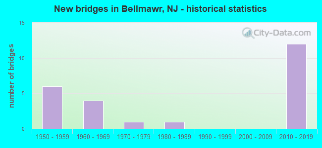
- New bridges - historical statistics
- 61950-1959
- 41960-1969
- 11970-1979
- 11980-1989
- 122010-2019
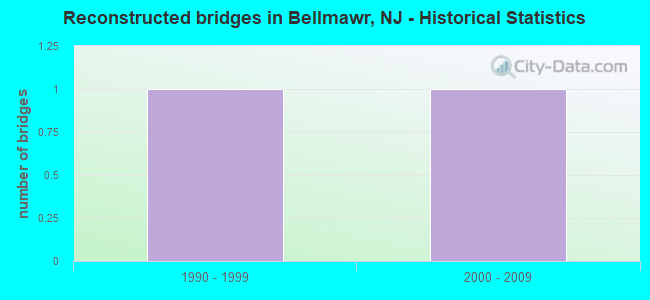
- Reconstructed bridges - Historical Statistics
- 11990-1999
- 12000-2009
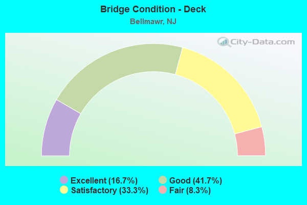
- Bridge Condition - Deck
- 16.7%Excellent
- 41.7%Good
- 33.3%Satisfactory
- 8.3%Fair
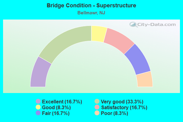
- Bridge Condition - Superstructure
- 16.7%Excellent
- 33.3%Very good
- 8.3%Good
- 16.7%Satisfactory
- 16.7%Fair
- 8.3%Poor
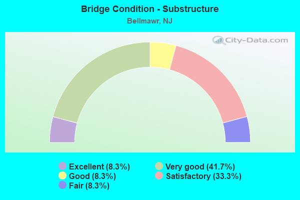
- Bridge Condition - Substructure
- 8.3%Excellent
- 41.7%Very good
- 8.3%Good
- 33.3%Satisfactory
- 8.3%Fair
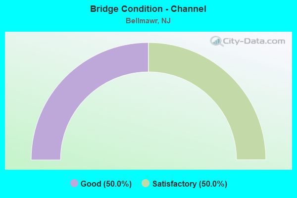
- Bridge Condition - Channel
- 50.0%Good
- 50.0%Satisfactory
Find on map >> Show street view
Structure Number: 412153, Location: 0.1 MI S OF 42-295 JCT (Lat: 39.865311, Lng: -75.101439), Route carried "on" structure: County highway 753, Year Built: 2016, Status: Open, Structure Length: 6.55m (21.49ft), Average Daily Traffic: 11,801 (year 2021), Truck Traffic: 4%, Average Future Daily Traffic: 14,162 (year 2041), Design Load: HL 93, Features Intersected: NJ 42
Minimum Vertical Clearance: 30+ m (98+ ft), Kilometerpoint: 2.575, Lanes on structure: 3, Lanes under structure: 8, Owner: State Highway Agency, Approaching Roadway Width: 13.7m (44.9ft), Skew: 1 degrees, Material/Design: Steel continuous, Design/Construction: Stringer/Multi-beam, Number Of Spans In Main Unit: 2, Length of Maximum Span: 31.7m (104.0ft), Curb or Sidewalk Widths: Left: 1.8m (5.9ft), Right: 2.7m (8.9ft), Curb-To-Curb Width: 13.7m (44.9ft), Out-to-Out Width: 18.9m (62.0ft)
Condition: Deck: Good, Superstructure: Very good, Substructure: Very good, Operating Rating: 54.1 metric tons, Method Used To Determine Operating Rating: Load and Resistance Factor Rating (LRFR) rating reported by rating factor(RF) method using HL-93 loadings, Inventory Rating: 41.8 metric tons, Method Used To Determine Inventory Rating: Load and Resistance Factor Rating (LRFR) rating reported by rating factor(RF) method using HL-93 loadings, Structural Evaluation: Equal to present desirable criteria, Deck Geometry: Somewhat better than minimum adequacy, Underclear: Equal to present minimum criteria, Approach Roadway Alignment: Equal to present desirable criteria, Designated Inspection Frequency: Every 24 months, Inspection Date: June 2021, Deck Structure Type: Concrete Cast-file-Place, Wearing Surface/Protective System: Wearing Surface: Monolithic Concrete, Deck Protection: Epoxy Coated Reinforcing
Find on map >> Show street view
Structure Number: 412155, Location: 0.50 MI N of CR 753 (Lat: 39.866589, Lng: -75.101989), Route carried "on" structure: Interstate 295, Year Built: 2015, Status: Open, Structure Length: 18.96m (62.20ft), Average Daily Traffic: 66,800 (year 2021), Truck Traffic: 9%, Average Future Daily Traffic: 80,160 (year 2041), Design Load: HL 93, Features Intersected: NJ 42
Minimum Vertical Clearance: 30+ m (98+ ft), Kilometerpoint: 42.698, Lanes on structure: 2, Lanes under structure: 6, Base Highway Network: Yes, Owner: State Highway Agency, Approaching Roadway Width: 16.8m (55.1ft), Skew: 9 degrees, Material/Design: Steel, Design/Construction: Stringer/Multi-beam, Number Of Spans In Main Unit: 3, Length of Maximum Span: 69.8m (229.0ft), Curb-To-Curb Width: 16.8m (55.1ft), Out-to-Out Width: 17.8m (58.4ft)
Condition: Deck: Good, Superstructure: Very good, Substructure: Very good, Operating Rating: 45.7 metric tons, Method Used To Determine Operating Rating: Load and Resistance Factor Rating (LRFR) rating reported by rating factor(RF) method using HL-93 loadings, Inventory Rating: 35.3 metric tons, Method Used To Determine Inventory Rating: Load and Resistance Factor Rating (LRFR) rating reported by rating factor(RF) method using HL-93 loadings, Structural Evaluation: Equal to present desirable criteria, Deck Geometry: Superior to present desirable criteria, Underclear: High priority of corrective action, Approach Roadway Alignment: Equal to present desirable criteria, Designated Inspection Frequency: Every 24 months, Critical Feature Inspection Frequency: Every 24 months, Inspection Date: May 2021, Critical Feature Inspection Date: May 2021, Deck Structure Type: Concrete Cast-file-Place, Wearing Surface/Protective System: Wearing Surface: Monolithic Concrete, Deck Protection: Epoxy Coated Reinforcing
Find on map >> Show street view
Structure Number: 426151, Location: AT I-295 JCT (Lat: 39.872669, Lng: -75.082319), Route carried "on" structure: State highway 168, Year Built: 1958, Year Reconstructed: 2013, Status: Open, Structure Length: 4.11m (13.48ft), Average Daily Traffic: 26,536 (year 2021), Truck Traffic: 4%, Average Future Daily Traffic: 32,411 (year 2041), Design Load: HS 20, Features Intersected: I-295
Minimum Vertical Clearance: 30+ m (98+ ft), Kilometerpoint: 11.941, Lanes on structure: 4, Lanes under structure: 8, Base Highway Network: Yes, Owner: State Highway Agency, Approaching Roadway Width: 16.5m (54.1ft), Skew: 1 degrees, Material/Design: Steel, Design/Construction: Stringer/Multi-beam, Number Of Spans In Main Unit: 2, Length of Maximum Span: 19.8m (65.0ft), Curb or Sidewalk Widths: Left: 1.8m (5.9ft), Right: 1.8m (5.9ft), Curb-To-Curb Width: 16.5m (54.1ft), Out-to-Out Width: 20.7m (67.9ft)
Condition: Deck: Good, Superstructure: Good, Substructure: Fair, Operating Rating: 81.6 metric tons, Method Used To Determine Operating Rating: Load Factor (LF), Inventory Rating: 49.0 metric tons, Method Used To Determine Inventory Rating: Load Factor (LF), Structural Evaluation: Somewhat better than minimum adequacy, Deck Geometry: Meets minimum limits, Underclear: Meets minimum limits, Approach Roadway Alignment: Better than present minimum criteria, Designated Inspection Frequency: Every 24 months, Inspection Date: April 2021, Deck Structure Type: Concrete Cast-file-Place, Wearing Surface/Protective System: Wearing Surface: Monolithic Concrete
Find on map >> Show street view
Structure Number: 42715, Location: .4 MI SOUTH OF I-76 (Lat: 39.863331, Lng: -75.110000), Route carried "on" structure: County highway 753, Year Built: 1960, Year Reconstructed: 2003, Status: Closed, Structure Length: 5.33m (17.49ft), Average Daily Traffic: 11,680 (year 2020), Truck Traffic: 4%, Average Future Daily Traffic: 14,251 (year 2040), Design Load: HS 20, Features Intersected: I-295, Facility Carried by Structure: CREEK ROAD
Minimum Vertical Clearance: 30+ m (98+ ft), Kilometerpoint: 1.674, Lanes on structure: 2, Lanes under structure: 6, Owner: State Highway Agency, Approaching Roadway Width: 11.0m (36.1ft), Skew: 1 degrees, Material/Design: Prestressed concrete, Design/Construction: Stringer/Multi-beam, Number Of Spans In Main Unit: 2, Length of Maximum Span: 25.9m (85.0ft), Curb or Sidewalk Widths: Left: 1.8m (5.9ft), Right: 1.8m (5.9ft), Curb-To-Curb Width: 11.0m (36.1ft), Out-to-Out Width: 15.4m (50.5ft)
Condition: Deck: Satisfactory, Superstructure: Fair, Substructure: Satisfactory, Inventory Rating: 47.2 metric tons, Method Used To Determine Inventory Rating: Load Factor (LF), Structural Evaluation: Somewhat better than minimum adequacy, Deck Geometry: Meets minimum limits, Underclear: Meets minimum limits, Approach Roadway Alignment: Equal to present minimum criteria, Designated Inspection Frequency: Every 24 months, Inspection Date: April 2020, Deck Structure Type: Concrete Cast-file-Place, Wearing Surface/Protective System: Wearing Surface: Monolithic Concrete
Find on map >> Show street view
Structure Number: 427154, Location: 0.33 Mi S of Browning Rd. (Lat: 39.867150, Lng: -75.102031), Route carried "on" structure: Ramp Interstate 295, Year Built: 1960, Status: Open, Structure Length: 2.59m (8.50ft), Average Daily Traffic: 91,902 (year 2021), Truck Traffic: 9%, Average Future Daily Traffic: 121,295 (year 2041), Design Load: HS 20+Mod, Features Intersected: NJ 42 SOUTHBOUND
Minimum Vertical Clearance: 30+ m (98+ ft), Kilometerpoint: 42.728, Lanes on structure: 2, Lanes under structure: 4, Base Highway Network: Yes, Owner: State Highway Agency, Approaching Roadway Width: 15.8m (51.8ft), Skew: 33 degrees, Material/Design: Prestressed concrete, Design/Construction: Stringer/Multi-beam, Number Of Spans In Main Unit: 1, Length of Maximum Span: 23.5m (77.1ft), Curb or Sidewalk Widths: Left: 1.2m (3.9ft), Right: 1.2m (3.9ft), Curb-To-Curb Width: 15.8m (51.8ft), Out-to-Out Width: 19.1m (62.7ft)
Condition: Deck: Satisfactory, Superstructure: Fair, Substructure: Satisfactory, Inventory Rating: 54.4 metric tons, Method Used To Determine Inventory Rating: Allowable Stress (AS), Structural Evaluation: Somewhat better than minimum adequacy, Deck Geometry: Superior to present desirable criteria, Underclear: Meets minimum limits, Approach Roadway Alignment: Equal to present minimum criteria, Designated Inspection Frequency: Every 24 months, Inspection Date: April 2021, Deck Structure Type: Concrete Cast-file-Place, Wearing Surface/Protective System: Wearing Surface: Monolithic Concrete
Find on map >> Show street view
Structure Number: 427158, Location: AT I-76 INTERCHANGE (Lat: 39.871669, Lng: -75.101669), Route carried "on" structure: County highway 659, Year Built: 1957, Status: Open, Structure Length: 7.68m (25.20ft), Average Daily Traffic: 3,789 (year 2020), Truck Traffic: 4%, Average Future Daily Traffic: 4,546 (year 2040), Design Load: HS 20+Mod, Features Intersected: I-295
Minimum Vertical Clearance: 30.45m (99.90ft), Kilometerpoint: 1.304, Lanes on structure: 2, Lanes under structure: 13, Owner: State Highway Agency, Approaching Roadway Width: 11.0m (36.1ft), Skew: 3 degrees, Material/Design: Steel, Design/Construction: Stringer/Multi-beam, Number Of Spans In Main Unit: 2, Length of Maximum Span: 36.0m (118.1ft), Curb or Sidewalk Widths: Left: 1.8m (5.9ft), Right: 1.8m (5.9ft), Curb-To-Curb Width: 11.0m (36.1ft), Out-to-Out Width: 15.2m (49.9ft)
Condition: Deck: Satisfactory, Superstructure: Poor, Substructure: Satisfactory, Operating Rating: 68.0 metric tons, Method Used To Determine Operating Rating: Load Factor (LF), Inventory Rating: 40.8 metric tons, Method Used To Determine Inventory Rating: Load Factor (LF), Structural Evaluation: Meets minimum limits, Deck Geometry: Somewhat better than minimum adequacy, Underclear: High priority of replacement, Approach Roadway Alignment: Equal to present desirable criteria, Length Of Structure Improvement: 8.69m (28.51ft), Designated Inspection Frequency: Every 24 months, Inspection Date: April 2020, Bridge Improvement Cost: $579,000, Roadway Improvement Cost: $117,000, Total Project Cost: $910,000 ( Estimate for 2020), Deck Structure Type: Concrete Cast-file-Place, Wearing Surface/Protective System: Wearing Surface: Bituminous
Find on map >> Show street view
Structure Number: 427163, Location: AT I-295/I-76 INTERCHANGE (Lat: 39.865919, Lng: -75.104189), Route carried "on" structure: Interstate 295, Year Built: 2015, Status: Open, Structure Length: 2.62m (8.60ft), Average Daily Traffic: 94,491 (year 2019), Truck Traffic: 9%, Average Future Daily Traffic: 115,297 (year 2039), Design Load: HL 93, Features Intersected: ESSEX AVENUE
Minimum Vertical Clearance: 30+ m (98+ ft), Kilometerpoint: 42.503, Lanes on structure: 8, Lanes under structure: 2, Base Highway Network: Yes, Owner: State Highway Agency, Approaching Roadway Width: 56.2m (184.4ft), Skew: 10 degrees, Material/Design: Steel, Design/Construction: Stringer/Multi-beam, Number Of Spans In Main Unit: 1, Length of Maximum Span: 25.3m (83.0ft), Curb-To-Curb Width: 56.2m (184.4ft), Out-to-Out Width: 59.1m (193.9ft)
Condition: Deck: Excellent, Superstructure: Excellent, Substructure: Very good, Operating Rating: 85.2 metric tons, Method Used To Determine Operating Rating: Load and Resistance Factor Rating (LRFR) rating reported by rating factor(RF) method using HL-93 loadings, Inventory Rating: 65.8 metric tons, Method Used To Determine Inventory Rating: Load and Resistance Factor Rating (LRFR) rating reported by rating factor(RF) method using HL-93 loadings, Structural Evaluation: Equal to present desirable criteria, Deck Geometry: Superior to present desirable criteria, Underclear: Meets minimum limits, Approach Roadway Alignment: Better than present minimum criteria, Designated Inspection Frequency: Every 24 months, Inspection Date: May 2021, Deck Structure Type: Concrete Cast-file-Place, Wearing Surface/Protective System: Wearing Surface: Bituminous, Deck Protection: Epoxy Coated Reinforcing
Find on map >> Show street view
Structure Number: 42815, Location: At I-295/I-76 Interchange (Lat: 39.874400, Lng: -75.100900), Route carried "on" structure: Ramp Interstate 76, Year Built: 2017, Status: Open, Structure Length: 19.42m (63.71ft), Average Daily Traffic: 65,490 (year 2021), Truck Traffic: 4%, Average Future Daily Traffic: 79,910 (year 2041), Design Load: HL 93, Features Intersected: I-76
Minimum Vertical Clearance: 5.72m (18.77ft), Kilometerpoint: 0.209, Lanes on structure: 2, Lanes under structure: 12, Owner: State Highway Agency, Approaching Roadway Width: 15.8m (51.8ft), Material/Design: Steel continuous, Design/Construction: Stringer/Multi-beam, Number Of Spans In Main Unit: 3, Length of Maximum Span: 67.1m (220.1ft), Curb-To-Curb Width: 15.8m (51.8ft), Out-to-Out Width: 16.9m (55.4ft)
Condition: Deck: Good, Superstructure: Very good, Substructure: Very good, Operating Rating: 72.3 metric tons, Method Used To Determine Operating Rating: Load and Resistance Factor Rating (LRFR) rating reported by rating factor(RF) method using HL-93 loadings, Inventory Rating: 55.7 metric tons, Method Used To Determine Inventory Rating: Load and Resistance Factor Rating (LRFR) rating reported by rating factor(RF) method using HL-93 loadings, Structural Evaluation: Equal to present desirable criteria, Deck Geometry: Superior to present desirable criteria, Underclear: Equal to present minimum criteria, Approach Roadway Alignment: Equal to present desirable criteria, Length Of Structure Improvement: 1.90m (6.23ft), Designated Inspection Frequency: Every 24 months, Inspection Date: July 2021, Bridge Improvement Cost: $300,000, Roadway Improvement Cost: $100,000, Total Project Cost: $506,000 ( Estimate for 2015), Deck Structure Type: Concrete Cast-file-Place, Wearing Surface/Protective System: Wearing Surface: Latex Concrete, Membrane: Epoxy, Deck Protection: Epoxy Coated Reinforcing
Find on map >> Show street view
Structure Number: 428154, Location: .8 MI NORTH OF I-76 (Lat: 39.872189, Lng: -75.090681), Route carried "on" structure: County highway 658, Year Built: 2014, Status: Open, Structure Length: 7.83m (25.69ft), Average Daily Traffic: 8,189 (year 2021), Truck Traffic: 3%, Average Future Daily Traffic: 10,002 (year 2041), Design Load: HL 93, Features Intersected: I-295
Minimum Vertical Clearance: 30+ m (98+ ft), Kilometerpoint: 0.467, Lanes on structure: 2, Lanes under structure: 8, Owner: State Highway Agency, Approaching Roadway Width: 11.0m (36.1ft), Skew: 1 degrees, Material/Design: Steel, Design/Construction: Stringer/Multi-beam, Number Of Spans In Main Unit: 2, Length of Maximum Span: 40.2m (131.9ft), Curb or Sidewalk Widths: Left: 1.8m (5.9ft), Right: 1.8m (5.9ft), Curb-To-Curb Width: 11.0m (36.1ft), Out-to-Out Width: 15.2m (49.9ft)
Condition: Deck: Good, Superstructure: Very good, Substructure: Excellent, Operating Rating: 65.4 metric tons, Method Used To Determine Operating Rating: Load and Resistance Factor Rating (LRFR) rating reported by rating factor(RF) method using HL-93 loadings, Inventory Rating: 50.5 metric tons, Method Used To Determine Inventory Rating: Load and Resistance Factor Rating (LRFR) rating reported by rating factor(RF) method using HL-93 loadings, Structural Evaluation: Equal to present desirable criteria, Deck Geometry: Meets minimum limits, Underclear: High priority of corrective action, Approach Roadway Alignment: Equal to present desirable criteria, Designated Inspection Frequency: Every 24 months, Inspection Date: August 2021, Deck Structure Type: Concrete Cast-file-Place, Wearing Surface/Protective System: Deck Protection: Epoxy Coated Reinforcing
Find on map >> Show street view
Structure Number: 42817, Location: AT I-76 INTERCHANGE (Lat: 39.875469, Lng: -75.097850), Route carried "on" structure: Interstate 295, Year Built: 2016, Status: Open, Structure Length: 2.99m (9.81ft), Average Daily Traffic: 47,642 (year 2020), Truck Traffic: 9%, Average Future Daily Traffic: 58,115 (year 2020), Design Load: HL 93, Features Intersected: LITTLE TIMBER CREEK
Minimum Vertical Clearance: 30+ m (98+ ft), Kilometerpoint: 43.855, Lanes on structure: 2, Base Highway Network: Yes, Owner: State Highway Agency, Approaching Roadway Width: 10.4m (34.1ft), Material/Design: Prestressed concrete, Design/Construction: Box Beam or Girders - Multiple, Number Of Spans In Main Unit: 1, Length of Maximum Span: 28.0m (91.9ft), Curb-To-Curb Width: 10.4m (34.1ft), Out-to-Out Width: 11.4m (37.4ft)
Condition: Deck: Excellent, Superstructure: Excellent, Substructure: Very good, Channel: Good, Operating Rating: 42.1 metric tons, Method Used To Determine Operating Rating: Assigned ratings based on Load and Resistance Factor Design (LRFD) reported by rating factor (RF) using HL93 loadings, Inventory Rating: 32.4 metric tons, Method Used To Determine Inventory Rating: Assigned ratings based on Load and Resistance Factor Design (LRFD) reported by rating factor (RF) using HL93 loadings, Structural Evaluation: Equal to present desirable criteria, Deck Geometry: Meets minimum limits, Waterway Adequacy: Superior to present desirable criteria, Approach Roadway Alignment: Equal to present desirable criteria, Designated Inspection Frequency: Every 24 months, Inspection Date: August 2020, Deck Structure Type: Concrete Precast Panels, Wearing Surface/Protective System: Wearing Surface: Bituminous, Deck Protection: Epoxy Coated Reinforcing
Find on map >> Show street view
Structure Number: 2010006, Location: 0.18 MI SO OF US 22 (Lat: 40.671481, Lng: -74.350111), Route carried "on" structure: County highway 613, Year Built: 1985, Status: Open, Structure Length: 0.67m (2.20ft), Average Daily Traffic: 9,146 (year 2020), Truck Traffic: 4%, Average Future Daily Traffic: 10,976 (year 2040), Design Load: HS 20+Mod, Features Intersected: NOMAHEGAN BROOK
Minimum Vertical Clearance: 30+ m (98+ ft), Kilometerpoint: 0.290, Lanes on structure: 3, Owner: County Highway Agency, Approaching Roadway Width: 12.5m (41.0ft), Material/Design: Concrete, Design/Construction: Culvert, Number Of Spans In Main Unit: 1, Length of Maximum Span: 6.7m (22.0ft), Curb or Sidewalk Widths: Left: 3.4m (11.2ft), Right: 1.9m (6.2ft), Curb-To-Curb Width: 12.1m (39.7ft), Out-to-Out Width: 18.4m (60.4ft)
Condition: Channel: Satisfactory, Culverts: Good, Inventory Rating: 55.3 metric tons, Method Used To Determine Inventory Rating: Load Factor (LF), Structural Evaluation: Better than present minimum criteria, Deck Geometry: Meets minimum limits, Waterway Adequacy: Equal to present desirable criteria, Approach Roadway Alignment: Equal to present desirable criteria, Designated Inspection Frequency: Every 24 months, Inspection Date: Febuary 2020
Find on map >> Show street view
Structure Number: 201018, Location: 0.38 MILES W OF NJ 124 (Lat: 40.711631, Lng: -74.324169), Route carried "on" structure: Interstate 78, Year Built: 1974, Status: Open, Structure Length: 13.72m (45.01ft), Average Daily Traffic: 142,540 (year 2019), Truck Traffic: 9%, Average Future Daily Traffic: 173,925 (year 2039), Design Load: HS 20+Mod, Features Intersected: RAMPS EG & NJ 24 EB
Minimum Vertical Clearance: 30+ m (98+ ft), Kilometerpoint: 79.308, Lanes on structure: 6, Lanes under structure: 3, Base Highway Network: Yes, Owner: State Highway Agency, Approaching Roadway Width: 40.2m (131.9ft), Skew: 20 degrees, Material/Design: Steel continuous, Design/Construction: Stringer/Multi-beam, Number Of Spans In Main Unit: 3, Length of Maximum Span: 47.9m (157.2ft), Curb-To-Curb Width: 40.2m (131.9ft), Out-to-Out Width: 42.2m (138.5ft)
Condition: Deck: Fair, Superstructure: Satisfactory, Substructure: Satisfactory, Operating Rating: 65.3 metric tons, Method Used To Determine Operating Rating: Load Factor (LF), Inventory Rating: 39.0 metric tons, Method Used To Determine Inventory Rating: Load Factor (LF), Structural Evaluation: Equal to present minimum criteria, Deck Geometry: Superior to present desirable criteria, Underclear: High priority of corrective action, Approach Roadway Alignment: Equal to present desirable criteria, Length Of Structure Improvement: 13.72m (45.01ft), Designated Inspection Frequency: Every 24 months, Inspection Date: September 2021, Bridge Improvement Cost: $1,767,000, Roadway Improvement Cost: $136,000, Total Project Cost: $2,345,000 ( Estimate for 2019), Deck Structure Type: Concrete Cast-file-Place, Wearing Surface/Protective System: Wearing Surface: Latex Concrete
Find on map >> Show street view
Structure Number: M02403, Location: 2.1 MI SOUTH OF EXIT 3 (Lat: 39.850219, Lng: -75.108864), Route carried "on" structure: County highway 621, Year Built: 1950, Status: Open, Structure Length: 5.30m (17.39ft), Average Daily Traffic: 14,148 (year 2020), Truck Traffic: 4%, Average Future Daily Traffic: 17,262 (year 2040), Design Load: H 20, Features Intersected: NJ TURNPIKE, Facility Carried by Structure: ALMONESSON ROAD
Minimum Vertical Clearance: 30+ m (98+ ft), Kilometerpoint: 7.644, Lanes on structure: 2, Lanes under structure: 4, Owner: State Toll Authority, Approaching Roadway Width: 9.1m (29.9ft), Material/Design: Steel continuous, Design/Construction: Stringer/Multi-beam, Number Of Spans In Main Unit: 4, Length of Maximum Span: 15.5m (50.9ft), Curb or Sidewalk Widths: Left: 1.2m (3.9ft), Right: 1.2m (3.9ft), Curb-To-Curb Width: 9.1m (29.9ft), Out-to-Out Width: 12.2m (40.0ft)
Condition: Deck: Satisfactory, Superstructure: Satisfactory, Substructure: Good, Operating Rating: 32.1 metric tons, Method Used To Determine Operating Rating: Load and Resistance Factor Rating (LRFR) rating reported by rating factor(RF) method using HL-93 loadings, Inventory Rating: 24.6 metric tons, Method Used To Determine Inventory Rating: Load and Resistance Factor Rating (LRFR) rating reported by rating factor(RF) method using HL-93 loadings, Structural Evaluation: Equal to present minimum criteria, Deck Geometry: High priority of corrective action, Underclear: High priority of corrective action, Approach Roadway Alignment: Equal to present desirable criteria, Length Of Structure Improvement: 2.87m (9.42ft), Designated Inspection Frequency: Every 24 months, Inspection Date: March 2020, Bridge Improvement Cost: $66,000, Roadway Improvement Cost: $14,000, Total Project Cost: $111,000 ( Estimate for 2016), Deck Structure Type: Concrete Cast-file-Place, Wearing Surface/Protective System: Wearing Surface: Monolithic Concrete
Find on map >> Show street view
Structure Number: 412153, Location: 0.1 MI S OF 42-295 JCT (Lat: 39.865311, Lng: -75.101439), Route carried "under" structure: State highway 42, Year Built: 2016, Structure Length: 0. m, Average Daily Traffic: 158,895 (year 2021), Truck Traffic: 5%, Features Intersected: NJ 42, Facility Carried by Structure: CR 753
Minimum Vertical Clearance: 5.79m (19.00ft), Kilometerpoint: 22.483, Lanes on structure: 3, Lanes under structure: 8, Material/Design: Steel continuous, Design/Construction: Stringer/Multi-beam, Length of Maximum Span: 31.7m (104.0ft)
Find on map >> Show street view
Structure Number: 412155, Location: 0.50 MI N of CR 753 (Lat: 39.866589, Lng: -75.101989), Route carried "under" structure: State highway 42, Year Built: 2015, Structure Length: 0. m, Average Daily Traffic: 158,895 (year 2021), Truck Traffic: 5%, Features Intersected: NJ 42, Facility Carried by Structure: Route I-295 Ramp E
Minimum Vertical Clearance: 6.55m (21.49ft), Kilometerpoint: 22.820, Lanes on structure: 2, Lanes under structure: 6, Material/Design: Steel, Design/Construction: Stringer/Multi-beam, Length of Maximum Span: 69.8m (229.0ft)
Find on map >> Show street view
Structure Number: 426151, Location: AT I-295 JCT (Lat: 39.872669, Lng: -75.082319), Route carried "under" structure: Interstate 295, Year Built: 1958, Structure Length: 0. m, Average Daily Traffic: 91,692 (year 2021), Truck Traffic: 9%, Features Intersected: I-295, Facility Carried by Structure: RT 168
Minimum Vertical Clearance: 4.85m (15.91ft), Kilometerpoint: 45.319, Lanes on structure: 4, Lanes under structure: 8, Material/Design: Steel, Design/Construction: Stringer/Multi-beam, Length of Maximum Span: 19.8m (65.0ft)
Find on map >> Show street view
Structure Number: 42715, Location: .4 MI SOUTH OF I-76 (Lat: 39.863331, Lng: -75.110000), Route carried "under" structure: Interstate 295, Year Built: 1960, Structure Length: 0. m, Average Daily Traffic: 85,343 (year 2020), Truck Traffic: 9%, Features Intersected: I-295, Facility Carried by Structure: CREEK ROAD
Minimum Vertical Clearance: 4.88m (16.01ft), Kilometerpoint: 41.891, Lanes on structure: 2, Lanes under structure: 6, Material/Design: Prestressed concrete, Design/Construction: Stringer/Multi-beam, Length of Maximum Span: 25.9m (85.0ft)
Find on map >> Show street view
Structure Number: 427154, Location: 0.33 Mi S of Browning Rd. (Lat: 39.867150, Lng: -75.102031), Route carried "under" structure: State highway 42, Year Built: 1960, Structure Length: 0. m, Average Daily Traffic: 80,970 (year 2021), Truck Traffic: 5%, Features Intersected: NJ 42 SOUTHBOUND, Facility Carried by Structure: I-295 RAMPS F & G
Minimum Vertical Clearance: 4.85m (15.91ft), Kilometerpoint: 22.740, Lanes on structure: 2, Lanes under structure: 4, Material/Design: Prestressed concrete, Design/Construction: Stringer/Multi-beam, Length of Maximum Span: 23.5m (77.1ft)
Find on map >> Show street view
Structure Number: 427158, Location: AT I-76 INTERCHANGE (Lat: 39.871669, Lng: -75.101669), Route carried "under" structure: Interstate 295, Year Built: 1957, Structure Length: 0. m, Average Daily Traffic: 88,030 (year 2020), Truck Traffic: 14%, Features Intersected: I-295, Facility Carried by Structure: BROWNING RD(CO659)
Minimum Vertical Clearance: 4.60m (15.09ft), Kilometerpoint: 43.340, Lanes on structure: 2, Lanes under structure: 13, Material/Design: Steel, Design/Construction: Stringer/Multi-beam, Length of Maximum Span: 36.0m (118.1ft)
Find on map >> Show street view
Structure Number: 427163, Location: AT I-295/I-76 INTERCHANGE (Lat: 39.865919, Lng: -75.104189), Route carried "under" structure: City street , Year Built: 2015, Structure Length: 0. m, Average Daily Traffic: 2,284 (year 2019), Truck Traffic: 1%, Features Intersected: ESSEX AVENUE, Facility Carried by Structure: I-295 AND RAMP E
Minimum Vertical Clearance: 4.79m (15.72ft), Kilometerpoint: 0.000, Lanes on structure: 8, Lanes under structure: 2, Material/Design: Steel, Design/Construction: Stringer/Multi-beam, Length of Maximum Span: 25.3m (83.0ft)
Find on map >> Show street view
Structure Number: 42815, Location: At I-295/I-76 Interchange (Lat: 39.874400, Lng: -75.100900), Route carried "under" structure: Interstate 76, Year Built: 2017, Structure Length: 0. m, Average Daily Traffic: 193,900 (year 2021), Truck Traffic: 9%, Features Intersected: I-76
Minimum Vertical Clearance: 5.72m (18.77ft), Kilometerpoint: 0.209, Lanes on structure: 2, Lanes under structure: 10, Material/Design: Steel continuous, Design/Construction: Stringer/Multi-beam, Length of Maximum Span: 67.1m (220.1ft)
Find on map >> Show street view
Structure Number: 42815, Location: At I-295/I-76 Interchange (Lat: 39.874400, Lng: -75.100900), Route carried "under" structure: Ramp Interstate 295, Year Built: 2017, Structure Length: 0. m, Average Daily Traffic: 59,000 (year 2017), Features Intersected: I-76, Facility Carried by Structure: I-76 Ramp "D"
Minimum Vertical Clearance: 8.96m (29.40ft), Kilometerpoint: 43.935, Lanes on structure: 2, Lanes under structure: 2, Material/Design: Steel continuous, Design/Construction: Stringer/Multi-beam, Length of Maximum Span: 67.1m (220.1ft)
Find on map >> Show street view
Structure Number: 428154, Location: .8 MI NORTH OF I-76 (Lat: 39.872189, Lng: -75.090681), Route carried "under" structure: Interstate 295, Year Built: 2014, Structure Length: 0. m, Average Daily Traffic: 128,997 (year 2021), Truck Traffic: 9%, Features Intersected: I-295, Facility Carried by Structure: BELL ROAD (CR 658)
Minimum Vertical Clearance: 5.49m (18.01ft), Kilometerpoint: 44.595, Lanes on structure: 2, Lanes under structure: 8, Material/Design: Steel, Design/Construction: Stringer/Multi-beam, Length of Maximum Span: 40.2m (131.9ft)
Find on map >> Show street view
Structure Number: M02403, Location: 2.1 MI SOUTH OF EXIT 3 (Lat: 39.850219, Lng: -75.108864), Route carried "under" structure: Other road NJTPK, Year Built: 1950, Structure Length: 0. m, Average Daily Traffic: 56,058 (year 2020), Truck Traffic: 5%, Features Intersected: NJ TURNPIKE, Facility Carried by Structure: ALMONESSON ROAD
Minimum Vertical Clearance: 4.55m (14.93ft), Kilometerpoint: 39.107, Lanes on structure: 2, Lanes under structure: 4, Toll: On toll road, Material/Design: Steel continuous, Design/Construction: Stringer/Multi-beam, Length of Maximum Span: 15.5m (50.9ft)