Bridge Statistics for Brambleton, Virginia (VA)
Condition, Traffic, Stress, Structural Evaluation, Project Costs
- National Bridge Inventory (NBI) Statistics
- 11Number of bridges
- 66ft / 19.9mTotal length
- $498,000Total costs
- 65,044Total average daily traffic
- 1,709Total average daily truck traffic
- 82,112Total future (year 2031) average daily traffic
- National Bridge Inventory (NBI) Registered Bridges for Brambleton
- No street view available for this location
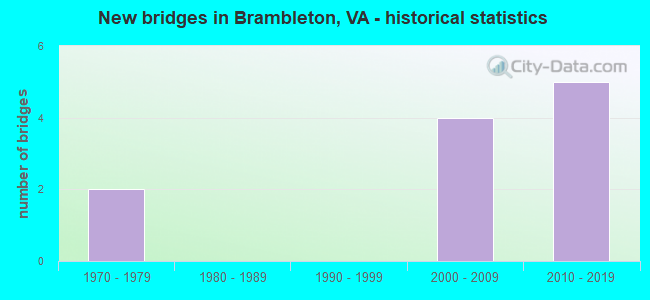
- New bridges - historical statistics
- 21970-1979
- 42000-2009
- 52010-2019


- Bridge Condition - Superstructure
- 50.0%Very good
- 50.0%Good

- Bridge Condition - Channel
- 18.2%Very good
- 45.5%Good
- 18.2%Satisfactory
- 18.2%Fair

- Bridge Condition - Culverts
- 22.2%Very good
- 55.6%Good
- 22.2%Satisfactory
Find on map >> Show street view
Structure Number: 11179, Location: 01.50FR616/00.50TO659 (Lat: 38.959633, Lng: -77.543722), Route carried "on" structure: County highway 621, Year Built: 1973, Status: Open, Structure Length: 1.31m (4.30ft), Average Daily Traffic: 5,170 (year 2020), Truck Traffic: 5%, Average Future Daily Traffic: 7,238 (year 2040), Design Load: HS 20, Features Intersected: NORTH FORK OF BROAD RUN, Facility Carried by Structure: EVERGREEN MILLS RD
Minimum Vertical Clearance: 30+ m (98+ ft), Kilometerpoint: 10.764, Lanes on structure: 2, Owner: State Highway Agency, Approaching Roadway Width: 7.0m (23.0ft), Skew: 1 degrees, Material/Design: Concrete, Design/Construction: Culvert, Number Of Spans In Main Unit: 4, Length of Maximum Span: 3.0m (9.8ft)
Condition: Channel: Fair, Culverts: Satisfactory, Operating Rating: 73.5 metric tons, Method Used To Determine Operating Rating: Load Factor (LF), Inventory Rating: 43.5 metric tons, Method Used To Determine Inventory Rating: Load Factor (LF), Structural Evaluation: Equal to present minimum criteria, Waterway Adequacy: Meets minimum limits, Approach Roadway Alignment: Somewhat better than minimum adequacy, Length Of Structure Improvement: 5.12m (16.80ft), Designated Inspection Frequency: Every 24 months, Inspection Date: June 2021, Bridge Improvement Cost: $44,000, Roadway Improvement Cost: $66,000, Total Project Cost: $125,000 ( Estimate for 2015)
Find on map >> Show street view
Structure Number: 11221, Location: 00.20FR621/01.09TO774 (Lat: 38.959197, Lng: -77.537547), Route carried "on" structure: County highway 659, Year Built: 1971, Status: Open, Structure Length: 1.28m (4.20ft), Average Daily Traffic: 9,417 (year 2020), Truck Traffic: 4%, Average Future Daily Traffic: 13,184 (year 2040), Design Load: HS 20, Features Intersected: NORTH FORK BROAD RUN, Facility Carried by Structure: BELMONT RIDGE ROAD
Minimum Vertical Clearance: 30+ m (98+ ft), Kilometerpoint: 12.872, Lanes on structure: 2, Owner: State Highway Agency, Approaching Roadway Width: 6.7m (22.0ft), Material/Design: Concrete, Design/Construction: Culvert, Number Of Spans In Main Unit: 4, Length of Maximum Span: 3.0m (9.8ft)
Condition: Channel: Fair, Culverts: Satisfactory, Operating Rating: 89.8 metric tons, Method Used To Determine Operating Rating: Field evaluation and documented engineering judgment, Inventory Rating: 65.3 metric tons, Method Used To Determine Inventory Rating: Field evaluation and documented engineering judgment, Structural Evaluation: Equal to present minimum criteria, Waterway Adequacy: Somewhat better than minimum adequacy, Approach Roadway Alignment: Better than present minimum criteria, Length Of Structure Improvement: 5.12m (16.80ft), Designated Inspection Frequency: Every 24 months, Inspection Date: June 2021, Bridge Improvement Cost: $44,000, Roadway Improvement Cost: $59,000, Total Project Cost: $125,000
Find on map >> Show street view
Structure Number: 26626, Location: 00.53FR659/02.23TO267 (Lat: 38.988958, Lng: -77.516567), Route carried "on" structure: County highway 772, Year Built: 2000, Status: Open, Structure Length: 0.79m (2.59ft), Average Daily Traffic: 11,591 (year 2020), Truck Traffic: 2%, Average Future Daily Traffic: 16,227 (year 2040), Design Load: HS 20, Features Intersected: TRIB. OF BROAD RUN, Facility Carried by Structure: RYAN ROAD
Minimum Vertical Clearance: 30+ m (98+ ft), Kilometerpoint: 4.103, Lanes on structure: 4, Owner: State Highway Agency, Approaching Roadway Width: 8.5m (27.9ft), Skew: 1 degrees, Material/Design: Concrete, Design/Construction: Culvert, Number Of Spans In Main Unit: 3, Length of Maximum Span: 2.4m (7.9ft)
Condition: Channel: Good, Culverts: Good, Operating Rating: 86.2 metric tons, Method Used To Determine Operating Rating: Load and Resistance Factor (LRFR), Inventory Rating: 51.7 metric tons, Method Used To Determine Inventory Rating: Load and Resistance Factor (LRFR), Structural Evaluation: Better than present minimum criteria, Waterway Adequacy: Better than present minimum criteria, Approach Roadway Alignment: Equal to present desirable criteria, Length Of Structure Improvement: 9.51m (31.20ft), Designated Inspection Frequency: Every 24 months, Inspection Date: January 2021, Bridge Improvement Cost: $45,000, Roadway Improvement Cost: $55,000, Total Project Cost: $120,000 ( Estimate for 2015)
Find on map >> Show street view
Structure Number: 27946, Location: 00.20FR772/00.20TO STILL (Lat: 38.991572, Lng: -77.519406), Route carried "on" structure: City street 2450, Year Built: 2000, Status: Open, Structure Length: 0.67m (2.20ft), Average Daily Traffic: 600 (year 2008), Average Future Daily Traffic: 984 (year 2040), Design Load: HS 20+Mod, Features Intersected: TRIB.OF BROAD RUN, Facility Carried by Structure: FOREST MANOR DR.
Minimum Vertical Clearance: 30.18m (99.02ft), Kilometerpoint: 0.000, Lanes on structure: 2, Owner: State Highway Agency, Approaching Roadway Width: 9.8m (32.2ft), Skew: 3 degrees, Material/Design: Concrete, Design/Construction: Culvert, Number Of Spans In Main Unit: 2, Length of Maximum Span: 3.0m (9.8ft), Curb or Sidewalk Widths: Left: 0.4m (1.3ft), Right: 0.0m
Condition: Channel: Very good, Culverts: Good, Operating Rating: 75.9 metric tons, Method Used To Determine Operating Rating: Load Factor (LF), Inventory Rating: 44.9 metric tons, Method Used To Determine Inventory Rating: Load Factor (LF), Structural Evaluation: Better than present minimum criteria, Waterway Adequacy: Equal to present desirable criteria, Approach Roadway Alignment: Superior to present desirable criteria, Designated Inspection Frequency: Every 24 months, Inspection Date: August 2020
Find on map >> Show street view
Structure Number: 29597, Location: 00.00FR0000/00.62TO0621 (Lat: 38.963833, Lng: -77.559617), Route carried "on" structure: County highway 2315, Year Built: 2011, Status: Open, Structure Length: 3.95m (12.96ft), Average Daily Traffic: 1,000 (year 2011), Average Future Daily Traffic: 2,500 (year 2035), Design Load: HS 20+Mod, Features Intersected: North Fork Broad Run, Facility Carried by Structure: Founders Dr.
Minimum Vertical Clearance: 30.45m (99.90ft), Kilometerpoint: 0.000, Lanes on structure: 2, Owner: State Highway Agency, Approaching Roadway Width: 12.2m (40.0ft), Material/Design: Steel, Design/Construction: Truss - Thru, Number Of Spans In Main Unit: 1, Length of Maximum Span: 38.4m (126.0ft), Curb or Sidewalk Widths: Left: 0.0m, Right: 1.8m (5.9ft), Curb-To-Curb Width: 12.2m (40.0ft), Out-to-Out Width: 14.9m (48.9ft)
Condition: Deck: Good, Superstructure: Good, Substructure: Good, Channel: Satisfactory, Operating Rating: 71.7 metric tons, Method Used To Determine Operating Rating: Load and Resistance Factor (LRFR), Inventory Rating: 42.9 metric tons, Method Used To Determine Inventory Rating: Load and Resistance Factor (LRFR), Structural Evaluation: Better than present minimum criteria, Deck Geometry: Equal to present desirable criteria, Waterway Adequacy: Equal to present desirable criteria, Approach Roadway Alignment: Equal to present desirable criteria, Length Of Structure Improvement: 0.30m (0.98ft), Designated Inspection Frequency: Every 24 months, Critical Feature Inspection Frequency: Every 24 months, Inspection Date: May 2020, Critical Feature Inspection Date: May 2020, Bridge Improvement Cost: $1,000, Roadway Improvement Cost: $1,000, Total Project Cost: $3,000 ( Estimate for 2015), Deck Structure Type: Concrete Cast-file-Place, Wearing Surface/Protective System: Wearing Surface: Monolithic Concrete, Deck Protection: Epoxy Coated Reinforcing
Find on map >> Show street view
Structure Number: 29612, Location: 00.46fr2315 0.28to3571 (Lat: 38.959953, Lng: -77.554869), Route carried "on" structure: County highway 3020, Year Built: 2014, Status: Open, Structure Length: 3.41m (11.19ft), Average Daily Traffic: 500 (year 2014), Truck Traffic: 1%, Average Future Daily Traffic: 1,800 (year 2034), Design Load: HS 20, Features Intersected: Lenah Run, Facility Carried by Structure: BLOOMFIELD PATH
Minimum Vertical Clearance: 30.18m (99.02ft), Kilometerpoint: 0.000, Lanes on structure: 2, Owner: State Highway Agency, Approaching Roadway Width: 8.2m (26.9ft), Material/Design: Steel, Design/Construction: Truss - Thru, Number Of Spans In Main Unit: 1, Length of Maximum Span: 33.5m (109.9ft), Curb or Sidewalk Widths: Left: 2.4m (7.9ft), Right: 0.0m, Curb-To-Curb Width: 7.3m (24.0ft), Out-to-Out Width: 11.2m (36.7ft)
Condition: Deck: Good, Superstructure: Very good, Substructure: Good, Channel: Good, Operating Rating: 57.8 metric tons, Method Used To Determine Operating Rating: Load and Resistance Factor (LRFR), Inventory Rating: 44.5 metric tons, Method Used To Determine Inventory Rating: Load and Resistance Factor (LRFR), Structural Evaluation: Better than present minimum criteria, Deck Geometry: Meets minimum limits, Waterway Adequacy: Equal to present minimum criteria, Approach Roadway Alignment: Equal to present minimum criteria, Designated Inspection Frequency: Every 24 months, Critical Feature Inspection Frequency: Every 24 months, Inspection Date: January 2021, Critical Feature Inspection Date: January 2021, Deck Structure Type: Concrete Cast-file-Place, Wearing Surface/Protective System: Wearing Surface: Monolithic Concrete, Deck Protection: Epoxy Coated Reinforcing
Find on map >> Show street view
Structure Number: 30232, Location: 00.39frShrev 0.10toFresh (Lat: 38.968256, Lng: -77.533153), Route carried "on" structure: Alternate County highway 659, Year Built: 2013, Status: Open, Structure Length: 1.10m (3.61ft), Average Daily Traffic: 9,417 (year 2020), Truck Traffic: 4%, Average Future Daily Traffic: 13,184 (year 2040), Design Load: HS 20, Features Intersected: Cain Branch, Facility Carried by Structure: BELMONT RIDGE ROAD
Minimum Vertical Clearance: 30.18m (99.02ft), Kilometerpoint: 0.000, Lanes on structure: 5, Owner: State Highway Agency, Approaching Roadway Width: 8.2m (26.9ft), Material/Design: Concrete, Design/Construction: Culvert, Number Of Spans In Main Unit: 3, Length of Maximum Span: 3.7m (12.1ft), Curb or Sidewalk Widths: Left: 1.2m (3.9ft), Right: 2.4m (7.9ft)
Condition: Channel: Good, Culverts: Good, Operating Rating: 68.9 metric tons, Method Used To Determine Operating Rating: Load Factor (LF), Inventory Rating: 40.8 metric tons, Method Used To Determine Inventory Rating: Load Factor (LF), Structural Evaluation: Better than present minimum criteria, Waterway Adequacy: Better than present minimum criteria, Approach Roadway Alignment: Better than present minimum criteria, Designated Inspection Frequency: Every 24 months, Inspection Date: July 2021
Find on map >> Show street view
Structure Number: 30408, Location: 0.30frRyan 0.82toBelmont (Lat: 38.991350, Lng: -77.535864), Route carried "on" structure: Alternate County highway 3171, Year Built: 2004, Status: Open, Structure Length: 0.67m (2.20ft), Average Daily Traffic: 1,800 (year 2012), Truck Traffic: 2%, Average Future Daily Traffic: 4,200 (year 2031), Design Load: HS 20, Features Intersected: Wetlands, Facility Carried by Structure: Rte.659 Northstar
Minimum Vertical Clearance: 30.18m (99.02ft), Kilometerpoint: 0.000, Lanes on structure: 4, Owner: State Highway Agency, Approaching Roadway Width: 8.5m (27.9ft), Material/Design: Concrete, Design/Construction: Culvert, Number Of Spans In Main Unit: 2, Length of Maximum Span: 3.0m (9.8ft), Curb or Sidewalk Widths: Left: 0.0m, Right: 1.5m (4.9ft), Curb-To-Curb Width: 7.3m (24.0ft), Out-to-Out Width: 7.3m (24.0ft)
Condition: Channel: Good, Culverts: Good, Operating Rating: 77.7 metric tons, Method Used To Determine Operating Rating: Load and Resistance Factor (LRFR), Inventory Rating: 59.9 metric tons, Method Used To Determine Inventory Rating: Load and Resistance Factor (LRFR), Structural Evaluation: Better than present minimum criteria, Deck Geometry: High priority of replacement, Waterway Adequacy: Equal to present minimum criteria, Approach Roadway Alignment: Better than present minimum criteria, Designated Inspection Frequency: Every 24 months, Inspection Date: June 2020
Find on map >> Show street view
Structure Number: 30409, Location: .80FRRyanRd.20TOBelmtrdge (Lat: 38.996806, Lng: -77.530592), Route carried "on" structure: County highway 3171, Year Built: 2004, Status: Open, Structure Length: 4.57m (14.99ft), Average Daily Traffic: 10,638 (year 2018), Truck Traffic: 4%, Average Future Daily Traffic: 1,400 (year 2034), Design Load: HS 20, Features Intersected: WETLANDS
Minimum Vertical Clearance: 30.18m (99.02ft), Kilometerpoint: 0.000, Lanes on structure: 4, Owner: State Highway Agency, Approaching Roadway Width: 18.9m (62.0ft), Material/Design: Concrete, Design/Construction: Culvert, Number Of Spans In Main Unit: 2, Length of Maximum Span: 3.0m (9.8ft), Curb-To-Curb Width: 18.3m (60.0ft), Out-to-Out Width: 45.7m (149.9ft)
Condition: Channel: Satisfactory, Culverts: Good, Operating Rating: 80.8 metric tons, Method Used To Determine Operating Rating: Load and Resistance Factor (LRFR), Inventory Rating: 62.4 metric tons, Method Used To Determine Inventory Rating: Load and Resistance Factor (LRFR), Structural Evaluation: Better than present minimum criteria, Deck Geometry: Somewhat better than minimum adequacy, Waterway Adequacy: Equal to present minimum criteria, Approach Roadway Alignment: Equal to present desirable criteria, Designated Inspection Frequency: Every 24 months, Inspection Date: June 2020
Find on map >> Show street view
Structure Number: 30422, Location: 0.01fr Ryan 0.40 to Beav (Lat: 38.991628, Lng: -77.557083), Route carried "on" structure: County highway 2474, Year Built: 2012, Status: Open, Structure Length: 0.85m (2.79ft), Average Daily Traffic: 200 (year 2014), Truck Traffic: 1%, Average Future Daily Traffic: 800 (year 2034), Design Load: HS 20, Features Intersected: Trib of Beaverdam Creek, Facility Carried by Structure: Conservancy Dr.
Minimum Vertical Clearance: 30.18m (99.02ft), Kilometerpoint: 0.000, Lanes on structure: 2, Owner: State Highway Agency, Approaching Roadway Width: 8.2m (26.9ft), Material/Design: Concrete, Design/Construction: Culvert, Number Of Spans In Main Unit: 4, Length of Maximum Span: 1.8m (5.9ft)
Condition: Channel: Good, Culverts: Very good, Operating Rating: 62.6 metric tons, Method Used To Determine Operating Rating: Load Factor (LF), Inventory Rating: 37.2 metric tons, Method Used To Determine Inventory Rating: Load Factor (LF), Structural Evaluation: Equal to present desirable criteria, Waterway Adequacy: Better than present minimum criteria, Approach Roadway Alignment: Equal to present minimum criteria, Designated Inspection Frequency: Every 24 months, Inspection Date: July 2020
Find on map >> Show street view
Structure Number: 31203, Location: 00.10fr772 00.90to645 (Lat: 38.989792, Lng: -77.518033), Route carried "on" structure: County highway 901, Year Built: 2018, Status: Open, Structure Length: 1.34m (4.40ft), Average Daily Traffic: 14,711 (year 2020), Average Future Daily Traffic: 20,595 (year 2040), Design Load: HS 20, Features Intersected: TRIB. OF BROAD RUN, Facility Carried by Structure: CLAIBORNE PKWY
Minimum Vertical Clearance: 30+ m (98+ ft), Kilometerpoint: 0.000, Lanes on structure: 5, Owner: State Highway Agency, Approaching Roadway Width: 9.1m (29.9ft), Skew: 2 degrees, Material/Design: Concrete, Design/Construction: Culvert, Number Of Spans In Main Unit: 4, Length of Maximum Span: 3.2m (10.5ft)
Condition: Channel: Very good, Culverts: Very good, Operating Rating: 54.5 metric tons, Method Used To Determine Operating Rating: Load and Resistance Factor (LRFR), Inventory Rating: 42.1 metric tons, Method Used To Determine Inventory Rating: Load and Resistance Factor (LRFR), Structural Evaluation: Equal to present desirable criteria, Waterway Adequacy: Equal to present desirable criteria, Approach Roadway Alignment: Equal to present desirable criteria, Length Of Structure Improvement: 14.81m (48.59ft), Designated Inspection Frequency: Every 24 months, Inspection Date: January 2022, Bridge Improvement Cost: $39,000, Roadway Improvement Cost: $69,000, Total Project Cost: $125,000