Bridge Statistics for Branford, Connecticut (CT)
Condition, Traffic, Stress, Structural Evaluation, Project Costs
- National Bridge Inventory (NBI) Statistics
- 45Number of bridges
- 295ft / 89.8mTotal length
- $10,910,000Total costs
- 1,511,893Total average daily traffic
- 158,879Total average daily truck traffic
- National Bridge Inventory (NBI) Registered Bridges for Branford
- No street view available for this location
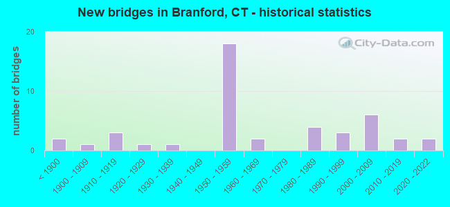
- New bridges - historical statistics
- 2Before 1900
- 11900-1909
- 31910-1919
- 11920-1929
- 11930-1939
- 181950-1959
- 21960-1969
- 41980-1989
- 31990-1999
- 62000-2009
- 22010-2019
- 22020-2022

- Reconstructed bridges - Historical Statistics
- 21960-1969
- 01970-1979
- 51980-1989
- 31990-1999
- 12000-2009


- Bridge Condition - Deck
- 6.7%Very good
- 50.0%Good
- 33.3%Satisfactory
- 6.7%Fair
- 3.3%Poor

- Bridge Condition - Superstructure
- 3.3%Very good
- 53.3%Good
- 36.7%Satisfactory
- 6.7%Fair

- Bridge Condition - Substructure
- 10.0%Very good
- 63.3%Good
- 20.0%Satisfactory
- 6.7%Fair

- Bridge Condition - Channel
- 22.2%Very good
- 55.6%Good
- 11.1%Satisfactory
- 11.1%Fair
Find on map >> Show street view
Structure Number: 19, Location: 0.2 M EAST OF I95,EXIT 5 (Lat: 41.042336, Lng: -73.574378), Route carried "on" structure: Interstate 95, Year Built: 1958, Status: Open, Structure Length: 2.04m (6.69ft), Average Daily Traffic: 139,300 (year 2017), Truck Traffic: 10%, Average Future Daily Traffic: 206,986 (year 2037), Design Load: HS 20, Features Intersected: SOUND BEACH AVENUE
Minimum Vertical Clearance: 30+ m (98+ ft), Kilometerpoint: 9.270, Lanes on structure: 7, Lanes under structure: 3, Base Highway Network: Yes, Owner: State Highway Agency, Approaching Roadway Width: 40.2m (131.9ft), Skew: 30 degrees, Material/Design: Steel, Design/Construction: Stringer/Multi-beam, Number Of Spans In Main Unit: 1, Length of Maximum Span: 18.3m (60.0ft), Curb-To-Curb Width: 40.2m (131.9ft), Out-to-Out Width: 43.2m (141.7ft)
Condition: Deck: Satisfactory, Superstructure: Satisfactory, Substructure: Satisfactory, Operating Rating: 85.4 metric tons, Method Used To Determine Operating Rating: Load Factor (LF), Inventory Rating: 51.2 metric tons, Method Used To Determine Inventory Rating: Load Factor (LF), Structural Evaluation: Equal to present minimum criteria, Deck Geometry: Superior to present desirable criteria, Underclear: Meets minimum limits, Approach Roadway Alignment: Equal to present desirable criteria, Designated Inspection Frequency: Every 24 months, Inspection Date: October 2020, Deck Structure Type: Concrete Cast-file-Place, Wearing Surface/Protective System: Wearing Surface: Bituminous, Membrane: Preformed Fabric
Find on map >> Show street view
Structure Number: 183, Location: 0.6 MI N OF US ROUTE 1 (Lat: 41.283439, Lng: -72.870253), Route carried "on" structure: Interstate 95, Year Built: 1958, Year Reconstructed: 2005, Status: Open, Structure Length: 2.56m (8.40ft), Average Daily Traffic: 93,700 (year 2017), Truck Traffic: 14%, Average Future Daily Traffic: 139,229 (year 2037), Design Load: HS 20, Features Intersected: ROUTE 100
Minimum Vertical Clearance: 30+ m (98+ ft), Kilometerpoint: 81.320, Lanes on structure: 6, Lanes under structure: 4, Base Highway Network: Yes, Owner: State Highway Agency, Approaching Roadway Width: 36.0m (118.1ft), Skew: 30 degrees, Material/Design: Steel, Design/Construction: Stringer/Multi-beam, Number Of Spans In Main Unit: 1, Length of Maximum Span: 23.5m (77.1ft), Curb-To-Curb Width: 36.0m (118.1ft), Out-to-Out Width: 38.9m (127.6ft)
Condition: Deck: Good, Superstructure: Good, Substructure: Good, Operating Rating: 75.4 metric tons, Method Used To Determine Operating Rating: Load Factor (LF), Inventory Rating: 45.2 metric tons, Method Used To Determine Inventory Rating: Load Factor (LF), Structural Evaluation: Better than present minimum criteria, Deck Geometry: Superior to present desirable criteria, Underclear: High priority of corrective action, Approach Roadway Alignment: Equal to present desirable criteria, Designated Inspection Frequency: Every 24 months, Inspection Date: June 2020, Deck Structure Type: Concrete Cast-file-Place, Wearing Surface/Protective System: Wearing Surface: Bituminous, Membrane: Built-up, Deck Protection: Epoxy Coated Reinforcing
Find on map >> Show street view
Structure Number: 187, Location: 0.5 MI N OF US ROUTE 1 (Lat: 41.283406, Lng: -72.851756), Route carried "on" structure: City street , Year Built: 1958, Status: Open, Structure Length: 5.06m (16.60ft), Average Daily Traffic: 444 (year 2019), Truck Traffic: 4%, Average Future Daily Traffic: 660 (year 2039), Design Load: HS 20, Features Intersected: INTERSTATE-95, Facility Carried by Structure: HOSLEY AVENUE
Minimum Vertical Clearance: 30+ m (98+ ft), Kilometerpoint: 0.708, Lanes on structure: 2, Lanes under structure: 6, Owner: State Highway Agency, Approaching Roadway Width: 12.2m (40.0ft), Skew: 4 degrees, Material/Design: Steel, Design/Construction: Stringer/Multi-beam, Number Of Spans In Main Unit: 2, Length of Maximum Span: 24.4m (80.1ft), Curb or Sidewalk Widths: Left: 0.5m (1.6ft), Right: 0.5m (1.6ft), Curb-To-Curb Width: 12.2m (40.0ft), Out-to-Out Width: 13.9m (45.6ft)
Condition: Deck: Satisfactory, Superstructure: Satisfactory, Substructure: Good, Operating Rating: 55.7 metric tons, Method Used To Determine Operating Rating: Load and Resistance Factor Rating (LRFR) rating reported by rating factor(RF) method using HL-93 loadings, Inventory Rating: 43.1 metric tons, Method Used To Determine Inventory Rating: Load and Resistance Factor Rating (LRFR) rating reported by rating factor(RF) method using HL-93 loadings, Structural Evaluation: Equal to present minimum criteria, Deck Geometry: Equal to present desirable criteria, Underclear: High priority of corrective action, Approach Roadway Alignment: Equal to present minimum criteria, Designated Inspection Frequency: Every 24 months, Inspection Date: July 2020, Deck Structure Type: Concrete Cast-file-Place, Wearing Surface/Protective System: Wearing Surface: Bituminous, Membrane: Preformed Fabric
Find on map >> Show street view
Structure Number: 188, Location: 1.0 MI W OF US ROUTE 1 (Lat: 41.285683, Lng: -72.836639), Route carried "on" structure: Interstate 95, Year Built: 1958, Year Reconstructed: 1992, Status: Open, Structure Length: 1.57m (5.15ft), Average Daily Traffic: 89,200 (year 2017), Truck Traffic: 9%, Average Future Daily Traffic: 132,542 (year 2037), Design Load: H 20, Features Intersected: SR 794 WESTBOUND
Minimum Vertical Clearance: 30+ m (98+ ft), Kilometerpoint: 84.217, Lanes on structure: 8, Lanes under structure: 1, Base Highway Network: Yes, Owner: State Highway Agency, Approaching Roadway Width: 43.9m (144.0ft), Skew: 32 degrees, Material/Design: Steel, Design/Construction: Stringer/Multi-beam, Number Of Spans In Main Unit: 1, Length of Maximum Span: 14.0m (45.9ft), Curb-To-Curb Width: 44.4m (145.7ft), Out-to-Out Width: 47.7m (156.5ft)
Condition: Deck: Good, Superstructure: Good, Substructure: Good, Operating Rating: 76.3 metric tons, Method Used To Determine Operating Rating: Load Factor (LF), Inventory Rating: 45.8 metric tons, Method Used To Determine Inventory Rating: Load Factor (LF), Structural Evaluation: Better than present minimum criteria, Deck Geometry: Superior to present desirable criteria, Underclear: Meets minimum limits, Approach Roadway Alignment: Equal to present desirable criteria, Designated Inspection Frequency: Every 24 months, Inspection Date: December 2020, Deck Structure Type: Concrete Cast-file-Place, Wearing Surface/Protective System: Wearing Surface: Bituminous, Membrane: Preformed Fabric, Deck Protection: Epoxy Coated Reinforcing
Find on map >> Show street view
Structure Number: 189, Location: 0.5 MI N OF US ROUTE 1 (Lat: 41.287022, Lng: -72.828222), Route carried "on" structure: City street , Year Built: 1958, Status: Open, Structure Length: 5.21m (17.09ft), Average Daily Traffic: 1,103 (year 2019), Truck Traffic: 2%, Average Future Daily Traffic: 1,639 (year 2039), Design Load: H 20, Features Intersected: INTERSTATE-95, Facility Carried by Structure: CHERRY HILL ROAD
Minimum Vertical Clearance: 30+ m (98+ ft), Kilometerpoint: 1.191, Lanes on structure: 2, Lanes under structure: 6, Owner: State Highway Agency, Approaching Roadway Width: 12.5m (41.0ft), Skew: 1 degrees, Material/Design: Steel, Design/Construction: Stringer/Multi-beam, Number Of Spans In Main Unit: 2, Length of Maximum Span: 25.3m (83.0ft), Curb or Sidewalk Widths: Left: 1.5m (4.9ft), Right: 0.0m, Curb-To-Curb Width: 12.5m (41.0ft), Out-to-Out Width: 15.0m (49.2ft)
Condition: Deck: Satisfactory, Superstructure: Satisfactory, Substructure: Satisfactory, Operating Rating: 51.2 metric tons, Method Used To Determine Operating Rating: Load and Resistance Factor Rating (LRFR) rating reported by rating factor(RF) method using HL-93 loadings, Inventory Rating: 39.2 metric tons, Method Used To Determine Inventory Rating: Load and Resistance Factor Rating (LRFR) rating reported by rating factor(RF) method using HL-93 loadings, Structural Evaluation: Equal to present minimum criteria, Deck Geometry: Better than present minimum criteria, Underclear: High priority of corrective action, Approach Roadway Alignment: Equal to present desirable criteria, Designated Inspection Frequency: Every 24 months, Inspection Date: May 2020, Deck Structure Type: Concrete Cast-file-Place, Wearing Surface/Protective System: Wearing Surface: Bituminous, Membrane: Built-up
Find on map >> Show street view
Structure Number: 19, Location: 0.3 MI N OF US ROUTE 1 (Lat: 41.287808, Lng: -72.823031), Route carried "on" structure: City street , Year Built: 2002, Status: Open, Structure Length: 7.62m (25.00ft), Average Daily Traffic: 752 (year 2019), Truck Traffic: 2%, Average Future Daily Traffic: 1,117 (year 2039), Design Load: HS 20, Features Intersected: INTERSTATE-95 & RAMP 171, Facility Carried by Structure: TODDS HILL ROAD
Minimum Vertical Clearance: 30+ m (98+ ft), Kilometerpoint: 0.467, Lanes on structure: 2, Lanes under structure: 6, Owner: State Highway Agency, Approaching Roadway Width: 9.1m (29.9ft), Skew: 2 degrees, Material/Design: Steel continuous, Design/Construction: Stringer/Multi-beam, Number Of Spans In Main Unit: 2, Length of Maximum Span: 36.9m (121.1ft), Curb or Sidewalk Widths: Left: 0.0m, Right: 1.7m (5.6ft), Curb-To-Curb Width: 9.2m (30.2ft), Out-to-Out Width: 11.8m (38.7ft)
Condition: Deck: Good, Superstructure: Good, Substructure: Good, Operating Rating: 26.9 metric tons, Method Used To Determine Operating Rating: Load and Resistance Factor Rating (LRFR) rating reported by rating factor(RF) method using HL-93 loadings, Inventory Rating: 20.7 metric tons, Method Used To Determine Inventory Rating: Load and Resistance Factor Rating (LRFR) rating reported by rating factor(RF) method using HL-93 loadings, Structural Evaluation: Somewhat better than minimum adequacy, Deck Geometry: Equal to present minimum criteria, Underclear: Equal to present minimum criteria, Approach Roadway Alignment: Equal to present minimum criteria, Designated Inspection Frequency: Every 24 months, Inspection Date: May 2020, Deck Structure Type: Concrete Cast-file-Place, Wearing Surface/Protective System: Wearing Surface: Monolithic Concrete, Deck Protection: Epoxy Coated Reinforcing
Find on map >> Show street view
Structure Number: 191, Location: 0.2 MI N OF US ROUTE 1 (Lat: 41.288333, Lng: -72.819619), Route carried "on" structure: Interstate 95, Year Built: 1958, Year Reconstructed: 1990, Status: Open, Structure Length: 2.90m (9.51ft), Average Daily Traffic: 76,900 (year 2017), Truck Traffic: 14%, Average Future Daily Traffic: 114,266 (year 2037), Design Load: H 20, Features Intersected: SR 740 (CEDAR STREET)
Minimum Vertical Clearance: 30+ m (98+ ft), Kilometerpoint: 85.665, Lanes on structure: 4, Lanes under structure: 5, Base Highway Network: Yes, Owner: State Highway Agency, Approaching Roadway Width: 29.9m (98.1ft), Skew: 30 degrees, Material/Design: Steel, Design/Construction: Stringer/Multi-beam, Number Of Spans In Main Unit: 1, Length of Maximum Span: 27.4m (89.9ft), Curb-To-Curb Width: 29.6m (97.1ft), Out-to-Out Width: 31.6m (103.7ft)
Condition: Deck: Good, Superstructure: Good, Substructure: Good, Operating Rating: 59.0 metric tons, Method Used To Determine Operating Rating: Load and Resistance Factor Rating (LRFR) rating reported by rating factor(RF) method using HL-93 loadings, Inventory Rating: 45.4 metric tons, Method Used To Determine Inventory Rating: Load and Resistance Factor Rating (LRFR) rating reported by rating factor(RF) method using HL-93 loadings, Structural Evaluation: Better than present minimum criteria, Deck Geometry: Superior to present desirable criteria, Underclear: High priority of corrective action, Approach Roadway Alignment: Equal to present desirable criteria, Designated Inspection Frequency: Every 24 months, Inspection Date: April 2020, Deck Structure Type: Concrete Cast-file-Place, Wearing Surface/Protective System: Wearing Surface: Bituminous, Membrane: Preformed Fabric, Deck Protection: Epoxy Coated Reinforcing
Find on map >> Show street view
Structure Number: 193, Location: 0.1 MI N OF US ROUTE 1 (Lat: 41.291939, Lng: -72.805997), Route carried "on" structure: Interstate 95, Year Built: 1958, Year Reconstructed: 1990, Status: Open, Structure Length: 1.83m (6.00ft), Average Daily Traffic: 87,200 (year 2017), Truck Traffic: 9%, Average Future Daily Traffic: 129,570 (year 2037), Design Load: H 20, Features Intersected: CHESTNUT STREET
Minimum Vertical Clearance: 30+ m (98+ ft), Kilometerpoint: 86.872, Lanes on structure: 4, Lanes under structure: 2, Base Highway Network: Yes, Owner: State Highway Agency, Approaching Roadway Width: 29.6m (97.1ft), Skew: 32 degrees, Material/Design: Steel, Design/Construction: Stringer/Multi-beam, Number Of Spans In Main Unit: 1, Length of Maximum Span: 17.1m (56.1ft), Curb-To-Curb Width: 29.5m (96.8ft), Out-to-Out Width: 31.6m (103.7ft)
Condition: Deck: Good, Superstructure: Good, Substructure: Good, Operating Rating: 58.0 metric tons, Method Used To Determine Operating Rating: Load and Resistance Factor Rating (LRFR) rating reported by rating factor(RF) method using HL-93 loadings, Inventory Rating: 44.7 metric tons, Method Used To Determine Inventory Rating: Load and Resistance Factor Rating (LRFR) rating reported by rating factor(RF) method using HL-93 loadings, Structural Evaluation: Better than present minimum criteria, Deck Geometry: Superior to present desirable criteria, Underclear: Somewhat better than minimum adequacy, Approach Roadway Alignment: Equal to present desirable criteria, Designated Inspection Frequency: Every 24 months, Inspection Date: May 2021, Deck Structure Type: Concrete Cast-file-Place, Wearing Surface/Protective System: Wearing Surface: Bituminous, Membrane: Preformed Fabric, Deck Protection: Epoxy Coated Reinforcing
Find on map >> Show street view
Structure Number: 194, Location: 0.1 MI N OF US ROUTE 1 (Lat: 41.293383, Lng: -72.796875), Route carried "on" structure: Interstate 95, Year Built: 1958, Status: Open, Structure Length: 1.65m (5.41ft), Average Daily Traffic: 87,200 (year 2017), Truck Traffic: 9%, Average Future Daily Traffic: 129,570 (year 2037), Design Load: H 20, Features Intersected: MILL PLAIN ROAD
Minimum Vertical Clearance: 30+ m (98+ ft), Kilometerpoint: 87.661, Lanes on structure: 4, Lanes under structure: 2, Base Highway Network: Yes, Owner: State Highway Agency, Approaching Roadway Width: 29.0m (95.1ft), Skew: 31 degrees, Material/Design: Steel, Design/Construction: Stringer/Multi-beam, Number Of Spans In Main Unit: 1, Length of Maximum Span: 14.9m (48.9ft), Curb-To-Curb Width: 29.0m (95.1ft), Out-to-Out Width: 31.6m (103.7ft)
Condition: Deck: Satisfactory, Superstructure: Good, Substructure: Good, Operating Rating: 58.6 metric tons, Method Used To Determine Operating Rating: Load and Resistance Factor Rating (LRFR) rating reported by rating factor(RF) method using HL-93 loadings, Inventory Rating: 45.0 metric tons, Method Used To Determine Inventory Rating: Load and Resistance Factor Rating (LRFR) rating reported by rating factor(RF) method using HL-93 loadings, Structural Evaluation: Better than present minimum criteria, Deck Geometry: Superior to present desirable criteria, Underclear: High priority of corrective action, Approach Roadway Alignment: Equal to present desirable criteria, Designated Inspection Frequency: Every 24 months, Inspection Date: March 2021, Deck Structure Type: Concrete Cast-file-Place, Wearing Surface/Protective System: Wearing Surface: Bituminous, Membrane: Preformed Fabric
Find on map >> Show street view
Structure Number: 195, Location: 0.6 MI S OF US ROUTE 1 (Lat: 41.293603, Lng: -72.795467), Route carried "on" structure: Interstate 95, Year Built: 1958, Status: Open, Structure Length: 1.04m (3.41ft), Average Daily Traffic: 85,300 (year 2015), Truck Traffic: 10%, Average Future Daily Traffic: 126,747 (year 2035), Design Load: H 20, Features Intersected: BRANFORD RIVER
Minimum Vertical Clearance: 30+ m (98+ ft), Kilometerpoint: 87.790, Lanes on structure: 4, Base Highway Network: Yes, Owner: State Highway Agency, Approaching Roadway Width: 28.7m (94.2ft), Skew: 30 degrees, Material/Design: Concrete continuous, Design/Construction: Culvert, Number Of Spans In Main Unit: 2, Length of Maximum Span: 4.9m (16.1ft)
Condition: Channel: Good, Culverts: Good, Structural Evaluation: Better than present minimum criteria, Waterway Adequacy: Superior to present desirable criteria, Approach Roadway Alignment: Equal to present desirable criteria, Designated Inspection Frequency: Every 48 months, Inspection Date: July 2019
Find on map >> Show street view
Structure Number: 196, Location: AT I-95 EXIT NO. 55 (Lat: 41.294072, Lng: -72.783406), Route carried "on" structure: Interstate 95, Year Built: 2020, Status: Open, Structure Length: 4.21m (13.81ft), Average Daily Traffic: 67,300 (year 2020), Truck Traffic: 9%, Average Future Daily Traffic: 100,001 (year 2040), Design Load: HL 93, Features Intersected: US ROUTE 1
Minimum Vertical Clearance: 30+ m (98+ ft), Kilometerpoint: 88.804, Lanes on structure: 4, Lanes under structure: 4, Base Highway Network: Yes, Owner: State Highway Agency, Approaching Roadway Width: 29.5m (96.8ft), Skew: 32 degrees, Material/Design: Steel, Design/Construction: Stringer/Multi-beam, Number Of Spans In Main Unit: 2, Length of Maximum Span: 19.5m (64.0ft), Curb-To-Curb Width: 29.5m (96.8ft), Out-to-Out Width: 31.6m (103.7ft)
Condition: Deck: Good, Superstructure: Good, Substructure: Good, Operating Rating: 97.2 metric tons, Method Used To Determine Operating Rating: Load and Resistance Factor Rating (LRFR) rating reported by rating factor(RF) method using HL-93 loadings, Inventory Rating: 87.8 metric tons, Method Used To Determine Inventory Rating: Load and Resistance Factor Rating (LRFR) rating reported by rating factor(RF) method using HL-93 loadings, Structural Evaluation: Better than present minimum criteria, Deck Geometry: Superior to present desirable criteria, Underclear: Equal to present minimum criteria, Approach Roadway Alignment: Equal to present desirable criteria, Designated Inspection Frequency: Every 24 months, Inspection Date: December 2020, Deck Structure Type: Concrete Cast-file-Place, Wearing Surface/Protective System: Wearing Surface: Bituminous, Membrane: Other
Find on map >> Show street view
Structure Number: 197, Location: 0.3 MI S OF US ROUTE 1 (Lat: 41.293742, Lng: -72.776242), Route carried "on" structure: City street , Year Built: 1958, Year Reconstructed: 1993, Status: Open, Structure Length: 5.52m (18.11ft), Average Daily Traffic: 3,100 (year 2019), Truck Traffic: 2%, Average Future Daily Traffic: 4,606 (year 2039), Design Load: HS 20, Features Intersected: INTERSTATE-95, Facility Carried by Structure: FEATHERBED LANE
Minimum Vertical Clearance: 30+ m (98+ ft), Kilometerpoint: 1.062, Lanes on structure: 2, Lanes under structure: 4, Owner: State Highway Agency, Approaching Roadway Width: 12.2m (40.0ft), Skew: 2 degrees, Material/Design: Steel, Design/Construction: Stringer/Multi-beam, Number Of Spans In Main Unit: 2, Length of Maximum Span: 27.4m (89.9ft), Curb or Sidewalk Widths: Left: 1.5m (4.9ft), Right: 1.5m (4.9ft), Curb-To-Curb Width: 12.2m (40.0ft), Out-to-Out Width: 16.1m (52.8ft)
Condition: Deck: Good, Superstructure: Satisfactory, Substructure: Good, Operating Rating: 60.6 metric tons, Method Used To Determine Operating Rating: Load and Resistance Factor Rating (LRFR) rating reported by rating factor(RF) method using HL-93 loadings, Inventory Rating: 46.7 metric tons, Method Used To Determine Inventory Rating: Load and Resistance Factor Rating (LRFR) rating reported by rating factor(RF) method using HL-93 loadings, Structural Evaluation: Equal to present minimum criteria, Deck Geometry: Equal to present minimum criteria, Underclear: High priority of corrective action, Approach Roadway Alignment: Equal to present desirable criteria, Designated Inspection Frequency: Every 24 months, Inspection Date: May 2020, Deck Structure Type: Concrete Cast-file-Place, Wearing Surface/Protective System: Wearing Surface: Bituminous, Membrane: Preformed Fabric, Deck Protection: Epoxy Coated Reinforcing
Find on map >> Show street view
Structure Number: 198, Location: 0.6 MI N OF US ROUTE 1 (Lat: 41.294197, Lng: -72.773000), Route carried "on" structure: Interstate 95, Year Built: 1958, Year Reconstructed: 1990, Status: Open, Structure Length: 2.90m (9.51ft), Average Daily Traffic: 81,800 (year 2017), Truck Traffic: 14%, Average Future Daily Traffic: 121,547 (year 2037), Design Load: HS 20, Features Intersected: BRANFORD STEAM RAILROAD
Minimum Vertical Clearance: 30+ m (98+ ft), Kilometerpoint: 89.689, Lanes on structure: 4, Base Highway Network: Yes, Owner: State Highway Agency, Approaching Roadway Width: 29.9m (98.1ft), Skew: 31 degrees, Material/Design: Steel, Design/Construction: Stringer/Multi-beam, Number Of Spans In Main Unit: 1, Length of Maximum Span: 27.4m (89.9ft), Curb-To-Curb Width: 29.6m (97.1ft), Out-to-Out Width: 31.6m (103.7ft)
Condition: Deck: Good, Superstructure: Satisfactory, Substructure: Satisfactory, Operating Rating: 65.4 metric tons, Method Used To Determine Operating Rating: Load and Resistance Factor Rating (LRFR) rating reported by rating factor(RF) method using HL-93 loadings, Inventory Rating: 50.2 metric tons, Method Used To Determine Inventory Rating: Load and Resistance Factor Rating (LRFR) rating reported by rating factor(RF) method using HL-93 loadings, Structural Evaluation: Equal to present minimum criteria, Deck Geometry: Superior to present desirable criteria, Underclear: High priority of corrective action, Approach Roadway Alignment: Equal to present desirable criteria, Designated Inspection Frequency: Every 24 months, Inspection Date: January 2020, Deck Structure Type: Concrete Cast-file-Place, Wearing Surface/Protective System: Wearing Surface: Bituminous, Membrane: Preformed Fabric, Deck Protection: Epoxy Coated Reinforcing
Find on map >> Show street view
Structure Number: 199, Location: 0.3 MI S OF US ROUTE 1 (Lat: 41.295536, Lng: -72.763489), Route carried "on" structure: City street , Year Built: 2003, Status: Open, Structure Length: 6.55m (21.49ft), Average Daily Traffic: 5,851 (year 2019), Truck Traffic: 3%, Average Future Daily Traffic: 8,694 (year 2039), Design Load: HS 20, Features Intersected: INTERSTATE-95, Facility Carried by Structure: LEETES ISLAND ROAD
Minimum Vertical Clearance: 30+ m (98+ ft), Kilometerpoint: 5.021, Lanes on structure: 5, Lanes under structure: 4, Owner: State Highway Agency, Approaching Roadway Width: 21.3m (69.9ft), Skew: 3 degrees, Material/Design: Steel continuous, Design/Construction: Stringer/Multi-beam, Number Of Spans In Main Unit: 2, Length of Maximum Span: 33.5m (109.9ft), Curb or Sidewalk Widths: Left: 1.7m (5.6ft), Right: 1.7m (5.6ft), Curb-To-Curb Width: 21.3m (69.9ft), Out-to-Out Width: 25.5m (83.7ft)
Condition: Deck: Good, Superstructure: Good, Substructure: Good, Operating Rating: 88.5 metric tons, Method Used To Determine Operating Rating: Load Factor (LF), Inventory Rating: 53.2 metric tons, Method Used To Determine Inventory Rating: Load Factor (LF), Structural Evaluation: Better than present minimum criteria, Deck Geometry: Somewhat better than minimum adequacy, Underclear: Equal to present minimum criteria, Approach Roadway Alignment: Equal to present desirable criteria, Designated Inspection Frequency: Every 24 months, Inspection Date: May 2020, Deck Structure Type: Concrete Cast-file-Place, Wearing Surface/Protective System: Wearing Surface: Bituminous, Membrane: Built-up, Deck Protection: Epoxy Coated Reinforcing
Find on map >> Show street view
Structure Number: 326, Location: 0.5 MI S OF I-95 (Lat: 41.198631, Lng: -73.125122), Route carried "on" structure: US 1, Year Built: 1933, Status: Open, Structure Length: 7.56m (24.80ft), Average Daily Traffic: 17,400 (year 2016), Truck Traffic: 6%, Average Future Daily Traffic: 25,855 (year 2036), Design Load: H 20, Features Intersected: METRO NORTH RAILROAD
Minimum Vertical Clearance: 30+ m (98+ ft), Kilometerpoint: 55.555, Lanes on structure: 4, Base Highway Network: Yes, Owner: State Highway Agency, Approaching Roadway Width: 13.7m (44.9ft), Skew: 4 degrees, Material/Design: Steel continuous, Design/Construction: Stringer/Multi-beam, Number Of Spans In Main Unit: 3, Length of Maximum Span: 25.6m (84.0ft), Curb or Sidewalk Widths: Left: 1.5m (4.9ft), Right: 1.5m (4.9ft), Curb-To-Curb Width: 13.7m (44.9ft), Out-to-Out Width: 17.7m (58.1ft)
Condition: Deck: Poor, Superstructure: Satisfactory, Substructure: Fair, Operating Rating: 64.1 metric tons, Method Used To Determine Operating Rating: Load Factor (LF), Inventory Rating: 38.5 metric tons, Method Used To Determine Inventory Rating: Load Factor (LF), Structural Evaluation: Somewhat better than minimum adequacy, Deck Geometry: High priority of replacement, Underclear: Meets minimum limits, Approach Roadway Alignment: Equal to present minimum criteria, Designated Inspection Frequency: Every 24 months, Inspection Date: January 2021, Total Project Cost: $10,910,000, Deck Structure Type: Concrete Cast-file-Place, Wearing Surface/Protective System: Wearing Surface: Bituminous
Find on map >> Show street view
Structure Number: 341, Location: 0.5 MI S OF I-95 (Lat: 41.292572, Lng: -72.792494), Route carried "on" structure: US 1, Year Built: 1958, Year Reconstructed: 1989, Status: Open, Structure Length: 2.35m (7.71ft), Average Daily Traffic: 15,500 (year 2016), Truck Traffic: 4%, Average Future Daily Traffic: 23,031 (year 2036), Design Load: HS 20, Features Intersected: BRANFORD RIVER
Minimum Vertical Clearance: 30+ m (98+ ft), Kilometerpoint: 90.606, Lanes on structure: 2, Base Highway Network: Yes, Owner: State Highway Agency, Approaching Roadway Width: 12.2m (40.0ft), Material/Design: Steel, Design/Construction: Stringer/Multi-beam, Number Of Spans In Main Unit: 1, Length of Maximum Span: 22.3m (73.2ft), Curb or Sidewalk Widths: Left: 0.0m, Right: 1.5m (4.9ft), Curb-To-Curb Width: 12.4m (40.7ft), Out-to-Out Width: 15.0m (49.2ft)
Condition: Deck: Good, Superstructure: Good, Substructure: Good, Channel: Very good, Operating Rating: 59.9 metric tons, Method Used To Determine Operating Rating: Load and Resistance Factor Rating (LRFR) rating reported by rating factor(RF) method using HL-93 loadings, Inventory Rating: 46.0 metric tons, Method Used To Determine Inventory Rating: Load and Resistance Factor Rating (LRFR) rating reported by rating factor(RF) method using HL-93 loadings, Structural Evaluation: Better than present minimum criteria, Deck Geometry: Somewhat better than minimum adequacy, Waterway Adequacy: Equal to present minimum criteria, Approach Roadway Alignment: Equal to present desirable criteria, Designated Inspection Frequency: Every 24 months, Inspection Date: April 2021, Deck Structure Type: Concrete Cast-file-Place, Wearing Surface/Protective System: Wearing Surface: Bituminous, Membrane: Preformed Fabric, Deck Protection: Epoxy Coated Reinforcing
Find on map >> Show street view
Structure Number: 574, Location: 0.4 MI N OF ROUTE 34 (Lat: 41.324692, Lng: -73.085097), Route carried "on" structure: State highway 8, Year Built: 1951, Year Reconstructed: 1985, Status: Open, Structure Length: 1.86m (6.10ft), Average Daily Traffic: 73,900 (year 2018), Truck Traffic: 5%, Average Future Daily Traffic: 109,808 (year 2038), Design Load: HS 20, Features Intersected: ABANDONED RAILROAD
Minimum Vertical Clearance: 30+ m (98+ ft), Kilometerpoint: 21.259, Lanes on structure: 6, Base Highway Network: Yes, Owner: State Highway Agency, Approaching Roadway Width: 32.3m (106.0ft), Skew: 34 degrees, Material/Design: Steel, Design/Construction: Stringer/Multi-beam, Number Of Spans In Main Unit: 1, Length of Maximum Span: 16.8m (55.1ft), Curb-To-Curb Width: 32.2m (105.6ft), Out-to-Out Width: 34.3m (112.5ft)
Condition: Deck: Fair, Superstructure: Good, Substructure: Good, Operating Rating: 53.1 metric tons, Method Used To Determine Operating Rating: Load and Resistance Factor Rating (LRFR) rating reported by rating factor(RF) method using HL-93 loadings, Inventory Rating: 41.1 metric tons, Method Used To Determine Inventory Rating: Load and Resistance Factor Rating (LRFR) rating reported by rating factor(RF) method using HL-93 loadings, Structural Evaluation: Better than present minimum criteria, Deck Geometry: Superior to present desirable criteria, Approach Roadway Alignment: Equal to present desirable criteria, Designated Inspection Frequency: Every 24 months, Inspection Date: September 2020, Deck Structure Type: Concrete Cast-file-Place, Wearing Surface/Protective System: Wearing Surface: Bituminous, Membrane: Preformed Fabric
Find on map >> Show street view
Structure Number: 1358, Location: 0.3 MI N OF US ROUTE 1 (Lat: 41.299936, Lng: -72.780275), Route carried "on" structure: State highway 139, Year Built: 2017, Status: Open, Structure Length: 1.64m (5.38ft), Average Daily Traffic: 9,500 (year 2016), Truck Traffic: 4%, Average Future Daily Traffic: 14,116 (year 2036), Design Load: HL 93, Features Intersected: BRANFORD RIVER
Minimum Vertical Clearance: 30+ m (98+ ft), Kilometerpoint: 0.435, Lanes on structure: 2, Owner: State Highway Agency, Approaching Roadway Width: 9.8m (32.2ft), Material/Design: Prestressed concrete, Design/Construction: Slab, Number Of Spans In Main Unit: 2, Length of Maximum Span: 15.9m (52.2ft), Curb-To-Curb Width: 9.8m (32.2ft), Out-to-Out Width: 10.9m (35.8ft)
Condition: Deck: Very good, Superstructure: Very good, Substructure: Very good, Channel: Good, Operating Rating: 71.9 metric tons, Method Used To Determine Operating Rating: Load and Resistance Factor Rating (LRFR) rating reported by rating factor(RF) method using HL-93 loadings, Inventory Rating: 55.4 metric tons, Method Used To Determine Inventory Rating: Load and Resistance Factor Rating (LRFR) rating reported by rating factor(RF) method using HL-93 loadings, Structural Evaluation: Equal to present desirable criteria, Deck Geometry: Meets minimum limits, Waterway Adequacy: Equal to present minimum criteria, Approach Roadway Alignment: Equal to present desirable criteria, Designated Inspection Frequency: Every 24 months, Inspection Date: Febuary 2021, Deck Structure Type: Concrete Cast-file-Place, Wearing Surface/Protective System: Wearing Surface: Bituminous, Membrane: Built-up, Deck Protection: Epoxy Coated Reinforcing
Find on map >> Show street view
Structure Number: 1368, Location: 1.5 MI E. OF US ROUTE 1 (Lat: 41.274931, Lng: -72.805014), Route carried "on" structure: State highway 146, Year Built: 1996, Status: Open, Structure Length: 2.29m (7.51ft), Average Daily Traffic: 5,900 (year 2016), Truck Traffic: 3%, Average Future Daily Traffic: 8,767 (year 2036), Design Load: HS 20, Features Intersected: BRANFORD RIVER
Minimum Vertical Clearance: 30+ m (98+ ft), Kilometerpoint: 2.462, Lanes on structure: 2, Owner: State Highway Agency, Approaching Roadway Width: 8.5m (27.9ft), Material/Design: Prestressed concrete, Design/Construction: Box Beam or Girders - Multiple, Number Of Spans In Main Unit: 1, Length of Maximum Span: 21.6m (70.9ft), Curb or Sidewalk Widths: Left: 2.0m (6.6ft), Right: 2.0m (6.6ft), Curb-To-Curb Width: 9.1m (29.9ft), Out-to-Out Width: 13.9m (45.6ft)
Condition: Deck: Good, Superstructure: Good, Substructure: Good, Channel: Good, Operating Rating: 91.2 metric tons, Method Used To Determine Operating Rating: Load Factor (LF), Inventory Rating: 53.5 metric tons, Method Used To Determine Inventory Rating: Load Factor (LF), Structural Evaluation: Better than present minimum criteria, Deck Geometry: High priority of corrective action, Waterway Adequacy: Equal to present desirable criteria, Approach Roadway Alignment: Equal to present minimum criteria, Designated Inspection Frequency: Every 48 months, Inspection Date: September 2019, Deck Structure Type: Other, Wearing Surface/Protective System: Wearing Surface: Bituminous, Membrane: Built-up, Deck Protection: Epoxy Coated Reinforcing
Find on map >> Show street view
Structure Number: 1885, Location: 0.7 MI S OF I-95 (Lat: 41.290961, Lng: -72.796225), Route carried "on" structure: US 1, Year Built: 2009, Status: Open, Structure Length: 0.91m (2.99ft), Average Daily Traffic: 15,500 (year 2016), Truck Traffic: 4%, Average Future Daily Traffic: 23,031 (year 2036), Design Load: HS 20, Features Intersected: QUEACH BROOK
Minimum Vertical Clearance: 30+ m (98+ ft), Kilometerpoint: 90.252, Lanes on structure: 3, Base Highway Network: Yes, Owner: State Highway Agency, Approaching Roadway Width: 13.4m (44.0ft), Material/Design: Prestressed concrete, Design/Construction: Slab, Number Of Spans In Main Unit: 1, Length of Maximum Span: 7.9m (25.9ft), Curb-To-Curb Width: 13.7m (44.9ft), Out-to-Out Width: 14.8m (48.6ft)
Condition: Deck: Good, Superstructure: Good, Substructure: Very good, Channel: Very good, Inventory Rating: 75.1 metric tons, Method Used To Determine Inventory Rating: Load Factor (LF), Structural Evaluation: Better than present minimum criteria, Deck Geometry: Somewhat better than minimum adequacy, Waterway Adequacy: Superior to present desirable criteria, Approach Roadway Alignment: Equal to present desirable criteria, Designated Inspection Frequency: Every 24 months, Inspection Date: June 2021, Deck Structure Type: Other, Wearing Surface/Protective System: Wearing Surface: Bituminous, Membrane: Built-up, Deck Protection: Epoxy Coated Reinforcing
Find on map >> Show street view
Structure Number: 342, Location: 1.1 MI S OF ROUTE 80 (Lat: 41.367958, Lng: -72.432144), Route carried "on" structure: State highway 9, Year Built: 1967, Status: Open, Structure Length: 2.87m (9.42ft), Average Daily Traffic: 17,000 (year 2019), Truck Traffic: 6%, Average Future Daily Traffic: 25,260 (year 2039), Design Load: H 20, Features Intersected: KELSEY HILL ROAD
Minimum Vertical Clearance: 30+ m (98+ ft), Kilometerpoint: 9.399, Lanes on structure: 2, Lanes under structure: 2, Base Highway Network: Yes, Owner: State Highway Agency, Approaching Roadway Width: 11.6m (38.1ft), Skew: 13 degrees, Material/Design: Steel, Design/Construction: Stringer/Multi-beam, Number Of Spans In Main Unit: 1, Length of Maximum Span: 26.8m (87.9ft), Curb or Sidewalk Widths: Left: 0.2m (0.7ft), Right: 0.2m (0.7ft), Curb-To-Curb Width: 11.6m (38.1ft), Out-to-Out Width: 12.7m (41.7ft)
Condition: Deck: Good, Superstructure: Satisfactory, Substructure: Good, Operating Rating: 95.5 metric tons, Method Used To Determine Operating Rating: Load Factor (LF), Inventory Rating: 57.3 metric tons, Method Used To Determine Inventory Rating: Load Factor (LF), Structural Evaluation: Equal to present minimum criteria, Deck Geometry: Equal to present minimum criteria, Underclear: High priority of corrective action, Approach Roadway Alignment: Equal to present desirable criteria, Designated Inspection Frequency: Every 24 months, Inspection Date: December 2021, Deck Structure Type: Concrete Cast-file-Place, Wearing Surface/Protective System: Wearing Surface: Bituminous, Membrane: Built-up
Find on map >> Show street view
Structure Number: 3749, Location: 0.1 MI E OF ROUTE 146 (Lat: 41.277967, Lng: -72.804089), Route carried "on" structure: City street , Year Built: 1960, Status: Open, Structure Length: 2.32m (7.61ft), Average Daily Traffic: 8,100 (year 2016), Truck Traffic: 4%, Average Future Daily Traffic: 12,036 (year 2036), Features Intersected: BRANFORD RIVER, Facility Carried by Structure: PINE ORCHARD ROAD
Minimum Vertical Clearance: 30+ m (98+ ft), Kilometerpoint: 0.145, Lanes on structure: 2, Owner: Town or Township Highway Agency, Approaching Roadway Width: 11.0m (36.1ft), Material/Design: Prestressed concrete, Design/Construction: Box Beam or Girders - Multiple, Number Of Spans In Main Unit: 1, Length of Maximum Span: 21.9m (71.9ft), Curb or Sidewalk Widths: Left: 1.5m (4.9ft), Right: 1.5m (4.9ft), Curb-To-Curb Width: 11.0m (36.1ft), Out-to-Out Width: 16.0m (52.5ft)
Condition: Deck: Satisfactory, Superstructure: Satisfactory, Substructure: Good, Channel: Fair, Operating Rating: 42.6 metric tons, Method Used To Determine Operating Rating: Field evaluation and documented engineering judgment, Inventory Rating: 32.7 metric tons, Method Used To Determine Inventory Rating: Field evaluation and documented engineering judgment, Structural Evaluation: Equal to present minimum criteria, Deck Geometry: Meets minimum limits, Waterway Adequacy: Better than present minimum criteria, Approach Roadway Alignment: Equal to present desirable criteria, Designated Inspection Frequency: Every 24 months, Inspection Date: April 2021, Deck Structure Type: Other, Wearing Surface/Protective System: Wearing Surface: Bituminous
Find on map >> Show street view
Structure Number: 3881, Location: 200' S OF INTERSTATE-95 (Lat: 41.283014, Lng: -72.851953), Route carried "on" structure: City street , Year Built: 1887, Year Reconstructed: 1992, Status: Open, Structure Length: 1.07m (3.51ft), Average Daily Traffic: 323 (year 2017), Truck Traffic: 2%, Average Future Daily Traffic: 480 (year 2037), Design Load: HS 20, Features Intersected: AMTRAK RAILROAD, Facility Carried by Structure: HOSLEY AVENUE
Minimum Vertical Clearance: 30+ m (98+ ft), Kilometerpoint: 0.145, Lanes on structure: 2, Maintenance Responsibility: Local Agency, Approaching Roadway Width: 9.1m (29.9ft), Skew: 1 degrees, Material/Design: Prestressed concrete, Design/Construction: Slab, Number Of Spans In Main Unit: 1, Length of Maximum Span: 9.8m (32.2ft), Curb-To-Curb Width: 9.1m (29.9ft), Out-to-Out Width: 10.3m (33.8ft)
Condition: Deck: Satisfactory, Superstructure: Good, Substructure: Satisfactory, Inventory Rating: 63.4 metric tons, Method Used To Determine Inventory Rating: Load Factor (LF), Structural Evaluation: Equal to present minimum criteria, Deck Geometry: Equal to present minimum criteria, Underclear: High priority of corrective action, Approach Roadway Alignment: Equal to present minimum criteria, Designated Inspection Frequency: Every 48 months, Inspection Date: April 2018, Deck Structure Type: Other, Wearing Surface/Protective System: Wearing Surface: Bituminous, Membrane: Built-up, Deck Protection: Epoxy Coated Reinforcing
Find on map >> Show street view
Structure Number: 3883, Location: 0.5 MI S. OF ROUTE 146 (Lat: 41.274650, Lng: -72.816372), Route carried "on" structure: City street , Year Built: 1892, Year Reconstructed: 1960, Status: Open, Structure Length: 1.37m (4.49ft), Average Daily Traffic: 5,744 (year 2020), Truck Traffic: 3%, Average Future Daily Traffic: 8,535 (year 2040), Design Load: HS 20, Features Intersected: AMTRAK RAILROAD, Facility Carried by Structure: KIRKHAM STREET
Minimum Vertical Clearance: 30+ m (98+ ft), Kilometerpoint: 0.145, Lanes on structure: 2, Maintenance Responsibility: Local Agency, Approaching Roadway Width: 9.1m (29.9ft), Skew: 1 degrees, Material/Design: Prestressed concrete, Design/Construction: Slab, Number Of Spans In Main Unit: 1, Length of Maximum Span: 12.8m (42.0ft), Curb or Sidewalk Widths: Left: 1.1m (3.6ft), Right: 0.2m (0.7ft), Curb-To-Curb Width: 9.1m (29.9ft), Out-to-Out Width: 11.1m (36.4ft)
Condition: Deck: Satisfactory, Superstructure: Fair, Substructure: Good, Operating Rating: 69.9 metric tons, Method Used To Determine Operating Rating: Load Factor (LF), Inventory Rating: 40.0 metric tons, Method Used To Determine Inventory Rating: Load Factor (LF), Structural Evaluation: Somewhat better than minimum adequacy, Deck Geometry: High priority of corrective action, Underclear: High priority of corrective action, Approach Roadway Alignment: High priority of corrective action, Designated Inspection Frequency: Every 24 months, Inspection Date: March 2020, Deck Structure Type: Other, Wearing Surface/Protective System: Wearing Surface: Bituminous, Membrane: Preformed Fabric
Find on map >> Show street view
Structure Number: 4083, Location: 200' N OF WEST END AVENUE (Lat: 41.274844, Lng: -72.822597), Route carried "on" structure: City street , Year Built: 1917, Year Reconstructed: 1965, Status: Open, Structure Length: 1.04m (3.41ft), Average Daily Traffic: 278 (year 2020), Truck Traffic: 3%, Average Future Daily Traffic: 413 (year 2040), Features Intersected: AMTRAK RAILROAD, Facility Carried by Structure: BRIDGE STREET
Minimum Vertical Clearance: 30+ m (98+ ft), Kilometerpoint: 0.097, Lanes on structure: 2, Maintenance Responsibility: Local Agency, Approaching Roadway Width: 5.8m (19.0ft), Material/Design: Prestressed concrete, Design/Construction: Slab, Number Of Spans In Main Unit: 1, Length of Maximum Span: 9.1m (29.9ft), Curb or Sidewalk Widths: Left: 0.9m (3.0ft), Right: 0.2m (0.7ft), Curb-To-Curb Width: 6.7m (22.0ft), Out-to-Out Width: 8.5m (27.9ft)
Condition: Deck: Fair, Superstructure: Satisfactory, Substructure: Satisfactory, Operating Rating: 42.6 metric tons, Method Used To Determine Operating Rating: Field evaluation and documented engineering judgment, Inventory Rating: 32.7 metric tons, Method Used To Determine Inventory Rating: Field evaluation and documented engineering judgment, Structural Evaluation: Equal to present minimum criteria, Deck Geometry: Meets minimum limits, Underclear: High priority of corrective action, Approach Roadway Alignment: High priority of corrective action, Designated Inspection Frequency: Every 24 months, Inspection Date: March 2020, Deck Structure Type: Other, Wearing Surface/Protective System: Wearing Surface: Bituminous, Membrane: Preformed Fabric
Find on map >> Show street view
Structure Number: 4848, Location: 0.3 MI N. OF US ROUTE 1 (Lat: 41.302208, Lng: -72.768803), Route carried "on" structure: City street , Year Built: 2014, Status: Open, Structure Length: 1.01m (3.31ft), Average Daily Traffic: 7,110 (year 2012), Truck Traffic: 7%, Average Future Daily Traffic: 10,565 (year 2032), Design Load: HL 93, Features Intersected: NOTCH HILL BROOK, Facility Carried by Structure: SCHOOL GROUND ROAD
Minimum Vertical Clearance: 30+ m (98+ ft), Kilometerpoint: 0.402, Lanes on structure: 2, Owner: Town or Township Highway Agency, Approaching Roadway Width: 9.3m (30.5ft), Skew: 1 degrees, Material/Design: Concrete, Design/Construction: Frame, Number Of Spans In Main Unit: 1, Length of Maximum Span: 8.5m (27.9ft), Curb or Sidewalk Widths: Left: 1.7m (5.6ft), Right: 0.0m, Curb-To-Curb Width: 9.3m (30.5ft), Out-to-Out Width: 12.0m (39.4ft)
Condition: Deck: Good, Superstructure: Good, Substructure: Very good, Channel: Good, Operating Rating: 46.0 metric tons, Method Used To Determine Operating Rating: Load and Resistance Factor Rating (LRFR) rating reported by rating factor(RF) method using HL-93 loadings, Inventory Rating: 35.6 metric tons, Method Used To Determine Inventory Rating: Load and Resistance Factor Rating (LRFR) rating reported by rating factor(RF) method using HL-93 loadings, Structural Evaluation: Better than present minimum criteria, Deck Geometry: High priority of corrective action, Waterway Adequacy: Better than present minimum criteria, Approach Roadway Alignment: Better than present minimum criteria, Designated Inspection Frequency: Every 48 months, Inspection Date: March 2019, Deck Structure Type: Concrete Precast Panels, Wearing Surface/Protective System: Wearing Surface: Bituminous, Membrane: Built-up, Deck Protection: Epoxy Coated Reinforcing
Find on map >> Show street view
Structure Number: 5738, Location: 0.6 MI N. OF ROUTE 146 (Lat: 41.274292, Lng: -72.787344), Route carried "on" structure: City street , Year Built: 1988, Status: Open, Structure Length: 2.19m (7.19ft), Average Daily Traffic: 883 (year 2020), Truck Traffic: 3%, Average Future Daily Traffic: 1,312 (year 2040), Design Load: HS 20, Features Intersected: AMTRAK RAILROAD, Facility Carried by Structure: PINE ORCHARD ROAD
Minimum Vertical Clearance: 30+ m (98+ ft), Kilometerpoint: 0.901, Lanes on structure: 2, Maintenance Responsibility: Local Agency, Approaching Roadway Width: 9.1m (29.9ft), Skew: 3 degrees, Material/Design: Prestressed concrete, Design/Construction: Box Beam or Girders - Multiple, Number Of Spans In Main Unit: 1, Length of Maximum Span: 20.7m (67.9ft), Curb or Sidewalk Widths: Left: 2.3m (7.5ft), Right: 0.0m, Curb-To-Curb Width: 9.1m (29.9ft), Out-to-Out Width: 12.4m (40.7ft)
Condition: Deck: Satisfactory, Superstructure: Fair, Substructure: Good, Operating Rating: 88.4 metric tons, Method Used To Determine Operating Rating: Load Factor (LF), Inventory Rating: 53.0 metric tons, Method Used To Determine Inventory Rating: Load Factor (LF), Structural Evaluation: Somewhat better than minimum adequacy, Deck Geometry: Equal to present minimum criteria, Underclear: High priority of corrective action, Approach Roadway Alignment: Meets minimum limits, Designated Inspection Frequency: Every 24 months, Inspection Date: March 2020, Deck Structure Type: Other, Wearing Surface/Protective System: Wearing Surface: Bituminous, Membrane: Built-up, Deck Protection: Epoxy Coated Reinforcing
Find on map >> Show street view
Structure Number: 574, Location: 0.3 MI N OF PINE ORCHARD (Lat: 41.274872, Lng: -72.779142), Route carried "on" structure: City street , Year Built: 1988, Status: Open, Structure Length: 3.60m (11.81ft), Average Daily Traffic: 1,166 (year 2020), Truck Traffic: 7%, Average Future Daily Traffic: 1,733 (year 2040), Design Load: HS 20, Features Intersected: AMTRAK RAILROAD, Facility Carried by Structure: BIRCH ROAD
Minimum Vertical Clearance: 30+ m (98+ ft), Kilometerpoint: 0.547, Lanes on structure: 2, Maintenance Responsibility: Local Agency, Approaching Roadway Width: 7.3m (24.0ft), Material/Design: Steel, Design/Construction: Stringer/Multi-beam, Number Of Spans In Main Unit: 3, Length of Maximum Span: 18.0m (59.1ft), Curb or Sidewalk Widths: Left: 1.2m (3.9ft), Right: 0.2m (0.7ft), Curb-To-Curb Width: 7.3m (24.0ft), Out-to-Out Width: 8.7m (28.5ft)
Condition: Deck: Very good, Superstructure: Good, Substructure: Good, Operating Rating: 74.2 metric tons, Method Used To Determine Operating Rating: Load and Resistance Factor Rating (LRFR) rating reported by rating factor(RF) method using HL-93 loadings, Inventory Rating: 57.3 metric tons, Method Used To Determine Inventory Rating: Load and Resistance Factor Rating (LRFR) rating reported by rating factor(RF) method using HL-93 loadings, Structural Evaluation: Better than present minimum criteria, Deck Geometry: Meets minimum limits, Underclear: High priority of corrective action, Approach Roadway Alignment: Meets minimum limits, Designated Inspection Frequency: Every 24 months, Inspection Date: March 2020, Deck Structure Type: Closed Grating, Wearing Surface/Protective System: Wearing Surface: Bituminous, Membrane: Built-up, Deck Protection: Galvanized Reinforcing
Find on map >> Show street view
Structure Number: 5749, Location: .8 MI S. OF ROUTE 146 (Lat: 41.272292, Lng: -72.760264), Route carried "on" structure: City street , Year Built: 1988, Status: Open, Structure Length: 1.07m (3.51ft), Average Daily Traffic: 126 (year 2017), Truck Traffic: 2%, Average Future Daily Traffic: 187 (year 2037), Design Load: HS 20, Features Intersected: AMTRAK RAILROAD, Facility Carried by Structure: PLEASANT POINT RD
Minimum Vertical Clearance: 30+ m (98+ ft), Kilometerpoint: 1.481, Lanes on structure: 2, Maintenance Responsibility: Local Agency, Approaching Roadway Width: 7.3m (24.0ft), Material/Design: Prestressed concrete, Design/Construction: Slab, Number Of Spans In Main Unit: 1, Length of Maximum Span: 9.4m (30.8ft), Curb or Sidewalk Widths: Left: 0.2m (0.7ft), Right: 0.2m (0.7ft), Curb-To-Curb Width: 7.3m (24.0ft), Out-to-Out Width: 7.9m (25.9ft)
Condition: Deck: Satisfactory, Superstructure: Satisfactory, Substructure: Good, Operating Rating: 82.8 metric tons, Method Used To Determine Operating Rating: Load Factor (LF), Inventory Rating: 49.6 metric tons, Method Used To Determine Inventory Rating: Load Factor (LF), Structural Evaluation: Equal to present minimum criteria, Deck Geometry: Somewhat better than minimum adequacy, Underclear: High priority of corrective action, Approach Roadway Alignment: High priority of corrective action, Designated Inspection Frequency: Every 48 months, Inspection Date: March 2018, Deck Structure Type: Other, Wearing Surface/Protective System: Wearing Surface: Bituminous, Membrane: Built-up
Find on map >> Show street view
Structure Number: 5832, Location: 1 MI SOUTH OF ROUTE 146 (Lat: 41.269703, Lng: -72.759128), Route carried "on" structure: City street , Year Built: 1989, Status: Open, Structure Length: 0.91m (2.99ft), Average Daily Traffic: 114 (year 2021), Truck Traffic: 7%, Average Future Daily Traffic: 169 (year 2041), Design Load: HS 20, Features Intersected: ABANDONED TROLLEY LINE, Facility Carried by Structure: PLEASANT POINT RD
Minimum Vertical Clearance: 30+ m (98+ ft), Kilometerpoint: 0.274, Lanes on structure: 2, Owner: Town or Township Highway Agency, Approaching Roadway Width: 4.6m (15.1ft), Skew: 3 degrees, Material/Design: Prestressed concrete, Design/Construction: Slab, Number Of Spans In Main Unit: 1, Length of Maximum Span: 8.2m (26.9ft), Curb-To-Curb Width: 4.9m (16.1ft), Out-to-Out Width: 6.1m (20.0ft)
Condition: Deck: Good, Superstructure: Good, Substructure: Satisfactory, Operating Rating: 85.3 metric tons, Method Used To Determine Operating Rating: Load Factor (LF), Inventory Rating: 51.2 metric tons, Method Used To Determine Inventory Rating: Load Factor (LF), Structural Evaluation: Equal to present minimum criteria, Deck Geometry: High priority of replacement, Approach Roadway Alignment: Better than present minimum criteria, Designated Inspection Frequency: Every 48 months, Inspection Date: March 2021, Deck Structure Type: Other, Wearing Surface/Protective System: Wearing Surface: Bituminous, Membrane: Built-up, Deck Protection: Epoxy Coated Reinforcing
Find on map >> Show street view
Structure Number: 6033, Location: .5 MI NORTH OF ROUTE 146 (Lat: 41.274633, Lng: -72.812186), Route carried "on" structure: City street , Year Built: 1991, Status: Open, Structure Length: 4.27m (14.01ft), Average Daily Traffic: 4,658 (year 2021), Truck Traffic: 2%, Average Future Daily Traffic: 6,921 (year 2041), Design Load: HS 20, Features Intersected: BRANFORD RIVER, Facility Carried by Structure: INDIAN NECK AVENUE
Minimum Vertical Clearance: 30+ m (98+ ft), Kilometerpoint: 0.901, Lanes on structure: 2, Owner: Town or Township Highway Agency, Approaching Roadway Width: 7.3m (24.0ft), Material/Design: Prestressed concrete, Design/Construction: Box Beam or Girders - Multiple, Number Of Spans In Main Unit: 4, Length of Maximum Span: 15.2m (49.9ft), Curb or Sidewalk Widths: Left: 1.5m (4.9ft), Right: 0.0m, Curb-To-Curb Width: 8.0m (26.2ft), Out-to-Out Width: 10.5m (34.4ft)
Condition: Deck: Satisfactory, Superstructure: Satisfactory, Substructure: Fair, Channel: Satisfactory, Operating Rating: 63.5 metric tons, Method Used To Determine Operating Rating: Load Factor (LF), Inventory Rating: 36.3 metric tons, Method Used To Determine Inventory Rating: Load Factor (LF), Structural Evaluation: Somewhat better than minimum adequacy, Deck Geometry: High priority of corrective action, Waterway Adequacy: Better than present minimum criteria, Approach Roadway Alignment: Better than present minimum criteria, Designated Inspection Frequency: Every 24 months, Underwater Inspection Frequency: Every 24 months, Inspection Date: January 2021, Underwater Inspection Date: January 2021, Deck Structure Type: Other, Wearing Surface/Protective System: Wearing Surface: Bituminous, Membrane: Built-up, Deck Protection: Epoxy Coated Reinforcing
Find on map >> Show street view
Structure Number: 6034, Location: 0.1 MI N OF ROUTE 148 (Lat: 41.261967, Lng: -72.797114), Route carried "on" structure: City street , Year Built: 1990, Status: Open, Structure Length: 0.79m (2.59ft), Average Daily Traffic: 191 (year 2019), Truck Traffic: 2%, Average Future Daily Traffic: 284 (year 2039), Features Intersected: BROOK, Facility Carried by Structure: WAVERLY PARK ROAD
Minimum Vertical Clearance: 30+ m (98+ ft), Kilometerpoint: 0.113, Lanes on structure: 2, Owner: Town or Township Highway Agency, Approaching Roadway Width: 5.5m (18.0ft), Skew: 1 degrees, Material/Design: Concrete, Design/Construction: Culvert, Number Of Spans In Main Unit: 2, Length of Maximum Span: 3.7m (12.1ft), Curb-To-Curb Width: 6.0m (19.7ft), Out-to-Out Width: 7.1m (23.3ft)
Condition: Channel: Good, Culverts: Good, Operating Rating: 42.6 metric tons, Method Used To Determine Operating Rating: Field evaluation and documented engineering judgment, Inventory Rating: 32.7 metric tons, Method Used To Determine Inventory Rating: Field evaluation and documented engineering judgment, Structural Evaluation: Better than present minimum criteria, Deck Geometry: High priority of corrective action, Waterway Adequacy: Better than present minimum criteria, Approach Roadway Alignment: Better than present minimum criteria, Designated Inspection Frequency: Every 48 months, Inspection Date: April 2019, Deck Structure Type: Other, Wearing Surface/Protective System: Wearing Surface: Bituminous
Find on map >> Show street view
Structure Number: 187, Location: 0.5 MI N OF US ROUTE 1 (Lat: 41.283406, Lng: -72.851756), Route carried "under" structure: Interstate 95, Year Built: 1958, Structure Length: 0. m, Average Daily Traffic: 103,300 (year 2017), Truck Traffic: 14%, Features Intersected: INTERSTATE-95, Facility Carried by Structure: HOSLEY AVENUE
Minimum Vertical Clearance: 4.70m (15.42ft), Kilometerpoint: 82.929, Lanes on structure: 2, Lanes under structure: 6, Material/Design: Steel, Design/Construction: Stringer/Multi-beam, Length of Maximum Span: 24.4m (80.1ft)
Find on map >> Show street view
Structure Number: 188, Location: 1.0 MI W OF US ROUTE 1 (Lat: 41.285683, Lng: -72.836639), Route carried "under" structure: Ramp State highway 794, Year Built: 1958, Structure Length: 0. m, Average Daily Traffic: 7,050 (year 2017), Truck Traffic: 5%, Features Intersected: SR 794 WESTBOUND, Facility Carried by Structure: INTERSTATE-95
Minimum Vertical Clearance: 4.45m (14.60ft), Kilometerpoint: 0.241, Lanes on structure: 8, Lanes under structure: 1, Material/Design: Steel, Design/Construction: Stringer/Multi-beam, Length of Maximum Span: 14.0m (45.9ft)
Find on map >> Show street view
Structure Number: 189, Location: 0.5 MI N OF US ROUTE 1 (Lat: 41.287022, Lng: -72.828222), Route carried "under" structure: Interstate 95, Year Built: 1958, Structure Length: 0. m, Average Daily Traffic: 89,200 (year 2017), Truck Traffic: 14%, Features Intersected: INTERSTATE-95, Facility Carried by Structure: CHERRY HILL ROAD
Minimum Vertical Clearance: 4.67m (15.32ft), Kilometerpoint: 84.941, Lanes on structure: 2, Lanes under structure: 7, Material/Design: Steel, Design/Construction: Stringer/Multi-beam, Length of Maximum Span: 25.3m (83.0ft)
Find on map >> Show street view
Structure Number: 19, Location: 0.3 MI N OF US ROUTE 1 (Lat: 41.287808, Lng: -72.823031), Route carried "under" structure: Ramp Interstate 95, Year Built: 2002, Structure Length: 0. m, Average Daily Traffic: 5,700 (year 2014), Truck Traffic: 1%, Features Intersected: INTERSTATE-95 & RAMP 171, Facility Carried by Structure: TODDS HILL ROAD
Minimum Vertical Clearance: 5.94m (19.49ft), Kilometerpoint: 0.000, Lanes on structure: 2, Lanes under structure: 1, Material/Design: Steel continuous, Design/Construction: Stringer/Multi-beam, Length of Maximum Span: 36.9m (121.1ft)
Find on map >> Show street view
Structure Number: 19, Location: 0.3 MI N OF US ROUTE 1 (Lat: 41.287808, Lng: -72.823031), Route carried "under" structure: Interstate 95, Year Built: 2002, Structure Length: 0. m, Average Daily Traffic: 82,600 (year 2017), Truck Traffic: 14%, Features Intersected: INTERSTATE-95 & RAMP 171, Facility Carried by Structure: TODDS HILL ROAD
Minimum Vertical Clearance: 7.62m (25.00ft), Kilometerpoint: 85.376, Lanes on structure: 2, Lanes under structure: 5, Material/Design: Steel continuous, Design/Construction: Stringer/Multi-beam, Length of Maximum Span: 36.9m (121.1ft)
Find on map >> Show street view
Structure Number: 191, Location: 0.2 MI N OF US ROUTE 1 (Lat: 41.288333, Lng: -72.819619), Route carried "under" structure: State highway 740, Year Built: 1958, Structure Length: 0. m, Average Daily Traffic: 14,700 (year 2016), Truck Traffic: 3%, Features Intersected: SR 740 (CEDAR STREET), Facility Carried by Structure: INTERSTATE-95
Minimum Vertical Clearance: 4.62m (15.16ft), Kilometerpoint: 0.306, Lanes on structure: 4, Lanes under structure: 5, Material/Design: Steel, Design/Construction: Stringer/Multi-beam, Length of Maximum Span: 27.4m (89.9ft)
Find on map >> Show street view
Structure Number: 196, Location: AT I-95 EXIT NO. 55 (Lat: 41.294072, Lng: -72.783406), Route carried "under" structure: US 1, Year Built: 2020, Structure Length: 0. m, Average Daily Traffic: 14,800 (year 2020), Truck Traffic: 1%, Features Intersected: US ROUTE 1, Facility Carried by Structure: INTERSTATE-95
Minimum Vertical Clearance: 5.51m (18.08ft), Kilometerpoint: 91.443, Lanes on structure: 4, Lanes under structure: 4, Material/Design: Steel, Design/Construction: Stringer/Multi-beam, Length of Maximum Span: 19.5m (64.0ft)
Find on map >> Show street view
Structure Number: 197, Location: 0.3 MI S OF US ROUTE 1 (Lat: 41.293742, Lng: -72.776242), Route carried "under" structure: Interstate 95, Year Built: 1958, Structure Length: 0. m, Average Daily Traffic: 81,800 (year 2017), Truck Traffic: 14%, Features Intersected: INTERSTATE-95, Facility Carried by Structure: FEATHERBED LANE
Minimum Vertical Clearance: 4.83m (15.85ft), Kilometerpoint: 89.415, Lanes on structure: 2, Lanes under structure: 4, Material/Design: Steel, Design/Construction: Stringer/Multi-beam, Length of Maximum Span: 27.4m (89.9ft)
Find on map >> Show street view
Structure Number: 199, Location: 0.3 MI S OF US ROUTE 1 (Lat: 41.295536, Lng: -72.763489), Route carried "under" structure: Interstate 95, Year Built: 2003, Structure Length: 0. m, Average Daily Traffic: 71,100 (year 2017), Truck Traffic: 14%, Features Intersected: INTERSTATE-95, Facility Carried by Structure: LEETES ISLAND ROAD
Minimum Vertical Clearance: 5.59m (18.34ft), Kilometerpoint: 90.526, Lanes on structure: 5, Lanes under structure: 4, Material/Design: Steel continuous, Design/Construction: Stringer/Multi-beam, Length of Maximum Span: 33.5m (109.9ft)
Find on map >> Show street view
Structure Number: 34, Location: 200 FT N OF ROUTE 142 (Lat: 41.275653, Lng: -72.829442), Route carried "under" structure: US 1, Year Built: 1928, Structure Length: 0. m, Average Daily Traffic: 25,300 (year 2016), Truck Traffic: 1%, Features Intersected: US ROUTE 1, Facility Carried by Structure: AMTRAK NE CORRIDOR
Minimum Vertical Clearance: 4.70m (15.42ft), Kilometerpoint: 86.728, Lanes under structure: 2, Material/Design: Steel, Design/Construction: Girder and Floorbeam System, Length of Maximum Span: 36.6m (120.1ft)
Find on map >> Show street view
Structure Number: 342, Location: 0.3 MI N OF ROUTE 139 (Lat: 41.298206, Lng: -72.775167), Route carried "under" structure: US 1, Year Built: 1913, Structure Length: 0. m, Average Daily Traffic: 7,500 (year 2015), Truck Traffic: 10%, Features Intersected: US ROUTE 1, Facility Carried by Structure: PRIVATE RAILROAD
Minimum Vertical Clearance: 4.72m (15.49ft), Kilometerpoint: 92.280, Lanes under structure: 2, Material/Design: Steel, Design/Construction: Girder and Floorbeam System, Length of Maximum Span: 13.1m (43.0ft)
Find on map >> Show street view
Structure Number: 1369, Location: 3.5 MILES S. GUILFORD TL (Lat: 41.275033, Lng: -72.773203), Route carried "under" structure: State highway 146, Year Built: 1917, Structure Length: 0. m, Average Daily Traffic: 1,400 (year 2015), Truck Traffic: 5%, Features Intersected: ROUTE 146, Facility Carried by Structure: AMTRAK RAILROAD
Minimum Vertical Clearance: 3.20m (10.50ft), Kilometerpoint: 7.789, Lanes under structure: 2, Material/Design: Steel, Design/Construction: Stringer/Multi-beam, Length of Maximum Span: 8.8m (28.9ft)
Find on map >> Show street view
Structure Number: 5386, Location: 1.4 MI E OF US ROUTE 1 (Lat: 41.276661, Lng: -72.805733), Route carried "under" structure: State highway 146, Year Built: 1900, Structure Length: 0. m, Average Daily Traffic: 4,900 (year 2015), Truck Traffic: 5%, Features Intersected: ROUTE 146, Facility Carried by Structure: AMTRAK RAILROAD
Minimum Vertical Clearance: 3.05m (10.01ft), Kilometerpoint: 2.253, Lanes under structure: 2, Material/Design: Steel, Design/Construction: Stringer/Multi-beam, Length of Maximum Span: 14.0m (45.9ft)