Bridge Statistics for Catoosa, Oklahoma (OK)
Condition, Traffic, Stress, Structural Evaluation, Project Costs
- National Bridge Inventory (NBI) Statistics
- 37Number of bridges
- 728ft / 222mTotal length
- $93,054,000Total costs
- 509,700Total average daily traffic
- 67,170Total average daily truck traffic
- National Bridge Inventory (NBI) Registered Bridges for Catoosa
- No street view available for this location
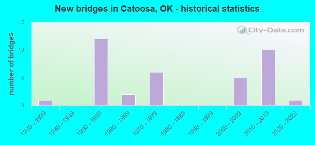
- New bridges - historical statistics
- 11930-1939
- 121950-1959
- 21960-1969
- 61970-1979
- 52000-2009
- 102010-2019
- 12020-2022


- Bridge Condition - Deck
- 10.0%Very good
- 55.0%Good
- 15.0%Satisfactory
- 20.0%Fair

- Bridge Condition - Superstructure
- 45.0%Very good
- 15.0%Good
- 20.0%Satisfactory
- 15.0%Fair
- 5.0%Poor

- Bridge Condition - Substructure
- 15.0%Very good
- 40.0%Good
- 25.0%Satisfactory
- 15.0%Fair
- 5.0%Poor

- Bridge Condition - Channel
- 25.0%Very good
- 54.2%Good
- 20.8%Satisfactory

- Bridge Condition - Culverts
- 10.0%Very good
- 40.0%Good
- 30.0%Satisfactory
- 10.0%Poor
- 10.0%Serious
Find on map >> Show street view
Structure Number: 7136, Location: 0.1 MI S OF PINE ST (Lat: 36.175631, Lng: -95.753319), Route carried "on" structure: County highway 8545, Year Built: 1939, Status: Posted for load, Structure Length: 1.37m (4.49ft), Average Daily Traffic: 4,500 (year 2020), Truck Traffic: 5%, Average Future Daily Traffic: 7,200 (year 2040), Design Load: HS 20, Features Intersected: CREEK
Minimum Vertical Clearance: 30+ m (98+ ft), Kilometerpoint: 1.287, Lanes on structure: 2, Owner: County Highway Agency, Approaching Roadway Width: 6.7m (22.0ft), Material/Design: Concrete, Design/Construction: Slab, Number Of Spans In Main Unit: 2, Length of Maximum Span: 6.1m (20.0ft), Curb-To-Curb Width: 7.3m (24.0ft), Out-to-Out Width: 8.4m (27.6ft)
Condition: Deck: Fair, Superstructure: Satisfactory, Substructure: Poor, Channel: Good, Operating Rating: 35.9 metric tons, Method Used To Determine Operating Rating: Load Factor (LF), Inventory Rating: 21.5 metric tons, Method Used To Determine Inventory Rating: Load Factor (LF), Structural Evaluation: Meets minimum limits, Deck Geometry: High priority of replacement, Waterway Adequacy: Equal to present minimum criteria, Approach Roadway Alignment: Better than present minimum criteria, Bridge Posting: Required (Relationship of Operating Rating to Maximum Legal Load: 0.1 - 9.9% below), Length Of Structure Improvement: 3.93m (12.89ft), Designated Inspection Frequency: Every 24 months, Inspection Date: July 2021, Bridge Improvement Cost: $201,000, Roadway Improvement Cost: $110,000, Total Project Cost: $319,000 ( Estimate for 2015), Deck Structure Type: Concrete Cast-file-Place, Wearing Surface/Protective System: Wearing Surface: Bituminous
Find on map >> Show street view
Structure Number: 13688, Location: 3.3 MI N JCT I-44 (Lat: 36.208106, Lng: -95.724922), Route carried "on" structure: State highway 66, Year Built: 1956, Year Reconstructed: 1979, Status: Open, Structure Length: 25.14m (82.48ft), Average Daily Traffic: 6,750 (year 2020), Truck Traffic: 7%, Average Future Daily Traffic: 10,800 (year 2040), Design Load: H 20, Features Intersected: BIRD CREEK & RD. UNDER
Minimum Vertical Clearance: 4.80m (15.75ft), Kilometerpoint: 5.921, Lanes on structure: 2, Lanes under structure: 2, Owner: State Highway Agency, Approaching Roadway Width: 11.3m (37.1ft), Material/Design: Steel, Design/Construction: Truss - Thru, Number Of Spans In Main Unit: 6, Length of Maximum Span: 64.0m (210.0ft), Curb or Sidewalk Widths: Left: 0.2m (0.7ft), Right: 0.2m (0.7ft), Curb-To-Curb Width: 9.1m (29.9ft), Out-to-Out Width: 9.4m (30.8ft)
Condition: Deck: Fair, Superstructure: Poor, Substructure: Satisfactory, Channel: Satisfactory, Operating Rating: 43.1 metric tons, Method Used To Determine Operating Rating: Load Factor (LF), Inventory Rating: 25.9 metric tons, Method Used To Determine Inventory Rating: Load Factor (LF), Structural Evaluation: Meets minimum limits, Deck Geometry: Meets minimum limits, Underclear: Equal to present minimum criteria, Waterway Adequacy: Better than present minimum criteria, Approach Roadway Alignment: Equal to present desirable criteria, Length Of Structure Improvement: 25.15m (82.51ft), Designated Inspection Frequency: Every 24 months, Critical Feature Inspection Frequency: Every 24 months, Other Special Inspection Frequency: Every 24 months, Inspection Date: November 2021, Critical Feature Inspection Date: November 2021, Other Special Inspection Date: November 2020, Bridge Improvement Cost: $3,226,000, Roadway Improvement Cost: $4,500,000, Total Project Cost: $8,164,000 ( Estimate for 2015), Deck Structure Type: Concrete Cast-file-Place, Wearing Surface/Protective System: Wearing Surface: Monolithic Concrete
Find on map >> Show street view
Structure Number: 13708, Location: 0.7 MI N I-44 (Lat: 36.175461, Lng: -95.750861), Route carried "on" structure: State highway 66, Year Built: 1957, Status: Open, Structure Length: 0.70m (2.30ft), Average Daily Traffic: 18,900 (year 2020), Truck Traffic: 7%, Average Future Daily Traffic: 30,240 (year 2040), Design Load: HS 20, Features Intersected: CREEK
Minimum Vertical Clearance: 30+ m (98+ ft), Kilometerpoint: 1.625, Lanes on structure: 4, Base Highway Network: Yes, Owner: State Highway Agency, Approaching Roadway Width: 10.4m (34.1ft), Skew: 20 degrees, Material/Design: Concrete, Design/Construction: Culvert, Number Of Spans In Main Unit: 2, Length of Maximum Span: 3.0m (9.8ft)
Condition: Channel: Satisfactory, Culverts: Good, Operating Rating: 90.7 metric tons, Method Used To Determine Operating Rating: Load Factor (LF), Inventory Rating: 65.6 metric tons, Method Used To Determine Inventory Rating: Load Factor (LF), Structural Evaluation: Better than present minimum criteria, Waterway Adequacy: Better than present minimum criteria, Approach Roadway Alignment: Equal to present desirable criteria, Length Of Structure Improvement: 0.70m (2.30ft), Designated Inspection Frequency: Every 24 months, Inspection Date: May 2020, Bridge Improvement Cost: $241,000, Roadway Improvement Cost: $397,000, Total Project Cost: $674,000 ( Estimate for 2015)
Find on map >> Show street view
Structure Number: 13746, Location: .4 MI E TULSA-ROGERS (Lat: 36.164147, Lng: -95.754006), Route carried "on" structure: Interstate 44, Year Built: 1957, Status: Open, Structure Length: 1.10m (3.61ft), Average Daily Traffic: 22,350 (year 2020), Truck Traffic: 12%, Average Future Daily Traffic: 35,760 (year 2040), Design Load: HS 20, Features Intersected: CREEK
Minimum Vertical Clearance: 30+ m (98+ ft), Kilometerpoint: 5.744, Lanes on structure: 3, Base Highway Network: Yes, Owner: State Highway Agency, Approaching Roadway Width: 11.6m (38.1ft), Skew: 4 degrees, Material/Design: Concrete, Design/Construction: Culvert, Number Of Spans In Main Unit: 2, Length of Maximum Span: 3.0m (9.8ft)
Condition: Channel: Good, Culverts: Satisfactory, Operating Rating: 44.5 metric tons, Method Used To Determine Operating Rating: Load Factor (LF), Inventory Rating: 32.7 metric tons, Method Used To Determine Inventory Rating: Load Factor (LF), Structural Evaluation: Equal to present minimum criteria, Waterway Adequacy: Equal to present minimum criteria, Approach Roadway Alignment: Better than present minimum criteria, Length Of Structure Improvement: 1.10m (3.61ft), Designated Inspection Frequency: Every 24 months, Inspection Date: April 2020, Bridge Improvement Cost: $284,000, Roadway Improvement Cost: $468,000, Total Project Cost: $795,000 ( Estimate for 2015)
Find on map >> Show street view
Structure Number: 13748, Location: 0.7 MI E TULSA-ROGERS (Lat: 36.165322, Lng: -95.750619), Route carried "on" structure: State highway 66, Year Built: 1957, Status: Open, Structure Length: 1.07m (3.51ft), Average Daily Traffic: 10,000 (year 2020), Truck Traffic: 12%, Average Future Daily Traffic: 16,000 (year 2040), Design Load: HS 20, Features Intersected: CREEK
Minimum Vertical Clearance: 30+ m (98+ ft), Kilometerpoint: 0.386, Lanes on structure: 2, Base Highway Network: Yes, Owner: State Highway Agency, Approaching Roadway Width: 11.6m (38.1ft), Material/Design: Concrete, Design/Construction: Culvert, Number Of Spans In Main Unit: 3, Length of Maximum Span: 3.0m (9.8ft)
Condition: Channel: Satisfactory, Culverts: Serious, Operating Rating: 90.7 metric tons, Method Used To Determine Operating Rating: Load Factor (LF), Inventory Rating: 90.7 metric tons, Method Used To Determine Inventory Rating: Load Factor (LF), Structural Evaluation: High priority of corrective action, Waterway Adequacy: Equal to present minimum criteria, Approach Roadway Alignment: Equal to present desirable criteria, Length Of Structure Improvement: 1.07m (3.51ft), Designated Inspection Frequency: Every 24 months, Inspection Date: May 2020, Bridge Improvement Cost: $469,000, Roadway Improvement Cost: $774,000, Total Project Cost: $1,314,000 ( Estimate for 2015)
Find on map >> Show street view
Structure Number: 13749, Location: 0.7 MI E TULSA-ROGERS (Lat: 36.165706, Lng: -95.752583), Route carried "on" structure: State highway 66, Year Built: 1957, Status: Open, Structure Length: 1.07m (3.51ft), Average Daily Traffic: 11,300 (year 2020), Truck Traffic: 12%, Average Future Daily Traffic: 18,080 (year 2040), Design Load: HS 20, Features Intersected: CREEK
Minimum Vertical Clearance: 30+ m (98+ ft), Kilometerpoint: 0.386, Lanes on structure: 1, Base Highway Network: Yes, Owner: State Highway Agency, Approaching Roadway Width: 10.4m (34.1ft), Material/Design: Concrete, Design/Construction: Culvert, Number Of Spans In Main Unit: 3, Length of Maximum Span: 3.0m (9.8ft)
Condition: Channel: Good, Culverts: Satisfactory, Operating Rating: 44.5 metric tons, Method Used To Determine Operating Rating: Allowable Stress (AS), Inventory Rating: 32.7 metric tons, Method Used To Determine Inventory Rating: Allowable Stress (AS), Structural Evaluation: Equal to present minimum criteria, Waterway Adequacy: Equal to present minimum criteria, Approach Roadway Alignment: Equal to present desirable criteria, Length Of Structure Improvement: 1.07m (3.51ft), Designated Inspection Frequency: Every 24 months, Inspection Date: May 2020, Bridge Improvement Cost: $505,000, Roadway Improvement Cost: $833,000, Total Project Cost: $1,413,000 ( Estimate for 2015)
Find on map >> Show street view
Structure Number: 13825, Location: .6 MI E TULSA-ROGERS (Lat: 36.163908, Lng: -95.752103), Route carried "on" structure: Interstate 44, Year Built: 1957, Status: Open, Structure Length: 4.02m (13.19ft), Average Daily Traffic: 44,400 (year 2020), Truck Traffic: 12%, Average Future Daily Traffic: 71,040 (year 2040), Design Load: HS 20, Features Intersected: S.H. 66 EB UNDER
Minimum Vertical Clearance: 30+ m (98+ ft), Kilometerpoint: 5.792, Lanes on structure: 2, Lanes under structure: 2, Base Highway Network: Yes, Owner: State Highway Agency, Approaching Roadway Width: 12.2m (40.0ft), Skew: 2 degrees, Material/Design: Concrete continuous, Design/Construction: Slab, Number Of Spans In Main Unit: 3, Length of Maximum Span: 15.8m (51.8ft), Curb-To-Curb Width: 9.1m (29.9ft), Out-to-Out Width: 10.7m (35.1ft)
Condition: Deck: Good, Superstructure: Good, Substructure: Satisfactory, Operating Rating: 54.9 metric tons, Method Used To Determine Operating Rating: Load Factor (LF), Inventory Rating: 32.8 metric tons, Method Used To Determine Inventory Rating: Load Factor (LF), Structural Evaluation: Equal to present minimum criteria, Deck Geometry: High priority of replacement, Underclear: Better than present minimum criteria, Approach Roadway Alignment: Better than present minimum criteria, Length Of Structure Improvement: 4.80m (15.75ft), Designated Inspection Frequency: Every 24 months, Inspection Date: April 2020, Bridge Improvement Cost: $616,000, Roadway Improvement Cost: $1,017,000, Total Project Cost: $1,725,000 ( Estimate for 2015), Deck Structure Type: Concrete Cast-file-Place, Wearing Surface/Protective System: Wearing Surface: Low Slump Concrete
Find on map >> Show street view
Structure Number: 13883, Location: 0.8 MI E TULSA-ROGERS (Lat: 36.167442, Lng: -95.750869), Route carried "on" structure: State highway 66, Year Built: 1957, Status: Open, Structure Length: 5.24m (17.19ft), Average Daily Traffic: 10,000 (year 2020), Truck Traffic: 15%, Average Future Daily Traffic: 16,000 (year 2040), Design Load: HS 20, Features Intersected: ABANDONED TPK UNDER
Minimum Vertical Clearance: 30+ m (98+ ft), Kilometerpoint: 0.563, Lanes on structure: 2, Base Highway Network: Yes, Owner: State Highway Agency, Approaching Roadway Width: 11.6m (38.1ft), Skew: 4 degrees, Material/Design: Concrete continuous, Design/Construction: Slab, Number Of Spans In Main Unit: 3, Length of Maximum Span: 20.7m (67.9ft), Curb-To-Curb Width: 8.5m (27.9ft), Out-to-Out Width: 10.1m (33.1ft)
Condition: Deck: Good, Superstructure: Satisfactory, Substructure: Satisfactory, Operating Rating: 62.1 metric tons, Method Used To Determine Operating Rating: Load Factor (LF), Inventory Rating: 37.2 metric tons, Method Used To Determine Inventory Rating: Load Factor (LF), Structural Evaluation: Equal to present minimum criteria, Deck Geometry: High priority of corrective action, Approach Roadway Alignment: Better than present minimum criteria, Length Of Structure Improvement: 8.15m (26.74ft), Designated Inspection Frequency: Every 24 months, Inspection Date: May 2020, Bridge Improvement Cost: $671,000, Roadway Improvement Cost: $1,108,000, Total Project Cost: $1,880,000 ( Estimate for 2015), Deck Structure Type: Concrete Cast-file-Place, Wearing Surface/Protective System: Wearing Surface: Low Slump Concrete
Find on map >> Show street view
Structure Number: 13978, Location: 3.3MI NE OF T.P.GATE (Lat: 36.195842, Lng: -95.716711), Route carried "on" structure: Interstate 44, Year Built: 1958, Status: Open, Structure Length: 0.64m (2.10ft), Average Daily Traffic: 26,200 (year 2020), Truck Traffic: 36%, Average Future Daily Traffic: 41,920 (year 2040), Design Load: HS 20, Features Intersected: CREEK
Minimum Vertical Clearance: 30+ m (98+ ft), Kilometerpoint: 4.344, Lanes on structure: 4, Base Highway Network: Yes, Toll: On toll road, Owner: State Toll Authority, Approaching Roadway Width: 24.7m (81.0ft), Skew: 30 degrees, Material/Design: Concrete, Design/Construction: Culvert, Number Of Spans In Main Unit: 2, Length of Maximum Span: 3.0m (9.8ft), Curb-To-Curb Width: 55.2m (181.1ft), Out-to-Out Width: 55.8m (183.1ft)
Condition: Channel: Good, Culverts: Satisfactory, Operating Rating: 44.5 metric tons, Method Used To Determine Operating Rating: Load Factor (LF), Inventory Rating: 32.7 metric tons, Method Used To Determine Inventory Rating: Load Factor (LF), Structural Evaluation: Equal to present minimum criteria, Deck Geometry: Superior to present desirable criteria, Waterway Adequacy: Superior to present desirable criteria, Approach Roadway Alignment: Equal to present desirable criteria, Length Of Structure Improvement: 2.72m (8.92ft), Designated Inspection Frequency: Every 24 months, Inspection Date: August 2021, Bridge Improvement Cost: $200,000, Roadway Improvement Cost: $150,000, Total Project Cost: $360,000 ( Estimate for 2015)
Find on map >> Show street view
Structure Number: 14176, Location: 2.35MI NEOF TP GATE (Lat: 36.187778, Lng: -95.726389), Route carried "on" structure: County highway N4090, Year Built: 1958, Status: Open, Structure Length: 7.07m (23.20ft), Average Daily Traffic: 5,000 (year 2020), Truck Traffic: 15%, Average Future Daily Traffic: 8,000 (year 2040), Design Load: H 20, Features Intersected: WILL ROGERS TP I-44 UND
Minimum Vertical Clearance: 30+ m (98+ ft), Kilometerpoint: 4.505, Lanes on structure: 2, Lanes under structure: 4, Owner: State Toll Authority, Approaching Roadway Width: 7.3m (24.0ft), Skew: 4 degrees, Material/Design: Steel, Design/Construction: Stringer/Multi-beam, Number Of Spans In Main Unit: 4, Length of Maximum Span: 18.6m (61.0ft), Curb or Sidewalk Widths: Left: 0.9m (3.0ft), Right: 0.9m (3.0ft), Curb-To-Curb Width: 7.3m (24.0ft), Out-to-Out Width: 9.1m (29.9ft)
Condition: Deck: Satisfactory, Superstructure: Satisfactory, Substructure: Good, Operating Rating: 53.2 metric tons, Method Used To Determine Operating Rating: Load Factor (LF), Inventory Rating: 31.8 metric tons, Method Used To Determine Inventory Rating: Load Factor (LF), Structural Evaluation: Equal to present minimum criteria, Deck Geometry: High priority of replacement, Underclear: High priority of replacement, Approach Roadway Alignment: Somewhat better than minimum adequacy, Length Of Structure Improvement: 7.07m (23.20ft), Designated Inspection Frequency: Every 24 months, Inspection Date: August 2021, Bridge Improvement Cost: $883,000, Roadway Improvement Cost: $1,250,000, Total Project Cost: $2,437,000 ( Estimate for 2015), Deck Structure Type: Concrete Cast-file-Place, Wearing Surface/Protective System: Wearing Surface: Monolithic Concrete
Find on map >> Show street view
Structure Number: 17603, Location: 3.8 MI N JCT I 44 (Lat: 36.214492, Lng: -95.721328), Route carried "on" structure: State highway 66, Year Built: 1969, Status: Open, Structure Length: 25.85m (84.81ft), Average Daily Traffic: 7,500 (year 2020), Truck Traffic: 15%, Average Future Daily Traffic: 12,000 (year 2040), Design Load: HS 20, Features Intersected: VERDIGRIS RIVER (KMARNS)
Minimum Vertical Clearance: 30+ m (98+ ft), Kilometerpoint: 6.709, Lanes on structure: 2, Owner: State Highway Agency, Approaching Roadway Width: 11.6m (38.1ft), Skew: 10 degrees, Navigation Control: Yes ( Vertical Clearance: 15.8m (51.8ft), Horizontal Clearance: 91.4m (299.9ft)), Material/Design: Steel continuous, Design/Construction: Girder and Floorbeam System, Number Of Spans In Main Unit: 3, Number Of Approach Spans: 2, Length of Maximum Span: 101.8m (334.0ft), Curb or Sidewalk Widths: Left: 0.3m (1.0ft), Right: 0.3m (1.0ft), Curb-To-Curb Width: 8.5m (27.9ft), Out-to-Out Width: 9.4m (30.8ft)
Condition: Deck: Fair, Superstructure: Fair, Substructure: Fair, Channel: Good, Operating Rating: 55.9 metric tons, Method Used To Determine Operating Rating: Load Factor (LF), Inventory Rating: 33.6 metric tons, Method Used To Determine Inventory Rating: Load Factor (LF), Structural Evaluation: Somewhat better than minimum adequacy, Deck Geometry: High priority of corrective action, Waterway Adequacy: Better than present minimum criteria, Approach Roadway Alignment: Equal to present minimum criteria, Length Of Structure Improvement: 25.85m (84.81ft), Designated Inspection Frequency: Every 24 months, Inspection Date: May 2021, Bridge Improvement Cost: $5,071,000, Roadway Improvement Cost: $4,500,000, Total Project Cost: $10,113,000 ( Estimate for 2015), Deck Structure Type: Concrete Cast-file-Place, Wearing Surface/Protective System: Wearing Surface: Monolithic Concrete
Find on map >> Show street view
Structure Number: 17604, Location: 3.8 MI N JCT I 44 (Lat: 36.214675, Lng: -95.721544), Route carried "on" structure: State highway 66, Year Built: 1969, Status: Open, Structure Length: 25.85m (84.81ft), Average Daily Traffic: 8,600 (year 2020), Truck Traffic: 15%, Average Future Daily Traffic: 13,760 (year 2040), Design Load: HS 20, Features Intersected: VERDIGRIS RIVER (KMARNS)
Minimum Vertical Clearance: 30+ m (98+ ft), Kilometerpoint: 6.709, Lanes on structure: 2, Owner: State Highway Agency, Approaching Roadway Width: 10.4m (34.1ft), Skew: 10 degrees, Navigation Control: Yes ( Vertical Clearance: 15.8m (51.8ft), Horizontal Clearance: 91.4m (299.9ft)), Material/Design: Steel continuous, Design/Construction: Girder and Floorbeam System, Number Of Spans In Main Unit: 3, Number Of Approach Spans: 2, Length of Maximum Span: 101.8m (334.0ft), Curb or Sidewalk Widths: Left: 0.3m (1.0ft), Right: 0.3m (1.0ft), Curb-To-Curb Width: 8.5m (27.9ft), Out-to-Out Width: 9.4m (30.8ft)
Condition: Deck: Fair, Superstructure: Fair, Substructure: Fair, Channel: Good, Operating Rating: 55.9 metric tons, Method Used To Determine Operating Rating: Load Factor (LF), Inventory Rating: 33.6 metric tons, Method Used To Determine Inventory Rating: Load Factor (LF), Structural Evaluation: Somewhat better than minimum adequacy, Deck Geometry: High priority of corrective action, Waterway Adequacy: Better than present minimum criteria, Approach Roadway Alignment: Equal to present minimum criteria, Length Of Structure Improvement: 25.85m (84.81ft), Designated Inspection Frequency: Every 24 months, Inspection Date: May 2021, Bridge Improvement Cost: $5,071,000, Roadway Improvement Cost: $4,500,000, Total Project Cost: $10,113,000 ( Estimate for 2015), Deck Structure Type: Concrete Cast-file-Place, Wearing Surface/Protective System: Wearing Surface: Monolithic Concrete
Find on map >> Show street view
Structure Number: 1814, Location: 5.6 MI E TULSA C/L (Lat: 36.249461, Lng: -95.734908), Route carried "on" structure: State highway 266, Year Built: 1971, Status: Open, Structure Length: 15.91m (52.20ft), Average Daily Traffic: 8,900 (year 2020), Truck Traffic: 15%, Average Future Daily Traffic: 14,240 (year 2040), Design Load: HS 20, Features Intersected: VERDIGRIS RIVER
Minimum Vertical Clearance: 30+ m (98+ ft), Kilometerpoint: 8.431, Lanes on structure: 2, Owner: State Highway Agency, Approaching Roadway Width: 15.5m (50.9ft), Material/Design: Steel continuous, Design/Construction: Stringer/Multi-beam, Number Of Spans In Main Unit: 3, Length of Maximum Span: 61.0m (200.1ft), Curb-To-Curb Width: 14.6m (47.9ft), Out-to-Out Width: 15.2m (49.9ft)
Condition: Deck: Satisfactory, Superstructure: Fair, Substructure: Satisfactory, Channel: Good, Operating Rating: 55.8 metric tons, Method Used To Determine Operating Rating: Load Factor (LF), Inventory Rating: 33.4 metric tons, Method Used To Determine Inventory Rating: Load Factor (LF), Structural Evaluation: Somewhat better than minimum adequacy, Deck Geometry: Superior to present desirable criteria, Waterway Adequacy: Equal to present desirable criteria, Approach Roadway Alignment: Equal to present desirable criteria, Length Of Structure Improvement: 15.91m (52.20ft), Designated Inspection Frequency: Every 24 months, Inspection Date: June 2021, Bridge Improvement Cost: $2,072,000, Roadway Improvement Cost: $3,419,000, Total Project Cost: $5,802,000 ( Estimate for 2015), Deck Structure Type: Concrete Cast-file-Place, Wearing Surface/Protective System: Wearing Surface: Monolithic Concrete
Find on map >> Show street view
Structure Number: 18768, Location: 1.3 MI N JCT I-44 (Lat: 36.182028, Lng: -95.759747), Route carried "on" structure: State highway 167, Year Built: 1974, Status: Open, Structure Length: 7.09m (23.26ft), Average Daily Traffic: 8,300 (year 2020), Truck Traffic: 5%, Average Future Daily Traffic: 13,280 (year 2040), Design Load: HS 20, Features Intersected: BNSF R.R. & CO RD UNDER
Minimum Vertical Clearance: 30+ m (98+ ft), Kilometerpoint: 2.189, Lanes on structure: 2, Lanes under structure: 2, Base Highway Network: Yes, Owner: State Highway Agency, Approaching Roadway Width: 14.0m (45.9ft), Material/Design: Prestressed concrete, Design/Construction: Stringer/Multi-beam, Number Of Spans In Main Unit: 4, Length of Maximum Span: 20.1m (65.9ft), Curb-To-Curb Width: 14.0m (45.9ft), Out-to-Out Width: 15.2m (49.9ft)
Condition: Deck: Good, Superstructure: Good, Substructure: Good, Operating Rating: 44.9 metric tons, Method Used To Determine Operating Rating: Load and Resistance Factor (LRFR), Inventory Rating: 22.4 metric tons, Method Used To Determine Inventory Rating: Load and Resistance Factor (LRFR), Structural Evaluation: Somewhat better than minimum adequacy, Deck Geometry: Superior to present desirable criteria, Underclear: Superior to present desirable criteria, Approach Roadway Alignment: Equal to present desirable criteria, Length Of Structure Improvement: 7.88m (25.85ft), Designated Inspection Frequency: Every 24 months, Inspection Date: May 2020, Bridge Improvement Cost: $1,920,000, Roadway Improvement Cost: $3,167,000, Total Project Cost: $5,375,000 ( Estimate for 2015), Deck Structure Type: Concrete Cast-file-Place, Wearing Surface/Protective System: Wearing Surface: Monolithic Concrete, Membrane: Epoxy, Deck Protection: Epoxy Coated Reinforcing
Find on map >> Show street view
Structure Number: 18782, Location: 2.8 MI N JCT I-44 (Lat: 36.206394, Lng: -95.758661), Route carried "on" structure: State highway 167, Year Built: 1974, Status: Open, Structure Length: 13.78m (45.21ft), Average Daily Traffic: 8,200 (year 2020), Truck Traffic: 5%, Average Future Daily Traffic: 13,120 (year 2040), Design Load: HS 20, Features Intersected: BIRD CREEK O'FLOW
Minimum Vertical Clearance: 30+ m (98+ ft), Kilometerpoint: 4.780, Lanes on structure: 2, Base Highway Network: Yes, Owner: State Highway Agency, Approaching Roadway Width: 13.4m (44.0ft), Material/Design: Prestressed concrete, Design/Construction: Stringer/Multi-beam, Number Of Spans In Main Unit: 9, Length of Maximum Span: 15.2m (49.9ft), Curb-To-Curb Width: 14.2m (46.6ft), Out-to-Out Width: 15.0m (49.2ft)
Condition: Deck: Satisfactory, Superstructure: Good, Substructure: Good, Channel: Very good, Operating Rating: 46.7 metric tons, Method Used To Determine Operating Rating: Load and Resistance Factor (LRFR), Inventory Rating: 36.0 metric tons, Method Used To Determine Inventory Rating: Load and Resistance Factor (LRFR), Structural Evaluation: Better than present minimum criteria, Deck Geometry: Superior to present desirable criteria, Waterway Adequacy: Better than present minimum criteria, Approach Roadway Alignment: Equal to present desirable criteria, Length Of Structure Improvement: 13.86m (45.47ft), Designated Inspection Frequency: Every 24 months, Inspection Date: May 2020, Bridge Improvement Cost: $3,378,000, Roadway Improvement Cost: $4,500,000, Total Project Cost: $8,324,000 ( Estimate for 2015), Deck Structure Type: Concrete Cast-file-Place, Wearing Surface/Protective System: Wearing Surface: Monolithic Concrete
Find on map >> Show street view
Structure Number: 18787, Location: 2.7 MI JCT I-44 (Lat: 36.204172, Lng: -95.758544), Route carried "on" structure: State highway 167, Year Built: 1974, Status: Open, Structure Length: 15.30m (50.20ft), Average Daily Traffic: 8,200 (year 2020), Truck Traffic: 5%, Average Future Daily Traffic: 13,120 (year 2040), Design Load: HS 20, Features Intersected: BIRD CREEK
Minimum Vertical Clearance: 30+ m (98+ ft), Kilometerpoint: 4.521, Lanes on structure: 2, Base Highway Network: Yes, Owner: State Highway Agency, Approaching Roadway Width: 13.4m (44.0ft), Material/Design: Prestressed concrete, Design/Construction: Stringer/Multi-beam, Number Of Spans In Main Unit: 4, Number Of Approach Spans: 3, Length of Maximum Span: 30.5m (100.1ft), Curb-To-Curb Width: 14.6m (47.9ft), Out-to-Out Width: 15.2m (49.9ft)
Condition: Deck: Good, Superstructure: Satisfactory, Substructure: Satisfactory, Channel: Satisfactory, Operating Rating: 62.6 metric tons, Method Used To Determine Operating Rating: Load Factor (LF), Inventory Rating: 32.3 metric tons, Method Used To Determine Inventory Rating: Load Factor (LF), Structural Evaluation: Equal to present minimum criteria, Deck Geometry: Superior to present desirable criteria, Waterway Adequacy: Equal to present minimum criteria, Approach Roadway Alignment: Equal to present desirable criteria, Length Of Structure Improvement: 15.30m (50.20ft), Designated Inspection Frequency: Every 24 months, Inspection Date: June 2021, Bridge Improvement Cost: $3,729,000, Roadway Improvement Cost: $4,500,000, Total Project Cost: $8,695,000 ( Estimate for 2015), Deck Structure Type: Concrete Cast-file-Place, Wearing Surface/Protective System: Wearing Surface: Monolithic Concrete, Deck Protection: Epoxy Coated Reinforcing
Find on map >> Show street view
Structure Number: 1921, Location: 0.2 MI W OF TURNPIKE (Lat: 36.177025, Lng: -95.742775), Route carried "on" structure: County highway E0580, Year Built: 1976, Status: Open, Structure Length: 3.11m (10.20ft), Average Daily Traffic: 500 (year 2020), Truck Traffic: 5%, Average Future Daily Traffic: 800 (year 2040), Design Load: HS 20, Features Intersected: SPUNKY CREEK
Minimum Vertical Clearance: 30+ m (98+ ft), Kilometerpoint: 0.483, Lanes on structure: 2, Owner: County Highway Agency, Approaching Roadway Width: 7.3m (24.0ft), Skew: 1 degrees, Material/Design: Prestressed concrete, Design/Construction: Stringer/Multi-beam, Number Of Spans In Main Unit: 1, Length of Maximum Span: 3.0m (9.8ft), Curb-To-Curb Width: 9.8m (32.2ft), Out-to-Out Width: 10.8m (35.4ft)
Condition: Deck: Good, Superstructure: Very good, Substructure: Fair, Channel: Good, Operating Rating: 67.5 metric tons, Method Used To Determine Operating Rating: Load Factor (LF), Inventory Rating: 25.4 metric tons, Method Used To Determine Inventory Rating: Load Factor (LF), Structural Evaluation: Somewhat better than minimum adequacy, Deck Geometry: Equal to present minimum criteria, Waterway Adequacy: Equal to present desirable criteria, Approach Roadway Alignment: Equal to present minimum criteria, Length Of Structure Improvement: 6.30m (20.67ft), Designated Inspection Frequency: Every 24 months, Inspection Date: July 2021, Bridge Improvement Cost: $321,000, Roadway Improvement Cost: $177,000, Total Project Cost: $513,000 ( Estimate for 2015), Deck Structure Type: Concrete Cast-file-Place, Wearing Surface/Protective System: Wearing Surface: Bituminous
Find on map >> Show street view
Structure Number: 2563, Location: 1.7 MI N JCT I 44 (Lat: 36.187714, Lng: -95.739806), Route carried "on" structure: State highway 66, Year Built: 2000, Status: Open, Structure Length: 5.21m (17.09ft), Average Daily Traffic: 7,500 (year 2020), Truck Traffic: 7%, Average Future Daily Traffic: 12,000 (year 2040), Design Load: HS 20, Features Intersected: SPUNKY CREEK
Minimum Vertical Clearance: 30+ m (98+ ft), Kilometerpoint: 3.235, Lanes on structure: 2, Base Highway Network: Yes, Owner: State Highway Agency, Approaching Roadway Width: 11.0m (36.1ft), Skew: 10 degrees, Material/Design: Prestressed concrete, Design/Construction: Stringer/Multi-beam, Number Of Spans In Main Unit: 3, Length of Maximum Span: 23.8m (78.1ft), Curb-To-Curb Width: 11.0m (36.1ft), Out-to-Out Width: 11.6m (38.1ft)
Condition: Deck: Good, Superstructure: Very good, Substructure: Good, Channel: Very good, Operating Rating: 86.7 metric tons, Method Used To Determine Operating Rating: Load Factor (LF), Inventory Rating: 43.7 metric tons, Method Used To Determine Inventory Rating: Load Factor (LF), Structural Evaluation: Better than present minimum criteria, Deck Geometry: Equal to present minimum criteria, Waterway Adequacy: Better than present minimum criteria, Approach Roadway Alignment: Equal to present desirable criteria, Length Of Structure Improvement: 8.28m (27.17ft), Designated Inspection Frequency: Every 24 months, Inspection Date: May 2020, Bridge Improvement Cost: $1,062,000, Roadway Improvement Cost: $1,752,000, Total Project Cost: $2,973,000 ( Estimate for 2015), Deck Structure Type: Concrete Cast-file-Place, Wearing Surface/Protective System: Wearing Surface: Monolithic Concrete, Membrane: Epoxy, Deck Protection: Epoxy Coated Reinforcing
Find on map >> Show street view
Structure Number: 25631, Location: 1.7 MI N JCT I-44 (Lat: 36.187972, Lng: -95.739989), Route carried "on" structure: State highway 66, Year Built: 2000, Status: Open, Structure Length: 5.21m (17.09ft), Average Daily Traffic: 9,300 (year 2020), Truck Traffic: 7%, Average Future Daily Traffic: 14,880 (year 2040), Design Load: HS 20, Features Intersected: SPUNKY CREEK
Minimum Vertical Clearance: 30+ m (98+ ft), Kilometerpoint: 3.235, Lanes on structure: 2, Base Highway Network: Yes, Owner: State Highway Agency, Approaching Roadway Width: 11.0m (36.1ft), Skew: 10 degrees, Material/Design: Prestressed concrete, Design/Construction: Stringer/Multi-beam, Number Of Spans In Main Unit: 3, Length of Maximum Span: 22.9m (75.1ft), Curb-To-Curb Width: 11.0m (36.1ft), Out-to-Out Width: 12.0m (39.4ft)
Condition: Deck: Good, Superstructure: Very good, Substructure: Good, Channel: Very good, Operating Rating: 86.7 metric tons, Method Used To Determine Operating Rating: Load Factor (LF), Inventory Rating: 43.7 metric tons, Method Used To Determine Inventory Rating: Load Factor (LF), Structural Evaluation: Better than present minimum criteria, Deck Geometry: Equal to present minimum criteria, Waterway Adequacy: Better than present minimum criteria, Approach Roadway Alignment: Equal to present desirable criteria, Length Of Structure Improvement: 8.28m (27.17ft), Designated Inspection Frequency: Every 24 months, Inspection Date: May 2020, Bridge Improvement Cost: $1,062,000, Roadway Improvement Cost: $1,752,000, Total Project Cost: $2,973,000 ( Estimate for 2015), Deck Structure Type: Concrete Cast-file-Place, Wearing Surface/Protective System: Wearing Surface: Monolithic Concrete, Membrane: Epoxy, Deck Protection: Epoxy Coated Reinforcing
Find on map >> Show street view
Structure Number: 26524, Location: PINE ST. IN CATOOSA (Lat: 36.176897, Lng: -95.758831), Route carried "on" structure: County highway E0570, Year Built: 2001, Status: Open, Structure Length: 1.33m (4.36ft), Average Daily Traffic: 100 (year 2020), Truck Traffic: 10%, Average Future Daily Traffic: 160 (year 2040), Design Load: HS 20, Features Intersected: CREEK
Minimum Vertical Clearance: 30+ m (98+ ft), Kilometerpoint: 0.161, Lanes on structure: 2, Owner: County Highway Agency, Approaching Roadway Width: 6.4m (21.0ft), Skew: 3 degrees, Material/Design: Concrete, Design/Construction: Culvert, Number Of Spans In Main Unit: 3, Length of Maximum Span: 3.7m (12.1ft), Curb-To-Curb Width: 22.6m (74.1ft), Out-to-Out Width: 23.0m (75.5ft)
Condition: Channel: Good, Culverts: Good, Operating Rating: 58.8 metric tons, Method Used To Determine Operating Rating: Load Factor (LF), Inventory Rating: 35.2 metric tons, Method Used To Determine Inventory Rating: Load Factor (LF), Structural Evaluation: Better than present minimum criteria, Deck Geometry: Superior to present desirable criteria, Waterway Adequacy: Equal to present minimum criteria, Approach Roadway Alignment: Equal to present desirable criteria, Length Of Structure Improvement: 10.39m (34.09ft), Designated Inspection Frequency: Every 24 months, Inspection Date: July 2021, Bridge Improvement Cost: $100,000, Roadway Improvement Cost: $75,000, Total Project Cost: $225,000 ( Estimate for 2015), Deck Structure Type: Concrete Cast-file-Place, Wearing Surface/Protective System: Wearing Surface: Monolithic Concrete
Find on map >> Show street view
Structure Number: 2711, Location: .4E JCT I-44 (Lat: 36.162756, Lng: -95.745500), Route carried "on" structure: Interstate 44, Year Built: 2001, Status: Open, Structure Length: 5.15m (16.90ft), Average Daily Traffic: 22,200 (year 2020), Truck Traffic: 8%, Average Future Daily Traffic: 35,520 (year 2040), Design Load: HS 20, Features Intersected: SPUNKY CREEK
Minimum Vertical Clearance: 30+ m (98+ ft), Kilometerpoint: 6.854, Lanes on structure: 3, Base Highway Network: Yes, Owner: State Highway Agency, Approaching Roadway Width: 17.1m (56.1ft), Skew: 10 degrees, Material/Design: Prestressed concrete, Design/Construction: Stringer/Multi-beam, Number Of Spans In Main Unit: 3, Length of Maximum Span: 22.9m (75.1ft), Curb-To-Curb Width: 17.1m (56.1ft), Out-to-Out Width: 18.0m (59.1ft)
Condition: Deck: Good, Superstructure: Very good, Substructure: Very good, Channel: Very good, Operating Rating: 52.9 metric tons, Method Used To Determine Operating Rating: Load Factor (LF), Inventory Rating: 31.7 metric tons, Method Used To Determine Inventory Rating: Load Factor (LF), Structural Evaluation: Better than present minimum criteria, Deck Geometry: Equal to present minimum criteria, Waterway Adequacy: Equal to present desirable criteria, Approach Roadway Alignment: Equal to present desirable criteria, Length Of Structure Improvement: 8.23m (27.00ft), Designated Inspection Frequency: Every 24 months, Inspection Date: May 2020, Bridge Improvement Cost: $1,477,000, Roadway Improvement Cost: $2,438,000, Total Project Cost: $4,137,000 ( Estimate for 2015), Deck Structure Type: Concrete Cast-file-Place, Wearing Surface/Protective System: Wearing Surface: Monolithic Concrete, Membrane: Epoxy, Deck Protection: Epoxy Coated Reinforcing
Find on map >> Show street view
Structure Number: 28203, Location: TULSA-ROGERS CO.LINE (Lat: 36.162411, Lng: -95.762014), Route carried "on" structure: Interstate 44, Year Built: 2010, Status: Open, Structure Length: 8.69m (28.51ft), Average Daily Traffic: 65,600 (year 2020), Truck Traffic: 12%, Average Future Daily Traffic: 104,960 (year 2040), Design Load: HL 93, Features Intersected: 193RD E. AVE. UNDER
Minimum Vertical Clearance: 30+ m (98+ ft), Kilometerpoint: 4.810, Lanes on structure: 4, Lanes under structure: 8, Base Highway Network: Yes, Owner: State Highway Agency, Approaching Roadway Width: 22.3m (73.2ft), Material/Design: Prestressed concrete, Design/Construction: Stringer/Multi-beam, Number Of Spans In Main Unit: 3, Length of Maximum Span: 40.5m (132.9ft), Curb-To-Curb Width: 49.4m (162.1ft), Out-to-Out Width: 50.3m (165.0ft)
Condition: Deck: Good, Superstructure: Very good, Substructure: Good, Operating Rating: 71.2 metric tons, Method Used To Determine Operating Rating: Load and Resistance Factor (LRFR), Inventory Rating: 46.0 metric tons, Method Used To Determine Inventory Rating: Load and Resistance Factor (LRFR), Structural Evaluation: Better than present minimum criteria, Deck Geometry: Superior to present desirable criteria, Underclear: Meets minimum limits, Approach Roadway Alignment: Equal to present desirable criteria, Designated Inspection Frequency: Every 24 months, Inspection Date: April 2020, Bridge Improvement Cost: $777,000, Roadway Improvement Cost: $1,333,000, Total Project Cost: $2,222,000 ( Estimate for 2015), Deck Structure Type: Concrete Cast-file-Place, Wearing Surface/Protective System: Wearing Surface: Monolithic Concrete, Membrane: Epoxy, Deck Protection: Epoxy Coated Reinforcing
Find on map >> Show street view
Structure Number: 28205, Location: .3 MI.E.TULSA CO.LINE (Lat: 36.161903, Lng: -95.754061), Route carried "on" structure: Interstate 44, Year Built: 2010, Status: Open, Structure Length: 1.04m (3.41ft), Average Daily Traffic: 33,350 (year 2020), Truck Traffic: 12%, Average Future Daily Traffic: 53,360 (year 2040), Design Load: HL 93, Features Intersected: CREEK
Minimum Vertical Clearance: 30+ m (98+ ft), Kilometerpoint: 5.472, Lanes on structure: 1, Base Highway Network: Yes, Owner: State Highway Agency, Approaching Roadway Width: 7.6m (24.9ft), Material/Design: Concrete, Design/Construction: Culvert, Number Of Spans In Main Unit: 3, Length of Maximum Span: 3.0m (9.8ft)
Condition: Channel: Good, Culverts: Very good, Operating Rating: 60.2 metric tons, Method Used To Determine Operating Rating: Load and Resistance Factor (LRFR), Inventory Rating: 46.4 metric tons, Method Used To Determine Inventory Rating: Load and Resistance Factor (LRFR), Structural Evaluation: Equal to present desirable criteria, Waterway Adequacy: Equal to present desirable criteria, Approach Roadway Alignment: Equal to present desirable criteria, Designated Inspection Frequency: Every 24 months, Inspection Date: April 2020, Bridge Improvement Cost: $230,000, Roadway Improvement Cost: $380,000, Total Project Cost: $644,000 ( Estimate for 2015)
Find on map >> Show street view
Structure Number: 28343, Location: .3 MI.E.TULSA-ROGERS C/L (Lat: 36.162536, Lng: -95.753911), Route carried "on" structure: Interstate 44, Year Built: 2010, Status: Open, Structure Length: 1.04m (3.41ft), Average Daily Traffic: 22,200 (year 2020), Truck Traffic: 12%, Average Future Daily Traffic: 35,520 (year 2040), Design Load: HL 93, Features Intersected: CREEK
Minimum Vertical Clearance: 30+ m (98+ ft), Kilometerpoint: 5.744, Lanes on structure: 3, Base Highway Network: Yes, Owner: State Highway Agency, Approaching Roadway Width: 12.2m (40.0ft), Material/Design: Concrete, Design/Construction: Culvert, Number Of Spans In Main Unit: 3, Length of Maximum Span: 3.0m (9.8ft)
Condition: Channel: Good, Culverts: Good, Operating Rating: 60.2 metric tons, Method Used To Determine Operating Rating: Load and Resistance Factor (LRFR), Inventory Rating: 46.4 metric tons, Method Used To Determine Inventory Rating: Load and Resistance Factor (LRFR), Structural Evaluation: Better than present minimum criteria, Waterway Adequacy: Equal to present desirable criteria, Approach Roadway Alignment: Equal to present desirable criteria, Length Of Structure Improvement: 1.01m (3.31ft), Designated Inspection Frequency: Every 24 months, Inspection Date: April 2020, Bridge Improvement Cost: $230,000, Roadway Improvement Cost: $380,000, Total Project Cost: $644,000 ( Estimate for 2015)
Find on map >> Show street view
Structure Number: 28826, Location: .5 S OF PINE STREET (Lat: 36.166186, Lng: -95.806481), Route carried "on" structure: County highway N4050, Year Built: 2007, Status: Posted for load, Structure Length: 0.98m (3.22ft), Average Daily Traffic: 100 (year 2020), Truck Traffic: 5%, Average Future Daily Traffic: 160 (year 2040), Design Load: HS 20, Features Intersected: CREEK, Facility Carried by Structure: N. 153RD E. AVE.
Minimum Vertical Clearance: 30+ m (98+ ft), Kilometerpoint: 0.008, Lanes on structure: 2, Owner: County Highway Agency, Approaching Roadway Width: 5.8m (19.0ft), Skew: 3 degrees, Material/Design: Steel, Design/Construction: Culvert, Number Of Spans In Main Unit: 6, Length of Maximum Span: 0.9m (3.0ft), Curb-To-Curb Width: 6.7m (22.0ft), Out-to-Out Width: 7.3m (24.0ft)
Condition: Channel: Very good, Culverts: Poor, Operating Rating: 38.4 metric tons, Method Used To Determine Operating Rating: Load Factor (LF), Inventory Rating: 23.0 metric tons, Method Used To Determine Inventory Rating: Load Factor (LF), Structural Evaluation: Meets minimum limits, Deck Geometry: Somewhat better than minimum adequacy, Waterway Adequacy: Better than present minimum criteria, Approach Roadway Alignment: Better than present minimum criteria, Length Of Structure Improvement: 1.07m (3.51ft), Designated Inspection Frequency: Every 24 months, Inspection Date: July 2021, Bridge Improvement Cost: $225,000, Roadway Improvement Cost: $50,000, Total Project Cost: $300,000 ( Estimate for 2015)
Find on map >> Show street view
Structure Number: 29441, Location: 1.8E JCT I-244 (Lat: 36.162322, Lng: -95.794758), Route carried "on" structure: Interstate 44, Year Built: 2010, Status: Open, Structure Length: 5.81m (19.06ft), Average Daily Traffic: 65,600 (year 2020), Truck Traffic: 12%, Average Future Daily Traffic: 104,960 (year 2040), Design Load: HS 20, Features Intersected: 163RD E. AVE. UNDER
Minimum Vertical Clearance: 30+ m (98+ ft), Kilometerpoint: 3.003, Lanes on structure: 4, Lanes under structure: 4, Base Highway Network: Yes, Owner: State Highway Agency, Approaching Roadway Width: 21.9m (71.9ft), Skew: 30 degrees, Material/Design: Steel, Design/Construction: Stringer/Multi-beam, Number Of Spans In Main Unit: 1, Number Of Approach Spans: 2, Length of Maximum Span: 27.4m (89.9ft), Curb-To-Curb Width: 21.9m (71.9ft), Out-to-Out Width: 44.8m (147.0ft)
Condition: Deck: Good, Superstructure: Very good, Substructure: Good, Operating Rating: 43.0 metric tons, Method Used To Determine Operating Rating: Load and Resistance Factor (LRFR), Inventory Rating: 33.1 metric tons, Method Used To Determine Inventory Rating: Load and Resistance Factor (LRFR), Structural Evaluation: Better than present minimum criteria, Deck Geometry: Better than present minimum criteria, Underclear: Equal to present minimum criteria, Approach Roadway Alignment: Equal to present desirable criteria, Length Of Structure Improvement: 6.40m (21.00ft), Designated Inspection Frequency: Every 24 months, Inspection Date: April 2020, Bridge Improvement Cost: $3,900,000, Roadway Improvement Cost: $6,000,000, Total Project Cost: $10,920,000 ( Estimate for 2015), Deck Structure Type: Concrete Cast-file-Place, Wearing Surface/Protective System: Wearing Surface: Monolithic Concrete, Membrane: Epoxy, Deck Protection: Epoxy Coated Reinforcing
Find on map >> Show street view
Structure Number: 297, Location: .1S; 3W OF FAIR OAKS (Lat: 36.160556, Lng: -95.745278), Route carried "on" structure: County highway E0591, Year Built: 2011, Status: Open, Structure Length: 4.88m (16.01ft), Average Daily Traffic: 650 (year 2020), Truck Traffic: 10%, Average Future Daily Traffic: 845 (year 2040), Design Load: HS 20, Features Intersected: SPUNKY CREEK
Minimum Vertical Clearance: 30+ m (98+ ft), Kilometerpoint: 0.000, Lanes on structure: 2, Owner: County Highway Agency, Approaching Roadway Width: 6.7m (22.0ft), Material/Design: Steel, Design/Construction: Stringer/Multi-beam, Number Of Spans In Main Unit: 3, Length of Maximum Span: 21.3m (69.9ft), Curb-To-Curb Width: 7.3m (24.0ft), Out-to-Out Width: 8.5m (27.9ft)
Condition: Deck: Very good, Superstructure: Very good, Substructure: Very good, Channel: Very good, Operating Rating: 59.7 metric tons, Method Used To Determine Operating Rating: Load Factor (LF), Inventory Rating: 40.1 metric tons, Method Used To Determine Inventory Rating: Load Factor (LF), Structural Evaluation: Equal to present desirable criteria, Deck Geometry: Meets minimum limits, Approach Roadway Alignment: Equal to present desirable criteria, Designated Inspection Frequency: Every 24 months, Inspection Date: August 2020, Deck Structure Type: Concrete Cast-file-Place, Wearing Surface/Protective System: Wearing Surface: Monolithic Concrete, Deck Protection: Galvanized Reinforcing
Find on map >> Show street view
Structure Number: 29984, Location: 3.3 N OF JCT. I-44 (Lat: 36.208333, Lng: -95.725278), Route carried "on" structure: State highway 66, Year Built: 2012, Status: Open, Structure Length: 21.69m (71.16ft), Average Daily Traffic: 8,800 (year 2020), Truck Traffic: 7%, Average Future Daily Traffic: 14,080 (year 2040), Design Load: HL 93, Features Intersected: BIRD CREEK. & RD. UNDER
Minimum Vertical Clearance: 30+ m (98+ ft), Kilometerpoint: 5.921, Lanes on structure: 2, Lanes under structure: 2, Owner: State Highway Agency, Approaching Roadway Width: 12.2m (40.0ft), Material/Design: Steel, Design/Construction: Stringer/Multi-beam, Number Of Spans In Main Unit: 7, Length of Maximum Span: 45.7m (149.9ft), Curb-To-Curb Width: 11.6m (38.1ft), Out-to-Out Width: 12.2m (40.0ft)
Condition: Deck: Good, Superstructure: Very good, Substructure: Good, Channel: Satisfactory, Operating Rating: 60.5 metric tons, Method Used To Determine Operating Rating: Load and Resistance Factor (LRFR), Inventory Rating: 46.7 metric tons, Method Used To Determine Inventory Rating: Load and Resistance Factor (LRFR), Structural Evaluation: Better than present minimum criteria, Deck Geometry: Better than present minimum criteria, Underclear: Equal to present minimum criteria, Waterway Adequacy: Better than present minimum criteria, Approach Roadway Alignment: Equal to present desirable criteria, Designated Inspection Frequency: Every 24 months, Inspection Date: May 2021, Deck Structure Type: Concrete Cast-file-Place, Wearing Surface/Protective System: Wearing Surface: Monolithic Concrete, Membrane: Epoxy, Deck Protection: Epoxy Coated Reinforcing
Find on map >> Show street view
Structure Number: 30911, Location: .5W OF S.H. 66 (Lat: 36.191389, Lng: -95.740833), Route carried "on" structure: City street E0570, Year Built: 2015, Status: Open, Structure Length: 5.18m (16.99ft), Average Daily Traffic: 300 (year 2020), Truck Traffic: 5%, Average Future Daily Traffic: 480 (year 2040), Design Load: HS 20, Features Intersected: SPUNKY CREEK
Minimum Vertical Clearance: 30+ m (98+ ft), Kilometerpoint: 0.966, Lanes on structure: 2, Owner: City or Municipal Highway Agency, Approaching Roadway Width: 9.8m (32.2ft), Skew: 3 degrees, Material/Design: Prestressed concrete, Design/Construction: Stringer/Multi-beam, Number Of Spans In Main Unit: 3, Length of Maximum Span: 18.3m (60.0ft), Curb-To-Curb Width: 7.9m (25.9ft), Out-to-Out Width: 8.5m (27.9ft)
Condition: Deck: Very good, Superstructure: Very good, Substructure: Very good, Channel: Good, Operating Rating: 77.1 metric tons, Method Used To Determine Operating Rating: Load Factor (LF), Inventory Rating: 28.4 metric tons, Method Used To Determine Inventory Rating: Load Factor (LF), Structural Evaluation: Better than present minimum criteria, Deck Geometry: Somewhat better than minimum adequacy, Waterway Adequacy: Equal to present desirable criteria, Approach Roadway Alignment: Equal to present desirable criteria, Designated Inspection Frequency: Every 24 months, Inspection Date: July 2021, Deck Structure Type: Concrete Cast-file-Place, Wearing Surface/Protective System: Wearing Surface: Monolithic Concrete
Find on map >> Show street view
Structure Number: 32785, Location: .2N OF PINE ST (Lat: 36.179406, Lng: -95.761617), Route carried "on" structure: City street N4070, Year Built: 2020, Status: Open, Structure Length: 1.05m (3.44ft), Average Daily Traffic: 100 (year 2020), Truck Traffic: 10%, Average Future Daily Traffic: 160 (year 2040), Features Intersected: CREEK
Minimum Vertical Clearance: 30+ m (98+ ft), Kilometerpoint: 2.071, Lanes on structure: 2, Owner: County Highway Agency, Approaching Roadway Width: 7.3m (24.0ft), Material/Design: Concrete, Design/Construction: Culvert, Number Of Spans In Main Unit: 3, Length of Maximum Span: 3.0m (9.8ft), Curb-To-Curb Width: 7.9m (25.9ft), Out-to-Out Width: 8.6m (28.2ft)
Condition: Channel: Good, Culverts: Good, Operating Rating: 58.0 metric tons, Method Used To Determine Operating Rating: Load Factor (LF), Inventory Rating: 34.7 metric tons, Method Used To Determine Inventory Rating: Load Factor (LF), Structural Evaluation: Better than present minimum criteria, Deck Geometry: Equal to present minimum criteria, Waterway Adequacy: Equal to present desirable criteria, Approach Roadway Alignment: Equal to present desirable criteria, Designated Inspection Frequency: Every 24 months, Inspection Date: July 2021
Find on map >> Show street view
Structure Number: 13688, Location: 3.3 MI N JCT I-44 (Lat: 36.208106, Lng: -95.724922), Route carried "under" structure: County highway , Year Built: 1956, Structure Length: 0. m, Average Daily Traffic: 100 (year 2020), Truck Traffic: 15%, Features Intersected: BIRD CREEK & RD. UNDER, Facility Carried by Structure: S.H. 66 NB
Minimum Vertical Clearance: 5.06m (16.60ft), Kilometerpoint: 5.422, Lanes on structure: 2, Lanes under structure: 2, Material/Design: Steel, Design/Construction: Truss - Thru, Length of Maximum Span: 64.0m (210.0ft)
Find on map >> Show street view
Structure Number: 13825, Location: .6 MI E TULSA-ROGERS (Lat: 36.163908, Lng: -95.752103), Route carried "under" structure: State highway 66, Year Built: 1957, Structure Length: 0. m, Average Daily Traffic: 22,600 (year 2020), Truck Traffic: 7%, Features Intersected: S.H. 66 EB UNDER, Facility Carried by Structure: I-44 WB
Minimum Vertical Clearance: 4.93m (16.17ft), Kilometerpoint: 0.000, Lanes on structure: 2, Lanes under structure: 1, Material/Design: Concrete continuous, Design/Construction: Slab, Length of Maximum Span: 15.8m (51.8ft)
Find on map >> Show street view
Structure Number: 14176, Location: 2.35MI NEOF TP GATE (Lat: 36.187778, Lng: -95.726389), Route carried "under" structure: Interstate 44, Year Built: 1958, Structure Length: 0. m, Average Daily Traffic: 26,200 (year 2020), Truck Traffic: 36%, Features Intersected: WILL ROGERS TP I-44 UND, Facility Carried by Structure: CO. RD. N4090
Minimum Vertical Clearance: 4.80m (15.75ft), Kilometerpoint: 3.058, Lanes on structure: 2, Lanes under structure: 4, Toll: On toll road, Material/Design: Steel, Design/Construction: Stringer/Multi-beam, Length of Maximum Span: 18.6m (61.0ft)
Find on map >> Show street view
Structure Number: 18768, Location: 1.3 MI N JCT I-44 (Lat: 36.182028, Lng: -95.759747), Route carried "under" structure: County highway , Year Built: 1974, Structure Length: 0. m, Average Daily Traffic: 100 (year 2020), Truck Traffic: 5%, Features Intersected: BNSF R.R. & CO RD UNDER, Facility Carried by Structure: S.H. 167
Minimum Vertical Clearance: 8.23m (27.00ft), Kilometerpoint: 2.189, Lanes on structure: 2, Lanes under structure: 2, Material/Design: Prestressed concrete, Design/Construction: Stringer/Multi-beam, Length of Maximum Span: 20.1m (65.9ft)
Find on map >> Show street view
Structure Number: 28203, Location: TULSA-ROGERS CO.LINE (Lat: 36.162411, Lng: -95.762014), Route carried "under" structure: State highway 167, Year Built: 2010, Structure Length: 0. m, Average Daily Traffic: 14,200 (year 2020), Truck Traffic: 5%, Features Intersected: 193RD E. AVE. UNDER, Facility Carried by Structure: I-44 / U.S. 412
Minimum Vertical Clearance: 5.15m (16.90ft), Kilometerpoint: 0.000, Lanes on structure: 4, Lanes under structure: 8, Material/Design: Prestressed concrete, Design/Construction: Stringer/Multi-beam, Length of Maximum Span: 40.5m (132.9ft)
Find on map >> Show street view
Structure Number: 29441, Location: 1.8E JCT I-244 (Lat: 36.162322, Lng: -95.794758), Route carried "under" structure: City street , Year Built: 2010, Structure Length: 0. m, Average Daily Traffic: 1,000 (year 2020), Truck Traffic: 5%, Features Intersected: 163RD E. AVE. UNDER, Facility Carried by Structure: I-44
Minimum Vertical Clearance: 5.21m (17.09ft), Kilometerpoint: 0.000, Lanes on structure: 4, Lanes under structure: 2, Material/Design: Steel, Design/Construction: Stringer/Multi-beam, Length of Maximum Span: 27.4m (89.9ft)
Find on map >> Show street view
Structure Number: 29984, Location: 3.3 N OF JCT. I-44 (Lat: 36.208333, Lng: -95.725278), Route carried "under" structure: ServiceCounty highway , Year Built: 2012, Structure Length: 0. m, Average Daily Traffic: 100 (year 2020), Truck Traffic: 15%, Features Intersected: BIRD CREEK. & RD. UNDER, Facility Carried by Structure: S.H. 66 SB
Minimum Vertical Clearance: 5.03m (16.50ft), Kilometerpoint: 0.000, Lanes on structure: 2, Lanes under structure: 2, Material/Design: Steel, Design/Construction: Stringer/Multi-beam, Length of Maximum Span: 45.7m (149.9ft)