Bridge Statistics for Clay, New York (NY)
Condition, Traffic, Stress, Structural Evaluation, Project Costs
- National Bridge Inventory (NBI) Statistics
- 27Number of bridges
- 509ft / 155mTotal length
- $77,002,000Total costs
- 262,092Total average daily traffic
- 8,076Total average daily truck traffic
- National Bridge Inventory (NBI) Registered Bridges for Clay
- No street view available for this location
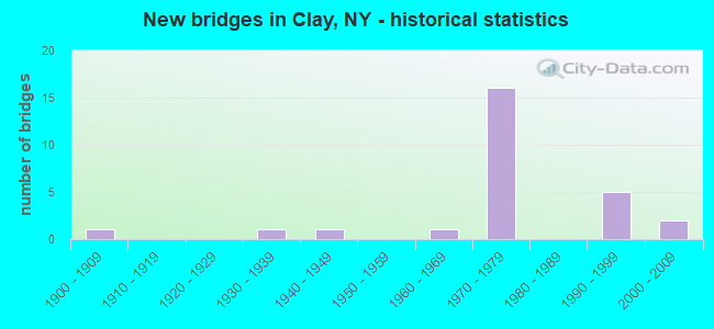
- New bridges - historical statistics
- 11900-1909
- 11930-1939
- 11940-1949
- 11960-1969
- 161970-1979
- 51990-1999
- 22000-2009

- Reconstructed bridges - Historical Statistics
- 21980-1989
- 11990-1999
- 22000-2009
- 12010-2019


- Bridge Condition - Deck
- 5.6%Excellent
- 5.6%Very good
- 22.2%Good
- 61.1%Satisfactory
- 5.6%Fair

- Bridge Condition - Superstructure
- 5.6%Excellent
- 11.1%Very good
- 27.8%Good
- 38.9%Satisfactory
- 11.1%Fair
- 5.6%Poor

- Bridge Condition - Substructure
- 5.6%Excellent
- 16.7%Very good
- 44.4%Good
- 22.2%Satisfactory
- 11.1%Fair

- Bridge Condition - Channel
- 21.4%Very good
- 64.3%Good
- 14.3%Satisfactory

- Bridge Condition - Culverts
- 33.3%Good
- 33.3%Satisfactory
- 33.3%Fair
Find on map >> Show street view
Structure Number: 102195, Location: 1.0 MI E JCT RTS 31 & 481 (Lat: 43.186283, Lng: -76.213692), Route carried "on" structure: State highway 31, Year Built: 2004, Status: Open, Structure Length: 2.47m (8.10ft), Average Daily Traffic: 9,551 (year 2020), Truck Traffic: 6%, Average Future Daily Traffic: 9,595 (year 2040), Design Load: HS 25 or greater, Features Intersected: Mud Creek
Minimum Vertical Clearance: 30+ m (98+ ft), Kilometerpoint: 33.596, Lanes on structure: 4, Base Highway Network: Yes, Owner: State Highway Agency, Approaching Roadway Width: 22.3m (73.2ft), Skew: 21 degrees, Material/Design: Prestressed concrete, Design/Construction: Box Beam or Girders - Multiple, Number Of Spans In Main Unit: 1, Length of Maximum Span: 23.8m (78.1ft), Curb or Sidewalk Widths: Left: 1.8m (5.9ft), Right: 0.0m, Curb-To-Curb Width: 22.3m (73.2ft), Out-to-Out Width: 24.9m (81.7ft)
Condition: Deck: Good, Superstructure: Very good, Substructure: Excellent, Channel: Good, Inventory Rating: 61.7 metric tons, Method Used To Determine Inventory Rating: Load Factor (LF), Structural Evaluation: Equal to present desirable criteria, Deck Geometry: Superior to present desirable criteria, Waterway Adequacy: Equal to present desirable criteria, Approach Roadway Alignment: Equal to present desirable criteria, Length Of Structure Improvement: 2.46m (8.07ft), Designated Inspection Frequency: Every 24 months, Inspection Date: October 2020, Bridge Improvement Cost: $1,873,000, Roadway Improvement Cost: $1,097,000, Total Project Cost: $2,969,000 ( Estimate for 2021), Wearing Surface/Protective System: Wearing Surface: Monolithic Concrete
Find on map >> Show street view
Structure Number: 1061711, Location: 4 MI NW JCT SH 481 & I81 (Lat: 43.168975, Lng: -76.181056), Route carried "on" structure: State highway 481, Year Built: 1972, Status: Open, Structure Length: 4.60m (15.09ft), Average Daily Traffic: 10,389 (year 2015), Truck Traffic: 5%, Average Future Daily Traffic: 13,534 (year 2040), Design Load: HS 20, Features Intersected: CSXT-MONTREAL SEC
Minimum Vertical Clearance: 30+ m (98+ ft), Kilometerpoint: 6.452, Lanes on structure: 2, Base Highway Network: Yes, Owner: State Highway Agency, Approaching Roadway Width: 12.8m (42.0ft), Material/Design: Steel, Design/Construction: Stringer/Multi-beam, Number Of Spans In Main Unit: 3, Length of Maximum Span: 14.6m (47.9ft), Curb-To-Curb Width: 12.5m (41.0ft), Out-to-Out Width: 13.4m (44.0ft)
Condition: Deck: Satisfactory, Superstructure: Satisfactory, Substructure: Fair, Operating Rating: 66.2 metric tons, Method Used To Determine Operating Rating: Load Factor (LF), Inventory Rating: 39.9 metric tons, Method Used To Determine Inventory Rating: Load Factor (LF), Structural Evaluation: Somewhat better than minimum adequacy, Deck Geometry: Better than present minimum criteria, Underclear: Better than present minimum criteria, Approach Roadway Alignment: Equal to present desirable criteria, Length Of Structure Improvement: 4.60m (15.09ft), Designated Inspection Frequency: Every 24 months, Inspection Date: July 2021, Bridge Improvement Cost: $1,266,000, Roadway Improvement Cost: $741,000, Total Project Cost: $2,007,000 ( Estimate for 2021), Deck Structure Type: Concrete Cast-file-Place, Wearing Surface/Protective System: Wearing Surface: Latex Concrete
Find on map >> Show street view
Structure Number: 1061712, Location: 4 MI NW JCT SH 481 & I81 (Lat: 43.169161, Lng: -76.180964), Route carried "on" structure: State highway 481, Year Built: 1972, Status: Open, Structure Length: 4.60m (15.09ft), Average Daily Traffic: 10,389 (year 2015), Truck Traffic: 5%, Average Future Daily Traffic: 13,534 (year 2040), Design Load: HS 20, Features Intersected: CSXT-MONTREAL SEC
Minimum Vertical Clearance: 30+ m (98+ ft), Kilometerpoint: 6.452, Lanes on structure: 2, Base Highway Network: Yes, Owner: State Highway Agency, Approaching Roadway Width: 12.8m (42.0ft), Material/Design: Steel, Design/Construction: Stringer/Multi-beam, Number Of Spans In Main Unit: 3, Length of Maximum Span: 14.6m (47.9ft), Curb-To-Curb Width: 12.5m (41.0ft), Out-to-Out Width: 13.4m (44.0ft)
Condition: Deck: Good, Superstructure: Poor, Substructure: Fair, Operating Rating: 54.4 metric tons, Method Used To Determine Operating Rating: Load Factor (LF), Inventory Rating: 32.7 metric tons, Method Used To Determine Inventory Rating: Load Factor (LF), Structural Evaluation: Meets minimum limits, Deck Geometry: Better than present minimum criteria, Underclear: Better than present minimum criteria, Approach Roadway Alignment: Equal to present desirable criteria, Length Of Structure Improvement: 4.60m (15.09ft), Designated Inspection Frequency: Every 24 months, Inspection Date: July 2021, Bridge Improvement Cost: $1,266,000, Roadway Improvement Cost: $741,000, Total Project Cost: $2,007,000 ( Estimate for 2021), Deck Structure Type: Concrete Cast-file-Place, Wearing Surface/Protective System: Wearing Surface: Latex Concrete
Find on map >> Show street view
Structure Number: 106176, Location: JCT OF RTS 31 + 481 (Lat: 43.185564, Lng: -76.231772), Route carried "on" structure: State highway 31, Year Built: 1972, Status: Open, Structure Length: 7.65m (25.10ft), Average Daily Traffic: 22,002 (year 2017), Truck Traffic: 3%, Average Future Daily Traffic: 22,105 (year 2040), Design Load: HS 20, Features Intersected: 481 481 33011069 SB, RTE
Minimum Vertical Clearance: 30+ m (98+ ft), Kilometerpoint: 32.116, Lanes on structure: 4, Lanes under structure: 4, Base Highway Network: Yes, Owner: State Highway Agency, Approaching Roadway Width: 23.2m (76.1ft), Skew: 2 degrees, Material/Design: Steel, Design/Construction: Stringer/Multi-beam, Number Of Spans In Main Unit: 2, Length of Maximum Span: 37.4m (122.7ft), Curb-To-Curb Width: 22.9m (75.1ft), Out-to-Out Width: 23.8m (78.1ft)
Condition: Deck: Satisfactory, Superstructure: Satisfactory, Substructure: Good, Operating Rating: 86.2 metric tons, Method Used To Determine Operating Rating: Load Factor (LF), Inventory Rating: 51.7 metric tons, Method Used To Determine Inventory Rating: Load Factor (LF), Structural Evaluation: Equal to present minimum criteria, Deck Geometry: Superior to present desirable criteria, Underclear: High priority of corrective action, Approach Roadway Alignment: Equal to present desirable criteria, Length Of Structure Improvement: 7.65m (25.10ft), Designated Inspection Frequency: Every 24 months, Inspection Date: September 2020, Bridge Improvement Cost: $3,705,000, Roadway Improvement Cost: $2,170,000, Total Project Cost: $5,875,000 ( Estimate for 2021), Deck Structure Type: Concrete Cast-file-Place, Wearing Surface/Protective System: Wearing Surface: Monolithic Concrete
Find on map >> Show street view
Structure Number: 106177, Location: 1.5 MI SE JCT RTS 481 +31 (Lat: 43.172625, Lng: -76.209267), Route carried "on" structure: County highway , Year Built: 1972, Status: Open, Structure Length: 8.87m (29.10ft), Average Daily Traffic: 10,796 (year 2020), Truck Traffic: 4%, Average Future Daily Traffic: 13,114 (year 2040), Design Load: HS 20, Features Intersected: 481 481 33011055, RTE 48, Facility Carried by Structure: MORGAN ROAD
Minimum Vertical Clearance: 30+ m (98+ ft), Kilometerpoint: 3.459, Lanes on structure: 4, Lanes under structure: 4, Owner: State Highway Agency, Approaching Roadway Width: 20.4m (66.9ft), Skew: 3 degrees, Material/Design: Steel, Design/Construction: Stringer/Multi-beam, Number Of Spans In Main Unit: 2, Length of Maximum Span: 45.4m (149.0ft), Curb-To-Curb Width: 20.4m (66.9ft), Out-to-Out Width: 21.3m (69.9ft)
Condition: Deck: Satisfactory, Superstructure: Satisfactory, Substructure: Satisfactory, Operating Rating: 87.1 metric tons, Method Used To Determine Operating Rating: Load Factor (LF), Inventory Rating: 51.7 metric tons, Method Used To Determine Inventory Rating: Load Factor (LF), Structural Evaluation: Equal to present minimum criteria, Deck Geometry: Superior to present desirable criteria, Underclear: High priority of corrective action, Approach Roadway Alignment: Equal to present desirable criteria, Length Of Structure Improvement: 8.86m (29.07ft), Designated Inspection Frequency: Every 24 months, Inspection Date: September 2021, Bridge Improvement Cost: $3,975,000, Roadway Improvement Cost: $2,328,000, Total Project Cost: $6,303,000 ( Estimate for 2021), Deck Structure Type: Concrete Cast-file-Place, Wearing Surface/Protective System: Wearing Surface: Latex Concrete
Find on map >> Show street view
Structure Number: 106178, Location: 2.0 MI SE JCT RTS 481 +31 (Lat: 43.171169, Lng: -76.197972), Route carried "on" structure: County highway , Year Built: 1972, Status: Open, Structure Length: 7.32m (24.02ft), Average Daily Traffic: 6,300 (year 2020), Truck Traffic: 4%, Average Future Daily Traffic: 7,794 (year 2040), Design Load: HS 20, Features Intersected: 481 481 33011049 NB, RTE, Facility Carried by Structure: HENRY CLAY BLVD
Minimum Vertical Clearance: 30+ m (98+ ft), Kilometerpoint: 3.443, Lanes on structure: 2, Lanes under structure: 4, Owner: State Highway Agency, Approaching Roadway Width: 14.6m (47.9ft), Skew: 1 degrees, Material/Design: Steel, Design/Construction: Stringer/Multi-beam, Number Of Spans In Main Unit: 2, Length of Maximum Span: 36.9m (121.1ft), Curb-To-Curb Width: 14.3m (46.9ft), Out-to-Out Width: 15.2m (49.9ft)
Condition: Deck: Very good, Superstructure: Satisfactory, Substructure: Good, Operating Rating: 61.2 metric tons, Method Used To Determine Operating Rating: Load and Resistance Factor Rating (LRFR) rating reported by rating factor(RF) method using HL-93 loadings, Inventory Rating: 47.3 metric tons, Method Used To Determine Inventory Rating: Load and Resistance Factor Rating (LRFR) rating reported by rating factor(RF) method using HL-93 loadings, Structural Evaluation: Equal to present minimum criteria, Deck Geometry: Superior to present desirable criteria, Underclear: Meets minimum limits, Approach Roadway Alignment: Equal to present desirable criteria, Length Of Structure Improvement: 7.31m (23.98ft), Designated Inspection Frequency: Every 24 months, Inspection Date: April 2020, Bridge Improvement Cost: $2,327,000, Roadway Improvement Cost: $1,363,000, Total Project Cost: $3,689,000 ( Estimate for 2021), Deck Structure Type: Concrete Cast-file-Place, Wearing Surface/Protective System: Wearing Surface: Latex Concrete
Find on map >> Show street view
Structure Number: 106464, Location: 0.6 MI NW JCT RTS 481 +31 (Lat: 43.192519, Lng: -76.237392), Route carried "on" structure: County highway , Year Built: 1970, Status: Open, Structure Length: 6.86m (22.51ft), Average Daily Traffic: 1,263 (year 2020), Truck Traffic: 7%, Average Future Daily Traffic: 1,562 (year 2040), Design Load: HS 20, Features Intersected: 481 481 33011075, RTE 48, Facility Carried by Structure: VERPLANK ROAD
Minimum Vertical Clearance: 30+ m (98+ ft), Kilometerpoint: 3.282, Lanes on structure: 2, Lanes under structure: 4, Owner: State Highway Agency, Approaching Roadway Width: 11.0m (36.1ft), Skew: 3 degrees, Material/Design: Steel, Design/Construction: Stringer/Multi-beam, Number Of Spans In Main Unit: 2, Length of Maximum Span: 33.2m (108.9ft), Curb-To-Curb Width: 10.7m (35.1ft), Out-to-Out Width: 11.6m (38.1ft)
Condition: Deck: Satisfactory, Superstructure: Good, Substructure: Good, Operating Rating: 69.9 metric tons, Method Used To Determine Operating Rating: Load Factor (LF), Inventory Rating: 41.7 metric tons, Method Used To Determine Inventory Rating: Load Factor (LF), Structural Evaluation: Better than present minimum criteria, Deck Geometry: Equal to present minimum criteria, Underclear: Somewhat better than minimum adequacy, Approach Roadway Alignment: Equal to present desirable criteria, Length Of Structure Improvement: 6.85m (22.47ft), Designated Inspection Frequency: Every 24 months, Inspection Date: March 2020, Bridge Improvement Cost: $1,847,000, Roadway Improvement Cost: $1,082,000, Total Project Cost: $2,928,000 ( Estimate for 2021), Deck Structure Type: Concrete Cast-file-Place, Wearing Surface/Protective System: Wearing Surface: Monolithic Concrete
Find on map >> Show street view
Structure Number: 106801, Location: 2.3 MI SE JCT RTS 481$ 31 (Lat: 43.171342, Lng: -76.197250), Route carried "on" structure: State highway 481, Year Built: 1993, Status: Open, Structure Length: 1.34m (4.40ft), Average Daily Traffic: 20,777 (year 2015), Truck Traffic: 5%, Average Future Daily Traffic: 27,068 (year 2040), Design Load: HS 25 or greater, Features Intersected: MUD CREEK
Minimum Vertical Clearance: 30+ m (98+ ft), Kilometerpoint: 7.884, Lanes on structure: 4, Base Highway Network: Yes, Owner: State Highway Agency, Approaching Roadway Width: 23.2m (76.1ft), Skew: 21 degrees, Material/Design: Concrete, Design/Construction: Culvert, Number Of Spans In Main Unit: 2, Length of Maximum Span: 6.4m (21.0ft)
Condition: Channel: Very good, Culverts: Fair, Operating Rating: 76.7 metric tons, Method Used To Determine Operating Rating: Field evaluation and documented engineering judgment, Inventory Rating: 36.7 metric tons, Method Used To Determine Inventory Rating: Field evaluation and documented engineering judgment, Structural Evaluation: Somewhat better than minimum adequacy, Waterway Adequacy: Equal to present minimum criteria, Approach Roadway Alignment: Equal to present desirable criteria, Length Of Structure Improvement: 1.34m (4.40ft), Designated Inspection Frequency: Every 24 months, Underwater Inspection Frequency: Every 60 months, Inspection Date: October 2021, Underwater Inspection Date: June 2018, Bridge Improvement Cost: $720,000, Roadway Improvement Cost: $421,000, Total Project Cost: $1,141,000 ( Estimate for 2021)
Find on map >> Show street view
Structure Number: 106802, Location: 0.3 MI NE JCT RTS 481+11 (Lat: 43.150792, Lng: -76.134875), Route carried "on" structure: State highway 481, Year Built: 1972, Status: Open, Structure Length: 2.29m (7.51ft), Average Daily Traffic: 20,777 (year 2015), Truck Traffic: 5%, Average Future Daily Traffic: 27,068 (year 2040), Design Load: HS 20, Features Intersected: MUD CREEK
Minimum Vertical Clearance: 30+ m (98+ ft), Kilometerpoint: 2.124, Lanes on structure: 4, Base Highway Network: Yes, Owner: State Highway Agency, Approaching Roadway Width: 25.6m (84.0ft), Skew: 24 degrees, Material/Design: Steel, Design/Construction: Culvert, Number Of Spans In Main Unit: 4, Length of Maximum Span: 3.9m (12.8ft)
Condition: Channel: Good, Culverts: Good, Operating Rating: 75.4 metric tons, Method Used To Determine Operating Rating: Field evaluation and documented engineering judgment, Inventory Rating: 32.7 metric tons, Method Used To Determine Inventory Rating: Field evaluation and documented engineering judgment, Structural Evaluation: Better than present minimum criteria, Waterway Adequacy: Superior to present desirable criteria, Approach Roadway Alignment: Equal to present desirable criteria, Length Of Structure Improvement: 2.28m (7.48ft), Designated Inspection Frequency: Every 24 months, Underwater Inspection Frequency: Every 60 months, Inspection Date: August 2020, Underwater Inspection Date: June 2020, Bridge Improvement Cost: $1,059,000, Roadway Improvement Cost: $620,000, Total Project Cost: $1,678,000 ( Estimate for 2021)
Find on map >> Show street view
Structure Number: 331281, Location: .5 M N SH 31 IN EUCLID (Lat: 43.194364, Lng: -76.212208), Route carried "on" structure: County highway , Year Built: 1996, Status: Open, Structure Length: 1.10m (3.61ft), Average Daily Traffic: 995 (year 2019), Truck Traffic: 3%, Average Future Daily Traffic: 1,231 (year 2040), Design Load: HS 25 or greater, Features Intersected: MUD CREEK, Facility Carried by Structure: VER PLANK ROAD
Minimum Vertical Clearance: 30+ m (98+ ft), Kilometerpoint: 5.374, Lanes on structure: 2, Owner: County Highway Agency, Approaching Roadway Width: 10.1m (33.1ft), Material/Design: Concrete, Design/Construction: Frame, Number Of Spans In Main Unit: 1, Length of Maximum Span: 10.6m (34.8ft), Curb-To-Curb Width: 10.1m (33.1ft), Out-to-Out Width: 10.8m (35.4ft)
Condition: Deck: Satisfactory, Superstructure: Satisfactory, Substructure: Very good, Channel: Very good, Operating Rating: 22.7 metric tons, Method Used To Determine Operating Rating: Load and Resistance Factor Rating (LRFR) rating reported by rating factor(RF) method using HL-93 loadings, Inventory Rating: 17.5 metric tons, Method Used To Determine Inventory Rating: Load and Resistance Factor Rating (LRFR) rating reported by rating factor(RF) method using HL-93 loadings, Structural Evaluation: Meets minimum limits, Deck Geometry: Equal to present minimum criteria, Waterway Adequacy: Equal to present minimum criteria, Approach Roadway Alignment: Equal to present minimum criteria, Length Of Structure Improvement: 1.09m (3.58ft), Designated Inspection Frequency: Every 24 months, Inspection Date: March 2021, Bridge Improvement Cost: $456,000, Roadway Improvement Cost: $267,000, Total Project Cost: $723,000 ( Estimate for 2021), Wearing Surface/Protective System: Wearing Surface: Bituminous
Find on map >> Show street view
Structure Number: 331283, Location: 2 MI NORTH OF EUCLID (Lat: 43.204539, Lng: -76.214242), Route carried "on" structure: County highway , Year Built: 1939, Year Reconstructed: 2002, Status: Open, Structure Length: 1.71m (5.61ft), Average Daily Traffic: 1,675 (year 2020), Truck Traffic: 5%, Average Future Daily Traffic: 2,345 (year 2040), Features Intersected: MUD CREEK, Facility Carried by Structure: OAK ORCHARD ROAD
Minimum Vertical Clearance: 30+ m (98+ ft), Kilometerpoint: 0.322, Lanes on structure: 2, Owner: County Highway Agency, Approaching Roadway Width: 10.4m (34.1ft), Material/Design: Prestressed concrete, Design/Construction: Box Beam or Girders - Multiple, Number Of Spans In Main Unit: 1, Length of Maximum Span: 15.8m (51.8ft), Curb-To-Curb Width: 10.4m (34.1ft), Out-to-Out Width: 11.4m (37.4ft)
Condition: Deck: Satisfactory, Superstructure: Very good, Substructure: Good, Channel: Good, Operating Rating: 98.9 metric tons, Method Used To Determine Operating Rating: Load Factor (LF), Inventory Rating: 59.0 metric tons, Method Used To Determine Inventory Rating: Load Factor (LF), Structural Evaluation: Better than present minimum criteria, Deck Geometry: Equal to present minimum criteria, Waterway Adequacy: Equal to present minimum criteria, Approach Roadway Alignment: Equal to present minimum criteria, Length Of Structure Improvement: 1.70m (5.58ft), Designated Inspection Frequency: Every 24 months, Inspection Date: September 2020, Bridge Improvement Cost: $995,000, Roadway Improvement Cost: $583,000, Total Project Cost: $1,577,000 ( Estimate for 2021), Deck Structure Type: Concrete Cast-file-Place, Wearing Surface/Protective System: Wearing Surface: Integral Concrete
Find on map >> Show street view
Structure Number: 331284, Location: 2 MI NE EXIT 38 OF I90 (Lat: 43.141611, Lng: -76.194331), Route carried "on" structure: County highway , Year Built: 1967, Year Reconstructed: 2016, Status: Open, Structure Length: 4.85m (15.91ft), Average Daily Traffic: 12,201 (year 2020), Truck Traffic: 5%, Average Future Daily Traffic: 12,258 (year 2040), Features Intersected: CSX TRANSPRTATION, Facility Carried by Structure: BUCKLEY ROAD
Minimum Vertical Clearance: 30+ m (98+ ft), Kilometerpoint: 1.191, Lanes on structure: 2, Owner: County Highway Agency, Approaching Roadway Width: 9.8m (32.2ft), Skew: 1 degrees, Material/Design: Steel, Design/Construction: Stringer/Multi-beam, Number Of Spans In Main Unit: 3, Length of Maximum Span: 16.5m (54.1ft), Curb-To-Curb Width: 9.8m (32.2ft), Out-to-Out Width: 10.8m (35.4ft)
Condition: Deck: Excellent, Superstructure: Excellent, Substructure: Very good, Operating Rating: 75.3 metric tons, Method Used To Determine Operating Rating: Load Factor (LF), Inventory Rating: 45.4 metric tons, Method Used To Determine Inventory Rating: Load Factor (LF), Structural Evaluation: Equal to present desirable criteria, Deck Geometry: Meets minimum limits, Underclear: Equal to present minimum criteria, Approach Roadway Alignment: Equal to present desirable criteria, Length Of Structure Improvement: 4.84m (15.88ft), Designated Inspection Frequency: Every 24 months, Inspection Date: June 2021, Bridge Improvement Cost: $1,064,000, Roadway Improvement Cost: $623,000, Total Project Cost: $1,686,000 ( Estimate for 2021), Deck Structure Type: Concrete Cast-file-Place, Wearing Surface/Protective System: Wearing Surface: Integral Concrete, Deck Protection: Epoxy Coated Reinforcing
Find on map >> Show street view
Structure Number: 335906, Location: 3.5 MI WEST OF CICERO (Lat: 43.173831, Lng: -76.199519), Route carried "on" structure: County highway , Year Built: 1972, Year Reconstructed: 1994, Status: Open, Structure Length: 2.44m (8.01ft), Average Daily Traffic: 6,300 (year 2020), Truck Traffic: 4%, Average Future Daily Traffic: 7,794 (year 2040), Design Load: HS 20, Features Intersected: MUD CREEK, Facility Carried by Structure: HENRY CLAY BLVD
Minimum Vertical Clearance: 30+ m (98+ ft), Kilometerpoint: 3.765, Lanes on structure: 2, Owner: County Highway Agency, Approaching Roadway Width: 13.1m (43.0ft), Skew: 2 degrees, Material/Design: Aluminum, Iron, Design/Construction: Culvert, Number Of Spans In Main Unit: 4, Length of Maximum Span: 4.2m (13.8ft)
Condition: Channel: Satisfactory, Culverts: Satisfactory, Operating Rating: 75.6 metric tons, Method Used To Determine Operating Rating: Field evaluation and documented engineering judgment, Inventory Rating: 32.7 metric tons, Method Used To Determine Inventory Rating: Field evaluation and documented engineering judgment, Structural Evaluation: Equal to present minimum criteria, Waterway Adequacy: Somewhat better than minimum adequacy, Approach Roadway Alignment: Equal to present desirable criteria, Length Of Structure Improvement: 2.43m (7.97ft), Designated Inspection Frequency: Every 24 months, Underwater Inspection Frequency: Every 60 months, Inspection Date: December 2020, Underwater Inspection Date: June 2018, Bridge Improvement Cost: $578,000, Roadway Improvement Cost: $338,000, Total Project Cost: $916,000 ( Estimate for 2021)
Find on map >> Show street view
Structure Number: 402742, Location: RTE 481 ONOND-OSWEGO CL (Lat: 43.201819, Lng: -76.277953), Route carried "on" structure: County highway , Year Built: 1940, Year Reconstructed: 1992, Status: Open, Structure Length: 11.28m (37.01ft), Average Daily Traffic: 4,685 (year 2020), Truck Traffic: 4%, Average Future Daily Traffic: 5,691 (year 2040), Design Load: HS 20, Features Intersected: ONEIDA RIVER, Facility Carried by Structure: COUNTY ROUTE 57
Minimum Vertical Clearance: 4.41m (14.47ft), Kilometerpoint: 12.856, Lanes on structure: 2, Owner: County Highway Agency, Approaching Roadway Width: 7.3m (24.0ft), Navigation Control: Yes ( Vertical Clearance: 6.0m (19.7ft), Horizontal Clearance: 50.5m (165.7ft)), Material/Design: Steel, Design/Construction: Truss - Thru, Number Of Spans In Main Unit: 1, Number Of Approach Spans: 2, Length of Maximum Span: 76.2m (250.0ft), Curb or Sidewalk Widths: Left: 0.7m (2.3ft), Right: 0.7m (2.3ft), Curb-To-Curb Width: 7.3m (24.0ft), Out-to-Out Width: 9.4m (30.8ft)
Condition: Deck: Satisfactory, Superstructure: Fair, Substructure: Satisfactory, Channel: Very good, Operating Rating: 64.4 metric tons, Method Used To Determine Operating Rating: Load Factor (LF), Inventory Rating: 38.1 metric tons, Method Used To Determine Inventory Rating: Load Factor (LF), Structural Evaluation: Somewhat better than minimum adequacy, Deck Geometry: High priority of replacement, Waterway Adequacy: Equal to present desirable criteria, Approach Roadway Alignment: Equal to present desirable criteria, Length Of Structure Improvement: 11.27m (36.98ft), Designated Inspection Frequency: Every 24 months, Critical Feature Inspection Frequency: Every 12 months, Inspection Date: July 2021, Critical Feature Inspection Date: July 2021, Bridge Improvement Cost: $6,572,000, Roadway Improvement Cost: $3,849,000, Total Project Cost: $10,421,000 ( Estimate for 2021), Deck Structure Type: Concrete Cast-file-Place, Wearing Surface/Protective System: Wearing Surface: Epoxy Overlay, Deck Protection: Epoxy Coated Reinforcing
Find on map >> Show street view
Structure Number: 4051011, Location: 481 SB AT ONON&OSWEGO CL (Lat: 43.210636, Lng: -76.266144), Route carried "on" structure: State highway 481, Year Built: 1970, Status: Open, Structure Length: 22.40m (73.49ft), Average Daily Traffic: 8,029 (year 2010), Truck Traffic: 8%, Average Future Daily Traffic: 10,460 (year 2040), Design Load: HS 20, Features Intersected: BONSTEAD ROAD, ONEIDA RI
Minimum Vertical Clearance: 30+ m (98+ ft), Kilometerpoint: 15.205, Lanes on structure: 2, Lanes under structure: 2, Base Highway Network: Yes, Owner: State Highway Agency, Approaching Roadway Width: 11.9m (39.0ft), Skew: 2 degrees, Navigation Control: Yes ( Vertical Clearance: 6.0m (19.7ft), Horizontal Clearance: 60.9m (199.8ft)), Material/Design: Steel, Design/Construction: Stringer/Multi-beam, Number Of Spans In Main Unit: 4, Length of Maximum Span: 70.1m (230.0ft), Curb-To-Curb Width: 11.9m (39.0ft), Out-to-Out Width: 12.8m (42.0ft)
Condition: Deck: Good, Superstructure: Satisfactory, Substructure: Good, Channel: Good, Operating Rating: 68.9 metric tons, Method Used To Determine Operating Rating: Load Factor (LF), Inventory Rating: 41.7 metric tons, Method Used To Determine Inventory Rating: Load Factor (LF), Structural Evaluation: Equal to present minimum criteria, Deck Geometry: Equal to present minimum criteria, Underclear: Equal to present minimum criteria, Waterway Adequacy: Superior to present desirable criteria, Approach Roadway Alignment: Equal to present desirable criteria, Length Of Structure Improvement: 22.40m (73.49ft), Designated Inspection Frequency: Every 24 months, Underwater Inspection Frequency: Every 60 months, Inspection Date: September 2021, Underwater Inspection Date: July 2017, Bridge Improvement Cost: $5,631,000, Roadway Improvement Cost: $3,298,000, Total Project Cost: $8,929,000 ( Estimate for 2021), Deck Structure Type: Concrete Cast-file-Place, Wearing Surface/Protective System: Wearing Surface: Monolithic Concrete
Find on map >> Show street view
Structure Number: 4051012, Location: I481NB AT ONON+OSWEGO CL (Lat: 43.210794, Lng: -76.265939), Route carried "on" structure: State highway 481, Year Built: 1970, Year Reconstructed: 2014, Status: Open, Structure Length: 22.40m (73.49ft), Average Daily Traffic: 9,289 (year 2015), Truck Traffic: 7%, Average Future Daily Traffic: 13,567 (year 2040), Design Load: HS 20, Features Intersected: BONSTEAD ROAD, ONEIDA RI
Minimum Vertical Clearance: 30+ m (98+ ft), Kilometerpoint: 0.000, Lanes on structure: 2, Lanes under structure: 2, Base Highway Network: Yes, Owner: State Highway Agency, Approaching Roadway Width: 12.8m (42.0ft), Skew: 2 degrees, Navigation Control: Yes ( Vertical Clearance: 6.0m (19.7ft), Horizontal Clearance: 60.9m (199.8ft)), Material/Design: Steel, Design/Construction: Stringer/Multi-beam, Number Of Spans In Main Unit: 4, Length of Maximum Span: 70.1m (230.0ft), Curb-To-Curb Width: 11.9m (39.0ft), Out-to-Out Width: 12.8m (42.0ft)
Condition: Deck: Satisfactory, Superstructure: Satisfactory, Substructure: Good, Channel: Good, Operating Rating: 57.2 metric tons, Method Used To Determine Operating Rating: Load Factor (LF), Inventory Rating: 28.1 metric tons, Method Used To Determine Inventory Rating: Load Factor (LF), Structural Evaluation: Equal to present minimum criteria, Deck Geometry: Better than present minimum criteria, Underclear: Equal to present minimum criteria, Waterway Adequacy: Superior to present desirable criteria, Approach Roadway Alignment: Equal to present desirable criteria, Length Of Structure Improvement: 22.40m (73.49ft), Designated Inspection Frequency: Every 24 months, Underwater Inspection Frequency: Every 60 months, Inspection Date: September 2021, Underwater Inspection Date: July 2017, Bridge Improvement Cost: $5,631,000, Roadway Improvement Cost: $3,298,000, Total Project Cost: $8,929,000 ( Estimate for 2021), Deck Structure Type: Concrete Cast-file-Place, Wearing Surface/Protective System: Wearing Surface: Monolithic Concrete
Find on map >> Show street view
Structure Number: 443302, Location: 2.3 MI W JCT US11 & BG CL (Lat: 43.243283, Lng: -76.183181), Route carried "on" structure: County highway , Year Built: 1990, Status: Open, Structure Length: 9.30m (30.51ft), Average Daily Traffic: 1,573 (year 2019), Truck Traffic: 6%, Average Future Daily Traffic: 1,946 (year 2040), Design Load: HS 20, Features Intersected: ERIE CANAL CUT, Facility Carried by Structure: CAUGHDENOY ROAD
Minimum Vertical Clearance: 30+ m (98+ ft), Kilometerpoint: 5.422, Lanes on structure: 2, Owner: State Highway Agency, Approaching Roadway Width: 10.4m (34.1ft), Navigation Control: Yes ( Vertical Clearance: 6.0m (19.7ft), Horizontal Clearance: 31.6m (103.7ft)), Material/Design: Steel continuous, Design/Construction: Stringer/Multi-beam, Number Of Spans In Main Unit: 3, Length of Maximum Span: 40.2m (131.9ft), Curb-To-Curb Width: 9.8m (32.2ft), Out-to-Out Width: 10.4m (34.1ft)
Condition: Deck: Satisfactory, Superstructure: Good, Substructure: Satisfactory, Channel: Good, Operating Rating: 81.6 metric tons, Method Used To Determine Operating Rating: Load Factor (LF), Inventory Rating: 47.2 metric tons, Method Used To Determine Inventory Rating: Load Factor (LF), Structural Evaluation: Equal to present minimum criteria, Deck Geometry: Somewhat better than minimum adequacy, Waterway Adequacy: Superior to present desirable criteria, Approach Roadway Alignment: Equal to present desirable criteria, Length Of Structure Improvement: 9.29m (30.48ft), Designated Inspection Frequency: Every 24 months, Underwater Inspection Frequency: Every 60 months, Inspection Date: August 2021, Underwater Inspection Date: July 2020, Bridge Improvement Cost: $1,994,000, Roadway Improvement Cost: $1,168,000, Total Project Cost: $3,162,000 ( Estimate for 2021), Deck Structure Type: Concrete Cast-file-Place, Wearing Surface/Protective System: Wearing Surface: Integral Concrete, Deck Protection: Epoxy Coated Reinforcing
Find on map >> Show street view
Structure Number: 443303, Location: 3.4 MI W JCT 11 + BARGE C (Lat: 43.236272, Lng: -76.203042), Route carried "on" structure: County highway , Year Built: 1908, Year Reconstructed: 2000, Status: Posted for load-capacity, Structure Length: 7.83m (25.69ft), Truck Traffic: 8%, Design Load: H 20, Features Intersected: ERIE CANAL CUT, Facility Carried by Structure: BLACK CREEK ROAD
Minimum Vertical Clearance: 4.01m (13.16ft), Kilometerpoint: 1.883, Lanes on structure: 1, Owner: State Highway Agency, Approaching Roadway Width: 8.5m (27.9ft), Navigation Control: Yes ( Vertical Clearance: 6.0m (19.7ft), Horizontal Clearance: 38.1m (125.0ft)), Material/Design: Steel, Design/Construction: Truss - Thru, Number Of Spans In Main Unit: 1, Number Of Approach Spans: 4, Length of Maximum Span: 40.8m (133.9ft), Curb-To-Curb Width: 4.2m (13.8ft), Out-to-Out Width: 5.4m (17.7ft)
Condition: Deck: Fair, Superstructure: Fair, Substructure: Satisfactory, Channel: Satisfactory, Operating Rating: 39.0 metric tons, Method Used To Determine Operating Rating: Load Factor (LF), Inventory Rating: 22.7 metric tons, Method Used To Determine Inventory Rating: Load Factor (LF), Structural Evaluation: Somewhat better than minimum adequacy, Deck Geometry: High priority of corrective action, Waterway Adequacy: Superior to present desirable criteria, Approach Roadway Alignment: Meets minimum limits, Length Of Structure Improvement: 7.83m (25.69ft), Designated Inspection Frequency: Every 24 months, Critical Feature Inspection Frequency: Every 24 months, Underwater Inspection Frequency: Every 60 months, Inspection Date: August 2020, Critical Feature Inspection Date: August 2020, Underwater Inspection Date: July 2021, Bridge Improvement Cost: $2,608,000, Roadway Improvement Cost: $1,527,000, Total Project Cost: $4,136,000 ( Estimate for 2021), Deck Structure Type: Concrete Cast-file-Place, Wearing Surface/Protective System: Wearing Surface: Integral Concrete, Deck Protection: Epoxy Coated Reinforcing
Find on map >> Show street view
Structure Number: 443304, Location: 2.7 MI E JCT 481 &BARGE C (Lat: 43.205294, Lng: -76.217639), Route carried "on" structure: County highway , Year Built: 1991, Status: Open, Structure Length: 13.90m (45.60ft), Average Daily Traffic: 7,176 (year 2020), Truck Traffic: 4%, Average Future Daily Traffic: 10,032 (year 2040), Design Load: HS 20, Features Intersected: ONEIDA RIVER, Facility Carried by Structure: MORGAN ROAD
Minimum Vertical Clearance: 30+ m (98+ ft), Kilometerpoint: 7.160, Lanes on structure: 2, Owner: State Highway Agency, Approaching Roadway Width: 10.4m (34.1ft), Skew: 1 degrees, Navigation Control: Yes ( Vertical Clearance: 6.0m (19.7ft), Horizontal Clearance: 57.9m (190.0ft)), Material/Design: Steel continuous, Design/Construction: Stringer/Multi-beam, Number Of Spans In Main Unit: 3, Length of Maximum Span: 64.9m (212.9ft), Curb-To-Curb Width: 10.4m (34.1ft), Out-to-Out Width: 11.0m (36.1ft)
Condition: Deck: Satisfactory, Superstructure: Good, Substructure: Good, Channel: Good, Operating Rating: 76.2 metric tons, Method Used To Determine Operating Rating: Load Factor (LF), Inventory Rating: 40.8 metric tons, Method Used To Determine Inventory Rating: Load Factor (LF), Structural Evaluation: Better than present minimum criteria, Deck Geometry: Meets minimum limits, Waterway Adequacy: Superior to present desirable criteria, Approach Roadway Alignment: Equal to present desirable criteria, Length Of Structure Improvement: 13.89m (45.57ft), Designated Inspection Frequency: Every 24 months, Underwater Inspection Frequency: Every 60 months, Inspection Date: July 2021, Underwater Inspection Date: June 2019, Bridge Improvement Cost: $3,053,000, Roadway Improvement Cost: $1,788,000, Total Project Cost: $4,841,000 ( Estimate for 2021), Deck Structure Type: Concrete Cast-file-Place, Wearing Surface/Protective System: Wearing Surface: Integral Concrete, Deck Protection: Epoxy Coated Reinforcing
Find on map >> Show street view
Structure Number: 443305, Location: 1.2 MI E JCT SH481 & BG C (Lat: 43.216392, Lng: -76.247308), Route carried "on" structure: Other road , Year Built: 1990, Status: Open, Structure Length: 10.27m (33.69ft), Average Daily Traffic: 333 (year 2019), Truck Traffic: 7%, Average Future Daily Traffic: 466 (year 2039), Design Load: HS 20, Features Intersected: ERIE CANAL, Facility Carried by Structure: HORSESHOE IS ROAD
Minimum Vertical Clearance: 30+ m (98+ ft), Kilometerpoint: 0.467, Lanes on structure: 2, Owner: State Highway Agency, Approaching Roadway Width: 6.7m (22.0ft), Navigation Control: Yes ( Vertical Clearance: 6.0m (19.7ft), Horizontal Clearance: 39.6m (129.9ft)), Material/Design: Steel continuous, Design/Construction: Stringer/Multi-beam, Number Of Spans In Main Unit: 3, Length of Maximum Span: 49.3m (161.7ft), Curb-To-Curb Width: 6.7m (22.0ft), Out-to-Out Width: 7.3m (24.0ft)
Condition: Deck: Satisfactory, Superstructure: Good, Substructure: Good, Channel: Good, Operating Rating: 63.5 metric tons, Method Used To Determine Operating Rating: Load Factor (LF), Inventory Rating: 34.5 metric tons, Method Used To Determine Inventory Rating: Load Factor (LF), Structural Evaluation: Better than present minimum criteria, Deck Geometry: Meets minimum limits, Waterway Adequacy: Superior to present desirable criteria, Approach Roadway Alignment: Equal to present desirable criteria, Length Of Structure Improvement: 10.27m (33.69ft), Designated Inspection Frequency: Every 24 months, Underwater Inspection Frequency: Every 60 months, Inspection Date: August 2021, Underwater Inspection Date: July 2020, Bridge Improvement Cost: $1,545,000, Roadway Improvement Cost: $904,000, Total Project Cost: $2,449,000 ( Estimate for 2021), Deck Structure Type: Concrete Cast-file-Place, Wearing Surface/Protective System: Wearing Surface: Integral Concrete, Deck Protection: Epoxy Coated Reinforcing
Find on map >> Show street view
Structure Number: 443315, Location: IN CAUGHDENOY (Lat: 43.269897, Lng: -76.206039), Route carried "on" structure: County highway , Year Built: 2005, Status: Open, Structure Length: 1.40m (4.59ft), Average Daily Traffic: 2,034 (year 2018), Truck Traffic: 5%, Average Future Daily Traffic: 2,848 (year 2038), Design Load: HS 25 or greater, Features Intersected: CAUGHDENOY LOCK, Facility Carried by Structure: CAUGHDENOY ROAD
Minimum Vertical Clearance: 30+ m (98+ ft), Kilometerpoint: 8.206, Lanes on structure: 2, Owner: State Highway Agency, Approaching Roadway Width: 9.1m (29.9ft), Material/Design: Prestressed concrete, Design/Construction: Box Beam or Girders - Multiple, Number Of Spans In Main Unit: 1, Length of Maximum Span: 13.6m (44.6ft), Curb-To-Curb Width: 9.2m (30.2ft), Out-to-Out Width: 10.2m (33.5ft)
Condition: Deck: Good, Superstructure: Good, Substructure: Very good, Channel: Good, Inventory Rating: 63.5 metric tons, Method Used To Determine Inventory Rating: Load Factor (LF), Structural Evaluation: Better than present minimum criteria, Deck Geometry: Meets minimum limits, Waterway Adequacy: Somewhat better than minimum adequacy, Approach Roadway Alignment: Equal to present desirable criteria, Length Of Structure Improvement: 1.40m (4.59ft), Designated Inspection Frequency: Every 24 months, Inspection Date: September 2021, Bridge Improvement Cost: $401,000, Roadway Improvement Cost: $235,000, Total Project Cost: $636,000 ( Estimate for 2021), Wearing Surface/Protective System: Wearing Surface: Monolithic Concrete
Find on map >> Show street view
Structure Number: 106176, Location: JCT OF RTS 31 + 481 (Lat: 43.185564, Lng: -76.231772), Route carried "under" structure: State highway 481, Year Built: 1972, Structure Length: 0. m, Average Daily Traffic: 24,521 (year 2002), Features Intersected: 481 481 33011069 SB, RTE, Facility Carried by Structure: RTE 31
Minimum Vertical Clearance: 4.82m (15.81ft), Kilometerpoint: 11.215, Lanes on structure: 4, Lanes under structure: 2, Material/Design: Steel, Design/Construction: Stringer/Multi-beam, Length of Maximum Span: 37.4m (122.7ft)
Find on map >> Show street view
Structure Number: 106177, Location: 1.5 MI SE JCT RTS 481 +31 (Lat: 43.172625, Lng: -76.209267), Route carried "under" structure: State highway 481, Year Built: 1972, Structure Length: 0. m, Average Daily Traffic: 24,521 (year 2002), Features Intersected: 481 481 33011055, RTE 48, Facility Carried by Structure: MORGAN ROAD
Minimum Vertical Clearance: 4.62m (15.16ft), Kilometerpoint: 8.866, Lanes on structure: 4, Lanes under structure: 2, Material/Design: Steel, Design/Construction: Stringer/Multi-beam, Length of Maximum Span: 45.4m (149.0ft)
Find on map >> Show street view
Structure Number: 106178, Location: 2.0 MI SE JCT RTS 481 +31 (Lat: 43.171169, Lng: -76.197972), Route carried "under" structure: State highway 481, Year Built: 1972, Structure Length: 0. m, Average Daily Traffic: 24,521 (year 2002), Features Intersected: 481 481 33011049 NB, RTE, Facility Carried by Structure: HENRY CLAY BLVD
Minimum Vertical Clearance: 4.74m (15.55ft), Kilometerpoint: 7.884, Lanes on structure: 2, Lanes under structure: 2, Material/Design: Steel, Design/Construction: Stringer/Multi-beam, Length of Maximum Span: 36.9m (121.1ft)
Find on map >> Show street view
Structure Number: 106464, Location: 0.6 MI NW JCT RTS 481 +31 (Lat: 43.192519, Lng: -76.237392), Route carried "under" structure: State highway 481, Year Built: 1970, Structure Length: 0. m, Average Daily Traffic: 20,995 (year 2002), Features Intersected: 481 481 33011075, RTE 48, Facility Carried by Structure: VERPLANK ROAD
Minimum Vertical Clearance: 4.72m (15.49ft), Kilometerpoint: 12.051, Lanes on structure: 2, Lanes under structure: 2, Material/Design: Steel, Design/Construction: Stringer/Multi-beam, Length of Maximum Span: 33.2m (108.9ft)
Find on map >> Show street view
Structure Number: 4051011, Location: 481 SB AT ONON&OSWEGO CL (Lat: 43.210636, Lng: -76.266144), Route carried "under" structure: County highway , Year Built: 1970, Structure Length: 0. m, Average Daily Traffic: 500 (year 2021), Features Intersected: BONSTEAD ROAD, ONEIDA RI, Facility Carried by Structure: RTE 481
Minimum Vertical Clearance: 5.26m (17.26ft), Kilometerpoint: 0.000, Lanes on structure: 2, Lanes under structure: 2, Material/Design: Steel, Design/Construction: Stringer/Multi-beam, Length of Maximum Span: 70.1m (230.0ft)
Find on map >> Show street view
Structure Number: 4051012, Location: I481NB AT ONON+OSWEGO CL (Lat: 43.210794, Lng: -76.265939), Route carried "under" structure: County highway , Year Built: 1970, Structure Length: 0. m, Average Daily Traffic: 500 (year 2021), Features Intersected: BONSTEAD ROAD, ONEIDA RI, Facility Carried by Structure: RTE 481
Minimum Vertical Clearance: 5.31m (17.42ft), Kilometerpoint: 0.000, Lanes on structure: 2, Lanes under structure: 2, Material/Design: Steel, Design/Construction: Stringer/Multi-beam, Length of Maximum Span: 70.1m (230.0ft)