Bridge Statistics for Collinsville, Oklahoma (OK)
Condition, Traffic, Stress, Structural Evaluation, Project Costs
- National Bridge Inventory (NBI) Statistics
- 38Number of bridges
- 564ft / 172mTotal length
- $44,979,000Total costs
- 146,626Total average daily traffic
- 19,898Total average daily truck traffic
- National Bridge Inventory (NBI) Registered Bridges for Collinsville
- No street view available for this location
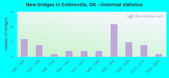
- New bridges - historical statistics
- 61930-1939
- 41940-1949
- 11950-1959
- 21960-1969
- 21970-1979
- 21980-1989
- 111990-1999
- 52000-2009
- 42010-2019
- 12020-2022


- Bridge Condition - Deck
- 4.8%Very good
- 61.9%Good
- 14.3%Satisfactory
- 9.5%Fair
- 4.8%Poor
- 4.8%Serious

- Bridge Condition - Superstructure
- 4.8%Excellent
- 28.6%Very good
- 28.6%Good
- 23.8%Satisfactory
- 4.8%Fair
- 9.5%Poor

- Bridge Condition - Substructure
- 9.5%Very good
- 23.8%Good
- 28.6%Satisfactory
- 28.6%Fair
- 4.8%Poor
- 4.8%Serious

- Bridge Condition - Channel
- 30.0%Very good
- 23.3%Good
- 20.0%Satisfactory
- 23.3%Fair
- 3.3%Poor

- Bridge Condition - Culverts
- 7.7%Excellent
- 15.4%Very good
- 61.5%Good
- 7.7%Fair
- 7.7%Serious
Find on map >> Show street view
Structure Number: 2953, Location: 146 ST. N .9MI E 129 E AV (Lat: 36.365508, Lng: -95.812278), Route carried "on" structure: County highway 7254C, Year Built: 1930, Status: Posted for load, Structure Length: 1.25m (4.10ft), Average Daily Traffic: 980 (year 2020), Truck Traffic: 10%, Average Future Daily Traffic: 1,568 (year 2040), Design Load: HS 20, Features Intersected: CREEK
Minimum Vertical Clearance: 30+ m (98+ ft), Kilometerpoint: 1.046, Lanes on structure: 2, Owner: County Highway Agency, Approaching Roadway Width: 5.9m (19.4ft), Material/Design: Steel, Design/Construction: Stringer/Multi-beam, Number Of Spans In Main Unit: 1, Length of Maximum Span: 11.5m (37.7ft), Curb-To-Curb Width: 6.2m (20.3ft), Out-to-Out Width: 7.1m (23.3ft)
Condition: Deck: Satisfactory, Superstructure: Satisfactory, Substructure: Satisfactory, Channel: Fair, Operating Rating: 37.2 metric tons, Method Used To Determine Operating Rating: Load Factor (LF), Inventory Rating: 21.8 metric tons, Method Used To Determine Inventory Rating: Load Factor (LF), Structural Evaluation: Somewhat better than minimum adequacy, Deck Geometry: High priority of corrective action, Waterway Adequacy: Somewhat better than minimum adequacy, Approach Roadway Alignment: Better than present minimum criteria, Bridge Posting: Required (Relationship of Operating Rating to Maximum Legal Load: 10.0 - 19.9% below), Length Of Structure Improvement: 3.88m (12.73ft), Designated Inspection Frequency: Every 24 months, Inspection Date: August 2021, Bridge Improvement Cost: $198,000, Roadway Improvement Cost: $109,000, Total Project Cost: $315,000 ( Estimate for 2015), Deck Structure Type: Concrete Cast-file-Place, Wearing Surface/Protective System: Wearing Surface: Bituminous
Find on map >> Show street view
Structure Number: 3233, Location: OLD US 169 2.7 MI N SH 20 (Lat: 36.395403, Lng: -95.804403), Route carried "on" structure: County highway E0430, Year Built: 1930, Status: Posted for load, Structure Length: 11.00m (36.09ft), Average Daily Traffic: 100 (year 2020), Truck Traffic: 16%, Average Future Daily Traffic: 160 (year 2040), Features Intersected: CANEY RIVER O'FLOW
Minimum Vertical Clearance: 30+ m (98+ ft), Kilometerpoint: 0.644, Lanes on structure: 2, Owner: County Highway Agency, Approaching Roadway Width: 7.3m (24.0ft), Material/Design: Steel, Design/Construction: Stringer/Multi-beam, Number Of Spans In Main Unit: 10, Length of Maximum Span: 11.4m (37.4ft), Curb-To-Curb Width: 6.7m (22.0ft), Out-to-Out Width: 7.6m (24.9ft)
Condition: Deck: Poor, Superstructure: Poor, Substructure: Fair, Channel: Good, Operating Rating: 17.2 metric tons, Method Used To Determine Operating Rating: Allowable Stress (AS), Inventory Rating: 10.0 metric tons, Method Used To Determine Inventory Rating: Allowable Stress (AS), Structural Evaluation: High priority of replacement, Deck Geometry: Somewhat better than minimum adequacy, Waterway Adequacy: Better than present minimum criteria, Approach Roadway Alignment: Equal to present desirable criteria, Bridge Posting: Required (Relationship of Operating Rating to Maximum Legal Load: > 39.9% below), Length Of Structure Improvement: 12.30m (40.35ft), Designated Inspection Frequency: Every 12 months, Inspection Date: August 2021, Bridge Improvement Cost: $628,000, Roadway Improvement Cost: $345,000, Total Project Cost: $985,000 ( Estimate for 2015), Deck Structure Type: Concrete Cast-file-Place, Wearing Surface/Protective System: Wearing Surface: Monolithic Concrete
Find on map >> Show street view
Structure Number: 3237, Location: OLD US 169 2.9MI N SH 20 (Lat: 36.395658, Lng: -95.799264), Route carried "on" structure: County highway 169, Year Built: 1930, Status: Posted for load, Structure Length: 13.53m (44.39ft), Average Daily Traffic: 400 (year 2020), Truck Traffic: 16%, Average Future Daily Traffic: 640 (year 2040), Design Load: H 20, Features Intersected: CREEK
Minimum Vertical Clearance: 30+ m (98+ ft), Kilometerpoint: 1.127, Lanes on structure: 2, Owner: County Highway Agency, Approaching Roadway Width: 7.5m (24.6ft), Material/Design: Steel, Design/Construction: Truss - Thru, Number Of Spans In Main Unit: 1, Number Of Approach Spans: 10, Length of Maximum Span: 24.4m (80.1ft), Curb or Sidewalk Widths: Left: 0.2m (0.7ft), Right: 0.2m (0.7ft), Curb-To-Curb Width: 6.7m (22.0ft), Out-to-Out Width: 7.0m (23.0ft)
Condition: Deck: Fair, Superstructure: Poor, Substructure: Fair, Channel: Satisfactory, Operating Rating: 23.5 metric tons, Method Used To Determine Operating Rating: Allowable Stress (AS), Inventory Rating: 13.2 metric tons, Method Used To Determine Inventory Rating: Allowable Stress (AS), Structural Evaluation: Meets minimum limits, Deck Geometry: Meets minimum limits, Waterway Adequacy: Better than present minimum criteria, Approach Roadway Alignment: Equal to present minimum criteria, Bridge Posting: Required (Relationship of Operating Rating to Maximum Legal Load: 20.0 - 29.9% below), Length Of Structure Improvement: 13.72m (45.01ft), Designated Inspection Frequency: Every 24 months, Critical Feature Inspection Frequency: Every 24 months, Other Special Inspection Frequency: Every 24 months, Inspection Date: July 2021, Critical Feature Inspection Date: July 2021, Other Special Inspection Date: July 2020, Bridge Improvement Cost: $701,000, Roadway Improvement Cost: $386,000, Total Project Cost: $1,101,000 ( Estimate for 2015), Deck Structure Type: Concrete Cast-file-Place, Wearing Surface/Protective System: Wearing Surface: Monolithic Concrete
Find on map >> Show street view
Structure Number: 521, Location: 186 ST. N. 1.2 E HWY 75 (Lat: 36.423681, Lng: -95.899325), Route carried "on" structure: County highway E0410, Year Built: 1937, Status: Open, Structure Length: 0.70m (2.30ft), Average Daily Traffic: 100 (year 2020), Truck Traffic: 10%, Average Future Daily Traffic: 160 (year 2040), Design Load: HS 20, Features Intersected: CREEK
Minimum Vertical Clearance: 30+ m (98+ ft), Kilometerpoint: 0.322, Lanes on structure: 2, Owner: County Highway Agency, Approaching Roadway Width: 5.8m (19.0ft), Material/Design: Concrete, Design/Construction: Culvert, Number Of Spans In Main Unit: 2, Length of Maximum Span: 3.0m (9.8ft), Out-to-Out Width: 8.6m (28.2ft)
Condition: Channel: Fair, Culverts: Fair, Operating Rating: 44.5 metric tons, Method Used To Determine Operating Rating: Allowable Stress (AS), Inventory Rating: 32.7 metric tons, Method Used To Determine Inventory Rating: Allowable Stress (AS), Structural Evaluation: Somewhat better than minimum adequacy, Waterway Adequacy: Somewhat better than minimum adequacy, Approach Roadway Alignment: Better than present minimum criteria, Length Of Structure Improvement: 2.86m (9.38ft), Designated Inspection Frequency: Every 24 months, Inspection Date: August 2021, Bridge Improvement Cost: $100,000, Roadway Improvement Cost: $75,000, Total Project Cost: $225,000 ( Estimate for 2015), Deck Structure Type: Concrete Cast-file-Place
Find on map >> Show street view
Structure Number: 5378, Location: .1S OF SH 20 (Lat: 36.362431, Lng: -95.830250), Route carried "on" structure: City street N4030, Year Built: 1940, Status: Open, Structure Length: 1.22m (4.00ft), Average Daily Traffic: 2,560 (year 2020), Truck Traffic: 10%, Average Future Daily Traffic: 4,096 (year 2040), Design Load: HS 20, Features Intersected: CREEK
Minimum Vertical Clearance: 30+ m (98+ ft), Kilometerpoint: 0.322, Lanes on structure: 2, Owner: City or Municipal Highway Agency, Maintenance Responsibility: County Highway Agency, Approaching Roadway Width: 7.3m (24.0ft), Skew: 3 degrees, Material/Design: Concrete, Design/Construction: Culvert, Number Of Spans In Main Unit: 3, Length of Maximum Span: 4.3m (14.1ft), Curb-To-Curb Width: 9.4m (30.8ft), Out-to-Out Width: 10.0m (32.8ft)
Condition: Channel: Fair, Culverts: Serious, Operating Rating: 44.5 metric tons, Method Used To Determine Operating Rating: Allowable Stress (AS), Inventory Rating: 32.7 metric tons, Method Used To Determine Inventory Rating: Allowable Stress (AS), Structural Evaluation: High priority of corrective action, Deck Geometry: Meets minimum limits, Waterway Adequacy: Somewhat better than minimum adequacy, Approach Roadway Alignment: Better than present minimum criteria, Length Of Structure Improvement: 3.93m (12.89ft), Designated Inspection Frequency: Every 24 months, Inspection Date: August 2021, Bridge Improvement Cost: $100,000, Roadway Improvement Cost: $75,000, Total Project Cost: $225,000 ( Estimate for 2015), Deck Structure Type: Concrete Cast-file-Place, Wearing Surface/Protective System: Wearing Surface: Bituminous
Find on map >> Show street view
Structure Number: 7069, Location: 166ST N .4 MI.E MEMORIAL (Lat: 36.394636, Lng: -95.878508), Route carried "on" structure: County highway E0430, Year Built: 1939, Status: Open, Structure Length: 0.94m (3.08ft), Average Daily Traffic: 287 (year 2020), Truck Traffic: 10%, Average Future Daily Traffic: 459 (year 2040), Design Load: HS 20, Features Intersected: CREEK
Minimum Vertical Clearance: 30+ m (98+ ft), Kilometerpoint: 0.644, Lanes on structure: 2, Owner: County Highway Agency, Approaching Roadway Width: 5.5m (18.0ft), Skew: 3 degrees, Material/Design: Concrete, Design/Construction: Culvert, Number Of Spans In Main Unit: 2, Length of Maximum Span: 4.3m (14.1ft)
Condition: Channel: Fair, Culverts: Good, Operating Rating: 44.5 metric tons, Method Used To Determine Operating Rating: Allowable Stress (AS), Inventory Rating: 32.7 metric tons, Method Used To Determine Inventory Rating: Allowable Stress (AS), Structural Evaluation: Better than present minimum criteria, Waterway Adequacy: Somewhat better than minimum adequacy, Approach Roadway Alignment: Better than present minimum criteria, Length Of Structure Improvement: 3.34m (10.96ft), Designated Inspection Frequency: Every 24 months, Inspection Date: August 2021, Bridge Improvement Cost: $100,000, Roadway Improvement Cost: $75,000, Total Project Cost: $225,000 ( Estimate for 2015), Deck Structure Type: Concrete Cast-file-Place
Find on map >> Show street view
Structure Number: 7399, Location: SHERIDAN .9 S. 166 ST N (Lat: 36.382056, Lng: -95.902181), Route carried "on" structure: County highway N3990, Year Built: 1940, Status: Posted for load, Structure Length: 0.70m (2.30ft), Average Daily Traffic: 100 (year 2020), Truck Traffic: 10%, Average Future Daily Traffic: 160 (year 2040), Design Load: HS 20, Features Intersected: CREEK
Minimum Vertical Clearance: 30+ m (98+ ft), Kilometerpoint: 1.448, Lanes on structure: 1, Owner: County Highway Agency, Approaching Roadway Width: 4.1m (13.5ft), Material/Design: Steel, Design/Construction: Stringer/Multi-beam, Number Of Spans In Main Unit: 1, Length of Maximum Span: 7.0m (23.0ft), Curb-To-Curb Width: 4.6m (15.1ft), Out-to-Out Width: 4.9m (16.1ft)
Condition: Deck: Serious, Superstructure: Fair, Substructure: Serious, Channel: Poor, Operating Rating: 40.8 metric tons, Method Used To Determine Operating Rating: Load Factor (LF), Inventory Rating: 24.5 metric tons, Method Used To Determine Inventory Rating: Load Factor (LF), Structural Evaluation: High priority of corrective action, Deck Geometry: Better than present minimum criteria, Waterway Adequacy: Somewhat better than minimum adequacy, Approach Roadway Alignment: Somewhat better than minimum adequacy, Bridge Posting: Required (Relationship of Operating Rating to Maximum Legal Load: 10.0 - 19.9% below), Length Of Structure Improvement: 2.86m (9.38ft), Designated Inspection Frequency: Every 12 months, Inspection Date: August 2021, Bridge Improvement Cost: $80,000, Roadway Improvement Cost: $40,000, Total Project Cost: $225,000 ( Estimate for 2015), Deck Structure Type: Concrete Cast-file-Place, Wearing Surface/Protective System: Wearing Surface: Bituminous
Find on map >> Show street view
Structure Number: 8078, Location: 136 ST N .7MI E SHERIDAN (Lat: 36.351114, Lng: -95.890753), Route carried "on" structure: County highway E0460, Year Built: 1940, Status: Posted for load, Structure Length: 0.76m (2.49ft), Average Daily Traffic: 100 (year 2020), Truck Traffic: 10%, Average Future Daily Traffic: 160 (year 2040), Design Load: HS 20, Features Intersected: CHERRY CREEK
Minimum Vertical Clearance: 30+ m (98+ ft), Kilometerpoint: 1.127, Lanes on structure: 2, Owner: County Highway Agency, Approaching Roadway Width: 4.0m (13.1ft), Material/Design: Steel, Design/Construction: Stringer/Multi-beam, Number Of Spans In Main Unit: 1, Length of Maximum Span: 7.3m (24.0ft), Curb-To-Curb Width: 5.4m (17.7ft), Out-to-Out Width: 6.3m (20.7ft)
Condition: Deck: Satisfactory, Superstructure: Satisfactory, Substructure: Fair, Channel: Fair, Operating Rating: 36.3 metric tons, Method Used To Determine Operating Rating: Load Factor (LF), Inventory Rating: 21.8 metric tons, Method Used To Determine Inventory Rating: Load Factor (LF), Structural Evaluation: Somewhat better than minimum adequacy, Deck Geometry: High priority of corrective action, Waterway Adequacy: Somewhat better than minimum adequacy, Approach Roadway Alignment: Equal to present minimum criteria, Bridge Posting: Required (Relationship of Operating Rating to Maximum Legal Load: 30.0 - 39.9% below), Length Of Structure Improvement: 2.98m (9.78ft), Designated Inspection Frequency: Every 24 months, Inspection Date: August 2021, Bridge Improvement Cost: $152,000, Roadway Improvement Cost: $84,000, Total Project Cost: $241,000 ( Estimate for 2015), Deck Structure Type: Concrete Cast-file-Place, Wearing Surface/Protective System: Wearing Surface: Bituminous
Find on map >> Show street view
Structure Number: 8667, Location: 156 ST N .2MI E SHERIDAN (Lat: 36.380158, Lng: -95.898806), Route carried "on" structure: County highway E0440, Year Built: 1940, Status: Posted for load, Structure Length: 0.94m (3.08ft), Average Daily Traffic: 100 (year 2020), Truck Traffic: 10%, Average Future Daily Traffic: 160 (year 2040), Features Intersected: HORSEPEN CREEK
Minimum Vertical Clearance: 30+ m (98+ ft), Kilometerpoint: 0.322, Lanes on structure: 1, Owner: County Highway Agency, Approaching Roadway Width: 4.0m (13.1ft), Material/Design: Steel, Design/Construction: Girder and Floorbeam System, Number Of Spans In Main Unit: 1, Length of Maximum Span: 8.5m (27.9ft), Curb-To-Curb Width: 3.8m (12.5ft), Out-to-Out Width: 4.3m (14.1ft)
Condition: Deck: Fair, Superstructure: Satisfactory, Substructure: Poor, Channel: Satisfactory, Operating Rating: 9.1 metric tons, Method Used To Determine Operating Rating: Load Factor (LF), Inventory Rating: 5.4 metric tons, Method Used To Determine Inventory Rating: Load Factor (LF), Structural Evaluation: High priority of replacement, Deck Geometry: Meets minimum limits, Waterway Adequacy: Somewhat better than minimum adequacy, Approach Roadway Alignment: Equal to present minimum criteria, Bridge Posting: Required (Relationship of Operating Rating to Maximum Legal Load: > 39.9% below), Length Of Structure Improvement: 3.34m (10.96ft), Designated Inspection Frequency: Every 24 months, Critical Feature Inspection Frequency: Every 24 months, Inspection Date: July 2021, Critical Feature Inspection Date: July 2021, Bridge Improvement Cost: $85,000, Roadway Improvement Cost: $47,000, Total Project Cost: $225,000 ( Estimate for 2015), Deck Structure Type: Concrete Cast-file-Place, Wearing Surface/Protective System: Wearing Surface: Bituminous
Find on map >> Show street view
Structure Number: 13513, Location: 129 E AVE. .4MI S 166 N. (Lat: 36.388356, Lng: -95.830194), Route carried "on" structure: County highway N4030, Year Built: 1955, Status: Open, Structure Length: 4.69m (15.39ft), Average Daily Traffic: 718 (year 2020), Truck Traffic: 10%, Average Future Daily Traffic: 1,149 (year 2040), Design Load: HS 20, Features Intersected: CREEK
Minimum Vertical Clearance: 30+ m (98+ ft), Kilometerpoint: 0.644, Lanes on structure: 2, Owner: County Highway Agency, Approaching Roadway Width: 6.9m (22.6ft), Skew: 3 degrees, Material/Design: Prestressed concrete, Design/Construction: Stringer/Multi-beam, Number Of Spans In Main Unit: 3, Length of Maximum Span: 15.2m (49.9ft), Curb-To-Curb Width: 9.4m (30.8ft), Out-to-Out Width: 10.2m (33.5ft)
Condition: Deck: Good, Superstructure: Good, Substructure: Satisfactory, Channel: Satisfactory, Operating Rating: 44.5 metric tons, Method Used To Determine Operating Rating: Allowable Stress (AS), Inventory Rating: 32.7 metric tons, Method Used To Determine Inventory Rating: Allowable Stress (AS), Structural Evaluation: Equal to present minimum criteria, Deck Geometry: Equal to present minimum criteria, Waterway Adequacy: Somewhat better than minimum adequacy, Approach Roadway Alignment: Better than present minimum criteria, Length Of Structure Improvement: 7.83m (25.69ft), Designated Inspection Frequency: Every 24 months, Inspection Date: August 2021, Bridge Improvement Cost: $400,000, Roadway Improvement Cost: $220,000, Total Project Cost: $682,000 ( Estimate for 2015), Deck Structure Type: Concrete Cast-file-Place, Wearing Surface/Protective System: Wearing Surface: Monolithic Concrete
Find on map >> Show street view
Structure Number: 15674, Location: 2.4 MI N JCT SH 20 (Lat: 36.399897, Lng: -95.920181), Route carried "on" structure: US 75, Year Built: 1963, Year Reconstructed: 1986, Status: Open, Structure Length: 0.98m (3.22ft), Average Daily Traffic: 13,800 (year 2020), Truck Traffic: 8%, Average Future Daily Traffic: 22,080 (year 2040), Design Load: HL 93, Features Intersected: CREEK
Minimum Vertical Clearance: 30+ m (98+ ft), Kilometerpoint: 28.592, Lanes on structure: 4, Base Highway Network: Yes, Owner: State Highway Agency, Approaching Roadway Width: 11.6m (38.1ft), Skew: 4 degrees, Material/Design: Concrete, Design/Construction: Culvert, Number Of Spans In Main Unit: 2, Length of Maximum Span: 3.0m (9.8ft)
Condition: Channel: Satisfactory, Culverts: Good, Operating Rating: 53.1 metric tons, Method Used To Determine Operating Rating: Load Factor (LF), Inventory Rating: 40.9 metric tons, Method Used To Determine Inventory Rating: Load Factor (LF), Structural Evaluation: Better than present minimum criteria, Waterway Adequacy: Better than present minimum criteria, Approach Roadway Alignment: Equal to present desirable criteria, Length Of Structure Improvement: 0.98m (3.22ft), Designated Inspection Frequency: Every 24 months, Inspection Date: December 2020, Bridge Improvement Cost: $280,000, Roadway Improvement Cost: $462,000, Total Project Cost: $783,000 ( Estimate for 2015)
Find on map >> Show street view
Structure Number: 17058, Location: 129 E AVE .7MI S 156 ST N (Lat: 36.370650, Lng: -95.830194), Route carried "on" structure: County highway N4030, Year Built: 1968, Status: Posted for load, Structure Length: 0.91m (2.99ft), Average Daily Traffic: 1,880 (year 2020), Truck Traffic: 10%, Average Future Daily Traffic: 3,008 (year 2040), Design Load: HS 20, Features Intersected: BLACKJACK CREEK TRIB.
Minimum Vertical Clearance: 30+ m (98+ ft), Kilometerpoint: 1.127, Lanes on structure: 2, Owner: County Highway Agency, Approaching Roadway Width: 6.7m (22.0ft), Material/Design: Steel, Design/Construction: Stringer/Multi-beam, Number Of Spans In Main Unit: 1, Length of Maximum Span: 7.9m (25.9ft), Curb-To-Curb Width: 9.8m (32.2ft), Out-to-Out Width: 10.5m (34.4ft)
Condition: Deck: Satisfactory, Superstructure: Satisfactory, Substructure: Fair, Channel: Fair, Operating Rating: 29.0 metric tons, Method Used To Determine Operating Rating: Load Factor (LF), Inventory Rating: 17.2 metric tons, Method Used To Determine Inventory Rating: Load Factor (LF), Structural Evaluation: Meets minimum limits, Deck Geometry: Somewhat better than minimum adequacy, Waterway Adequacy: Meets minimum limits, Approach Roadway Alignment: Better than present minimum criteria, Bridge Posting: Required (Relationship of Operating Rating to Maximum Legal Load: 0.1 - 9.9% below), Length Of Structure Improvement: 3.22m (10.56ft), Designated Inspection Frequency: Every 24 months, Inspection Date: August 2021, Bridge Improvement Cost: $165,000, Roadway Improvement Cost: $91,000, Total Project Cost: $261,000 ( Estimate for 2015), Deck Structure Type: Concrete Cast-file-Place, Wearing Surface/Protective System: Wearing Surface: Bituminous
Find on map >> Show street view
Structure Number: 18077, Location: JCT SH 20 (Lat: 36.365436, Lng: -95.920514), Route carried "on" structure: US 75, Year Built: 1971, Status: Open, Structure Length: 5.07m (16.63ft), Average Daily Traffic: 11,250 (year 2020), Truck Traffic: 8%, Average Future Daily Traffic: 18,000 (year 2040), Design Load: HS 20, Features Intersected: S.H. 20 UNDER
Minimum Vertical Clearance: 30+ m (98+ ft), Kilometerpoint: 24.745, Lanes on structure: 2, Lanes under structure: 4, Base Highway Network: Yes, Owner: State Highway Agency, Approaching Roadway Width: 12.2m (40.0ft), Skew: 10 degrees, Material/Design: Prestressed concrete, Design/Construction: Stringer/Multi-beam, Number Of Spans In Main Unit: 2, Length of Maximum Span: 25.9m (85.0ft), Curb-To-Curb Width: 12.4m (40.7ft), Out-to-Out Width: 13.3m (43.6ft)
Condition: Deck: Very good, Superstructure: Excellent, Substructure: Good, Operating Rating: 41.4 metric tons, Method Used To Determine Operating Rating: Load Factor (LF), Inventory Rating: 31.0 metric tons, Method Used To Determine Inventory Rating: Load Factor (LF), Structural Evaluation: Better than present minimum criteria, Deck Geometry: Better than present minimum criteria, Underclear: Somewhat better than minimum adequacy, Approach Roadway Alignment: Equal to present desirable criteria, Length Of Structure Improvement: 8.40m (27.56ft), Designated Inspection Frequency: Every 24 months, Inspection Date: December 2020, Bridge Improvement Cost: $1,078,000, Roadway Improvement Cost: $1,778,000, Total Project Cost: $3,017,000 ( Estimate for 2015), Deck Structure Type: Concrete Cast-file-Place, Wearing Surface/Protective System: Wearing Surface: Monolithic Concrete, Membrane: Epoxy, Deck Protection: Epoxy Coated Reinforcing
Find on map >> Show street view
Structure Number: 18918, Location: 136 ST N .8MI E GARNETT (Lat: 36.351036, Lng: -95.833658), Route carried "on" structure: County highway E0460, Year Built: 1936, Status: Posted for load, Structure Length: 1.04m (3.41ft), Average Daily Traffic: 315 (year 2020), Truck Traffic: 10%, Average Future Daily Traffic: 504 (year 2040), Design Load: HS 20, Features Intersected: CREEK
Minimum Vertical Clearance: 30+ m (98+ ft), Kilometerpoint: 1.287, Lanes on structure: 2, Owner: County Highway Agency, Approaching Roadway Width: 6.2m (20.3ft), Material/Design: Steel continuous, Design/Construction: Stringer/Multi-beam, Number Of Spans In Main Unit: 2, Length of Maximum Span: 4.7m (15.4ft), Curb-To-Curb Width: 7.3m (24.0ft), Out-to-Out Width: 7.9m (25.9ft)
Condition: Deck: Good, Superstructure: Satisfactory, Substructure: Fair, Channel: Fair, Operating Rating: 27.2 metric tons, Method Used To Determine Operating Rating: Load Factor (LF), Inventory Rating: 16.3 metric tons, Method Used To Determine Inventory Rating: Load Factor (LF), Structural Evaluation: Somewhat better than minimum adequacy, Deck Geometry: Somewhat better than minimum adequacy, Waterway Adequacy: Meets minimum limits, Approach Roadway Alignment: Better than present minimum criteria, Bridge Posting: Required (Relationship of Operating Rating to Maximum Legal Load: 20.0 - 29.9% below), Length Of Structure Improvement: 3.52m (11.55ft), Designated Inspection Frequency: Every 24 months, Inspection Date: August 2021, Bridge Improvement Cost: $180,000, Roadway Improvement Cost: $99,000, Total Project Cost: $285,000 ( Estimate for 2015), Deck Structure Type: Concrete Cast-file-Place, Wearing Surface/Protective System: Wearing Surface: Bituminous
Find on map >> Show street view
Structure Number: 22071, Location: 15.3 MI N OF I-44 (Lat: 36.350833, Lng: -95.820833), Route carried "on" structure: City street , Year Built: 1988, Status: Open, Structure Length: 7.13m (23.39ft), Average Daily Traffic: 1,000 (year 2020), Truck Traffic: 15%, Average Future Daily Traffic: 1,600 (year 2040), Design Load: HS 20, Features Intersected: U.S. 169 UNDER, Facility Carried by Structure: E. 136 ST. N
Minimum Vertical Clearance: 30+ m (98+ ft), Kilometerpoint: 24.731, Lanes on structure: 2, Lanes under structure: 6, Owner: State Highway Agency, Approaching Roadway Width: 11.0m (36.1ft), Material/Design: Steel continuous, Design/Construction: Stringer/Multi-beam, Number Of Spans In Main Unit: 2, Length of Maximum Span: 35.4m (116.1ft), Curb-To-Curb Width: 11.0m (36.1ft), Out-to-Out Width: 11.9m (39.0ft)
Condition: Deck: Good, Superstructure: Very good, Substructure: Good, Operating Rating: 62.3 metric tons, Method Used To Determine Operating Rating: Load Factor (LF), Inventory Rating: 37.3 metric tons, Method Used To Determine Inventory Rating: Load Factor (LF), Structural Evaluation: Better than present minimum criteria, Deck Geometry: Better than present minimum criteria, Underclear: Meets minimum limits, Approach Roadway Alignment: Equal to present desirable criteria, Length Of Structure Improvement: 7.20m (23.62ft), Designated Inspection Frequency: Every 24 months, Inspection Date: November 2020, Bridge Improvement Cost: $603,000, Roadway Improvement Cost: $995,000, Total Project Cost: $1,689,000 ( Estimate for 2015), Deck Structure Type: Concrete Cast-file-Place, Wearing Surface/Protective System: Wearing Surface: Monolithic Concrete, Membrane: Epoxy, Deck Protection: Epoxy Coated Reinforcing
Find on map >> Show street view
Structure Number: 22651, Location: 16.3 MI N OF I-44 (Lat: 36.365317, Lng: -95.822381), Route carried "on" structure: US 169, Year Built: 1990, Status: Open, Structure Length: 3.11m (10.20ft), Average Daily Traffic: 7,500 (year 2020), Truck Traffic: 8%, Average Future Daily Traffic: 12,000 (year 2040), Design Load: HS 20, Features Intersected: S.H. 20 UNDER
Minimum Vertical Clearance: 30+ m (98+ ft), Kilometerpoint: 26.339, Lanes on structure: 2, Lanes under structure: 2, Base Highway Network: Yes, Owner: State Highway Agency, Approaching Roadway Width: 11.6m (38.1ft), Skew: 10 degrees, Material/Design: Prestressed concrete, Design/Construction: Stringer/Multi-beam, Number Of Spans In Main Unit: 1, Length of Maximum Span: 30.5m (100.1ft), Curb-To-Curb Width: 12.2m (40.0ft), Out-to-Out Width: 13.1m (43.0ft)
Condition: Deck: Good, Superstructure: Very good, Substructure: Good, Operating Rating: 54.2 metric tons, Method Used To Determine Operating Rating: Load and Resistance Factor (LRFR), Inventory Rating: 33.2 metric tons, Method Used To Determine Inventory Rating: Load and Resistance Factor (LRFR), Structural Evaluation: Better than present minimum criteria, Deck Geometry: Better than present minimum criteria, Underclear: Equal to present minimum criteria, Approach Roadway Alignment: Equal to present desirable criteria, Length Of Structure Improvement: 8.40m (27.56ft), Designated Inspection Frequency: Every 24 months, Inspection Date: November 2020, Bridge Improvement Cost: $1,078,000, Roadway Improvement Cost: $1,778,000, Total Project Cost: $3,017,000 ( Estimate for 2015), Deck Structure Type: Concrete Cast-file-Place, Wearing Surface/Protective System: Wearing Surface: Monolithic Concrete, Membrane: Epoxy, Deck Protection: Epoxy Coated Reinforcing
Find on map >> Show street view
Structure Number: 22652, Location: 16.3 MI N OF I-44 (Lat: 36.365317, Lng: -95.821922), Route carried "on" structure: US 169, Year Built: 1990, Status: Open, Structure Length: 3.11m (10.20ft), Average Daily Traffic: 7,100 (year 2020), Truck Traffic: 8%, Average Future Daily Traffic: 11,360 (year 2040), Design Load: HS 20, Features Intersected: S.H. 20 UNDER
Minimum Vertical Clearance: 30+ m (98+ ft), Kilometerpoint: 26.339, Lanes on structure: 2, Lanes under structure: 2, Base Highway Network: Yes, Owner: State Highway Agency, Approaching Roadway Width: 11.6m (38.1ft), Skew: 10 degrees, Material/Design: Prestressed concrete, Design/Construction: Stringer/Multi-beam, Number Of Spans In Main Unit: 1, Length of Maximum Span: 30.5m (100.1ft), Curb-To-Curb Width: 12.2m (40.0ft), Out-to-Out Width: 13.1m (43.0ft)
Condition: Deck: Good, Superstructure: Very good, Substructure: Very good, Operating Rating: 54.2 metric tons, Method Used To Determine Operating Rating: Load and Resistance Factor (LRFR), Inventory Rating: 33.2 metric tons, Method Used To Determine Inventory Rating: Load and Resistance Factor (LRFR), Structural Evaluation: Equal to present desirable criteria, Deck Geometry: Better than present minimum criteria, Underclear: Equal to present minimum criteria, Approach Roadway Alignment: Equal to present desirable criteria, Length Of Structure Improvement: 8.40m (27.56ft), Designated Inspection Frequency: Every 24 months, Inspection Date: November 2020, Bridge Improvement Cost: $1,078,000, Roadway Improvement Cost: $1,778,000, Total Project Cost: $3,017,000 ( Estimate for 2015), Deck Structure Type: Concrete Cast-file-Place, Wearing Surface/Protective System: Wearing Surface: Monolithic Concrete, Membrane: Epoxy, Deck Protection: Epoxy Coated Reinforcing
Find on map >> Show street view
Structure Number: 24672, Location: 129E.AVE.;.4M S. 146ST. N (Lat: 36.358036, Lng: -95.830153), Route carried "on" structure: County highway N4030, Year Built: 1996, Status: Open, Structure Length: 1.62m (5.31ft), Average Daily Traffic: 836 (year 2020), Truck Traffic: 10%, Average Future Daily Traffic: 1,338 (year 2040), Design Load: HS 20, Features Intersected: BLACKJACK CREEK
Minimum Vertical Clearance: 30+ m (98+ ft), Kilometerpoint: 0.644, Lanes on structure: 2, Owner: County Highway Agency, Approaching Roadway Width: 10.4m (34.1ft), Skew: 6 degrees, Material/Design: Concrete, Design/Construction: Culvert, Number Of Spans In Main Unit: 3, Length of Maximum Span: 6.1m (20.0ft), Curb-To-Curb Width: 10.4m (34.1ft), Out-to-Out Width: 12.2m (40.0ft)
Condition: Channel: Satisfactory, Culverts: Good, Operating Rating: 42.6 metric tons, Method Used To Determine Operating Rating: Load Factor (LF), Inventory Rating: 32.7 metric tons, Method Used To Determine Inventory Rating: Load Factor (LF), Structural Evaluation: Better than present minimum criteria, Deck Geometry: Equal to present minimum criteria, Waterway Adequacy: Equal to present minimum criteria, Approach Roadway Alignment: Equal to present minimum criteria, Length Of Structure Improvement: 4.35m (14.27ft), Designated Inspection Frequency: Every 24 months, Inspection Date: August 2021, Bridge Improvement Cost: $100,000, Roadway Improvement Cost: $75,000, Total Project Cost: $225,000 ( Estimate for 2015)
Find on map >> Show street view
Structure Number: 25246, Location: 1.5 MI N JCT SH 20 (Lat: 36.387989, Lng: -95.805350), Route carried "on" structure: US 169, Year Built: 1997, Status: Open, Structure Length: 21.40m (70.21ft), Average Daily Traffic: 4,950 (year 2020), Truck Traffic: 25%, Average Future Daily Traffic: 7,920 (year 2040), Design Load: HS 20, Features Intersected: CANEY RIVER
Minimum Vertical Clearance: 30+ m (98+ ft), Kilometerpoint: 0.950, Lanes on structure: 2, Base Highway Network: Yes, Owner: State Highway Agency, Approaching Roadway Width: 11.6m (38.1ft), Skew: 10 degrees, Material/Design: Prestressed concrete, Design/Construction: Stringer/Multi-beam, Number Of Spans In Main Unit: 7, Length of Maximum Span: 30.5m (100.1ft), Curb-To-Curb Width: 11.6m (38.1ft), Out-to-Out Width: 12.5m (41.0ft)
Condition: Deck: Good, Superstructure: Very good, Substructure: Satisfactory, Channel: Good, Operating Rating: 87.2 metric tons, Method Used To Determine Operating Rating: Load Factor (LF), Inventory Rating: 37.6 metric tons, Method Used To Determine Inventory Rating: Load Factor (LF), Structural Evaluation: Equal to present minimum criteria, Deck Geometry: Better than present minimum criteria, Waterway Adequacy: Equal to present desirable criteria, Approach Roadway Alignment: Equal to present desirable criteria, Length Of Structure Improvement: 21.40m (70.21ft), Designated Inspection Frequency: Every 24 months, Inspection Date: May 2020, Bridge Improvement Cost: $1,540,000, Roadway Improvement Cost: $2,540,000, Total Project Cost: $4,311,000 ( Estimate for 2015), Deck Structure Type: Concrete Cast-file-Place, Wearing Surface/Protective System: Wearing Surface: Monolithic Concrete, Membrane: Epoxy, Deck Protection: Epoxy Coated Reinforcing
Find on map >> Show street view
Structure Number: 25248, Location: 1.7 MI N JCT SH 20 (Lat: 36.391314, Lng: -95.801825), Route carried "on" structure: US 169, Year Built: 1997, Status: Open, Structure Length: 13.78m (45.21ft), Average Daily Traffic: 4,950 (year 2020), Truck Traffic: 25%, Average Future Daily Traffic: 7,920 (year 2040), Design Load: HS 20, Features Intersected: CANEY RIVER O'FLOW
Minimum Vertical Clearance: 30+ m (98+ ft), Kilometerpoint: 1.448, Lanes on structure: 2, Base Highway Network: Yes, Owner: State Highway Agency, Approaching Roadway Width: 11.6m (38.1ft), Skew: 10 degrees, Material/Design: Prestressed concrete, Design/Construction: Stringer/Multi-beam, Number Of Spans In Main Unit: 9, Length of Maximum Span: 15.2m (49.9ft), Curb-To-Curb Width: 11.6m (38.1ft), Out-to-Out Width: 12.5m (41.0ft)
Condition: Deck: Good, Superstructure: Good, Substructure: Good, Channel: Very good, Operating Rating: 62.8 metric tons, Method Used To Determine Operating Rating: Load Factor (LF), Inventory Rating: 37.6 metric tons, Method Used To Determine Inventory Rating: Load Factor (LF), Structural Evaluation: Better than present minimum criteria, Deck Geometry: Better than present minimum criteria, Waterway Adequacy: Equal to present desirable criteria, Approach Roadway Alignment: Equal to present desirable criteria, Length Of Structure Improvement: 13.86m (45.47ft), Designated Inspection Frequency: Every 24 months, Inspection Date: May 2020, Bridge Improvement Cost: $1,060,000, Roadway Improvement Cost: $1,748,000, Total Project Cost: $2,967,000 ( Estimate for 2015), Deck Structure Type: Concrete Cast-file-Place, Wearing Surface/Protective System: Wearing Surface: Monolithic Concrete, Membrane: Epoxy, Deck Protection: Epoxy Coated Reinforcing
Find on map >> Show street view
Structure Number: 25249, Location: 2.1 MI N. JCT. SH-20 (Lat: 36.393006, Lng: -95.799492), Route carried "on" structure: US 169, Year Built: 1997, Status: Open, Structure Length: 13.78m (45.21ft), Average Daily Traffic: 4,950 (year 2020), Truck Traffic: 25%, Average Future Daily Traffic: 7,920 (year 2040), Design Load: HS 20, Features Intersected: FOUR MILE CREEK
Minimum Vertical Clearance: 30+ m (98+ ft), Kilometerpoint: 1.722, Lanes on structure: 2, Base Highway Network: Yes, Owner: State Highway Agency, Approaching Roadway Width: 11.6m (38.1ft), Skew: 10 degrees, Material/Design: Prestressed concrete, Design/Construction: Stringer/Multi-beam, Number Of Spans In Main Unit: 9, Length of Maximum Span: 15.2m (49.9ft), Curb-To-Curb Width: 11.6m (38.1ft), Out-to-Out Width: 12.5m (41.0ft)
Condition: Deck: Good, Superstructure: Good, Substructure: Satisfactory, Channel: Very good, Operating Rating: 62.8 metric tons, Method Used To Determine Operating Rating: Load Factor (LF), Inventory Rating: 37.6 metric tons, Method Used To Determine Inventory Rating: Load Factor (LF), Structural Evaluation: Equal to present minimum criteria, Deck Geometry: Better than present minimum criteria, Waterway Adequacy: Equal to present desirable criteria, Approach Roadway Alignment: Equal to present desirable criteria, Length Of Structure Improvement: 13.86m (45.47ft), Designated Inspection Frequency: Every 24 months, Inspection Date: May 2020, Bridge Improvement Cost: $1,060,000, Roadway Improvement Cost: $1,748,000, Total Project Cost: $2,967,000 ( Estimate for 2015), Deck Structure Type: Concrete Cast-file-Place, Wearing Surface/Protective System: Wearing Surface: Monolithic Concrete, Membrane: Epoxy, Deck Protection: Epoxy Coated Reinforcing
Find on map >> Show street view
Structure Number: 2525, Location: 1.5 MI N JCT SH 20 (Lat: 36.388214, Lng: -95.805700), Route carried "on" structure: US 169, Year Built: 1997, Status: Open, Structure Length: 21.40m (70.21ft), Average Daily Traffic: 4,950 (year 2020), Truck Traffic: 25%, Average Future Daily Traffic: 7,920 (year 2040), Design Load: HS 20, Features Intersected: CANEY RIVER
Minimum Vertical Clearance: 30+ m (98+ ft), Kilometerpoint: 0.950, Lanes on structure: 2, Base Highway Network: Yes, Owner: State Highway Agency, Approaching Roadway Width: 11.6m (38.1ft), Skew: 10 degrees, Material/Design: Prestressed concrete, Design/Construction: Stringer/Multi-beam, Number Of Spans In Main Unit: 7, Length of Maximum Span: 30.5m (100.1ft), Curb-To-Curb Width: 11.6m (38.1ft), Out-to-Out Width: 12.5m (41.0ft)
Condition: Deck: Good, Superstructure: Very good, Substructure: Satisfactory, Channel: Good, Operating Rating: 87.2 metric tons, Method Used To Determine Operating Rating: Load Factor (LF), Inventory Rating: 37.6 metric tons, Method Used To Determine Inventory Rating: Load Factor (LF), Structural Evaluation: Equal to present minimum criteria, Deck Geometry: Better than present minimum criteria, Waterway Adequacy: Equal to present desirable criteria, Approach Roadway Alignment: Equal to present desirable criteria, Length Of Structure Improvement: 21.40m (70.21ft), Designated Inspection Frequency: Every 24 months, Inspection Date: May 2020, Bridge Improvement Cost: $1,540,000, Roadway Improvement Cost: $2,540,000, Total Project Cost: $4,311,000 ( Estimate for 2015), Deck Structure Type: Concrete Cast-file-Place, Wearing Surface/Protective System: Wearing Surface: Monolithic Concrete, Membrane: Epoxy, Deck Protection: Epoxy Coated Reinforcing
Find on map >> Show street view
Structure Number: 25251, Location: 1.7 MI N JCT SH 20 (Lat: 36.391578, Lng: -95.802133), Route carried "on" structure: US 169, Year Built: 1997, Status: Open, Structure Length: 13.78m (45.21ft), Average Daily Traffic: 4,950 (year 2020), Truck Traffic: 25%, Average Future Daily Traffic: 7,920 (year 2040), Design Load: HS 20, Features Intersected: CANEY RIVER O'FLOW
Minimum Vertical Clearance: 30+ m (98+ ft), Kilometerpoint: 1.448, Lanes on structure: 2, Base Highway Network: Yes, Owner: State Highway Agency, Approaching Roadway Width: 11.6m (38.1ft), Skew: 10 degrees, Material/Design: Prestressed concrete, Design/Construction: Stringer/Multi-beam, Number Of Spans In Main Unit: 9, Length of Maximum Span: 15.2m (49.9ft), Curb-To-Curb Width: 11.6m (38.1ft), Out-to-Out Width: 12.5m (41.0ft)
Condition: Deck: Good, Superstructure: Good, Substructure: Good, Channel: Very good, Operating Rating: 62.8 metric tons, Method Used To Determine Operating Rating: Load Factor (LF), Inventory Rating: 37.6 metric tons, Method Used To Determine Inventory Rating: Load Factor (LF), Structural Evaluation: Better than present minimum criteria, Deck Geometry: Better than present minimum criteria, Waterway Adequacy: Equal to present desirable criteria, Approach Roadway Alignment: Equal to present desirable criteria, Length Of Structure Improvement: 13.86m (45.47ft), Designated Inspection Frequency: Every 24 months, Inspection Date: May 2020, Bridge Improvement Cost: $1,060,000, Roadway Improvement Cost: $1,748,000, Total Project Cost: $2,967,000 ( Estimate for 2015), Deck Structure Type: Concrete Cast-file-Place, Wearing Surface/Protective System: Wearing Surface: Monolithic Concrete, Membrane: Epoxy, Deck Protection: Epoxy Coated Reinforcing
Find on map >> Show street view
Structure Number: 25252, Location: 2.1 MI N. JCT. SH-20 (Lat: 36.393294, Lng: -95.799764), Route carried "on" structure: US 169, Year Built: 1997, Status: Open, Structure Length: 13.78m (45.21ft), Average Daily Traffic: 4,950 (year 2020), Truck Traffic: 25%, Average Future Daily Traffic: 7,920 (year 2040), Design Load: HS 20, Features Intersected: FOUR MILE CREEK
Minimum Vertical Clearance: 30+ m (98+ ft), Kilometerpoint: 1.722, Lanes on structure: 2, Base Highway Network: Yes, Owner: State Highway Agency, Approaching Roadway Width: 11.6m (38.1ft), Skew: 10 degrees, Material/Design: Prestressed concrete, Design/Construction: Stringer/Multi-beam, Number Of Spans In Main Unit: 9, Length of Maximum Span: 15.2m (49.9ft), Curb-To-Curb Width: 11.6m (38.1ft), Out-to-Out Width: 12.5m (41.0ft)
Condition: Deck: Good, Superstructure: Good, Substructure: Satisfactory, Channel: Very good, Operating Rating: 62.8 metric tons, Method Used To Determine Operating Rating: Load Factor (LF), Inventory Rating: 37.6 metric tons, Method Used To Determine Inventory Rating: Load Factor (LF), Structural Evaluation: Equal to present minimum criteria, Deck Geometry: Better than present minimum criteria, Waterway Adequacy: Equal to present desirable criteria, Approach Roadway Alignment: Equal to present desirable criteria, Length Of Structure Improvement: 13.86m (45.47ft), Designated Inspection Frequency: Every 24 months, Inspection Date: May 2020, Bridge Improvement Cost: $1,060,000, Roadway Improvement Cost: $1,748,000, Total Project Cost: $2,967,000 ( Estimate for 2015), Deck Structure Type: Concrete Cast-file-Place, Wearing Surface/Protective System: Wearing Surface: Monolithic Concrete, Membrane: Epoxy, Deck Protection: Epoxy Coated Reinforcing
Find on map >> Show street view
Structure Number: 28535, Location: .1MI.W. OF JCT. U.S.169 (Lat: 36.364447, Lng: -95.828019), Route carried "on" structure: State highway 20, Year Built: 2008, Status: Open, Structure Length: 2.90m (9.51ft), Average Daily Traffic: 8,800 (year 2020), Truck Traffic: 10%, Average Future Daily Traffic: 14,080 (year 2040), Design Load: HL 93, Features Intersected: BLACKJACK CREEK
Minimum Vertical Clearance: 30+ m (98+ ft), Kilometerpoint: 14.964, Lanes on structure: 4, Base Highway Network: Yes, Owner: State Highway Agency, Approaching Roadway Width: 15.8m (51.8ft), Material/Design: Concrete, Design/Construction: Slab, Number Of Spans In Main Unit: 3, Length of Maximum Span: 13.7m (44.9ft), Curb or Sidewalk Widths: Left: 1.8m (5.9ft), Right: 1.8m (5.9ft), Curb-To-Curb Width: 15.8m (51.8ft), Out-to-Out Width: 20.6m (67.6ft)
Condition: Deck: Good, Superstructure: Very good, Substructure: Very good, Channel: Very good, Operating Rating: 39.6 metric tons, Method Used To Determine Operating Rating: Load and Resistance Factor (LRFR), Inventory Rating: 30.5 metric tons, Method Used To Determine Inventory Rating: Load and Resistance Factor (LRFR), Structural Evaluation: Better than present minimum criteria, Deck Geometry: Meets minimum limits, Waterway Adequacy: Equal to present desirable criteria, Approach Roadway Alignment: Equal to present desirable criteria, Length Of Structure Improvement: 3.19m (10.47ft), Designated Inspection Frequency: Every 24 months, Inspection Date: December 2020, Bridge Improvement Cost: $917,000, Roadway Improvement Cost: $1,513,000, Total Project Cost: $2,568,000 ( Estimate for 2015), Deck Structure Type: Concrete Cast-file-Place, Wearing Surface/Protective System: Wearing Surface: Monolithic Concrete, Membrane: Epoxy, Deck Protection: Epoxy Coated Reinforcing
Find on map >> Show street view
Structure Number: 28959, Location: 0.1E OF N 5TH STREET (Lat: 36.365503, Lng: -95.828081), Route carried "on" structure: City street 450, Year Built: 2007, Status: Open, Structure Length: 3.05m (10.01ft), Average Daily Traffic: 200 (year 2020), Truck Traffic: 10%, Average Future Daily Traffic: 320 (year 2040), Design Load: HS 20, Features Intersected: BLACKJACK CREEK
Minimum Vertical Clearance: 30+ m (98+ ft), Kilometerpoint: 0.161, Lanes on structure: 2, Owner: City or Municipal Highway Agency, Maintenance Responsibility: County Highway Agency, Approaching Roadway Width: 12.2m (40.0ft), Material/Design: Prestressed concrete, Design/Construction: Slab, Number Of Spans In Main Unit: 3, Length of Maximum Span: 12.3m (40.4ft), Curb-To-Curb Width: 10.1m (33.1ft), Out-to-Out Width: 10.7m (35.1ft)
Condition: Deck: Good, Superstructure: Good, Substructure: Fair, Channel: Satisfactory, Operating Rating: 42.6 metric tons, Method Used To Determine Operating Rating: Load Factor (LF), Inventory Rating: 32.7 metric tons, Method Used To Determine Inventory Rating: Load Factor (LF), Structural Evaluation: Somewhat better than minimum adequacy, Deck Geometry: Better than present minimum criteria, Waterway Adequacy: Equal to present desirable criteria, Approach Roadway Alignment: Equal to present desirable criteria, Length Of Structure Improvement: 3.35m (10.99ft), Designated Inspection Frequency: Every 24 months, Inspection Date: August 2021, Bridge Improvement Cost: $455,000, Roadway Improvement Cost: $228,000, Total Project Cost: $728,000 ( Estimate for 2015), Deck Structure Type: Concrete Precast Panels, Wearing Surface/Protective System: Wearing Surface: Bituminous
Find on map >> Show street view
Structure Number: 29705, Location: 136 ST N .9MI E 129 E AVE (Lat: 36.350833, Lng: -95.813333), Route carried "on" structure: County highway E0460, Year Built: 2011, Status: Open, Structure Length: 1.44m (4.72ft), Average Daily Traffic: 1,000 (year 2020), Truck Traffic: 10%, Average Future Daily Traffic: 5,000 (year 2040), Design Load: HS 20, Features Intersected: CREEK
Minimum Vertical Clearance: 30+ m (98+ ft), Kilometerpoint: 1.448, Lanes on structure: 2, Owner: County Highway Agency, Approaching Roadway Width: 6.7m (22.0ft), Skew: 3 degrees, Material/Design: Concrete, Design/Construction: Culvert, Number Of Spans In Main Unit: 3, Length of Maximum Span: 4.0m (13.1ft), Curb-To-Curb Width: 10.5m (34.4ft), Out-to-Out Width: 11.0m (36.1ft)
Condition: Channel: Good, Culverts: Good, Operating Rating: 42.6 metric tons, Method Used To Determine Operating Rating: Load Factor (LF), Inventory Rating: 32.7 metric tons, Method Used To Determine Inventory Rating: Load Factor (LF), Structural Evaluation: Better than present minimum criteria, Deck Geometry: Equal to present minimum criteria, Waterway Adequacy: Equal to present desirable criteria, Approach Roadway Alignment: Equal to present desirable criteria, Designated Inspection Frequency: Every 24 months, Inspection Date: August 2021, Total Project Cost: $225,000
Find on map >> Show street view
Structure Number: 318, Location: 6.4 E JCT S.H. 11 (Lat: 36.365556, Lng: -95.880000), Route carried "on" structure: State highway 20, Year Built: 2021, Status: Open, Structure Length: 1.59m (5.22ft), Average Daily Traffic: 6,000 (year 2020), Truck Traffic: 8%, Average Future Daily Traffic: 9,000 (year 2040), Design Load: HL 93, Features Intersected: CHERRY CREEK
Minimum Vertical Clearance: 30.48m (100.00ft), Kilometerpoint: 16.184, Lanes on structure: 2, Owner: State Highway Agency, Approaching Roadway Width: 8.2m (26.9ft), Material/Design: Concrete, Design/Construction: Culvert, Number Of Spans In Main Unit: 3, Length of Maximum Span: 4.9m (16.1ft)
Condition: Channel: Very good, Culverts: Excellent, Operating Rating: 42.7 metric tons, Method Used To Determine Operating Rating: Load and Resistance Factor (LRFR), Inventory Rating: 32.9 metric tons, Method Used To Determine Inventory Rating: Load and Resistance Factor (LRFR), Structural Evaluation: Superior to present desirable criteria, Waterway Adequacy: Equal to present desirable criteria, Approach Roadway Alignment: Equal to present desirable criteria, Designated Inspection Frequency: Every 24 months, Inspection Date: October 2021
Find on map >> Show street view
Structure Number: 32041, Location: 500' S OF SOUTH ST. (Lat: 36.360156, Lng: -95.839211), Route carried "on" structure: City street N4025, Year Built: 2016, Status: Open, Structure Length: 1.52m (4.99ft), Average Daily Traffic: 200 (year 2020), Truck Traffic: 10%, Average Future Daily Traffic: 320 (year 2040), Design Load: HS 20, Features Intersected: BLACKJACK CREEK
Minimum Vertical Clearance: 30+ m (98+ ft), Kilometerpoint: 0.483, Lanes on structure: 2, Owner: City or Municipal Highway Agency, Approaching Roadway Width: 6.7m (22.0ft), Material/Design: Concrete, Design/Construction: Culvert, Number Of Spans In Main Unit: 3, Length of Maximum Span: 4.9m (16.1ft), Curb or Sidewalk Widths: Left: 0.0m, Right: 1.5m (4.9ft), Curb-To-Curb Width: 8.5m (27.9ft), Out-to-Out Width: 10.7m (35.1ft)
Condition: Channel: Good, Culverts: Good, Operating Rating: 44.5 metric tons, Method Used To Determine Operating Rating: Load Factor (LF), Inventory Rating: 32.7 metric tons, Method Used To Determine Inventory Rating: Load Factor (LF), Structural Evaluation: Better than present minimum criteria, Deck Geometry: Equal to present minimum criteria, Waterway Adequacy: Equal to present desirable criteria, Approach Roadway Alignment: Equal to present desirable criteria, Length Of Structure Improvement: 3.05m (10.01ft), Designated Inspection Frequency: Every 24 months, Inspection Date: August 2021, Bridge Improvement Cost: $1,000,000, Roadway Improvement Cost: $500,000, Total Project Cost: $2,000,000 ( Estimate for 2017), Deck Structure Type: Concrete Cast-file-Place, Wearing Surface/Protective System: Wearing Surface: Monolithic Concrete
Find on map >> Show street view
Structure Number: 32042, Location: 200FT S OF SPRING ST. (Lat: 36.361933, Lng: -95.848153), Route carried "on" structure: City street N4020, Year Built: 2016, Status: Open, Structure Length: 1.04m (3.41ft), Average Daily Traffic: 100 (year 2020), Truck Traffic: 10%, Average Future Daily Traffic: 160 (year 2040), Design Load: HS 20, Features Intersected: BLACKJACK CREEK
Minimum Vertical Clearance: 30+ m (98+ ft), Kilometerpoint: 0.483, Lanes on structure: 2, Owner: City or Municipal Highway Agency, Approaching Roadway Width: 6.4m (21.0ft), Material/Design: Concrete, Design/Construction: Culvert, Number Of Spans In Main Unit: 3, Length of Maximum Span: 3.0m (9.8ft), Curb or Sidewalk Widths: Left: 0.0m, Right: 1.5m (4.9ft), Curb-To-Curb Width: 8.5m (27.9ft), Out-to-Out Width: 10.7m (35.1ft)
Condition: Channel: Good, Culverts: Very good, Operating Rating: 44.5 metric tons, Method Used To Determine Operating Rating: Load Factor (LF), Inventory Rating: 32.7 metric tons, Method Used To Determine Inventory Rating: Load Factor (LF), Structural Evaluation: Equal to present desirable criteria, Deck Geometry: Better than present minimum criteria, Waterway Adequacy: Equal to present desirable criteria, Approach Roadway Alignment: Equal to present desirable criteria, Length Of Structure Improvement: 3.05m (10.01ft), Designated Inspection Frequency: Every 24 months, Inspection Date: August 2021, Bridge Improvement Cost: $1,000,000, Roadway Improvement Cost: $500,000, Total Project Cost: $2,000,000 ( Estimate for 2017), Deck Structure Type: Concrete Cast-file-Place, Wearing Surface/Protective System: Wearing Surface: Monolithic Concrete
Find on map >> Show street view
Structure Number: 32298, Location: .5E of US 169 (Lat: 36.380053, Lng: -95.808761), Route carried "on" structure: County highway E0440, Year Built: 2018, Status: Open, Structure Length: 1.28m (4.20ft), Average Daily Traffic: 100 (year 2020), Truck Traffic: 10%, Average Future Daily Traffic: 160 (year 2040), Design Load: HL 93, Features Intersected: CREEK
Minimum Vertical Clearance: 30+ m (98+ ft), Kilometerpoint: 0.259, Lanes on structure: 2, Owner: County Highway Agency, Approaching Roadway Width: 7.9m (25.9ft), Material/Design: Steel, Design/Construction: Culvert, Number Of Spans In Main Unit: 1, Length of Maximum Span: 12.8m (42.0ft)
Condition: Channel: Very good, Culverts: Very good, Operating Rating: 54.4 metric tons, Method Used To Determine Operating Rating: Load Factor (LF), Inventory Rating: 32.7 metric tons, Method Used To Determine Inventory Rating: Load Factor (LF), Structural Evaluation: Equal to present desirable criteria, Waterway Adequacy: Equal to present desirable criteria, Approach Roadway Alignment: Equal to present desirable criteria, Designated Inspection Frequency: Every 24 months, Inspection Date: July 2021, Total Project Cost: $225,000
Find on map >> Show street view
Structure Number: 32535, Location: .4S OF 146TH ST N. (Lat: 36.359722, Lng: -95.902222), Route carried "on" structure: City street E0454, Year Built: 2007, Status: Open, Structure Length: 0.77m (2.53ft), Average Daily Traffic: 100 (year 2020), Truck Traffic: 5%, Average Future Daily Traffic: 160 (year 2040), Design Load: HS 20, Features Intersected: HORSEPEN CREEK TRIB.
Minimum Vertical Clearance: 30+ m (98+ ft), Kilometerpoint: 0.000, Lanes on structure: 2, Owner: City or Municipal Highway Agency, Approaching Roadway Width: 14.9m (48.9ft), Material/Design: Concrete, Design/Construction: Culvert, Number Of Spans In Main Unit: 3, Length of Maximum Span: 2.4m (7.9ft), Curb-To-Curb Width: 14.9m (48.9ft), Out-to-Out Width: 15.3m (50.2ft)
Condition: Channel: Very good, Culverts: Good, Operating Rating: 42.6 metric tons, Method Used To Determine Operating Rating: Load Factor (LF), Inventory Rating: 32.7 metric tons, Method Used To Determine Inventory Rating: Load Factor (LF), Structural Evaluation: Better than present minimum criteria, Deck Geometry: Superior to present desirable criteria, Waterway Adequacy: Superior to present desirable criteria, Approach Roadway Alignment: Equal to present desirable criteria, Designated Inspection Frequency: Every 24 months, Inspection Date: August 2021, Deck Structure Type: Concrete Cast-file-Place, Wearing Surface/Protective System: Wearing Surface: Monolithic Concrete
Find on map >> Show street view
Structure Number: 32536, Location: .5N OF 136TH N (Lat: 36.357639, Lng: -95.908750), Route carried "on" structure: City street N3986, Year Built: 2007, Status: Open, Structure Length: 0.69m (2.26ft), Average Daily Traffic: 100 (year 2020), Truck Traffic: 5%, Average Future Daily Traffic: 160 (year 2040), Design Load: HS 20, Features Intersected: HORSEPEN CREEK TRIB.
Minimum Vertical Clearance: 30+ m (98+ ft), Kilometerpoint: 1.296, Lanes on structure: 2, Owner: City or Municipal Highway Agency, Approaching Roadway Width: 8.1m (26.6ft), Design/Construction: Culvert, Number Of Spans In Main Unit: 5, Length of Maximum Span: 1.1m (3.6ft), Curb-To-Curb Width: 14.5m (47.6ft), Out-to-Out Width: 14.9m (48.9ft)
Condition: Channel: Good, Culverts: Good, Operating Rating: 42.6 metric tons, Method Used To Determine Operating Rating: Load Factor (LF), Inventory Rating: 32.7 metric tons, Method Used To Determine Inventory Rating: Load Factor (LF), Structural Evaluation: Better than present minimum criteria, Deck Geometry: Superior to present desirable criteria, Waterway Adequacy: Superior to present desirable criteria, Approach Roadway Alignment: Equal to present desirable criteria, Designated Inspection Frequency: Every 24 months, Inspection Date: August 2021, Deck Structure Type: Concrete Cast-file-Place, Wearing Surface/Protective System: Wearing Surface: Bituminous
Find on map >> Show street view
Structure Number: 32556, Location: .2S .1E OF E 146 N/N 65 E (Lat: 36.362778, Lng: -95.899722), Route carried "on" structure: City street E0452, Year Built: 2006, Status: Open, Structure Length: 0.64m (2.10ft), Average Daily Traffic: 100 (year 2020), Truck Traffic: 10%, Average Future Daily Traffic: 160 (year 2040), Design Load: HL 93, Features Intersected: HORSEPEN CREEK TRIB.
Minimum Vertical Clearance: 30+ m (98+ ft), Kilometerpoint: 0.518, Lanes on structure: 2, Owner: City or Municipal Highway Agency, Approaching Roadway Width: 7.9m (25.9ft), Material/Design: Concrete, Design/Construction: Culvert, Number Of Spans In Main Unit: 2, Length of Maximum Span: 3.0m (9.8ft), Curb-To-Curb Width: 31.1m (102.0ft), Out-to-Out Width: 31.9m (104.7ft)
Condition: Channel: Very good, Culverts: Good, Operating Rating: 42.6 metric tons, Method Used To Determine Operating Rating: Load and Resistance Factor (LRFR), Inventory Rating: 32.7 metric tons, Method Used To Determine Inventory Rating: Load and Resistance Factor (LRFR), Structural Evaluation: Better than present minimum criteria, Deck Geometry: Superior to present desirable criteria, Waterway Adequacy: Superior to present desirable criteria, Approach Roadway Alignment: Equal to present desirable criteria, Designated Inspection Frequency: Every 24 months, Inspection Date: August 2021, Deck Structure Type: Concrete Cast-file-Place, Wearing Surface/Protective System: Wearing Surface: Bituminous
Find on map >> Show street view
Structure Number: 18077, Location: JCT SH 20 (Lat: 36.365436, Lng: -95.920514), Route carried "under" structure: State highway 20, Year Built: 1971, Structure Length: 0. m, Average Daily Traffic: 12,700 (year 2020), Truck Traffic: 16%, Features Intersected: S.H. 20 UNDER, Facility Carried by Structure: U.S. 75 NB
Minimum Vertical Clearance: 5.03m (16.50ft), Kilometerpoint: 6.387, Lanes on structure: 2, Lanes under structure: 4, Material/Design: Prestressed concrete, Design/Construction: Stringer/Multi-beam, Length of Maximum Span: 25.9m (85.0ft)
Find on map >> Show street view
Structure Number: 22071, Location: 15.3 MI N OF I-44 (Lat: 36.350833, Lng: -95.820833), Route carried "under" structure: US 169, Year Built: 1988, Structure Length: 0. m, Average Daily Traffic: 16,600 (year 2020), Truck Traffic: 8%, Features Intersected: U.S. 169 UNDER, Facility Carried by Structure: E. 136 ST. N
Minimum Vertical Clearance: 5.08m (16.67ft), Kilometerpoint: 24.731, Lanes on structure: 2, Lanes under structure: 6, Material/Design: Steel continuous, Design/Construction: Stringer/Multi-beam, Length of Maximum Span: 35.4m (116.1ft)
Find on map >> Show street view
Structure Number: 22651, Location: 16.3 MI N OF I-44 (Lat: 36.365317, Lng: -95.822381), Route carried "under" structure: State highway 20, Year Built: 1990, Structure Length: 0. m, Average Daily Traffic: 10,900 (year 2020), Truck Traffic: 15%, Features Intersected: S.H. 20 UNDER, Facility Carried by Structure: U.S. 169 SB
Minimum Vertical Clearance: 4.98m (16.34ft), Kilometerpoint: 15.286, Lanes on structure: 2, Lanes under structure: 2, Material/Design: Prestressed concrete, Design/Construction: Stringer/Multi-beam, Length of Maximum Span: 30.5m (100.1ft)
Find on map >> Show street view
Structure Number: 22652, Location: 16.3 MI N OF I-44 (Lat: 36.365317, Lng: -95.821922), Route carried "under" structure: State highway 20, Year Built: 1990, Structure Length: 0. m, Average Daily Traffic: 10,900 (year 2020), Truck Traffic: 16%, Features Intersected: S.H. 20 UNDER, Facility Carried by Structure: U.S. 169 NB
Minimum Vertical Clearance: 4.98m (16.34ft), Kilometerpoint: 15.302, Lanes on structure: 2, Lanes under structure: 2, Material/Design: Prestressed concrete, Design/Construction: Stringer/Multi-beam, Length of Maximum Span: 30.5m (100.1ft)