Bridge Statistics for Commerce, California (CA)
Condition, Traffic, Stress, Structural Evaluation, Project Costs
- National Bridge Inventory (NBI) Statistics
- 50Number of bridges
- 630ft / 192mTotal length
- 5,006,591Total average daily traffic
- 402,273Total average daily truck traffic
- National Bridge Inventory (NBI) Registered Bridges for Commerce
- No street view available for this location
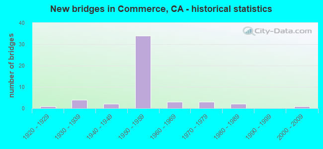
- New bridges - historical statistics
- 11920-1929
- 41930-1939
- 21940-1949
- 341950-1959
- 31960-1969
- 31970-1979
- 21980-1989
- 12000-2009

- Reconstructed bridges - Historical Statistics
- 61960-1969
- 21970-1979
- 11980-1989
- 11990-1999


- Bridge Condition - Deck
- 60.0%Good
- 33.3%Fair
- 6.7%Poor

- Bridge Condition - Superstructure
- 93.8%Good
- 6.3%Satisfactory

- Bridge Condition - Substructure
- 87.5%Good
- 6.3%Satisfactory
- 6.3%Poor

- Bridge Condition - Channel
- 83.3%Excellent
- 16.7%Good

- Bridge Condition - Culverts
- 40.0%Very good
- 60.0%Good
Find on map >> Show street view
Structure Number: 53 0025, Location: 07-LA-005-12.92-CMRC (Lat: 34.010206, Lng: -118.160164), Route carried "on" structure: City street , Year Built: 1950, Status: Open, Structure Length: 4.33m (14.21ft), Average Daily Traffic: 2,820 (year 2019), Truck Traffic: 3%, Average Future Daily Traffic: 4,446 (year 2038), Design Load: HS 20, Features Intersected: ROUTE 5, Facility Carried by Structure: TRIGGS AVENUE
Minimum Vertical Clearance: 30+ m (98+ ft), Kilometerpoint: 0.000, Lanes on structure: 2, Lanes under structure: 8, Owner: State Highway Agency, Approaching Roadway Width: 7.9m (25.9ft), Skew: 9 degrees, Material/Design: Concrete continuous, Design/Construction: Box Beam or Girders - Multiple, Number Of Spans In Main Unit: 2, Length of Maximum Span: 21.9m (71.9ft), Curb or Sidewalk Widths: Left: 0.6m (2.0ft), Right: 1.8m (5.9ft), Curb-To-Curb Width: 7.9m (25.9ft), Out-to-Out Width: 10.8m (35.4ft)
Condition: Deck: Good, Superstructure: Satisfactory, Substructure: Good, Operating Rating: 99.8 metric tons, Method Used To Determine Operating Rating: Load Factor (LF), Inventory Rating: 57.1 metric tons, Method Used To Determine Inventory Rating: Load Factor (LF), Structural Evaluation: Equal to present minimum criteria, Deck Geometry: High priority of corrective action, Underclear: High priority of corrective action, Approach Roadway Alignment: Equal to present desirable criteria, Designated Inspection Frequency: Every 48 months, Inspection Date: January 2021, Deck Structure Type: Concrete Cast-file-Place, Wearing Surface/Protective System: Wearing Surface: Monolithic Concrete
Find on map >> Show street view
Structure Number: 53 003, Location: 07-LA-001-50.36 (Lat: 34.033300, Lng: -118.742528), Route carried "on" structure: State highway 1, Year Built: 1947, Status: Open, Structure Length: 0.64m (2.10ft), Average Daily Traffic: 29,750 (year 2017), Truck Traffic: 3%, Average Future Daily Traffic: 45,544 (year 2040), Design Load: HS 20, Features Intersected: SOLSTICE CANYON CREEK
Minimum Vertical Clearance: 30+ m (98+ ft), Kilometerpoint: 50.360, Lanes on structure: 4, Base Highway Network: Yes (, Subroute: 1), Owner: State Highway Agency, Approaching Roadway Width: 22.6m (74.1ft), Skew: 4 degrees, Material/Design: Concrete, Design/Construction: Culvert, Number Of Spans In Main Unit: 1, Length of Maximum Span: 6.4m (21.0ft), Curb-To-Curb Width: 22.6m (74.1ft), Out-to-Out Width: 22.6m (74.1ft)
Condition: Channel: Good, Culverts: Very good, Operating Rating: 54.1 metric tons, Method Used To Determine Operating Rating: Field evaluation and documented engineering judgment, Inventory Rating: 32.4 metric tons, Method Used To Determine Inventory Rating: Field evaluation and documented engineering judgment, Structural Evaluation: Equal to present desirable criteria, Deck Geometry: Superior to present desirable criteria, Waterway Adequacy: Equal to present desirable criteria, Approach Roadway Alignment: Equal to present desirable criteria, Designated Inspection Frequency: Every 48 months, Inspection Date: December 2019
Find on map >> Show street view
Structure Number: 53 0607, Location: 07-LA-005-13.89-CMRC (Lat: 34.016606, Lng: -118.174747), Route carried "on" structure: City street L359, Year Built: 1951, Status: Open, Structure Length: 8.50m (27.89ft), Average Daily Traffic: 16,500 (year 2009), Truck Traffic: 2%, Average Future Daily Traffic: 24,054 (year 2036), Design Load: HS 20, Features Intersected: ROUTE 5 & CONN, Facility Carried by Structure: EASTERN AVE
Minimum Vertical Clearance: 30+ m (98+ ft), Kilometerpoint: 0.000, Lanes on structure: 2, Lanes under structure: 13, Owner: State Highway Agency, Approaching Roadway Width: 12.2m (40.0ft), Skew: 1 degrees, Material/Design: Concrete continuous, Design/Construction: Box Beam or Girders - Multiple, Number Of Spans In Main Unit: 3, Length of Maximum Span: 28.7m (94.2ft), Curb or Sidewalk Widths: Left: 1.2m (3.9ft), Right: 1.2m (3.9ft), Curb-To-Curb Width: 12.2m (40.0ft), Out-to-Out Width: 15.8m (51.8ft)
Condition: Deck: Good, Superstructure: Good, Substructure: Good, Operating Rating: 46.7 metric tons, Method Used To Determine Operating Rating: Load and Resistance Factor Rating (LRFR) rating reported by rating factor(RF) method using HL-93 loadings, Inventory Rating: 33.7 metric tons, Method Used To Determine Inventory Rating: Load and Resistance Factor Rating (LRFR) rating reported by rating factor(RF) method using HL-93 loadings, Structural Evaluation: Better than present minimum criteria, Deck Geometry: Somewhat better than minimum adequacy, Underclear: High priority of corrective action, Approach Roadway Alignment: Equal to present desirable criteria, Designated Inspection Frequency: Every 48 months, Inspection Date: January 2019, Deck Structure Type: Concrete Cast-file-Place, Wearing Surface/Protective System: Wearing Surface: Monolithic Concrete
Find on map >> Show street view
Structure Number: 53 0631R, Location: 07-LA-005-1.21-SFSP (Lat: 33.883564, Lng: -118.028772), Route carried "on" structure: City street L097, Year Built: 1976, Status: Open, Structure Length: 12.84m (42.13ft), Average Daily Traffic: 4,000 (year 2009), Truck Traffic: 2%, Average Future Daily Traffic: 6,005 (year 2042), Design Load: HS 20, Features Intersected: INTERSTATE 5, Facility Carried by Structure: VALLEY VIEW AVENUE
Minimum Vertical Clearance: 30+ m (98+ ft), Kilometerpoint: 0.000, Lanes on structure: 2, Lanes under structure: 11, Base Highway Network: Yes, Owner: State Highway Agency, Approaching Roadway Width: 11.6m (38.1ft), Skew: 3 degrees, Material/Design: Steel, Design/Construction: Stringer/Multi-beam, Number Of Spans In Main Unit: 4, Length of Maximum Span: 44.5m (146.0ft), Curb or Sidewalk Widths: Left: 0.0m, Right: 2.1m (6.9ft), Curb-To-Curb Width: 11.6m (38.1ft), Out-to-Out Width: 14.6m (47.9ft)
Condition: Deck: Fair, Superstructure: Good, Substructure: Good, Operating Rating: 54.1 metric tons, Method Used To Determine Operating Rating: Load and Resistance Factor Rating (LRFR) rating reported by rating factor(RF) method using HL-93 loadings, Inventory Rating: 41.8 metric tons, Method Used To Determine Inventory Rating: Load and Resistance Factor Rating (LRFR) rating reported by rating factor(RF) method using HL-93 loadings, Structural Evaluation: Better than present minimum criteria, Deck Geometry: Better than present minimum criteria, Underclear: High priority of corrective action, Approach Roadway Alignment: Superior to present desirable criteria, Designated Inspection Frequency: Every 24 months, Inspection Date: October 2020, Deck Structure Type: Concrete Cast-file-Place, Wearing Surface/Protective System: Wearing Surface: Monolithic Concrete
Find on map >> Show street view
Structure Number: 53 0635, Location: 07-LA-005-11.55-CMRC (Lat: 33.994972, Lng: -118.144403), Route carried "on" structure: Interstate 5, Year Built: 1953, Year Reconstructed: 1987, Status: Open, Structure Length: 6.32m (20.73ft), Average Daily Traffic: 218,000 (year 2011), Truck Traffic: 9%, Average Future Daily Traffic: 239,270 (year 2040), Design Load: HS 20, Features Intersected: WASHINGTON BLVD
Minimum Vertical Clearance: 30+ m (98+ ft), Kilometerpoint: 11.550, Lanes on structure: 8, Lanes under structure: 6, Base Highway Network: Yes (, Subroute: 1), Owner: State Highway Agency, Approaching Roadway Width: 38.1m (125.0ft), Skew: 36 degrees, Material/Design: Concrete continuous, Design/Construction: Box Beam or Girders - Multiple, Number Of Spans In Main Unit: 2, Length of Maximum Span: 30.8m (101.0ft), Curb-To-Curb Width: 38.2m (125.3ft), Out-to-Out Width: 39.9m (130.9ft)
Condition: Deck: Good, Superstructure: Good, Substructure: Good, Operating Rating: 99.8 metric tons, Method Used To Determine Operating Rating: Load Factor (LF), Inventory Rating: 66.2 metric tons, Method Used To Determine Inventory Rating: Load Factor (LF), Structural Evaluation: Better than present minimum criteria, Deck Geometry: Superior to present desirable criteria, Underclear: Meets minimum limits, Approach Roadway Alignment: Equal to present desirable criteria, Designated Inspection Frequency: Every 24 months, Inspection Date: November 2020, Deck Structure Type: Concrete Cast-file-Place
Find on map >> Show street view
Structure Number: 53 0637, Location: 07-LA-005-10.88-CMRC (Lat: 33.987564, Lng: -118.137219), Route carried "on" structure: Interstate 5, Year Built: 1952, Year Reconstructed: 1982, Status: Open, Structure Length: 4.59m (15.06ft), Average Daily Traffic: 218,000 (year 2011), Truck Traffic: 9%, Average Future Daily Traffic: 239,270 (year 2040), Design Load: HS 20, Features Intersected: GARFIELD AVE
Minimum Vertical Clearance: 30+ m (98+ ft), Kilometerpoint: 10.880, Lanes on structure: 8, Lanes under structure: 5, Base Highway Network: Yes (, Subroute: 1), Owner: State Highway Agency, Approaching Roadway Width: 37.2m (122.0ft), Skew: 21 degrees, Material/Design: Concrete continuous, Design/Construction: Slab, Number Of Spans In Main Unit: 4, Length of Maximum Span: 12.5m (41.0ft), Curb-To-Curb Width: 37.2m (122.0ft), Out-to-Out Width: 40.7m (133.5ft)
Condition: Deck: Good, Superstructure: Good, Substructure: Good, Operating Rating: 45.4 metric tons, Method Used To Determine Operating Rating: Load Factor (LF), Inventory Rating: 27.2 metric tons, Method Used To Determine Inventory Rating: Load Factor (LF), Structural Evaluation: Equal to present minimum criteria, Deck Geometry: Superior to present desirable criteria, Underclear: Meets minimum limits, Approach Roadway Alignment: Equal to present desirable criteria, Designated Inspection Frequency: Every 24 months, Inspection Date: November 2020, Deck Structure Type: Concrete Cast-file-Place, Wearing Surface/Protective System: Wearing Surface: Bituminous
Find on map >> Show street view
Structure Number: 53 0638, Location: 07-LA-005-9.70-CMRC (Lat: 33.974358, Lng: -118.124003), Route carried "on" structure: Interstate 5, Year Built: 1953, Year Reconstructed: 1982, Status: Open, Structure Length: 13.23m (43.41ft), Average Daily Traffic: 218,000 (year 2011), Average Future Daily Traffic: 248,102 (year 2040), Design Load: HS 20, Features Intersected: SLAUSON AVE & UP RR
Minimum Vertical Clearance: 30+ m (98+ ft), Kilometerpoint: 9.700, Lanes on structure: 8, Lanes under structure: 6, Base Highway Network: Yes (, Subroute: 1), Owner: State Highway Agency, Approaching Roadway Width: 37.8m (124.0ft), Skew: 24 degrees, Material/Design: Concrete continuous, Design/Construction: Box Beam or Girders - Multiple, Number Of Spans In Main Unit: 6, Length of Maximum Span: 33.8m (110.9ft), Curb or Sidewalk Widths: Left: 0.6m (2.0ft), Right: 0.6m (2.0ft), Curb-To-Curb Width: 37.9m (124.3ft), Out-to-Out Width: 41.5m (136.2ft)
Condition: Deck: Fair, Superstructure: Good, Substructure: Good, Operating Rating: 76.1 metric tons, Method Used To Determine Operating Rating: Load Factor (LF), Inventory Rating: 32.6 metric tons, Method Used To Determine Inventory Rating: Load Factor (LF), Structural Evaluation: Better than present minimum criteria, Deck Geometry: Superior to present desirable criteria, Underclear: Meets minimum limits, Approach Roadway Alignment: Equal to present desirable criteria, Designated Inspection Frequency: Every 24 months, Inspection Date: November 2020, Deck Structure Type: Concrete Cast-file-Place
Find on map >> Show street view
Structure Number: 53 078, Location: 07-LA-002-16.64-LA (Lat: 34.118131, Lng: -118.235233), Route carried "on" structure: City street Q400, Year Built: 1976, Status: Open, Structure Length: 6.34m (20.80ft), Average Daily Traffic: 6,300 (year 2019), Truck Traffic: 1%, Average Future Daily Traffic: 8,399 (year 2038), Design Load: HS 20, Features Intersected: ROUTE 2, Facility Carried by Structure: AVE 36 OC
Minimum Vertical Clearance: 30+ m (98+ ft), Kilometerpoint: 0.000, Lanes on structure: 4, Lanes under structure: 9, Owner: State Highway Agency, Approaching Roadway Width: 18.3m (60.0ft), Skew: 9 degrees, Material/Design: Prestressed concrete continuous, Design/Construction: Box Beam or Girders - Multiple, Number Of Spans In Main Unit: 2, Length of Maximum Span: 32.9m (107.9ft), Curb or Sidewalk Widths: Left: 3.0m (9.8ft), Right: 3.0m (9.8ft), Curb-To-Curb Width: 18.3m (60.0ft), Out-to-Out Width: 25.0m (82.0ft)
Condition: Deck: Poor, Superstructure: Good, Substructure: Good, Operating Rating: 51.5 metric tons, Method Used To Determine Operating Rating: Load and Resistance Factor Rating (LRFR) rating reported by rating factor(RF) method using HL-93 loadings, Inventory Rating: 36.6 metric tons, Method Used To Determine Inventory Rating: Load and Resistance Factor Rating (LRFR) rating reported by rating factor(RF) method using HL-93 loadings, Structural Evaluation: Better than present minimum criteria, Deck Geometry: Somewhat better than minimum adequacy, Underclear: High priority of corrective action, Approach Roadway Alignment: Equal to present desirable criteria, Designated Inspection Frequency: Every 24 months, Inspection Date: October 2021, Deck Structure Type: Concrete Cast-file-Place
Find on map >> Show street view
Structure Number: 53 0785R, Location: 07-LA-710-23.19-CMRC (Lat: 34.015417, Lng: -118.172197), Route carried "on" structure: Interstate 710, Year Built: 1954, Year Reconstructed: 1967, Status: Open, Structure Length: 21.46m (70.41ft), Average Daily Traffic: 216,000 (year 2017), Truck Traffic: 9%, Average Future Daily Traffic: 220,000 (year 2037), Design Load: HS 20, Features Intersected: ROUTE 5, CONN, TELEGRAPH
Minimum Vertical Clearance: 30+ m (98+ ft), Kilometerpoint: 23.190, Lanes on structure: 3, Lanes under structure: 12, Base Highway Network: Yes (Inventory Route: 7, Subroute: 1), Owner: State Highway Agency, Approaching Roadway Width: 13.4m (44.0ft), Skew: 9 degrees, Material/Design: Concrete continuous, Design/Construction: Box Beam or Girders - Multiple, Number Of Spans In Main Unit: 8, Length of Maximum Span: 39.6m (129.9ft), Curb-To-Curb Width: 13.4m (44.0ft), Out-to-Out Width: 14.5m (47.6ft)
Condition: Deck: Good, Superstructure: Good, Substructure: Good, Operating Rating: 86.1 metric tons, Method Used To Determine Operating Rating: Load Factor (LF), Inventory Rating: 32.4 metric tons, Method Used To Determine Inventory Rating: Load Factor (LF), Structural Evaluation: Better than present minimum criteria, Deck Geometry: Meets minimum limits, Underclear: High priority of corrective action, Approach Roadway Alignment: Somewhat better than minimum adequacy, Designated Inspection Frequency: Every 24 months, Inspection Date: August 2020, Deck Structure Type: Concrete Cast-file-Place
Find on map >> Show street view
Structure Number: 53 0788L, Location: 07-LA-710-23.21-CMRC (Lat: 34.015631, Lng: -118.172867), Route carried "on" structure: Interstate 710, Year Built: 1955, Year Reconstructed: 1967, Status: Open, Structure Length: 23.09m (75.75ft), Average Daily Traffic: 110,000 (year 2009), Truck Traffic: 9%, Average Future Daily Traffic: 102,917 (year 2037), Design Load: HS 20, Features Intersected: ROUTE 5, CONN, TELEGRAPH
Minimum Vertical Clearance: 30+ m (98+ ft), Kilometerpoint: 23.210, Lanes on structure: 3, Lanes under structure: 9, Base Highway Network: Yes (Inventory Route: 7, Subroute: 1), Owner: State Highway Agency, Approaching Roadway Width: 15.5m (50.9ft), Skew: 4 degrees, Material/Design: Concrete continuous, Design/Construction: Box Beam or Girders - Multiple, Number Of Spans In Main Unit: 7, Length of Maximum Span: 37.2m (122.0ft), Curb-To-Curb Width: 15.2m (49.9ft), Out-to-Out Width: 17.9m (58.7ft)
Condition: Deck: Fair, Superstructure: Good, Substructure: Good, Operating Rating: 75.5 metric tons, Method Used To Determine Operating Rating: Load Factor (LF), Inventory Rating: 45.4 metric tons, Method Used To Determine Inventory Rating: Load Factor (LF), Structural Evaluation: Better than present minimum criteria, Deck Geometry: Meets minimum limits, Underclear: High priority of corrective action, Approach Roadway Alignment: Somewhat better than minimum adequacy, Designated Inspection Frequency: Every 24 months, Inspection Date: August 2020, Deck Structure Type: Concrete Cast-file-Place
Find on map >> Show street view
Structure Number: 53 0789E, Location: 07-LA-710-23.26-CMRC (Lat: 34.016242, Lng: -118.172686), Route carried "on" structure: Ramp Interstate 710, Year Built: 1956, Status: Open, Structure Length: 14.08m (46.19ft), Average Daily Traffic: 45,900 (year 2010), Truck Traffic: 2%, Average Future Daily Traffic: 65,500 (year 2037), Design Load: HS 20, Features Intersected: I 5 NB & TELEGRAPH
Minimum Vertical Clearance: 30+ m (98+ ft), Kilometerpoint: 23.260, Lanes on structure: 2, Lanes under structure: 11, Base Highway Network: Yes, Owner: State Highway Agency, Approaching Roadway Width: 16.2m (53.1ft), Skew: 25 degrees, Material/Design: Concrete continuous, Design/Construction: Box Beam or Girders - Multiple, Number Of Spans In Main Unit: 6, Length of Maximum Span: 38.1m (125.0ft), Curb-To-Curb Width: 13.4m (44.0ft), Out-to-Out Width: 17.6m (57.7ft)
Condition: Deck: Fair, Superstructure: Good, Substructure: Good, Operating Rating: 99.8 metric tons, Method Used To Determine Operating Rating: Load Factor (LF), Inventory Rating: 55.3 metric tons, Method Used To Determine Inventory Rating: Load Factor (LF), Structural Evaluation: Better than present minimum criteria, Deck Geometry: Superior to present desirable criteria, Underclear: High priority of corrective action, Approach Roadway Alignment: Meets minimum limits, Designated Inspection Frequency: Every 24 months, Inspection Date: August 2020, Deck Structure Type: Concrete Cast-file-Place
Find on map >> Show street view
Structure Number: 53 0841, Location: 07-LA-710-22.45-CMRC (Lat: 34.004547, Lng: -118.172789), Route carried "on" structure: Interstate 710, Year Built: 1955, Year Reconstructed: 1967, Status: Open, Structure Length: 3.20m (10.50ft), Average Daily Traffic: 217,000 (year 2017), Truck Traffic: 9%, Average Future Daily Traffic: 225,835 (year 2037), Design Load: HS 20, Features Intersected: WASHINGTON BLVD
Minimum Vertical Clearance: 30+ m (98+ ft), Kilometerpoint: 22.450, Lanes on structure: 10, Lanes under structure: 4, Base Highway Network: Yes (Inventory Route: 7, Subroute: 1), Owner: State Highway Agency, Approaching Roadway Width: 46.0m (150.9ft), Skew: 30 degrees, Material/Design: Concrete, Design/Construction: Tee Beam, Number Of Spans In Main Unit: 1, Length of Maximum Span: 31.7m (104.0ft), Curb-To-Curb Width: 41.9m (137.5ft), Out-to-Out Width: 44.7m (146.7ft)
Condition: Deck: Good, Superstructure: Good, Substructure: Good, Operating Rating: 41.8 metric tons, Method Used To Determine Operating Rating: Load and Resistance Factor Rating (LRFR) rating reported by rating factor(RF) method using HL-93 loadings, Inventory Rating: 32.4 metric tons, Method Used To Determine Inventory Rating: Load and Resistance Factor Rating (LRFR) rating reported by rating factor(RF) method using HL-93 loadings, Structural Evaluation: Better than present minimum criteria, Deck Geometry: Equal to present minimum criteria, Underclear: Equal to present minimum criteria, Approach Roadway Alignment: Equal to present desirable criteria, Designated Inspection Frequency: Every 24 months, Inspection Date: July 2020, Deck Structure Type: Concrete Cast-file-Place
Find on map >> Show street view
Structure Number: 53 0842, Location: 07-LA-710-22.66-CMRC (Lat: 34.007544, Lng: -118.172225), Route carried "on" structure: Interstate 710, Year Built: 1954, Year Reconstructed: 1967, Status: Open, Structure Length: 42.54m (139.57ft), Average Daily Traffic: 216,000 (year 2017), Truck Traffic: 9%, Average Future Daily Traffic: 225,835 (year 2037), Design Load: HS 20, Features Intersected: UP RR & NOAKES STREET
Minimum Vertical Clearance: 30+ m (98+ ft), Kilometerpoint: 22.660, Lanes on structure: 10, Lanes under structure: 2, Base Highway Network: Yes (Inventory Route: 7, Subroute: 1), Owner: State Highway Agency, Approaching Roadway Width: 38.1m (125.0ft), Skew: 39 degrees, Material/Design: Steel, Design/Construction: Stringer/Multi-beam, Number Of Spans In Main Unit: 14, Length of Maximum Span: 35.7m (117.1ft), Curb-To-Curb Width: 36.0m (118.1ft), Out-to-Out Width: 36.7m (120.4ft)
Condition: Deck: Fair, Superstructure: Good, Substructure: Good, Operating Rating: 57.0 metric tons, Method Used To Determine Operating Rating: Load Factor (LF), Inventory Rating: 34.3 metric tons, Method Used To Determine Inventory Rating: Load Factor (LF), Structural Evaluation: Better than present minimum criteria, Deck Geometry: High priority of corrective action, Underclear: Meets minimum limits, Approach Roadway Alignment: Equal to present desirable criteria, Designated Inspection Frequency: Every 24 months, Other Special Inspection Frequency: Every 48 months, Inspection Date: July 2020, Other Special Inspection Date: April 2018, Deck Structure Type: Concrete Cast-file-Place, Wearing Surface/Protective System: Wearing Surface: Integral Concrete
Find on map >> Show street view
Structure Number: 53 086, Location: 07-LA-010-47.74-CLA (Lat: 34.081536, Lng: -117.719431), Route carried "on" structure: Interstate 10, Year Built: 1954, Year Reconstructed: 2003, Status: Open, Structure Length: 2.55m (8.37ft), Average Daily Traffic: 247,000 (year 2012), Truck Traffic: 7%, Average Future Daily Traffic: 275,377 (year 2038), Design Load: HS 20, Features Intersected: INDIAN HILL BLVD
Minimum Vertical Clearance: 30+ m (98+ ft), Kilometerpoint: 47.740, Lanes on structure: 10, Lanes under structure: 5, Base Highway Network: Yes (, Subroute: 1), Owner: State Highway Agency, Approaching Roadway Width: 48.8m (160.1ft), Skew: 30 degrees, Material/Design: Prestressed concrete, Design/Construction: Box Beam or Girders - Multiple, Number Of Spans In Main Unit: 1, Length of Maximum Span: 24.8m (81.4ft), Curb-To-Curb Width: 48.8m (160.1ft), Out-to-Out Width: 50.3m (165.0ft)
Condition: Deck: Good, Superstructure: Good, Substructure: Good, Operating Rating: 83.6 metric tons, Method Used To Determine Operating Rating: Load Factor (LF), Inventory Rating: 50.2 metric tons, Method Used To Determine Inventory Rating: Load Factor (LF), Structural Evaluation: Better than present minimum criteria, Deck Geometry: Superior to present desirable criteria, Underclear: Meets minimum limits, Approach Roadway Alignment: Equal to present desirable criteria, Designated Inspection Frequency: Every 24 months, Inspection Date: September 2021, Deck Structure Type: Concrete Cast-file-Place, Wearing Surface/Protective System: Wearing Surface: Integral Concrete
Find on map >> Show street view
Structure Number: 53 0869, Location: 07-LA-710-23.14-CMRC (Lat: 34.014542, Lng: -118.172100), Route carried "on" structure: Interstate 710, Year Built: 1955, Year Reconstructed: 1967, Status: Open, Structure Length: 1.83m (6.00ft), Average Daily Traffic: 216,000 (year 2017), Truck Traffic: 9%, Average Future Daily Traffic: 225,835 (year 2037), Design Load: HS 20, Features Intersected: TRIGGS STREET
Minimum Vertical Clearance: 30+ m (98+ ft), Kilometerpoint: 23.140, Lanes on structure: 11, Lanes under structure: 2, Base Highway Network: Yes (Inventory Route: 7, Subroute: 1), Owner: State Highway Agency, Approaching Roadway Width: 56.1m (184.1ft), Skew: 30 degrees, Material/Design: Concrete, Design/Construction: Slab, Number Of Spans In Main Unit: 1, Length of Maximum Span: 17.1m (56.1ft), Curb or Sidewalk Widths: Left: 0.3m (1.0ft), Right: 0.0m, Curb-To-Curb Width: 57.3m (188.0ft), Out-to-Out Width: 58.5m (191.9ft)
Condition: Deck: Good, Superstructure: Good, Substructure: Good, Operating Rating: 57.3 metric tons, Method Used To Determine Operating Rating: Load Factor (LF), Inventory Rating: 32.4 metric tons, Method Used To Determine Inventory Rating: Load Factor (LF), Structural Evaluation: Better than present minimum criteria, Deck Geometry: Superior to present desirable criteria, Underclear: Equal to present minimum criteria, Approach Roadway Alignment: Somewhat better than minimum adequacy, Designated Inspection Frequency: Every 24 months, Inspection Date: July 2020
Find on map >> Show street view
Structure Number: 53C0151, Location: 0.4 MI SW/O US 101 (Lat: 34.057772, Lng: -118.252264), Route carried "on" structure: City street , Year Built: 1940, Year Reconstructed: 1971, Status: Open, Structure Length: 4.45m (14.60ft), Average Daily Traffic: 17,257 (year 2018), Truck Traffic: 3%, Average Future Daily Traffic: 32,313 (year 2040), Design Load: HS 20, Features Intersected: FIGUEROA STREET, Facility Carried by Structure: FIRST STREET
Minimum Vertical Clearance: 30+ m (98+ ft), Kilometerpoint: 0.000, Lanes on structure: 5, Lanes under structure: 4, Base Highway Network: Yes, Owner: City or Municipal Highway Agency, Approaching Roadway Width: 24.4m (80.1ft), Material/Design: Steel continuous, Design/Construction: Stringer/Multi-beam, Number Of Spans In Main Unit: 3, Length of Maximum Span: 28.5m (93.5ft), Curb or Sidewalk Widths: Left: 2.7m (8.9ft), Right: 2.7m (8.9ft), Curb-To-Curb Width: 24.4m (80.1ft), Out-to-Out Width: 31.0m (101.7ft)
Condition: Deck: Good, Superstructure: Good, Substructure: Poor, Operating Rating: 54.1 metric tons, Method Used To Determine Operating Rating: Load Factor (LF), Inventory Rating: 32.4 metric tons, Method Used To Determine Inventory Rating: Load Factor (LF), Structural Evaluation: Meets minimum limits, Deck Geometry: Superior to present desirable criteria, Underclear: Equal to present minimum criteria, Approach Roadway Alignment: Better than present minimum criteria, Designated Inspection Frequency: Every 24 months, Inspection Date: August 2020, Deck Structure Type: Concrete Cast-file-Place, Wearing Surface/Protective System: Wearing Surface: Bituminous
Find on map >> Show street view
Structure Number: 53C0252, Location: 0.6MI N/O SLAUSON AVE (Lat: 33.994172, Lng: -118.182397), Route carried "on" structure: City street L062, Year Built: 1931, Status: Open, Structure Length: 14.14m (46.39ft), Average Daily Traffic: 58,397 (year 2012), Truck Traffic: 19%, Average Future Daily Traffic: 70,076 (year 2040), Features Intersected: LOS ANGELES RIV, Facility Carried by Structure: ATLANTIC BLVD
Minimum Vertical Clearance: 30.47m (99.97ft), Kilometerpoint: 0.000, Lanes on structure: 6, Owner: City or Municipal Highway Agency, Approaching Roadway Width: 19.5m (64.0ft), Material/Design: Concrete continuous, Design/Construction: Arch - Deck, Number Of Spans In Main Unit: 7, Length of Maximum Span: 18.3m (60.0ft), Curb or Sidewalk Widths: Left: 1.2m (3.9ft), Right: 1.2m (3.9ft), Curb-To-Curb Width: 18.3m (60.0ft), Out-to-Out Width: 21.8m (71.5ft)
Condition: Superstructure: Good, Substructure: Satisfactory, Channel: Excellent, Operating Rating: 99.8 metric tons, Method Used To Determine Operating Rating: Load Factor (LF), Inventory Rating: 64.8 metric tons, Method Used To Determine Inventory Rating: Load Factor (LF), Structural Evaluation: Equal to present minimum criteria, Deck Geometry: High priority of replacement, Waterway Adequacy: Superior to present desirable criteria, Approach Roadway Alignment: Better than present minimum criteria, Designated Inspection Frequency: Every 24 months, Inspection Date: September 2020
Find on map >> Show street view
Structure Number: 53C077, Location: 0.3MI S/O FOOTHILL BLVD (Lat: 34.213775, Lng: -118.227736), Route carried "on" structure: County highway Q259, Year Built: 1936, Status: Open, Structure Length: 1.22m (4.00ft), Average Daily Traffic: 16,230 (year 2012), Truck Traffic: 2%, Average Future Daily Traffic: 19,476 (year 2040), Features Intersected: HALLS CYN CHAN, Facility Carried by Structure: OCEAN VIEW BLVD
Minimum Vertical Clearance: 30.47m (99.97ft), Kilometerpoint: 0.000, Lanes on structure: 4, Owner: County Highway Agency, Approaching Roadway Width: 19.5m (64.0ft), Skew: 5 degrees, Material/Design: Concrete, Design/Construction: Culvert, Number Of Spans In Main Unit: 1, Length of Maximum Span: 7.0m (23.0ft), Curb or Sidewalk Widths: Left: 2.3m (7.5ft), Right: 1.7m (5.6ft), Curb-To-Curb Width: 19.4m (63.6ft), Out-to-Out Width: 25.0m (82.0ft)
Condition: Channel: Excellent, Culverts: Good, Operating Rating: 72.3 metric tons, Method Used To Determine Operating Rating: Load Factor (LF), Inventory Rating: 43.4 metric tons, Method Used To Determine Inventory Rating: Load Factor (LF), Structural Evaluation: Better than present minimum criteria, Deck Geometry: Better than present minimum criteria, Waterway Adequacy: Superior to present desirable criteria, Approach Roadway Alignment: Equal to present desirable criteria, Designated Inspection Frequency: Every 48 months, Inspection Date: Febuary 2020, Deck Structure Type: Concrete Cast-file-Place, Wearing Surface/Protective System: Wearing Surface: Bituminous
Find on map >> Show street view
Structure Number: 53C0791, Location: 0.4MI W/O GAREY AVE (Lat: 34.088489, Lng: -117.756017), Route carried "on" structure: City street Q937, Year Built: 1965, Status: Open, Structure Length: 0.85m (2.79ft), Average Daily Traffic: 7,800 (year 2013), Truck Traffic: 1%, Average Future Daily Traffic: 10,674 (year 2041), Design Load: HS 20, Features Intersected: THOMPSON CRK, Facility Carried by Structure: LA VERNE AVE
Minimum Vertical Clearance: 6.10m (20.01ft), Kilometerpoint: 0.000, Lanes on structure: 2, Owner: City or Municipal Highway Agency, Approaching Roadway Width: 17.1m (56.1ft), Skew: 3 degrees, Material/Design: Concrete, Design/Construction: Culvert, Number Of Spans In Main Unit: 1, Length of Maximum Span: 7.6m (24.9ft), Curb or Sidewalk Widths: Left: 1.5m (4.9ft), Right: 2.0m (6.6ft), Curb-To-Curb Width: 17.1m (56.1ft), Out-to-Out Width: 30.6m (100.4ft)
Condition: Channel: Excellent, Culverts: Good, Operating Rating: 54.5 metric tons, Method Used To Determine Operating Rating: Load Factor (LF), Inventory Rating: 32.7 metric tons, Method Used To Determine Inventory Rating: Load Factor (LF), Structural Evaluation: Better than present minimum criteria, Deck Geometry: Superior to present desirable criteria, Waterway Adequacy: Superior to present desirable criteria, Approach Roadway Alignment: Equal to present desirable criteria, Designated Inspection Frequency: Every 48 months, Inspection Date: November 2021, Deck Structure Type: Concrete Cast-file-Place, Wearing Surface/Protective System: Wearing Surface: Bituminous
Find on map >> Show street view
Structure Number: 53C1052, Location: 0.5MI S/O FOOTHILL BLVD (Lat: 34.198339, Lng: -118.201028), Route carried "on" structure: City street L482, Year Built: 1937, Status: Open, Structure Length: 1.07m (3.51ft), Average Daily Traffic: 4,080 (year 2012), Truck Traffic: 2%, Average Future Daily Traffic: 4,488 (year 2040), Features Intersected: HAY CYN CHAN, Facility Carried by Structure: CHEVY CHASE
Minimum Vertical Clearance: 30.47m (99.97ft), Kilometerpoint: 0.000, Lanes on structure: 2, Owner: City or Municipal Highway Agency, Approaching Roadway Width: 12.2m (40.0ft), Skew: 4 degrees, Material/Design: Concrete, Design/Construction: Culvert, Number Of Spans In Main Unit: 2, Length of Maximum Span: 3.7m (12.1ft), Curb or Sidewalk Widths: Left: 0.2m (0.7ft), Right: 0.2m (0.7ft), Curb-To-Curb Width: 12.0m (39.4ft), Out-to-Out Width: 12.0m (39.4ft)
Condition: Channel: Excellent, Culverts: Very good, Operating Rating: 77.8 metric tons, Method Used To Determine Operating Rating: Load Factor (LF), Inventory Rating: 46.7 metric tons, Method Used To Determine Inventory Rating: Load Factor (LF), Structural Evaluation: Equal to present desirable criteria, Deck Geometry: Somewhat better than minimum adequacy, Waterway Adequacy: Superior to present desirable criteria, Approach Roadway Alignment: Equal to present minimum criteria, Designated Inspection Frequency: Every 48 months, Inspection Date: September 2020
Find on map >> Show street view
Structure Number: 53C1871, Location: 0.1MI S/O ALLEN AVE (Lat: 34.113744, Lng: -117.790928), Route carried "on" structure: City street L529, Year Built: 1985, Status: Open, Structure Length: 4.50m (14.76ft), Average Daily Traffic: 3,174 (year 2012), Truck Traffic: 2%, Average Future Daily Traffic: 3,491 (year 2041), Features Intersected: PUDDINGSTONE CHAN, Facility Carried by Structure: GLADSTONE ST
Minimum Vertical Clearance: 30+ m (98+ ft), Kilometerpoint: 0.000, Lanes on structure: 2, Owner: County Highway Agency, Approaching Roadway Width: 12.1m (39.7ft), Skew: 4 degrees, Material/Design: Concrete, Design/Construction: Culvert, Number Of Spans In Main Unit: 1, Length of Maximum Span: 7.6m (24.9ft), Curb or Sidewalk Widths: Left: 0.2m (0.7ft), Right: 0.2m (0.7ft), Curb-To-Curb Width: 10.4m (34.1ft), Out-to-Out Width: 11.0m (36.1ft)
Condition: Channel: Excellent, Culverts: Good, Operating Rating: 54.5 metric tons, Method Used To Determine Operating Rating: Field evaluation and documented engineering judgment, Inventory Rating: 32.7 metric tons, Method Used To Determine Inventory Rating: Field evaluation and documented engineering judgment, Structural Evaluation: Better than present minimum criteria, Deck Geometry: Somewhat better than minimum adequacy, Waterway Adequacy: Superior to present desirable criteria, Approach Roadway Alignment: Equal to present desirable criteria, Designated Inspection Frequency: Every 48 months, Inspection Date: October 2021
Find on map >> Show street view
Structure Number: 53 0025, Location: 07-LA-005-12.92-CMRC (Lat: 34.010206, Lng: -118.160164), Route carried "under" structure: Interstate 5, Year Built: 1950, Structure Length: 0. m, Average Daily Traffic: 227,000 (year 2019), Truck Traffic: 9%, Features Intersected: ROUTE 5, Facility Carried by Structure: TRIGGS AVENUE
Minimum Vertical Clearance: 4.72m (15.49ft), Kilometerpoint: 12.920, Lanes on structure: 2, Lanes under structure: 8, Material/Design: Concrete continuous, Design/Construction: Box Beam or Girders - Multiple, Length of Maximum Span: 21.9m (71.9ft)
Find on map >> Show street view
Structure Number: 53 0037, Location: 07-LA-005-12.90-CMRC (Lat: 34.009947, Lng: -118.159986), Route carried "under" structure: Interstate 5, Year Built: 1950, Structure Length: 0. m, Average Daily Traffic: 227,000 (year 2009), Truck Traffic: 9%, Features Intersected: UP RR & METROLINK
Minimum Vertical Clearance: 4.62m (15.16ft), Kilometerpoint: 12.900, Lanes under structure: 8, Material/Design: Steel, Design/Construction: Stringer/Multi-beam, Length of Maximum Span: 21.6m (70.9ft)
Find on map >> Show street view
Structure Number: 53 0041, Location: 07-LA-005-12.80-CMRC (Lat: 34.008542, Lng: -118.158667), Route carried "under" structure: Interstate 5, Year Built: 1950, Structure Length: 0. m, Average Daily Traffic: 227,000 (year 2011), Truck Traffic: 9%, Features Intersected: ROUTE 5, Facility Carried by Structure: ATLANTIC BLVD
Minimum Vertical Clearance: 4.52m (14.83ft), Kilometerpoint: 12.800, Lanes on structure: 6, Lanes under structure: 8, Material/Design: Concrete continuous, Design/Construction: Box Beam or Girders - Multiple, Length of Maximum Span: 20.1m (65.9ft)
Find on map >> Show street view
Structure Number: 53 0607, Location: 07-LA-005-13.89-CMRC (Lat: 34.016606, Lng: -118.174747), Route carried "under" structure: Ramp Interstate 5, Year Built: 1951, Structure Length: 0. m, Average Daily Traffic: 39,000 (year 2009), Truck Traffic: 8%, Features Intersected: ROUTE 5 & CONN, Facility Carried by Structure: EASTERN AVE
Minimum Vertical Clearance: 4.82m (15.81ft), Kilometerpoint: 13.890, Lanes on structure: 2, Lanes under structure: 3, Material/Design: Concrete continuous, Design/Construction: Box Beam or Girders - Multiple, Length of Maximum Span: 28.7m (94.2ft)
Find on map >> Show street view
Structure Number: 53 0607, Location: 07-LA-005-13.89-CMRC (Lat: 34.016606, Lng: -118.174747), Route carried "under" structure: Interstate 5, Year Built: 1951, Structure Length: 0. m, Average Daily Traffic: 251,000 (year 2009), Truck Traffic: 7%, Features Intersected: ROUTE 5 & CONN, Facility Carried by Structure: EASTERN AVE
Minimum Vertical Clearance: 4.52m (14.83ft), Kilometerpoint: 13.890, Lanes on structure: 2, Lanes under structure: 10, Material/Design: Concrete continuous, Design/Construction: Box Beam or Girders - Multiple, Length of Maximum Span: 28.7m (94.2ft)
Find on map >> Show street view
Structure Number: 53 0635, Location: 07-LA-005-11.55-CMRC (Lat: 33.994972, Lng: -118.144403), Route carried "under" structure: City street L106, Year Built: 1953, Structure Length: 0. m, Average Daily Traffic: 20,500 (year 2011), Truck Traffic: 3%, Features Intersected: WASHINGTON BLVD, Facility Carried by Structure: I 5
Minimum Vertical Clearance: 4.60m (15.09ft), Kilometerpoint: 0.000, Lanes on structure: 8, Lanes under structure: 6, Material/Design: Concrete continuous, Design/Construction: Box Beam or Girders - Multiple, Length of Maximum Span: 30.8m (101.0ft)
Find on map >> Show street view
Structure Number: 53 0636, Location: 07-LA-005-11.04-CMRC (Lat: 33.989344, Lng: -118.139614), Route carried "under" structure: Interstate 5, Year Built: 1952, Structure Length: 0. m, Average Daily Traffic: 218,000 (year 2009), Truck Traffic: 9%, Features Intersected: INTERSTATE 5, Facility Carried by Structure: BNSF,AMTRAK,METRO
Minimum Vertical Clearance: 4.62m (15.16ft), Kilometerpoint: 11.040, Lanes under structure: 8, Material/Design: Steel, Design/Construction: Girder and Floorbeam System, Length of Maximum Span: 31.7m (104.0ft)
Find on map >> Show street view
Structure Number: 53 0637, Location: 07-LA-005-10.88-CMRC (Lat: 33.987564, Lng: -118.137219), Route carried "under" structure: City street L064, Year Built: 1952, Structure Length: 0. m, Average Daily Traffic: 25,800 (year 2011), Truck Traffic: 2%, Features Intersected: GARFIELD AVE, Facility Carried by Structure: INTERSTATE 5
Minimum Vertical Clearance: 4.55m (14.93ft), Kilometerpoint: 0.000, Lanes on structure: 8, Lanes under structure: 5, Material/Design: Concrete continuous, Design/Construction: Slab, Length of Maximum Span: 12.5m (41.0ft)
Find on map >> Show street view
Structure Number: 53 0638, Location: 07-LA-005-9.70-CMRC (Lat: 33.974358, Lng: -118.124003), Route carried "under" structure: City street , Year Built: 1953, Structure Length: 0. m, Average Daily Traffic: 18,500 (year 2011), Truck Traffic: 4%, Features Intersected: SLAUSON AVE & UP RR, Facility Carried by Structure: INTERSTATE 5
Minimum Vertical Clearance: 5.53m (18.14ft), Kilometerpoint: 0.000, Lanes on structure: 8, Lanes under structure: 6, Material/Design: Concrete continuous, Design/Construction: Box Beam or Girders - Multiple, Length of Maximum Span: 33.8m (110.9ft)
Find on map >> Show street view
Structure Number: 53 0785R, Location: 07-LA-710-23.19-CMRC (Lat: 34.015417, Lng: -118.172197), Route carried "under" structure: Interstate 5, Year Built: 1954, Structure Length: 0. m, Average Daily Traffic: 228,000 (year 2015), Truck Traffic: 9%, Features Intersected: ROUTE 5, CONN, TELEGRAPH, Facility Carried by Structure: ROUTE 710 NB
Minimum Vertical Clearance: 8.76m (28.74ft), Kilometerpoint: 13.730, Lanes on structure: 3, Lanes under structure: 6, Material/Design: Concrete continuous, Design/Construction: Box Beam or Girders - Multiple, Length of Maximum Span: 39.6m (129.9ft)
Find on map >> Show street view
Structure Number: 53 0785R, Location: 07-LA-710-23.19-CMRC (Lat: 34.015417, Lng: -118.172197), Route carried "under" structure: Ramp Interstate 710, Year Built: 1954, Structure Length: 0. m, Average Daily Traffic: 30,000 (year 2010), Truck Traffic: 13%, Features Intersected: ROUTE 5, CONN, TELEGRAPH
Minimum Vertical Clearance: 4.62m (15.16ft), Kilometerpoint: 23.190, Lanes on structure: 3, Lanes under structure: 2, Material/Design: Concrete continuous, Design/Construction: Box Beam or Girders - Multiple, Length of Maximum Span: 39.6m (129.9ft)
Find on map >> Show street view
Structure Number: 53 0785R, Location: 07-LA-710-23.19-CMRC (Lat: 34.015417, Lng: -118.172197), Route carried "under" structure: City street L165, Year Built: 1954, Structure Length: 0. m, Average Daily Traffic: 5,000 (year 2010), Truck Traffic: 1%, Features Intersected: ROUTE 5, CONN, TELEGRAPH, Facility Carried by Structure: ROUTE 710 NB
Minimum Vertical Clearance: 5.69m (18.67ft), Kilometerpoint: 0.000, Lanes on structure: 3, Lanes under structure: 4, Material/Design: Concrete continuous, Design/Construction: Box Beam or Girders - Multiple, Length of Maximum Span: 39.6m (129.9ft)
Find on map >> Show street view
Structure Number: 53 0788L, Location: 07-LA-710-23.21-CMRC (Lat: 34.015631, Lng: -118.172867), Route carried "under" structure: Interstate 5, Year Built: 1955, Structure Length: 0. m, Average Daily Traffic: 228,000 (year 2017), Truck Traffic: 9%, Features Intersected: ROUTE 5, CONN, TELEGRAPH, Facility Carried by Structure: ROUTE 710 SB
Minimum Vertical Clearance: 9.88m (32.41ft), Kilometerpoint: 13.780, Lanes on structure: 3, Lanes under structure: 6, Material/Design: Concrete continuous, Design/Construction: Box Beam or Girders - Multiple, Length of Maximum Span: 37.2m (122.0ft)
Find on map >> Show street view
Structure Number: 53 0788L, Location: 07-LA-710-23.21-CMRC (Lat: 34.015631, Lng: -118.172867), Route carried "under" structure: Ramp Interstate 710, Year Built: 1955, Structure Length: 0. m, Average Daily Traffic: 30,000 (year 2010), Truck Traffic: 13%, Features Intersected: ROUTE 5, CONN, TELEGRAPH
Minimum Vertical Clearance: 6.83m (22.41ft), Kilometerpoint: 23.210, Lanes on structure: 3, Lanes under structure: 1, Material/Design: Concrete continuous, Design/Construction: Box Beam or Girders - Multiple, Length of Maximum Span: 37.2m (122.0ft)
Find on map >> Show street view
Structure Number: 53 0788L, Location: 07-LA-710-23.21-CMRC (Lat: 34.015631, Lng: -118.172867), Route carried "under" structure: City street L165, Year Built: 1955, Structure Length: 0. m, Average Daily Traffic: 5,000 (year 2010), Truck Traffic: 1%, Features Intersected: ROUTE 5, CONN, TELEGRAPH, Facility Carried by Structure: ROUTE 710 SB
Minimum Vertical Clearance: 4.97m (16.31ft), Kilometerpoint: 0.000, Lanes on structure: 3, Lanes under structure: 2, Material/Design: Concrete continuous, Design/Construction: Box Beam or Girders - Multiple, Length of Maximum Span: 37.2m (122.0ft)
Find on map >> Show street view
Structure Number: 53 0789E, Location: 07-LA-710-23.26-CMRC (Lat: 34.016242, Lng: -118.172686), Route carried "under" structure: County highway L165, Year Built: 1956, Structure Length: 0. m, Average Daily Traffic: 2,500 (year 2010), Truck Traffic: 1%, Features Intersected: I 5 NB & TELEGRAPH, Facility Carried by Structure: S710-S5 & N5-N710
Minimum Vertical Clearance: 4.64m (15.22ft), Kilometerpoint: 0.000, Lanes on structure: 2, Lanes under structure: 7, Material/Design: Concrete continuous, Design/Construction: Box Beam or Girders - Multiple, Length of Maximum Span: 38.1m (125.0ft)
Find on map >> Show street view
Structure Number: 53 0789E, Location: 07-LA-710-23.26-CMRC (Lat: 34.016242, Lng: -118.172686), Route carried "under" structure: Interstate 5, Year Built: 1956, Structure Length: 0. m, Average Daily Traffic: 228,000 (year 2017), Truck Traffic: 9%, Features Intersected: I 5 NB & TELEGRAPH
Minimum Vertical Clearance: 5.10m (16.73ft), Kilometerpoint: 13.780, Lanes on structure: 2, Lanes under structure: 4, Material/Design: Concrete continuous, Design/Construction: Box Beam or Girders - Multiple, Length of Maximum Span: 38.1m (125.0ft)
Find on map >> Show street view
Structure Number: 53 0790G, Location: 07-LA-710-23.20-CMRC (Lat: 34.015478, Lng: -118.172486), Route carried "under" structure: Interstate 5, Year Built: 1955, Structure Length: 0. m, Average Daily Traffic: 232,000 (year 2017), Truck Traffic: 9%, Features Intersected: ROUTE 5 SB
Minimum Vertical Clearance: 4.72m (15.49ft), Kilometerpoint: 13.780, Lanes on structure: 2, Lanes under structure: 3, Material/Design: Concrete continuous, Design/Construction: Box Beam or Girders - Multiple, Length of Maximum Span: 32.3m (106.0ft)
Find on map >> Show street view
Structure Number: 53 0803, Location: 07-LA-005-10.06-CMRC (Lat: 33.978806, Lng: -118.128122), Route carried "under" structure: Interstate 5, Year Built: 1978, Structure Length: 0. m, Average Daily Traffic: 218,000 (year 2009), Features Intersected: INTERSTATE 5, Facility Carried by Structure: PEDESTRIAN WALKWAY
Minimum Vertical Clearance: 5.54m (18.18ft), Kilometerpoint: 10.060, Lanes under structure: 8, Material/Design: Prestressed concrete, Design/Construction: Box Beam or Girders - Multiple, Length of Maximum Span: 39.6m (129.9ft)
Find on map >> Show street view
Structure Number: 53 0841, Location: 07-LA-710-22.45-CMRC (Lat: 34.004547, Lng: -118.172789), Route carried "under" structure: City street L106, Year Built: 1955, Structure Length: 0. m, Average Daily Traffic: 32,000 (year 2012), Truck Traffic: 2%, Features Intersected: WASHINGTON BLVD, Facility Carried by Structure: I 710
Minimum Vertical Clearance: 4.67m (15.32ft), Kilometerpoint: 0.000, Lanes on structure: 10, Lanes under structure: 4, Material/Design: Concrete, Design/Construction: Tee Beam, Length of Maximum Span: 31.7m (104.0ft)
Find on map >> Show street view
Structure Number: 53 0869, Location: 07-LA-710-23.14-CMRC (Lat: 34.014542, Lng: -118.172100), Route carried "under" structure: City street Q623, Year Built: 1955, Structure Length: 0. m, Average Daily Traffic: 1,000 (year 2009), Truck Traffic: 1%, Features Intersected: TRIGGS STREET, Facility Carried by Structure: ROUTE 710
Minimum Vertical Clearance: 4.57m (14.99ft), Kilometerpoint: 0.000, Lanes on structure: 11, Lanes under structure: 2, Material/Design: Concrete, Design/Construction: Slab, Length of Maximum Span: 17.1m (56.1ft)
Find on map >> Show street view
Structure Number: 53 1542, Location: 07-LA-005-13.57-CMRC (Lat: 34.014736, Lng: -118.169683), Route carried "under" structure: Interstate 5, Year Built: 1961, Structure Length: 0. m, Average Daily Traffic: 227,000 (year 2009), Truck Traffic: 9%, Features Intersected: INTERSTATE 5, Facility Carried by Structure: PEDESTRIAN WALKWAY
Minimum Vertical Clearance: 4.57m (14.99ft), Kilometerpoint: 13.570, Lanes under structure: 10, Material/Design: Prestressed concrete, Design/Construction: Stringer/Multi-beam, Length of Maximum Span: 29.9m (98.1ft)
Find on map >> Show street view
Structure Number: 53C0154, Location: 0.1MI W/O GARFIELD AVE (Lat: 33.988822, Lng: -118.138081), Route carried "under" structure: City street , Year Built: 1925, Structure Length: 0. m, Average Daily Traffic: 31,376 (year 2012), Truck Traffic: 20%, Features Intersected: TELEGRAPH RD, Facility Carried by Structure: BNSF
Minimum Vertical Clearance: 4.77m (15.65ft), Kilometerpoint: 0.000, Lanes under structure: 4, Material/Design: Steel, Design/Construction: Girder and Floorbeam System, Length of Maximum Span: 21.5m (70.5ft)
Find on map >> Show street view
Structure Number: 53C0253, Location: 0.3MI S/O WASHINGTON BL (Lat: 34.000350, Lng: -118.172119), Route carried "under" structure: City street L062, Year Built: 1936, Structure Length: 0. m, Average Daily Traffic: 26,500 (year 2012), Truck Traffic: 15%, Features Intersected: ATLANTIC BOULEVARD, Facility Carried by Structure: BNSF
Minimum Vertical Clearance: 4.57m (14.99ft), Kilometerpoint: 0.000, Lanes under structure: 4, Material/Design: Steel, Design/Construction: Stringer/Multi-beam, Length of Maximum Span: 11.0m (36.1ft)
Find on map >> Show street view
Structure Number: 53C0774, Location: 250FT N/O TELEGRAPH RD (Lat: 33.988428, Lng: -118.136847), Route carried "under" structure: City street , Year Built: 1967, Structure Length: 0. m, Average Daily Traffic: 42,824 (year 2012), Truck Traffic: 20%, Features Intersected: GARFIELD AVE, Facility Carried by Structure: BNSF
Minimum Vertical Clearance: 4.70m (15.42ft), Kilometerpoint: 0.000, Lanes under structure: 6, Material/Design: Steel, Design/Construction: Stringer/Multi-beam, Length of Maximum Span: 15.8m (51.8ft)
Find on map >> Show street view
Structure Number: 53C079, Location: 0.3MI S/O OLYMPIC BLVD (Lat: 34.007564, Lng: -118.131594), Route carried "under" structure: City street , Year Built: 1954, Structure Length: 0. m, Average Daily Traffic: 29,150 (year 2012), Truck Traffic: 10%, Features Intersected: GARFIELD AVE, Facility Carried by Structure: UPRR
Minimum Vertical Clearance: 4.57m (14.99ft), Kilometerpoint: 0.000, Lanes under structure: 4, Material/Design: Steel, Design/Construction: Girder and Floorbeam System, Length of Maximum Span: 14.3m (46.9ft)
Find on map >> Show street view
Structure Number: 53C1053, Location: 0.3MI S/O OLYMPIC BLVD (Lat: 34.007472, Lng: -118.131661), Route carried "under" structure: City street , Year Built: 1954, Structure Length: 0. m, Average Daily Traffic: 29,150 (year 2012), Truck Traffic: 10%, Features Intersected: GARFIELD AVE, Facility Carried by Structure: PIPELINE CHEVRON
Minimum Vertical Clearance: 4.80m (15.75ft), Kilometerpoint: 0.000, Lanes under structure: 4, Material/Design: Steel, Length of Maximum Span: 14.0m (45.9ft)
Find on map >> Show street view
Structure Number: 53C1872, Location: 0.3MI S/O WASHINGTON BLV (Lat: 33.996317, Lng: -118.160181), Route carried "under" structure: City street , Year Built: 1982, Structure Length: 0. m, Average Daily Traffic: 19,292 (year 2012), Truck Traffic: 10%, Features Intersected: EASTERN AVE, Facility Carried by Structure: BNSF
Minimum Vertical Clearance: 4.90m (16.08ft), Kilometerpoint: 0.000, Lanes under structure: 4, Material/Design: Concrete continuous, Design/Construction: Box Beam or Girders - Multiple, Length of Maximum Span: 13.4m (44.0ft)
Find on map >> Show street view
Structure Number: 53C207, Location: 0.1MI N/O I-5 FWY (Lat: 34.009839, Lng: -118.158781), Route carried "under" structure: City street , Year Built: 2002, Structure Length: 0. m, Average Daily Traffic: 19,791 (year 2012), Truck Traffic: 10%, Features Intersected: ATLANTIC BOULEVARD, Facility Carried by Structure: UPRR
Minimum Vertical Clearance: 4.57m (14.99ft), Kilometerpoint: 0.000, Lanes under structure: 8, Material/Design: Steel, Design/Construction: Girder and Floorbeam System, Length of Maximum Span: 32.2m (105.6ft)