Bridge Statistics for Creve Coeur, Missouri (MO)
Condition, Traffic, Stress, Structural Evaluation, Project Costs
- National Bridge Inventory (NBI) Statistics
- 42Number of bridges
- 315ft / 96.2mTotal length
- $1,571,000Total costs
- 1,682,804Total average daily traffic
- 165,066Total average daily truck traffic
- National Bridge Inventory (NBI) Registered Bridges for Creve Coeur
- No street view available for this location
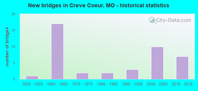
- New bridges - historical statistics
- 11950-1959
- 171960-1969
- 21970-1979
- 21980-1989
- 31990-1999
- 102000-2009
- 72010-2019
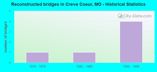
- Reconstructed bridges - Historical Statistics
- 11970-1979
- 11980-1989
- 41990-1999
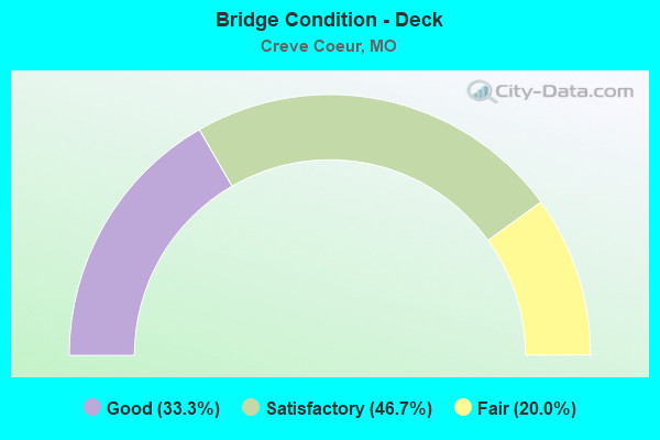
- Bridge Condition - Deck
- 33.3%Good
- 46.7%Satisfactory
- 20.0%Fair
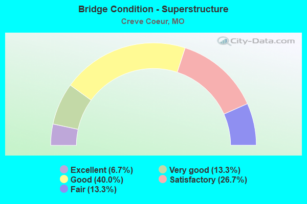
- Bridge Condition - Superstructure
- 6.7%Excellent
- 13.3%Very good
- 40.0%Good
- 26.7%Satisfactory
- 13.3%Fair
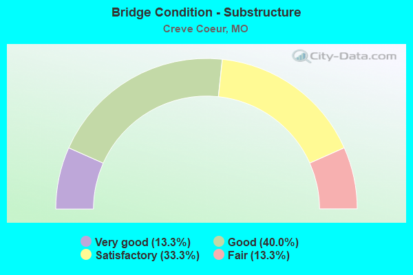
- Bridge Condition - Substructure
- 13.3%Very good
- 40.0%Good
- 33.3%Satisfactory
- 13.3%Fair
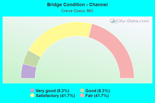
- Bridge Condition - Channel
- 8.3%Very good
- 8.3%Good
- 41.7%Satisfactory
- 41.7%Fair
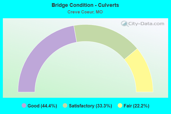
- Bridge Condition - Culverts
- 44.4%Good
- 33.3%Satisfactory
- 22.2%Fair
Find on map >> Show street view
Structure Number: 1023, Location: S 69 T 46 N R 5 E (Lat: 38.727333, Lng: -90.444778), Route carried "on" structure: Interstate 270, Year Built: 1965, Status: Open, Structure Length: 1.17m (3.84ft), Average Daily Traffic: 135,094 (year 2021), Truck Traffic: 12%, Average Future Daily Traffic: 168,868 (year 2041), Design Load: HS 20, Features Intersected: FEE FEE CR BR
Minimum Vertical Clearance: 30+ m (98+ ft), Kilometerpoint: 30.045, Lanes on structure: 10, Base Highway Network: Yes, Owner: State Highway Agency, Approaching Roadway Width: 40.2m (131.9ft), Skew: 20 degrees, Material/Design: Concrete continuous, Design/Construction: Culvert, Number Of Spans In Main Unit: 3, Length of Maximum Span: 3.7m (12.1ft)
Condition: Channel: Fair, Culverts: Satisfactory, Operating Rating: 87.3 metric tons, Method Used To Determine Operating Rating: Field evaluation and documented engineering judgment, Inventory Rating: 52.2 metric tons, Method Used To Determine Inventory Rating: Field evaluation and documented engineering judgment, Structural Evaluation: Equal to present minimum criteria, Waterway Adequacy: Equal to present desirable criteria, Approach Roadway Alignment: Equal to present desirable criteria, Designated Inspection Frequency: Every 24 months, Inspection Date: November 2021
Find on map >> Show street view
Structure Number: 1024, Location: S 3069 T 46 N R 5 E (Lat: 38.726178, Lng: -90.444811), Route carried "on" structure: Interstate 270, Year Built: 1965, Year Reconstructed: 1984, Status: Open, Structure Length: 10.03m (32.91ft), Average Daily Traffic: 135,094 (year 2021), Truck Traffic: 12%, Average Future Daily Traffic: 168,868 (year 2041), Design Load: HS 20+Mod, Features Intersected: UP RR, FEE FEE CR
Minimum Vertical Clearance: 30+ m (98+ ft), Kilometerpoint: 30.138, Lanes on structure: 10, Base Highway Network: Yes, Owner: State Highway Agency, Approaching Roadway Width: 39.0m (128.0ft), Skew: 24 degrees, Material/Design: Steel continuous, Design/Construction: Stringer/Multi-beam, Number Of Spans In Main Unit: 5, Length of Maximum Span: 21.9m (71.9ft), Curb or Sidewalk Widths: Left: 0.2m (0.7ft), Right: 0.2m (0.7ft), Curb-To-Curb Width: 45.0m (147.6ft), Out-to-Out Width: 46.7m (153.2ft)
Condition: Deck: Good, Superstructure: Good, Substructure: Satisfactory, Channel: Satisfactory, Operating Rating: 63.0 metric tons, Method Used To Determine Operating Rating: Load Factor (LF), Inventory Rating: 37.8 metric tons, Method Used To Determine Inventory Rating: Load Factor (LF), Structural Evaluation: Equal to present minimum criteria, Deck Geometry: Superior to present desirable criteria, Underclear: Equal to present minimum criteria, Waterway Adequacy: Equal to present minimum criteria, Approach Roadway Alignment: Equal to present desirable criteria, Designated Inspection Frequency: Every 24 months, Inspection Date: August 2020, Deck Structure Type: Concrete Cast-file-Place, Wearing Surface/Protective System: Wearing Surface: Latex Concrete, Deck Protection: Epoxy Coated Reinforcing
Find on map >> Show street view
Structure Number: 1025, Location: S 1312 T 46 N R 5 E (Lat: 38.698197, Lng: -90.450647), Route carried "on" structure: State highway 364, Year Built: 1966, Year Reconstructed: 2001, Status: Posted for load, Structure Length: 7.80m (25.59ft), Average Daily Traffic: 31,080 (year 2021), Truck Traffic: 5%, Average Future Daily Traffic: 38,850 (year 2041), Design Load: HS 20, Features Intersected: IS 270
Minimum Vertical Clearance: 30+ m (98+ ft), Kilometerpoint: 33.931, Lanes on structure: 5, Lanes under structure: 10, Base Highway Network: Yes, Owner: State Highway Agency, Approaching Roadway Width: 19.8m (65.0ft), Skew: 1 degrees, Material/Design: Steel continuous, Design/Construction: Stringer/Multi-beam, Number Of Spans In Main Unit: 4, Length of Maximum Span: 23.2m (76.1ft), Curb-To-Curb Width: 20.0m (65.6ft), Out-to-Out Width: 20.8m (68.2ft)
Condition: Deck: Fair, Superstructure: Satisfactory, Substructure: Fair, Operating Rating: 68.4 metric tons, Method Used To Determine Operating Rating: Load Factor (LF), Inventory Rating: 41.4 metric tons, Method Used To Determine Inventory Rating: Load Factor (LF), Structural Evaluation: Somewhat better than minimum adequacy, Deck Geometry: Meets minimum limits, Underclear: High priority of corrective action, Approach Roadway Alignment: Equal to present desirable criteria, Designated Inspection Frequency: Every 24 months, Inspection Date: September 2020, Deck Structure Type: Concrete Cast-file-Place, Wearing Surface/Protective System: Wearing Surface: Other
Find on map >> Show street view
Structure Number: 1026, Location: S 1312 T 46 N R 5 E (Lat: 38.698331, Lng: -90.450653), Route carried "on" structure: State highway 364, Year Built: 1966, Year Reconstructed: 2001, Status: Posted for load, Structure Length: 7.80m (25.59ft), Average Daily Traffic: 35,422 (year 2021), Truck Traffic: 5%, Average Future Daily Traffic: 44,278 (year 2041), Design Load: HS 20, Features Intersected: IS 270
Minimum Vertical Clearance: 30+ m (98+ ft), Kilometerpoint: 0.370, Lanes on structure: 4, Lanes under structure: 10, Base Highway Network: Yes, Owner: State Highway Agency, Approaching Roadway Width: 19.8m (65.0ft), Skew: 1 degrees, Material/Design: Steel continuous, Design/Construction: Stringer/Multi-beam, Number Of Spans In Main Unit: 4, Length of Maximum Span: 23.2m (76.1ft), Curb-To-Curb Width: 20.0m (65.6ft), Out-to-Out Width: 20.8m (68.2ft)
Condition: Deck: Fair, Superstructure: Good, Substructure: Fair, Operating Rating: 68.4 metric tons, Method Used To Determine Operating Rating: Load Factor (LF), Inventory Rating: 40.5 metric tons, Method Used To Determine Inventory Rating: Load Factor (LF), Structural Evaluation: Somewhat better than minimum adequacy, Deck Geometry: Equal to present minimum criteria, Underclear: High priority of corrective action, Approach Roadway Alignment: Equal to present desirable criteria, Designated Inspection Frequency: Every 24 months, Inspection Date: September 2020, Deck Structure Type: Concrete Cast-file-Place, Wearing Surface/Protective System: Wearing Surface: Other
Find on map >> Show street view
Structure Number: 1042, Location: S 357 T 46 N R 5 E (Lat: 38.699478, Lng: -90.425892), Route carried "on" structure: State highway D, Year Built: 1966, Status: Open, Structure Length: 0.90m (2.95ft), Average Daily Traffic: 60,878 (year 2021), Truck Traffic: 5%, Average Future Daily Traffic: 76,098 (year 2041), Design Load: HS 20, Features Intersected: FEE FEE CR
Minimum Vertical Clearance: 30+ m (98+ ft), Kilometerpoint: 2.612, Lanes on structure: 4, Base Highway Network: Yes, Owner: State Highway Agency, Approaching Roadway Width: 18.3m (60.0ft), Skew: 21 degrees, Material/Design: Concrete continuous, Design/Construction: Culvert, Number Of Spans In Main Unit: 2, Length of Maximum Span: 4.3m (14.1ft)
Condition: Channel: Fair, Culverts: Fair, Operating Rating: 73.8 metric tons, Method Used To Determine Operating Rating: Load Factor (LF), Inventory Rating: 44.1 metric tons, Method Used To Determine Inventory Rating: Load Factor (LF), Structural Evaluation: Somewhat better than minimum adequacy, Waterway Adequacy: Equal to present desirable criteria, Approach Roadway Alignment: Equal to present desirable criteria, Designated Inspection Frequency: Every 24 months, Inspection Date: November 2021
Find on map >> Show street view
Structure Number: 1043, Location: S 27 T 46 N R 5 E (Lat: 38.700656, Lng: -90.432350), Route carried "on" structure: State highway D, Year Built: 1966, Status: Open, Structure Length: 0.81m (2.66ft), Average Daily Traffic: 60,878 (year 2021), Truck Traffic: 5%, Average Future Daily Traffic: 76,098 (year 2041), Design Load: HS 20, Features Intersected: FEE FEE CR
Minimum Vertical Clearance: 30+ m (98+ ft), Kilometerpoint: 2.045, Lanes on structure: 8, Base Highway Network: Yes, Owner: State Highway Agency, Approaching Roadway Width: 18.3m (60.0ft), Skew: 23 degrees, Material/Design: Concrete continuous, Design/Construction: Culvert, Number Of Spans In Main Unit: 2, Length of Maximum Span: 3.4m (11.2ft)
Condition: Channel: Satisfactory, Culverts: Fair, Operating Rating: 64.8 metric tons, Method Used To Determine Operating Rating: Load Factor (LF), Inventory Rating: 38.7 metric tons, Method Used To Determine Inventory Rating: Load Factor (LF), Structural Evaluation: Somewhat better than minimum adequacy, Waterway Adequacy: Equal to present desirable criteria, Approach Roadway Alignment: Equal to present minimum criteria, Designated Inspection Frequency: Every 24 months, Inspection Date: November 2021
Find on map >> Show street view
Structure Number: 1312, Location: S 32 T 46 N R 5 E (Lat: 38.682217, Lng: -90.488386), Route carried "on" structure: State highway 340, Year Built: 1968, Year Reconstructed: 1991, Status: Posted for load, Structure Length: 5.67m (18.60ft), Average Daily Traffic: 24,403 (year 2021), Truck Traffic: 7%, Average Future Daily Traffic: 34,164 (year 2041), Design Load: HS 20, Features Intersected: CREVE COEUR CR
Minimum Vertical Clearance: 30+ m (98+ ft), Kilometerpoint: 14.812, Lanes on structure: 5, Base Highway Network: Yes, Owner: State Highway Agency, Approaching Roadway Width: 19.5m (64.0ft), Skew: 23 degrees, Material/Design: Steel continuous, Design/Construction: Stringer/Multi-beam, Number Of Spans In Main Unit: 3, Length of Maximum Span: 21.3m (69.9ft), Curb or Sidewalk Widths: Left: 0.0m, Right: 1.2m (3.9ft), Curb-To-Curb Width: 21.3m (69.9ft), Out-to-Out Width: 23.9m (78.4ft)
Condition: Deck: Satisfactory, Superstructure: Satisfactory, Substructure: Satisfactory, Channel: Satisfactory, Operating Rating: 53.1 metric tons, Method Used To Determine Operating Rating: Load Factor (LF), Inventory Rating: 31.5 metric tons, Method Used To Determine Inventory Rating: Load Factor (LF), Structural Evaluation: Equal to present minimum criteria, Deck Geometry: Somewhat better than minimum adequacy, Waterway Adequacy: Equal to present minimum criteria, Approach Roadway Alignment: Equal to present desirable criteria, Designated Inspection Frequency: Every 24 months, Inspection Date: October 2020, Deck Structure Type: Concrete Cast-file-Place, Wearing Surface/Protective System: Wearing Surface: Low Slump Concrete
Find on map >> Show street view
Structure Number: 15569, Location: S 33 T 46 N R 5 E (Lat: 38.685619, Lng: -90.457264), Route carried "on" structure: County highway , Year Built: 1958, Status: Posted for load, Structure Length: 0.88m (2.89ft), Average Daily Traffic: 7,027 (year 2020), Truck Traffic: 1%, Average Future Daily Traffic: 9,486 (year 2040), Design Load: HS 20, Features Intersected: BR OF CREVE COEUR, Facility Carried by Structure: ROSS AVE
Minimum Vertical Clearance: 30+ m (98+ ft), Kilometerpoint: 0.000, Lanes on structure: 2, Owner: County Highway Agency, Approaching Roadway Width: 7.0m (23.0ft), Material/Design: Prestressed concrete, Design/Construction: Box Beam or Girders - Multiple, Number Of Spans In Main Unit: 1, Length of Maximum Span: 7.6m (24.9ft), Curb or Sidewalk Widths: Left: 1.2m (3.9ft), Right: 0.0m, Curb-To-Curb Width: 7.1m (23.3ft), Out-to-Out Width: 7.4m (24.3ft)
Condition: Deck: Fair, Superstructure: Fair, Substructure: Satisfactory, Channel: Fair, Operating Rating: 65.7 metric tons, Method Used To Determine Operating Rating: Allowable Stress (AS), Inventory Rating: 39.6 metric tons, Method Used To Determine Inventory Rating: Allowable Stress (AS), Structural Evaluation: Somewhat better than minimum adequacy, Deck Geometry: High priority of replacement, Waterway Adequacy: Equal to present minimum criteria, Approach Roadway Alignment: Equal to present desirable criteria, Length Of Structure Improvement: 0.15m (0.49ft), Designated Inspection Frequency: Every 24 months, Inspection Date: March 2021, Bridge Improvement Cost: $128,000, Roadway Improvement Cost: $13,000, Total Project Cost: $192,000 ( Estimate for 2022), Deck Structure Type: Other, Wearing Surface/Protective System: Wearing Surface: Bituminous
Find on map >> Show street view
Structure Number: 15682, Location: S 32 T 46 N R 5 E (Lat: 38.688603, Lng: -90.474503), Route carried "on" structure: County highway , Year Built: 1981, Status: Posted for load, Structure Length: 0.70m (2.30ft), Average Daily Traffic: 25,920 (year 2020), Truck Traffic: 5%, Average Future Daily Traffic: 34,992 (year 2040), Design Load: HS 20, Features Intersected: CREVE COEUR CR TRI, Facility Carried by Structure: FEE FEE RD
Minimum Vertical Clearance: 30+ m (98+ ft), Kilometerpoint: 0.000, Lanes on structure: 4, Owner: County Highway Agency, Approaching Roadway Width: 14.6m (47.9ft), Material/Design: Concrete, Design/Construction: Culvert, Number Of Spans In Main Unit: 2, Length of Maximum Span: 3.4m (11.2ft), Curb or Sidewalk Widths: Left: 1.8m (5.9ft), Right: 1.8m (5.9ft)
Condition: Channel: Satisfactory, Culverts: Satisfactory, Operating Rating: 89.1 metric tons, Method Used To Determine Operating Rating: Allowable Stress (AS), Inventory Rating: 45.0 metric tons, Method Used To Determine Inventory Rating: Allowable Stress (AS), Structural Evaluation: Equal to present minimum criteria, Waterway Adequacy: Superior to present desirable criteria, Approach Roadway Alignment: Equal to present desirable criteria, Designated Inspection Frequency: Every 24 months, Inspection Date: April 2020
Find on map >> Show street view
Structure Number: 15858, Location: S 16 T 45 N R 5 E (Lat: 38.648144, Lng: -90.470328), Route carried "on" structure: City street , Year Built: 1996, Status: Open, Structure Length: 1.15m (3.77ft), Average Daily Traffic: 3,600 (year 2020), Truck Traffic: 1%, Average Future Daily Traffic: 4,860 (year 2040), Design Load: HS 20, Features Intersected: SMITH CR, Facility Carried by Structure: CONWAY RD
Minimum Vertical Clearance: 30+ m (98+ ft), Kilometerpoint: 0.322, Lanes on structure: 2, Owner: City or Municipal Highway Agency, Approaching Roadway Width: 7.6m (24.9ft), Skew: 1 degrees, Material/Design: Concrete, Design/Construction: Culvert, Number Of Spans In Main Unit: 2, Length of Maximum Span: 5.6m (18.4ft), Curb-To-Curb Width: 12.0m (39.4ft), Out-to-Out Width: 18.1m (59.4ft)
Condition: Channel: Satisfactory, Culverts: Good, Operating Rating: 54.0 metric tons, Method Used To Determine Operating Rating: Field evaluation and documented engineering judgment, Inventory Rating: 32.4 metric tons, Method Used To Determine Inventory Rating: Field evaluation and documented engineering judgment, Structural Evaluation: Better than present minimum criteria, Deck Geometry: Somewhat better than minimum adequacy, Waterway Adequacy: Superior to present desirable criteria, Approach Roadway Alignment: Equal to present desirable criteria, Designated Inspection Frequency: Every 24 months, Inspection Date: December 2021
Find on map >> Show street view
Structure Number: 15859, Location: S 10 T 45 N R 5 E (Lat: 38.655456, Lng: -90.437306), Route carried "on" structure: City street , Year Built: 1989, Status: Open, Structure Length: 0.88m (2.89ft), Average Daily Traffic: 11,750 (year 2020), Truck Traffic: 1%, Average Future Daily Traffic: 15,863 (year 2040), Features Intersected: DEER CR, Facility Carried by Structure: LADUE RD
Minimum Vertical Clearance: 30+ m (98+ ft), Kilometerpoint: 0.483, Lanes on structure: 2, Owner: City or Municipal Highway Agency, Approaching Roadway Width: 11.9m (39.0ft), Material/Design: Concrete, Design/Construction: Culvert, Number Of Spans In Main Unit: 2, Length of Maximum Span: 2.4m (7.9ft)
Condition: Channel: Very good, Culverts: Satisfactory, Operating Rating: 49.5 metric tons, Method Used To Determine Operating Rating: Allowable Stress (AS), Inventory Rating: 32.4 metric tons, Method Used To Determine Inventory Rating: Allowable Stress (AS), Structural Evaluation: Equal to present minimum criteria, Waterway Adequacy: Superior to present desirable criteria, Approach Roadway Alignment: Equal to present desirable criteria, Designated Inspection Frequency: Every 24 months, Inspection Date: December 2021
Find on map >> Show street view
Structure Number: 15887, Location: S 1923 T 45 N R 5 E (Lat: 38.670761, Lng: -90.474364), Route carried "on" structure: City street , Year Built: 1970, Status: Posted for load, Structure Length: 0.70m (2.30ft), Average Daily Traffic: 550 (year 2020), Truck Traffic: 1%, Average Future Daily Traffic: 743 (year 2040), Design Load: H 10, Features Intersected: SMITH CR, Facility Carried by Structure: BELLERIVE EST DR
Minimum Vertical Clearance: 30+ m (98+ ft), Kilometerpoint: 1.287, Lanes on structure: 2, Owner: City or Municipal Highway Agency, Approaching Roadway Width: 6.7m (22.0ft), Material/Design: Concrete, Design/Construction: Culvert, Number Of Spans In Main Unit: 2, Length of Maximum Span: 3.0m (9.8ft)
Condition: Channel: Fair, Culverts: Good, Operating Rating: 35.1 metric tons, Method Used To Determine Operating Rating: Allowable Stress (AS), Inventory Rating: 22.5 metric tons, Method Used To Determine Inventory Rating: Allowable Stress (AS), Structural Evaluation: Equal to present minimum criteria, Waterway Adequacy: Better than present minimum criteria, Approach Roadway Alignment: Equal to present minimum criteria, Designated Inspection Frequency: Every 24 months, Inspection Date: December 2021
Find on map >> Show street view
Structure Number: 15889, Location: S 730 T 45 N R 5 E (Lat: 38.670922, Lng: -90.477658), Route carried "on" structure: City street , Year Built: 1970, Status: Posted for load, Structure Length: 0.67m (2.20ft), Average Daily Traffic: 950 (year 2020), Truck Traffic: 1%, Average Future Daily Traffic: 1,283 (year 2040), Design Load: H 10, Features Intersected: SMITH CR, Facility Carried by Structure: RUE DE FLEUR DR
Minimum Vertical Clearance: 30+ m (98+ ft), Kilometerpoint: 11.426, Lanes on structure: 2, Owner: City or Municipal Highway Agency, Approaching Roadway Width: 7.9m (25.9ft), Material/Design: Concrete, Design/Construction: Culvert, Number Of Spans In Main Unit: 2, Length of Maximum Span: 2.7m (8.9ft)
Condition: Channel: Fair, Culverts: Good, Operating Rating: 35.1 metric tons, Method Used To Determine Operating Rating: Allowable Stress (AS), Inventory Rating: 22.5 metric tons, Method Used To Determine Inventory Rating: Allowable Stress (AS), Structural Evaluation: Equal to present minimum criteria, Waterway Adequacy: Better than present minimum criteria, Approach Roadway Alignment: Equal to present desirable criteria, Designated Inspection Frequency: Every 24 months, Inspection Date: December 2021
Find on map >> Show street view
Structure Number: 29102, Location: S 3 T 45 N R 5 E (Lat: 38.672136, Lng: -90.449175), Route carried "on" structure: State highway 340, Year Built: 2002, Status: Open, Structure Length: 4.39m (14.40ft), Average Daily Traffic: 32,927 (year 2021), Truck Traffic: 7%, Average Future Daily Traffic: 46,098 (year 2041), Design Load: HS 20+Mod, Features Intersected: IS 270
Minimum Vertical Clearance: 30+ m (98+ ft), Kilometerpoint: 18.488, Lanes on structure: 12, Lanes under structure: 8, Base Highway Network: Yes, Owner: State Highway Agency, Approaching Roadway Width: 65.6m (215.2ft), Skew: 21 degrees, Material/Design: Prestressed concrete continuous, Design/Construction: Stringer/Multi-beam, Number Of Spans In Main Unit: 2, Length of Maximum Span: 21.6m (70.9ft), Curb-To-Curb Width: 65.6m (215.2ft), Out-to-Out Width: 66.4m (217.8ft)
Condition: Deck: Satisfactory, Superstructure: Good, Substructure: Good, Operating Rating: 82.8 metric tons, Method Used To Determine Operating Rating: Load Factor (LF), Inventory Rating: 50.4 metric tons, Method Used To Determine Inventory Rating: Load Factor (LF), Structural Evaluation: Better than present minimum criteria, Deck Geometry: Superior to present desirable criteria, Underclear: High priority of corrective action, Approach Roadway Alignment: Equal to present desirable criteria, Designated Inspection Frequency: Every 24 months, Inspection Date: October 2020, Deck Structure Type: Concrete Cast-file-Place, Wearing Surface/Protective System: Wearing Surface: Monolithic Concrete, Deck Protection: Epoxy Coated Reinforcing
Find on map >> Show street view
Structure Number: 29108, Location: S 3 T 45 N R 5 E (Lat: 38.672486, Lng: -90.450822), Route carried "on" structure: State highway 340, Year Built: 2002, Status: Open, Structure Length: 2.19m (7.19ft), Average Daily Traffic: 27,678 (year 2021), Truck Traffic: 7%, Average Future Daily Traffic: 38,749 (year 2041), Design Load: HS 20+Mod, Features Intersected: CST WOODCREST EXECUTIVE
Minimum Vertical Clearance: 30+ m (98+ ft), Kilometerpoint: 18.356, Lanes on structure: 10, Lanes under structure: 2, Base Highway Network: Yes, Owner: State Highway Agency, Approaching Roadway Width: 40.0m (131.2ft), Skew: 23 degrees, Material/Design: Prestressed concrete, Design/Construction: Stringer/Multi-beam, Number Of Spans In Main Unit: 1, Length of Maximum Span: 20.9m (68.6ft), Curb or Sidewalk Widths: Left: 2.2m (7.2ft), Right: 2.2m (7.2ft), Curb-To-Curb Width: 35.6m (116.8ft), Out-to-Out Width: 40.0m (131.2ft)
Condition: Deck: Satisfactory, Superstructure: Satisfactory, Substructure: Good, Operating Rating: 85.5 metric tons, Method Used To Determine Operating Rating: Load Factor (LF), Inventory Rating: 51.3 metric tons, Method Used To Determine Inventory Rating: Load Factor (LF), Structural Evaluation: Equal to present minimum criteria, Deck Geometry: High priority of corrective action, Underclear: Somewhat better than minimum adequacy, Approach Roadway Alignment: Equal to present desirable criteria, Length Of Structure Improvement: 0.30m (0.98ft), Designated Inspection Frequency: Every 24 months, Inspection Date: October 2020, Bridge Improvement Cost: $920,000, Roadway Improvement Cost: $92,000, Total Project Cost: $1,379,000 ( Estimate for 2022), Deck Structure Type: Concrete Cast-file-Place, Wearing Surface/Protective System: Wearing Surface: Monolithic Concrete, Deck Protection: Epoxy Coated Reinforcing
Find on map >> Show street view
Structure Number: 29634, Location: S 1 T 45 N R 5 E (Lat: 38.673169, Lng: -90.404769), Route carried "on" structure: State highway 340, Year Built: 2003, Status: Open, Structure Length: 6.10m (20.01ft), Average Daily Traffic: 28,008 (year 2021), Truck Traffic: 5%, Average Future Daily Traffic: 39,211 (year 2041), Design Load: HS 20+Mod, Features Intersected: US 67
Minimum Vertical Clearance: 30+ m (98+ ft), Kilometerpoint: 22.473, Lanes on structure: 6, Lanes under structure: 6, Base Highway Network: Yes, Owner: State Highway Agency, Approaching Roadway Width: 14.6m (47.9ft), Skew: 30 degrees, Material/Design: Prestressed concrete continuous, Design/Construction: Slab, Number Of Spans In Main Unit: 4, Length of Maximum Span: 15.8m (51.8ft), Curb or Sidewalk Widths: Left: 0.4m (1.3ft), Right: 0.4m (1.3ft), Curb-To-Curb Width: 25.4m (83.3ft), Out-to-Out Width: 30.5m (100.1ft)
Condition: Deck: Satisfactory, Superstructure: Satisfactory, Substructure: Good, Operating Rating: 55.8 metric tons, Method Used To Determine Operating Rating: Load Factor (LF), Inventory Rating: 33.3 metric tons, Method Used To Determine Inventory Rating: Load Factor (LF), Structural Evaluation: Equal to present minimum criteria, Deck Geometry: Somewhat better than minimum adequacy, Underclear: Equal to present minimum criteria, Approach Roadway Alignment: Equal to present desirable criteria, Designated Inspection Frequency: Every 24 months, Inspection Date: October 2020, Deck Structure Type: Concrete Cast-file-Place, Wearing Surface/Protective System: Wearing Surface: Monolithic Concrete, Deck Protection: Epoxy Coated Reinforcing
Find on map >> Show street view
Structure Number: 30337, Location: S 25 T 46 N R 5 E (Lat: 38.697300, Lng: -90.414014), Route carried "on" structure: State highway D, Year Built: 2004, Status: Open, Structure Length: 8.92m (29.27ft), Average Daily Traffic: 30,723 (year 2021), Truck Traffic: 5%, Average Future Daily Traffic: 38,404 (year 2041), Design Load: HS 20, Features Intersected: UP RR
Minimum Vertical Clearance: 30+ m (98+ ft), Kilometerpoint: 3.605, Lanes on structure: 3, Base Highway Network: Yes, Owner: State Highway Agency, Approaching Roadway Width: 16.0m (52.5ft), Skew: 5 degrees, Material/Design: Steel continuous, Design/Construction: Stringer/Multi-beam, Number Of Spans In Main Unit: 3, Length of Maximum Span: 37.8m (124.0ft), Curb-To-Curb Width: 16.0m (52.5ft), Out-to-Out Width: 16.9m (55.4ft)
Condition: Deck: Satisfactory, Superstructure: Good, Substructure: Good, Operating Rating: 90.9 metric tons, Method Used To Determine Operating Rating: Load Factor (LF), Inventory Rating: 54.9 metric tons, Method Used To Determine Inventory Rating: Load Factor (LF), Structural Evaluation: Better than present minimum criteria, Deck Geometry: Equal to present minimum criteria, Underclear: Equal to present desirable criteria, Approach Roadway Alignment: Better than present minimum criteria, Designated Inspection Frequency: Every 24 months, Inspection Date: September 2020, Deck Structure Type: Concrete Cast-file-Place, Wearing Surface/Protective System: Wearing Surface: Monolithic Concrete, Deck Protection: Epoxy Coated Reinforcing
Find on map >> Show street view
Structure Number: 30338, Location: S 25 T 46 N R 5 E (Lat: 38.697486, Lng: -90.414294), Route carried "on" structure: State highway D, Year Built: 2004, Status: Open, Structure Length: 8.92m (29.27ft), Average Daily Traffic: 30,155 (year 2021), Truck Traffic: 5%, Average Future Daily Traffic: 37,694 (year 2041), Design Load: HS 20, Features Intersected: UP RR
Minimum Vertical Clearance: 30+ m (98+ ft), Kilometerpoint: 21.607, Lanes on structure: 3, Base Highway Network: Yes, Owner: State Highway Agency, Approaching Roadway Width: 16.0m (52.5ft), Skew: 5 degrees, Material/Design: Steel continuous, Design/Construction: Stringer/Multi-beam, Number Of Spans In Main Unit: 3, Length of Maximum Span: 37.8m (124.0ft), Curb-To-Curb Width: 16.0m (52.5ft), Out-to-Out Width: 16.9m (55.4ft)
Condition: Deck: Good, Superstructure: Very good, Substructure: Good, Operating Rating: 90.9 metric tons, Method Used To Determine Operating Rating: Load Factor (LF), Inventory Rating: 54.9 metric tons, Method Used To Determine Inventory Rating: Load Factor (LF), Structural Evaluation: Better than present minimum criteria, Deck Geometry: Equal to present minimum criteria, Underclear: Equal to present desirable criteria, Approach Roadway Alignment: Better than present minimum criteria, Designated Inspection Frequency: Every 24 months, Inspection Date: September 2020, Deck Structure Type: Concrete Cast-file-Place, Wearing Surface/Protective System: Wearing Surface: Monolithic Concrete, Deck Protection: Epoxy Coated Reinforcing
Find on map >> Show street view
Structure Number: 32979, Location: S 28 T 46 N R 5 E (Lat: 38.700350, Lng: -90.450531), Route carried "on" structure: Ramp State highway , Year Built: 2010, Status: Open, Structure Length: 4.74m (15.55ft), Average Daily Traffic: 7,198 (year 2021), Truck Traffic: 7%, Average Future Daily Traffic: 8,998 (year 2041), Design Load: HS 20+Mod, Features Intersected: IS 270, Facility Carried by Structure: RP IS270E TO MO364
Minimum Vertical Clearance: 5.19m (17.03ft), Kilometerpoint: 0.875, Lanes on structure: 3, Lanes under structure: 8, Base Highway Network: Yes, Owner: State Highway Agency, Approaching Roadway Width: 17.1m (56.1ft), Material/Design: Steel, Design/Construction: Stringer/Multi-beam, Number Of Spans In Main Unit: 1, Length of Maximum Span: 46.3m (151.9ft), Curb-To-Curb Width: 17.1m (56.1ft), Out-to-Out Width: 17.9m (58.7ft)
Condition: Deck: Good, Superstructure: Very good, Substructure: Very good, Operating Rating: 63.9 metric tons, Method Used To Determine Operating Rating: Load Factor (LF), Inventory Rating: 38.7 metric tons, Method Used To Determine Inventory Rating: Load Factor (LF), Structural Evaluation: Equal to present desirable criteria, Deck Geometry: Superior to present desirable criteria, Underclear: High priority of corrective action, Approach Roadway Alignment: Equal to present desirable criteria, Designated Inspection Frequency: Every 24 months, Inspection Date: October 2020, Deck Structure Type: Concrete Cast-file-Place, Wearing Surface/Protective System: Wearing Surface: Monolithic Concrete, Deck Protection: Epoxy Coated Reinforcing
Find on map >> Show street view
Structure Number: 32981, Location: S 28 T 46 N R 5 E (Lat: 38.698781, Lng: -90.447922), Route carried "on" structure: Ramp State highway , Year Built: 2010, Status: Open, Structure Length: 4.63m (15.19ft), Average Daily Traffic: 13,743 (year 2021), Truck Traffic: 18%, Average Future Daily Traffic: 17,179 (year 2041), Design Load: HS 20+Mod, Features Intersected: MO 364, Facility Carried by Structure: RP IS270E TO MO364
Minimum Vertical Clearance: 5.23m (17.16ft), Kilometerpoint: 0.579, Lanes on structure: 2, Lanes under structure: 8, Base Highway Network: Yes, Owner: State Highway Agency, Approaching Roadway Width: 11.6m (38.1ft), Skew: 1 degrees, Material/Design: Steel, Design/Construction: Stringer/Multi-beam, Number Of Spans In Main Unit: 1, Length of Maximum Span: 46.3m (151.9ft), Curb-To-Curb Width: 11.6m (38.1ft), Out-to-Out Width: 12.4m (40.7ft)
Condition: Deck: Good, Superstructure: Excellent, Substructure: Very good, Operating Rating: 81.0 metric tons, Method Used To Determine Operating Rating: Load Factor (LF), Inventory Rating: 48.6 metric tons, Method Used To Determine Inventory Rating: Load Factor (LF), Structural Evaluation: Equal to present desirable criteria, Deck Geometry: Superior to present desirable criteria, Underclear: High priority of corrective action, Approach Roadway Alignment: Better than present minimum criteria, Designated Inspection Frequency: Every 24 months, Inspection Date: October 2020, Deck Structure Type: Concrete Cast-file-Place, Wearing Surface/Protective System: Wearing Surface: Monolithic Concrete, Deck Protection: Epoxy Coated Reinforcing
Find on map >> Show street view
Structure Number: 36246, Location: S 8 T 45 N R 5 E (Lat: 38.655550, Lng: -90.474669), Route carried "on" structure: State highway AB, Year Built: 2019, Status: Open, Structure Length: 1.13m (3.71ft), Average Daily Traffic: 8,701 (year 2021), Truck Traffic: 4%, Average Future Daily Traffic: 12,181 (year 2041), Features Intersected: HIBLER CR
Minimum Vertical Clearance: 30+ m (98+ ft), Kilometerpoint: 2.834, Lanes on structure: 2, Owner: State Highway Agency, Approaching Roadway Width: 9.8m (32.2ft), Skew: 4 degrees, Material/Design: Concrete, Design/Construction: Culvert, Number Of Spans In Main Unit: 1, Length of Maximum Span: 7.9m (25.9ft), Curb or Sidewalk Widths: Left: 0.0m, Right: 2.1m (6.9ft), Curb-To-Curb Width: 9.8m (32.2ft), Out-to-Out Width: 12.7m (41.7ft)
Condition: Channel: Good, Culverts: Good, Operating Rating: 67.5 metric tons, Method Used To Determine Operating Rating: Load and Resistance Factor (LRFR), Inventory Rating: 40.5 metric tons, Method Used To Determine Inventory Rating: Load and Resistance Factor (LRFR), Structural Evaluation: Better than present minimum criteria, Deck Geometry: Meets minimum limits, Waterway Adequacy: Superior to present desirable criteria, Approach Roadway Alignment: Equal to present desirable criteria, Designated Inspection Frequency: Every 24 months, Inspection Date: November 2021, Deck Structure Type: Concrete Cast-file-Place, Wearing Surface/Protective System: Wearing Surface: Monolithic Concrete, Deck Protection: Epoxy Coated Reinforcing
Find on map >> Show street view
Structure Number: 3752, Location: S 15 T 45 N R 5 E (Lat: 38.638342, Lng: -90.443519), Route carried "on" structure: Ramp State highway , Year Built: 1990, Status: Open, Structure Length: 5.49m (18.01ft), Average Daily Traffic: 14,124 (year 2021), Truck Traffic: 18%, Average Future Daily Traffic: 17,655 (year 2041), Design Load: HS 20+Mod, Features Intersected: RT JJ, Facility Carried by Structure: RP IS270E TO IS64E
Minimum Vertical Clearance: 30+ m (98+ ft), Kilometerpoint: 0.766, Lanes on structure: 3, Lanes under structure: 6, Base Highway Network: Yes, Owner: State Highway Agency, Approaching Roadway Width: 17.1m (56.1ft), Material/Design: Prestressed concrete continuous, Design/Construction: Stringer/Multi-beam, Number Of Spans In Main Unit: 3, Length of Maximum Span: 29.0m (95.1ft), Curb-To-Curb Width: 15.5m (50.9ft), Out-to-Out Width: 16.3m (53.5ft)
Condition: Deck: Good, Superstructure: Fair, Substructure: Good, Operating Rating: 77.4 metric tons, Method Used To Determine Operating Rating: Load Factor (LF), Inventory Rating: 31.5 metric tons, Method Used To Determine Inventory Rating: Load Factor (LF), Structural Evaluation: Somewhat better than minimum adequacy, Deck Geometry: Superior to present desirable criteria, Underclear: Meets minimum limits, Approach Roadway Alignment: Equal to present desirable criteria, Designated Inspection Frequency: Every 24 months, Inspection Date: October 2020, Deck Structure Type: Concrete Cast-file-Place, Wearing Surface/Protective System: Wearing Surface: Monolithic Concrete, Membrane: Other, Deck Protection: Epoxy Coated Reinforcing
Find on map >> Show street view
Structure Number: 848, Location: S 10 T 45 N R 5 E (Lat: 38.655508, Lng: -90.448019), Route carried "on" structure: Interstate 270, Year Built: 1964, Year Reconstructed: 2004, Status: Posted for load, Structure Length: 5.24m (17.19ft), Average Daily Traffic: 87,819 (year 2021), Truck Traffic: 12%, Average Future Daily Traffic: 109,774 (year 2041), Design Load: HS 20+Mod, Features Intersected: RT AB
Minimum Vertical Clearance: 30+ m (98+ ft), Kilometerpoint: 22.259, Lanes on structure: 4, Lanes under structure: 6, Base Highway Network: Yes, Owner: State Highway Agency, Approaching Roadway Width: 19.5m (64.0ft), Material/Design: Steel continuous, Design/Construction: Stringer/Multi-beam, Number Of Spans In Main Unit: 3, Length of Maximum Span: 23.2m (76.1ft), Curb or Sidewalk Widths: Left: 0.2m (0.7ft), Right: 0.2m (0.7ft), Curb-To-Curb Width: 18.9m (62.0ft), Out-to-Out Width: 19.8m (65.0ft)
Condition: Deck: Satisfactory, Superstructure: Good, Substructure: Satisfactory, Operating Rating: 51.3 metric tons, Method Used To Determine Operating Rating: Load Factor (LF), Inventory Rating: 30.6 metric tons, Method Used To Determine Inventory Rating: Load Factor (LF), Structural Evaluation: Equal to present minimum criteria, Deck Geometry: Meets minimum limits, Underclear: Equal to present minimum criteria, Approach Roadway Alignment: Equal to present desirable criteria, Designated Inspection Frequency: Every 24 months, Inspection Date: October 2020, Deck Structure Type: Concrete Cast-file-Place, Wearing Surface/Protective System: Wearing Surface: Bituminous
Find on map >> Show street view
Structure Number: 849, Location: S 10 T 45 N R 5 E (Lat: 38.655519, Lng: -90.448300), Route carried "on" structure: Interstate 270, Year Built: 1964, Year Reconstructed: 2004, Status: Posted for load, Structure Length: 5.24m (17.19ft), Average Daily Traffic: 104,390 (year 2021), Truck Traffic: 12%, Average Future Daily Traffic: 130,488 (year 2041), Design Load: HS 20+Mod, Features Intersected: RT AB
Minimum Vertical Clearance: 30+ m (98+ ft), Kilometerpoint: 35.275, Lanes on structure: 4, Lanes under structure: 6, Base Highway Network: Yes, Owner: State Highway Agency, Approaching Roadway Width: 19.5m (64.0ft), Material/Design: Steel continuous, Design/Construction: Stringer/Multi-beam, Number Of Spans In Main Unit: 3, Length of Maximum Span: 23.2m (76.1ft), Curb or Sidewalk Widths: Left: 0.2m (0.7ft), Right: 0.2m (0.7ft), Curb-To-Curb Width: 18.9m (62.0ft), Out-to-Out Width: 19.8m (65.0ft)
Condition: Deck: Satisfactory, Superstructure: Good, Substructure: Satisfactory, Operating Rating: 51.3 metric tons, Method Used To Determine Operating Rating: Load Factor (LF), Inventory Rating: 30.6 metric tons, Method Used To Determine Inventory Rating: Load Factor (LF), Structural Evaluation: Equal to present minimum criteria, Deck Geometry: Meets minimum limits, Underclear: Somewhat better than minimum adequacy, Approach Roadway Alignment: Equal to present desirable criteria, Designated Inspection Frequency: Every 24 months, Inspection Date: October 2020, Deck Structure Type: Concrete Cast-file-Place, Wearing Surface/Protective System: Wearing Surface: Bituminous
Find on map >> Show street view
Structure Number: 1025, Location: S 1312 T 46 N R 5 E (Lat: 38.698197, Lng: -90.450647), Route carried "under" structure: Interstate 270, Year Built: 1966, Structure Length: 0. m, Average Daily Traffic: 79,446 (year 2021), Truck Traffic: 12%, Features Intersected: IS 270, Facility Carried by Structure: MO 364 E
Minimum Vertical Clearance: 5.11m (16.77ft), Kilometerpoint: 27.031, Lanes on structure: 5, Lanes under structure: 5, Material/Design: Steel continuous, Design/Construction: Stringer/Multi-beam, Length of Maximum Span: 23.2m (76.1ft)
Find on map >> Show street view
Structure Number: 1025, Location: S 1312 T 46 N R 5 E (Lat: 38.698197, Lng: -90.450647), Route carried "under" structure: Interstate 270, Year Built: 1966, Structure Length: 0. m, Average Daily Traffic: 77,666 (year 2021), Truck Traffic: 12%, Features Intersected: IS 270, Facility Carried by Structure: MO 364 E
Minimum Vertical Clearance: 5.06m (16.60ft), Kilometerpoint: 30.561, Lanes on structure: 5, Lanes under structure: 5, Material/Design: Steel continuous, Design/Construction: Stringer/Multi-beam, Length of Maximum Span: 23.2m (76.1ft)
Find on map >> Show street view
Structure Number: 1026, Location: S 1312 T 46 N R 5 E (Lat: 38.698331, Lng: -90.450653), Route carried "under" structure: Interstate 270, Year Built: 1966, Structure Length: 0. m, Average Daily Traffic: 79,446 (year 2021), Truck Traffic: 12%, Features Intersected: IS 270, Facility Carried by Structure: MO 364 W
Minimum Vertical Clearance: 5.20m (17.06ft), Kilometerpoint: 27.055, Lanes on structure: 4, Lanes under structure: 5, Material/Design: Steel continuous, Design/Construction: Stringer/Multi-beam, Length of Maximum Span: 23.2m (76.1ft)
Find on map >> Show street view
Structure Number: 1026, Location: S 1312 T 46 N R 5 E (Lat: 38.698331, Lng: -90.450653), Route carried "under" structure: Interstate 270, Year Built: 1966, Structure Length: 0. m, Average Daily Traffic: 66,888 (year 2021), Truck Traffic: 12%, Features Intersected: IS 270, Facility Carried by Structure: MO 364 W
Minimum Vertical Clearance: 5.20m (17.06ft), Kilometerpoint: 30.536, Lanes on structure: 4, Lanes under structure: 5, Material/Design: Steel continuous, Design/Construction: Stringer/Multi-beam, Length of Maximum Span: 23.2m (76.1ft)
Find on map >> Show street view
Structure Number: 29102, Location: S 3 T 45 N R 5 E (Lat: 38.672136, Lng: -90.449175), Route carried "under" structure: Interstate 270, Year Built: 2002, Structure Length: 0. m, Average Daily Traffic: 77,666 (year 2021), Truck Traffic: 12%, Features Intersected: IS 270, Facility Carried by Structure: MO 340 E
Minimum Vertical Clearance: 5.54m (18.18ft), Kilometerpoint: 33.450, Lanes on structure: 12, Lanes under structure: 4, Material/Design: Prestressed concrete continuous, Design/Construction: Stringer/Multi-beam, Length of Maximum Span: 21.6m (70.9ft)
Find on map >> Show street view
Structure Number: 29102, Location: S 3 T 45 N R 5 E (Lat: 38.672136, Lng: -90.449175), Route carried "under" structure: Interstate 270, Year Built: 2002, Structure Length: 0. m, Average Daily Traffic: 89,340 (year 2021), Truck Traffic: 12%, Features Intersected: IS 270, Facility Carried by Structure: MO 340 E
Minimum Vertical Clearance: 5.59m (18.34ft), Kilometerpoint: 24.129, Lanes on structure: 12, Lanes under structure: 4, Material/Design: Prestressed concrete continuous, Design/Construction: Stringer/Multi-beam, Length of Maximum Span: 21.6m (70.9ft)
Find on map >> Show street view
Structure Number: 29108, Location: S 3 T 45 N R 5 E (Lat: 38.672486, Lng: -90.450822), Route carried "under" structure: City street , Year Built: 2002, Structure Length: 0. m, Average Daily Traffic: 702 (year 2021), Truck Traffic: 10%, Features Intersected: CST WOODCREST EXECUTIVE, Facility Carried by Structure: MO 340 E
Minimum Vertical Clearance: 5.08m (16.67ft), Kilometerpoint: 0.050, Lanes on structure: 10, Lanes under structure: 2, Material/Design: Prestressed concrete, Design/Construction: Stringer/Multi-beam, Length of Maximum Span: 20.9m (68.6ft)
Find on map >> Show street view
Structure Number: 29634, Location: S 1 T 45 N R 5 E (Lat: 38.673169, Lng: -90.404769), Route carried "under" structure: US 67, Year Built: 2003, Structure Length: 0. m, Average Daily Traffic: 12,484 (year 2021), Truck Traffic: 5%, Features Intersected: US 67, Facility Carried by Structure: MO 340 E
Minimum Vertical Clearance: 4.78m (15.68ft), Kilometerpoint: 281.089, Lanes on structure: 6, Lanes under structure: 3, Material/Design: Prestressed concrete continuous, Design/Construction: Slab, Length of Maximum Span: 15.8m (51.8ft)
Find on map >> Show street view
Structure Number: 29634, Location: S 1 T 45 N R 5 E (Lat: 38.673169, Lng: -90.404769), Route carried "under" structure: US 67, Year Built: 2003, Structure Length: 0. m, Average Daily Traffic: 14,797 (year 2021), Truck Traffic: 10%, Features Intersected: US 67, Facility Carried by Structure: MO 340 E
Minimum Vertical Clearance: 4.80m (15.75ft), Kilometerpoint: 37.047, Lanes on structure: 6, Lanes under structure: 3, Material/Design: Prestressed concrete continuous, Design/Construction: Slab, Length of Maximum Span: 15.8m (51.8ft)
Find on map >> Show street view
Structure Number: 32979, Location: S 28 T 46 N R 5 E (Lat: 38.700350, Lng: -90.450531), Route carried "under" structure: Interstate 270, Year Built: 2010, Structure Length: 0. m, Average Daily Traffic: 67,051 (year 2021), Truck Traffic: 12%, Features Intersected: IS 270
Minimum Vertical Clearance: 5.11m (16.77ft), Kilometerpoint: 27.269, Lanes on structure: 3, Lanes under structure: 4, Material/Design: Steel, Design/Construction: Stringer/Multi-beam, Length of Maximum Span: 46.3m (151.9ft)
Find on map >> Show street view
Structure Number: 32979, Location: S 28 T 46 N R 5 E (Lat: 38.700350, Lng: -90.450531), Route carried "under" structure: Interstate 270, Year Built: 2010, Structure Length: 0. m, Average Daily Traffic: 66,888 (year 2021), Truck Traffic: 12%, Features Intersected: IS 270
Minimum Vertical Clearance: 5.11m (16.77ft), Kilometerpoint: 30.317, Lanes on structure: 3, Lanes under structure: 4, Material/Design: Steel, Design/Construction: Stringer/Multi-beam, Length of Maximum Span: 46.3m (151.9ft)
Find on map >> Show street view
Structure Number: 32981, Location: S 28 T 46 N R 5 E (Lat: 38.698781, Lng: -90.447922), Route carried "under" structure: State highway 364, Year Built: 2010, Structure Length: 0. m, Average Daily Traffic: 31,080 (year 2021), Truck Traffic: 5%, Features Intersected: MO 364
Minimum Vertical Clearance: 5.23m (17.16ft), Kilometerpoint: 34.194, Lanes on structure: 2, Lanes under structure: 4, Material/Design: Steel, Design/Construction: Stringer/Multi-beam, Length of Maximum Span: 46.3m (151.9ft)
Find on map >> Show street view
Structure Number: 32981, Location: S 28 T 46 N R 5 E (Lat: 38.698781, Lng: -90.447922), Route carried "under" structure: State highway 364, Year Built: 2010, Structure Length: 0. m, Average Daily Traffic: 35,422 (year 2021), Truck Traffic: 5%, Features Intersected: MO 364
Minimum Vertical Clearance: 5.23m (17.16ft), Kilometerpoint: 0.225, Lanes on structure: 2, Lanes under structure: 4, Material/Design: Steel, Design/Construction: Stringer/Multi-beam, Length of Maximum Span: 46.3m (151.9ft)
Find on map >> Show street view
Structure Number: 3752, Location: S 15 T 45 N R 5 E (Lat: 38.638342, Lng: -90.443519), Route carried "under" structure: State highway JJ, Year Built: 1990, Structure Length: 0. m, Average Daily Traffic: 18,042 (year 2021), Truck Traffic: 5%, Features Intersected: RT JJ, Facility Carried by Structure: RP IS270E TO IS64E
Minimum Vertical Clearance: 5.26m (17.26ft), Kilometerpoint: 0.156, Lanes on structure: 3, Lanes under structure: 6, Material/Design: Prestressed concrete continuous, Design/Construction: Stringer/Multi-beam, Length of Maximum Span: 29.0m (95.1ft)
Find on map >> Show street view
Structure Number: 468, Location: S 25 T 46 N R 5 E (Lat: 38.696369, Lng: -90.408686), Route carried "under" structure: US 67, Year Built: 1961, Structure Length: 0. m, Average Daily Traffic: 14,797 (year 2021), Truck Traffic: 10%, Features Intersected: US 67, Facility Carried by Structure: RT D E
Minimum Vertical Clearance: 4.50m (14.76ft), Kilometerpoint: 34.361, Lanes on structure: 6, Lanes under structure: 3, Material/Design: Concrete continuous, Design/Construction: Slab, Length of Maximum Span: 16.5m (54.1ft)
Find on map >> Show street view
Structure Number: 468, Location: S 25 T 46 N R 5 E (Lat: 38.696369, Lng: -90.408686), Route carried "under" structure: US 67, Year Built: 1961, Structure Length: 0. m, Average Daily Traffic: 13,193 (year 2021), Truck Traffic: 9%, Features Intersected: US 67, Facility Carried by Structure: RT D E
Minimum Vertical Clearance: 4.50m (14.76ft), Kilometerpoint: 283.773, Lanes on structure: 6, Lanes under structure: 3, Material/Design: Concrete continuous, Design/Construction: Slab, Length of Maximum Span: 16.5m (54.1ft)
Find on map >> Show street view
Structure Number: 848, Location: S 10 T 45 N R 5 E (Lat: 38.655508, Lng: -90.448019), Route carried "under" structure: State highway AB, Year Built: 1964, Structure Length: 0. m, Average Daily Traffic: 9,892 (year 2021), Truck Traffic: 4%, Features Intersected: RT AB, Facility Carried by Structure: IS 270 E
Minimum Vertical Clearance: 4.60m (15.09ft), Kilometerpoint: 5.164, Lanes on structure: 4, Lanes under structure: 6, Material/Design: Steel continuous, Design/Construction: Stringer/Multi-beam, Length of Maximum Span: 23.2m (76.1ft)
Find on map >> Show street view
Structure Number: 849, Location: S 10 T 45 N R 5 E (Lat: 38.655519, Lng: -90.448300), Route carried "under" structure: State highway AB, Year Built: 1964, Structure Length: 0. m, Average Daily Traffic: 9,892 (year 2021), Truck Traffic: 4%, Features Intersected: RT AB, Facility Carried by Structure: IS 270 W
Minimum Vertical Clearance: 4.57m (14.99ft), Kilometerpoint: 5.139, Lanes on structure: 4, Lanes under structure: 6, Material/Design: Steel continuous, Design/Construction: Stringer/Multi-beam, Length of Maximum Span: 23.2m (76.1ft)