Bridge Statistics for East Liverpool, Ohio (OH)
Condition, Traffic, Stress, Structural Evaluation, Project Costs
- National Bridge Inventory (NBI) Statistics
- 39Number of bridges
- 938ft / 286mTotal length
- $3,355,840,000Total costs
- 278,772Total average daily traffic
- 28,995Total average daily truck traffic
- National Bridge Inventory (NBI) Registered Bridges for East Liverpool
- No street view available for this location
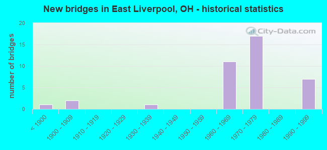
- New bridges - historical statistics
- 1Before 1900
- 21900-1909
- 11930-1939
- 111960-1969
- 171970-1979
- 71990-1999

- Reconstructed bridges - Historical Statistics
- 11950-1959
- 01960-1969
- 01970-1979
- 01980-1989
- 11990-1999


- Bridge Condition - Deck
- 10.0%Very good
- 35.0%Good
- 45.0%Satisfactory
- 5.0%Fair
- 5.0%Poor

- Bridge Condition - Superstructure
- 5.0%Excellent
- 60.0%Good
- 20.0%Satisfactory
- 15.0%Fair

- Bridge Condition - Substructure
- 15.0%Very good
- 35.0%Good
- 35.0%Satisfactory
- 15.0%Fair

- Bridge Condition - Channel
- 25.0%Very good
- 50.0%Satisfactory
- 12.5%Fair
- 12.5%Poor
Find on map >> Show street view
Structure Number: 150009, Location: .39 MI S OF US 30 (Lat: 40.622519, Lng: -80.588250), Route carried "on" structure: State highway 7, Year Built: 1880, Year Reconstructed: 1963, Status: Open, Structure Length: 0.70m (2.30ft), Average Daily Traffic: 11,886 (year 2015), Truck Traffic: 10%, Average Future Daily Traffic: 16,498 (year 2035), Design Load: H 20, Features Intersected: CARPENTER RUN
Minimum Vertical Clearance: 30+ m (98+ ft), Kilometerpoint: 9.576, Lanes on structure: 4, Base Highway Network: Yes, Owner: State Highway Agency, Approaching Roadway Width: 29.3m (96.1ft), Skew: 3 degrees, Material/Design: Concrete, Design/Construction: Culvert, Number Of Spans In Main Unit: 1, Length of Maximum Span: 5.5m (18.0ft), Curb or Sidewalk Widths: Left: 0.0m, Right: 1.5m (4.9ft)
Condition: Channel: Poor, Culverts: Satisfactory, Operating Rating: 42.1 metric tons, Method Used To Determine Operating Rating: Load Factor (LF) rating reported by rating factor (RF) method using MS18 loading, Inventory Rating: 32.4 metric tons, Method Used To Determine Inventory Rating: Load Factor (LF) rating reported by rating factor (RF) method using MS18 loading, Structural Evaluation: Equal to present minimum criteria, Waterway Adequacy: Somewhat better than minimum adequacy, Approach Roadway Alignment: Equal to present desirable criteria, Designated Inspection Frequency: Every 12 months, Inspection Date: March 2021
Find on map >> Show street view
Structure Number: 1502212, Location: 0.60 MI E OF JCT SR 7 (Lat: 40.617511, Lng: -80.582961), Route carried "on" structure: City street M0517, Year Built: 1991, Status: Open, Structure Length: 5.52m (18.11ft), Average Daily Traffic: 5,322 (year 2018), Truck Traffic: 8%, Average Future Daily Traffic: 7,387 (year 2038), Design Load: HS 20+Mod, Features Intersected: USR-30, Facility Carried by Structure: JACKSON STREET
Minimum Vertical Clearance: 30+ m (98+ ft), Kilometerpoint: 0.056, Lanes on structure: 2, Lanes under structure: 4, Base Highway Network: Yes, Owner: State Highway Agency, Approaching Roadway Width: 14.6m (47.9ft), Material/Design: Steel continuous, Design/Construction: Stringer/Multi-beam, Number Of Spans In Main Unit: 2, Length of Maximum Span: 29.0m (95.1ft), Curb or Sidewalk Widths: Left: 1.8m (5.9ft), Right: 1.8m (5.9ft), Curb-To-Curb Width: 14.6m (47.9ft), Out-to-Out Width: 19.0m (62.3ft)
Condition: Deck: Satisfactory, Superstructure: Good, Substructure: Fair, Operating Rating: 42.1 metric tons, Method Used To Determine Operating Rating: Load Factor (LF) rating reported by rating factor (RF) method using MS18 loading, Inventory Rating: 32.4 metric tons, Method Used To Determine Inventory Rating: Load Factor (LF) rating reported by rating factor (RF) method using MS18 loading, Structural Evaluation: Somewhat better than minimum adequacy, Deck Geometry: Superior to present desirable criteria, Underclear: High priority of corrective action, Approach Roadway Alignment: Equal to present desirable criteria, Designated Inspection Frequency: Every 12 months, Inspection Date: April 2021, Deck Structure Type: Concrete Cast-file-Place, Wearing Surface/Protective System: Wearing Surface: Monolithic Concrete, Deck Protection: Epoxy Coated Reinforcing
Find on map >> Show street view
Structure Number: 150222, Location: 0.83 MI W OF W VA ST LINE (Lat: 40.616250, Lng: -80.577111), Route carried "on" structure: US 30, Year Built: 1992, Status: Open, Structure Length: 5.70m (18.70ft), Average Daily Traffic: 19,457 (year 2018), Truck Traffic: 9%, Average Future Daily Traffic: 27,006 (year 2038), Design Load: HS 20+Mod, Features Intersected: BROADWAY
Minimum Vertical Clearance: 30+ m (98+ ft), Kilometerpoint: 56.424, Lanes on structure: 4, Lanes under structure: 2, Base Highway Network: Yes, Owner: State Highway Agency, Approaching Roadway Width: 25.0m (82.0ft), Skew: 31 degrees, Material/Design: Steel continuous, Design/Construction: Stringer/Multi-beam, Number Of Spans In Main Unit: 3, Length of Maximum Span: 21.4m (70.2ft), Curb-To-Curb Width: 26.2m (86.0ft), Out-to-Out Width: 34.4m (112.9ft)
Condition: Deck: Satisfactory, Superstructure: Good, Substructure: Good, Operating Rating: 42.1 metric tons, Method Used To Determine Operating Rating: Load Factor (LF) rating reported by rating factor (RF) method using MS18 loading, Inventory Rating: 32.4 metric tons, Method Used To Determine Inventory Rating: Load Factor (LF) rating reported by rating factor (RF) method using MS18 loading, Structural Evaluation: Better than present minimum criteria, Deck Geometry: Superior to present desirable criteria, Underclear: Superior to present desirable criteria, Approach Roadway Alignment: Equal to present desirable criteria, Designated Inspection Frequency: Every 12 months, Inspection Date: April 2021, Deck Structure Type: Concrete Cast-file-Place, Wearing Surface/Protective System: Wearing Surface: Monolithic Concrete, Deck Protection: Epoxy Coated Reinforcing
Find on map >> Show street view
Structure Number: 1502239, Location: 0.93 MI E OF JCT SR 7 (Lat: 40.615939, Lng: -80.577011), Route carried "on" structure: Ramp US 30, Year Built: 1992, Status: Open, Structure Length: 5.43m (17.81ft), Average Daily Traffic: 13,590 (year 2014), Truck Traffic: 12%, Average Future Daily Traffic: 18,863 (year 2034), Design Load: HS 20+Mod, Features Intersected: RAMP "M" OVER BROADWAY
Minimum Vertical Clearance: 30+ m (98+ ft), Kilometerpoint: 56.424, Lanes on structure: 1, Lanes under structure: 2, Owner: State Highway Agency, Approaching Roadway Width: 11.0m (36.1ft), Skew: 1 degrees, Material/Design: Steel continuous, Design/Construction: Stringer/Multi-beam, Number Of Spans In Main Unit: 3, Length of Maximum Span: 21.0m (68.9ft), Curb-To-Curb Width: 10.5m (34.4ft), Out-to-Out Width: 11.7m (38.4ft)
Condition: Deck: Good, Superstructure: Good, Substructure: Satisfactory, Operating Rating: 42.1 metric tons, Method Used To Determine Operating Rating: Load Factor (LF) rating reported by rating factor (RF) method using MS18 loading, Inventory Rating: 32.4 metric tons, Method Used To Determine Inventory Rating: Load Factor (LF) rating reported by rating factor (RF) method using MS18 loading, Structural Evaluation: Equal to present minimum criteria, Deck Geometry: Superior to present desirable criteria, Underclear: Meets minimum limits, Approach Roadway Alignment: Equal to present desirable criteria, Designated Inspection Frequency: Every 12 months, Inspection Date: April 2021, Deck Structure Type: Concrete Cast-file-Place, Wearing Surface/Protective System: Wearing Surface: Monolithic Concrete, Deck Protection: Epoxy Coated Reinforcing
Find on map >> Show street view
Structure Number: 1502298, Location: .22 MI W OF SR 39 (Lat: 40.624031, Lng: -80.585339), Route carried "on" structure: Ramp US 30, Year Built: 1963, Status: Open, Structure Length: 10.09m (33.10ft), Average Daily Traffic: 3,640 (year 1984), Truck Traffic: 20%, Average Future Daily Traffic: 5,052 (year 2004), Design Load: HS 20, Features Intersected: SR 7 & PED.WALK(RAMP C&D
Minimum Vertical Clearance: 30+ m (98+ ft), Kilometerpoint: 54.927, Lanes on structure: 2, Lanes under structure: 4, Owner: State Highway Agency, Approaching Roadway Width: 10.4m (34.1ft), Skew: 33 degrees, Material/Design: Steel continuous, Design/Construction: Stringer/Multi-beam, Number Of Spans In Main Unit: 4, Length of Maximum Span: 29.6m (97.1ft), Curb or Sidewalk Widths: Left: 0.7m (2.3ft), Right: 0.0m, Curb-To-Curb Width: 9.1m (29.9ft), Out-to-Out Width: 10.5m (34.4ft)
Condition: Deck: Satisfactory, Superstructure: Good, Substructure: Satisfactory, Operating Rating: 42.1 metric tons, Method Used To Determine Operating Rating: Allowable Stress (AS) rating reported by rating factor (RF) method using MS18 loading, Inventory Rating: 32.4 metric tons, Method Used To Determine Inventory Rating: Allowable Stress (AS) rating reported by rating factor (RF) method using MS18 loading, Structural Evaluation: Equal to present minimum criteria, Deck Geometry: Meets minimum limits, Underclear: Meets minimum limits, Approach Roadway Alignment: Equal to present minimum criteria, Designated Inspection Frequency: Every 12 months, Inspection Date: September 2021, Deck Structure Type: Concrete Cast-file-Place, Wearing Surface/Protective System: Wearing Surface: Integral Concrete
Find on map >> Show street view
Structure Number: 1502328, Location: .22 MI W OF SR 39 (Lat: 40.624100, Lng: -80.585569), Route carried "on" structure: US 30, Year Built: 1963, Status: Open, Structure Length: 11.00m (36.09ft), Average Daily Traffic: 10,025 (year 2015), Truck Traffic: 10%, Average Future Daily Traffic: 13,915 (year 2035), Design Load: HS 20, Features Intersected: SR 7,ABAND.RR & PED. WAL
Minimum Vertical Clearance: 30+ m (98+ ft), Kilometerpoint: 54.927, Lanes on structure: 2, Lanes under structure: 4, Base Highway Network: Yes, Owner: State Highway Agency, Approaching Roadway Width: 11.6m (38.1ft), Skew: 3 degrees, Material/Design: Steel continuous, Design/Construction: Stringer/Multi-beam, Number Of Spans In Main Unit: 4, Length of Maximum Span: 33.5m (109.9ft), Curb or Sidewalk Widths: Left: 0.0m, Right: 0.7m (2.3ft), Curb-To-Curb Width: 10.1m (33.1ft), Out-to-Out Width: 11.7m (38.4ft)
Condition: Deck: Satisfactory, Superstructure: Good, Substructure: Fair, Operating Rating: 42.1 metric tons, Method Used To Determine Operating Rating: Allowable Stress (AS) rating reported by rating factor (RF) method using MS18 loading, Inventory Rating: 32.4 metric tons, Method Used To Determine Inventory Rating: Allowable Stress (AS) rating reported by rating factor (RF) method using MS18 loading, Structural Evaluation: Somewhat better than minimum adequacy, Deck Geometry: Meets minimum limits, Underclear: Meets minimum limits, Approach Roadway Alignment: Equal to present desirable criteria, Designated Inspection Frequency: Every 12 months, Inspection Date: March 2021, Deck Structure Type: Concrete Cast-file-Place, Wearing Surface/Protective System: Wearing Surface: Integral Concrete
Find on map >> Show street view
Structure Number: 1502344, Location: 2.93 MI E OF SR 170 (Lat: 40.624661, Lng: -80.584800), Route carried "on" structure: City street 325, Year Built: 1968, Status: Open, Structure Length: 7.47m (24.51ft), Average Daily Traffic: 1,000 (year 1970), Truck Traffic: 1%, Average Future Daily Traffic: 1,388 (year 1990), Design Load: H 15, Features Intersected: USR-30, Facility Carried by Structure: NINTH ST
Minimum Vertical Clearance: 30+ m (98+ ft), Kilometerpoint: 0.391, Lanes on structure: 2, Lanes under structure: 4, Owner: State Highway Agency, Approaching Roadway Width: 11.6m (38.1ft), Skew: 3 degrees, Material/Design: Steel continuous, Design/Construction: Stringer/Multi-beam, Number Of Spans In Main Unit: 4, Length of Maximum Span: 22.3m (73.2ft), Curb or Sidewalk Widths: Left: 1.7m (5.6ft), Right: 0.6m (2.0ft), Curb-To-Curb Width: 8.5m (27.9ft), Out-to-Out Width: 11.4m (37.4ft)
Condition: Deck: Poor, Superstructure: Good, Substructure: Fair, Operating Rating: 42.8 metric tons, Method Used To Determine Operating Rating: Load Factor (LF) rating reported by rating factor (RF) method using MS18 loading, Inventory Rating: 25.6 metric tons, Method Used To Determine Inventory Rating: Load Factor (LF) rating reported by rating factor (RF) method using MS18 loading, Structural Evaluation: Somewhat better than minimum adequacy, Deck Geometry: Somewhat better than minimum adequacy, Underclear: High priority of corrective action, Approach Roadway Alignment: Equal to present desirable criteria, Designated Inspection Frequency: Every 12 months, Inspection Date: March 2021, Deck Structure Type: Concrete Cast-file-Place, Wearing Surface/Protective System: Wearing Surface: Epoxy Overlay, Membrane: Epoxy
Find on map >> Show street view
Structure Number: 150236, Location: 1.06 MI E OF SR 39 (Lat: 40.617439, Lng: -80.570361), Route carried "on" structure: US 30, Year Built: 1976, Status: Open, Structure Length: 50.51m (165.72ft), Average Daily Traffic: 19,259 (year 2015), Truck Traffic: 9%, Average Future Daily Traffic: 26,731 (year 2035), Design Load: HS 20+Mod, Features Intersected: APPROACH STRUCTURE
Minimum Vertical Clearance: 30+ m (98+ ft), Kilometerpoint: 57.019, Lanes on structure: 4, Base Highway Network: Yes, Owner: State Highway Agency, Approaching Roadway Width: 16.5m (54.1ft), Material/Design: Steel continuous, Design/Construction: Stringer/Multi-beam, Number Of Spans In Main Unit: 28, Length of Maximum Span: 18.3m (60.0ft), Curb-To-Curb Width: 15.9m (52.2ft), Out-to-Out Width: 16.5m (54.1ft)
Condition: Deck: Good, Superstructure: Good, Substructure: Good, Operating Rating: 45.4 metric tons, Method Used To Determine Operating Rating: Load Factor (LF) rating reported by rating factor (RF) method using MS18 loading, Inventory Rating: 29.2 metric tons, Method Used To Determine Inventory Rating: Load Factor (LF) rating reported by rating factor (RF) method using MS18 loading, Structural Evaluation: Better than present minimum criteria, Deck Geometry: Meets minimum limits, Waterway Adequacy: Superior to present desirable criteria, Approach Roadway Alignment: Superior to present desirable criteria, Designated Inspection Frequency: Every 24 months, Inspection Date: March 2021, Deck Structure Type: Concrete Cast-file-Place, Wearing Surface/Protective System: Wearing Surface: Integral Concrete
Find on map >> Show street view
Structure Number: 1502379, Location: .22 MI W OF SR 39 (Lat: 40.624089, Lng: -80.585369), Route carried "on" structure: US 30, Year Built: 1963, Status: Open, Structure Length: 10.55m (34.61ft), Average Daily Traffic: 10,025 (year 2015), Truck Traffic: 10%, Average Future Daily Traffic: 13,915 (year 2035), Design Load: HS 20, Features Intersected: SR 7,ABAN.RR & PED. WALK
Minimum Vertical Clearance: 30+ m (98+ ft), Kilometerpoint: 54.927, Lanes on structure: 2, Lanes under structure: 4, Base Highway Network: Yes, Owner: State Highway Agency, Approaching Roadway Width: 11.0m (36.1ft), Skew: 33 degrees, Material/Design: Steel continuous, Design/Construction: Stringer/Multi-beam, Number Of Spans In Main Unit: 4, Length of Maximum Span: 30.8m (101.0ft), Curb-To-Curb Width: 10.4m (34.1ft), Out-to-Out Width: 11.0m (36.1ft)
Condition: Deck: Good, Superstructure: Good, Substructure: Satisfactory, Operating Rating: 42.1 metric tons, Method Used To Determine Operating Rating: Allowable Stress (AS) rating reported by rating factor (RF) method using MS18 loading, Inventory Rating: 32.4 metric tons, Method Used To Determine Inventory Rating: Allowable Stress (AS) rating reported by rating factor (RF) method using MS18 loading, Structural Evaluation: Equal to present minimum criteria, Deck Geometry: Meets minimum limits, Underclear: Meets minimum limits, Approach Roadway Alignment: Equal to present desirable criteria, Designated Inspection Frequency: Every 12 months, Inspection Date: March 2021, Deck Structure Type: Concrete Cast-file-Place, Wearing Surface/Protective System: Wearing Surface: Integral Concrete
Find on map >> Show street view
Structure Number: 1502387, Location: 1.61 MI E OF SR 7 (Lat: 40.620831, Lng: -80.566361), Route carried "on" structure: US 30, Year Built: 1976, Status: Open, Structure Length: 14.90m (48.88ft), Average Daily Traffic: 9,836 (year 2015), Truck Traffic: 10%, Average Future Daily Traffic: 15,836 (year 2035), Design Load: HS 20, Features Intersected: RR;RIVER RD;OHIO R.
Minimum Vertical Clearance: 30+ m (98+ ft), Kilometerpoint: 57.566, Lanes on structure: 2, Lanes under structure: 2, Base Highway Network: Yes, Owner: State Highway Agency, Approaching Roadway Width: 9.1m (29.9ft), Skew: 9 degrees, Navigation Control: Yes ( Vertical Clearance: 18.4m (60.4ft), Horizontal Clearance: 61.6m (202.1ft)), Material/Design: Steel continuous, Design/Construction: Stringer/Multi-beam, Number Of Spans In Main Unit: 5, Length of Maximum Span: 69.5m (228.0ft), Curb-To-Curb Width: 9.0m (29.5ft), Out-to-Out Width: 10.0m (32.8ft)
Condition: Deck: Good, Superstructure: Good, Substructure: Very good, Channel: Satisfactory, Operating Rating: 48.6 metric tons, Method Used To Determine Operating Rating: Load Factor (LF) rating reported by rating factor (RF) method using MS18 loading, Inventory Rating: 38.9 metric tons, Method Used To Determine Inventory Rating: Load Factor (LF) rating reported by rating factor (RF) method using MS18 loading, Structural Evaluation: Better than present minimum criteria, Deck Geometry: Meets minimum limits, Underclear: Somewhat better than minimum adequacy, Waterway Adequacy: Superior to present desirable criteria, Approach Roadway Alignment: Equal to present desirable criteria, Length Of Structure Improvement: 23.87m (78.31ft), Designated Inspection Frequency: Every 12 months, Critical Feature Inspection Frequency: Every 24 months, Inspection Date: May 2021, Critical Feature Inspection Date: May 2021, Total Project Cost: $957,900,000 ( Estimate for 2016), Deck Structure Type: Concrete Cast-file-Place, Wearing Surface/Protective System: Wearing Surface: Integral Concrete
Find on map >> Show street view
Structure Number: 1502388, Location: 1.61 MI E OF SR 7 (Lat: 40.621169, Lng: -80.564139), Route carried "on" structure: US 30, Year Built: 1976, Status: Open, Structure Length: 23.88m (78.35ft), Average Daily Traffic: 9,836 (year 2015), Truck Traffic: 10%, Average Future Daily Traffic: 15,836 (year 2040), Design Load: HS 20, Features Intersected: RR;RIVER RD;OHIO R.
Minimum Vertical Clearance: 30+ m (98+ ft), Kilometerpoint: 57.566, Lanes on structure: 2, Lanes under structure: 2, Base Highway Network: Yes, Owner: State Highway Agency, Approaching Roadway Width: 9.1m (29.9ft), Skew: 9 degrees, Navigation Control: Yes ( Vertical Clearance: 18.4m (60.4ft), Horizontal Clearance: 61.6m (202.1ft)), Material/Design: Steel continuous, Design/Construction: Stringer/Multi-beam, Number Of Spans In Main Unit: 1, Number Of Approach Spans: 3, Length of Maximum Span: 69.4m (227.7ft), Curb-To-Curb Width: 9.0m (29.5ft), Out-to-Out Width: 10.0m (32.8ft)
Condition: Deck: Satisfactory, Superstructure: Fair, Substructure: Good, Channel: Satisfactory, Operating Rating: 48.6 metric tons, Method Used To Determine Operating Rating: Load Factor (LF) rating reported by rating factor (RF) method using MS18 loading, Inventory Rating: 38.9 metric tons, Method Used To Determine Inventory Rating: Load Factor (LF) rating reported by rating factor (RF) method using MS18 loading, Structural Evaluation: Somewhat better than minimum adequacy, Deck Geometry: Meets minimum limits, Underclear: Somewhat better than minimum adequacy, Waterway Adequacy: Superior to present desirable criteria, Approach Roadway Alignment: Equal to present desirable criteria, Length Of Structure Improvement: 23.87m (78.31ft), Designated Inspection Frequency: Every 24 months, Underwater Inspection Frequency: Every 60 months, Other Special Inspection Frequency: Every 12 months, Inspection Date: September 2020, Underwater Inspection Date: September 2020, Other Special Inspection Date: September 2020, Bridge Improvement Cost: $107,812,000, Total Project Cost: $107,812,000 ( Estimate for 2020), Deck Structure Type: Concrete Cast-file-Place, Wearing Surface/Protective System: Wearing Surface: Integral Concrete
Find on map >> Show street view
Structure Number: 1502395, Location: AT APPROACH OHIO R.BR. (Lat: 40.621289, Lng: -80.566419), Route carried "on" structure: US 30, Year Built: 1976, Status: Open, Structure Length: 17.80m (58.40ft), Average Daily Traffic: 7,280 (year 2015), Truck Traffic: 10%, Average Future Daily Traffic: 11,721 (year 2035), Design Load: HS 20, Features Intersected: SR39C;RMPB;RR;RVR RD;OHR
Minimum Vertical Clearance: 30+ m (98+ ft), Kilometerpoint: 57.631, Lanes on structure: 2, Lanes under structure: 2, Base Highway Network: Yes, Owner: State Highway Agency, Approaching Roadway Width: 9.4m (30.8ft), Skew: 9 degrees, Navigation Control: Yes ( Vertical Clearance: 25.0m (82.0ft), Horizontal Clearance: 61.6m (202.1ft)), Material/Design: Steel continuous, Design/Construction: Stringer/Multi-beam, Number Of Spans In Main Unit: 5, Length of Maximum Span: 68.6m (225.1ft), Curb-To-Curb Width: 9.0m (29.5ft), Out-to-Out Width: 10.0m (32.8ft)
Condition: Deck: Good, Superstructure: Satisfactory, Substructure: Very good, Operating Rating: 42.1 metric tons, Method Used To Determine Operating Rating: Allowable Stress (AS) rating reported by rating factor (RF) method using MS18 loading, Inventory Rating: 32.4 metric tons, Method Used To Determine Inventory Rating: Allowable Stress (AS) rating reported by rating factor (RF) method using MS18 loading, Structural Evaluation: Equal to present minimum criteria, Deck Geometry: Meets minimum limits, Underclear: High priority of corrective action, Approach Roadway Alignment: Equal to present desirable criteria, Length Of Structure Improvement: 23.71m (77.79ft), Designated Inspection Frequency: Every 12 months, Critical Feature Inspection Frequency: Every 24 months, Other Special Inspection Frequency: Every 12 months, Inspection Date: May 2021, Critical Feature Inspection Date: May 2021, Other Special Inspection Date: September 2017, Total Project Cost: $721,000,000 ( Estimate for 2016), Deck Structure Type: Concrete Cast-file-Place, Wearing Surface/Protective System: Wearing Surface: Integral Concrete
Find on map >> Show street view
Structure Number: 1502396, Location: AT APPROACH OHIO R.BR. (Lat: 40.621400, Lng: -80.563919), Route carried "on" structure: US 30, Year Built: 1976, Status: Open, Structure Length: 23.71m (77.79ft), Average Daily Traffic: 6,040 (year 2017), Truck Traffic: 7%, Average Future Daily Traffic: 9,724 (year 2040), Design Load: HS 20, Features Intersected: RIVER RD & OHIO RIVER
Minimum Vertical Clearance: 30+ m (98+ ft), Kilometerpoint: 57.631, Lanes on structure: 2, Lanes under structure: 2, Base Highway Network: Yes, Owner: State Highway Agency, Approaching Roadway Width: 9.4m (30.8ft), Skew: 9 degrees, Navigation Control: Yes ( Vertical Clearance: 25.0m (82.0ft), Horizontal Clearance: 61.6m (202.1ft)), Material/Design: Steel continuous, Design/Construction: Stringer/Multi-beam, Number Of Spans In Main Unit: 1, Number Of Approach Spans: 3, Length of Maximum Span: 68.8m (225.7ft), Curb-To-Curb Width: 9.0m (29.5ft), Out-to-Out Width: 10.0m (32.8ft)
Condition: Deck: Satisfactory, Superstructure: Fair, Substructure: Good, Channel: Satisfactory, Operating Rating: 42.1 metric tons, Method Used To Determine Operating Rating: Allowable Stress (AS) rating reported by rating factor (RF) method using MS18 loading, Inventory Rating: 32.4 metric tons, Method Used To Determine Inventory Rating: Allowable Stress (AS) rating reported by rating factor (RF) method using MS18 loading, Structural Evaluation: Somewhat better than minimum adequacy, Deck Geometry: Meets minimum limits, Underclear: High priority of corrective action, Waterway Adequacy: Superior to present desirable criteria, Approach Roadway Alignment: Equal to present desirable criteria, Length Of Structure Improvement: 23.71m (77.79ft), Designated Inspection Frequency: Every 24 months, Underwater Inspection Frequency: Every 60 months, Other Special Inspection Frequency: Every 12 months, Inspection Date: September 2020, Underwater Inspection Date: September 2020, Other Special Inspection Date: September 2020, Bridge Improvement Cost: $835,828,000, Total Project Cost: $835,828,000 ( Estimate for 2020), Deck Structure Type: Concrete Cast-file-Place, Wearing Surface/Protective System: Wearing Surface: Integral Concrete
Find on map >> Show street view
Structure Number: 1502409, Location: .04 MI E OF SR 7 (Lat: 40.620881, Lng: -80.587769), Route carried "on" structure: US 30, Year Built: 1963, Status: Open, Structure Length: 2.41m (7.91ft), Average Daily Traffic: 9,827 (year 2018), Truck Traffic: 10%, Average Future Daily Traffic: 13,640 (year 2038), Design Load: HS 20, Features Intersected: SIDE HILL (E.B.ONLY)
Minimum Vertical Clearance: 30+ m (98+ ft), Kilometerpoint: 55.361, Lanes on structure: 2, Base Highway Network: Yes, Owner: State Highway Agency, Approaching Roadway Width: 23.8m (78.1ft), Material/Design: Concrete, Design/Construction: Slab, Number Of Spans In Main Unit: 1, Length of Maximum Span: 23.8m (78.1ft), Curb or Sidewalk Widths: Left: 0.0m, Right: 0.3m (1.0ft), Curb-To-Curb Width: 14.9m (48.9ft), Out-to-Out Width: 15.2m (49.9ft)
Condition: Deck: Satisfactory, Superstructure: Satisfactory, Substructure: Satisfactory, Operating Rating: 42.1 metric tons, Method Used To Determine Operating Rating: Load Factor (LF) rating reported by rating factor (RF) method using MS18 loading, Inventory Rating: 32.4 metric tons, Method Used To Determine Inventory Rating: Load Factor (LF) rating reported by rating factor (RF) method using MS18 loading, Structural Evaluation: Equal to present minimum criteria, Deck Geometry: Superior to present desirable criteria, Waterway Adequacy: Superior to present desirable criteria, Approach Roadway Alignment: Equal to present desirable criteria, Designated Inspection Frequency: Every 12 months, Inspection Date: April 2021, Deck Structure Type: Concrete Cast-file-Place, Wearing Surface/Protective System: Wearing Surface: Bituminous
Find on map >> Show street view
Structure Number: 1502425, Location: .2 MI E OF SR 7 (Lat: 40.620900, Lng: -80.587431), Route carried "on" structure: Other road , Year Built: 1905, Status: Posted for load, Structure Length: 48.46m (158.99ft), Average Daily Traffic: 6,182 (year 2016), Average Future Daily Traffic: 8,581 (year 2036), Design Load: H 10, Features Intersected: USR 30, Facility Carried by Structure: TOLL BRIDGE TO WVA
Minimum Vertical Clearance: 4.70m (15.42ft), Kilometerpoint: 0.000, Lanes on structure: 2, Lanes under structure: 4, Toll: Toll bridge, Owner: Private, Approaching Roadway Width: 9.1m (29.9ft), Navigation Control: Yes ( Vertical Clearance: 13.4m (44.0ft), Horizontal Clearance: 221.0m (725.1ft)), Material/Design: Steel, Design/Construction: Truss - Thru, Number Of Spans In Main Unit: 1, Number Of Approach Spans: 4, Length of Maximum Span: 226.3m (742.5ft), Curb or Sidewalk Widths: Left: 0.0m, Right: 2.4m (7.9ft), Curb-To-Curb Width: 6.7m (22.0ft), Out-to-Out Width: 6.8m (22.3ft)
Condition: Deck: Fair, Superstructure: Fair, Substructure: Satisfactory, Channel: Very good, Operating Rating: 9.7 metric tons, Method Used To Determine Operating Rating: Load Factor (LF) rating reported by rating factor (RF) method using MS18 loading, Inventory Rating: 3.2 metric tons, Method Used To Determine Inventory Rating: Load Factor (LF) rating reported by rating factor (RF) method using MS18 loading, Structural Evaluation: High priority of corrective action, Deck Geometry: High priority of replacement, Underclear: High priority of corrective action, Waterway Adequacy: Superior to present desirable criteria, Approach Roadway Alignment: Somewhat better than minimum adequacy, Bridge Posting: Required (Relationship of Operating Rating to Maximum Legal Load: > 39.9% below), Designated Inspection Frequency: Every 24 months, Critical Feature Inspection Frequency: Every 12 months, Underwater Inspection Frequency: Every 60 months, Inspection Date: September 2019, Critical Feature Inspection Date: September 2020, Underwater Inspection Date: September 2019, Deck Structure Type: Open Grating, Wearing Surface/Protective System: Wearing Surface: Low Slump Concrete
Find on map >> Show street view
Structure Number: 1502689, Location: RAMP B@US30 OHIO RIVER BR (Lat: 40.622489, Lng: -80.564839), Route carried "on" structure: Ramp US 30, Year Built: 1976, Status: Open, Structure Length: 11.00m (36.09ft), Average Daily Traffic: 4,170 (year 1980), Truck Traffic: 10%, Average Future Daily Traffic: 5,788 (year 2000), Design Load: HS 20, Features Intersected: SR39C;RR;Ohio R.;Rvr Rd
Minimum Vertical Clearance: 5.87m (19.26ft), Kilometerpoint: 57.724, Lanes on structure: 2, Lanes under structure: 4, Owner: State Highway Agency, Approaching Roadway Width: 9.1m (29.9ft), Material/Design: Steel continuous, Design/Construction: Stringer/Multi-beam, Number Of Spans In Main Unit: 4, Length of Maximum Span: 35.1m (115.2ft), Curb-To-Curb Width: 8.5m (27.9ft), Out-to-Out Width: 9.1m (29.9ft)
Condition: Deck: Very good, Superstructure: Good, Substructure: Very good, Operating Rating: 42.1 metric tons, Method Used To Determine Operating Rating: Load Factor (LF) rating reported by rating factor (RF) method using MS18 loading, Inventory Rating: 32.4 metric tons, Method Used To Determine Inventory Rating: Load Factor (LF) rating reported by rating factor (RF) method using MS18 loading, Structural Evaluation: Better than present minimum criteria, Deck Geometry: High priority of corrective action, Underclear: Meets minimum limits, Approach Roadway Alignment: Superior to present desirable criteria, Designated Inspection Frequency: Every 24 months, Inspection Date: March 2021, Deck Structure Type: Concrete Cast-file-Place, Wearing Surface/Protective System: Wearing Surface: Monolithic Concrete, Deck Protection: Other
Find on map >> Show street view
Structure Number: 1502697, Location: Ramp A US30 OHIO RIVER RD (Lat: 40.623611, Lng: -80.562900), Route carried "on" structure: Ramp State highway 39, Year Built: 1976, Status: Open, Structure Length: 14.09m (46.23ft), Average Daily Traffic: 2,557 (year 2015), Truck Traffic: 11%, Average Future Daily Traffic: 5,788 (year 2035), Design Load: HS 20, Features Intersected: RR; RIVER RD; Ohio R.
Minimum Vertical Clearance: 30+ m (98+ ft), Kilometerpoint: 32.750, Lanes on structure: 1, Lanes under structure: 2, Owner: State Highway Agency, Approaching Roadway Width: 9.1m (29.9ft), Skew: 9 degrees, Material/Design: Steel continuous, Design/Construction: Stringer/Multi-beam, Number Of Spans In Main Unit: 4, Length of Maximum Span: 40.2m (131.9ft), Curb-To-Curb Width: 8.1m (26.6ft), Out-to-Out Width: 9.1m (29.9ft)
Condition: Deck: Good, Superstructure: Satisfactory, Substructure: Good, Operating Rating: 42.1 metric tons, Method Used To Determine Operating Rating: Load Factor (LF) rating reported by rating factor (RF) method using MS18 loading, Inventory Rating: 32.4 metric tons, Method Used To Determine Inventory Rating: Load Factor (LF) rating reported by rating factor (RF) method using MS18 loading, Structural Evaluation: Equal to present minimum criteria, Deck Geometry: Superior to present desirable criteria, Underclear: High priority of corrective action, Approach Roadway Alignment: Equal to present desirable criteria, Length Of Structure Improvement: 13.66m (44.82ft), Designated Inspection Frequency: Every 12 months, Critical Feature Inspection Frequency: Every 24 months, Other Special Inspection Frequency: Every 12 months, Inspection Date: May 2021, Critical Feature Inspection Date: May 2021, Other Special Inspection Date: September 2017, Bridge Improvement Cost: $345,000,000, Total Project Cost: $345,000,000 ( Estimate for 2016), Deck Structure Type: Concrete Cast-file-Place, Wearing Surface/Protective System: Wearing Surface: Integral Concrete
Find on map >> Show street view
Structure Number: 1502698, Location: Ramp A US30 OHIO RIVER RD (Lat: 40.621769, Lng: -80.563439), Route carried "on" structure: Ramp US 30, Year Built: 1976, Status: Open, Structure Length: 13.65m (44.78ft), Average Daily Traffic: 1,559 (year 2019), Truck Traffic: 11%, Average Future Daily Traffic: 2,164 (year 2040), Design Load: HS 20, Features Intersected: RR; RIVER RD; Ohio R.
Minimum Vertical Clearance: 30+ m (98+ ft), Kilometerpoint: 32.750, Lanes on structure: 1, Lanes under structure: 2, Owner: State Highway Agency, Approaching Roadway Width: 9.1m (29.9ft), Skew: 9 degrees, Navigation Control: Yes ( Vertical Clearance: 23.5m (77.1ft), Horizontal Clearance: 67.1m (220.1ft)), Material/Design: Steel continuous, Design/Construction: Stringer/Multi-beam, Number Of Spans In Main Unit: 1, Number Of Approach Spans: 1, Length of Maximum Span: 65.5m (214.9ft), Curb-To-Curb Width: 8.1m (26.6ft), Out-to-Out Width: 9.1m (29.9ft)
Condition: Deck: Satisfactory, Superstructure: Satisfactory, Substructure: Satisfactory, Channel: Satisfactory, Operating Rating: 42.1 metric tons, Method Used To Determine Operating Rating: Load Factor (LF) rating reported by rating factor (RF) method using MS18 loading, Inventory Rating: 32.4 metric tons, Method Used To Determine Inventory Rating: Load Factor (LF) rating reported by rating factor (RF) method using MS18 loading, Structural Evaluation: Equal to present minimum criteria, Deck Geometry: Superior to present desirable criteria, Underclear: High priority of corrective action, Waterway Adequacy: Superior to present desirable criteria, Approach Roadway Alignment: Equal to present desirable criteria, Length Of Structure Improvement: 13.66m (44.82ft), Designated Inspection Frequency: Every 24 months, Underwater Inspection Frequency: Every 60 months, Other Special Inspection Frequency: Every 12 months, Inspection Date: September 2020, Underwater Inspection Date: September 2020, Other Special Inspection Date: September 2020, Bridge Improvement Cost: $388,300,000, Total Project Cost: $388,300,000 ( Estimate for 2020), Deck Structure Type: Concrete Cast-file-Place, Wearing Surface/Protective System: Wearing Surface: Integral Concrete
Find on map >> Show street view
Structure Number: 1502719, Location: 1.1 MI.W. OF PA ST.LINE (Lat: 40.639339, Lng: -80.536889), Route carried "on" structure: State highway 39, Year Built: 1998, Status: Open, Structure Length: 1.05m (3.44ft), Average Daily Traffic: 11,989 (year 2015), Truck Traffic: 11%, Average Future Daily Traffic: 16,641 (year 2035), Design Load: HS 20+Mod, Features Intersected: WELLS RUN, Facility Carried by Structure: PENNSYLVANIA AVE.
Minimum Vertical Clearance: 30+ m (98+ ft), Kilometerpoint: 35.261, Lanes on structure: 2, Base Highway Network: Yes, Owner: State Highway Agency, Approaching Roadway Width: 11.0m (36.1ft), Skew: 1 degrees, Material/Design: Steel, Design/Construction: Stringer/Multi-beam, Number Of Spans In Main Unit: 1, Length of Maximum Span: 9.1m (29.9ft), Curb or Sidewalk Widths: Left: 1.2m (3.9ft), Right: 1.2m (3.9ft), Curb-To-Curb Width: 11.0m (36.1ft), Out-to-Out Width: 14.1m (46.3ft)
Condition: Deck: Good, Superstructure: Excellent, Substructure: Good, Channel: Fair, Operating Rating: 42.1 metric tons, Method Used To Determine Operating Rating: Load Factor (LF) rating reported by rating factor (RF) method using MS18 loading, Inventory Rating: 32.4 metric tons, Method Used To Determine Inventory Rating: Load Factor (LF) rating reported by rating factor (RF) method using MS18 loading, Structural Evaluation: Better than present minimum criteria, Deck Geometry: Meets minimum limits, Waterway Adequacy: Superior to present desirable criteria, Approach Roadway Alignment: Better than present minimum criteria, Designated Inspection Frequency: Every 24 months, Inspection Date: March 2021, Deck Structure Type: Concrete Cast-file-Place, Wearing Surface/Protective System: Wearing Surface: Monolithic Concrete, Deck Protection: Epoxy Coated Reinforcing
Find on map >> Show street view
Structure Number: 15048, Location: .39 MI S OF US 30 (Lat: 40.624400, Lng: -80.586100), Route carried "on" structure: Ramp State highway 7, Year Built: 1963, Status: Open, Structure Length: 7.13m (23.39ft), Average Daily Traffic: 7,010 (year 2009), Average Future Daily Traffic: 9,730 (year 2029), Design Load: HS 20, Features Intersected: RAMP D OVER SR267 LISBON
Minimum Vertical Clearance: 30+ m (98+ ft), Kilometerpoint: 9.560, Lanes on structure: 2, Lanes under structure: 2, Owner: State Highway Agency, Approaching Roadway Width: 7.3m (24.0ft), Skew: 5 degrees, Material/Design: Steel continuous, Design/Construction: Stringer/Multi-beam, Number Of Spans In Main Unit: 3, Length of Maximum Span: 27.4m (89.9ft), Curb or Sidewalk Widths: Left: 0.3m (1.0ft), Right: 0.3m (1.0ft), Curb-To-Curb Width: 7.8m (25.6ft), Out-to-Out Width: 9.2m (30.2ft)
Condition: Deck: Satisfactory, Superstructure: Good, Substructure: Good, Operating Rating: 42.1 metric tons, Method Used To Determine Operating Rating: Allowable Stress (AS) rating reported by rating factor (RF) method using MS18 loading, Inventory Rating: 32.4 metric tons, Method Used To Determine Inventory Rating: Allowable Stress (AS) rating reported by rating factor (RF) method using MS18 loading, Structural Evaluation: Better than present minimum criteria, Deck Geometry: High priority of replacement, Underclear: Meets minimum limits, Approach Roadway Alignment: Somewhat better than minimum adequacy, Designated Inspection Frequency: Every 12 months, Inspection Date: January 2022, Deck Structure Type: Concrete Cast-file-Place, Wearing Surface/Protective System: Wearing Surface: Integral Concrete
Find on map >> Show street view
Structure Number: 1539736, Location: 0.5 MI N SR39 (Lat: 40.646200, Lng: -80.538369), Route carried "on" structure: County highway T1130, Year Built: 1930, Year Reconstructed: 2003, Status: Open, Structure Length: 0.82m (2.69ft), Average Daily Traffic: 291 (year 2015), Truck Traffic: 5%, Average Future Daily Traffic: 404 (year 2035), Design Load: HS 20, Features Intersected: NO NAME, Facility Carried by Structure: FISHER RD 1130
Minimum Vertical Clearance: 30+ m (98+ ft), Kilometerpoint: 4.039, Lanes on structure: 2, Owner: County Highway Agency, Approaching Roadway Width: 5.5m (18.0ft), Material/Design: Steel, Design/Construction: Stringer/Multi-beam, Number Of Spans In Main Unit: 1, Length of Maximum Span: 7.3m (24.0ft), Curb-To-Curb Width: 5.5m (18.0ft), Out-to-Out Width: 5.5m (18.0ft)
Condition: Deck: Very good, Superstructure: Good, Substructure: Satisfactory, Channel: Very good, Operating Rating: 97.2 metric tons, Method Used To Determine Operating Rating: Load Factor (LF) rating reported by rating factor (RF) method using MS18 loading, Inventory Rating: 61.6 metric tons, Method Used To Determine Inventory Rating: Load Factor (LF) rating reported by rating factor (RF) method using MS18 loading, Structural Evaluation: Equal to present minimum criteria, Waterway Adequacy: Equal to present desirable criteria, Approach Roadway Alignment: Equal to present desirable criteria, Designated Inspection Frequency: Every 12 months, Inspection Date: September 2021, Deck Structure Type: Open Grating
Find on map >> Show street view
Structure Number: 1502212, Location: 0.60 MI E OF JCT SR 7 (Lat: 40.617511, Lng: -80.582961), Route carried "under" structure: US 30, Year Built: 1991, Structure Length: 0. m, Average Daily Traffic: 15,840 (year 2016), Truck Traffic: 9%, Features Intersected: JACKSON ST, Facility Carried by Structure: JACKSON STREET
Minimum Vertical Clearance: 6.38m (20.93ft), Kilometerpoint: 55.893, Lanes on structure: 2, Lanes under structure: 4, Material/Design: Steel continuous, Design/Construction: Stringer/Multi-beam, Length of Maximum Span: 29.0m (95.1ft)
Find on map >> Show street view
Structure Number: 150222, Location: 0.83 MI W OF W VA ST LINE (Lat: 40.616250, Lng: -80.577111), Route carried "under" structure: City street BRWAY, Year Built: 1992, Structure Length: 0. m, Average Daily Traffic: 3,030 (year 2015), Truck Traffic: 7%, Features Intersected: US. 30, Facility Carried by Structure: US 30 & RAMP 'O'
Minimum Vertical Clearance: 5.26m (17.26ft), Kilometerpoint: 0.032, Lanes on structure: 4, Lanes under structure: 2, Material/Design: Steel continuous, Design/Construction: Stringer/Multi-beam, Length of Maximum Span: 21.4m (70.2ft)
Find on map >> Show street view
Structure Number: 1502239, Location: 0.93 MI E OF JCT SR 7 (Lat: 40.615939, Lng: -80.577011), Route carried "under" structure: City street BDWAY, Year Built: 1992, Structure Length: 0. m, Average Daily Traffic: 3,030 (year 2015), Truck Traffic: 7%, Features Intersected: "RAMP ""M"" US 30", Facility Carried by Structure: RAMP 'M' TO US 30
Minimum Vertical Clearance: 5.16m (16.93ft), Kilometerpoint: 0.016, Lanes on structure: 1, Lanes under structure: 2, Material/Design: Steel continuous, Design/Construction: Stringer/Multi-beam, Length of Maximum Span: 21.0m (68.9ft)
Find on map >> Show street view
Structure Number: 1502298, Location: .22 MI W OF SR 39 (Lat: 40.624031, Lng: -80.585339), Route carried "under" structure: State highway 7, Year Built: 1963, Structure Length: 0. m, Average Daily Traffic: 12,329 (year 2015), Truck Traffic: 10%, Features Intersected: US 30
Minimum Vertical Clearance: 4.62m (15.16ft), Kilometerpoint: 9.656, Lanes on structure: 2, Lanes under structure: 4, Material/Design: Steel continuous, Design/Construction: Stringer/Multi-beam, Length of Maximum Span: 29.6m (97.1ft)
Find on map >> Show street view
Structure Number: 1502328, Location: .22 MI W OF SR 39 (Lat: 40.624100, Lng: -80.585569), Route carried "under" structure: State highway 7, Year Built: 1963, Structure Length: 0. m, Average Daily Traffic: 12,329 (year 2015), Truck Traffic: 10%, Features Intersected: US 30, Facility Carried by Structure: U S30
Minimum Vertical Clearance: 4.78m (15.68ft), Kilometerpoint: 9.624, Lanes on structure: 2, Lanes under structure: 4, Material/Design: Steel continuous, Design/Construction: Stringer/Multi-beam, Length of Maximum Span: 33.5m (109.9ft)
Find on map >> Show street view
Structure Number: 1502344, Location: 2.93 MI E OF SR 170 (Lat: 40.624661, Lng: -80.584800), Route carried "under" structure: US 30, Year Built: 1968, Structure Length: 0. m, Average Daily Traffic: 16,784 (year 2016), Truck Traffic: 25%, Features Intersected: 9TH ST, Facility Carried by Structure: NINTH ST
Minimum Vertical Clearance: 5.21m (17.09ft), Kilometerpoint: 54.830, Lanes on structure: 2, Lanes under structure: 4, Material/Design: Steel continuous, Design/Construction: Stringer/Multi-beam, Length of Maximum Span: 22.3m (73.2ft)
Find on map >> Show street view
Structure Number: 1502379, Location: .22 MI W OF SR 39 (Lat: 40.624089, Lng: -80.585369), Route carried "under" structure: State highway 7, Year Built: 1963, Structure Length: 0. m, Average Daily Traffic: 12,329 (year 2015), Truck Traffic: 10%, Features Intersected: US 30, Facility Carried by Structure: US 30
Minimum Vertical Clearance: 4.78m (15.68ft), Kilometerpoint: 9.640, Lanes on structure: 2, Lanes under structure: 4, Material/Design: Steel continuous, Design/Construction: Stringer/Multi-beam, Length of Maximum Span: 30.8m (101.0ft)
Find on map >> Show street view
Structure Number: 1502387, Location: 1.61 MI E OF SR 7 (Lat: 40.620831, Lng: -80.566361), Route carried "under" structure: City street RIVRD, Year Built: 1976, Structure Length: 0. m, Average Daily Traffic: 2,000 (year 2000), Truck Traffic: 1%, Features Intersected: US30 EB, Facility Carried by Structure: US 30 EB
Minimum Vertical Clearance: 10.36m (33.99ft), Kilometerpoint: 6.437, Lanes on structure: 2, Lanes under structure: 2, Material/Design: Steel continuous, Design/Construction: Stringer/Multi-beam, Length of Maximum Span: 69.5m (228.0ft)
Find on map >> Show street view
Structure Number: 1502388, Location: 1.61 MI E OF SR 7 (Lat: 40.621169, Lng: -80.564139), Route carried "under" structure: City street RIVRD, Year Built: 1976, Structure Length: 0. m, Average Daily Traffic: 2,000 (year 2000), Truck Traffic: 1%, Features Intersected: US30 EB, Facility Carried by Structure: RIVER RD
Minimum Vertical Clearance: 10.36m (33.99ft), Kilometerpoint: 6.437, Lanes on structure: 2, Lanes under structure: 2, Material/Design: Steel continuous, Design/Construction: Stringer/Multi-beam, Length of Maximum Span: 69.4m (227.7ft)
Find on map >> Show street view
Structure Number: 1502395, Location: AT APPROACH OHIO R.BR. (Lat: 40.621289, Lng: -80.566419), Route carried "under" structure: Ramp US 30, Year Built: 1976, Structure Length: 0. m, Average Daily Traffic: 1,886 (year 2017), Truck Traffic: 3%, Features Intersected: US 30 WB
Minimum Vertical Clearance: 5.97m (19.59ft), Kilometerpoint: 57.726, Lanes on structure: 2, Lanes under structure: 2, Material/Design: Steel continuous, Design/Construction: Stringer/Multi-beam, Length of Maximum Span: 68.6m (225.1ft)
Find on map >> Show street view
Structure Number: 1502395, Location: AT APPROACH OHIO R.BR. (Lat: 40.621289, Lng: -80.566419), Route carried "under" structure: State highway 39, Year Built: 1976, Structure Length: 0. m, Average Daily Traffic: 2,985 (year 2017), Truck Traffic: 28%, Features Intersected: US 30 WB
Minimum Vertical Clearance: 10.36m (33.99ft), Kilometerpoint: 32.010, Lanes on structure: 2, Lanes under structure: 2, Material/Design: Steel continuous, Design/Construction: Stringer/Multi-beam, Length of Maximum Span: 68.6m (225.1ft)
Find on map >> Show street view
Structure Number: 1502396, Location: AT APPROACH OHIO R.BR. (Lat: 40.621400, Lng: -80.563919), Route carried "under" structure: County highway C9001, Year Built: 1976, Structure Length: 0. m, Average Daily Traffic: 404 (year 2018), Truck Traffic: 11%, Features Intersected: US 30 WB, Facility Carried by Structure: US 30 WB
Minimum Vertical Clearance: 10.36m (33.99ft), Kilometerpoint: 1.181, Lanes on structure: 2, Lanes under structure: 2, Material/Design: Steel continuous, Design/Construction: Stringer/Multi-beam, Length of Maximum Span: 68.8m (225.7ft)
Find on map >> Show street view
Structure Number: 1502425, Location: .2 MI E OF SR 7 (Lat: 40.620900, Lng: -80.587431), Route carried "under" structure: US 30, Year Built: 1905, Structure Length: 0. m, Average Daily Traffic: 15,840 (year 2016), Truck Traffic: 9%, Features Intersected: NEWELL BRIDGE CR-512, Facility Carried by Structure: TOLL BRIDGE TO WVA
Minimum Vertical Clearance: 5.89m (19.32ft), Kilometerpoint: 55.302, Lanes on structure: 2, Lanes under structure: 4, Material/Design: Steel, Design/Construction: Truss - Thru, Length of Maximum Span: 226.3m (742.5ft)
Find on map >> Show street view
Structure Number: 1502689, Location: RAMP B@US30 OHIO RIVER BR (Lat: 40.622489, Lng: -80.564839), Route carried "under" structure: City street RIVRD, Year Built: 1976, Structure Length: 0. m, Average Daily Traffic: 477 (year 2019), Truck Traffic: 12%, Features Intersected: RAMP B SR 39NC-US30C, Facility Carried by Structure: RIVER RD
Minimum Vertical Clearance: 10.36m (33.99ft), Kilometerpoint: 6.437, Lanes on structure: 2, Lanes under structure: 4, Material/Design: Steel continuous, Design/Construction: Stringer/Multi-beam, Length of Maximum Span: 35.1m (115.2ft)
Find on map >> Show street view
Structure Number: 1502689, Location: RAMP B@US30 OHIO RIVER BR (Lat: 40.622489, Lng: -80.564839), Route carried "under" structure: State highway 39, Year Built: 1976, Structure Length: 0. m, Average Daily Traffic: 2,775 (year 2019), Truck Traffic: 24%, Features Intersected: RAMP B SR 39NC-US30C
Minimum Vertical Clearance: 10.72m (35.17ft), Kilometerpoint: 32.686, Lanes on structure: 2, Lanes under structure: 4, Material/Design: Steel continuous, Design/Construction: Stringer/Multi-beam, Length of Maximum Span: 35.1m (115.2ft)
Find on map >> Show street view
Structure Number: 1502697, Location: Ramp A US30 OHIO RIVER RD (Lat: 40.623611, Lng: -80.562900), Route carried "under" structure: City street RIVRD, Year Built: 1976, Structure Length: 0. m, Average Daily Traffic: 247 (year 2015), Truck Traffic: 4%, Features Intersected: RAMP A, Facility Carried by Structure: RAMP A US30 TO S39
Minimum Vertical Clearance: 10.36m (33.99ft), Kilometerpoint: 6.437, Lanes on structure: 1, Lanes under structure: 2, Material/Design: Steel continuous, Design/Construction: Stringer/Multi-beam, Length of Maximum Span: 40.2m (131.9ft)
Find on map >> Show street view
Structure Number: 1502698, Location: Ramp A US30 OHIO RIVER RD (Lat: 40.621769, Lng: -80.563439), Route carried "under" structure: City street RIVRD, Year Built: 1976, Structure Length: 0. m, Average Daily Traffic: 247 (year 2015), Truck Traffic: 4%, Features Intersected: RAMP A, Facility Carried by Structure: RAMP A US30NC-SR39
Minimum Vertical Clearance: 10.36m (33.99ft), Kilometerpoint: 6.437, Lanes on structure: 1, Lanes under structure: 2, Material/Design: Steel continuous, Design/Construction: Stringer/Multi-beam, Length of Maximum Span: 65.5m (214.9ft)
Find on map >> Show street view
Structure Number: 15048, Location: .39 MI S OF US 30 (Lat: 40.624400, Lng: -80.586100), Route carried "under" structure: State highway 267, Year Built: 1963, Structure Length: 0. m, Average Daily Traffic: 3,459 (year 2015), Truck Traffic: 10%, Features Intersected: SR 7 SB RAMP, Facility Carried by Structure: SR 7 RAMP D
Minimum Vertical Clearance: 4.47m (14.67ft), Kilometerpoint: 0.032, Lanes on structure: 2, Lanes under structure: 2, Material/Design: Steel continuous, Design/Construction: Stringer/Multi-beam, Length of Maximum Span: 27.4m (89.9ft)