Bridge Statistics for East Windsor, Connecticut (CT)
Condition, Traffic, Stress, Structural Evaluation, Project Costs
- National Bridge Inventory (NBI) Statistics
- 16Number of bridges
- 115ft / 34.7mTotal length
- $2,135,000Total costs
- 340,516Total average daily traffic
- 38,695Total average daily truck traffic
- National Bridge Inventory (NBI) Registered Bridges for East Windsor
- No street view available for this location
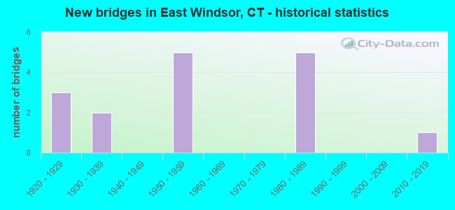
- New bridges - historical statistics
- 31920-1929
- 21930-1939
- 51950-1959
- 51980-1989
- 12010-2019

- Reconstructed bridges - Historical Statistics
- 41980-1989
- 11990-1999
- 12000-2009


- Bridge Condition - Deck
- 22.2%Good
- 55.6%Satisfactory
- 22.2%Fair

- Bridge Condition - Superstructure
- 10.0%Very good
- 20.0%Good
- 30.0%Satisfactory
- 30.0%Fair
- 10.0%Serious

- Bridge Condition - Substructure
- 40.0%Good
- 40.0%Satisfactory
- 20.0%Fair

- Bridge Condition - Channel
- 25.0%Good
- 75.0%Satisfactory
Find on map >> Show street view
Structure Number: 55, Location: 0.3 MI S OF US ROUTE 7 (Lat: 41.105603, Lng: -73.425694), Route carried "on" structure: City street , Year Built: 2015, Status: Open, Structure Length: 5.21m (17.09ft), Average Daily Traffic: 8,000 (year 2017), Truck Traffic: 5%, Average Future Daily Traffic: 11,887 (year 2037), Design Load: HL 93, Features Intersected: INTERSTATE-95, Facility Carried by Structure: FAIRFIELD AVENUE
Minimum Vertical Clearance: 30+ m (98+ ft), Kilometerpoint: 1.384, Lanes on structure: 2, Lanes under structure: 8, Owner: State Highway Agency, Approaching Roadway Width: 12.0m (39.4ft), Material/Design: Steel continuous, Design/Construction: Stringer/Multi-beam, Number Of Spans In Main Unit: 2, Length of Maximum Span: 26.5m (86.9ft), Curb or Sidewalk Widths: Left: 1.7m (5.6ft), Right: 1.7m (5.6ft), Curb-To-Curb Width: 12.0m (39.4ft), Out-to-Out Width: 16.2m (53.1ft)
Condition: Deck: Good, Superstructure: Very good, Substructure: Good, Operating Rating: 37.3 metric tons, Method Used To Determine Operating Rating: Load and Resistance Factor Rating (LRFR) rating reported by rating factor(RF) method using HL-93 loadings, Inventory Rating: 28.5 metric tons, Method Used To Determine Inventory Rating: Load and Resistance Factor Rating (LRFR) rating reported by rating factor(RF) method using HL-93 loadings, Structural Evaluation: Better than present minimum criteria, Deck Geometry: Somewhat better than minimum adequacy, Underclear: Somewhat better than minimum adequacy, Approach Roadway Alignment: Equal to present desirable criteria, Designated Inspection Frequency: Every 24 months, Inspection Date: October 2020, Deck Structure Type: Concrete Cast-file-Place, Wearing Surface/Protective System: Wearing Surface: Bituminous, Membrane: Preformed Fabric, Deck Protection: Epoxy Coated Reinforcing
Find on map >> Show street view
Structure Number: 1524, Location: 1.9 MI SOUTH OF RTE. 140 (Lat: 41.911136, Lng: -72.564186), Route carried "on" structure: State highway 191, Year Built: 1925, Year Reconstructed: 1987, Status: Posted for load, Structure Length: 2.59m (8.50ft), Average Daily Traffic: 1,500 (year 2016), Truck Traffic: 5%, Average Future Daily Traffic: 2,229 (year 2036), Features Intersected: SCANTIC RIVER
Minimum Vertical Clearance: 30+ m (98+ ft), Kilometerpoint: 4.394, Lanes on structure: 2, Owner: State Highway Agency, Approaching Roadway Width: 8.5m (27.9ft), Skew: 4 degrees, Material/Design: Steel, Design/Construction: Truss - Thru, Number Of Spans In Main Unit: 1, Length of Maximum Span: 23.4m (76.8ft), Curb-To-Curb Width: 8.5m (27.9ft), Out-to-Out Width: 8.8m (28.9ft)
Condition: Deck: Satisfactory, Superstructure: Serious, Substructure: Fair, Channel: Satisfactory, Operating Rating: 7.5 metric tons, Method Used To Determine Operating Rating: Load and Resistance Factor Rating (LRFR) rating reported by rating factor(RF) method using HL-93 loadings, Inventory Rating: 5.8 metric tons, Method Used To Determine Inventory Rating: Load and Resistance Factor Rating (LRFR) rating reported by rating factor(RF) method using HL-93 loadings, Structural Evaluation: High priority of replacement, Deck Geometry: Somewhat better than minimum adequacy, Waterway Adequacy: Equal to present desirable criteria, Approach Roadway Alignment: Better than present minimum criteria, Bridge Posting: Required (Relationship of Operating Rating to Maximum Legal Load: > 39.9% below), Designated Inspection Frequency: Every 24 months, Critical Feature Inspection Frequency: Every 24 months, Inspection Date: January 2021, Critical Feature Inspection Date: January 2021, Total Project Cost: $2,135,000 ( Estimate for 2018), Deck Structure Type: Steel plate, Wearing Surface/Protective System: Wearing Surface: Bituminous
Find on map >> Show street view
Structure Number: 1525, Location: 1 MI SOUTH OF ROUTE 140 (Lat: 41.913811, Lng: -72.549747), Route carried "on" structure: State highway 191, Year Built: 1922, Status: Open, Structure Length: 0.82m (2.69ft), Average Daily Traffic: 1,300 (year 2019), Truck Traffic: 3%, Average Future Daily Traffic: 1,932 (year 2039), Features Intersected: BROAD BROOK
Minimum Vertical Clearance: 30+ m (98+ ft), Kilometerpoint: 5.761, Lanes on structure: 2, Owner: State Highway Agency, Approaching Roadway Width: 8.8m (28.9ft), Material/Design: Steel, Design/Construction: Stringer/Multi-beam, Number Of Spans In Main Unit: 1, Length of Maximum Span: 7.0m (23.0ft), Curb or Sidewalk Widths: Left: 0.4m (1.3ft), Right: 0.4m (1.3ft), Curb-To-Curb Width: 9.1m (29.9ft), Out-to-Out Width: 10.0m (32.8ft)
Condition: Deck: Satisfactory, Superstructure: Fair, Substructure: Satisfactory, Channel: Satisfactory, Operating Rating: 61.0 metric tons, Method Used To Determine Operating Rating: Load Factor (LF), Inventory Rating: 36.6 metric tons, Method Used To Determine Inventory Rating: Load Factor (LF), Structural Evaluation: Somewhat better than minimum adequacy, Deck Geometry: Somewhat better than minimum adequacy, Waterway Adequacy: Better than present minimum criteria, Approach Roadway Alignment: Equal to present desirable criteria, Designated Inspection Frequency: Every 24 months, Inspection Date: November 2021, Deck Structure Type: Concrete Cast-file-Place, Wearing Surface/Protective System: Wearing Surface: Bituminous
Find on map >> Show street view
Structure Number: 1526, Location: 0.6 MI SOUTH OF ROUTE 140 (Lat: 41.917247, Lng: -72.545953), Route carried "on" structure: State highway 191, Year Built: 1927, Year Reconstructed: 1985, Status: Open, Structure Length: 1.68m (5.51ft), Average Daily Traffic: 7,100 (year 2016), Truck Traffic: 3%, Average Future Daily Traffic: 10,550 (year 2036), Design Load: H 15, Features Intersected: BROAD BROOK
Minimum Vertical Clearance: 30+ m (98+ ft), Kilometerpoint: 6.373, Lanes on structure: 2, Owner: State Highway Agency, Approaching Roadway Width: 13.4m (44.0ft), Material/Design: Concrete, Design/Construction: Tee Beam, Number Of Spans In Main Unit: 1, Length of Maximum Span: 15.2m (49.9ft), Curb or Sidewalk Widths: Left: 1.5m (4.9ft), Right: 0.0m, Curb-To-Curb Width: 8.5m (27.9ft), Out-to-Out Width: 10.8m (35.4ft)
Condition: Deck: Fair, Superstructure: Fair, Substructure: Satisfactory, Channel: Good, Operating Rating: 42.6 metric tons, Method Used To Determine Operating Rating: Field evaluation and documented engineering judgment, Inventory Rating: 32.7 metric tons, Method Used To Determine Inventory Rating: Field evaluation and documented engineering judgment, Structural Evaluation: Somewhat better than minimum adequacy, Deck Geometry: High priority of replacement, Waterway Adequacy: Equal to present desirable criteria, Approach Roadway Alignment: Equal to present desirable criteria, Designated Inspection Frequency: Every 24 months, Inspection Date: June 2021, Deck Structure Type: Concrete Cast-file-Place, Wearing Surface/Protective System: Wearing Surface: Bituminous, Membrane: Preformed Fabric
Find on map >> Show street view
Structure Number: 4501, Location: JCT WINDSORVILLE ROAD (Lat: 41.890472, Lng: -72.535861), Route carried "on" structure: City street , Year Built: 1936, Year Reconstructed: 2006, Status: Open, Structure Length: 0.82m (2.69ft), Average Daily Traffic: 2,500 (year 2016), Truck Traffic: 3%, Average Future Daily Traffic: 3,715 (year 2036), Design Load: HS 20, Features Intersected: KETCH BROOK, Facility Carried by Structure: WAPPING ROAD
Minimum Vertical Clearance: 30+ m (98+ ft), Kilometerpoint: 0.064, Lanes on structure: 2, Owner: Town or Township Highway Agency, Approaching Roadway Width: 7.3m (24.0ft), Material/Design: Concrete, Design/Construction: Frame, Number Of Spans In Main Unit: 1, Length of Maximum Span: 7.3m (24.0ft), Curb-To-Curb Width: 9.4m (30.8ft), Out-to-Out Width: 10.6m (34.8ft)
Condition: Deck: Satisfactory, Superstructure: Satisfactory, Substructure: Satisfactory, Channel: Satisfactory, Operating Rating: 92.0 metric tons, Method Used To Determine Operating Rating: Load Factor (LF), Inventory Rating: 55.1 metric tons, Method Used To Determine Inventory Rating: Load Factor (LF), Structural Evaluation: Equal to present minimum criteria, Deck Geometry: Meets minimum limits, Waterway Adequacy: Equal to present desirable criteria, Approach Roadway Alignment: Equal to present desirable criteria, Designated Inspection Frequency: Every 24 months, Underwater Inspection Frequency: Every 24 months, Inspection Date: September 2020, Underwater Inspection Date: September 2020, Deck Structure Type: Concrete Cast-file-Place, Wearing Surface/Protective System: Wearing Surface: Bituminous
Find on map >> Show street view
Structure Number: 5281, Location: AT INT PARKSIDE LANE (Lat: 41.812414, Lng: -72.833567), Route carried "on" structure: City street , Year Built: 1981, Status: Open, Structure Length: 1.28m (4.20ft), Average Daily Traffic: 2,033 (year 2018), Truck Traffic: 2%, Average Future Daily Traffic: 3,021 (year 2038), Features Intersected: NOD BROOK, Facility Carried by Structure: ENSIGN DRIVE
Minimum Vertical Clearance: 30+ m (98+ ft), Kilometerpoint: 0.000, Lanes on structure: 2, Owner: Town or Township Highway Agency, Approaching Roadway Width: 9.8m (32.2ft), Skew: 3 degrees, Material/Design: Concrete, Design/Construction: Culvert, Number Of Spans In Main Unit: 2, Length of Maximum Span: 6.1m (20.0ft), Curb or Sidewalk Widths: Left: 0.0m, Right: 2.7m (8.9ft)
Condition: Channel: Good, Culverts: Good, Operating Rating: 42.6 metric tons, Method Used To Determine Operating Rating: Field evaluation and documented engineering judgment, Inventory Rating: 32.7 metric tons, Method Used To Determine Inventory Rating: Field evaluation and documented engineering judgment, Structural Evaluation: Better than present minimum criteria, Waterway Adequacy: Better than present minimum criteria, Approach Roadway Alignment: Equal to present desirable criteria, Designated Inspection Frequency: Every 48 months, Inspection Date: March 2018
Find on map >> Show street view
Structure Number: 55, Location: JCT ELLSWORTH ROAD (Lat: 41.894156, Lng: -72.572778), Route carried "on" structure: City street , Year Built: 1986, Status: Open, Structure Length: 2.56m (8.40ft), Average Daily Traffic: 3,483 (year 2018), Truck Traffic: 10%, Average Future Daily Traffic: 5,175 (year 2038), Design Load: HS 20, Features Intersected: SCANTIC RIVER, Facility Carried by Structure: OMELIA ROAD
Minimum Vertical Clearance: 30+ m (98+ ft), Kilometerpoint: 1.175, Lanes on structure: 2, Owner: Town or Township Highway Agency, Approaching Roadway Width: 9.1m (29.9ft), Material/Design: Prestressed concrete, Design/Construction: Box Beam or Girders - Multiple, Number Of Spans In Main Unit: 1, Length of Maximum Span: 23.2m (76.1ft), Curb or Sidewalk Widths: Left: 0.5m (1.6ft), Right: 2.1m (6.9ft), Curb-To-Curb Width: 9.1m (29.9ft), Out-to-Out Width: 11.7m (38.4ft)
Condition: Deck: Satisfactory, Superstructure: Good, Substructure: Good, Channel: Satisfactory, Operating Rating: 81.1 metric tons, Method Used To Determine Operating Rating: Load Factor (LF), Inventory Rating: 46.5 metric tons, Method Used To Determine Inventory Rating: Load Factor (LF), Structural Evaluation: Better than present minimum criteria, Deck Geometry: Meets minimum limits, Waterway Adequacy: Equal to present desirable criteria, Approach Roadway Alignment: Equal to present desirable criteria, Designated Inspection Frequency: Every 24 months, Inspection Date: July 2020, Deck Structure Type: Other, Wearing Surface/Protective System: Wearing Surface: Bituminous, Membrane: Preformed Fabric
Find on map >> Show street view
Structure Number: 5617, Location: AT EXIT 45 (Lat: 41.930222, Lng: -72.608714), Route carried "on" structure: Interstate 91, Year Built: 1959, Year Reconstructed: 1987, Status: Open, Structure Length: 4.24m (13.91ft), Average Daily Traffic: 108,500 (year 2015), Truck Traffic: 14%, Average Future Daily Traffic: 161,220 (year 2035), Design Load: HS 20+Mod, Features Intersected: ROUTE 140
Minimum Vertical Clearance: 30+ m (98+ ft), Kilometerpoint: 82.205, Lanes on structure: 6, Lanes under structure: 4, Base Highway Network: Yes, Owner: State Highway Agency, Approaching Roadway Width: 33.5m (109.9ft), Skew: 31 degrees, Material/Design: Steel, Design/Construction: Stringer/Multi-beam, Number Of Spans In Main Unit: 3, Length of Maximum Span: 19.8m (65.0ft), Curb-To-Curb Width: 33.5m (109.9ft), Out-to-Out Width: 36.2m (118.8ft)
Condition: Deck: Fair, Superstructure: Fair, Substructure: Fair, Operating Rating: 57.6 metric tons, Method Used To Determine Operating Rating: Load Factor (LF), Inventory Rating: 34.6 metric tons, Method Used To Determine Inventory Rating: Load Factor (LF), Structural Evaluation: Somewhat better than minimum adequacy, Deck Geometry: Superior to present desirable criteria, Underclear: High priority of corrective action, Approach Roadway Alignment: Equal to present desirable criteria, Designated Inspection Frequency: Every 24 months, Inspection Date: December 2020, Deck Structure Type: Concrete Cast-file-Place, Wearing Surface/Protective System: Wearing Surface: Bituminous, Membrane: Built-up
Find on map >> Show street view
Structure Number: 5817, Location: 1.4 MILES SOUTH OF RT 140 (Lat: 41.913653, Lng: -72.556328), Route carried "on" structure: State highway 191, Year Built: 1989, Status: Open, Structure Length: 1.71m (5.61ft), Average Daily Traffic: 2,000 (year 2016), Truck Traffic: 3%, Average Future Daily Traffic: 2,972 (year 2036), Design Load: HS 20, Features Intersected: BROAD BROOK
Minimum Vertical Clearance: 30+ m (98+ ft), Kilometerpoint: 5.150, Lanes on structure: 2, Owner: State Highway Agency, Approaching Roadway Width: 9.1m (29.9ft), Skew: 4 degrees, Material/Design: Concrete, Design/Construction: Culvert, Number Of Spans In Main Unit: 3, Length of Maximum Span: 5.2m (17.1ft)
Condition: Channel: Satisfactory, Culverts: Good, Operating Rating: 41.1 metric tons, Method Used To Determine Operating Rating: Load and Resistance Factor Rating (LRFR) rating reported by rating factor(RF) method using HL-93 loadings, Inventory Rating: 31.8 metric tons, Method Used To Determine Inventory Rating: Load and Resistance Factor Rating (LRFR) rating reported by rating factor(RF) method using HL-93 loadings, Structural Evaluation: Better than present minimum criteria, Waterway Adequacy: Better than present minimum criteria, Approach Roadway Alignment: Equal to present desirable criteria, Designated Inspection Frequency: Every 24 months, Inspection Date: June 2021, Wearing Surface/Protective System: Wearing Surface: Bituminous, Membrane: Built-up
Find on map >> Show street view
Structure Number: 5891, Location: 0.1 MILE WEST OF RTE. 191 (Lat: 41.926289, Lng: -72.546631), Route carried "on" structure: State highway 140, Year Built: 1935, Year Reconstructed: 1990, Status: Open, Structure Length: 1.92m (6.30ft), Average Daily Traffic: 11,300 (year 2015), Truck Traffic: 3%, Average Future Daily Traffic: 16,791 (year 2035), Design Load: HS 20, Features Intersected: SCANTIC RIVER
Minimum Vertical Clearance: 30+ m (98+ ft), Kilometerpoint: 11.684, Lanes on structure: 2, Owner: State Highway Agency, Approaching Roadway Width: 9.8m (32.2ft), Material/Design: Prestressed concrete, Design/Construction: Box Beam or Girders - Multiple, Number Of Spans In Main Unit: 1, Length of Maximum Span: 18.6m (61.0ft), Curb or Sidewalk Widths: Left: 0.4m (1.3ft), Right: 2.1m (6.9ft), Curb-To-Curb Width: 12.2m (40.0ft), Out-to-Out Width: 14.7m (48.2ft)
Condition: Superstructure: Good, Substructure: Good, Channel: Satisfactory, Operating Rating: 33.7 metric tons, Method Used To Determine Operating Rating: Load and Resistance Factor Rating (LRFR) rating reported by rating factor(RF) method using HL-93 loadings, Inventory Rating: 26.9 metric tons, Method Used To Determine Inventory Rating: Load and Resistance Factor Rating (LRFR) rating reported by rating factor(RF) method using HL-93 loadings, Structural Evaluation: Equal to present minimum criteria, Deck Geometry: Somewhat better than minimum adequacy, Waterway Adequacy: Equal to present desirable criteria, Approach Roadway Alignment: Equal to present desirable criteria, Designated Inspection Frequency: Every 24 months, Inspection Date: July 2020, Deck Structure Type: Other, Wearing Surface/Protective System: Wearing Surface: Bituminous, Membrane: Built-up, Deck Protection: Epoxy Coated Reinforcing
Find on map >> Show street view
Structure Number: 5975, Location: EXIT 44 SB ON & OFF RAMPS (Lat: 41.920200, Lng: -72.612958), Route carried "on" structure: Ramp Interstate 91, Year Built: 1989, Status: Open, Structure Length: 7.50m (24.61ft), Average Daily Traffic: 11,000 (year 2015), Truck Traffic: 14%, Average Future Daily Traffic: 16,345 (year 2035), Design Load: HS 20, Features Intersected: INTERSTATE-91
Minimum Vertical Clearance: 30+ m (98+ ft), Kilometerpoint: 0.000, Lanes on structure: 2, Lanes under structure: 7, Owner: State Highway Agency, Approaching Roadway Width: 14.6m (47.9ft), Skew: 32 degrees, Material/Design: Steel continuous, Design/Construction: Stringer/Multi-beam, Number Of Spans In Main Unit: 2, Length of Maximum Span: 39.9m (130.9ft), Curb-To-Curb Width: 14.6m (47.9ft), Out-to-Out Width: 16.7m (54.8ft)
Condition: Deck: Good, Superstructure: Satisfactory, Substructure: Good, Operating Rating: 49.6 metric tons, Method Used To Determine Operating Rating: Load and Resistance Factor Rating (LRFR) rating reported by rating factor(RF) method using HL-93 loadings, Inventory Rating: 38.2 metric tons, Method Used To Determine Inventory Rating: Load and Resistance Factor Rating (LRFR) rating reported by rating factor(RF) method using HL-93 loadings, Structural Evaluation: Equal to present minimum criteria, Deck Geometry: Superior to present desirable criteria, Underclear: Equal to present minimum criteria, Approach Roadway Alignment: Equal to present desirable criteria, Designated Inspection Frequency: Every 24 months, Inspection Date: June 2021, Deck Structure Type: Concrete Cast-file-Place, Wearing Surface/Protective System: Wearing Surface: Bituminous, Membrane: Preformed Fabric, Deck Protection: Epoxy Coated Reinforcing
Find on map >> Show street view
Structure Number: 6007, Location: 0.4 MI N WINDSOR LOCKS TL (Lat: 41.918717, Lng: -72.615525), Route carried "on" structure: Interstate 91, Year Built: 1959, Year Reconstructed: 1989, Status: Open, Structure Length: 4.39m (14.40ft), Average Daily Traffic: 54,800 (year 2015), Truck Traffic: 9%, Average Future Daily Traffic: 81,427 (year 2035), Design Load: HS 20, Features Intersected: SR 510 (MAIN STREET)
Minimum Vertical Clearance: 30+ m (98+ ft), Kilometerpoint: 80.709, Lanes on structure: 4, Lanes under structure: 2, Base Highway Network: Yes, Owner: State Highway Agency, Approaching Roadway Width: 20.1m (65.9ft), Material/Design: Steel continuous, Design/Construction: Stringer/Multi-beam, Number Of Spans In Main Unit: 3, Length of Maximum Span: 19.5m (64.0ft), Curb-To-Curb Width: 20.1m (65.9ft), Out-to-Out Width: 21.5m (70.5ft)
Condition: Deck: Satisfactory, Superstructure: Satisfactory, Substructure: Satisfactory, Operating Rating: 37.6 metric tons, Method Used To Determine Operating Rating: Load and Resistance Factor Rating (LRFR) rating reported by rating factor(RF) method using HL-93 loadings, Inventory Rating: 29.2 metric tons, Method Used To Determine Inventory Rating: Load and Resistance Factor Rating (LRFR) rating reported by rating factor(RF) method using HL-93 loadings, Structural Evaluation: Equal to present minimum criteria, Deck Geometry: Equal to present minimum criteria, Underclear: Equal to present minimum criteria, Approach Roadway Alignment: Equal to present desirable criteria, Designated Inspection Frequency: Every 24 months, Inspection Date: October 2021, Deck Structure Type: Concrete Cast-file-Place, Wearing Surface/Protective System: Wearing Surface: Bituminous, Membrane: Built-up, Deck Protection: Epoxy Coated Reinforcing
Find on map >> Show street view
Structure Number: 5617, Location: AT EXIT 45 (Lat: 41.930222, Lng: -72.608714), Route carried "under" structure: State highway 140, Year Built: 1959, Structure Length: 0. m, Average Daily Traffic: 17,100 (year 2016), Truck Traffic: 6%, Features Intersected: ROUTE 140, Facility Carried by Structure: INTERSTATE-91
Minimum Vertical Clearance: 4.65m (15.26ft), Kilometerpoint: 5.713, Lanes on structure: 6, Lanes under structure: 4, Material/Design: Steel, Design/Construction: Stringer/Multi-beam, Length of Maximum Span: 19.8m (65.0ft)
Find on map >> Show street view
Structure Number: 5975, Location: EXIT 44 SB ON & OFF RAMPS (Lat: 41.920200, Lng: -72.612958), Route carried "under" structure: Interstate 91, Year Built: 1989, Structure Length: 0. m, Average Daily Traffic: 101,100 (year 2015), Truck Traffic: 14%, Features Intersected: INTERSTATE-91
Minimum Vertical Clearance: 6.78m (22.24ft), Kilometerpoint: 80.998, Lanes on structure: 2, Lanes under structure: 7, Material/Design: Steel continuous, Design/Construction: Stringer/Multi-beam, Length of Maximum Span: 39.9m (130.9ft)
Find on map >> Show street view
Structure Number: 6006, Location: 0.4 MI N WINDSOR LOCKS TL (Lat: 41.918883, Lng: -72.615617), Route carried "under" structure: State highway 510, Year Built: 1959, Structure Length: 0. m, Average Daily Traffic: 4,400 (year 2016), Truck Traffic: 3%, Features Intersected: SR 510 (MAIN STREET), Facility Carried by Structure: INTERSTATE-91 SB
Minimum Vertical Clearance: 4.45m (14.60ft), Kilometerpoint: 0.612, Lanes on structure: 4, Lanes under structure: 2, Material/Design: Steel continuous, Design/Construction: Stringer/Multi-beam, Length of Maximum Span: 19.5m (64.0ft)
Find on map >> Show street view
Structure Number: 6007, Location: 0.4 MI N WINDSOR LOCKS TL (Lat: 41.918717, Lng: -72.615525), Route carried "under" structure: State highway 510, Year Built: 1959, Structure Length: 0. m, Average Daily Traffic: 4,400 (year 2016), Truck Traffic: 3%, Features Intersected: SR 510 (MAIN STREET), Facility Carried by Structure: INTERSTATE-91 NB
Minimum Vertical Clearance: 5.69m (18.67ft), Kilometerpoint: 0.595, Lanes on structure: 4, Lanes under structure: 2, Material/Design: Steel continuous, Design/Construction: Stringer/Multi-beam, Length of Maximum Span: 19.5m (64.0ft)