Bridge Statistics for Emeryville, California (CA)
Condition, Traffic, Stress, Structural Evaluation, Project Costs
- National Bridge Inventory (NBI) Statistics
- 15Number of bridges
- 299ft / 91.3mTotal length
- 1,903,680Total average daily traffic
- 140,131Total average daily truck traffic
- National Bridge Inventory (NBI) Registered Bridges for Emeryville
- No street view available for this location
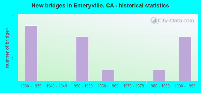
- New bridges - historical statistics
- 51930-1939
- 41950-1959
- 11960-1969
- 11980-1989
- 41990-1999

- Reconstructed bridges - Historical Statistics
- 11980-1989
- 21990-1999


- Bridge Condition - Deck
- 62.5%Good
- 12.5%Satisfactory
- 25.0%Fair

- Bridge Condition - Superstructure
- 75.0%Good
- 12.5%Satisfactory
- 12.5%Fair

- Bridge Condition - Substructure
- 87.5%Good
- 12.5%Fair

- Bridge Condition - Channel
- 50.0%Excellent
- 50.0%Very good
Find on map >> Show street view
Structure Number: 33 0028, Location: 04-ALA-080-3.96-EMV (Lat: 37.840044, Lng: -122.296575), Route carried "on" structure: Interstate 80, Year Built: 1954, Year Reconstructed: 1997, Status: Open, Structure Length: 0.68m (2.23ft), Average Daily Traffic: 531,000 (year 2009), Truck Traffic: 8%, Average Future Daily Traffic: 848,488 (year 2043), Design Load: HS 20, Features Intersected: BURIED WALKWAY
Minimum Vertical Clearance: 30+ m (98+ ft), Kilometerpoint: 3.960, Lanes on structure: 14, Base Highway Network: Yes (, Subroute: 1), Owner: State Highway Agency, Approaching Roadway Width: 51.8m (169.9ft), Skew: 30 degrees, Material/Design: Concrete, Design/Construction: Frame, Number Of Spans In Main Unit: 2, Length of Maximum Span: 3.4m (11.2ft)
Condition: Deck: Good, Superstructure: Good, Substructure: Fair, Operating Rating: 40.8 metric tons, Method Used To Determine Operating Rating: Load Factor (LF), Inventory Rating: 27.2 metric tons, Method Used To Determine Inventory Rating: Load Factor (LF), Structural Evaluation: Somewhat better than minimum adequacy, Approach Roadway Alignment: Equal to present desirable criteria, Designated Inspection Frequency: Every 24 months, Inspection Date: March 2021
Find on map >> Show street view
Structure Number: 33 011, Location: 04-ALA-880-24.74-OAK (Lat: 37.731364, Lng: -122.188894), Route carried "on" structure: City street , Year Built: 1998, Status: Open, Structure Length: 9.30m (30.51ft), Average Daily Traffic: 23,000 (year 2016), Truck Traffic: 1%, Average Future Daily Traffic: 16,762 (year 2038), Design Load: HS 20+Mod, Features Intersected: INTERSTATE 880, Facility Carried by Structure: 98TH AVE
Minimum Vertical Clearance: 30+ m (98+ ft), Kilometerpoint: 0.000, Lanes on structure: 6, Lanes under structure: 8, Owner: State Highway Agency, Approaching Roadway Width: 35.5m (116.5ft), Material/Design: Prestressed concrete continuous, Design/Construction: Box Beam or Girders - Multiple, Number Of Spans In Main Unit: 2, Length of Maximum Span: 47.8m (156.8ft), Curb or Sidewalk Widths: Left: 3.0m (9.8ft), Right: 0.0m, Curb-To-Curb Width: 26.8m (87.9ft), Out-to-Out Width: 35.5m (116.5ft)
Condition: Deck: Fair, Superstructure: Good, Substructure: Good, Operating Rating: 54.1 metric tons, Method Used To Determine Operating Rating: Assigned rating based on Load Factor Design (LFD) reported in metric tons, Inventory Rating: 32.4 metric tons, Method Used To Determine Inventory Rating: Assigned rating based on Load Factor Design (LFD) reported in metric tons, Structural Evaluation: Better than present minimum criteria, Deck Geometry: Better than present minimum criteria, Underclear: Meets minimum limits, Approach Roadway Alignment: Equal to present desirable criteria, Designated Inspection Frequency: Every 24 months, Inspection Date: May 2020, Deck Structure Type: Concrete Cast-file-Place
Find on map >> Show street view
Structure Number: 33 0117, Location: 04-ALA-123-0.22-EMV (Lat: 37.828453, Lng: -122.278892), Route carried "on" structure: State highway 123, Year Built: 1936, Status: Open, Structure Length: 1.58m (5.18ft), Average Daily Traffic: 24,350 (year 2009), Truck Traffic: 1%, Average Future Daily Traffic: 43,911 (year 2037), Design Load: HS 15, Features Intersected: SR 123 (MACARTHUR BLVD)
Minimum Vertical Clearance: 30+ m (98+ ft), Kilometerpoint: 0.220, Lanes on structure: 9, Lanes under structure: 3, Base Highway Network: Yes (Inventory Route: 1, Subroute: 1), Owner: State Highway Agency, Approaching Roadway Width: 43.3m (142.1ft), Material/Design: Concrete, Design/Construction: Slab, Number Of Spans In Main Unit: 1, Length of Maximum Span: 14.0m (45.9ft), Curb or Sidewalk Widths: Left: 1.0m (3.3ft), Right: 1.0m (3.3ft), Curb-To-Curb Width: 43.3m (142.1ft), Out-to-Out Width: 60.5m (198.5ft)
Condition: Deck: Good, Superstructure: Good, Substructure: Good, Operating Rating: 96.9 metric tons, Method Used To Determine Operating Rating: Load Factor (LF), Inventory Rating: 58.3 metric tons, Method Used To Determine Inventory Rating: Load Factor (LF), Structural Evaluation: Better than present minimum criteria, Deck Geometry: Superior to present desirable criteria, Underclear: High priority of corrective action, Approach Roadway Alignment: Equal to present desirable criteria, Designated Inspection Frequency: Every 48 months, Inspection Date: October 2018, Deck Structure Type: Concrete Cast-file-Place, Wearing Surface/Protective System: Wearing Surface: Bituminous
Find on map >> Show street view
Structure Number: 33 0272, Location: 04-ALA-880-7.32-FMT (Lat: 37.530911, Lng: -122.003972), Route carried "on" structure: Interstate 880, Year Built: 1958, Year Reconstructed: 1993, Status: Open, Structure Length: 3.32m (10.89ft), Average Daily Traffic: 187,000 (year 2017), Truck Traffic: 7%, Average Future Daily Traffic: 252,200 (year 2039), Design Load: HS 20, Features Intersected: HETCH HETCHY AQUEDUCT
Minimum Vertical Clearance: 30+ m (98+ ft), Kilometerpoint: 7.320, Lanes on structure: 8, Base Highway Network: Yes (Inventory Route: 8, Subroute: 1), Owner: State Highway Agency, Approaching Roadway Width: 33.5m (109.9ft), Skew: 34 degrees, Material/Design: Concrete continuous, Design/Construction: Slab, Number Of Spans In Main Unit: 5, Length of Maximum Span: 6.4m (21.0ft), Curb-To-Curb Width: 42.2m (138.5ft), Out-to-Out Width: 42.9m (140.7ft)
Condition: Deck: Fair, Superstructure: Fair, Substructure: Good, Channel: Very good, Operating Rating: 36.6 metric tons, Method Used To Determine Operating Rating: Load Factor (LF), Inventory Rating: 22.0 metric tons, Method Used To Determine Inventory Rating: Load Factor (LF), Structural Evaluation: Somewhat better than minimum adequacy, Deck Geometry: Superior to present desirable criteria, Waterway Adequacy: Superior to present desirable criteria, Approach Roadway Alignment: Equal to present desirable criteria, Designated Inspection Frequency: Every 24 months, Inspection Date: April 2021, Deck Structure Type: Concrete Cast-file-Place
Find on map >> Show street view
Structure Number: 33 0278, Location: 04-ALA-080-3.49-EMV (Lat: 37.834008, Lng: -122.294119), Route carried "on" structure: Interstate 80, Year Built: 1936, Year Reconstructed: 1997, Status: Open, Structure Length: 3.42m (11.22ft), Average Daily Traffic: 531,000 (year 2009), Truck Traffic: 8%, Average Future Daily Traffic: 847,421 (year 2043), Features Intersected: TEMESCAL CREEK
Minimum Vertical Clearance: 30+ m (98+ ft), Kilometerpoint: 3.490, Lanes on structure: 14, Base Highway Network: Yes (, Subroute: 1), Owner: State Highway Agency, Approaching Roadway Width: 82.0m (269.0ft), Skew: 20 degrees, Material/Design: Concrete continuous, Design/Construction: Culvert, Number Of Spans In Main Unit: 4, Number Of Approach Spans: 2, Length of Maximum Span: 21.4m (70.2ft), Curb-To-Curb Width: 61.0m (200.1ft), Out-to-Out Width: 62.0m (203.4ft)
Condition: Channel: Excellent, Culverts: Good, Operating Rating: 40.5 metric tons, Method Used To Determine Operating Rating: Field evaluation and documented engineering judgment, Inventory Rating: 24.3 metric tons, Method Used To Determine Inventory Rating: Field evaluation and documented engineering judgment, Structural Evaluation: Equal to present minimum criteria, Deck Geometry: Superior to present desirable criteria, Waterway Adequacy: Superior to present desirable criteria, Approach Roadway Alignment: Equal to present desirable criteria, Designated Inspection Frequency: Every 24 months, Inspection Date: March 2021
Find on map >> Show street view
Structure Number: 33 048, Location: 04-ALA-980-0.60-OAK (Lat: 37.805642, Lng: -122.279183), Route carried "on" structure: City street , Year Built: 1981, Status: Open, Structure Length: 9.57m (31.40ft), Average Daily Traffic: 8,000 (year 2012), Truck Traffic: 2%, Average Future Daily Traffic: 8,459 (year 2037), Design Load: HS 20+Mod, Features Intersected: INTERSTATE 980, Facility Carried by Structure: 12 TH STREET
Minimum Vertical Clearance: 30+ m (98+ ft), Kilometerpoint: 0.000, Lanes on structure: 3, Lanes under structure: 7, Base Highway Network: Yes (Inventory Route: 9, Subroute: 1), Owner: State Highway Agency, Approaching Roadway Width: 16.5m (54.1ft), Skew: 9 degrees, Material/Design: Prestressed concrete continuous, Design/Construction: Box Beam or Girders - Multiple, Number Of Spans In Main Unit: 3, Length of Maximum Span: 37.8m (124.0ft), Curb or Sidewalk Widths: Left: 3.0m (9.8ft), Right: 0.0m, Curb-To-Curb Width: 16.5m (54.1ft), Out-to-Out Width: 20.8m (68.2ft)
Condition: Deck: Good, Superstructure: Satisfactory, Substructure: Good, Operating Rating: 54.1 metric tons, Method Used To Determine Operating Rating: Assigned rating based on Load Factor Design (LFD) reported in metric tons, Inventory Rating: 32.4 metric tons, Method Used To Determine Inventory Rating: Assigned rating based on Load Factor Design (LFD) reported in metric tons, Structural Evaluation: Equal to present minimum criteria, Deck Geometry: Equal to present minimum criteria, Underclear: Equal to present minimum criteria, Approach Roadway Alignment: Equal to present desirable criteria, Designated Inspection Frequency: Every 24 months, Inspection Date: May 2020, Deck Structure Type: Concrete Cast-file-Place
Find on map >> Show street view
Structure Number: 33 0487, Location: 04-ALA-123-0.15-EMV (Lat: 37.828339, Lng: -122.280161), Route carried "on" structure: City street , Year Built: 1936, Status: Open, Structure Length: 1.58m (5.18ft), Average Daily Traffic: 3,000 (year 1998), Truck Traffic: 2%, Average Future Daily Traffic: 5,327 (year 2037), Design Load: HS 15, Features Intersected: STATE ROUTE 123, Facility Carried by Structure: PERALTA STREET
Minimum Vertical Clearance: 30+ m (98+ ft), Kilometerpoint: 0.000, Lanes on structure: 3, Lanes under structure: 3, Owner: State Highway Agency, Approaching Roadway Width: 15.8m (51.8ft), Material/Design: Concrete, Design/Construction: Slab, Number Of Spans In Main Unit: 1, Length of Maximum Span: 14.0m (45.9ft), Curb or Sidewalk Widths: Left: 4.1m (13.5ft), Right: 4.1m (13.5ft), Curb-To-Curb Width: 15.8m (51.8ft), Out-to-Out Width: 24.8m (81.4ft)
Condition: Deck: Good, Superstructure: Good, Substructure: Good, Operating Rating: 99.8 metric tons, Method Used To Determine Operating Rating: Load Factor (LF), Inventory Rating: 63.5 metric tons, Method Used To Determine Inventory Rating: Load Factor (LF), Structural Evaluation: Better than present minimum criteria, Deck Geometry: Better than present minimum criteria, Underclear: High priority of corrective action, Approach Roadway Alignment: Equal to present desirable criteria, Designated Inspection Frequency: Every 48 months, Inspection Date: October 2018, Deck Structure Type: Concrete Cast-file-Place, Wearing Surface/Protective System: Wearing Surface: Bituminous
Find on map >> Show street view
Structure Number: 33C0183, Location: 0.3 MI E OF I-80 (Lat: 37.838836, Lng: -122.292172), Route carried "on" structure: City street , Year Built: 1968, Status: Open, Structure Length: 34.50m (113.19ft), Average Daily Traffic: 20,000 (year 1976), Truck Traffic: 5%, Average Future Daily Traffic: 32,604 (year 2040), Features Intersected: UP RR, BNSF RY, & AMTRAK, Facility Carried by Structure: POWELL ST
Minimum Vertical Clearance: 4.24m (13.91ft), Kilometerpoint: 0.000, Lanes on structure: 4, Lanes under structure: 8, Owner: City or Municipal Highway Agency, Approaching Roadway Width: 20.1m (65.9ft), Material/Design: Prestressed concrete, Design/Construction: Stringer/Multi-beam, Number Of Spans In Main Unit: 15, Number Of Approach Spans: 5, Length of Maximum Span: 32.9m (107.9ft), Curb or Sidewalk Widths: Left: 0.6m (2.0ft), Right: 0.6m (2.0ft), Curb-To-Curb Width: 15.8m (51.8ft), Out-to-Out Width: 17.5m (57.4ft)
Condition: Deck: Satisfactory, Superstructure: Good, Substructure: Good, Operating Rating: 54.4 metric tons, Method Used To Determine Operating Rating: Load Factor (LF), Inventory Rating: 32.7 metric tons, Method Used To Determine Inventory Rating: Load Factor (LF), Structural Evaluation: Better than present minimum criteria, Deck Geometry: Meets minimum limits, Underclear: Meets minimum limits, Approach Roadway Alignment: Equal to present minimum criteria, Designated Inspection Frequency: Every 24 months, Inspection Date: November 2020, Deck Structure Type: Concrete Cast-file-Place
Find on map >> Show street view
Structure Number: 33C0399, Location: 500 FT W OF HORTON ST (Lat: 37.828844, Lng: -122.292558), Route carried "on" structure: City street , Year Built: 1995, Status: Open, Structure Length: 27.30m (89.57ft), Average Daily Traffic: 8,630 (year 1997), Truck Traffic: 2%, Average Future Daily Traffic: 10,940 (year 2042), Features Intersected: UP RR SPUR, Facility Carried by Structure: 40TH STREET
Minimum Vertical Clearance: 30+ m (98+ ft), Kilometerpoint: 0.000, Lanes on structure: 4, Lanes under structure: 2, Owner: City or Municipal Highway Agency, Approaching Roadway Width: 22.0m (72.2ft), Skew: 9 degrees, Material/Design: Prestressed concrete continuous, Design/Construction: Box Beam or Girders - Multiple, Number Of Spans In Main Unit: 8, Length of Maximum Span: 39.6m (129.9ft), Curb or Sidewalk Widths: Left: 1.8m (5.9ft), Right: 0.0m, Curb-To-Curb Width: 19.5m (64.0ft), Out-to-Out Width: 22.3m (73.2ft)
Condition: Deck: Good, Superstructure: Good, Substructure: Good, Operating Rating: 54.1 metric tons, Method Used To Determine Operating Rating: Field evaluation and documented engineering judgment, Inventory Rating: 32.4 metric tons, Method Used To Determine Inventory Rating: Field evaluation and documented engineering judgment, Structural Evaluation: Better than present minimum criteria, Deck Geometry: Better than present minimum criteria, Underclear: Somewhat better than minimum adequacy, Approach Roadway Alignment: Equal to present desirable criteria, Designated Inspection Frequency: Every 24 months, Inspection Date: November 2020, Deck Structure Type: Concrete Cast-file-Place
Find on map >> Show street view
Structure Number: 33 002, Location: 04-ALA-080-3.79-EMV (Lat: 37.837681, Lng: -122.296181), Route carried "under" structure: City street , Year Built: 1954, Structure Length: 0. m, Average Daily Traffic: 30,000 (year 2009), Truck Traffic: 10%, Features Intersected: POWELL STREET, Facility Carried by Structure: INTERSTATE 80
Minimum Vertical Clearance: 4.60m (15.09ft), Kilometerpoint: 0.000, Lanes on structure: 13, Lanes under structure: 7, Material/Design: Concrete continuous, Design/Construction: Box Beam or Girders - Multiple, Length of Maximum Span: 19.8m (65.0ft)
Find on map >> Show street view
Structure Number: 33 0117, Location: 04-ALA-123-0.22-EMV (Lat: 37.828453, Lng: -122.278892), Route carried "under" structure: State highway 123, Year Built: 1936, Structure Length: 0. m, Average Daily Traffic: 24,350 (year 2009), Truck Traffic: 1%, Features Intersected: SR 123 (MACARTHUR BLVD)
Minimum Vertical Clearance: 4.39m (14.40ft), Kilometerpoint: 0.220, Lanes on structure: 9, Lanes under structure: 3, Material/Design: Concrete, Design/Construction: Slab, Length of Maximum Span: 14.0m (45.9ft)
Find on map >> Show street view
Structure Number: 33 0190F, Location: 04-ALA-080-4.45-EMV (Lat: 37.847092, Lng: -122.298708), Route carried "under" structure: Interstate 80, Year Built: 1954, Structure Length: 0. m, Average Daily Traffic: 239,000 (year 2009), Truck Traffic: 7%, Features Intersected: INTERSTATE 80
Minimum Vertical Clearance: 4.59m (15.06ft), Kilometerpoint: 4.450, Lanes on structure: 2, Lanes under structure: 10, Material/Design: Concrete continuous, Design/Construction: Box Beam or Girders - Multiple, Length of Maximum Span: 20.8m (68.2ft)
Find on map >> Show street view
Structure Number: 33 0487, Location: 04-ALA-123-0.15-EMV (Lat: 37.828339, Lng: -122.280161), Route carried "under" structure: State highway 123, Year Built: 1936, Structure Length: 0. m, Average Daily Traffic: 24,350 (year 2009), Truck Traffic: 1%, Features Intersected: STATE ROUTE 123, Facility Carried by Structure: PERALTA STREET
Minimum Vertical Clearance: 4.39m (14.40ft), Kilometerpoint: 0.150, Lanes on structure: 3, Lanes under structure: 3, Material/Design: Concrete, Design/Construction: Slab, Length of Maximum Span: 14.0m (45.9ft)
Find on map >> Show street view
Structure Number: 33 0601, Location: 04-ALA-080-3.14-EMV (Lat: 37.827883, Lng: -122.295711), Route carried "under" structure: Interstate 580, Year Built: 1998, Structure Length: 0. m, Average Daily Traffic: 125,000 (year 2011), Truck Traffic: 8%, Features Intersected: INTERSTATE 80 WB, Facility Carried by Structure: W80 HOV-TOLL PLAZA
Minimum Vertical Clearance: 5.94m (19.49ft), Kilometerpoint: 47.250, Lanes on structure: 1, Lanes under structure: 6, Material/Design: Prestressed concrete continuous, Design/Construction: Box Beam or Girders - Multiple, Length of Maximum Span: 62.5m (205.1ft)
Find on map >> Show street view
Structure Number: 33 0601, Location: 04-ALA-080-3.14-EMV (Lat: 37.827883, Lng: -122.295711), Route carried "under" structure: Interstate 80, Year Built: 1998, Structure Length: 0. m, Average Daily Traffic: 125,000 (year 2011), Truck Traffic: 8%, Features Intersected: INTERSTATE 80 WB
Minimum Vertical Clearance: 5.99m (19.65ft), Kilometerpoint: 3.700, Lanes on structure: 1, Lanes under structure: 6, Material/Design: Prestressed concrete continuous, Design/Construction: Box Beam or Girders - Multiple, Length of Maximum Span: 62.5m (205.1ft)