Bridge Statistics for Fife, Washington (WA)
Condition, Traffic, Stress, Structural Evaluation, Project Costs
- National Bridge Inventory (NBI) Statistics
- 10Number of bridges
- 151ft / 45.6mTotal length
- $40,738,000Total costs
- 668,019Total average daily traffic
- 56,801Total average daily truck traffic
- National Bridge Inventory (NBI) Registered Bridges for Fife
- No street view available for this location
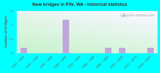
- New bridges - historical statistics
- 11930-1939
- 61960-1969
- 11990-1999
- 12000-2009
- 12020-2022


- Bridge Condition - Deck
- 14.3%Very good
- 57.1%Good
- 14.3%Satisfactory
- 14.3%Fair

- Bridge Condition - Superstructure
- 28.6%Very good
- 42.9%Good
- 28.6%Fair

- Bridge Condition - Substructure
- 28.6%Very good
- 42.9%Good
- 14.3%Satisfactory
- 14.3%Fair
Find on map >> Show street view
Structure Number: 6379A, Location: 1.4 N JCT SR 167 (Lat: 47.240361, Lng: -122.374333), Route carried "on" structure: Interstate 5, Year Built: 1960, Year Reconstructed: 2010, Status: Open, Structure Length: 1.83m (6.00ft), Average Daily Traffic: 98,825 (year 2019), Truck Traffic: 8%, Average Future Daily Traffic: 143,098 (year 2039), Design Load: HS 20+Mod, Features Intersected: WAPATO CREEK
Minimum Vertical Clearance: 30+ m (98+ ft), Kilometerpoint: 219.885, Lanes on structure: 5, Base Highway Network: Yes, Owner: State Highway Agency, Approaching Roadway Width: 24.1m (79.1ft), Skew: 1 degrees, Material/Design: Concrete continuous, Design/Construction: Slab, Number Of Spans In Main Unit: 3, Length of Maximum Span: 6.7m (22.0ft), Curb-To-Curb Width: 24.2m (79.4ft), Out-to-Out Width: 25.5m (83.7ft)
Condition: Deck: Good, Superstructure: Good, Substructure: Good, Channel: Very good, Operating Rating: 58.0 metric tons, Method Used To Determine Operating Rating: Load Factor (LF), Inventory Rating: 35.4 metric tons, Method Used To Determine Inventory Rating: Load Factor (LF), Structural Evaluation: Better than present minimum criteria, Deck Geometry: Equal to present minimum criteria, Waterway Adequacy: Equal to present desirable criteria, Approach Roadway Alignment: Equal to present desirable criteria, Length Of Structure Improvement: 1.83m (6.00ft), Designated Inspection Frequency: Every 48 months, Inspection Date: December 2020, Bridge Improvement Cost: $972,000, Roadway Improvement Cost: $194,000, Total Project Cost: $1,944,000 ( Estimate for 2014), Deck Structure Type: Concrete Cast-file-Place, Wearing Surface/Protective System: Wearing Surface: Bituminous, Membrane: Preformed Fabric
Find on map >> Show street view
Structure Number: 6379B, Location: 1.4 N JCT SR 167 (Lat: 47.240778, Lng: -122.374500), Route carried "on" structure: Interstate 5, Year Built: 1960, Year Reconstructed: 2010, Status: Open, Structure Length: 1.83m (6.00ft), Average Daily Traffic: 98,825 (year 2019), Truck Traffic: 8%, Average Future Daily Traffic: 143,098 (year 2039), Design Load: HS 20+Mod, Features Intersected: WAPATO CREEK
Minimum Vertical Clearance: 30+ m (98+ ft), Kilometerpoint: 219.885, Lanes on structure: 4, Base Highway Network: Yes, Owner: State Highway Agency, Approaching Roadway Width: 26.2m (86.0ft), Skew: 1 degrees, Material/Design: Concrete continuous, Design/Construction: Slab, Number Of Spans In Main Unit: 3, Length of Maximum Span: 6.7m (22.0ft), Curb-To-Curb Width: 24.6m (80.7ft), Out-to-Out Width: 26.2m (86.0ft)
Condition: Deck: Good, Superstructure: Good, Substructure: Good, Channel: Very good, Operating Rating: 58.0 metric tons, Method Used To Determine Operating Rating: Load Factor (LF), Inventory Rating: 35.4 metric tons, Method Used To Determine Inventory Rating: Load Factor (LF), Structural Evaluation: Better than present minimum criteria, Deck Geometry: Superior to present desirable criteria, Waterway Adequacy: Equal to present desirable criteria, Approach Roadway Alignment: Equal to present desirable criteria, Length Of Structure Improvement: 1.83m (6.00ft), Designated Inspection Frequency: Every 48 months, Inspection Date: December 2020, Bridge Improvement Cost: $1,056,000, Roadway Improvement Cost: $211,000, Total Project Cost: $2,112,000 ( Estimate for 2014), Deck Structure Type: Concrete Cast-file-Place, Wearing Surface/Protective System: Wearing Surface: Bituminous, Membrane: Preformed Fabric
Find on map >> Show street view
Structure Number: 6480A, Location: 0.8 N JCT SR 167 (Lat: 47.241722, Lng: -122.385750), Route carried "on" structure: City street , Year Built: 1961, Status: Open, Structure Length: 9.14m (29.99ft), Average Daily Traffic: 16,530 (year 2008), Truck Traffic: 5%, Average Future Daily Traffic: 29,027 (year 2036), Design Load: HS 20, Features Intersected: I-5, Facility Carried by Structure: PORT OF TACOMA RD
Minimum Vertical Clearance: 30+ m (98+ ft), Kilometerpoint: 0.177, Lanes on structure: 3, Lanes under structure: 8, Base Highway Network: Yes, Owner: State Highway Agency, Approaching Roadway Width: 17.7m (58.1ft), Material/Design: Prestressed concrete, Design/Construction: Stringer/Multi-beam, Number Of Spans In Main Unit: 4, Length of Maximum Span: 31.1m (102.0ft), Curb or Sidewalk Widths: Left: 0.5m (1.6ft), Right: 0.5m (1.6ft), Curb-To-Curb Width: 14.2m (46.6ft), Out-to-Out Width: 15.7m (51.5ft)
Condition: Deck: Good, Superstructure: Good, Substructure: Satisfactory, Operating Rating: 61.7 metric tons, Method Used To Determine Operating Rating: Load Factor (LF), Inventory Rating: 32.7 metric tons, Method Used To Determine Inventory Rating: Load Factor (LF), Structural Evaluation: Equal to present minimum criteria, Deck Geometry: Somewhat better than minimum adequacy, Underclear: Equal to present minimum criteria, Approach Roadway Alignment: Equal to present desirable criteria, Length Of Structure Improvement: 9.14m (29.99ft), Designated Inspection Frequency: Every 24 months, Inspection Date: December 2020, Bridge Improvement Cost: $3,600,000, Roadway Improvement Cost: $720,000, Total Project Cost: $7,200,000 ( Estimate for 2014), Deck Structure Type: Concrete Cast-file-Place, Wearing Surface/Protective System: Wearing Surface: Latex Concrete
Find on map >> Show street view
Structure Number: 6480B, Location: JCT I-5 (Lat: 47.240417, Lng: -122.357056), Route carried "on" structure: State highway 99, Year Built: 1961, Status: Open, Structure Length: 9.78m (32.09ft), Average Daily Traffic: 29,571 (year 2019), Truck Traffic: 9%, Average Future Daily Traffic: 42,818 (year 2039), Design Load: HS 20, Features Intersected: I-5, RAMPS
Minimum Vertical Clearance: 30+ m (98+ ft), Kilometerpoint: 0.001, Lanes on structure: 4, Lanes under structure: 12, Base Highway Network: Yes, Owner: State Highway Agency, Approaching Roadway Width: 16.5m (54.1ft), Material/Design: Prestressed concrete, Design/Construction: Stringer/Multi-beam, Number Of Spans In Main Unit: 4, Length of Maximum Span: 25.9m (85.0ft), Curb or Sidewalk Widths: Left: 1.0m (3.3ft), Right: 1.0m (3.3ft), Curb-To-Curb Width: 16.5m (54.1ft), Out-to-Out Width: 19.4m (63.6ft)
Condition: Deck: Good, Superstructure: Fair, Substructure: Good, Operating Rating: 60.8 metric tons, Method Used To Determine Operating Rating: Load Factor (LF), Inventory Rating: 33.6 metric tons, Method Used To Determine Inventory Rating: Load Factor (LF), Structural Evaluation: Somewhat better than minimum adequacy, Deck Geometry: Meets minimum limits, Underclear: High priority of corrective action, Approach Roadway Alignment: Equal to present desirable criteria, Length Of Structure Improvement: 9.78m (32.09ft), Designated Inspection Frequency: Every 24 months, Inspection Date: November 2021, Bridge Improvement Cost: $3,595,000, Roadway Improvement Cost: $719,000, Total Project Cost: $7,190,000 ( Estimate for 2014), Deck Structure Type: Concrete Cast-file-Place, Wearing Surface/Protective System: Wearing Surface: Latex Concrete
Find on map >> Show street view
Structure Number: 19333A, Location: 0.9 N JCT SR 99 (Lat: 47.242228, Lng: -122.338547), Route carried "on" structure: County highway , Year Built: 2021, Status: Open, Structure Length: 6.89m (22.60ft), Average Daily Traffic: 17,977 (year 2020), Truck Traffic: 30%, Average Future Daily Traffic: 28,888 (year 2040), Design Load: HL 93, Features Intersected: I-5, Facility Carried by Structure: 70TH AVE E
Minimum Vertical Clearance: 30+ m (98+ ft), Kilometerpoint: 0.241, Lanes on structure: 4, Lanes under structure: 10, Owner: State Highway Agency, Approaching Roadway Width: 16.2m (53.1ft), Skew: 12 degrees, Material/Design: Prestressed concrete, Design/Construction: Stringer/Multi-beam, Number Of Spans In Main Unit: 1, Length of Maximum Span: 67.1m (220.1ft), Curb or Sidewalk Widths: Left: 0.0m, Right: 3.7m (12.1ft), Curb-To-Curb Width: 16.2m (53.1ft), Out-to-Out Width: 20.7m (67.9ft)
Condition: Deck: Very good, Superstructure: Very good, Substructure: Very good, Operating Rating: 67.4 metric tons, Method Used To Determine Operating Rating: Load and Resistance Factor Rating (LRFR) rating reported by rating factor(RF) method using HL-93 loadings, Inventory Rating: 43.1 metric tons, Method Used To Determine Inventory Rating: Load and Resistance Factor Rating (LRFR) rating reported by rating factor(RF) method using HL-93 loadings, Structural Evaluation: Equal to present desirable criteria, Deck Geometry: Meets minimum limits, Underclear: Superior to present desirable criteria, Approach Roadway Alignment: Equal to present desirable criteria, Length Of Structure Improvement: 6.89m (22.60ft), Designated Inspection Frequency: Every 24 months, Inspection Date: July 2021, Bridge Improvement Cost: $2,486,000, Roadway Improvement Cost: $497,000, Total Project Cost: $4,972,000 ( Estimate for 2014), Deck Structure Type: Concrete Cast-file-Place, Wearing Surface/Protective System: Wearing Surface: Monolithic Concrete, Deck Protection: Epoxy Coated Reinforcing
Find on map >> Show street view
Structure Number: 82355, Location: 0.1 N JCT SR 410 (Lat: 47.213689, Lng: -122.341925), Route carried "on" structure: County highway 96590, Year Built: 1931, Status: Open, Structure Length: 10.52m (34.51ft), Average Daily Traffic: 7,250 (year 2021), Truck Traffic: 5%, Average Future Daily Traffic: 12,000 (year 2042), Design Load: H 20, Features Intersected: PUYALLUP RIVER, Facility Carried by Structure: 66 AV E
Minimum Vertical Clearance: 30+ m (98+ ft), Kilometerpoint: 0.001, Lanes on structure: 2, Owner: County Highway Agency, Approaching Roadway Width: 7.9m (25.9ft), Material/Design: Steel, Design/Construction: Truss - Thru, Number Of Spans In Main Unit: 1, Number Of Approach Spans: 2, Length of Maximum Span: 93.9m (308.1ft), Curb or Sidewalk Widths: Left: 0.0m, Right: 2.1m (6.9ft), Curb-To-Curb Width: 6.1m (20.0ft), Out-to-Out Width: 8.8m (28.9ft)
Condition: Deck: Fair, Superstructure: Fair, Substructure: Fair, Channel: Very good, Operating Rating: 47.2 metric tons, Method Used To Determine Operating Rating: Load Factor (LF), Inventory Rating: 28.1 metric tons, Method Used To Determine Inventory Rating: Load Factor (LF), Structural Evaluation: Somewhat better than minimum adequacy, Deck Geometry: High priority of replacement, Waterway Adequacy: Equal to present desirable criteria, Approach Roadway Alignment: High priority of corrective action, Length Of Structure Improvement: 10.82m (35.50ft), Designated Inspection Frequency: Every 24 months, Critical Feature Inspection Frequency: Every 24 months, Inspection Date: May 2021, Critical Feature Inspection Date: May 2021, Bridge Improvement Cost: $5,396,000, Roadway Improvement Cost: $1,079,000, Total Project Cost: $10,792,000 ( Estimate for 2020), Deck Structure Type: Concrete Cast-file-Place, Wearing Surface/Protective System: Wearing Surface: Monolithic Concrete
Find on map >> Show street view
Structure Number: 86638, Location: 0.3 S JCT 20 ST E (Lat: 47.232461, Lng: -122.367361), Route carried "on" structure: City street 68911, Year Built: 1993, Status: Open, Structure Length: 4.88m (16.01ft), Average Daily Traffic: 5,500 (year 2021), Truck Traffic: 10%, Average Future Daily Traffic: 8,800 (year 2042), Design Load: HS 20, Features Intersected: UNION PACIFIC RAILROAD, Facility Carried by Structure: FRANK ALBERT RD E
Minimum Vertical Clearance: 30+ m (98+ ft), Kilometerpoint: 0.001, Lanes on structure: 2, Owner: City or Municipal Highway Agency, Approaching Roadway Width: 7.3m (24.0ft), Skew: 2 degrees, Material/Design: Concrete continuous, Design/Construction: Stringer/Multi-beam, Number Of Spans In Main Unit: 1, Number Of Approach Spans: 2, Length of Maximum Span: 22.3m (73.2ft), Curb or Sidewalk Widths: Left: 0.0m, Right: 1.7m (5.6ft), Curb-To-Curb Width: 7.9m (25.9ft), Out-to-Out Width: 13.6m (44.6ft)
Condition: Deck: Satisfactory, Superstructure: Very good, Substructure: Very good, Operating Rating: 49.9 metric tons, Method Used To Determine Operating Rating: Load and Resistance Factor Rating (LRFR) rating reported by rating factor(RF) method using HL-93 loadings, Inventory Rating: 40.5 metric tons, Method Used To Determine Inventory Rating: Load and Resistance Factor Rating (LRFR) rating reported by rating factor(RF) method using HL-93 loadings, Structural Evaluation: Equal to present desirable criteria, Deck Geometry: High priority of replacement, Underclear: Superior to present desirable criteria, Approach Roadway Alignment: Equal to present desirable criteria, Length Of Structure Improvement: 5.18m (16.99ft), Designated Inspection Frequency: Every 24 months, Inspection Date: October 2021, Bridge Improvement Cost: $2,584,000, Roadway Improvement Cost: $517,000, Total Project Cost: $5,168,000 ( Estimate for 2014), Deck Structure Type: Concrete Cast-file-Place, Wearing Surface/Protective System: Wearing Surface: Monolithic Concrete, Deck Protection: Epoxy Coated Reinforcing
Find on map >> Show street view
Structure Number: 88553, Location: 0.1 S VALLEY AVE (Lat: 47.226372, Lng: -122.336422), Route carried "on" structure: County highway 96710, Year Built: 2009, Status: Open, Structure Length: 0.73m (2.40ft), Average Daily Traffic: 9,500 (year 2021), Truck Traffic: 5%, Average Future Daily Traffic: 15,200 (year 2042), Design Load: HL 93, Features Intersected: WAPATO CREEK, Facility Carried by Structure: 70 AV E
Minimum Vertical Clearance: 30+ m (98+ ft), Kilometerpoint: 1.609, Lanes on structure: 3, Base Highway Network: Yes, Owner: City or Municipal Highway Agency, Approaching Roadway Width: 11.0m (36.1ft), Skew: 3 degrees, Material/Design: Concrete, Design/Construction: Culvert, Number Of Spans In Main Unit: 1, Length of Maximum Span: 7.3m (24.0ft)
Condition: Channel: Very good, Culverts: Very good, Operating Rating: 51.5 metric tons, Method Used To Determine Operating Rating: Load and Resistance Factor Rating (LRFR) rating reported by rating factor(RF) method using HL-93 loadings, Inventory Rating: 39.5 metric tons, Method Used To Determine Inventory Rating: Load and Resistance Factor Rating (LRFR) rating reported by rating factor(RF) method using HL-93 loadings, Structural Evaluation: Equal to present desirable criteria, Waterway Adequacy: Equal to present desirable criteria, Approach Roadway Alignment: Equal to present desirable criteria, Length Of Structure Improvement: 1.04m (3.41ft), Designated Inspection Frequency: Every 24 months, Inspection Date: October 2021, Bridge Improvement Cost: $680,000, Roadway Improvement Cost: $136,000, Total Project Cost: $1,360,000 ( Estimate for 2020)
Find on map >> Show street view
Structure Number: 6480A, Location: 0.8 N JCT SR 167 (Lat: 47.241722, Lng: -122.385750), Route carried "under" structure: Interstate 5, Year Built: 1961, Structure Length: 0. m, Average Daily Traffic: 209,999 (year 2019), Truck Traffic: 8%, Features Intersected: I-5, Facility Carried by Structure: PORT OF TACOMA RD
Minimum Vertical Clearance: 6.12m (20.08ft), Kilometerpoint: 219.016, Lanes on structure: 3, Lanes under structure: 8, Material/Design: Prestressed concrete, Design/Construction: Stringer/Multi-beam, Length of Maximum Span: 31.1m (102.0ft)
Find on map >> Show street view
Structure Number: 6480B, Location: 2.2 N JCT SR 167 (Lat: 47.240417, Lng: -122.357056), Route carried "under" structure: Interstate 5, Year Built: 1961, Structure Length: 0. m, Average Daily Traffic: 174,042 (year 2019), Truck Traffic: 8%, Features Intersected: I-5, RAMPS
Minimum Vertical Clearance: 5.21m (17.09ft), Kilometerpoint: 221.204, Lanes on structure: 4, Lanes under structure: 9, Material/Design: Prestressed concrete, Design/Construction: Stringer/Multi-beam, Length of Maximum Span: 25.9m (85.0ft)