Bridge Statistics for Greenfield, New York (NY)
Condition, Traffic, Stress, Structural Evaluation, Project Costs
- National Bridge Inventory (NBI) Statistics
- 11Number of bridges
- 39ft / 12.2mTotal length
- $6,966,000Total costs
- 26,789Total average daily traffic
- 825Total average daily truck traffic
- National Bridge Inventory (NBI) Registered Bridges for Greenfield
- No street view available for this location
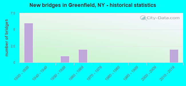
- New bridges - historical statistics
- 61930-1939
- 11950-1959
- 21960-1969
- 22010-2019

- Reconstructed bridges - Historical Statistics
- 21980-1989
- 21990-1999
- 02000-2009
- 12010-2019


- Bridge Condition - Deck
- 33.3%Excellent
- 22.2%Very good
- 22.2%Good
- 11.1%Satisfactory
- 11.1%Fair

- Bridge Condition - Superstructure
- 33.3%Excellent
- 22.2%Very good
- 22.2%Good
- 22.2%Satisfactory

- Bridge Condition - Substructure
- 11.1%Excellent
- 55.6%Good
- 33.3%Satisfactory

- Bridge Condition - Channel
- 62.5%Good
- 25.0%Satisfactory
- 12.5%Fair
Find on map >> Show street view
Structure Number: 100669, Location: RTE 9N 2.3 MI N GRNFLD C (Lat: 43.158683, Lng: -73.858558), Route carried "on" structure: State highway 9N, Year Built: 2016, Status: Open, Structure Length: 1.31m (4.30ft), Average Daily Traffic: 4,522 (year 2018), Truck Traffic: 6%, Average Future Daily Traffic: 4,822 (year 2040), Design Load: HL 93, Features Intersected: KAYADEROSSERAS CK
Minimum Vertical Clearance: 30+ m (98+ ft), Kilometerpoint: 11.971, Lanes on structure: 2, Base Highway Network: Yes, Owner: State Highway Agency, Approaching Roadway Width: 9.4m (30.8ft), Skew: 1 degrees, Material/Design: Concrete, Design/Construction: Frame, Number Of Spans In Main Unit: 1, Length of Maximum Span: 12.8m (42.0ft), Curb-To-Curb Width: 9.1m (29.9ft), Out-to-Out Width: 9.2m (30.2ft)
Condition: Deck: Excellent, Superstructure: Excellent, Substructure: Excellent, Channel: Good, Operating Rating: 81.6 metric tons, Method Used To Determine Operating Rating: Field evaluation and documented engineering judgment, Inventory Rating: 40.8 metric tons, Method Used To Determine Inventory Rating: Field evaluation and documented engineering judgment, Structural Evaluation: Superior to present desirable criteria, Deck Geometry: Meets minimum limits, Waterway Adequacy: Superior to present desirable criteria, Approach Roadway Alignment: Equal to present desirable criteria, Length Of Structure Improvement: 1.31m (4.30ft), Designated Inspection Frequency: Every 24 months, Inspection Date: August 2020, Bridge Improvement Cost: $419,000, Roadway Improvement Cost: $245,000, Total Project Cost: $664,000 ( Estimate for 2021), Wearing Surface/Protective System: Wearing Surface: Bituminous
Find on map >> Show street view
Structure Number: 220272, Location: 4.5 MI NW SARATOGA SPRING (Lat: 43.150681, Lng: -73.888203), Route carried "on" structure: Other road , Year Built: 1960, Year Reconstructed: 2001, Status: Open, Structure Length: 0.94m (3.08ft), Average Daily Traffic: 350 (year 2020), Truck Traffic: 6%, Average Future Daily Traffic: 490 (year 2040), Design Load: HS 25 or greater, Features Intersected: S BR KAYADEROSSERAS CR, Facility Carried by Structure: ALLEN ROAD
Minimum Vertical Clearance: 30+ m (98+ ft), Kilometerpoint: 3.846, Lanes on structure: 2, Owner: County Highway Agency, Approaching Roadway Width: 9.1m (29.9ft), Skew: 3 degrees, Material/Design: Prestressed concrete, Design/Construction: Box Beam or Girders - Multiple, Number Of Spans In Main Unit: 1, Length of Maximum Span: 9.0m (29.5ft), Curb-To-Curb Width: 9.0m (29.5ft), Out-to-Out Width: 10.1m (33.1ft)
Condition: Deck: Good, Superstructure: Very good, Substructure: Satisfactory, Channel: Good, Operating Rating: 79.8 metric tons, Method Used To Determine Operating Rating: Load Factor (LF), Inventory Rating: 48.1 metric tons, Method Used To Determine Inventory Rating: Load Factor (LF), Structural Evaluation: Equal to present minimum criteria, Deck Geometry: Equal to present minimum criteria, Waterway Adequacy: Superior to present desirable criteria, Approach Roadway Alignment: Somewhat better than minimum adequacy, Length Of Structure Improvement: 0.94m (3.08ft), Designated Inspection Frequency: Every 24 months, Inspection Date: July 2021, Bridge Improvement Cost: $397,000, Roadway Improvement Cost: $233,000, Total Project Cost: $630,000 ( Estimate for 2021), Deck Structure Type: Concrete Cast-file-Place, Wearing Surface/Protective System: Wearing Surface: Integral Concrete, Deck Protection: Galvanized Reinforcing
Find on map >> Show street view
Structure Number: 225999, Location: CITY OF SARATOGA SPRINGS (Lat: 43.100186, Lng: -73.792217), Route carried "on" structure: Other road , Year Built: 1957, Status: Open, Structure Length: 1.31m (4.30ft), Average Daily Traffic: 2,957 (year 2017), Truck Traffic: 2%, Average Future Daily Traffic: 4,140 (year 2037), Features Intersected: DELAWARE & HUDSON, Facility Carried by Structure: CLINTON STREET
Minimum Vertical Clearance: 30+ m (98+ ft), Kilometerpoint: 0.579, Lanes on structure: 2, Owner: County Highway Agency, Approaching Roadway Width: 7.0m (23.0ft), Material/Design: Steel, Design/Construction: Stringer/Multi-beam, Number Of Spans In Main Unit: 1, Length of Maximum Span: 11.8m (38.7ft), Curb or Sidewalk Widths: Left: 0.8m (2.6ft), Right: 0.8m (2.6ft), Curb-To-Curb Width: 7.9m (25.9ft), Out-to-Out Width: 10.1m (33.1ft)
Condition: Deck: Satisfactory, Superstructure: Satisfactory, Substructure: Satisfactory, Operating Rating: 59.9 metric tons, Method Used To Determine Operating Rating: Load Factor (LF), Inventory Rating: 35.4 metric tons, Method Used To Determine Inventory Rating: Load Factor (LF), Structural Evaluation: Equal to present minimum criteria, Deck Geometry: High priority of corrective action, Underclear: Meets minimum limits, Approach Roadway Alignment: Equal to present minimum criteria, Length Of Structure Improvement: 1.31m (4.30ft), Designated Inspection Frequency: Every 24 months, Inspection Date: August 2020, Bridge Improvement Cost: $750,000, Roadway Improvement Cost: $439,000, Total Project Cost: $1,189,000 ( Estimate for 2021), Deck Structure Type: Concrete Cast-file-Place, Wearing Surface/Protective System: Wearing Surface: Monolithic Concrete
Find on map >> Show street view
Structure Number: 330416, Location: .5 MI SW MIDDLE GROVE (Lat: 43.085194, Lng: -73.922900), Route carried "on" structure: County highway , Year Built: 1930, Year Reconstructed: 2018, Status: Open, Structure Length: 1.89m (6.20ft), Average Daily Traffic: 2,555 (year 2019), Truck Traffic: 7%, Average Future Daily Traffic: 3,577 (year 2039), Design Load: HL 93, Features Intersected: KAYADEROSSERAS CK, Facility Carried by Structure: CR21MIDDLE GRV RD
Minimum Vertical Clearance: 30+ m (98+ ft), Kilometerpoint: 5.213, Lanes on structure: 2, Owner: County Highway Agency, Approaching Roadway Width: 8.5m (27.9ft), Material/Design: Steel, Design/Construction: Stringer/Multi-beam, Number Of Spans In Main Unit: 1, Length of Maximum Span: 18.2m (59.7ft), Curb-To-Curb Width: 8.5m (27.9ft), Out-to-Out Width: 9.5m (31.2ft)
Condition: Deck: Excellent, Superstructure: Excellent, Substructure: Good, Channel: Good, Operating Rating: 78.9 metric tons, Method Used To Determine Operating Rating: Load Factor (LF), Inventory Rating: 47.2 metric tons, Method Used To Determine Inventory Rating: Load Factor (LF), Structural Evaluation: Better than present minimum criteria, Deck Geometry: Meets minimum limits, Waterway Adequacy: Superior to present desirable criteria, Approach Roadway Alignment: Equal to present desirable criteria, Length Of Structure Improvement: 1.88m (6.17ft), Designated Inspection Frequency: Every 24 months, Inspection Date: April 2020, Bridge Improvement Cost: $610,000, Roadway Improvement Cost: $357,000, Total Project Cost: $968,000 ( Estimate for 2021), Deck Structure Type: Concrete Cast-file-Place, Wearing Surface/Protective System: Wearing Surface: Integral Concrete, Deck Protection: Epoxy Coated Reinforcing
Find on map >> Show street view
Structure Number: 33042, Location: 3.5 MI E LAKE DESOLATION (Lat: 43.137983, Lng: -73.877639), Route carried "on" structure: Other road , Year Built: 1931, Year Reconstructed: 1995, Status: Open, Structure Length: 1.16m (3.81ft), Average Daily Traffic: 658 (year 2017), Truck Traffic: 6%, Average Future Daily Traffic: 921 (year 2037), Design Load: HS 20+Mod, Features Intersected: KAYADEROSSERAS CK, Facility Carried by Structure: BOCKES ROAD
Minimum Vertical Clearance: 30+ m (98+ ft), Kilometerpoint: 1.014, Lanes on structure: 2, Owner: County Highway Agency, Approaching Roadway Width: 7.3m (24.0ft), Skew: 1 degrees, Material/Design: Prestressed concrete, Design/Construction: Box Beam or Girders - Multiple, Number Of Spans In Main Unit: 1, Length of Maximum Span: 10.6m (34.8ft), Curb-To-Curb Width: 7.2m (23.6ft), Out-to-Out Width: 7.9m (25.9ft)
Condition: Deck: Fair, Superstructure: Good, Substructure: Good, Channel: Satisfactory, Operating Rating: 89.8 metric tons, Method Used To Determine Operating Rating: Load Factor (LF), Inventory Rating: 39.0 metric tons, Method Used To Determine Inventory Rating: Load Factor (LF), Structural Evaluation: Better than present minimum criteria, Deck Geometry: Meets minimum limits, Waterway Adequacy: Superior to present desirable criteria, Approach Roadway Alignment: Equal to present desirable criteria, Length Of Structure Improvement: 1.15m (3.77ft), Designated Inspection Frequency: Every 24 months, Inspection Date: August 2020, Bridge Improvement Cost: $272,000, Roadway Improvement Cost: $160,000, Total Project Cost: $432,000 ( Estimate for 2021), Deck Structure Type: Concrete Cast-file-Place, Wearing Surface/Protective System: Wearing Surface: Integral Concrete
Find on map >> Show street view
Structure Number: 330453, Location: 2.0 MI W GREENFIELD CTR (Lat: 43.126156, Lng: -73.891936), Route carried "on" structure: County highway , Year Built: 1937, Year Reconstructed: 1989, Status: Open, Structure Length: 1.40m (4.59ft), Average Daily Traffic: 1,354 (year 2017), Truck Traffic: 8%, Average Future Daily Traffic: 1,896 (year 2037), Design Load: HS 20, Features Intersected: KAYADEROSSERAS CK, Facility Carried by Structure: COUNTY ROAD 19
Minimum Vertical Clearance: 30+ m (98+ ft), Kilometerpoint: 4.940, Lanes on structure: 2, Owner: County Highway Agency, Approaching Roadway Width: 7.3m (24.0ft), Skew: 2 degrees, Material/Design: Steel, Design/Construction: Stringer/Multi-beam, Number Of Spans In Main Unit: 1, Length of Maximum Span: 13.1m (43.0ft), Curb-To-Curb Width: 7.3m (24.0ft), Out-to-Out Width: 8.0m (26.2ft)
Condition: Deck: Very good, Superstructure: Good, Substructure: Good, Channel: Good, Operating Rating: 81.9 metric tons, Method Used To Determine Operating Rating: Field evaluation and documented engineering judgment, Inventory Rating: 32.7 metric tons, Method Used To Determine Inventory Rating: Field evaluation and documented engineering judgment, Structural Evaluation: Better than present minimum criteria, Deck Geometry: Meets minimum limits, Waterway Adequacy: Superior to present desirable criteria, Approach Roadway Alignment: Better than present minimum criteria, Length Of Structure Improvement: 1.40m (4.59ft), Designated Inspection Frequency: Every 24 months, Inspection Date: September 2020, Bridge Improvement Cost: $332,000, Roadway Improvement Cost: $195,000, Total Project Cost: $527,000 ( Estimate for 2021), Deck Structure Type: Other, Wearing Surface/Protective System: Wearing Surface: Bituminous
Find on map >> Show street view
Structure Number: 330454, Location: 3.3 ML N ROCK CITY FALLS (Lat: 43.108061, Lng: -73.906353), Route carried "on" structure: Other road , Year Built: 1967, Status: Open, Structure Length: 1.22m (4.00ft), Average Daily Traffic: 517 (year 2017), Truck Traffic: 6%, Average Future Daily Traffic: 724 (year 2037), Design Load: H 20, Features Intersected: KAYADEROSSERAS CK, Facility Carried by Structure: SAND HILL ROAD
Minimum Vertical Clearance: 30+ m (98+ ft), Kilometerpoint: 2.092, Lanes on structure: 2, Owner: County Highway Agency, Approaching Roadway Width: 6.4m (21.0ft), Material/Design: Prestressed concrete, Design/Construction: Box Beam or Girders - Multiple, Number Of Spans In Main Unit: 1, Length of Maximum Span: 11.2m (36.7ft), Curb-To-Curb Width: 9.1m (29.9ft), Out-to-Out Width: 9.8m (32.2ft)
Condition: Deck: Good, Superstructure: Satisfactory, Substructure: Good, Channel: Fair, Operating Rating: 74.4 metric tons, Method Used To Determine Operating Rating: Load Factor (LF), Inventory Rating: 44.5 metric tons, Method Used To Determine Inventory Rating: Load Factor (LF), Structural Evaluation: Equal to present minimum criteria, Deck Geometry: Equal to present minimum criteria, Waterway Adequacy: Superior to present desirable criteria, Approach Roadway Alignment: Better than present minimum criteria, Length Of Structure Improvement: 1.21m (3.97ft), Designated Inspection Frequency: Every 24 months, Inspection Date: September 2020, Bridge Improvement Cost: $526,000, Roadway Improvement Cost: $308,000, Total Project Cost: $833,000 ( Estimate for 2021), Wearing Surface/Protective System: Wearing Surface: Bituminous
Find on map >> Show street view
Structure Number: 330455, Location: .5 MI NW MIDDLE GROVE (Lat: 43.091489, Lng: -73.921356), Route carried "on" structure: County highway , Year Built: 2016, Status: Open, Structure Length: 2.10m (6.89ft), Average Daily Traffic: 967 (year 2017), Truck Traffic: 6%, Average Future Daily Traffic: 1,354 (year 2037), Design Load: H 20, Features Intersected: KAYADEROSSERAS CK, Facility Carried by Structure: CR12 L DESOLA RD
Minimum Vertical Clearance: 30+ m (98+ ft), Kilometerpoint: 0.354, Lanes on structure: 2, Owner: County Highway Agency, Approaching Roadway Width: 7.3m (24.0ft), Material/Design: Steel, Design/Construction: Stringer/Multi-beam, Number Of Spans In Main Unit: 1, Length of Maximum Span: 20.1m (65.9ft), Curb-To-Curb Width: 7.3m (24.0ft), Out-to-Out Width: 8.3m (27.2ft)
Condition: Deck: Excellent, Superstructure: Excellent, Substructure: Good, Channel: Good, Inventory Rating: 61.7 metric tons, Method Used To Determine Inventory Rating: Load Factor (LF), Structural Evaluation: Better than present minimum criteria, Deck Geometry: Meets minimum limits, Waterway Adequacy: Superior to present desirable criteria, Approach Roadway Alignment: Equal to present minimum criteria, Length Of Structure Improvement: 2.10m (6.89ft), Designated Inspection Frequency: Every 24 months, Inspection Date: April 2020, Bridge Improvement Cost: $547,000, Roadway Improvement Cost: $320,000, Total Project Cost: $867,000 ( Estimate for 2021), Deck Structure Type: Concrete Cast-file-Place, Wearing Surface/Protective System: Wearing Surface: Integral Concrete, Deck Protection: Epoxy Coated Reinforcing
Find on map >> Show street view
Structure Number: 336418, Location: 4 MI NW SARATOGA SPRINGS (Lat: 43.166969, Lng: -73.855256), Route carried "on" structure: County highway , Year Built: 1938, Year Reconstructed: 1989, Status: Open, Structure Length: 0.85m (2.79ft), Average Daily Traffic: 1,006 (year 2018), Truck Traffic: 6%, Average Future Daily Traffic: 1,408 (year 2038), Design Load: HS 20, Features Intersected: KAYADEROSSERAS CK, Facility Carried by Structure: SPIER FALLS ROAD
Minimum Vertical Clearance: 30+ m (98+ ft), Kilometerpoint: 0.531, Lanes on structure: 2, Owner: County Highway Agency, Approaching Roadway Width: 7.9m (25.9ft), Skew: 3 degrees, Material/Design: Prestressed concrete, Design/Construction: Box Beam or Girders - Multiple, Number Of Spans In Main Unit: 1, Length of Maximum Span: 7.9m (25.9ft), Curb-To-Curb Width: 8.5m (27.9ft), Out-to-Out Width: 9.3m (30.5ft)
Condition: Deck: Very good, Superstructure: Very good, Substructure: Satisfactory, Channel: Satisfactory, Inventory Rating: 74.4 metric tons, Method Used To Determine Inventory Rating: Load Factor (LF), Structural Evaluation: Equal to present minimum criteria, Deck Geometry: Somewhat better than minimum adequacy, Waterway Adequacy: Superior to present desirable criteria, Approach Roadway Alignment: Better than present minimum criteria, Length Of Structure Improvement: 0.85m (2.79ft), Designated Inspection Frequency: Every 24 months, Inspection Date: August 2020, Bridge Improvement Cost: $540,000, Roadway Improvement Cost: $316,000, Total Project Cost: $856,000 ( Estimate for 2021), Wearing Surface/Protective System: Wearing Surface: Bituminous
Find on map >> Show street view
Structure Number: 700667, Location: 3.1 MI NW JCT RTS 9 & 9N (Lat: 43.100283, Lng: -73.839014), Route carried "under" structure: State highway 9N, Year Built: 1934, Structure Length: 0. m, Average Daily Traffic: 7,368 (year 2000), Features Intersected: RTE 9N, Facility Carried by Structure: DELAWARE & HUDSON
Minimum Vertical Clearance: 4.47m (14.67ft), Kilometerpoint: 3.894, Lanes under structure: 2, Material/Design: Steel, Design/Construction: Stringer/Multi-beam, Length of Maximum Span: 11.2m (36.7ft)
Find on map >> Show street view
Structure Number: 700668, Location: RTE 9N 1.9 MI N GRNFLD C (Lat: 43.152722, Lng: -73.855156), Route carried "under" structure: State highway 9N, Year Built: 1939, Structure Length: 0. m, Average Daily Traffic: 4,535 (year 1998), Features Intersected: RTE 9N, Facility Carried by Structure: DELAWARE & HUDSON
Minimum Vertical Clearance: 4.44m (14.57ft), Kilometerpoint: 10.346, Lanes under structure: 2, Material/Design: Steel, Design/Construction: Girder and Floorbeam System, Length of Maximum Span: 20.4m (66.9ft)