Bridge Statistics for Hitchcock, Texas (TX)
Condition, Traffic, Stress, Structural Evaluation, Project Costs
- National Bridge Inventory (NBI) Statistics
- 35Number of bridges
- 735ft / 224mTotal length
- $2,286,000Total costs
- 313,832Total average daily traffic
- 14,534Total average daily truck traffic
- National Bridge Inventory (NBI) Registered Bridges for Hitchcock
- No street view available for this location
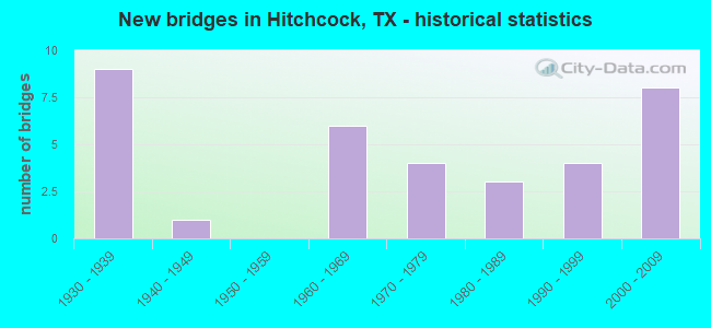
- New bridges - historical statistics
- 91930-1939
- 11940-1949
- 61960-1969
- 41970-1979
- 31980-1989
- 41990-1999
- 82000-2009

- Reconstructed bridges - Historical Statistics
- 61950-1959
- 11960-1969
- 01970-1979
- 41980-1989


- Bridge Condition - Deck
- 12.0%Very good
- 44.0%Good
- 44.0%Satisfactory

- Bridge Condition - Superstructure
- 16.0%Very good
- 44.0%Good
- 24.0%Satisfactory
- 16.0%Fair

- Bridge Condition - Substructure
- 4.0%Very good
- 52.0%Good
- 36.0%Satisfactory
- 8.0%Poor

- Bridge Condition - Channel
- 3.2%Very good
- 61.3%Good
- 32.3%Satisfactory
- 3.2%Fair

- Bridge Condition - Culverts
- 33.3%Good
- 44.4%Satisfactory
- 22.2%Fair
Find on map >> Show street view
Structure Number: 120850019204015, Location: 1.55 MI SE OF FM 646 (Lat: 29.362083, Lng: -95.058083), Route carried "on" structure: State highway 6, Year Built: 1931, Year Reconstructed: 1964, Status: Open, Structure Length: 0.76m (2.49ft), Average Daily Traffic: 9,003 (year 2020), Truck Traffic: 6%, Average Future Daily Traffic: 10,670 (year 2033), Design Load: H 15, Features Intersected: DRAINAGE DITCH
Minimum Vertical Clearance: 30+ m (98+ ft), Kilometerpoint: 14.338, Lanes on structure: 5, Owner: State Highway Agency, Approaching Roadway Width: 23.8m (78.1ft), Skew: 9 degrees, Material/Design: Concrete, Design/Construction: Culvert, Number Of Spans In Main Unit: 2, Length of Maximum Span: 3.0m (9.8ft), Curb-To-Curb Width: 23.2m (76.1ft), Out-to-Out Width: 24.9m (81.7ft)
Condition: Channel: Good, Culverts: Good, Operating Rating: 39.9 metric tons, Method Used To Determine Operating Rating: Load Factor (LF), Inventory Rating: 23.6 metric tons, Method Used To Determine Inventory Rating: Load Factor (LF), Structural Evaluation: Somewhat better than minimum adequacy, Deck Geometry: Better than present minimum criteria, Waterway Adequacy: Equal to present minimum criteria, Approach Roadway Alignment: Equal to present desirable criteria, Designated Inspection Frequency: Every 24 months, Inspection Date: September 2020, Deck Structure Type: Concrete Cast-file-Place, Wearing Surface/Protective System: Wearing Surface: Bituminous
Find on map >> Show street view
Structure Number: 120850019204016, Location: 1.00 MI NW OF FM 2004 (Lat: 29.357789, Lng: -95.045508), Route carried "on" structure: State highway 6, Year Built: 1931, Year Reconstructed: 1964, Status: Open, Structure Length: 1.04m (3.41ft), Average Daily Traffic: 9,247 (year 2020), Truck Traffic: 6%, Average Future Daily Traffic: 12,530 (year 2033), Design Load: HS 20, Features Intersected: DRAINAGE DITCH
Minimum Vertical Clearance: 30+ m (98+ ft), Kilometerpoint: 15.633, Lanes on structure: 5, Owner: State Highway Agency, Approaching Roadway Width: 23.8m (78.1ft), Material/Design: Concrete, Design/Construction: Culvert, Number Of Spans In Main Unit: 3, Length of Maximum Span: 3.0m (9.8ft), Curb-To-Curb Width: 23.2m (76.1ft), Out-to-Out Width: 24.8m (81.4ft)
Condition: Channel: Fair, Culverts: Fair, Operating Rating: 39.9 metric tons, Method Used To Determine Operating Rating: Load Factor (LF), Inventory Rating: 23.6 metric tons, Method Used To Determine Inventory Rating: Load Factor (LF), Structural Evaluation: Somewhat better than minimum adequacy, Deck Geometry: Better than present minimum criteria, Waterway Adequacy: Equal to present minimum criteria, Approach Roadway Alignment: Equal to present desirable criteria, Designated Inspection Frequency: Every 24 months, Inspection Date: September 2020, Deck Structure Type: Concrete Cast-file-Place, Wearing Surface/Protective System: Wearing Surface: Bituminous
Find on map >> Show street view
Structure Number: 120850019204017, Location: 0.25 MI NW OF FM 2004 (Lat: 29.354139, Lng: -95.034783), Route carried "on" structure: State highway 6, Year Built: 1931, Year Reconstructed: 1964, Status: Open, Structure Length: 1.04m (3.41ft), Average Daily Traffic: 9,247 (year 2020), Truck Traffic: 6%, Average Future Daily Traffic: 12,530 (year 2033), Design Load: H 15, Features Intersected: DRAINAGE DITCH
Minimum Vertical Clearance: 30+ m (98+ ft), Kilometerpoint: 16.756, Lanes on structure: 5, Owner: State Highway Agency, Approaching Roadway Width: 23.8m (78.1ft), Material/Design: Concrete, Design/Construction: Culvert, Number Of Spans In Main Unit: 3, Length of Maximum Span: 3.0m (9.8ft), Curb-To-Curb Width: 23.5m (77.1ft), Out-to-Out Width: 25.0m (82.0ft)
Condition: Channel: Satisfactory, Culverts: Satisfactory, Operating Rating: 39.9 metric tons, Method Used To Determine Operating Rating: Load Factor (LF), Inventory Rating: 23.6 metric tons, Method Used To Determine Inventory Rating: Load Factor (LF), Structural Evaluation: Somewhat better than minimum adequacy, Deck Geometry: Better than present minimum criteria, Waterway Adequacy: Equal to present minimum criteria, Approach Roadway Alignment: Equal to present desirable criteria, Designated Inspection Frequency: Every 24 months, Inspection Date: September 2020, Deck Structure Type: Concrete Cast-file-Place, Wearing Surface/Protective System: Wearing Surface: Bituminous
Find on map >> Show street view
Structure Number: 120850019204018, Location: 0.35 MI SE OF FM 2004 (Lat: 29.351192, Lng: -95.025303), Route carried "on" structure: State highway 6, Year Built: 1931, Year Reconstructed: 1961, Status: Open, Structure Length: 3.29m (10.79ft), Average Daily Traffic: 12,772 (year 2020), Truck Traffic: 6%, Average Future Daily Traffic: 15,930 (year 2033), Features Intersected: COW GULLY
Minimum Vertical Clearance: 30+ m (98+ ft), Kilometerpoint: 17.743, Lanes on structure: 5, Owner: State Highway Agency, Approaching Roadway Width: 23.8m (78.1ft), Material/Design: Concrete, Design/Construction: Slab, Number Of Spans In Main Unit: 6, Length of Maximum Span: 5.5m (18.0ft), Curb-To-Curb Width: 23.5m (77.1ft), Out-to-Out Width: 25.0m (82.0ft)
Condition: Deck: Good, Superstructure: Good, Substructure: Satisfactory, Channel: Good, Operating Rating: 60.8 metric tons, Method Used To Determine Operating Rating: Load Factor (LF), Inventory Rating: 36.3 metric tons, Method Used To Determine Inventory Rating: Load Factor (LF), Structural Evaluation: Equal to present minimum criteria, Deck Geometry: Better than present minimum criteria, Waterway Adequacy: Equal to present minimum criteria, Approach Roadway Alignment: Equal to present desirable criteria, Designated Inspection Frequency: Every 24 months, Inspection Date: September 2020, Deck Structure Type: Concrete Cast-file-Place, Wearing Surface/Protective System: Wearing Surface: Bituminous
Find on map >> Show street view
Structure Number: 120850019204019, Location: 1.76 MI SE OF FM 519 (Lat: 29.340342, Lng: -94.989408), Route carried "on" structure: State highway 6, Year Built: 1931, Year Reconstructed: 1994, Status: Open, Structure Length: 0.70m (2.30ft), Average Daily Traffic: 7,009 (year 2020), Truck Traffic: 6%, Average Future Daily Traffic: 10,130 (year 2033), Design Load: H 15, Features Intersected: DRAINAGE DITCH
Minimum Vertical Clearance: 30+ m (98+ ft), Kilometerpoint: 21.436, Lanes on structure: 5, Owner: State Highway Agency, Approaching Roadway Width: 23.8m (78.1ft), Material/Design: Concrete, Design/Construction: Culvert, Number Of Spans In Main Unit: 2, Length of Maximum Span: 3.0m (9.8ft), Curb-To-Curb Width: 23.8m (78.1ft), Out-to-Out Width: 29.9m (98.1ft)
Condition: Channel: Satisfactory, Culverts: Satisfactory, Operating Rating: 39.9 metric tons, Method Used To Determine Operating Rating: Load Factor (LF), Inventory Rating: 23.6 metric tons, Method Used To Determine Inventory Rating: Load Factor (LF), Structural Evaluation: Somewhat better than minimum adequacy, Deck Geometry: Better than present minimum criteria, Waterway Adequacy: Equal to present minimum criteria, Approach Roadway Alignment: Equal to present desirable criteria, Designated Inspection Frequency: Every 24 months, Inspection Date: September 2020, Deck Structure Type: Concrete Cast-file-Place, Wearing Surface/Protective System: Wearing Surface: Bituminous
Find on map >> Show street view
Structure Number: 12085001920402, Location: 2.50 MI SE OF FM 519 (Lat: 29.336906, Lng: -94.977742), Route carried "on" structure: State highway 6, Year Built: 1931, Year Reconstructed: 1961, Status: Open, Structure Length: 0.70m (2.30ft), Average Daily Traffic: 7,009 (year 2020), Truck Traffic: 6%, Average Future Daily Traffic: 10,130 (year 2033), Design Load: H 15, Features Intersected: DRAINAGE DITCH
Minimum Vertical Clearance: 30+ m (98+ ft), Kilometerpoint: 22.634, Lanes on structure: 5, Owner: State Highway Agency, Approaching Roadway Width: 23.8m (78.1ft), Material/Design: Concrete, Design/Construction: Culvert, Number Of Spans In Main Unit: 2, Length of Maximum Span: 3.0m (9.8ft), Curb-To-Curb Width: 23.0m (75.5ft), Out-to-Out Width: 24.8m (81.4ft)
Condition: Channel: Satisfactory, Culverts: Satisfactory, Operating Rating: 39.9 metric tons, Method Used To Determine Operating Rating: Load Factor (LF), Inventory Rating: 23.6 metric tons, Method Used To Determine Inventory Rating: Load Factor (LF), Structural Evaluation: Somewhat better than minimum adequacy, Deck Geometry: Equal to present minimum criteria, Waterway Adequacy: Equal to present minimum criteria, Approach Roadway Alignment: Equal to present desirable criteria, Designated Inspection Frequency: Every 24 months, Inspection Date: September 2020, Deck Structure Type: Concrete Cast-file-Place, Wearing Surface/Protective System: Wearing Surface: Bituminous
Find on map >> Show street view
Structure Number: 120850019204021, Location: 2.80 MI SE OF FM 519 (Lat: 29.335219, Lng: -94.972236), Route carried "on" structure: State highway 6, Year Built: 1931, Year Reconstructed: 1961, Status: Open, Structure Length: 1.04m (3.41ft), Average Daily Traffic: 7,009 (year 2020), Truck Traffic: 6%, Average Future Daily Traffic: 10,130 (year 2033), Design Load: H 15, Features Intersected: DRAINAGE DITCH
Minimum Vertical Clearance: 30+ m (98+ ft), Kilometerpoint: 23.175, Lanes on structure: 5, Owner: State Highway Agency, Approaching Roadway Width: 23.8m (78.1ft), Material/Design: Concrete, Design/Construction: Culvert, Number Of Spans In Main Unit: 3, Length of Maximum Span: 3.0m (9.8ft), Curb-To-Curb Width: 23.5m (77.1ft), Out-to-Out Width: 25.0m (82.0ft)
Condition: Channel: Satisfactory, Culverts: Fair, Operating Rating: 39.9 metric tons, Method Used To Determine Operating Rating: Load Factor (LF), Inventory Rating: 23.6 metric tons, Method Used To Determine Inventory Rating: Load Factor (LF), Structural Evaluation: Somewhat better than minimum adequacy, Deck Geometry: Better than present minimum criteria, Waterway Adequacy: Equal to present minimum criteria, Approach Roadway Alignment: Equal to present desirable criteria, Designated Inspection Frequency: Every 24 months, Inspection Date: September 2020, Deck Structure Type: Concrete Cast-file-Place, Wearing Surface/Protective System: Wearing Surface: Bituminous
Find on map >> Show street view
Structure Number: 120850019204022, Location: 1.0 MI W OF IH 45 (Lat: 29.332064, Lng: -94.949800), Route carried "on" structure: State highway 6, Year Built: 1999, Status: Open, Structure Length: 0.70m (2.30ft), Average Daily Traffic: 9,393 (year 2020), Truck Traffic: 6%, Average Future Daily Traffic: 11,860 (year 2033), Design Load: HS 20, Features Intersected: DRAINAGE DITCH
Minimum Vertical Clearance: 30+ m (98+ ft), Kilometerpoint: 25.412, Lanes on structure: 5, Owner: State Highway Agency, Approaching Roadway Width: 24.4m (80.1ft), Material/Design: Concrete, Design/Construction: Culvert, Number Of Spans In Main Unit: 2, Length of Maximum Span: 3.0m (9.8ft), Curb-To-Curb Width: 25.2m (82.7ft), Out-to-Out Width: 26.0m (85.3ft)
Condition: Channel: Good, Culverts: Good, Operating Rating: 39.9 metric tons, Method Used To Determine Operating Rating: Load Factor (LF), Inventory Rating: 23.6 metric tons, Method Used To Determine Inventory Rating: Load Factor (LF), Structural Evaluation: Somewhat better than minimum adequacy, Deck Geometry: Superior to present desirable criteria, Waterway Adequacy: Equal to present minimum criteria, Approach Roadway Alignment: Equal to present desirable criteria, Designated Inspection Frequency: Every 48 months, Inspection Date: August 2020
Find on map >> Show street view
Structure Number: 120850019204026, Location: 0.75 MI W OF IH 45 (Lat: 29.331836, Lng: -94.944969), Route carried "on" structure: State highway 6, Year Built: 1964, Year Reconstructed: 1972, Status: Open, Structure Length: 13.41m (44.00ft), Average Daily Traffic: 9,393 (year 2020), Truck Traffic: 6%, Average Future Daily Traffic: 11,860 (year 2033), Design Load: HS 20, Features Intersected: HIGHLAND BAYOU
Minimum Vertical Clearance: 30+ m (98+ ft), Kilometerpoint: 25.764, Lanes on structure: 4, Owner: State Highway Agency, Approaching Roadway Width: 26.5m (86.9ft), Skew: 30 degrees, Material/Design: Concrete, Design/Construction: Stringer/Multi-beam, Number Of Spans In Main Unit: 11, Length of Maximum Span: 12.2m (40.0ft), Curb-To-Curb Width: 26.8m (87.9ft), Out-to-Out Width: 28.0m (91.9ft)
Condition: Deck: Satisfactory, Superstructure: Fair, Substructure: Satisfactory, Channel: Satisfactory, Operating Rating: 41.7 metric tons, Method Used To Determine Operating Rating: Load Factor (LF), Inventory Rating: 25.4 metric tons, Method Used To Determine Inventory Rating: Load Factor (LF), Structural Evaluation: Somewhat better than minimum adequacy, Deck Geometry: Superior to present desirable criteria, Waterway Adequacy: Equal to present desirable criteria, Approach Roadway Alignment: Equal to present desirable criteria, Designated Inspection Frequency: Every 24 months, Underwater Inspection Frequency: Every 60 months, Inspection Date: September 2020, Underwater Inspection Date: November 2016, Deck Structure Type: Concrete Cast-file-Place, Wearing Surface/Protective System: Wearing Surface: Bituminous
Find on map >> Show street view
Structure Number: 120850019204031, Location: 0.60 MI NW OF FM 2004 (Lat: 29.355639, Lng: -95.039208), Route carried "on" structure: State highway 6, Year Built: 1977, Status: Open, Structure Length: 7.65m (25.10ft), Average Daily Traffic: 9,247 (year 2020), Truck Traffic: 6%, Average Future Daily Traffic: 12,530 (year 2033), Design Load: HS 20, Features Intersected: HIGHLAND BAYOU D.C.
Minimum Vertical Clearance: 30+ m (98+ ft), Kilometerpoint: 16.359, Lanes on structure: 5, Owner: State Highway Agency, Approaching Roadway Width: 23.8m (78.1ft), Skew: 2 degrees, Material/Design: Concrete, Design/Construction: Stringer/Multi-beam, Number Of Spans In Main Unit: 6, Length of Maximum Span: 12.8m (42.0ft), Curb-To-Curb Width: 25.5m (83.7ft), Out-to-Out Width: 26.1m (85.6ft)
Condition: Deck: Good, Superstructure: Good, Substructure: Good, Channel: Good, Operating Rating: 68.0 metric tons, Method Used To Determine Operating Rating: Load Factor (LF), Inventory Rating: 40.8 metric tons, Method Used To Determine Inventory Rating: Load Factor (LF), Structural Evaluation: Better than present minimum criteria, Deck Geometry: Superior to present desirable criteria, Waterway Adequacy: Equal to present minimum criteria, Approach Roadway Alignment: Equal to present desirable criteria, Designated Inspection Frequency: Every 24 months, Underwater Inspection Frequency: Every 60 months, Inspection Date: September 2020, Underwater Inspection Date: November 2017, Deck Structure Type: Concrete Cast-file-Place
Find on map >> Show street view
Structure Number: 120850050001001, Location: 2.20 MI SE OF SH 146 (Lat: 29.307047, Lng: -94.905758), Route carried "on" structure: Interstate 45, Year Built: 1939, Year Reconstructed: 1987, Status: Open, Structure Length: 39.84m (130.71ft), Average Daily Traffic: 33,950 (year 2013), Truck Traffic: 4%, Average Future Daily Traffic: 47,540 (year 2033), Design Load: H 15, Features Intersected: BNSF RR
Minimum Vertical Clearance: 30+ m (98+ ft), Kilometerpoint: 23.781, Lanes on structure: 3, Owner: State Highway Agency, Approaching Roadway Width: 17.1m (56.1ft), Material/Design: Steel, Design/Construction: Stringer/Multi-beam, Number Of Spans In Main Unit: 5, Number Of Approach Spans: 27, Length of Maximum Span: 13.7m (44.9ft), Curb-To-Curb Width: 16.9m (55.4ft), Out-to-Out Width: 18.2m (59.7ft)
Condition: Deck: Satisfactory, Superstructure: Fair, Substructure: Poor, Operating Rating: 43.5 metric tons, Method Used To Determine Operating Rating: Load Factor (LF), Inventory Rating: 26.3 metric tons, Method Used To Determine Inventory Rating: Load Factor (LF), Structural Evaluation: Meets minimum limits, Deck Geometry: Equal to present minimum criteria, Underclear: Meets minimum limits, Approach Roadway Alignment: Equal to present desirable criteria, Length Of Structure Improvement: 39.84m (130.71ft), Designated Inspection Frequency: Every 24 months, Critical Feature Inspection Frequency: Every 24 months, Inspection Date: October 2020, Critical Feature Inspection Date: June 2021, Bridge Improvement Cost: $1,464,000, Roadway Improvement Cost: $366,000, Total Project Cost: $1,830,000, Deck Structure Type: Concrete Cast-file-Place, Wearing Surface/Protective System: Wearing Surface: Bituminous
Find on map >> Show street view
Structure Number: 120850050001132, Location: 2.20 MI SE OF SH 146 (Lat: 29.306997, Lng: -94.905961), Route carried "on" structure: Interstate 45, Year Built: 1965, Year Reconstructed: 1987, Status: Open, Structure Length: 45.48m (149.21ft), Average Daily Traffic: 33,950 (year 2013), Truck Traffic: 4%, Average Future Daily Traffic: 47,540 (year 2033), Design Load: HS 20, Features Intersected: BNSF RR
Minimum Vertical Clearance: 30+ m (98+ ft), Kilometerpoint: 23.768, Lanes on structure: 3, Owner: State Highway Agency, Approaching Roadway Width: 17.1m (56.1ft), Material/Design: Steel, Design/Construction: Stringer/Multi-beam, Number Of Spans In Main Unit: 2, Number Of Approach Spans: 23, Length of Maximum Span: 18.3m (60.0ft), Curb-To-Curb Width: 16.8m (55.1ft), Out-to-Out Width: 17.7m (58.1ft)
Condition: Deck: Satisfactory, Superstructure: Fair, Substructure: Poor, Operating Rating: 41.7 metric tons, Method Used To Determine Operating Rating: Load Factor (LF), Inventory Rating: 24.5 metric tons, Method Used To Determine Inventory Rating: Load Factor (LF), Structural Evaluation: Meets minimum limits, Deck Geometry: Equal to present minimum criteria, Underclear: Meets minimum limits, Approach Roadway Alignment: Equal to present desirable criteria, Designated Inspection Frequency: Every 24 months, Critical Feature Inspection Frequency: Every 24 months, Inspection Date: October 2020, Critical Feature Inspection Date: November 2020, Deck Structure Type: Concrete Cast-file-Place
Find on map >> Show street view
Structure Number: 120850050001286, Location: 0.80 MI SE of SH 6 (Lat: 29.322456, Lng: -94.922994), Route carried "on" structure: Interstate 45, Year Built: 1987, Status: Open, Structure Length: 2.59m (8.50ft), Average Daily Traffic: 67,910 (year 2013), Truck Traffic: 4%, Average Future Daily Traffic: 95,080 (year 2033), Design Load: HS 20, Features Intersected: TIDAL INTERCHANGE
Minimum Vertical Clearance: 30+ m (98+ ft), Kilometerpoint: 26.287, Lanes on structure: 7, Owner: State Highway Agency, Approaching Roadway Width: 33.8m (110.9ft), Skew: 30 degrees, Material/Design: Prestressed concrete, Design/Construction: Stringer/Multi-beam, Number Of Spans In Main Unit: 1, Length of Maximum Span: 25.9m (85.0ft), Curb-To-Curb Width: 37.9m (124.3ft), Out-to-Out Width: 39.4m (129.3ft)
Condition: Deck: Good, Superstructure: Good, Substructure: Good, Channel: Good, Operating Rating: 54.4 metric tons, Method Used To Determine Operating Rating: Assigned rating based on Load Factor Design (LFD) reported in metric tons, Inventory Rating: 32.7 metric tons, Method Used To Determine Inventory Rating: Assigned rating based on Load Factor Design (LFD) reported in metric tons, Structural Evaluation: Better than present minimum criteria, Deck Geometry: Superior to present desirable criteria, Waterway Adequacy: Equal to present minimum criteria, Approach Roadway Alignment: Equal to present desirable criteria, Designated Inspection Frequency: Every 24 months, Inspection Date: August 2020, Deck Structure Type: Concrete Cast-file-Place, Wearing Surface/Protective System: Wearing Surface: Bituminous
Find on map >> Show street view
Structure Number: 120850050001353, Location: 0.80 MI SE OF SH 6 (Lat: 29.322800, Lng: -94.922794), Route carried "on" structure: ServiceInterstate 45, Year Built: 1999, Status: Open, Structure Length: 1.52m (4.99ft), Average Daily Traffic: 100 (year 2013), Truck Traffic: 6%, Average Future Daily Traffic: 140 (year 2033), Design Load: HS 20, Features Intersected: TIDAL INTERCHANGE
Minimum Vertical Clearance: 30+ m (98+ ft), Kilometerpoint: 26.287, Lanes on structure: 2, Owner: State Highway Agency, Approaching Roadway Width: 8.5m (27.9ft), Material/Design: Prestressed concrete, Design/Construction: Box Beam or Girders - Multiple, Number Of Spans In Main Unit: 1, Length of Maximum Span: 15.2m (49.9ft), Curb-To-Curb Width: 11.1m (36.4ft), Out-to-Out Width: 11.8m (38.7ft)
Condition: Deck: Good, Superstructure: Very good, Substructure: Good, Channel: Good, Operating Rating: 54.4 metric tons, Method Used To Determine Operating Rating: Assigned rating based on Load Factor Design (LFD) reported in metric tons, Inventory Rating: 32.7 metric tons, Method Used To Determine Inventory Rating: Assigned rating based on Load Factor Design (LFD) reported in metric tons, Structural Evaluation: Better than present minimum criteria, Deck Geometry: Equal to present minimum criteria, Waterway Adequacy: Better than present minimum criteria, Approach Roadway Alignment: Equal to present desirable criteria, Length Of Structure Improvement: 1.52m (4.99ft), Designated Inspection Frequency: Every 24 months, Inspection Date: August 2020, Deck Structure Type: Concrete Cast-file-Place
Find on map >> Show street view
Structure Number: 120850050001362, Location: 0.80 MI SE OF SH 6 (Lat: 29.322211, Lng: -94.923500), Route carried "on" structure: ServiceInterstate 45, Year Built: 1999, Status: Open, Structure Length: 1.52m (4.99ft), Average Daily Traffic: 100 (year 2013), Truck Traffic: 6%, Average Future Daily Traffic: 140 (year 2033), Design Load: HS 20, Features Intersected: TIDAL INTERCHANGE
Minimum Vertical Clearance: 30+ m (98+ ft), Kilometerpoint: 26.287, Lanes on structure: 2, Owner: State Highway Agency, Approaching Roadway Width: 9.8m (32.2ft), Material/Design: Prestressed concrete, Design/Construction: Box Beam or Girders - Multiple, Number Of Spans In Main Unit: 1, Length of Maximum Span: 15.2m (49.9ft), Curb-To-Curb Width: 11.0m (36.1ft), Out-to-Out Width: 11.7m (38.4ft)
Condition: Deck: Good, Superstructure: Very good, Substructure: Good, Channel: Good, Operating Rating: 54.4 metric tons, Method Used To Determine Operating Rating: Assigned rating based on Load Factor Design (LFD) reported in metric tons, Inventory Rating: 32.7 metric tons, Method Used To Determine Inventory Rating: Assigned rating based on Load Factor Design (LFD) reported in metric tons, Structural Evaluation: Better than present minimum criteria, Deck Geometry: Equal to present minimum criteria, Waterway Adequacy: Better than present minimum criteria, Approach Roadway Alignment: Equal to present desirable criteria, Designated Inspection Frequency: Every 24 months, Inspection Date: August 2020, Deck Structure Type: Concrete Cast-file-Place
Find on map >> Show street view
Structure Number: 120850097901009, Location: 1.1 MI NE OF SH 6 (Lat: 29.357481, Lng: -95.003783), Route carried "on" structure: State highway 519, Year Built: 2000, Status: Open, Structure Length: 2.99m (9.81ft), Average Daily Traffic: 3,623 (year 2020), Truck Traffic: 6%, Average Future Daily Traffic: 7,670 (year 2033), Design Load: HS 20, Features Intersected: MARCHAND GULLY
Minimum Vertical Clearance: 30+ m (98+ ft), Kilometerpoint: 8.188, Lanes on structure: 2, Owner: State Highway Agency, Approaching Roadway Width: 9.8m (32.2ft), Material/Design: Prestressed concrete, Design/Construction: Slab, Number Of Spans In Main Unit: 3, Length of Maximum Span: 10.1m (33.1ft), Curb-To-Curb Width: 13.2m (43.3ft), Out-to-Out Width: 14.1m (46.3ft)
Condition: Deck: Good, Superstructure: Good, Substructure: Good, Channel: Good, Operating Rating: 54.4 metric tons, Method Used To Determine Operating Rating: Assigned rating based on Load Factor Design (LFD) reported in metric tons, Inventory Rating: 32.7 metric tons, Method Used To Determine Inventory Rating: Assigned rating based on Load Factor Design (LFD) reported in metric tons, Structural Evaluation: Better than present minimum criteria, Deck Geometry: Equal to present minimum criteria, Waterway Adequacy: Equal to present minimum criteria, Approach Roadway Alignment: Equal to present desirable criteria, Designated Inspection Frequency: Every 24 months, Inspection Date: September 2020, Deck Structure Type: Concrete Cast-file-Place
Find on map >> Show street view
Structure Number: 12085009790101, Location: 0.20 MI N OF SH 6 (Lat: 29.351139, Lng: -95.015125), Route carried "on" structure: State highway 519, Year Built: 2007, Status: Open, Structure Length: 4.11m (13.48ft), Average Daily Traffic: 3,623 (year 2020), Truck Traffic: 6%, Average Future Daily Traffic: 7,670 (year 2033), Design Load: HS 20, Features Intersected: HIGHLAND BAYOU
Minimum Vertical Clearance: 30+ m (98+ ft), Kilometerpoint: 6.761, Lanes on structure: 2, Owner: State Highway Agency, Approaching Roadway Width: 7.3m (24.0ft), Material/Design: Prestressed concrete, Design/Construction: Box Beam or Girders - Multiple, Number Of Spans In Main Unit: 3, Length of Maximum Span: 13.7m (44.9ft), Curb-To-Curb Width: 13.2m (43.3ft), Out-to-Out Width: 14.1m (46.3ft)
Condition: Deck: Good, Superstructure: Very good, Substructure: Good, Channel: Very good, Operating Rating: 54.4 metric tons, Method Used To Determine Operating Rating: Assigned rating based on Load Factor Design (LFD) reported in metric tons, Inventory Rating: 32.7 metric tons, Method Used To Determine Inventory Rating: Assigned rating based on Load Factor Design (LFD) reported in metric tons, Structural Evaluation: Better than present minimum criteria, Deck Geometry: Equal to present minimum criteria, Waterway Adequacy: Equal to present minimum criteria, Approach Roadway Alignment: Equal to present desirable criteria, Designated Inspection Frequency: Every 24 months, Inspection Date: September 2020, Deck Structure Type: Concrete Cast-file-Place
Find on map >> Show street view
Structure Number: 120850191101003, Location: 0.05 MI N OF SH 6 (Lat: 29.353542, Lng: -95.030314), Route carried "on" structure: State highway 2004, Year Built: 1943, Year Reconstructed: 1993, Status: Open, Structure Length: 4.57m (14.99ft), Average Daily Traffic: 11,199 (year 2020), Truck Traffic: 4%, Average Future Daily Traffic: 12,270 (year 2033), Design Load: H 15, Features Intersected: HIGHLAND BAYOU
Minimum Vertical Clearance: 30+ m (98+ ft), Kilometerpoint: 13.456, Lanes on structure: 2, Owner: State Highway Agency, Approaching Roadway Width: 13.4m (44.0ft), Skew: 3 degrees, Material/Design: Steel, Design/Construction: Stringer/Multi-beam, Number Of Spans In Main Unit: 5, Length of Maximum Span: 9.1m (29.9ft), Curb-To-Curb Width: 13.4m (44.0ft), Out-to-Out Width: 14.3m (46.9ft)
Condition: Deck: Satisfactory, Superstructure: Fair, Substructure: Satisfactory, Channel: Good, Operating Rating: 61.7 metric tons, Method Used To Determine Operating Rating: Load Factor (LF), Inventory Rating: 36.3 metric tons, Method Used To Determine Inventory Rating: Load Factor (LF), Structural Evaluation: Somewhat better than minimum adequacy, Deck Geometry: Equal to present minimum criteria, Waterway Adequacy: Superior to present desirable criteria, Approach Roadway Alignment: Equal to present desirable criteria, Length Of Structure Improvement: 4.54m (14.90ft), Designated Inspection Frequency: Every 24 months, Inspection Date: September 2020, Bridge Improvement Cost: $68,000, Roadway Improvement Cost: $17,000, Total Project Cost: $85,000, Deck Structure Type: Concrete Cast-file-Place
Find on map >> Show street view
Structure Number: 120850252301002, Location: 1.10 MI SW OF FM 646 (Lat: 29.311311, Lng: -95.097714), Route carried "on" structure: State highway 2004, Year Built: 1962, Status: Open, Structure Length: 2.41m (7.91ft), Average Daily Traffic: 8,446 (year 2020), Truck Traffic: 8%, Average Future Daily Traffic: 7,170 (year 2033), Design Load: H 20, Features Intersected: WILLOW BAYOU
Minimum Vertical Clearance: 30+ m (98+ ft), Kilometerpoint: 23.907, Lanes on structure: 2, Owner: State Highway Agency, Approaching Roadway Width: 8.5m (27.9ft), Skew: 4 degrees, Material/Design: Concrete, Design/Construction: Slab, Number Of Spans In Main Unit: 3, Length of Maximum Span: 7.9m (25.9ft), Curb-To-Curb Width: 8.5m (27.9ft), Out-to-Out Width: 9.5m (31.2ft)
Condition: Deck: Satisfactory, Superstructure: Satisfactory, Substructure: Satisfactory, Channel: Satisfactory, Operating Rating: 68.0 metric tons, Method Used To Determine Operating Rating: Load Factor (LF), Inventory Rating: 40.8 metric tons, Method Used To Determine Inventory Rating: Load Factor (LF), Structural Evaluation: Equal to present minimum criteria, Deck Geometry: High priority of replacement, Waterway Adequacy: Equal to present minimum criteria, Approach Roadway Alignment: Equal to present desirable criteria, Length Of Structure Improvement: 2.41m (7.91ft), Designated Inspection Frequency: Every 24 months, Inspection Date: September 2020, Bridge Improvement Cost: $4,000, Roadway Improvement Cost: $1,000, Total Project Cost: $5,000, Deck Structure Type: Concrete Cast-file-Place, Wearing Surface/Protective System: Wearing Surface: Bituminous
Find on map >> Show street view
Structure Number: 120850252301015, Location: 0.90 MI SW OF SH 6 (Lat: 29.342181, Lng: -95.037011), Route carried "on" structure: State highway 2004, Year Built: 1977, Status: Open, Structure Length: 7.62m (25.00ft), Average Daily Traffic: 11,199 (year 2020), Truck Traffic: 5%, Average Future Daily Traffic: 14,490 (year 2033), Design Load: HS 20, Features Intersected: HIGHLAND BAYOU DIV CHAN
Minimum Vertical Clearance: 30+ m (98+ ft), Kilometerpoint: 11.384, Lanes on structure: 2, Owner: State Highway Agency, Approaching Roadway Width: 8.5m (27.9ft), Skew: 2 degrees, Material/Design: Concrete, Design/Construction: Stringer/Multi-beam, Number Of Spans In Main Unit: 6, Length of Maximum Span: 12.8m (42.0ft), Curb-To-Curb Width: 14.4m (47.2ft), Out-to-Out Width: 15.1m (49.5ft)
Condition: Deck: Good, Superstructure: Good, Substructure: Good, Channel: Satisfactory, Operating Rating: 68.0 metric tons, Method Used To Determine Operating Rating: Load Factor (LF), Inventory Rating: 40.8 metric tons, Method Used To Determine Inventory Rating: Load Factor (LF), Structural Evaluation: Better than present minimum criteria, Deck Geometry: Superior to present desirable criteria, Waterway Adequacy: Equal to present minimum criteria, Approach Roadway Alignment: Equal to present desirable criteria, Length Of Structure Improvement: 7.62m (25.00ft), Designated Inspection Frequency: Every 24 months, Underwater Inspection Frequency: Every 60 months, Inspection Date: September 2020, Underwater Inspection Date: November 2017, Bridge Improvement Cost: $241,000, Roadway Improvement Cost: $60,000, Total Project Cost: $301,000, Deck Structure Type: Concrete Cast-file-Place
Find on map >> Show street view
Structure Number: 120850252303012, Location: 0.40 MI N OF FM 2004 (Lat: 29.320522, Lng: -95.080697), Route carried "on" structure: State highway 646, Year Built: 1962, Status: Open, Structure Length: 1.86m (6.10ft), Average Daily Traffic: 2,312 (year 2020), Truck Traffic: 4%, Average Future Daily Traffic: 2,640 (year 2033), Design Load: HS 15, Features Intersected: WILLOW BAYOU
Minimum Vertical Clearance: 30+ m (98+ ft), Kilometerpoint: 5.498, Lanes on structure: 2, Owner: State Highway Agency, Approaching Roadway Width: 7.9m (25.9ft), Material/Design: Concrete, Design/Construction: Stringer/Multi-beam, Number Of Spans In Main Unit: 2, Length of Maximum Span: 9.1m (29.9ft), Curb-To-Curb Width: 6.8m (22.3ft), Out-to-Out Width: 7.8m (25.6ft)
Condition: Deck: Satisfactory, Superstructure: Satisfactory, Substructure: Good, Channel: Good, Operating Rating: 51.7 metric tons, Method Used To Determine Operating Rating: Load Factor (LF), Inventory Rating: 30.8 metric tons, Method Used To Determine Inventory Rating: Load Factor (LF), Structural Evaluation: Equal to present minimum criteria, Deck Geometry: High priority of replacement, Waterway Adequacy: Equal to present minimum criteria, Approach Roadway Alignment: Equal to present desirable criteria, Length Of Structure Improvement: 1.86m (6.10ft), Designated Inspection Frequency: Every 24 months, Inspection Date: September 2020, Bridge Improvement Cost: $3,000, Roadway Improvement Cost: $1,000, Total Project Cost: $4,000, Deck Structure Type: Concrete Cast-file-Place
Find on map >> Show street view
Structure Number: 120850AA0472001, Location: 1.5 MI SW OF POWERS ROAD (Lat: 29.346372, Lng: -95.140839), Route carried "on" structure: County highway , Year Built: 2002, Status: Open, Structure Length: 1.28m (4.20ft), Average Daily Traffic: 260 (year 2011), Average Future Daily Traffic: 286 (year 2031), Design Load: HS 20, Features Intersected: OWENS BAYOU, Facility Carried by Structure: LEM BISHOP ROAD
Minimum Vertical Clearance: 30+ m (98+ ft), Kilometerpoint: 2.736, Lanes on structure: 2, Owner: County Highway Agency, Approaching Roadway Width: 6.1m (20.0ft), Skew: 3 degrees, Material/Design: Concrete, Design/Construction: Culvert, Number Of Spans In Main Unit: 3, Length of Maximum Span: 3.0m (9.8ft), Curb-To-Curb Width: 8.4m (27.6ft), Out-to-Out Width: 9.1m (29.9ft)
Condition: Channel: Good, Culverts: Good, Operating Rating: 54.4 metric tons, Method Used To Determine Operating Rating: Assigned rating based on Load Factor Design (LFD) reported in metric tons, Inventory Rating: 32.7 metric tons, Method Used To Determine Inventory Rating: Assigned rating based on Load Factor Design (LFD) reported in metric tons, Structural Evaluation: Better than present minimum criteria, Deck Geometry: Somewhat better than minimum adequacy, Waterway Adequacy: Better than present minimum criteria, Approach Roadway Alignment: Equal to present desirable criteria, Length Of Structure Improvement: 2.01m (6.59ft), Designated Inspection Frequency: Every 24 months, Inspection Date: December 2021, Bridge Improvement Cost: $42,000, Roadway Improvement Cost: $11,000, Total Project Cost: $53,000, Deck Structure Type: Concrete Cast-file-Place, Wearing Surface/Protective System: Wearing Surface: Bituminous
Find on map >> Show street view
Structure Number: 120850AA0472004, Location: 0.3 MI N OF 28TH ST (Lat: 29.358775, Lng: -95.127364), Route carried "on" structure: County highway , Year Built: 1990, Status: Open, Structure Length: 0.98m (3.22ft), Average Daily Traffic: 250 (year 2010), Average Future Daily Traffic: 500 (year 2030), Features Intersected: DRAINAGE DITCH, Facility Carried by Structure: HIGHLAND RD
Minimum Vertical Clearance: 30+ m (98+ ft), Kilometerpoint: 0.483, Lanes on structure: 2, Owner: County Highway Agency, Approaching Roadway Width: 6.1m (20.0ft), Material/Design: Steel, Design/Construction: Culvert, Number Of Spans In Main Unit: 4, Length of Maximum Span: 2.1m (6.9ft), Curb-To-Curb Width: 7.0m (23.0ft), Out-to-Out Width: 9.4m (30.8ft)
Condition: Channel: Good, Culverts: Satisfactory, Operating Rating: 32.7 metric tons, Method Used To Determine Operating Rating: Field evaluation and documented engineering judgment, Inventory Rating: 24.5 metric tons, Method Used To Determine Inventory Rating: Field evaluation and documented engineering judgment, Structural Evaluation: Equal to present minimum criteria, Deck Geometry: Meets minimum limits, Waterway Adequacy: Better than present minimum criteria, Approach Roadway Alignment: Equal to present desirable criteria, Designated Inspection Frequency: Every 24 months, Inspection Date: December 2021, Deck Structure Type: Other
Find on map >> Show street view
Structure Number: 120850AA0701065, Location: 0.2 MI NW OF FM 2004 (Lat: 29.314156, Lng: -95.095272), Route carried "on" structure: County highway , Year Built: 2005, Status: Open, Structure Length: 2.44m (8.01ft), Average Daily Traffic: 50 (year 2011), Truck Traffic: 15%, Average Future Daily Traffic: 25 (year 2031), Design Load: HS 20, Features Intersected: WILLOW BAYOU, Facility Carried by Structure: BAKER RD
Minimum Vertical Clearance: 30+ m (98+ ft), Kilometerpoint: 0.322, Lanes on structure: 2, Owner: County Highway Agency, Approaching Roadway Width: 6.1m (20.0ft), Material/Design: Prestressed concrete, Design/Construction: Box Beam or Girders - Multiple, Number Of Spans In Main Unit: 1, Length of Maximum Span: 24.1m (79.1ft), Curb-To-Curb Width: 9.0m (29.5ft), Out-to-Out Width: 9.9m (32.5ft)
Condition: Deck: Very good, Superstructure: Very good, Substructure: Very good, Channel: Good, Operating Rating: 54.4 metric tons, Method Used To Determine Operating Rating: Assigned rating based on Load Factor Design (LFD) reported in metric tons, Inventory Rating: 32.7 metric tons, Method Used To Determine Inventory Rating: Assigned rating based on Load Factor Design (LFD) reported in metric tons, Structural Evaluation: Equal to present desirable criteria, Deck Geometry: Better than present minimum criteria, Waterway Adequacy: Better than present minimum criteria, Approach Roadway Alignment: Equal to present desirable criteria, Designated Inspection Frequency: Every 24 months, Inspection Date: December 2021, Deck Structure Type: Concrete Cast-file-Place
Find on map >> Show street view
Structure Number: 120850AA522725, Location: 0.5MI N of SH 6 (Lat: 29.366614, Lng: -95.049142), Route carried "on" structure: County highway , Year Built: 1987, Status: Open, Structure Length: 6.28m (20.60ft), Average Daily Traffic: 817 (year 2018), Truck Traffic: 3%, Average Future Daily Traffic: 1,144 (year 2038), Features Intersected: Bashford Bayou, Facility Carried by Structure: Jack Brooks Road
Minimum Vertical Clearance: 30+ m (98+ ft), Kilometerpoint: 0.821, Lanes on structure: 2, Owner: County Highway Agency, Approaching Roadway Width: 6.1m (20.0ft), Skew: 3 degrees, Material/Design: Prestressed concrete, Design/Construction: Stringer/Multi-beam, Number Of Spans In Main Unit: 3, Length of Maximum Span: 20.7m (67.9ft), Curb or Sidewalk Widths: Left: 0.0m, Right: 1.8m (5.9ft), Curb-To-Curb Width: 8.4m (27.6ft), Out-to-Out Width: 11.4m (37.4ft)
Condition: Deck: Good, Superstructure: Good, Substructure: Good, Channel: Good, Operating Rating: 32.7 metric tons, Method Used To Determine Operating Rating: Field evaluation and documented engineering judgment, Inventory Rating: 24.5 metric tons, Method Used To Determine Inventory Rating: Field evaluation and documented engineering judgment, Structural Evaluation: Equal to present minimum criteria, Deck Geometry: Somewhat better than minimum adequacy, Waterway Adequacy: Better than present minimum criteria, Approach Roadway Alignment: Equal to present desirable criteria, Designated Inspection Frequency: Every 24 months, Inspection Date: December 2021, Deck Structure Type: Concrete Cast-file-Place
Find on map >> Show street view
Structure Number: 120850G00065062, Location: 1.4 MI S OF SH 6 (Lat: 29.335172, Lng: -95.024242), Route carried "on" structure: City street , Year Built: 1975, Status: Open, Structure Length: 7.32m (24.02ft), Average Daily Traffic: 410 (year 2011), Average Future Daily Traffic: 410 (year 2031), Features Intersected: BASHFORD BAYOU, Facility Carried by Structure: 2ND ST
Minimum Vertical Clearance: 30+ m (98+ ft), Kilometerpoint: 1.448, Lanes on structure: 2, Owner: Town or Township Highway Agency, Approaching Roadway Width: 6.1m (20.0ft), Material/Design: Concrete, Design/Construction: Stringer/Multi-beam, Number Of Spans In Main Unit: 6, Length of Maximum Span: 12.2m (40.0ft), Curb-To-Curb Width: 7.3m (24.0ft), Out-to-Out Width: 8.1m (26.6ft)
Condition: Deck: Satisfactory, Superstructure: Satisfactory, Substructure: Satisfactory, Channel: Satisfactory, Operating Rating: 32.7 metric tons, Method Used To Determine Operating Rating: Field evaluation and documented engineering judgment, Inventory Rating: 24.5 metric tons, Method Used To Determine Inventory Rating: Field evaluation and documented engineering judgment, Structural Evaluation: Equal to present minimum criteria, Deck Geometry: Meets minimum limits, Waterway Adequacy: Better than present minimum criteria, Approach Roadway Alignment: Equal to present desirable criteria, Designated Inspection Frequency: Every 24 months, Underwater Inspection Frequency: Every 60 months, Inspection Date: December 2021, Underwater Inspection Date: November 2017, Deck Structure Type: Concrete Cast-file-Place
Find on map >> Show street view
Structure Number: 120850G0024006, Location: 0.3 MI S OF SHIRO (Lat: 29.337347, Lng: -95.031669), Route carried "on" structure: City street , Year Built: 1978, Status: Open, Structure Length: 7.32m (24.02ft), Average Daily Traffic: 270 (year 2011), Average Future Daily Traffic: 270 (year 2031), Features Intersected: BASHFORD BAYOU, Facility Carried by Structure: CENTER RD
Minimum Vertical Clearance: 30+ m (98+ ft), Kilometerpoint: 0.483, Lanes on structure: 2, Owner: Town or Township Highway Agency, Approaching Roadway Width: 5.5m (18.0ft), Material/Design: Concrete, Design/Construction: Stringer/Multi-beam, Number Of Spans In Main Unit: 6, Length of Maximum Span: 12.2m (40.0ft), Curb-To-Curb Width: 7.2m (23.6ft), Out-to-Out Width: 8.1m (26.6ft)
Condition: Deck: Good, Superstructure: Satisfactory, Substructure: Satisfactory, Channel: Satisfactory, Operating Rating: 32.7 metric tons, Method Used To Determine Operating Rating: Field evaluation and documented engineering judgment, Inventory Rating: 24.5 metric tons, Method Used To Determine Inventory Rating: Field evaluation and documented engineering judgment, Structural Evaluation: Equal to present minimum criteria, Deck Geometry: Meets minimum limits, Waterway Adequacy: Better than present minimum criteria, Approach Roadway Alignment: Equal to present desirable criteria, Designated Inspection Frequency: Every 24 months, Underwater Inspection Frequency: Every 60 months, Inspection Date: December 2021, Underwater Inspection Date: November 2017, Deck Structure Type: Concrete Cast-file-Place
Find on map >> Show street view
Structure Number: 120850G00270058, Location: 0.3 MI N OF SH 6 (Lat: 29.353406, Lng: -95.020136), Route carried "on" structure: City street , Year Built: 1965, Status: Open, Structure Length: 3.81m (12.50ft), Average Daily Traffic: 4,350 (year 2011), Average Future Daily Traffic: 4,785 (year 2031), Features Intersected: HIGHLAND BAYOU, Facility Carried by Structure: DELANEY RD
Minimum Vertical Clearance: 30+ m (98+ ft), Kilometerpoint: 0.483, Lanes on structure: 2, Owner: Town or Township Highway Agency, Approaching Roadway Width: 7.9m (25.9ft), Material/Design: Concrete, Design/Construction: Slab, Number Of Spans In Main Unit: 5, Length of Maximum Span: 7.6m (24.9ft), Curb-To-Curb Width: 7.1m (23.3ft), Out-to-Out Width: 7.7m (25.3ft)
Condition: Deck: Satisfactory, Superstructure: Satisfactory, Substructure: Satisfactory, Channel: Satisfactory, Operating Rating: 32.7 metric tons, Method Used To Determine Operating Rating: Field evaluation and documented engineering judgment, Inventory Rating: 24.5 metric tons, Method Used To Determine Inventory Rating: Field evaluation and documented engineering judgment, Structural Evaluation: Equal to present minimum criteria, Deck Geometry: High priority of replacement, Waterway Adequacy: Better than present minimum criteria, Approach Roadway Alignment: Equal to present desirable criteria, Length Of Structure Improvement: 3.81m (12.50ft), Designated Inspection Frequency: Every 24 months, Inspection Date: November 2021, Bridge Improvement Cost: $6,000, Roadway Improvement Cost: $2,000, Total Project Cost: $8,000, Deck Structure Type: Concrete Cast-file-Place
Find on map >> Show street view
Structure Number: 120850G00290001, Location: 0.4 MI S OF FM 519 (Lat: 29.351708, Lng: -94.993428), Route carried "on" structure: City street , Year Built: 2006, Status: Open, Structure Length: 4.27m (14.01ft), Average Daily Traffic: 2,680 (year 2011), Average Future Daily Traffic: 2,680 (year 2031), Features Intersected: HIGHLAND BAYOU, Facility Carried by Structure: FAIRWOOD RD.
Minimum Vertical Clearance: 30+ m (98+ ft), Kilometerpoint: 1.287, Lanes on structure: 2, Owner: Town or Township Highway Agency, Approaching Roadway Width: 7.3m (24.0ft), Material/Design: Prestressed concrete, Design/Construction: Box Beam or Girders - Multiple, Number Of Spans In Main Unit: 3, Length of Maximum Span: 15.2m (49.9ft), Curb or Sidewalk Widths: Left: 1.8m (5.9ft), Right: 0.0m, Curb-To-Curb Width: 7.9m (25.9ft), Out-to-Out Width: 10.7m (35.1ft)
Condition: Deck: Satisfactory, Superstructure: Good, Substructure: Good, Channel: Good, Operating Rating: 32.7 metric tons, Method Used To Determine Operating Rating: Field evaluation and documented engineering judgment, Inventory Rating: 24.5 metric tons, Method Used To Determine Inventory Rating: Field evaluation and documented engineering judgment, Structural Evaluation: Equal to present minimum criteria, Deck Geometry: High priority of corrective action, Waterway Adequacy: Better than present minimum criteria, Approach Roadway Alignment: Equal to present desirable criteria, Designated Inspection Frequency: Every 24 months, Underwater Inspection Frequency: Every 60 months, Inspection Date: December 2021, Underwater Inspection Date: November 2017, Deck Structure Type: Concrete Cast-file-Place
Find on map >> Show street view
Structure Number: 120850G0032622, Location: 0.15 Mi S of SH 6 (Lat: 29.333800, Lng: -94.978167), Route carried "on" structure: City street , Year Built: 1960, Status: Open, Structure Length: 18.29m (60.01ft), Average Daily Traffic: 1,191 (year 2018), Truck Traffic: 3%, Average Future Daily Traffic: 1,667 (year 2038), Features Intersected: BNSF Railroad, Facility Carried by Structure: Harbor Drive
Minimum Vertical Clearance: 30+ m (98+ ft), Kilometerpoint: 0.274, Lanes on structure: 2, Owner: City or Municipal Highway Agency, Approaching Roadway Width: 8.2m (26.9ft), Material/Design: Prestressed concrete, Design/Construction: Stringer/Multi-beam, Number Of Spans In Main Unit: 12, Length of Maximum Span: 15.2m (49.9ft), Curb-To-Curb Width: 8.5m (27.9ft), Out-to-Out Width: 9.0m (29.5ft)
Condition: Deck: Satisfactory, Superstructure: Satisfactory, Substructure: Good, Operating Rating: 32.7 metric tons, Method Used To Determine Operating Rating: Field evaluation and documented engineering judgment, Inventory Rating: 24.5 metric tons, Method Used To Determine Inventory Rating: Field evaluation and documented engineering judgment, Structural Evaluation: Equal to present minimum criteria, Deck Geometry: Somewhat better than minimum adequacy, Underclear: Equal to present minimum criteria, Approach Roadway Alignment: Equal to present desirable criteria, Designated Inspection Frequency: Every 24 months, Inspection Date: December 2021, Deck Structure Type: Concrete Cast-file-Place
Find on map >> Show street view
Structure Number: 120850G00326221, Location: 2.0 MI S OF SH 6 (Lat: 29.308717, Lng: -94.985989), Route carried "on" structure: City street , Year Built: 2000, Status: Open, Structure Length: 1.22m (4.00ft), Average Daily Traffic: 1,191 (year 2018), Truck Traffic: 3%, Average Future Daily Traffic: 1,667 (year 2038), Features Intersected: Bashford Bayou, Facility Carried by Structure: Harbor Drive
Minimum Vertical Clearance: 30+ m (98+ ft), Kilometerpoint: 3.219, Lanes on structure: 2, Owner: City or Municipal Highway Agency, Approaching Roadway Width: 7.3m (24.0ft), Material/Design: Prestressed concrete, Design/Construction: Box Beam or Girders - Multiple, Number Of Spans In Main Unit: 1, Length of Maximum Span: 12.2m (40.0ft), Curb-To-Curb Width: 8.6m (28.2ft), Out-to-Out Width: 9.4m (30.8ft)
Condition: Deck: Good, Superstructure: Good, Substructure: Good, Channel: Good, Operating Rating: 32.7 metric tons, Method Used To Determine Operating Rating: Field evaluation and documented engineering judgment, Inventory Rating: 24.5 metric tons, Method Used To Determine Inventory Rating: Field evaluation and documented engineering judgment, Structural Evaluation: Equal to present minimum criteria, Deck Geometry: Somewhat better than minimum adequacy, Waterway Adequacy: Equal to present desirable criteria, Approach Roadway Alignment: Equal to present desirable criteria, Designated Inspection Frequency: Every 24 months, Inspection Date: December 2021, Deck Structure Type: Concrete Cast-file-Place
Find on map >> Show street view
Structure Number: 120850G00327222, Location: 2.35 MI S of SH 6 (Lat: 29.303856, Lng: -94.987647), Route carried "on" structure: City street , Year Built: 2000, Status: Open, Structure Length: 9.42m (30.91ft), Average Daily Traffic: 1,191 (year 2018), Truck Traffic: 3%, Average Future Daily Traffic: 1,667 (year 2038), Features Intersected: Highland Bayou Diversion, Facility Carried by Structure: Harbor Drive NB
Minimum Vertical Clearance: 30+ m (98+ ft), Kilometerpoint: 3.782, Lanes on structure: 1, Owner: City or Municipal Highway Agency, Approaching Roadway Width: 4.9m (16.1ft), Material/Design: Prestressed concrete, Design/Construction: Stringer/Multi-beam, Number Of Spans In Main Unit: 3, Length of Maximum Span: 31.4m (103.0ft), Curb-To-Curb Width: 4.9m (16.1ft), Out-to-Out Width: 5.8m (19.0ft)
Condition: Deck: Very good, Superstructure: Good, Substructure: Satisfactory, Channel: Good, Operating Rating: 32.7 metric tons, Method Used To Determine Operating Rating: Field evaluation and documented engineering judgment, Inventory Rating: 24.5 metric tons, Method Used To Determine Inventory Rating: Field evaluation and documented engineering judgment, Structural Evaluation: Equal to present minimum criteria, Deck Geometry: High priority of replacement, Waterway Adequacy: Equal to present desirable criteria, Approach Roadway Alignment: Equal to present desirable criteria, Designated Inspection Frequency: Every 24 months, Inspection Date: December 2021, Deck Structure Type: Concrete Cast-file-Place
Find on map >> Show street view
Structure Number: 120850G00327223, Location: 2.35 MI S OF SH 6 (Lat: 29.303856, Lng: -94.987647), Route carried "on" structure: City street , Year Built: 2000, Status: Open, Structure Length: 9.42m (30.91ft), Average Daily Traffic: 1,191 (year 2018), Truck Traffic: 3%, Average Future Daily Traffic: 1,667 (year 2038), Features Intersected: Highland Bayou Diversion, Facility Carried by Structure: Harbor Drive SB
Minimum Vertical Clearance: 30+ m (98+ ft), Kilometerpoint: 3.782, Lanes on structure: 1, Owner: City or Municipal Highway Agency, Approaching Roadway Width: 4.9m (16.1ft), Material/Design: Prestressed concrete, Design/Construction: Stringer/Multi-beam, Number Of Spans In Main Unit: 3, Length of Maximum Span: 31.4m (103.0ft), Curb-To-Curb Width: 4.9m (16.1ft), Out-to-Out Width: 5.8m (19.0ft)
Condition: Deck: Very good, Superstructure: Good, Substructure: Good, Channel: Good, Operating Rating: 32.7 metric tons, Method Used To Determine Operating Rating: Field evaluation and documented engineering judgment, Inventory Rating: 24.5 metric tons, Method Used To Determine Inventory Rating: Field evaluation and documented engineering judgment, Structural Evaluation: Equal to present minimum criteria, Deck Geometry: High priority of replacement, Waterway Adequacy: Equal to present desirable criteria, Approach Roadway Alignment: Equal to present desirable criteria, Designated Inspection Frequency: Every 24 months, Inspection Date: December 2021, Deck Structure Type: Concrete Cast-file-Place
Find on map >> Show street view
Structure Number: 120850G0052006, Location: 0.25 MI W OF FM 2004 (Lat: 29.350742, Lng: -95.037531), Route carried "on" structure: City street , Year Built: 1980, Status: Open, Structure Length: 7.47m (24.51ft), Average Daily Traffic: 290 (year 2011), Average Future Daily Traffic: 290 (year 2031), Features Intersected: BASHFORD BAYOU, Facility Carried by Structure: NEVILLE RD
Minimum Vertical Clearance: 30+ m (98+ ft), Kilometerpoint: 0.563, Lanes on structure: 2, Owner: Town or Township Highway Agency, Approaching Roadway Width: 5.5m (18.0ft), Skew: 1 degrees, Material/Design: Concrete, Design/Construction: Stringer/Multi-beam, Number Of Spans In Main Unit: 6, Length of Maximum Span: 12.5m (41.0ft), Curb-To-Curb Width: 7.2m (23.6ft), Out-to-Out Width: 8.1m (26.6ft)
Condition: Deck: Satisfactory, Superstructure: Good, Substructure: Satisfactory, Channel: Good, Operating Rating: 32.7 metric tons, Method Used To Determine Operating Rating: Field evaluation and documented engineering judgment, Inventory Rating: 24.5 metric tons, Method Used To Determine Inventory Rating: Field evaluation and documented engineering judgment, Structural Evaluation: Equal to present minimum criteria, Deck Geometry: Meets minimum limits, Waterway Adequacy: Better than present minimum criteria, Approach Roadway Alignment: Equal to present desirable criteria, Designated Inspection Frequency: Every 24 months, Underwater Inspection Frequency: Every 60 months, Inspection Date: December 2021, Underwater Inspection Date: November 2017, Deck Structure Type: Concrete Cast-file-Place
Find on map >> Show street view
Structure Number: 120850050001001, Location: 2.20 MI SE OF SH 146 (Lat: 29.307047, Lng: -94.905758), Route carried "under" structure: Interstate 45, Year Built: 1939, Structure Length: 0. m, Average Daily Traffic: 33,950 (year 0000), Truck Traffic: 4%, Features Intersected: BNSF RR
Minimum Vertical Clearance: 30+ m (98+ ft), Kilometerpoint: 23.781, Lanes on structure: 3, Material/Design: Steel, Design/Construction: Stringer/Multi-beam, Length of Maximum Span: 13.7m (44.9ft)