Bridge Statistics for Hutchinson, Minnesota (MN)
Condition, Traffic, Stress, Structural Evaluation, Project Costs
- National Bridge Inventory (NBI) Statistics
- 17Number of bridges
- 269ft / 82.3mTotal length
- 64,379Total average daily traffic
- 2,459Total average daily truck traffic
- National Bridge Inventory (NBI) Registered Bridges for Hutchinson
- No street view available for this location
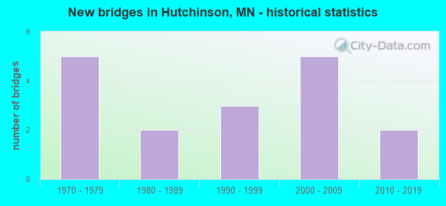
- New bridges - historical statistics
- 51970-1979
- 21980-1989
- 31990-1999
- 52000-2009
- 22010-2019


- Bridge Condition - Deck
- 28.6%Very good
- 50.0%Good
- 21.4%Satisfactory

- Bridge Condition - Superstructure
- 28.6%Very good
- 57.1%Good
- 7.1%Satisfactory
- 7.1%Fair

- Bridge Condition - Substructure
- 21.4%Very good
- 71.4%Good
- 7.1%Satisfactory

- Bridge Condition - Channel
- 30.8%Very good
- 53.8%Good
- 7.7%Satisfactory
- 7.7%Fair
Find on map >> Show street view
Structure Number: 43006, Location: 0.1 MI NE OF JCT TH 22 (Lat: 44.764356, Lng: -94.156372), Route carried "on" structure: , Year Built: 1971, Status: Open, Structure Length: 9.96m (32.68ft), Features Intersected: US 212, Facility Carried by Structure: PEDESTRIAN
Lanes under structure: 4, Owner: State Highway Agency, Material/Design: Steel continuous, Design/Construction: Stringer/Multi-beam, Number Of Spans In Main Unit: 4, Length of Maximum Span: 28.5m (93.5ft), Out-to-Out Width: 2.9m (9.5ft)
Condition: Deck: Good, Superstructure: Good, Substructure: Good, Channel: Satisfactory, Underclear: Better than present minimum criteria, Waterway Adequacy: Equal to present desirable criteria, Bridge Posting: Required (Relationship of Operating Rating to Maximum Legal Load: > 39.9% below), Designated Inspection Frequency: Every 24 months, Inspection Date: September 2021, Deck Structure Type: Concrete Cast-file-Place
Find on map >> Show street view
Structure Number: 43012, Location: 1.3 MI S OF JCT TH 7 (Lat: 44.877797, Lng: -94.359086), Route carried "on" structure: County highway 25, Year Built: 1989, Status: Open, Structure Length: 3.12m (10.24ft), Average Daily Traffic: 2,050 (year 2017), Average Future Daily Traffic: 2,050 (year 2039), Design Load: HS 25 or greater, Features Intersected: S FK CROW RIVER
Minimum Vertical Clearance: 30+ m (98+ ft), Kilometerpoint: 0.000, Lanes on structure: 4, Owner: County Highway Agency, Approaching Roadway Width: 15.9m (52.2ft), Material/Design: Concrete continuous, Design/Construction: Slab, Number Of Spans In Main Unit: 3, Length of Maximum Span: 10.1m (33.1ft), Curb-To-Curb Width: 18.3m (60.0ft), Out-to-Out Width: 19.3m (63.3ft)
Condition: Deck: Good, Superstructure: Good, Substructure: Good, Channel: Very good, Operating Rating: 72.2 metric tons, Method Used To Determine Operating Rating: Load Factor (LF), Inventory Rating: 43.3 metric tons, Method Used To Determine Inventory Rating: Load Factor (LF), Structural Evaluation: Better than present minimum criteria, Deck Geometry: Somewhat better than minimum adequacy, Waterway Adequacy: Equal to present desirable criteria, Approach Roadway Alignment: Equal to present desirable criteria, Designated Inspection Frequency: Every 24 months, Inspection Date: October 2021, Deck Structure Type: Concrete Cast-file-Place, Wearing Surface/Protective System: Wearing Surface: Monolithic Concrete, Deck Protection: Epoxy Coated Reinforcing
Find on map >> Show street view
Structure Number: 43016, Location: IN HUTCHINSON (Lat: 44.895514, Lng: -94.369314), Route carried "on" structure: State highway 15, Year Built: 2006, Status: Open, Structure Length: 5.73m (18.80ft), Average Daily Traffic: 11,100 (year 2019), Truck Traffic: 7%, Average Future Daily Traffic: 11,600 (year 2039), Design Load: HL 93, Features Intersected: S FK CROW RIVER
Minimum Vertical Clearance: 30+ m (98+ ft), Kilometerpoint: 0.000, Lanes on structure: 4, Base Highway Network: Yes, Owner: State Highway Agency, Approaching Roadway Width: 23.2m (76.1ft), Skew: 20 degrees, Material/Design: Prestressed concrete, Design/Construction: Stringer/Multi-beam, Number Of Spans In Main Unit: 3, Length of Maximum Span: 24.4m (80.1ft), Curb or Sidewalk Widths: Left: 2.4m (7.9ft), Right: 2.4m (7.9ft), Curb-To-Curb Width: 23.2m (76.1ft), Out-to-Out Width: 30.8m (101.0ft)
Condition: Deck: Very good, Superstructure: Very good, Substructure: Very good, Channel: Good, Operating Rating: 57.8 metric tons, Method Used To Determine Operating Rating: Load Factor (LF), Inventory Rating: 34.6 metric tons, Method Used To Determine Inventory Rating: Load Factor (LF), Structural Evaluation: Equal to present desirable criteria, Deck Geometry: Superior to present desirable criteria, Waterway Adequacy: Equal to present desirable criteria, Approach Roadway Alignment: Equal to present desirable criteria, Designated Inspection Frequency: Every 24 months, Inspection Date: September 2020, Deck Structure Type: Concrete Cast-file-Place, Wearing Surface/Protective System: Wearing Surface: Monolithic Concrete, Deck Protection: Epoxy Coated Reinforcing
Find on map >> Show street view
Structure Number: 43514, Location: 0.1 MI S OF JCT TH 7 (Lat: 44.891233, Lng: -94.394061), Route carried "on" structure: City street 117, Year Built: 1978, Status: Open, Structure Length: 12.34m (40.49ft), Average Daily Traffic: 9,300 (year 2017), Average Future Daily Traffic: 9,300 (year 2039), Design Load: HS 25 or greater, Features Intersected: SOUTH FORK CROW RIVER
Minimum Vertical Clearance: 30+ m (98+ ft), Kilometerpoint: 0.000, Lanes on structure: 2, Owner: City or Municipal Highway Agency, Approaching Roadway Width: 13.4m (44.0ft), Skew: 1 degrees, Material/Design: Prestressed concrete, Design/Construction: Stringer/Multi-beam, Number Of Spans In Main Unit: 4, Length of Maximum Span: 30.5m (100.1ft), Curb or Sidewalk Widths: Left: 1.9m (6.2ft), Right: 0.0m, Curb-To-Curb Width: 10.4m (34.1ft), Out-to-Out Width: 13.2m (43.3ft)
Condition: Deck: Satisfactory, Superstructure: Fair, Substructure: Satisfactory, Channel: Good, Operating Rating: 63.3 metric tons, Method Used To Determine Operating Rating: Load Factor (LF), Inventory Rating: 38.7 metric tons, Method Used To Determine Inventory Rating: Load Factor (LF), Structural Evaluation: Somewhat better than minimum adequacy, Deck Geometry: Meets minimum limits, Waterway Adequacy: Equal to present desirable criteria, Approach Roadway Alignment: Equal to present desirable criteria, Designated Inspection Frequency: Every 24 months, Underwater Inspection Frequency: Every 60 months, Inspection Date: September 2021, Underwater Inspection Date: August 2020, Deck Structure Type: Concrete Cast-file-Place, Wearing Surface/Protective System: Wearing Surface: Low Slump Concrete
Find on map >> Show street view
Structure Number: 43518, Location: 0.6 MI S OF JCT CSAH 14 (Lat: 44.884828, Lng: -94.457642), Route carried "on" structure: County highway 150, Year Built: 1979, Status: Open, Structure Length: 2.77m (9.09ft), Average Daily Traffic: 36 (year 1970), Average Future Daily Traffic: 36 (year 2029), Design Load: HS 20, Features Intersected: S FK CROW RIVER
Minimum Vertical Clearance: 30+ m (98+ ft), Kilometerpoint: 0.000, Lanes on structure: 2, Owner: Town or Township Highway Agency, Approaching Roadway Width: 8.5m (27.9ft), Skew: 2 degrees, Material/Design: Prestressed concrete, Design/Construction: Tee Beam, Number Of Spans In Main Unit: 1, Length of Maximum Span: 27.1m (88.9ft), Curb-To-Curb Width: 8.6m (28.2ft), Out-to-Out Width: 9.8m (32.2ft)
Condition: Deck: Good, Superstructure: Good, Substructure: Very good, Channel: Good, Operating Rating: 67.4 metric tons, Method Used To Determine Operating Rating: Load Factor (LF), Inventory Rating: 35.6 metric tons, Method Used To Determine Inventory Rating: Load Factor (LF), Structural Evaluation: Better than present minimum criteria, Deck Geometry: Better than present minimum criteria, Waterway Adequacy: Better than present minimum criteria, Approach Roadway Alignment: Better than present minimum criteria, Designated Inspection Frequency: Every 24 months, Inspection Date: October 2021, Deck Structure Type: Concrete Cast-file-Place, Wearing Surface/Protective System: Wearing Surface: Monolithic Concrete
Find on map >> Show street view
Structure Number: 43519, Location: 2.6 MI W OF JCT TH 7 (Lat: 44.892414, Lng: -94.478631), Route carried "on" structure: County highway 14, Year Built: 1982, Status: Open, Structure Length: 4.44m (14.57ft), Average Daily Traffic: 1,050 (year 2017), Average Future Daily Traffic: 1,050 (year 2039), Design Load: HS 20, Features Intersected: S FK CROW RIVER
Minimum Vertical Clearance: 30+ m (98+ ft), Kilometerpoint: 0.000, Lanes on structure: 2, Owner: County Highway Agency, Approaching Roadway Width: 12.2m (40.0ft), Material/Design: Steel continuous, Design/Construction: Stringer/Multi-beam, Number Of Spans In Main Unit: 3, Length of Maximum Span: 16.8m (55.1ft), Curb-To-Curb Width: 12.2m (40.0ft), Out-to-Out Width: 13.2m (43.3ft)
Condition: Deck: Good, Superstructure: Good, Substructure: Good, Channel: Good, Operating Rating: 55.1 metric tons, Method Used To Determine Operating Rating: Load Factor (LF), Inventory Rating: 33.0 metric tons, Method Used To Determine Inventory Rating: Load Factor (LF), Structural Evaluation: Better than present minimum criteria, Deck Geometry: Better than present minimum criteria, Waterway Adequacy: Superior to present desirable criteria, Approach Roadway Alignment: Equal to present desirable criteria, Designated Inspection Frequency: Every 24 months, Inspection Date: October 2021, Deck Structure Type: Concrete Cast-file-Place, Wearing Surface/Protective System: Wearing Surface: Monolithic Concrete
Find on map >> Show street view
Structure Number: 43528, Location: .08 MI W OF JCT TH 22 (Lat: 44.862775, Lng: -94.337075), Route carried "on" structure: County highway 115, Year Built: 1993, Status: Open, Structure Length: 6.83m (22.41ft), Average Daily Traffic: 4,700 (year 2017), Average Future Daily Traffic: 4,700 (year 2039), Design Load: HS 25 or greater, Features Intersected: SOUTH FORK CROW RIVER
Minimum Vertical Clearance: 30+ m (98+ ft), Kilometerpoint: 0.000, Lanes on structure: 2, Owner: County Highway Agency, Approaching Roadway Width: 13.4m (44.0ft), Skew: 2 degrees, Material/Design: Prestressed concrete, Design/Construction: Stringer/Multi-beam, Number Of Spans In Main Unit: 2, Length of Maximum Span: 33.1m (108.6ft), Curb-To-Curb Width: 13.4m (44.0ft), Out-to-Out Width: 14.4m (47.2ft)
Condition: Deck: Good, Superstructure: Good, Substructure: Good, Channel: Good, Operating Rating: 74.6 metric tons, Method Used To Determine Operating Rating: Load Factor (LF), Inventory Rating: 45.3 metric tons, Method Used To Determine Inventory Rating: Load Factor (LF), Structural Evaluation: Better than present minimum criteria, Deck Geometry: Better than present minimum criteria, Waterway Adequacy: Superior to present desirable criteria, Approach Roadway Alignment: Equal to present desirable criteria, Designated Inspection Frequency: Every 24 months, Inspection Date: October 2021, Deck Structure Type: Concrete Cast-file-Place, Wearing Surface/Protective System: Wearing Surface: Monolithic Concrete, Deck Protection: Epoxy Coated Reinforcing
Find on map >> Show street view
Structure Number: 43531, Location: 0.1 MI S OF JCT TH 7 (Lat: 44.893781, Lng: -94.364364), Route carried "on" structure: County highway 25, Year Built: 1996, Status: Open, Structure Length: 3.63m (11.91ft), Average Daily Traffic: 7,300 (year 2017), Average Future Daily Traffic: 7,300 (year 2039), Design Load: HS 25 or greater, Features Intersected: SOUTH FORK CROW RIVER
Minimum Vertical Clearance: 30+ m (98+ ft), Kilometerpoint: 0.000, Lanes on structure: 4, Owner: County Highway Agency, Approaching Roadway Width: 15.9m (52.2ft), Skew: 2 degrees, Material/Design: Concrete continuous, Design/Construction: Slab, Number Of Spans In Main Unit: 3, Length of Maximum Span: 13.5m (44.3ft), Curb or Sidewalk Widths: Left: 1.8m (5.9ft), Right: 1.8m (5.9ft), Curb-To-Curb Width: 15.9m (52.2ft), Out-to-Out Width: 20.6m (67.6ft)
Condition: Deck: Satisfactory, Superstructure: Satisfactory, Substructure: Good, Channel: Good, Operating Rating: 97.0 metric tons, Method Used To Determine Operating Rating: Load Factor (LF), Inventory Rating: 58.0 metric tons, Method Used To Determine Inventory Rating: Load Factor (LF), Structural Evaluation: Equal to present minimum criteria, Deck Geometry: Meets minimum limits, Waterway Adequacy: Better than present minimum criteria, Approach Roadway Alignment: Better than present minimum criteria, Designated Inspection Frequency: Every 24 months, Inspection Date: October 2021, Deck Structure Type: Concrete Cast-file-Place, Wearing Surface/Protective System: Wearing Surface: Low Slump Concrete, Deck Protection: Epoxy Coated Reinforcing
Find on map >> Show street view
Structure Number: 43532, Location: 0.7 M E OF JCT TH 15 (Lat: 44.886925, Lng: -94.356728), Route carried "on" structure: City street 108, Year Built: 1998, Status: Open, Structure Length: 13.88m (45.54ft), Average Daily Traffic: 3,850 (year 2017), Average Future Daily Traffic: 3,850 (year 2039), Design Load: HS 25 or greater, Features Intersected: S FK CROW RIVER
Minimum Vertical Clearance: 30+ m (98+ ft), Kilometerpoint: 0.000, Lanes on structure: 2, Owner: City or Municipal Highway Agency, Approaching Roadway Width: 13.1m (43.0ft), Material/Design: Prestressed concrete, Design/Construction: Stringer/Multi-beam, Number Of Spans In Main Unit: 4, Length of Maximum Span: 34.5m (113.2ft), Curb or Sidewalk Widths: Left: 0.0m, Right: 2.4m (7.9ft), Curb-To-Curb Width: 13.3m (43.6ft), Out-to-Out Width: 16.4m (53.8ft)
Condition: Deck: Satisfactory, Superstructure: Very good, Substructure: Good, Channel: Very good, Operating Rating: 75.3 metric tons, Method Used To Determine Operating Rating: Load Factor (LF), Inventory Rating: 35.6 metric tons, Method Used To Determine Inventory Rating: Load Factor (LF), Structural Evaluation: Better than present minimum criteria, Deck Geometry: Equal to present minimum criteria, Waterway Adequacy: Equal to present desirable criteria, Approach Roadway Alignment: Better than present minimum criteria, Designated Inspection Frequency: Every 24 months, Inspection Date: September 2021, Deck Structure Type: Concrete Cast-file-Place, Wearing Surface/Protective System: Wearing Surface: Low Slump Concrete, Deck Protection: Epoxy Coated Reinforcing
Find on map >> Show street view
Structure Number: 43539, Location: 0.7 MI E OF JCT TH 15 (Lat: 44.890083, Lng: -94.357064), Route carried "on" structure: City street 109, Year Built: 2018, Status: Open, Structure Length: 4.50m (14.76ft), Average Daily Traffic: 1,625 (year 2017), Average Future Daily Traffic: 2,113 (year 2037), Design Load: HL 93, Features Intersected: SOUTH FORK CROW RIVER
Minimum Vertical Clearance: 30+ m (98+ ft), Kilometerpoint: 0.000, Lanes on structure: 2, Owner: City or Municipal Highway Agency, Approaching Roadway Width: 13.0m (42.7ft), Skew: 1 degrees, Material/Design: Concrete continuous, Design/Construction: Slab, Number Of Spans In Main Unit: 3, Length of Maximum Span: 17.7m (58.1ft), Curb or Sidewalk Widths: Left: 0.0m, Right: 3.7m (12.1ft), Curb-To-Curb Width: 8.5m (27.9ft), Out-to-Out Width: 13.0m (42.7ft)
Condition: Deck: Very good, Superstructure: Very good, Substructure: Very good, Channel: Very good, Operating Rating: 62.5 metric tons, Method Used To Determine Operating Rating: Load and Resistance Factor Rating (LRFR) rating reported by rating factor(RF) method using HL-93 loadings, Inventory Rating: 48.3 metric tons, Method Used To Determine Inventory Rating: Load and Resistance Factor Rating (LRFR) rating reported by rating factor(RF) method using HL-93 loadings, Structural Evaluation: Equal to present desirable criteria, Deck Geometry: Somewhat better than minimum adequacy, Waterway Adequacy: Better than present minimum criteria, Approach Roadway Alignment: Equal to present desirable criteria, Designated Inspection Frequency: Every 24 months, Inspection Date: September 2021, Deck Structure Type: Concrete Cast-file-Place, Wearing Surface/Protective System: Wearing Surface: Monolithic Concrete, Deck Protection: Epoxy Coated Reinforcing
Find on map >> Show street view
Structure Number: 4354, Location: 0.25 mi S of TH 7 (Lat: 44.892514, Lng: -94.333244), Route carried "on" structure: , Year Built: 2002, Status: Open, Structure Length: 4.18m (13.71ft), Features Intersected: TH 22, Facility Carried by Structure: PEDESTRIAN
Lanes under structure: 4, Owner: State Park, Forest, or Reservation Agency, Material/Design: Prestressed concrete, Design/Construction: Stringer/Multi-beam, Number Of Spans In Main Unit: 1, Length of Maximum Span: 41.1m (134.8ft), Out-to-Out Width: 4.3m (14.1ft)
Condition: Deck: Very good, Superstructure: Good, Substructure: Good, Underclear: Equal to present desirable criteria, Bridge Posting: Required (Relationship of Operating Rating to Maximum Legal Load: > 39.9% below), Designated Inspection Frequency: Every 24 months, Inspection Date: September 2021, Deck Structure Type: Concrete Cast-file-Place, Wearing Surface/Protective System: Wearing Surface: Monolithic Concrete
Find on map >> Show street view
Structure Number: 43543, Location: 0.7 mi S of jct CSAH 14 (Lat: 44.882114, Lng: -94.436997), Route carried "on" structure: County highway 115, Year Built: 2002, Status: Open, Structure Length: 3.01m (9.88ft), Average Daily Traffic: 1,950 (year 2017), Average Future Daily Traffic: 1,950 (year 2039), Design Load: HS 25 or greater, Features Intersected: S Fk Crow River
Minimum Vertical Clearance: 30+ m (98+ ft), Kilometerpoint: 0.000, Lanes on structure: 2, Base Highway Network: Yes, Owner: County Highway Agency, Approaching Roadway Width: 12.2m (40.0ft), Skew: 2 degrees, Material/Design: Concrete continuous, Design/Construction: Slab, Number Of Spans In Main Unit: 3, Length of Maximum Span: 12.2m (40.0ft), Curb-To-Curb Width: 13.4m (44.0ft), Out-to-Out Width: 14.4m (47.2ft)
Condition: Deck: Good, Superstructure: Good, Substructure: Good, Channel: Good, Operating Rating: 91.6 metric tons, Method Used To Determine Operating Rating: Load Factor (LF), Inventory Rating: 55.1 metric tons, Method Used To Determine Inventory Rating: Load Factor (LF), Structural Evaluation: Better than present minimum criteria, Deck Geometry: Equal to present desirable criteria, Waterway Adequacy: Equal to present desirable criteria, Approach Roadway Alignment: Equal to present desirable criteria, Designated Inspection Frequency: Every 24 months, Inspection Date: October 2021, Deck Structure Type: Concrete Cast-file-Place, Wearing Surface/Protective System: Wearing Surface: Low Slump Concrete, Deck Protection: Epoxy Coated Reinforcing
Find on map >> Show street view
Structure Number: 43545, Location: 0.4 MI W OF JCT TH 22 (Lat: 44.848661, Lng: -94.322333), Route carried "on" structure: County highway 420, Year Built: 2003, Status: Open, Structure Length: 5.61m (18.41ft), Average Daily Traffic: 68 (year 2003), Average Future Daily Traffic: 68 (year 2029), Design Load: HS 25 or greater, Features Intersected: S FORK CROW RIVER
Minimum Vertical Clearance: 0.00m, Kilometerpoint: 0.000, Lanes on structure: 2, Owner: Town or Township Highway Agency, Approaching Roadway Width: 11.0m (36.1ft), Skew: 5 degrees, Material/Design: Prestressed concrete, Design/Construction: Stringer/Multi-beam, Number Of Spans In Main Unit: 2, Length of Maximum Span: 25.3m (83.0ft), Curb-To-Curb Width: 11.0m (36.1ft), Out-to-Out Width: 12.0m (39.4ft)
Condition: Deck: Very good, Superstructure: Very good, Substructure: Good, Channel: Fair, Operating Rating: 65.9 metric tons, Method Used To Determine Operating Rating: Load Factor (LF), Inventory Rating: 34.3 metric tons, Method Used To Determine Inventory Rating: Load Factor (LF), Structural Evaluation: Better than present minimum criteria, Deck Geometry: Superior to present desirable criteria, Waterway Adequacy: Equal to present desirable criteria, Approach Roadway Alignment: Equal to present desirable criteria, Designated Inspection Frequency: Every 24 months, Inspection Date: October 2021, Deck Structure Type: Concrete Cast-file-Place, Wearing Surface/Protective System: Wearing Surface: Monolithic Concrete, Deck Protection: Epoxy Coated Reinforcing
Find on map >> Show street view
Structure Number: 43559, Location: 1.3 MI W OF JCT CSAH 7 (Lat: 44.878106, Lng: -94.414847), Route carried "on" structure: City street 130, Year Built: 2018, Status: Open, Structure Length: 1.57m (5.15ft), Average Daily Traffic: 1,400 (year 2017), Average Future Daily Traffic: 1,400 (year 2039), Design Load: HL 93, Features Intersected: OTTER LAKE
Minimum Vertical Clearance: 30+ m (98+ ft), Kilometerpoint: 0.000, Lanes on structure: 2, Owner: City or Municipal Highway Agency, Approaching Roadway Width: 11.6m (38.1ft), Material/Design: Concrete, Design/Construction: Slab, Number Of Spans In Main Unit: 1, Length of Maximum Span: 15.7m (51.5ft), Curb or Sidewalk Widths: Left: 0.0m, Right: 3.7m (12.1ft), Curb-To-Curb Width: 11.6m (38.1ft), Out-to-Out Width: 16.2m (53.1ft)
Condition: Deck: Good, Superstructure: Good, Substructure: Good, Channel: Very good, Operating Rating: 49.9 metric tons, Method Used To Determine Operating Rating: Load and Resistance Factor Rating (LRFR) rating reported by rating factor(RF) method using HL-93 loadings, Inventory Rating: 38.6 metric tons, Method Used To Determine Inventory Rating: Load and Resistance Factor Rating (LRFR) rating reported by rating factor(RF) method using HL-93 loadings, Structural Evaluation: Better than present minimum criteria, Deck Geometry: Equal to present minimum criteria, Waterway Adequacy: Better than present minimum criteria, Approach Roadway Alignment: Equal to present desirable criteria, Designated Inspection Frequency: Every 24 months, Inspection Date: September 2021, Deck Structure Type: Concrete Cast-file-Place, Wearing Surface/Protective System: Wearing Surface: Monolithic Concrete, Deck Protection: Epoxy Coated Reinforcing
Find on map >> Show street view
Structure Number: 93332, Location: 0.1 MI S OF JCT TH 7 (Lat: 44.892781, Lng: -94.394875), Route carried "on" structure: City street 117, Year Built: 1978, Status: Open, Structure Length: 0.76m (2.49ft), Average Daily Traffic: 9,300 (year 2017), Average Future Daily Traffic: 9,300 (year 2039), Design Load: HS 20, Features Intersected: LUCE LINE TRAIL
Minimum Vertical Clearance: 30+ m (98+ ft), Kilometerpoint: 0.000, Lanes on structure: 2, Owner: City or Municipal Highway Agency, Approaching Roadway Width: 13.4m (44.0ft), Material/Design: Concrete, Design/Construction: Culvert, Number Of Spans In Main Unit: 2, Length of Maximum Span: 3.0m (9.8ft)
Condition: Culverts: Satisfactory, Operating Rating: 49.0 metric tons, Method Used To Determine Operating Rating: Assigned rating based on Load Factor Design (LFD) reported in metric tons, Inventory Rating: 32.7 metric tons, Method Used To Determine Inventory Rating: Assigned rating based on Load Factor Design (LFD) reported in metric tons, Structural Evaluation: Equal to present minimum criteria, Approach Roadway Alignment: Better than present minimum criteria, Designated Inspection Frequency: Every 48 months, Inspection Date: September 2021
Find on map >> Show street view
Structure Number: 43006, Location: 0.1 MI NE OF JCT TH 22 (Lat: 44.764356, Lng: -94.156372), Route carried "under" structure: US 212, Year Built: 1971, Structure Length: 0. m, Average Daily Traffic: 7,300 (year 2019), Truck Traffic: 18%, Features Intersected: US 212, Facility Carried by Structure: PEDESTRIAN
Minimum Vertical Clearance: 5.33m (17.49ft), Kilometerpoint: 0.000, Lanes on structure: 4, Lanes under structure: 4, Material/Design: Steel continuous, Design/Construction: Stringer/Multi-beam, Length of Maximum Span: 28.5m (93.5ft)
Find on map >> Show street view
Structure Number: 4354, Location: 0.25 mi S of TH 7 (Lat: 44.892514, Lng: -94.333244), Route carried "under" structure: State highway 22, Year Built: 2002, Structure Length: 0. m, Average Daily Traffic: 3,350 (year 2019), Truck Traffic: 11%, Features Intersected: TH 22, Facility Carried by Structure: PEDESTRIAN
Minimum Vertical Clearance: 5.24m (17.19ft), Kilometerpoint: 0.000, Lanes on structure: 4, Lanes under structure: 4, Material/Design: Prestressed concrete, Design/Construction: Stringer/Multi-beam, Length of Maximum Span: 41.1m (134.8ft)