Bridge Statistics for Jefferson, Virginia (VA)
Condition, Traffic, Stress, Structural Evaluation, Project Costs
- National Bridge Inventory (NBI) Statistics
- 21Number of bridges
- 85ft / 25.6mTotal length
- $2,648,000Total costs
- 517,401Total average daily traffic
- 9,445Total average daily truck traffic
- National Bridge Inventory (NBI) Registered Bridges for Jefferson
- No street view available for this location
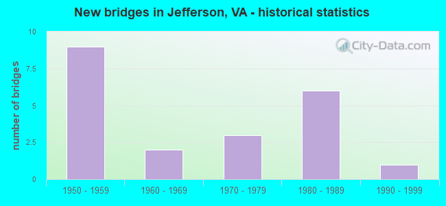
- New bridges - historical statistics
- 91950-1959
- 21960-1969
- 31970-1979
- 61980-1989
- 11990-1999

- Reconstructed bridges - Historical Statistics
- 31990-1999
- 12000-2009


- Bridge Condition - Deck
- 87.5%Good
- 12.5%Satisfactory

- Bridge Condition - Superstructure
- 37.5%Good
- 62.5%Satisfactory

- Bridge Condition - Substructure
- 37.5%Good
- 50.0%Satisfactory
- 12.5%Fair

- Bridge Condition - Channel
- 22.2%Very good
- 22.2%Good
- 55.6%Satisfactory

- Bridge Condition - Culverts
- 40.0%Good
- 60.0%Satisfactory
Find on map >> Show street view
Structure Number: 6174, Location: 00.00FRF712/00.00TO0000 (Lat: 38.872322, Lng: -77.157428), Route carried "on" structure: Other road , Year Built: 1958, Year Reconstructed: 1999, Status: Open, Structure Length: 2.23m (7.32ft), Average Daily Traffic: 3,932 (year 2014), Average Future Daily Traffic: 5,171 (year 2035), Design Load: HS 20, Features Intersected: ARLINGTON BOULEVARD, Facility Carried by Structure: CONNECTOR ROAD
Minimum Vertical Clearance: 30+ m (98+ ft), Kilometerpoint: 0.000, Lanes on structure: 2, Lanes under structure: 4, Owner: State Highway Agency, Approaching Roadway Width: 7.3m (24.0ft), Material/Design: Steel, Design/Construction: Stringer/Multi-beam, Number Of Spans In Main Unit: 1, Length of Maximum Span: 22.3m (73.2ft), Curb or Sidewalk Widths: Left: 1.5m (4.9ft), Right: 0.0m, Curb-To-Curb Width: 7.6m (24.9ft), Out-to-Out Width: 10.1m (33.1ft)
Condition: Deck: Good, Superstructure: Good, Substructure: Satisfactory, Operating Rating: 39.5 metric tons, Method Used To Determine Operating Rating: Load and Resistance Factor (LRFR), Inventory Rating: 30.5 metric tons, Method Used To Determine Inventory Rating: Load and Resistance Factor (LRFR), Structural Evaluation: Equal to present minimum criteria, Deck Geometry: High priority of replacement, Underclear: Meets minimum limits, Approach Roadway Alignment: Equal to present desirable criteria, Length Of Structure Improvement: 2.23m (7.32ft), Designated Inspection Frequency: Every 24 months, Inspection Date: October 2021, Bridge Improvement Cost: $500,000, Roadway Improvement Cost: $50,000, Total Project Cost: $560,000, Deck Structure Type: Concrete Cast-file-Place, Wearing Surface/Protective System: Deck Protection: Epoxy Coated Reinforcing
Find on map >> Show street view
Structure Number: 6236, Location: 01.42FR714/01.10TO29 (Lat: 38.872472, Lng: -77.156442), Route carried "on" structure: State highway 7, Year Built: 1958, Year Reconstructed: 1999, Status: Open, Structure Length: 4.21m (13.81ft), Average Daily Traffic: 8,804 (year 2020), Truck Traffic: 3%, Average Future Daily Traffic: 9,686 (year 2040), Design Load: HS 20, Features Intersected: ARLINGTON BLVD. (RTE.50), Facility Carried by Structure: LEESBURG PIKE EB
Minimum Vertical Clearance: 30+ m (98+ ft), Kilometerpoint: 104.698, Lanes on structure: 4, Lanes under structure: 4, Base Highway Network: Yes, Owner: State Highway Agency, Approaching Roadway Width: 12.2m (40.0ft), Skew: 5 degrees, Material/Design: Steel, Design/Construction: Stringer/Multi-beam, Number Of Spans In Main Unit: 1, Length of Maximum Span: 42.1m (138.1ft), Curb or Sidewalk Widths: Left: 0.0m, Right: 1.5m (4.9ft), Curb-To-Curb Width: 12.7m (41.7ft), Out-to-Out Width: 15.2m (49.9ft)
Condition: Deck: Good, Superstructure: Satisfactory, Substructure: Satisfactory, Operating Rating: 40.6 metric tons, Method Used To Determine Operating Rating: Load and Resistance Factor (LRFR), Inventory Rating: 31.3 metric tons, Method Used To Determine Inventory Rating: Load and Resistance Factor (LRFR), Structural Evaluation: Equal to present minimum criteria, Deck Geometry: High priority of replacement, Underclear: Meets minimum limits, Approach Roadway Alignment: Equal to present desirable criteria, Length Of Structure Improvement: 4.21m (13.81ft), Designated Inspection Frequency: Every 24 months, Inspection Date: October 2021, Bridge Improvement Cost: $500,000, Roadway Improvement Cost: $50,000, Total Project Cost: $600,000, Deck Structure Type: Concrete Precast Panels, Wearing Surface/Protective System: Wearing Surface: Bituminous, Membrane: Epoxy, Deck Protection: Epoxy Coated Reinforcing
Find on map >> Show street view
Structure Number: 6238, Location: 01.42FR714/01.10TO29 (Lat: 38.872364, Lng: -77.155867), Route carried "on" structure: State highway 7, Year Built: 1958, Year Reconstructed: 1999, Status: Open, Structure Length: 3.35m (10.99ft), Average Daily Traffic: 17,035 (year 2020), Truck Traffic: 3%, Average Future Daily Traffic: 19,992 (year 2040), Design Load: HS 20, Features Intersected: ARLINGTON BOULEVARD, Facility Carried by Structure: LEESBURG PIKE WBL
Minimum Vertical Clearance: 30+ m (98+ ft), Kilometerpoint: 104.714, Lanes on structure: 3, Lanes under structure: 4, Base Highway Network: Yes, Owner: State Highway Agency, Approaching Roadway Width: 11.0m (36.1ft), Skew: 4 degrees, Material/Design: Steel, Design/Construction: Stringer/Multi-beam, Number Of Spans In Main Unit: 1, Length of Maximum Span: 33.5m (109.9ft), Curb or Sidewalk Widths: Left: 0.0m, Right: 1.5m (4.9ft), Curb-To-Curb Width: 12.2m (40.0ft), Out-to-Out Width: 14.8m (48.6ft)
Condition: Deck: Good, Superstructure: Satisfactory, Substructure: Satisfactory, Operating Rating: 57.0 metric tons, Method Used To Determine Operating Rating: Load and Resistance Factor (LRFR), Inventory Rating: 43.9 metric tons, Method Used To Determine Inventory Rating: Load and Resistance Factor (LRFR), Structural Evaluation: Equal to present minimum criteria, Deck Geometry: Meets minimum limits, Underclear: Meets minimum limits, Approach Roadway Alignment: Equal to present desirable criteria, Length Of Structure Improvement: 3.35m (10.99ft), Designated Inspection Frequency: Every 24 months, Inspection Date: October 2021, Bridge Improvement Cost: $400,000, Roadway Improvement Cost: $40,000, Total Project Cost: $500,000, Deck Structure Type: Concrete Precast Panels, Wearing Surface/Protective System: Wearing Surface: Bituminous, Membrane: Epoxy, Deck Protection: Epoxy Coated Reinforcing
Find on map >> Show street view
Structure Number: 6282, Location: 00.20FR6928/00.20TO704 (Lat: 38.874967, Lng: -77.211744), Route carried "on" structure: US 29, Year Built: 1976, Status: Open, Structure Length: 1.34m (4.40ft), Average Daily Traffic: 33,621 (year 2020), Truck Traffic: 4%, Average Future Daily Traffic: 36,983 (year 2040), Design Load: HS 20, Features Intersected: BRANCH OF HOLMES RUN, Facility Carried by Structure: LEE HIGHWAY
Minimum Vertical Clearance: 30+ m (98+ ft), Kilometerpoint: 385.919, Lanes on structure: 4, Base Highway Network: Yes, Owner: State Highway Agency, Approaching Roadway Width: 15.8m (51.8ft), Skew: 3 degrees, Material/Design: Concrete, Design/Construction: Culvert, Number Of Spans In Main Unit: 4, Length of Maximum Span: 3.4m (11.2ft)
Condition: Channel: Satisfactory, Culverts: Satisfactory, Operating Rating: 63.5 metric tons, Method Used To Determine Operating Rating: Load Factor (LF), Inventory Rating: 38.1 metric tons, Method Used To Determine Inventory Rating: Load Factor (LF), Structural Evaluation: Equal to present minimum criteria, Waterway Adequacy: Better than present minimum criteria, Approach Roadway Alignment: Better than present minimum criteria, Length Of Structure Improvement: 3.05m (10.01ft), Designated Inspection Frequency: Every 24 months, Inspection Date: October 2020, Bridge Improvement Cost: $1,000, Roadway Improvement Cost: $1,000, Total Project Cost: $3,000
Find on map >> Show street view
Structure Number: 6305, Location: 00.15FR649 0.08TO1713 (Lat: 38.869142, Lng: -77.177453), Route carried "on" structure: US 50, Year Built: 1970, Status: Open, Structure Length: 1.28m (4.20ft), Average Daily Traffic: 40,895 (year 2020), Truck Traffic: 1%, Average Future Daily Traffic: 43,461 (year 2040), Design Load: HS 20, Features Intersected: TRIPPS RUN, Facility Carried by Structure: ARLINGTON BLVD.
Minimum Vertical Clearance: 30+ m (98+ ft), Kilometerpoint: 126.693, Lanes on structure: 8, Base Highway Network: Yes, Owner: State Highway Agency, Approaching Roadway Width: 9.8m (32.2ft), Material/Design: Concrete, Design/Construction: Culvert, Number Of Spans In Main Unit: 4, Length of Maximum Span: 3.0m (9.8ft)
Condition: Channel: Satisfactory, Culverts: Satisfactory, Operating Rating: 73.5 metric tons, Method Used To Determine Operating Rating: Load Factor (LF), Inventory Rating: 43.5 metric tons, Method Used To Determine Inventory Rating: Load Factor (LF), Structural Evaluation: Equal to present minimum criteria, Waterway Adequacy: Better than present minimum criteria, Approach Roadway Alignment: Equal to present desirable criteria, Length Of Structure Improvement: 6.86m (22.51ft), Designated Inspection Frequency: Every 24 months, Inspection Date: June 2020, Bridge Improvement Cost: $44,000, Roadway Improvement Cost: $99,000, Total Project Cost: $150,000
Find on map >> Show street view
Structure Number: 6306, Location: 0.05FR FAIRVIEW 0.10TO50 (Lat: 38.866267, Lng: -77.215197), Route carried "on" structure: Ramp County highway 6928, Year Built: 1985, Status: Open, Structure Length: 2.59m (8.50ft), Average Daily Traffic: 9,000 (year 1988), Truck Traffic: 1%, Average Future Daily Traffic: 20,545 (year 2040), Design Load: HS 20, Features Intersected: RAMP G OF I - 495
Minimum Vertical Clearance: 30+ m (98+ ft), Kilometerpoint: 6.967, Lanes on structure: 2, Lanes under structure: 1, Base Highway Network: Yes, Owner: State Highway Agency, Approaching Roadway Width: 12.8m (42.0ft), Skew: 5 degrees, Material/Design: Steel, Design/Construction: Stringer/Multi-beam, Number Of Spans In Main Unit: 1, Length of Maximum Span: 25.9m (85.0ft), Curb or Sidewalk Widths: Left: 0.2m (0.7ft), Right: 0.2m (0.7ft), Curb-To-Curb Width: 12.2m (40.0ft), Out-to-Out Width: 13.4m (44.0ft)
Condition: Deck: Satisfactory, Superstructure: Satisfactory, Substructure: Satisfactory, Operating Rating: 62.0 metric tons, Method Used To Determine Operating Rating: Load and Resistance Factor (LRFR), Inventory Rating: 47.8 metric tons, Method Used To Determine Inventory Rating: Load and Resistance Factor (LRFR), Structural Evaluation: Equal to present minimum criteria, Deck Geometry: Superior to present desirable criteria, Underclear: Equal to present minimum criteria, Approach Roadway Alignment: Equal to present desirable criteria, Length Of Structure Improvement: 0.30m (0.98ft), Designated Inspection Frequency: Every 24 months, Inspection Date: January 2022, Bridge Improvement Cost: $55,000, Roadway Improvement Cost: $75,000, Total Project Cost: $150,000 ( Estimate for 2014), Deck Structure Type: Concrete Cast-file-Place, Wearing Surface/Protective System: Deck Protection: Epoxy Coated Reinforcing
Find on map >> Show street view
Structure Number: 6688, Location: 00.10FR1731/00.10TO872 (Lat: 38.860197, Lng: -77.166075), Route carried "on" structure: County highway 613, Year Built: 1968, Year Reconstructed: 2012, Status: Open, Structure Length: 2.90m (9.51ft), Average Daily Traffic: 9,703 (year 2020), Truck Traffic: 1%, Average Future Daily Traffic: 13,584 (year 2040), Design Load: HS 20, Features Intersected: TRIPPS RUN, Facility Carried by Structure: SLEEPY HOLLOW ROAD
Minimum Vertical Clearance: 30+ m (98+ ft), Kilometerpoint: 18.568, Lanes on structure: 2, Owner: State Highway Agency, Approaching Roadway Width: 13.4m (44.0ft), Skew: 1 degrees, Material/Design: Steel, Design/Construction: Stringer/Multi-beam, Number Of Spans In Main Unit: 1, Length of Maximum Span: 28.3m (92.8ft), Curb or Sidewalk Widths: Left: 1.5m (4.9ft), Right: 1.5m (4.9ft), Curb-To-Curb Width: 13.4m (44.0ft), Out-to-Out Width: 17.1m (56.1ft)
Condition: Deck: Good, Superstructure: Satisfactory, Substructure: Good, Channel: Satisfactory, Operating Rating: 49.0 metric tons, Method Used To Determine Operating Rating: Load and Resistance Factor (LRFR), Inventory Rating: 38.1 metric tons, Method Used To Determine Inventory Rating: Load and Resistance Factor (LRFR), Structural Evaluation: Equal to present minimum criteria, Deck Geometry: Equal to present minimum criteria, Waterway Adequacy: Better than present minimum criteria, Approach Roadway Alignment: Equal to present desirable criteria, Length Of Structure Improvement: 2.90m (9.51ft), Designated Inspection Frequency: Every 24 months, Inspection Date: May 2020, Bridge Improvement Cost: $50,000, Roadway Improvement Cost: $5,000, Total Project Cost: $60,000 ( Estimate for 2014), Deck Structure Type: Concrete Cast-file-Place, Wearing Surface/Protective System: Wearing Surface: Monolithic Concrete
Find on map >> Show street view
Structure Number: 6779, Location: 00.50FR708/00.21TO50 (Lat: 38.866686, Lng: -77.174808), Route carried "on" structure: County highway 649, Year Built: 1966, Status: Open, Structure Length: 1.71m (5.61ft), Average Daily Traffic: 12,401 (year 2020), Truck Traffic: 2%, Average Future Daily Traffic: 17,361 (year 2040), Design Load: HS 20, Features Intersected: TRIPPS RUN, Facility Carried by Structure: ANNANDALE ROAD
Minimum Vertical Clearance: 30+ m (98+ ft), Kilometerpoint: 5.390, Lanes on structure: 4, Owner: State Highway Agency, Approaching Roadway Width: 15.2m (49.9ft), Skew: 1 degrees, Material/Design: Steel, Design/Construction: Stringer/Multi-beam, Number Of Spans In Main Unit: 1, Length of Maximum Span: 17.1m (56.1ft), Curb or Sidewalk Widths: Left: 1.5m (4.9ft), Right: 1.5m (4.9ft), Curb-To-Curb Width: 14.6m (47.9ft), Out-to-Out Width: 18.3m (60.0ft)
Condition: Deck: Good, Superstructure: Satisfactory, Substructure: Fair, Channel: Satisfactory, Operating Rating: 94.3 metric tons, Method Used To Determine Operating Rating: Load and Resistance Factor (LRFR), Inventory Rating: 72.6 metric tons, Method Used To Determine Inventory Rating: Load and Resistance Factor (LRFR), Structural Evaluation: Somewhat better than minimum adequacy, Deck Geometry: High priority of replacement, Waterway Adequacy: Better than present minimum criteria, Approach Roadway Alignment: Better than present minimum criteria, Length Of Structure Improvement: 1.71m (5.61ft), Designated Inspection Frequency: Every 24 months, Inspection Date: April 2020, Bridge Improvement Cost: $157,000, Roadway Improvement Cost: $16,000, Total Project Cost: $200,000 ( Estimate for 2014), Deck Structure Type: Concrete Cast-file-Place, Wearing Surface/Protective System: Wearing Surface: Monolithic Concrete
Find on map >> Show street view
Structure Number: 6944, Location: 00.05FR1760/00.05TO1757 (Lat: 38.871014, Lng: -77.178067), Route carried "on" structure: County highway 1723, Year Built: 1971, Status: Open, Structure Length: 2.16m (7.09ft), Average Daily Traffic: 804 (year 2016), Average Future Daily Traffic: 900 (year 2040), Design Load: HS 20, Features Intersected: TRIPPS RUN, Facility Carried by Structure: JEFFERSON AVENUE
Minimum Vertical Clearance: 30+ m (98+ ft), Kilometerpoint: 1.089, Lanes on structure: 2, Owner: State Highway Agency, Approaching Roadway Width: 11.0m (36.1ft), Skew: 1 degrees, Material/Design: Steel, Design/Construction: Stringer/Multi-beam, Number Of Spans In Main Unit: 1, Length of Maximum Span: 21.0m (68.9ft), Curb-To-Curb Width: 11.0m (36.1ft), Out-to-Out Width: 11.8m (38.7ft)
Condition: Deck: Good, Superstructure: Good, Substructure: Good, Channel: Very good, Operating Rating: 89.8 metric tons, Method Used To Determine Operating Rating: Load and Resistance Factor (LRFR), Inventory Rating: 72.7 metric tons, Method Used To Determine Inventory Rating: Load and Resistance Factor (LRFR), Structural Evaluation: Better than present minimum criteria, Deck Geometry: Better than present minimum criteria, Waterway Adequacy: Better than present minimum criteria, Approach Roadway Alignment: Equal to present desirable criteria, Length Of Structure Improvement: 2.16m (7.09ft), Designated Inspection Frequency: Every 24 months, Inspection Date: Febuary 2022, Bridge Improvement Cost: $51,000, Roadway Improvement Cost: $85,000, Total Project Cost: $150,000, Deck Structure Type: Concrete Cast-file-Place, Wearing Surface/Protective System: Wearing Surface: Monolithic Concrete
Find on map >> Show street view
Structure Number: 7081, Location: 00.20FR29/00.60TO50 (Lat: 38.872472, Lng: -77.216800), Route carried "on" structure: County highway 6928, Year Built: 1987, Status: Open, Structure Length: 1.04m (3.41ft), Average Daily Traffic: 12,570 (year 2020), Truck Traffic: 4%, Average Future Daily Traffic: 17,598 (year 2040), Design Load: HS 20, Features Intersected: BRANCH OF HOLMES RUN, Facility Carried by Structure: Fairview Park Dr
Minimum Vertical Clearance: 30+ m (98+ ft), Kilometerpoint: 0.322, Lanes on structure: 6, Owner: State Highway Agency, Approaching Roadway Width: 8.2m (26.9ft), Material/Design: Concrete, Design/Construction: Culvert, Number Of Spans In Main Unit: 3, Length of Maximum Span: 3.0m (9.8ft)
Condition: Channel: Very good, Culverts: Good, Operating Rating: 68.0 metric tons, Method Used To Determine Operating Rating: Load Factor (LF), Inventory Rating: 40.8 metric tons, Method Used To Determine Inventory Rating: Load Factor (LF), Structural Evaluation: Better than present minimum criteria, Waterway Adequacy: Equal to present minimum criteria, Approach Roadway Alignment: Equal to present desirable criteria, Length Of Structure Improvement: 54.30m (178.15ft), Designated Inspection Frequency: Every 24 months, Inspection Date: Febuary 2021, Bridge Improvement Cost: $35,000, Roadway Improvement Cost: $55,000, Total Project Cost: $100,000 ( Estimate for 2015)
Find on map >> Show street view
Structure Number: 7082, Location: 00.10FR6928/00.21TO END (Lat: 38.873389, Lng: -77.213497), Route carried "on" structure: County highway 6929, Year Built: 1985, Status: Open, Structure Length: 0.77m (2.53ft), Average Daily Traffic: 1,462 (year 2019), Average Future Daily Traffic: 1,616 (year 2040), Design Load: HS 20, Features Intersected: BRANCH HOLMES RUN, Facility Carried by Structure: NEW PROVIDENCE DR.
Minimum Vertical Clearance: 30+ m (98+ ft), Kilometerpoint: 0.331, Lanes on structure: 2, Owner: State Highway Agency, Approaching Roadway Width: 11.6m (38.1ft), Skew: 1 degrees, Material/Design: Concrete, Design/Construction: Culvert, Number Of Spans In Main Unit: 3, Length of Maximum Span: 2.4m (7.9ft)
Condition: Channel: Satisfactory, Culverts: Good, Operating Rating: 64.4 metric tons, Method Used To Determine Operating Rating: Load Factor (LF), Inventory Rating: 38.1 metric tons, Method Used To Determine Inventory Rating: Load Factor (LF), Structural Evaluation: Better than present minimum criteria, Waterway Adequacy: Equal to present desirable criteria, Approach Roadway Alignment: Equal to present desirable criteria, Length Of Structure Improvement: 5.70m (18.70ft), Designated Inspection Frequency: Every 24 months, Inspection Date: July 2020, Bridge Improvement Cost: $27,000, Roadway Improvement Cost: $82,000, Total Project Cost: $130,000
Find on map >> Show street view
Structure Number: 25654, Location: 00.20FR1839/00.01TO2310 (Lat: 38.863456, Lng: -77.171581), Route carried "on" structure: County highway 1840, Year Built: 1999, Status: Open, Structure Length: 1.34m (4.40ft), Average Daily Traffic: 261 (year 2016), Average Future Daily Traffic: 323 (year 2040), Design Load: HS 20+Mod, Features Intersected: TRIPPS RUN, Facility Carried by Structure: HOLLOWAY ROAD
Minimum Vertical Clearance: 30+ m (98+ ft), Kilometerpoint: 0.257, Lanes on structure: 2, Owner: State Highway Agency, Approaching Roadway Width: 6.7m (22.0ft), Material/Design: Prestressed concrete, Design/Construction: Slab, Number Of Spans In Main Unit: 1, Length of Maximum Span: 12.2m (40.0ft), Curb or Sidewalk Widths: Left: 1.5m (4.9ft), Right: 1.5m (4.9ft), Curb-To-Curb Width: 6.8m (22.3ft), Out-to-Out Width: 10.7m (35.1ft)
Condition: Deck: Good, Superstructure: Good, Substructure: Good, Channel: Good, Operating Rating: 67.1 metric tons, Method Used To Determine Operating Rating: Load and Resistance Factor (LRFR), Inventory Rating: 51.7 metric tons, Method Used To Determine Inventory Rating: Load and Resistance Factor (LRFR), Structural Evaluation: Better than present minimum criteria, Deck Geometry: Meets minimum limits, Waterway Adequacy: Equal to present desirable criteria, Approach Roadway Alignment: Equal to present desirable criteria, Length Of Structure Improvement: 0.61m (2.00ft), Designated Inspection Frequency: Every 24 months, Inspection Date: March 2021, Bridge Improvement Cost: $20,000, Roadway Improvement Cost: $20,000, Total Project Cost: $42,000 ( Estimate for 2015), Deck Structure Type: Concrete Precast Panels, Wearing Surface/Protective System: Wearing Surface: Bituminous, Membrane: Epoxy, Deck Protection: Epoxy Coated Reinforcing
Find on map >> Show street view
Structure Number: 30147, Location: 1.10 fr 705 0.20 to 338 (Lat: 38.879281, Lng: -77.178250), Route carried "on" structure: City street 29, Year Built: 1980, Status: Open, Structure Length: 0.70m (2.30ft), Average Daily Traffic: 21,780 (year 2020), Truck Traffic: 4%, Average Future Daily Traffic: 23,958 (year 2040), Design Load: HS 20, Features Intersected: Tripps Run
Minimum Vertical Clearance: 30+ m (98+ ft), Kilometerpoint: 0.000, Lanes on structure: 4, Owner: State Highway Agency, Approaching Roadway Width: 26.8m (87.9ft), Skew: 2 degrees, Material/Design: Concrete, Design/Construction: Culvert, Number Of Spans In Main Unit: 2, Length of Maximum Span: 3.0m (9.8ft)
Condition: Channel: Good, Culverts: Satisfactory, Operating Rating: 69.9 metric tons, Method Used To Determine Operating Rating: Load Factor (LF), Inventory Rating: 41.7 metric tons, Method Used To Determine Inventory Rating: Load Factor (LF), Structural Evaluation: Equal to present minimum criteria, Waterway Adequacy: Superior to present desirable criteria, Approach Roadway Alignment: Equal to present minimum criteria, Length Of Structure Improvement: 0.30m (0.98ft), Designated Inspection Frequency: Every 24 months, Inspection Date: January 2022, Bridge Improvement Cost: $1,000, Roadway Improvement Cost: $1,000, Total Project Cost: $3,000 ( Estimate for 2014)
Find on map >> Show street view
Structure Number: 6174, Location: 00.00FRF712/00.00TO0000 (Lat: 38.872322, Lng: -77.157428), Route carried "under" structure: US 50, Year Built: 1958, Structure Length: 0. m, Average Daily Traffic: 55,877 (year 2008), Truck Traffic: 1%, Features Intersected: ARLINGTON BOULEVARD, Facility Carried by Structure: CONNECTOR ROAD
Minimum Vertical Clearance: 4.47m (14.67ft), Kilometerpoint: 128.511, Lanes on structure: 2, Lanes under structure: 2, Material/Design: Steel, Design/Construction: Stringer/Multi-beam, Length of Maximum Span: 22.3m (73.2ft)
Find on map >> Show street view
Structure Number: 6174, Location: 00.00FRF712/00.00TO0000 (Lat: 38.872322, Lng: -77.157428), Route carried "under" structure: US 50, Year Built: 1958, Structure Length: 0. m, Average Daily Traffic: 53,492 (year 1997), Truck Traffic: 2%, Features Intersected: ARLINGTON BOULEVARD, Facility Carried by Structure: CONNECTOR ROAD
Minimum Vertical Clearance: 4.44m (14.57ft), Kilometerpoint: 128.511, Lanes on structure: 2, Lanes under structure: 2, Material/Design: Steel, Design/Construction: Stringer/Multi-beam, Length of Maximum Span: 22.3m (73.2ft)
Find on map >> Show street view
Structure Number: 6236, Location: 01.42FR714/01.10TO29 (Lat: 38.872472, Lng: -77.156442), Route carried "under" structure: US 50, Year Built: 1958, Structure Length: 0. m, Average Daily Traffic: 55,877 (year 2008), Truck Traffic: 2%, Features Intersected: ARLINGTON BLVD. (RTE.50), Facility Carried by Structure: LEESBURG PIKE EB
Minimum Vertical Clearance: 4.86m (15.94ft), Kilometerpoint: 128.575, Lanes on structure: 4, Lanes under structure: 2, Material/Design: Steel, Design/Construction: Stringer/Multi-beam, Length of Maximum Span: 42.1m (138.1ft)
Find on map >> Show street view
Structure Number: 6236, Location: 01.42FR714/01.10TO29 (Lat: 38.872472, Lng: -77.156442), Route carried "under" structure: US 50, Year Built: 1958, Structure Length: 0. m, Average Daily Traffic: 55,877 (year 2008), Truck Traffic: 2%, Features Intersected: ARLINGTON BLVD. (RTE.50), Facility Carried by Structure: LEESBURG PIKE EB
Minimum Vertical Clearance: 4.54m (14.90ft), Kilometerpoint: 128.575, Lanes on structure: 4, Lanes under structure: 2, Material/Design: Steel, Design/Construction: Stringer/Multi-beam, Length of Maximum Span: 42.1m (138.1ft)
Find on map >> Show street view
Structure Number: 6238, Location: 01.42FR714/01.10TO29 (Lat: 38.872364, Lng: -77.155867), Route carried "under" structure: US 50, Year Built: 1958, Structure Length: 0. m, Average Daily Traffic: 55,877 (year 2008), Truck Traffic: 1%, Features Intersected: ARLINGTON BOULEVARD, Facility Carried by Structure: LEESBURG PIKE WBL
Minimum Vertical Clearance: 4.85m (15.91ft), Kilometerpoint: 128.623, Lanes on structure: 3, Lanes under structure: 2, Material/Design: Steel, Design/Construction: Stringer/Multi-beam, Length of Maximum Span: 33.5m (109.9ft)
Find on map >> Show street view
Structure Number: 6238, Location: 01.42FR714/01.10TO29 (Lat: 38.872364, Lng: -77.155867), Route carried "under" structure: US 50, Year Built: 1958, Structure Length: 0. m, Average Daily Traffic: 47,133 (year 1994), Truck Traffic: 1%, Features Intersected: ARLINGTON BOULEVARD, Facility Carried by Structure: LEESBURG PIKE WBL
Minimum Vertical Clearance: 5.18m (16.99ft), Kilometerpoint: 128.623, Lanes on structure: 3, Lanes under structure: 2, Material/Design: Steel, Design/Construction: Stringer/Multi-beam, Length of Maximum Span: 33.5m (109.9ft)
Find on map >> Show street view
Structure Number: 6306, Location: 0.05FR FAIRVIEW 0.10TO50 (Lat: 38.866267, Lng: -77.215197), Route carried "under" structure: Ramp County highway 6928, Year Built: 1985, Structure Length: 0. m, Average Daily Traffic: 11,000 (year 1994), Truck Traffic: 2%, Features Intersected: RAMP G OF I - 495
Minimum Vertical Clearance: 4.52m (14.83ft), Kilometerpoint: 0.000, Lanes on structure: 2, Lanes under structure: 1, Material/Design: Steel, Design/Construction: Stringer/Multi-beam, Length of Maximum Span: 25.9m (85.0ft)
Find on map >> Show street view
Structure Number: 6636, Location: 00.10FR495NB/00.05TO50WB (Lat: 38.866794, Lng: -77.218081), Route carried "under" structure: Ramp State highway 50, Year Built: 1985, Structure Length: 0. m, Average Daily Traffic: 10,000 (year 1992), Features Intersected: RAMP L & M, Facility Carried by Structure: RAMP N OF RTE.495
Minimum Vertical Clearance: 4.47m (14.67ft), Kilometerpoint: 0.290, Lanes on structure: 1, Lanes under structure: 2, Material/Design: Steel, Design/Construction: Stringer/Multi-beam, Length of Maximum Span: 27.4m (89.9ft)