Bridge Statistics for Largo, Maryland (MD)
Condition, Traffic, Stress, Structural Evaluation, Project Costs
- National Bridge Inventory (NBI) Statistics
- 19Number of bridges
- 144ft / 43.5mTotal length
- $862,000Total costs
- 950,312Total average daily traffic
- 74,523Total average daily truck traffic
- National Bridge Inventory (NBI) Registered Bridges for Largo
- No street view available for this location
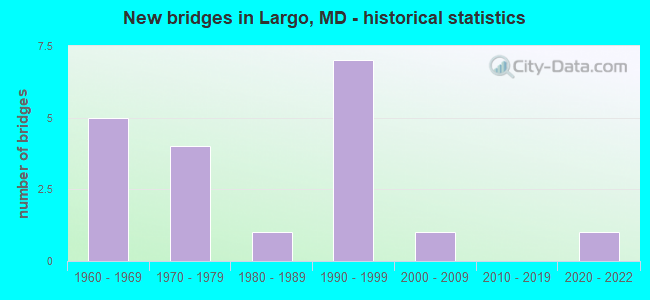
- New bridges - historical statistics
- 51960-1969
- 41970-1979
- 11980-1989
- 71990-1999
- 12000-2009
- 12020-2022


- Bridge Condition - Deck
- 50.0%Very good
- 33.3%Good
- 16.7%Poor

- Bridge Condition - Superstructure
- 16.7%Excellent
- 50.0%Very good
- 16.7%Good
- 16.7%Poor

- Bridge Condition - Substructure
- 33.3%Very good
- 50.0%Good
- 16.7%Satisfactory

- Bridge Condition - Channel
- 18.2%Very good
- 9.1%Good
- 36.4%Satisfactory
- 36.4%Fair

- Bridge Condition - Culverts
- 11.1%Good
- 88.9%Satisfactory
Find on map >> Show street view
Structure Number: 10000016015202, Location: 0.12 MILE EAST OF IS 95 (Lat: 38.892725, Lng: -76.845006), Route carried "on" structure: State highway 214, Year Built: 1964, Status: Open, Structure Length: 2.41m (7.91ft), Average Daily Traffic: 76,461 (year 2012), Truck Traffic: 8%, Average Future Daily Traffic: 95,338 (year 2032), Design Load: HS 20, Features Intersected: BR OF SOUTHWEST BR
Minimum Vertical Clearance: 30+ m (98+ ft), Kilometerpoint: 6.114, Lanes on structure: 4, Base Highway Network: Yes, Owner: State Highway Agency, Approaching Roadway Width: 21.3m (69.9ft), Material/Design: Concrete, Design/Construction: Culvert, Length of Maximum Span: 3.7m (12.1ft)
Condition: Channel: Satisfactory, Culverts: Satisfactory, Operating Rating: 32.7 metric tons, Method Used To Determine Operating Rating: Field evaluation and documented engineering judgment, Inventory Rating: 32.7 metric tons, Method Used To Determine Inventory Rating: Field evaluation and documented engineering judgment, Structural Evaluation: Equal to present minimum criteria, Waterway Adequacy: Equal to present desirable criteria, Approach Roadway Alignment: Equal to present desirable criteria, Designated Inspection Frequency: Every 24 months, Inspection Date: Febuary 2021
Find on map >> Show street view
Structure Number: 100000160153015, Location: 1.78 MILES S OF MD 202 (Lat: 38.891992, Lng: -76.846889), Route carried "on" structure: Interstate 95, Year Built: 2020, Status: Open, Structure Length: 6.12m (20.08ft), Average Daily Traffic: 224,775 (year 2015), Truck Traffic: 10%, Average Future Daily Traffic: 27,290 (year 2035), Features Intersected: MD 214
Minimum Vertical Clearance: 30+ m (98+ ft), Kilometerpoint: 23.712, Lanes on structure: 5, Lanes under structure: 4, Base Highway Network: Yes, Owner: State Highway Agency, Approaching Roadway Width: 20.7m (67.9ft), Material/Design: Steel continuous, Design/Construction: Stringer/Multi-beam, Number Of Spans In Main Unit: 2, Length of Maximum Span: 30.5m (100.1ft), Curb-To-Curb Width: 29.0m (95.1ft), Out-to-Out Width: 30.2m (99.1ft)
Condition: Deck: Very good, Superstructure: Excellent, Substructure: Very good, Operating Rating: 48.9 metric tons, Method Used To Determine Operating Rating: Load and Resistance Factor Rating (LRFR) rating reported by rating factor(RF) method using HL-93 loadings, Inventory Rating: 37.9 metric tons, Method Used To Determine Inventory Rating: Load and Resistance Factor Rating (LRFR) rating reported by rating factor(RF) method using HL-93 loadings, Structural Evaluation: Equal to present desirable criteria, Deck Geometry: Superior to present desirable criteria, Underclear: Meets minimum limits, Approach Roadway Alignment: Equal to present desirable criteria, Length Of Structure Improvement: 5.09m (16.70ft), Designated Inspection Frequency: Every 24 months, Inspection Date: December 2021, Bridge Improvement Cost: $747,000, Roadway Improvement Cost: $75,000, Total Project Cost: $822,000, Deck Structure Type: Concrete Cast-file-Place, Wearing Surface/Protective System: Wearing Surface: Integral Concrete
Find on map >> Show street view
Structure Number: 100000160156025, Location: 0.25 MILE SOUTH OF MD 214 (Lat: 38.888733, Lng: -76.845631), Route carried "on" structure: Interstate 95, Year Built: 1964, Status: Open, Structure Length: 1.92m (6.30ft), Average Daily Traffic: 102,413 (year 2006), Truck Traffic: 8%, Average Future Daily Traffic: 110,606 (year 2026), Design Load: HS 20, Features Intersected: SOUTHWEST BRANCH
Minimum Vertical Clearance: 30+ m (98+ ft), Kilometerpoint: 23.421, Lanes on structure: 8, Base Highway Network: Yes, Owner: State Highway Agency, Approaching Roadway Width: 24.4m (80.1ft), Material/Design: Concrete, Design/Construction: Culvert, Length of Maximum Span: 4.6m (15.1ft)
Condition: Channel: Fair, Culverts: Satisfactory, Operating Rating: 43.1 metric tons, Method Used To Determine Operating Rating: Load Factor (LF), Inventory Rating: 25.8 metric tons, Method Used To Determine Inventory Rating: Load Factor (LF), Structural Evaluation: Equal to present minimum criteria, Waterway Adequacy: Equal to present desirable criteria, Approach Roadway Alignment: Equal to present desirable criteria, Designated Inspection Frequency: Every 24 months, Inspection Date: March 2021
Find on map >> Show street view
Structure Number: 100000160156026, Location: 0.25 MILE SOUTH OF MD 214 (Lat: 38.888814, Lng: -76.846033), Route carried "on" structure: Interstate 95, Year Built: 1964, Status: Open, Structure Length: 1.92m (6.30ft), Average Daily Traffic: 102,413 (year 2006), Truck Traffic: 8%, Average Future Daily Traffic: 110,606 (year 2026), Design Load: HS 20, Features Intersected: SOUTHWEST BRANCH
Minimum Vertical Clearance: 30+ m (98+ ft), Kilometerpoint: 23.421, Lanes on structure: 8, Base Highway Network: Yes, Owner: State Highway Agency, Approaching Roadway Width: 24.4m (80.1ft), Material/Design: Concrete, Design/Construction: Culvert, Length of Maximum Span: 4.6m (15.1ft)
Condition: Channel: Satisfactory, Culverts: Satisfactory, Inventory Rating: 62.1 metric tons, Method Used To Determine Inventory Rating: Allowable Stress (AS), Structural Evaluation: Equal to present minimum criteria, Waterway Adequacy: Equal to present desirable criteria, Approach Roadway Alignment: Equal to present desirable criteria, Designated Inspection Frequency: Every 24 months, Inspection Date: March 2021
Find on map >> Show street view
Structure Number: 100000160241013, Location: 0.94 MILE EAST OF IS 95 (Lat: 38.898067, Lng: -76.832069), Route carried "on" structure: State highway 214, Year Built: 1993, Status: Open, Structure Length: 6.00m (19.69ft), Average Daily Traffic: 34,604 (year 2012), Truck Traffic: 8%, Average Future Daily Traffic: 46,715 (year 2032), Design Load: HS 20, Features Intersected: MD 202
Minimum Vertical Clearance: 30+ m (98+ ft), Kilometerpoint: 7.390, Lanes on structure: 4, Lanes under structure: 6, Base Highway Network: Yes, Owner: State Highway Agency, Approaching Roadway Width: 40.8m (133.9ft), Skew: 1 degrees, Material/Design: Steel continuous, Design/Construction: Stringer/Multi-beam, Number Of Spans In Main Unit: 2, Length of Maximum Span: 31.1m (102.0ft), Curb-To-Curb Width: 17.1m (56.1ft), Out-to-Out Width: 18.3m (60.0ft)
Condition: Deck: Very good, Superstructure: Very good, Substructure: Good, Operating Rating: 84.4 metric tons, Method Used To Determine Operating Rating: Load Factor (LF), Inventory Rating: 50.3 metric tons, Method Used To Determine Inventory Rating: Load Factor (LF), Structural Evaluation: Better than present minimum criteria, Deck Geometry: Somewhat better than minimum adequacy, Underclear: Equal to present minimum criteria, Approach Roadway Alignment: Equal to present minimum criteria, Designated Inspection Frequency: Every 24 months, Inspection Date: June 2021, Deck Structure Type: Concrete Cast-file-Place, Wearing Surface/Protective System: Wearing Surface: Monolithic Concrete
Find on map >> Show street view
Structure Number: 100000160241014, Location: 0.94 MILE EAST OF IS 95 (Lat: 38.898492, Lng: -76.831547), Route carried "on" structure: State highway 214, Year Built: 1993, Status: Open, Structure Length: 6.00m (19.69ft), Average Daily Traffic: 34,604 (year 2012), Truck Traffic: 8%, Average Future Daily Traffic: 46,715 (year 2032), Design Load: HS 20, Features Intersected: MD 202
Minimum Vertical Clearance: 30+ m (98+ ft), Kilometerpoint: 7.390, Lanes on structure: 4, Lanes under structure: 6, Base Highway Network: Yes, Owner: State Highway Agency, Approaching Roadway Width: 40.8m (133.9ft), Skew: 7 degrees, Material/Design: Steel continuous, Design/Construction: Stringer/Multi-beam, Number Of Spans In Main Unit: 2, Length of Maximum Span: 31.1m (102.0ft), Curb-To-Curb Width: 17.4m (57.1ft), Out-to-Out Width: 18.6m (61.0ft)
Condition: Deck: Very good, Superstructure: Good, Substructure: Good, Inventory Rating: 57.6 metric tons, Method Used To Determine Inventory Rating: Load Factor (LF), Structural Evaluation: Better than present minimum criteria, Deck Geometry: Somewhat better than minimum adequacy, Underclear: Equal to present minimum criteria, Approach Roadway Alignment: Equal to present minimum criteria, Designated Inspection Frequency: Every 24 months, Inspection Date: June 2021, Deck Structure Type: Concrete Cast-file-Place, Wearing Surface/Protective System: Wearing Surface: Monolithic Concrete
Find on map >> Show street view
Structure Number: 10000016024201, Location: 2.08 MILES N OF MD 202 (Lat: 38.894319, Lng: -76.839092), Route carried "on" structure: State highway 202C, Year Built: 1993, Status: Open, Structure Length: 7.25m (23.79ft), Average Daily Traffic: 3,930 (year 2006), Truck Traffic: 8%, Average Future Daily Traffic: 4,454 (year 2026), Design Load: HS 25 or greater, Features Intersected: MD 214
Minimum Vertical Clearance: 30+ m (98+ ft), Kilometerpoint: 3.347, Lanes on structure: 5, Lanes under structure: 9, Owner: State Highway Agency, Approaching Roadway Width: 19.2m (63.0ft), Material/Design: Steel, Design/Construction: Stringer/Multi-beam, Number Of Spans In Main Unit: 2, Length of Maximum Span: 38.4m (126.0ft), Curb or Sidewalk Widths: Left: 1.2m (3.9ft), Right: 1.2m (3.9ft), Curb-To-Curb Width: 19.2m (63.0ft), Out-to-Out Width: 22.3m (73.2ft)
Condition: Deck: Good, Superstructure: Very good, Substructure: Very good, Inventory Rating: 56.2 metric tons, Method Used To Determine Inventory Rating: Load Factor (LF), Structural Evaluation: Equal to present desirable criteria, Deck Geometry: Meets minimum limits, Underclear: Equal to present minimum criteria, Approach Roadway Alignment: Equal to present minimum criteria, Designated Inspection Frequency: Every 24 months, Inspection Date: January 2021, Deck Structure Type: Concrete Cast-file-Place, Wearing Surface/Protective System: Wearing Surface: Monolithic Concrete, Deck Protection: Epoxy Coated Reinforcing
Find on map >> Show street view
Structure Number: 200000P-030201, Location: 0.13 MI N OF ASHVILLE RD (Lat: 38.868464, Lng: -76.857650), Route carried "on" structure: County highway 87, Year Built: 2002, Status: Open, Structure Length: 3.44m (11.29ft), Average Daily Traffic: 26,212 (year 2019), Truck Traffic: 5%, Average Future Daily Traffic: 38,950 (year 2039), Design Load: HS 25 or greater, Features Intersected: RITCHIE BRANCH, Facility Carried by Structure: RITCHIE ROAD
Minimum Vertical Clearance: 30+ m (98+ ft), Kilometerpoint: 3.475, Lanes on structure: 4, Owner: County Highway Agency, Approaching Roadway Width: 17.1m (56.1ft), Skew: 3 degrees, Material/Design: Steel continuous, Design/Construction: Stringer/Multi-beam, Number Of Spans In Main Unit: 2, Length of Maximum Span: 16.5m (54.1ft), Curb or Sidewalk Widths: Left: 1.6m (5.2ft), Right: 1.6m (5.2ft), Curb-To-Curb Width: 17.1m (56.1ft), Out-to-Out Width: 21.1m (69.2ft)
Condition: Deck: Good, Superstructure: Very good, Substructure: Good, Channel: Very good, Structural Evaluation: Better than present minimum criteria, Deck Geometry: Somewhat better than minimum adequacy, Waterway Adequacy: Equal to present desirable criteria, Approach Roadway Alignment: Equal to present desirable criteria, Length Of Structure Improvement: 3.29m (10.79ft), Designated Inspection Frequency: Every 24 months, Inspection Date: May 2021, Deck Structure Type: Concrete Cast-file-Place, Wearing Surface/Protective System: Wearing Surface: Monolithic Concrete, Membrane: Epoxy, Deck Protection: Epoxy Coated Reinforcing
Find on map >> Show street view
Structure Number: 200000P-055703, Location: 0.92 MI E OF I-95 (Lat: 38.866886, Lng: -76.828217), Route carried "on" structure: County highway 97, Year Built: 1996, Status: Open, Structure Length: 0.79m (2.59ft), Average Daily Traffic: 22,859 (year 2021), Truck Traffic: 20%, Average Future Daily Traffic: 30,788 (year 2041), Features Intersected: TRIB TO THERESA CREEK, Facility Carried by Structure: WHITE HOUSE ROAD
Minimum Vertical Clearance: 30+ m (98+ ft), Kilometerpoint: 0.000, Lanes on structure: 2, Owner: County Highway Agency, Approaching Roadway Width: 7.3m (24.0ft), Material/Design: Concrete, Design/Construction: Culvert, Length of Maximum Span: 1.2m (3.9ft)
Condition: Channel: Fair, Culverts: Good, Operating Rating: 32.7 metric tons, Method Used To Determine Operating Rating: Field evaluation and documented engineering judgment, Inventory Rating: 32.7 metric tons, Method Used To Determine Inventory Rating: Field evaluation and documented engineering judgment, Structural Evaluation: Better than present minimum criteria, Waterway Adequacy: Meets minimum limits, Approach Roadway Alignment: Equal to present desirable criteria, Length Of Structure Improvement: 0.79m (2.59ft), Designated Inspection Frequency: Every 24 months, Inspection Date: May 2021
Find on map >> Show street view
Structure Number: 200000P-055903, Location: 0.5 MI. WEST OF MD 202 (Lat: 38.890383, Lng: -76.826358), Route carried "on" structure: County highway , Year Built: 1989, Status: Open, Structure Length: 0.82m (2.69ft), Average Daily Traffic: 650 (year 2019), Truck Traffic: 2%, Average Future Daily Traffic: 967 (year 2039), Design Load: HS 20, Features Intersected: TRIB TO SOUTHWEST BRANCH, Facility Carried by Structure: COLLEGE STATION DR
Minimum Vertical Clearance: 30+ m (98+ ft), Kilometerpoint: 0.000, Lanes on structure: 2, Owner: County Highway Agency, Approaching Roadway Width: 11.0m (36.1ft), Material/Design: Aluminum, Iron, Design/Construction: Culvert, Length of Maximum Span: 3.4m (11.2ft)
Condition: Channel: Good, Culverts: Satisfactory, Structural Evaluation: Equal to present minimum criteria, Waterway Adequacy: Better than present minimum criteria, Approach Roadway Alignment: Equal to present desirable criteria, Length Of Structure Improvement: 0.82m (2.69ft), Designated Inspection Frequency: Every 24 months, Inspection Date: May 2021
Find on map >> Show street view
Structure Number: 200000P-056003, Location: 0.5 MI SOUTH OF MD 214 (Lat: 38.887003, Lng: -76.835908), Route carried "on" structure: County highway 3465, Year Built: 1972, Status: Open, Structure Length: 0.82m (2.69ft), Average Daily Traffic: 18,564 (year 2019), Truck Traffic: 5%, Average Future Daily Traffic: 31,065 (year 2039), Design Load: HS 20, Features Intersected: TRIBUTARY TO SOUTHWEST B, Facility Carried by Structure: HARRY S TRUMAN DRI
Minimum Vertical Clearance: 30+ m (98+ ft), Kilometerpoint: 0.000, Lanes on structure: 4, Owner: County Highway Agency, Approaching Roadway Width: 29.3m (96.1ft), Skew: 4 degrees, Material/Design: Concrete, Design/Construction: Culvert, Length of Maximum Span: 3.4m (11.2ft)
Condition: Channel: Satisfactory, Culverts: Satisfactory, Inventory Rating: 74.8 metric tons, Method Used To Determine Inventory Rating: Load Factor (LF), Structural Evaluation: Equal to present minimum criteria, Waterway Adequacy: Better than present minimum criteria, Approach Roadway Alignment: Equal to present desirable criteria, Designated Inspection Frequency: Every 24 months, Inspection Date: May 2021
Find on map >> Show street view
Structure Number: 200000P-056103, Location: 0.2 MI WEST OF MD 202 (Lat: 38.888667, Lng: -76.829514), Route carried "on" structure: County highway 4638, Year Built: 1972, Status: Open, Structure Length: 1.46m (4.79ft), Average Daily Traffic: 11,386 (year 2017), Truck Traffic: 5%, Average Future Daily Traffic: 16,919 (year 2037), Design Load: HS 20, Features Intersected: TRIB TO SOUTHWEST BRANCH, Facility Carried by Structure: CAMPUS WAY SOUTH
Minimum Vertical Clearance: 30+ m (98+ ft), Kilometerpoint: 0.000, Lanes on structure: 4, Owner: County Highway Agency, Approaching Roadway Width: 29.3m (96.1ft), Skew: 5 degrees, Material/Design: Concrete, Design/Construction: Culvert, Length of Maximum Span: 2.4m (7.9ft)
Condition: Channel: Fair, Culverts: Satisfactory, Structural Evaluation: Equal to present minimum criteria, Waterway Adequacy: Somewhat better than minimum adequacy, Approach Roadway Alignment: Equal to present desirable criteria, Length Of Structure Improvement: 5.88m (19.29ft), Designated Inspection Frequency: Every 24 months, Inspection Date: April 2021
Find on map >> Show street view
Structure Number: 200000P-057202, Location: .1 MI N OF WHITE HOUSE RD (Lat: 38.871825, Lng: -76.812883), Route carried "on" structure: County highway 3195, Year Built: 1969, Status: Posted for load, Structure Length: 0.66m (2.17ft), Average Daily Traffic: 3,600 (year 2018), Truck Traffic: 2%, Average Future Daily Traffic: 5,350 (year 2038), Design Load: HS 20, Features Intersected: TRIB TO SOUTHWEST BRANCH, Facility Carried by Structure: WOODLAWN BOULEVARD
Minimum Vertical Clearance: 30+ m (98+ ft), Kilometerpoint: 0.000, Lanes on structure: 2, Owner: County Highway Agency, Approaching Roadway Width: 11.0m (36.1ft), Material/Design: Concrete, Design/Construction: Culvert, Length of Maximum Span: 3.0m (9.8ft)
Condition: Channel: Very good, Culverts: Satisfactory, Operating Rating: 29.0 metric tons, Method Used To Determine Operating Rating: Load Factor (LF), Inventory Rating: 16.3 metric tons, Method Used To Determine Inventory Rating: Load Factor (LF), Structural Evaluation: Meets minimum limits, Waterway Adequacy: Better than present minimum criteria, Approach Roadway Alignment: Equal to present desirable criteria, Bridge Posting: Required (Relationship of Operating Rating to Maximum Legal Load: 0.1 - 9.9% below), Length Of Structure Improvement: 1.89m (6.20ft), Designated Inspection Frequency: Every 12 months, Inspection Date: January 2021
Find on map >> Show street view
Structure Number: 200000P-058101, Location: 1.48 MILES S OF MD 214 (Lat: 38.876631, Lng: -76.826733), Route carried "on" structure: County highway 3465, Year Built: 1974, Status: Posted for load, Structure Length: 2.65m (8.69ft), Average Daily Traffic: 15,062 (year 2018), Truck Traffic: 5%, Average Future Daily Traffic: 22,390 (year 2038), Design Load: HS 20, Features Intersected: SOUTHWEST BRANCH, Facility Carried by Structure: HARRY S. TRUMAN DR
Minimum Vertical Clearance: 30+ m (98+ ft), Kilometerpoint: 2.381, Lanes on structure: 4, Owner: County Highway Agency, Approaching Roadway Width: 23.5m (77.1ft), Skew: 20 degrees, Material/Design: Prestressed concrete, Design/Construction: Stringer/Multi-beam, Number Of Spans In Main Unit: 2, Length of Maximum Span: 12.8m (42.0ft), Curb or Sidewalk Widths: Left: 1.8m (5.9ft), Right: 1.8m (5.9ft), Curb-To-Curb Width: 21.9m (71.9ft), Out-to-Out Width: 27.7m (90.9ft)
Condition: Deck: Poor, Superstructure: Poor, Substructure: Satisfactory, Channel: Satisfactory, Operating Rating: 35.8 metric tons, Method Used To Determine Operating Rating: Load Factor (LF), Inventory Rating: 21.8 metric tons, Method Used To Determine Inventory Rating: Load Factor (LF), Structural Evaluation: Meets minimum limits, Deck Geometry: Superior to present desirable criteria, Waterway Adequacy: Equal to present minimum criteria, Approach Roadway Alignment: Equal to present desirable criteria, Bridge Posting: Required (Relationship of Operating Rating to Maximum Legal Load: 0.1 - 9.9% below), Length Of Structure Improvement: 1.13m (3.71ft), Designated Inspection Frequency: Every 12 months, Inspection Date: Febuary 2021, Bridge Improvement Cost: $36,000, Roadway Improvement Cost: $4,000, Total Project Cost: $40,000, Wearing Surface/Protective System: Wearing Surface: Bituminous
Find on map >> Show street view
Structure Number: 200000P-058402, Location: 0.8 MI SOUTH OF MD 214 (Lat: 38.883772, Lng: -76.832450), Route carried "on" structure: County highway 3465, Year Built: 1972, Status: Posted for load, Structure Length: 1.28m (4.20ft), Average Daily Traffic: 7,523 (year 2017), Truck Traffic: 5%, Average Future Daily Traffic: 11,180 (year 2037), Design Load: H 20, Features Intersected: TRIB. TO SOUTHWEST BR., Facility Carried by Structure: HARRY S. TRUMAN DR
Minimum Vertical Clearance: 30+ m (98+ ft), Kilometerpoint: 0.000, Lanes on structure: 4, Owner: County Highway Agency, Approaching Roadway Width: 29.3m (96.1ft), Skew: 23 degrees, Material/Design: Concrete, Design/Construction: Culvert, Length of Maximum Span: 4.0m (13.1ft), Curb or Sidewalk Widths: Left: 1.2m (3.9ft), Right: 1.2m (3.9ft)
Condition: Channel: Fair, Culverts: Satisfactory, Operating Rating: 29.0 metric tons, Method Used To Determine Operating Rating: Load Factor (LF), Inventory Rating: 16.3 metric tons, Method Used To Determine Inventory Rating: Load Factor (LF), Structural Evaluation: Meets minimum limits, Waterway Adequacy: Equal to present minimum criteria, Approach Roadway Alignment: Equal to present desirable criteria, Bridge Posting: Required (Relationship of Operating Rating to Maximum Legal Load: 0.1 - 9.9% below), Designated Inspection Frequency: Every 12 months, Inspection Date: January 2021
Find on map >> Show street view
Structure Number: 100000160153015, Location: 0.94 MILE SOUTH OF MD 202 (Lat: 38.891992, Lng: -76.846889), Route carried "under" structure: State highway 214, Year Built: 1963, Structure Length: 0. m, Average Daily Traffic: 76,461 (year 2009), Features Intersected: MD 214, Facility Carried by Structure: IS 95/495
Minimum Vertical Clearance: 5.49m (18.01ft), Kilometerpoint: 5.905, Lanes on structure: 4, Lanes under structure: 4, Material/Design: Steel, Design/Construction: Stringer/Multi-beam, Length of Maximum Span: 15.9m (52.2ft)
Find on map >> Show street view
Structure Number: 100000160241013, Location: 3.3 MILES NORTH OF MD 193 (Lat: 38.898067, Lng: -76.832069), Route carried "under" structure: State highway 202, Year Built: 1993, Structure Length: 0. m, Average Daily Traffic: 56,032 (year 2012), Truck Traffic: 8%, Features Intersected: MD 202, Facility Carried by Structure: MD 214 EBR
Minimum Vertical Clearance: 5.49m (18.01ft), Kilometerpoint: 12.309, Lanes on structure: 4, Lanes under structure: 6, Material/Design: Steel continuous, Design/Construction: Stringer/Multi-beam, Length of Maximum Span: 31.1m (102.0ft)
Find on map >> Show street view
Structure Number: 100000160241014, Location: 3.3 MILES NORTH OF MD 193 (Lat: 38.898492, Lng: -76.831547), Route carried "under" structure: State highway 202, Year Built: 1993, Structure Length: 0. m, Average Daily Traffic: 56,302 (year 2012), Truck Traffic: 8%, Features Intersected: MD 202, Facility Carried by Structure: MD 214 WBR
Minimum Vertical Clearance: 5.49m (18.01ft), Kilometerpoint: 12.309, Lanes on structure: 4, Lanes under structure: 6, Material/Design: Steel continuous, Design/Construction: Stringer/Multi-beam, Length of Maximum Span: 31.1m (102.0ft)
Find on map >> Show street view
Structure Number: 10000016024201, Location: 0.46 MILE EAST OF IS 95 (Lat: 38.894319, Lng: -76.839092), Route carried "under" structure: State highway 214, Year Built: 1993, Structure Length: 0. m, Average Daily Traffic: 76,461 (year 2009), Truck Traffic: 8%, Features Intersected: MD 214, Facility Carried by Structure: MD 202C
Minimum Vertical Clearance: 4.88m (16.01ft), Kilometerpoint: 6.645, Lanes on structure: 5, Lanes under structure: 9, Material/Design: Steel, Design/Construction: Stringer/Multi-beam, Length of Maximum Span: 38.4m (126.0ft)