Bridge Statistics for Lucas Valley-Marinwood, California (CA)
Condition, Traffic, Stress, Structural Evaluation, Project Costs
- National Bridge Inventory (NBI) Statistics
- 11Number of bridges
- 75ft / 22.9mTotal length
- 327,870Total average daily traffic
- 380Total average daily truck traffic
- National Bridge Inventory (NBI) Registered Bridges for Lucas Valley-Marinwood
- No street view available for this location
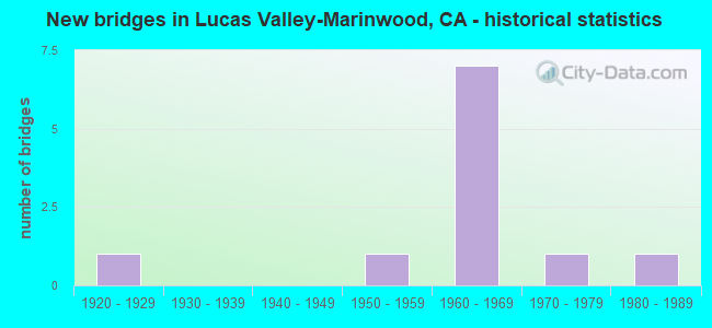
- New bridges - historical statistics
- 11920-1929
- 11950-1959
- 71960-1969
- 11970-1979
- 11980-1989


- Bridge Condition - Deck
- 25.0%Good
- 25.0%Satisfactory
- 50.0%Fair

- Bridge Condition - Superstructure
- 50.0%Good
- 12.5%Satisfactory
- 37.5%Fair

- Bridge Condition - Substructure
- 75.0%Good
- 12.5%Satisfactory
- 12.5%Fair

- Bridge Condition - Channel
- 42.9%Very good
- 14.3%Good
- 28.6%Satisfactory
- 14.3%Fair
Find on map >> Show street view
Structure Number: 27 0004, Location: 04-MRN-101-15.35 (Lat: 38.030339, Lng: -122.537236), Route carried "on" structure: US 101, Year Built: 1952, Year Reconstructed: 1987, Status: Open, Structure Length: 2.68m (8.79ft), Average Daily Traffic: 151,000 (year 2009), Average Future Daily Traffic: 219,074 (year 2038), Design Load: HS 20, Features Intersected: MILLER CREEK
Minimum Vertical Clearance: 30+ m (98+ ft), Kilometerpoint: 15.350, Lanes on structure: 9, Base Highway Network: Yes (Inventory Route: 1, Subroute: 1), Owner: State Highway Agency, Approaching Roadway Width: 41.8m (137.1ft), Skew: 32 degrees, Material/Design: Concrete continuous, Design/Construction: Slab, Number Of Spans In Main Unit: 3, Length of Maximum Span: 9.1m (29.9ft), Curb or Sidewalk Widths: Left: 0.2m (0.7ft), Right: 0.2m (0.7ft), Curb-To-Curb Width: 42.0m (137.8ft), Out-to-Out Width: 43.2m (141.7ft)
Condition: Deck: Fair, Superstructure: Fair, Substructure: Good, Channel: Fair, Operating Rating: 34.7 metric tons, Method Used To Determine Operating Rating: Load and Resistance Factor Rating (LRFR) rating reported by rating factor(RF) method using HL-93 loadings, Inventory Rating: 24.6 metric tons, Method Used To Determine Inventory Rating: Load and Resistance Factor Rating (LRFR) rating reported by rating factor(RF) method using HL-93 loadings, Structural Evaluation: Somewhat better than minimum adequacy, Deck Geometry: Superior to present desirable criteria, Waterway Adequacy: Equal to present desirable criteria, Approach Roadway Alignment: Equal to present desirable criteria, Designated Inspection Frequency: Every 24 months, Inspection Date: March 2021, Deck Structure Type: Concrete Cast-file-Place, Wearing Surface/Protective System: Wearing Surface: Bituminous
Find on map >> Show street view
Structure Number: 27 0082, Location: 04-MRN-101-15.57 (Lat: 38.033544, Lng: -122.537650), Route carried "on" structure: County highway , Year Built: 1961, Status: Open, Structure Length: 8.81m (28.90ft), Average Daily Traffic: 9,280 (year 1998), Truck Traffic: 1%, Average Future Daily Traffic: 16,355 (year 2043), Design Load: HS 20, Features Intersected: U.S. HIGHWAY 101, Facility Carried by Structure: MILLER CREEK ROAD
Minimum Vertical Clearance: 30+ m (98+ ft), Kilometerpoint: 0.000, Lanes on structure: 2, Lanes under structure: 10, Owner: State Highway Agency, Approaching Roadway Width: 11.3m (37.1ft), Material/Design: Prestressed concrete continuous, Design/Construction: Stringer/Multi-beam, Number Of Spans In Main Unit: 4, Length of Maximum Span: 21.9m (71.9ft), Curb or Sidewalk Widths: Left: 1.7m (5.6ft), Right: 0.1m (0.3ft), Curb-To-Curb Width: 9.8m (32.2ft), Out-to-Out Width: 12.6m (41.3ft)
Condition: Deck: Fair, Superstructure: Good, Substructure: Fair, Operating Rating: 28.8 metric tons, Method Used To Determine Operating Rating: Load and Resistance Factor Rating (LRFR) rating reported by rating factor(RF) method using HL-93 loadings, Inventory Rating: 22.0 metric tons, Method Used To Determine Inventory Rating: Load and Resistance Factor Rating (LRFR) rating reported by rating factor(RF) method using HL-93 loadings, Structural Evaluation: Somewhat better than minimum adequacy, Deck Geometry: Meets minimum limits, Underclear: Meets minimum limits, Approach Roadway Alignment: Equal to present desirable criteria, Designated Inspection Frequency: Every 24 months, Inspection Date: March 2021, Deck Structure Type: Concrete Cast-file-Place
Find on map >> Show street view
Structure Number: 27C0083, Location: 0.3 MI INTX LUCAS VLY RD (Lat: 38.030358, Lng: -122.545153), Route carried "on" structure: County highway , Year Built: 1970, Status: Open, Structure Length: 1.62m (5.31ft), Average Daily Traffic: 3,830 (year 1977), Truck Traffic: 3%, Average Future Daily Traffic: 5,732 (year 2043), Design Load: HS 20, Features Intersected: MILLER CREEK, Facility Carried by Structure: LAS GALLINAS AVE
Minimum Vertical Clearance: 30+ m (98+ ft), Kilometerpoint: 0.000, Lanes on structure: 3, Owner: County Highway Agency, Approaching Roadway Width: 19.5m (64.0ft), Skew: 2 degrees, Material/Design: Concrete continuous, Design/Construction: Slab, Number Of Spans In Main Unit: 2, Length of Maximum Span: 7.9m (25.9ft), Curb or Sidewalk Widths: Left: 1.7m (5.6ft), Right: 1.7m (5.6ft), Curb-To-Curb Width: 19.5m (64.0ft), Out-to-Out Width: 23.5m (77.1ft)
Condition: Deck: Good, Superstructure: Good, Substructure: Good, Channel: Good, Operating Rating: 76.1 metric tons, Method Used To Determine Operating Rating: Load Factor (LF), Inventory Rating: 45.7 metric tons, Method Used To Determine Inventory Rating: Load Factor (LF), Structural Evaluation: Better than present minimum criteria, Deck Geometry: Superior to present desirable criteria, Waterway Adequacy: Better than present minimum criteria, Approach Roadway Alignment: Equal to present desirable criteria, Designated Inspection Frequency: Every 48 months, Inspection Date: August 2021, Deck Structure Type: Concrete Cast-file-Place, Wearing Surface/Protective System: Wearing Surface: Bituminous
Find on map >> Show street view
Structure Number: 27C0132, Location: 0.08 MI N LUCAS VALLEY RD (Lat: 38.029381, Lng: -122.576219), Route carried "on" structure: County highway , Year Built: 1962, Status: Open, Structure Length: 2.69m (8.83ft), Average Daily Traffic: 500 (year 1973), Truck Traffic: 2%, Average Future Daily Traffic: 764 (year 2041), Design Load: H 20, Features Intersected: MILLER CREEK, Facility Carried by Structure: MOUNT SHASTA DR
Minimum Vertical Clearance: 30+ m (98+ ft), Kilometerpoint: 0.000, Lanes on structure: 2, Owner: County Highway Agency, Approaching Roadway Width: 12.2m (40.0ft), Skew: 3 degrees, Material/Design: Concrete continuous, Design/Construction: Slab, Number Of Spans In Main Unit: 3, Length of Maximum Span: 8.8m (28.9ft), Curb or Sidewalk Widths: Left: 1.5m (4.9ft), Right: 1.5m (4.9ft), Curb-To-Curb Width: 12.2m (40.0ft), Out-to-Out Width: 15.7m (51.5ft)
Condition: Deck: Fair, Superstructure: Fair, Substructure: Good, Channel: Satisfactory, Operating Rating: 66.1 metric tons, Method Used To Determine Operating Rating: Load Factor (LF), Inventory Rating: 39.9 metric tons, Method Used To Determine Inventory Rating: Load Factor (LF), Structural Evaluation: Somewhat better than minimum adequacy, Deck Geometry: Equal to present desirable criteria, Waterway Adequacy: Better than present minimum criteria, Approach Roadway Alignment: Equal to present desirable criteria, Designated Inspection Frequency: Every 24 months, Inspection Date: August 2021, Deck Structure Type: Concrete Cast-file-Place
Find on map >> Show street view
Structure Number: 27C0133, Location: LUCAS VLY RD INTERSECTION (Lat: 38.032156, Lng: -122.583653), Route carried "on" structure: County highway , Year Built: 1963, Status: Open, Structure Length: 1.92m (6.30ft), Average Daily Traffic: 800 (year 1973), Truck Traffic: 2%, Average Future Daily Traffic: 1,091 (year 2041), Design Load: HS 20+Mod, Features Intersected: MILLER CREEK, Facility Carried by Structure: MT MCKINLEY RD
Minimum Vertical Clearance: 30+ m (98+ ft), Kilometerpoint: 0.000, Lanes on structure: 2, Owner: County Highway Agency, Approaching Roadway Width: 12.2m (40.0ft), Material/Design: Concrete continuous, Design/Construction: Slab, Number Of Spans In Main Unit: 3, Length of Maximum Span: 7.3m (24.0ft), Curb or Sidewalk Widths: Left: 1.5m (4.9ft), Right: 0.6m (2.0ft), Curb-To-Curb Width: 12.2m (40.0ft), Out-to-Out Width: 14.8m (48.6ft)
Condition: Deck: Fair, Superstructure: Fair, Substructure: Good, Channel: Very good, Operating Rating: 51.8 metric tons, Method Used To Determine Operating Rating: Load Factor (LF), Inventory Rating: 31.1 metric tons, Method Used To Determine Inventory Rating: Load Factor (LF), Structural Evaluation: Somewhat better than minimum adequacy, Deck Geometry: Equal to present desirable criteria, Waterway Adequacy: Better than present minimum criteria, Approach Roadway Alignment: Equal to present desirable criteria, Designated Inspection Frequency: Every 24 months, Inspection Date: August 2021, Deck Structure Type: Concrete Cast-file-Place
Find on map >> Show street view
Structure Number: 27C0134, Location: 0.06 MI N LUCAS VALLEY RD (Lat: 38.026081, Lng: -122.568756), Route carried "on" structure: County highway , Year Built: 1925, Status: Open, Structure Length: 0.92m (3.02ft), Average Daily Traffic: 980 (year 1973), Truck Traffic: 2%, Average Future Daily Traffic: 1,308 (year 2041), Features Intersected: MILLER CREEK, Facility Carried by Structure: MOUNT LASSEN DR SB
Minimum Vertical Clearance: 30+ m (98+ ft), Kilometerpoint: 0.000, Lanes on structure: 1, Owner: County Highway Agency, Approaching Roadway Width: 6.1m (20.0ft), Skew: 3 degrees, Material/Design: Concrete, Design/Construction: Slab, Number Of Spans In Main Unit: 1, Length of Maximum Span: 8.8m (28.9ft), Curb or Sidewalk Widths: Left: 1.5m (4.9ft), Right: 0.2m (0.7ft), Curb-To-Curb Width: 4.3m (14.1ft), Out-to-Out Width: 7.2m (23.6ft)
Condition: Deck: Good, Superstructure: Good, Substructure: Satisfactory, Channel: Very good, Operating Rating: 35.3 metric tons, Method Used To Determine Operating Rating: Load Factor (LF), Inventory Rating: 21.1 metric tons, Method Used To Determine Inventory Rating: Load Factor (LF), Structural Evaluation: Somewhat better than minimum adequacy, Deck Geometry: High priority of replacement, Waterway Adequacy: Better than present minimum criteria, Approach Roadway Alignment: Equal to present desirable criteria, Designated Inspection Frequency: Every 24 months, Inspection Date: August 2021, Deck Structure Type: Concrete Cast-file-Place
Find on map >> Show street view
Structure Number: 27C0135, Location: 0.06 MI N LUCAS VALLEY RD (Lat: 38.026097, Lng: -122.568606), Route carried "on" structure: County highway , Year Built: 1965, Status: Open, Structure Length: 2.38m (7.81ft), Average Daily Traffic: 980 (year 1973), Truck Traffic: 2%, Average Future Daily Traffic: 1,308 (year 2041), Design Load: HS 20, Features Intersected: MILLER CREEK, Facility Carried by Structure: MOUNT LASSEN DR NB
Minimum Vertical Clearance: 30+ m (98+ ft), Kilometerpoint: 0.000, Lanes on structure: 1, Owner: County Highway Agency, Approaching Roadway Width: 6.1m (20.0ft), Skew: 3 degrees, Material/Design: Concrete continuous, Design/Construction: Slab, Number Of Spans In Main Unit: 3, Length of Maximum Span: 9.8m (32.2ft), Curb or Sidewalk Widths: Left: 0.4m (1.3ft), Right: 1.2m (3.9ft), Curb-To-Curb Width: 6.1m (20.0ft), Out-to-Out Width: 8.3m (27.2ft)
Condition: Deck: Satisfactory, Superstructure: Satisfactory, Substructure: Good, Channel: Satisfactory, Operating Rating: 53.8 metric tons, Method Used To Determine Operating Rating: Load Factor (LF), Inventory Rating: 32.4 metric tons, Method Used To Determine Inventory Rating: Load Factor (LF), Structural Evaluation: Equal to present minimum criteria, Deck Geometry: High priority of corrective action, Waterway Adequacy: Better than present minimum criteria, Approach Roadway Alignment: Equal to present desirable criteria, Designated Inspection Frequency: Every 48 months, Inspection Date: August 2019, Deck Structure Type: Concrete Cast-file-Place
Find on map >> Show street view
Structure Number: 27C0155, Location: 0.1 MI N LUCAS VALLEY RD (Lat: 38.034711, Lng: -122.587219), Route carried "on" structure: County highway , Year Built: 1987, Status: Open, Structure Length: 1.89m (6.20ft), Average Daily Traffic: 500 (year 1988), Truck Traffic: 2%, Average Future Daily Traffic: 644 (year 2036), Design Load: HS 20, Features Intersected: MILLER CREEK, Facility Carried by Structure: BRIDGEGATE DR
Minimum Vertical Clearance: 30+ m (98+ ft), Kilometerpoint: 0.000, Lanes on structure: 2, Owner: County Highway Agency, Approaching Roadway Width: 11.0m (36.1ft), Material/Design: Prestressed concrete, Design/Construction: Tee Beam, Number Of Spans In Main Unit: 1, Length of Maximum Span: 18.3m (60.0ft), Curb or Sidewalk Widths: Left: 1.4m (4.6ft), Right: 1.4m (4.6ft), Curb-To-Curb Width: 11.0m (36.1ft), Out-to-Out Width: 14.3m (46.9ft)
Condition: Deck: Satisfactory, Superstructure: Good, Substructure: Good, Channel: Very good, Operating Rating: 79.1 metric tons, Method Used To Determine Operating Rating: Load Factor (LF), Inventory Rating: 32.4 metric tons, Method Used To Determine Inventory Rating: Load Factor (LF), Structural Evaluation: Better than present minimum criteria, Deck Geometry: Better than present minimum criteria, Waterway Adequacy: Equal to present desirable criteria, Approach Roadway Alignment: Better than present minimum criteria, Designated Inspection Frequency: Every 48 months, Inspection Date: September 2018, Deck Structure Type: Concrete Cast-file-Place
Find on map >> Show street view
Structure Number: 27 0082, Location: 04-MRN-101-15.57 (Lat: 38.033544, Lng: -122.537650), Route carried "under" structure: US 101, Year Built: 1961, Structure Length: 0. m, Average Daily Traffic: 150,000 (year 2009), Features Intersected: U.S. HIGHWAY 101, Facility Carried by Structure: MILLER CREEK ROAD
Minimum Vertical Clearance: 4.88m (16.01ft), Kilometerpoint: 15.570, Lanes on structure: 2, Lanes under structure: 8, Material/Design: Prestressed concrete continuous, Design/Construction: Stringer/Multi-beam, Length of Maximum Span: 21.9m (71.9ft)
Find on map >> Show street view
Structure Number: 27 0082, Location: 04-MRN-101-15.57 (Lat: 38.033544, Lng: -122.537650), Route carried "under" structure: Ramp US 101, Year Built: 1961, Structure Length: 0. m, Average Daily Traffic: 5,000 (year 2001), Truck Traffic: 1%, Features Intersected: U.S. HIGHWAY 101, Facility Carried by Structure: MILLER CREEK ROAD
Minimum Vertical Clearance: 4.90m (16.08ft), Kilometerpoint: 15.570, Lanes on structure: 2, Lanes under structure: 1, Material/Design: Prestressed concrete continuous, Design/Construction: Stringer/Multi-beam, Length of Maximum Span: 21.9m (71.9ft)
Find on map >> Show street view
Structure Number: 27 0082, Location: 04-MRN-101-15.57 (Lat: 38.033544, Lng: -122.537650), Route carried "under" structure: Ramp US 101, Year Built: 1961, Structure Length: 0. m, Average Daily Traffic: 5,000 (year 2001), Truck Traffic: 1%, Features Intersected: U.S. HIGHWAY 101, Facility Carried by Structure: MILLER CREEK ROAD
Minimum Vertical Clearance: 5.20m (17.06ft), Kilometerpoint: 15.570, Lanes on structure: 2, Lanes under structure: 1, Material/Design: Prestressed concrete continuous, Design/Construction: Stringer/Multi-beam, Length of Maximum Span: 21.9m (71.9ft)