Bridge Statistics for Lynwood, California (CA)
Condition, Traffic, Stress, Structural Evaluation, Project Costs
- National Bridge Inventory (NBI) Statistics
- 61Number of bridges
- 1,542ft / 470mTotal length
- 4,319,200Total average daily traffic
- 359,559Total average daily truck traffic
- National Bridge Inventory (NBI) Registered Bridges for Lynwood
- No street view available for this location
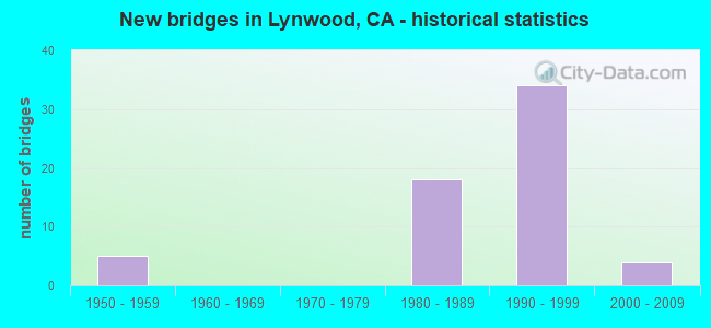
- New bridges - historical statistics
- 51950-1959
- 181980-1989
- 341990-1999
- 42000-2009


- Bridge Condition - Deck
- 72.7%Good
- 27.3%Fair

- Bridge Condition - Superstructure
- 18.2%Very good
- 72.7%Good
- 9.1%Fair

- Bridge Condition - Substructure
- 18.2%Very good
- 63.6%Good
- 18.2%Fair
Find on map >> Show street view
Structure Number: 53 082, Location: 07-LA-710-12.89-LBCH (Lat: 33.874233, Lng: -118.193875), Route carried "on" structure: City street , Year Built: 1953, Status: Open, Structure Length: 7.99m (26.21ft), Average Daily Traffic: 18,900 (year 2009), Truck Traffic: 21%, Average Future Daily Traffic: 25,758 (year 2042), Design Load: HS 20, Features Intersected: INTERSTATE 710, Facility Carried by Structure: ARTESIA BLVD
Minimum Vertical Clearance: 30+ m (98+ ft), Kilometerpoint: 0.000, Lanes on structure: 5, Lanes under structure: 11, Owner: State Highway Agency, Approaching Roadway Width: 25.6m (84.0ft), Skew: 21 degrees, Material/Design: Concrete continuous, Design/Construction: Box Beam or Girders - Multiple, Number Of Spans In Main Unit: 4, Length of Maximum Span: 20.4m (66.9ft), Curb or Sidewalk Widths: Left: 1.5m (4.9ft), Right: 1.5m (4.9ft), Curb-To-Curb Width: 25.6m (84.0ft), Out-to-Out Width: 29.3m (96.1ft)
Condition: Deck: Good, Superstructure: Good, Substructure: Good, Operating Rating: 43.7 metric tons, Method Used To Determine Operating Rating: Load and Resistance Factor Rating (LRFR) rating reported by rating factor(RF) method using HL-93 loadings, Inventory Rating: 31.1 metric tons, Method Used To Determine Inventory Rating: Load and Resistance Factor Rating (LRFR) rating reported by rating factor(RF) method using HL-93 loadings, Structural Evaluation: Better than present minimum criteria, Deck Geometry: Superior to present desirable criteria, Underclear: High priority of corrective action, Approach Roadway Alignment: Superior to present desirable criteria, Designated Inspection Frequency: Every 24 months, Inspection Date: April 2020, Deck Structure Type: Concrete Cast-file-Place
Find on map >> Show street view
Structure Number: 53 0827, Location: 07-LA-710-16.99-LYN (Lat: 33.930789, Lng: -118.179181), Route carried "on" structure: City street L100, Year Built: 1956, Status: Open, Structure Length: 6.77m (22.21ft), Average Daily Traffic: 64,000 (year 2015), Truck Traffic: 15%, Average Future Daily Traffic: 98,500 (year 2037), Design Load: HS 20, Features Intersected: ROUTE 710, Facility Carried by Structure: IMPERIAL HIGHWAY
Minimum Vertical Clearance: 30+ m (98+ ft), Kilometerpoint: 0.000, Lanes on structure: 4, Lanes under structure: 12, Owner: State Highway Agency, Approaching Roadway Width: 22.6m (74.1ft), Skew: 30 degrees, Material/Design: Concrete continuous, Design/Construction: Box Beam or Girders - Multiple, Number Of Spans In Main Unit: 4, Length of Maximum Span: 20.7m (67.9ft), Curb or Sidewalk Widths: Left: 1.5m (4.9ft), Right: 1.5m (4.9ft), Curb-To-Curb Width: 22.6m (74.1ft), Out-to-Out Width: 28.0m (91.9ft)
Condition: Deck: Good, Superstructure: Fair, Substructure: Good, Operating Rating: 42.8 metric tons, Method Used To Determine Operating Rating: Load and Resistance Factor Rating (LRFR) rating reported by rating factor(RF) method using HL-93 loadings, Inventory Rating: 33.0 metric tons, Method Used To Determine Inventory Rating: Load and Resistance Factor Rating (LRFR) rating reported by rating factor(RF) method using HL-93 loadings, Structural Evaluation: Somewhat better than minimum adequacy, Deck Geometry: Superior to present desirable criteria, Underclear: High priority of corrective action, Approach Roadway Alignment: Superior to present desirable criteria, Designated Inspection Frequency: Every 24 months, Inspection Date: May 2020, Deck Structure Type: Concrete Cast-file-Place
Find on map >> Show street view
Structure Number: 53 2413K, Location: 07-LA-710-R15.20-LYN (Lat: 33.907033, Lng: -118.183164), Route carried "on" structure: Ramp Interstate 710, Year Built: 1990, Status: Open, Structure Length: 16.86m (55.31ft), Average Daily Traffic: 37,000 (year 2007), Truck Traffic: 21%, Average Future Daily Traffic: 51,337 (year 2042), Design Load: HS 20+Mod, Features Intersected: E105-S710 CONNECTOR RAMP
Minimum Vertical Clearance: 30+ m (98+ ft), Kilometerpoint: 15.200, Lanes on structure: 1, Lanes under structure: 3, Base Highway Network: Yes (Inventory Route: 7, Subroute: 1), Owner: State Highway Agency, Approaching Roadway Width: 7.3m (24.0ft), Material/Design: Prestressed concrete continuous, Design/Construction: Box Beam or Girders - Multiple, Number Of Spans In Main Unit: 3, Length of Maximum Span: 67.4m (221.1ft), Curb-To-Curb Width: 7.3m (24.0ft), Out-to-Out Width: 8.4m (27.6ft)
Condition: Deck: Good, Superstructure: Good, Substructure: Good, Operating Rating: 54.1 metric tons, Method Used To Determine Operating Rating: Assigned rating based on Load Factor Design (LFD) reported in metric tons, Inventory Rating: 32.4 metric tons, Method Used To Determine Inventory Rating: Assigned rating based on Load Factor Design (LFD) reported in metric tons, Structural Evaluation: Better than present minimum criteria, Deck Geometry: Better than present minimum criteria, Underclear: Equal to present minimum criteria, Approach Roadway Alignment: Equal to present minimum criteria, Designated Inspection Frequency: Every 24 months, Inspection Date: May 2020, Deck Structure Type: Concrete Cast-file-Place
Find on map >> Show street view
Structure Number: 53 2414F, Location: 07-LA-105-R13.65-LYN (Lat: 33.910400, Lng: -118.181311), Route carried "on" structure: Ramp Interstate 105, Year Built: 1993, Status: Open, Structure Length: 52.58m (172.51ft), Average Daily Traffic: 15,197 (year 2010), Truck Traffic: 2%, Average Future Daily Traffic: 16,631 (year 2037), Design Load: HS 20+Mod, Features Intersected: ROUTE 105 & LRT, 710
Minimum Vertical Clearance: 5.08m (16.67ft), Kilometerpoint: 13.650, Lanes on structure: 2, Lanes under structure: 21, Base Highway Network: Yes (Inventory Route: 1, Subroute: 1), Owner: State Highway Agency, Approaching Roadway Width: 11.7m (38.4ft), Material/Design: Prestressed concrete continuous, Design/Construction: Box Beam or Girders - Multiple, Number Of Spans In Main Unit: 10, Length of Maximum Span: 70.6m (231.6ft), Curb-To-Curb Width: 11.7m (38.4ft), Out-to-Out Width: 12.8m (42.0ft)
Condition: Deck: Good, Superstructure: Good, Substructure: Good, Operating Rating: 54.1 metric tons, Method Used To Determine Operating Rating: Assigned rating based on Load Factor Design (LFD) reported in metric tons, Inventory Rating: 32.4 metric tons, Method Used To Determine Inventory Rating: Assigned rating based on Load Factor Design (LFD) reported in metric tons, Structural Evaluation: Better than present minimum criteria, Deck Geometry: Equal to present minimum criteria, Underclear: Meets minimum limits, Approach Roadway Alignment: Somewhat better than minimum adequacy, Designated Inspection Frequency: Every 24 months, Inspection Date: June 2020, Deck Structure Type: Concrete Cast-file-Place, Wearing Surface/Protective System: Wearing Surface: Epoxy Overlay
Find on map >> Show street view
Structure Number: 53 2415G, Location: 07-LA-710-R15.44-LYN (Lat: 33.909083, Lng: -118.180339), Route carried "on" structure: Ramp Interstate 710, Year Built: 1990, Year Reconstructed: 1991, Status: Open, Structure Length: 81.46m (267.26ft), Average Daily Traffic: 16,300 (year 2009), Truck Traffic: 2%, Average Future Daily Traffic: 20,172 (year 2042), Design Load: HS 20+Mod, Features Intersected: RTES 105 & 710,LRT,CONN
Minimum Vertical Clearance: 30+ m (98+ ft), Kilometerpoint: 15.440, Lanes on structure: 2, Lanes under structure: 26, Base Highway Network: Yes (Inventory Route: 7, Subroute: 1), Owner: State Highway Agency, Approaching Roadway Width: 10.7m (35.1ft), Material/Design: Prestressed concrete continuous, Design/Construction: Box Beam or Girders - Multiple, Number Of Spans In Main Unit: 14, Length of Maximum Span: 72.8m (238.8ft), Curb-To-Curb Width: 10.5m (34.4ft), Out-to-Out Width: 11.6m (38.1ft)
Condition: Deck: Good, Superstructure: Good, Substructure: Good, Operating Rating: 54.1 metric tons, Method Used To Determine Operating Rating: Assigned rating based on Load Factor Design (LFD) reported in metric tons, Inventory Rating: 32.4 metric tons, Method Used To Determine Inventory Rating: Assigned rating based on Load Factor Design (LFD) reported in metric tons, Structural Evaluation: Better than present minimum criteria, Deck Geometry: Better than present minimum criteria, Underclear: Somewhat better than minimum adequacy, Approach Roadway Alignment: Somewhat better than minimum adequacy, Designated Inspection Frequency: Every 24 months, Inspection Date: May 2020, Deck Structure Type: Concrete Cast-file-Place
Find on map >> Show street view
Structure Number: 53 2416F, Location: 07-LA-710-R16.01-LYN (Lat: 33.914508, Lng: -118.184164), Route carried "on" structure: Ramp Interstate 710, Year Built: 1992, Status: Open, Structure Length: 60.11m (197.21ft), Average Daily Traffic: 16,300 (year 2009), Truck Traffic: 2%, Average Future Daily Traffic: 20,172 (year 2042), Design Load: HS 20+Mod, Features Intersected: MLK JR-S710, WRIGHT RD
Minimum Vertical Clearance: 7.47m (24.51ft), Kilometerpoint: 16.010, Lanes on structure: 1, Lanes under structure: 4, Base Highway Network: Yes (Inventory Route: 7, Subroute: 1), Owner: State Highway Agency, Approaching Roadway Width: 8.5m (27.9ft), Material/Design: Prestressed concrete continuous, Design/Construction: Box Beam or Girders - Multiple, Number Of Spans In Main Unit: 13, Length of Maximum Span: 48.5m (159.1ft), Curb-To-Curb Width: 8.5m (27.9ft), Out-to-Out Width: 9.6m (31.5ft)
Condition: Deck: Good, Superstructure: Good, Substructure: Fair, Operating Rating: 54.1 metric tons, Method Used To Determine Operating Rating: Assigned rating based on Load Factor Design (LFD) reported in metric tons, Inventory Rating: 32.4 metric tons, Method Used To Determine Inventory Rating: Assigned rating based on Load Factor Design (LFD) reported in metric tons, Structural Evaluation: Somewhat better than minimum adequacy, Deck Geometry: Superior to present desirable criteria, Underclear: Meets minimum limits, Approach Roadway Alignment: Meets minimum limits, Designated Inspection Frequency: Every 24 months, Inspection Date: May 2020, Deck Structure Type: Concrete Cast-file-Place
Find on map >> Show street view
Structure Number: 53 2418G, Location: 07-LA-105-R13.14-LYN (Lat: 33.914222, Lng: -118.185594), Route carried "on" structure: Ramp Interstate 105, Year Built: 1990, Year Reconstructed: 1991, Status: Open, Structure Length: 77.51m (254.30ft), Average Daily Traffic: 15,084 (year 2010), Truck Traffic: 2%, Average Future Daily Traffic: 15,563 (year 2037), Design Load: HS 20+Mod, Features Intersected: ROUTE 105, 710 & LRT
Minimum Vertical Clearance: 4.98m (16.34ft), Kilometerpoint: 13.140, Lanes on structure: 2, Lanes under structure: 23, Base Highway Network: Yes (Inventory Route: 1, Subroute: 1), Owner: State Highway Agency, Approaching Roadway Width: 10.5m (34.4ft), Material/Design: Prestressed concrete continuous, Design/Construction: Box Beam or Girders - Multiple, Number Of Spans In Main Unit: 13, Length of Maximum Span: 72.0m (236.2ft), Curb-To-Curb Width: 10.5m (34.4ft), Out-to-Out Width: 11.6m (38.1ft)
Condition: Deck: Fair, Superstructure: Good, Substructure: Good, Operating Rating: 54.1 metric tons, Method Used To Determine Operating Rating: Assigned rating based on Load Factor Design (LFD) reported in metric tons, Inventory Rating: 32.4 metric tons, Method Used To Determine Inventory Rating: Assigned rating based on Load Factor Design (LFD) reported in metric tons, Structural Evaluation: Better than present minimum criteria, Deck Geometry: Somewhat better than minimum adequacy, Underclear: High priority of corrective action, Approach Roadway Alignment: Somewhat better than minimum adequacy, Designated Inspection Frequency: Every 24 months, Inspection Date: June 2020, Deck Structure Type: Concrete Cast-file-Place
Find on map >> Show street view
Structure Number: 53 2453, Location: 07-LA-105-R13.21-LYN (Lat: 33.914181, Lng: -118.184772), Route carried "on" structure: Interstate 105, Year Built: 1993, Status: Open, Structure Length: 4.10m (13.45ft), Average Daily Traffic: 234,466 (year 2010), Truck Traffic: 7%, Average Future Daily Traffic: 225,926 (year 2037), Design Load: HS 20+Mod, Features Intersected: WRIGHT ROAD
Minimum Vertical Clearance: 30+ m (98+ ft), Kilometerpoint: 13.210, Lanes on structure: 8, Lanes under structure: 2, Base Highway Network: Yes (Inventory Route: 1, Subroute: 1), Owner: State Highway Agency, Approaching Roadway Width: 43.4m (142.4ft), Skew: 33 degrees, Material/Design: Prestressed concrete, Design/Construction: Box Beam or Girders - Multiple, Number Of Spans In Main Unit: 1, Length of Maximum Span: 41.0m (134.5ft), Curb-To-Curb Width: 43.4m (142.4ft), Out-to-Out Width: 53.6m (175.9ft)
Condition: Deck: Fair, Superstructure: Good, Substructure: Fair, Operating Rating: 54.1 metric tons, Method Used To Determine Operating Rating: Assigned rating based on Load Factor Design (LFD) reported in metric tons, Inventory Rating: 32.4 metric tons, Method Used To Determine Inventory Rating: Assigned rating based on Load Factor Design (LFD) reported in metric tons, Structural Evaluation: Somewhat better than minimum adequacy, Deck Geometry: Superior to present desirable criteria, Underclear: Somewhat better than minimum adequacy, Approach Roadway Alignment: Superior to present desirable criteria, Designated Inspection Frequency: Every 24 months, Inspection Date: June 2020, Deck Structure Type: Concrete Cast-file-Place
Find on map >> Show street view
Structure Number: 53 2455G, Location: 07-LA-710-R15.44-LYN (Lat: 33.909033, Lng: -118.180181), Route carried "on" structure: Ramp Interstate 710, Year Built: 1992, Status: Open, Structure Length: 81.50m (267.39ft), Average Daily Traffic: 15,000 (year 2009), Truck Traffic: 2%, Average Future Daily Traffic: 32,712 (year 2042), Design Load: HS 20+Mod, Features Intersected: LOS ANGELES RIVER
Minimum Vertical Clearance: 6.60m (21.65ft), Kilometerpoint: 15.440, Lanes on structure: 2, Lanes under structure: 3, Base Highway Network: Yes (Inventory Route: 7, Subroute: 1), Owner: State Highway Agency, Approaching Roadway Width: 11.9m (39.0ft), Material/Design: Prestressed concrete continuous, Design/Construction: Box Beam or Girders - Multiple, Number Of Spans In Main Unit: 19, Length of Maximum Span: 51.2m (168.0ft), Curb-To-Curb Width: 11.7m (38.4ft), Out-to-Out Width: 12.8m (42.0ft)
Condition: Deck: Good, Superstructure: Good, Substructure: Good, Channel: Excellent, Operating Rating: 54.1 metric tons, Method Used To Determine Operating Rating: Assigned rating based on Load Factor Design (LFD) reported in metric tons, Inventory Rating: 32.4 metric tons, Method Used To Determine Inventory Rating: Assigned rating based on Load Factor Design (LFD) reported in metric tons, Structural Evaluation: Better than present minimum criteria, Deck Geometry: Superior to present desirable criteria, Underclear: Meets minimum limits, Waterway Adequacy: Superior to present desirable criteria, Approach Roadway Alignment: Meets minimum limits, Designated Inspection Frequency: Every 24 months, Inspection Date: May 2020, Deck Structure Type: Concrete Cast-file-Place
Find on map >> Show street view
Structure Number: 53 2493, Location: 07-LA-105-R11.56-LYN (Lat: 33.924956, Lng: -118.210761), Route carried "on" structure: Interstate 105, Year Built: 1988, Status: Open, Structure Length: 17.76m (58.27ft), Average Daily Traffic: 226,887 (year 2010), Truck Traffic: 7%, Average Future Daily Traffic: 236,080 (year 2037), Design Load: HS 20+Mod, Features Intersected: LONG BEACH BLVD
Minimum Vertical Clearance: 30+ m (98+ ft), Kilometerpoint: 11.560, Lanes on structure: 8, Lanes under structure: 6, Base Highway Network: Yes (Inventory Route: 1, Subroute: 1), Owner: State Highway Agency, Approaching Roadway Width: 43.4m (142.4ft), Skew: 33 degrees, Material/Design: Concrete continuous, Design/Construction: Box Beam or Girders - Multiple, Number Of Spans In Main Unit: 8, Length of Maximum Span: 27.3m (89.6ft), Curb-To-Curb Width: 43.4m (142.4ft), Out-to-Out Width: 59.1m (193.9ft)
Condition: Deck: Good, Superstructure: Good, Substructure: Good, Operating Rating: 53.5 metric tons, Method Used To Determine Operating Rating: Load Factor (LF), Inventory Rating: 32.4 metric tons, Method Used To Determine Inventory Rating: Load Factor (LF), Structural Evaluation: Better than present minimum criteria, Deck Geometry: Superior to present desirable criteria, Underclear: Better than present minimum criteria, Approach Roadway Alignment: Superior to present desirable criteria, Designated Inspection Frequency: Every 24 months, Inspection Date: June 2020, Deck Structure Type: Concrete Cast-file-Place, Wearing Surface/Protective System: Wearing Surface: Integral Concrete
Find on map >> Show street view
Structure Number: 53 2493K, Location: 07-LA-105-R11.56-LYN (Lat: 33.925614, Lng: -118.210867), Route carried "on" structure: Ramp Interstate 105, Year Built: 1988, Status: Open, Structure Length: 16.36m (53.67ft), Average Daily Traffic: 3,500 (year 2006), Truck Traffic: 2%, Average Future Daily Traffic: 2,983 (year 2042), Design Load: HS 20+Mod, Features Intersected: LONG BEACH BLVD
Minimum Vertical Clearance: 30+ m (98+ ft), Kilometerpoint: 11.560, Lanes on structure: 1, Lanes under structure: 6, Base Highway Network: Yes (Inventory Route: 1, Subroute: 1), Owner: State Highway Agency, Approaching Roadway Width: 11.3m (37.1ft), Skew: 9 degrees, Material/Design: Concrete continuous, Design/Construction: Box Beam or Girders - Multiple, Number Of Spans In Main Unit: 8, Length of Maximum Span: 26.4m (86.6ft), Curb-To-Curb Width: 11.3m (37.1ft), Out-to-Out Width: 12.3m (40.4ft)
Condition: Deck: Good, Superstructure: Good, Substructure: Good, Operating Rating: 54.1 metric tons, Method Used To Determine Operating Rating: Assigned rating based on Load Factor Design (LFD) reported in metric tons, Inventory Rating: 32.4 metric tons, Method Used To Determine Inventory Rating: Assigned rating based on Load Factor Design (LFD) reported in metric tons, Structural Evaluation: Better than present minimum criteria, Deck Geometry: Superior to present desirable criteria, Underclear: Equal to present minimum criteria, Approach Roadway Alignment: High priority of corrective action, Designated Inspection Frequency: Every 48 months, Inspection Date: May 2020, Deck Structure Type: Concrete Cast-file-Place
Find on map >> Show street view
Structure Number: 53 2493S, Location: 07-LA-105-R11.56-LYN (Lat: 33.924594, Lng: -118.210728), Route carried "on" structure: Ramp Interstate 105, Year Built: 1988, Status: Open, Structure Length: 16.92m (55.51ft), Average Daily Traffic: 12,800 (year 2006), Truck Traffic: 2%, Average Future Daily Traffic: 13,877 (year 2042), Design Load: HS 20+Mod, Features Intersected: LONG BEACH BLVD
Minimum Vertical Clearance: 30+ m (98+ ft), Kilometerpoint: 11.560, Lanes on structure: 2, Lanes under structure: 6, Base Highway Network: Yes (Inventory Route: 1, Subroute: 1), Owner: State Highway Agency, Approaching Roadway Width: 11.3m (37.1ft), Skew: 3 degrees, Material/Design: Concrete continuous, Design/Construction: Box Beam or Girders - Multiple, Number Of Spans In Main Unit: 8, Length of Maximum Span: 27.0m (88.6ft), Curb-To-Curb Width: 11.3m (37.1ft), Out-to-Out Width: 12.3m (40.4ft)
Condition: Deck: Good, Superstructure: Good, Substructure: Good, Operating Rating: 54.1 metric tons, Method Used To Determine Operating Rating: Assigned rating based on Load Factor Design (LFD) reported in metric tons, Inventory Rating: 32.4 metric tons, Method Used To Determine Inventory Rating: Assigned rating based on Load Factor Design (LFD) reported in metric tons, Structural Evaluation: Better than present minimum criteria, Deck Geometry: Superior to present desirable criteria, Underclear: Better than present minimum criteria, Approach Roadway Alignment: High priority of corrective action, Designated Inspection Frequency: Every 48 months, Inspection Date: May 2020, Deck Structure Type: Concrete Cast-file-Place
Find on map >> Show street view
Structure Number: 53 2494, Location: 07-LA-105-R11.91-LYN (Lat: 33.922456, Lng: -118.205036), Route carried "on" structure: Interstate 105, Year Built: 1987, Status: Open, Structure Length: 3.54m (11.61ft), Average Daily Traffic: 234,466 (year 2010), Truck Traffic: 7%, Average Future Daily Traffic: 225,926 (year 2037), Design Load: HS 20+Mod, Features Intersected: FIR STREET
Minimum Vertical Clearance: 30+ m (98+ ft), Kilometerpoint: 11.910, Lanes on structure: 8, Lanes under structure: 2, Base Highway Network: Yes (Inventory Route: 1, Subroute: 1), Owner: State Highway Agency, Approaching Roadway Width: 46.3m (151.9ft), Skew: 32 degrees, Material/Design: Prestressed concrete, Design/Construction: Box Beam or Girders - Multiple, Number Of Spans In Main Unit: 1, Length of Maximum Span: 35.4m (116.1ft), Curb-To-Curb Width: 46.3m (151.9ft), Out-to-Out Width: 56.9m (186.7ft)
Condition: Deck: Good, Superstructure: Fair, Substructure: Fair, Operating Rating: 54.1 metric tons, Method Used To Determine Operating Rating: Assigned rating based on Load Factor Design (LFD) reported in metric tons, Inventory Rating: 32.4 metric tons, Method Used To Determine Inventory Rating: Assigned rating based on Load Factor Design (LFD) reported in metric tons, Structural Evaluation: Somewhat better than minimum adequacy, Deck Geometry: Superior to present desirable criteria, Underclear: Somewhat better than minimum adequacy, Approach Roadway Alignment: Superior to present desirable criteria, Designated Inspection Frequency: Every 24 months, Inspection Date: June 2020, Deck Structure Type: Concrete Cast-file-Place
Find on map >> Show street view
Structure Number: 53 2494S, Location: 07-LA-105-R11.91-LYN (Lat: 33.922342, Lng: -118.205203), Route carried "on" structure: Ramp Interstate 105, Year Built: 1987, Status: Open, Structure Length: 3.70m (12.14ft), Average Daily Traffic: 8,254 (year 2010), Truck Traffic: 21%, Average Future Daily Traffic: 8,932 (year 2037), Design Load: HS 20+Mod, Features Intersected: FIR STREET
Minimum Vertical Clearance: 30+ m (98+ ft), Kilometerpoint: 11.910, Lanes on structure: 1, Lanes under structure: 2, Base Highway Network: Yes (Inventory Route: 1, Subroute: 1), Owner: State Highway Agency, Approaching Roadway Width: 7.3m (24.0ft), Skew: 2 degrees, Material/Design: Prestressed concrete, Design/Construction: Box Beam or Girders - Multiple, Number Of Spans In Main Unit: 1, Length of Maximum Span: 37.0m (121.4ft), Curb-To-Curb Width: 7.3m (24.0ft), Out-to-Out Width: 8.4m (27.6ft)
Condition: Deck: Good, Superstructure: Good, Substructure: Fair, Operating Rating: 54.1 metric tons, Method Used To Determine Operating Rating: Assigned rating based on Load Factor Design (LFD) reported in metric tons, Inventory Rating: 32.4 metric tons, Method Used To Determine Inventory Rating: Assigned rating based on Load Factor Design (LFD) reported in metric tons, Structural Evaluation: Somewhat better than minimum adequacy, Deck Geometry: Better than present minimum criteria, Underclear: Somewhat better than minimum adequacy, Approach Roadway Alignment: Superior to present desirable criteria, Designated Inspection Frequency: Every 24 months, Inspection Date: June 2020, Deck Structure Type: Concrete Cast-file-Place
Find on map >> Show street view
Structure Number: 53 2495, Location: 07-LA-105-R12.07-LYN (Lat: 33.921319, Lng: -118.202522), Route carried "on" structure: Interstate 105, Year Built: 1987, Status: Open, Structure Length: 3.79m (12.43ft), Average Daily Traffic: 236,000 (year 2010), Truck Traffic: 7%, Average Future Daily Traffic: 226,360 (year 2037), Design Load: HS 20+Mod, Features Intersected: BULLIS ROAD
Minimum Vertical Clearance: 30+ m (98+ ft), Kilometerpoint: 12.070, Lanes on structure: 8, Lanes under structure: 2, Base Highway Network: Yes (Inventory Route: 1, Subroute: 1), Owner: State Highway Agency, Approaching Roadway Width: 46.3m (151.9ft), Skew: 30 degrees, Material/Design: Prestressed concrete, Design/Construction: Box Beam or Girders - Multiple, Number Of Spans In Main Unit: 1, Length of Maximum Span: 37.9m (124.3ft), Curb-To-Curb Width: 46.3m (151.9ft), Out-to-Out Width: 56.9m (186.7ft)
Condition: Deck: Good, Superstructure: Good, Substructure: Good, Operating Rating: 54.1 metric tons, Method Used To Determine Operating Rating: Assigned rating based on Load Factor Design (LFD) reported in metric tons, Inventory Rating: 32.4 metric tons, Method Used To Determine Inventory Rating: Assigned rating based on Load Factor Design (LFD) reported in metric tons, Structural Evaluation: Better than present minimum criteria, Deck Geometry: Superior to present desirable criteria, Underclear: Somewhat better than minimum adequacy, Approach Roadway Alignment: Superior to present desirable criteria, Designated Inspection Frequency: Every 24 months, Inspection Date: June 2020, Deck Structure Type: Concrete Cast-file-Place
Find on map >> Show street view
Structure Number: 53 2496, Location: 07-LA-105-R12.30-LYN (Lat: 33.919697, Lng: -118.198742), Route carried "on" structure: Interstate 105, Year Built: 1987, Status: Open, Structure Length: 3.37m (11.06ft), Average Daily Traffic: 235,400 (year 2010), Truck Traffic: 7%, Average Future Daily Traffic: 226,360 (year 2037), Design Load: HS 20+Mod, Features Intersected: GERTRUDE DRIVE
Minimum Vertical Clearance: 30+ m (98+ ft), Kilometerpoint: 12.300, Lanes on structure: 8, Lanes under structure: 2, Base Highway Network: Yes (Inventory Route: 1, Subroute: 1), Owner: State Highway Agency, Approaching Roadway Width: 46.7m (153.2ft), Skew: 30 degrees, Material/Design: Prestressed concrete, Design/Construction: Box Beam or Girders - Multiple, Number Of Spans In Main Unit: 1, Length of Maximum Span: 33.7m (110.6ft), Curb-To-Curb Width: 46.7m (153.2ft), Out-to-Out Width: 57.3m (188.0ft)
Condition: Deck: Good, Superstructure: Good, Substructure: Good, Operating Rating: 47.0 metric tons, Method Used To Determine Operating Rating: Load and Resistance Factor Rating (LRFR) rating reported by rating factor(RF) method using HL-93 loadings, Inventory Rating: 36.0 metric tons, Method Used To Determine Inventory Rating: Load and Resistance Factor Rating (LRFR) rating reported by rating factor(RF) method using HL-93 loadings, Structural Evaluation: Better than present minimum criteria, Deck Geometry: Superior to present desirable criteria, Underclear: Equal to present minimum criteria, Approach Roadway Alignment: Superior to present desirable criteria, Designated Inspection Frequency: Every 24 months, Inspection Date: June 2020, Deck Structure Type: Concrete Cast-file-Place
Find on map >> Show street view
Structure Number: 53 2497, Location: 07-LA-105-R12.58-LYN (Lat: 33.917944, Lng: -118.194844), Route carried "on" structure: Interstate 105, Year Built: 1987, Status: Open, Structure Length: 3.15m (10.33ft), Average Daily Traffic: 235,600 (year 2010), Truck Traffic: 7%, Average Future Daily Traffic: 226,260 (year 2037), Design Load: HS 20+Mod, Features Intersected: HARRIS AVE
Minimum Vertical Clearance: 30+ m (98+ ft), Kilometerpoint: 12.580, Lanes on structure: 10, Lanes under structure: 2, Base Highway Network: Yes (Inventory Route: 1, Subroute: 1), Owner: State Highway Agency, Approaching Roadway Width: 50.3m (165.0ft), Skew: 30 degrees, Material/Design: Prestressed concrete, Design/Construction: Box Beam or Girders - Multiple, Number Of Spans In Main Unit: 1, Length of Maximum Span: 31.5m (103.3ft), Curb-To-Curb Width: 50.3m (165.0ft), Out-to-Out Width: 61.0m (200.1ft)
Condition: Deck: Good, Superstructure: Good, Substructure: Good, Operating Rating: 57.3 metric tons, Method Used To Determine Operating Rating: Assigned rating based on Load Factor Design (LFD) reported in metric tons, Inventory Rating: 32.4 metric tons, Method Used To Determine Inventory Rating: Assigned rating based on Load Factor Design (LFD) reported in metric tons, Structural Evaluation: Better than present minimum criteria, Deck Geometry: Superior to present desirable criteria, Underclear: Somewhat better than minimum adequacy, Approach Roadway Alignment: Superior to present desirable criteria, Designated Inspection Frequency: Every 24 months, Inspection Date: June 2020, Deck Structure Type: Concrete Cast-file-Place
Find on map >> Show street view
Structure Number: 53 2662, Location: 07-LA-105-R11.10-LYN (Lat: 33.927953, Lng: -118.217481), Route carried "on" structure: Interstate 105, Year Built: 1987, Year Reconstructed: 1988, Status: Open, Structure Length: 5.18m (16.99ft), Average Daily Traffic: 235,000 (year 2010), Truck Traffic: 7%, Average Future Daily Traffic: 236,080 (year 2037), Design Load: HS 20+Mod, Features Intersected: STATE STREET
Minimum Vertical Clearance: 30+ m (98+ ft), Kilometerpoint: 11.100, Lanes on structure: 9, Lanes under structure: 4, Base Highway Network: Yes (Inventory Route: 1, Subroute: 1), Owner: State Highway Agency, Approaching Roadway Width: 43.1m (141.4ft), Skew: 31 degrees, Material/Design: Concrete continuous, Design/Construction: Box Beam or Girders - Multiple, Number Of Spans In Main Unit: 2, Length of Maximum Span: 25.9m (85.0ft), Curb-To-Curb Width: 43.1m (141.4ft), Out-to-Out Width: 57.3m (188.0ft)
Condition: Deck: Good, Superstructure: Good, Substructure: Good, Operating Rating: 54.1 metric tons, Method Used To Determine Operating Rating: Assigned rating based on Load Factor Design (LFD) reported in metric tons, Inventory Rating: 32.4 metric tons, Method Used To Determine Inventory Rating: Assigned rating based on Load Factor Design (LFD) reported in metric tons, Structural Evaluation: Better than present minimum criteria, Deck Geometry: Superior to present desirable criteria, Underclear: Better than present minimum criteria, Approach Roadway Alignment: Superior to present desirable criteria, Designated Inspection Frequency: Every 24 months, Inspection Date: June 2020, Deck Structure Type: Concrete Cast-file-Place, Wearing Surface/Protective System: Wearing Surface: Integral Concrete
Find on map >> Show street view
Structure Number: 53C2135, Location: 30FT E/O ALAMEDA ST (Lat: 33.938103, Lng: -118.226839), Route carried "on" structure: City street L143, Year Built: 2000, Status: Open, Structure Length: 1.79m (5.87ft), Average Daily Traffic: 7,437 (year 2012), Truck Traffic: 24%, Average Future Daily Traffic: 8,552 (year 2040), Design Load: HS 25 or greater, Features Intersected: ACTA, Facility Carried by Structure: MRTN LUTHER KNG BL
Minimum Vertical Clearance: 30.47m (99.97ft), Kilometerpoint: 0.000, Lanes on structure: 5, Owner: City or Municipal Highway Agency, Approaching Roadway Width: 21.8m (71.5ft), Material/Design: Prestressed concrete, Design/Construction: Tee Beam, Number Of Spans In Main Unit: 1, Length of Maximum Span: 15.5m (50.9ft), Curb or Sidewalk Widths: Left: 6.5m (21.3ft), Right: 10.9m (35.8ft), Curb-To-Curb Width: 20.4m (66.9ft), Out-to-Out Width: 39.0m (128.0ft)
Condition: Deck: Fair, Superstructure: Very good, Substructure: Very good, Operating Rating: 71.9 metric tons, Method Used To Determine Operating Rating: Load Factor (LF), Inventory Rating: 40.8 metric tons, Method Used To Determine Inventory Rating: Load Factor (LF), Structural Evaluation: Equal to present desirable criteria, Deck Geometry: Somewhat better than minimum adequacy, Approach Roadway Alignment: Better than present minimum criteria, Designated Inspection Frequency: Every 24 months, Inspection Date: June 2020, Deck Structure Type: Concrete Cast-file-Place
Find on map >> Show street view
Structure Number: 53C2136, Location: 30FT E/O ALAMEDA ST (Lat: 33.932442, Lng: -118.225950), Route carried "on" structure: City street , Year Built: 2000, Status: Open, Structure Length: 1.79m (5.87ft), Average Daily Traffic: 6,108 (year 2012), Truck Traffic: 24%, Average Future Daily Traffic: 7,024 (year 2040), Design Load: HS 25 or greater, Features Intersected: ACTA, Facility Carried by Structure: SANTA ANA BLVD
Minimum Vertical Clearance: 30.47m (99.97ft), Kilometerpoint: 0.000, Lanes on structure: 4, Owner: City or Municipal Highway Agency, Approaching Roadway Width: 9.3m (30.5ft), Material/Design: Prestressed concrete, Design/Construction: Tee Beam, Number Of Spans In Main Unit: 1, Length of Maximum Span: 15.5m (50.9ft), Curb or Sidewalk Widths: Left: 7.6m (24.9ft), Right: 5.1m (16.7ft), Curb-To-Curb Width: 17.8m (58.4ft), Out-to-Out Width: 34.1m (111.9ft)
Condition: Deck: Fair, Superstructure: Very good, Substructure: Very good, Operating Rating: 70.0 metric tons, Method Used To Determine Operating Rating: Load Factor (LF), Inventory Rating: 40.5 metric tons, Method Used To Determine Inventory Rating: Load Factor (LF), Structural Evaluation: Equal to present desirable criteria, Deck Geometry: Somewhat better than minimum adequacy, Approach Roadway Alignment: Equal to present desirable criteria, Designated Inspection Frequency: Every 24 months, Inspection Date: June 2020, Deck Structure Type: Concrete Cast-file-Place
Find on map >> Show street view
Structure Number: 53C2137, Location: 30FT E/O ALAMEDA ST (Lat: 33.929789, Lng: -118.225536), Route carried "on" structure: City street L100, Year Built: 2000, Status: Open, Structure Length: 1.79m (5.87ft), Average Daily Traffic: 18,020 (year 2012), Truck Traffic: 24%, Average Future Daily Traffic: 21,624 (year 2040), Design Load: HS 25 or greater, Features Intersected: ACTA, Facility Carried by Structure: IMPERIAL HWY
Minimum Vertical Clearance: 30.47m (99.97ft), Kilometerpoint: 0.000, Lanes on structure: 8, Owner: City or Municipal Highway Agency, Approaching Roadway Width: 26.8m (87.9ft), Material/Design: Prestressed concrete, Design/Construction: Tee Beam, Number Of Spans In Main Unit: 1, Length of Maximum Span: 15.5m (50.9ft), Curb or Sidewalk Widths: Left: 6.0m (19.7ft), Right: 4.5m (14.8ft), Curb-To-Curb Width: 30.7m (100.7ft), Out-to-Out Width: 41.8m (137.1ft)
Condition: Deck: Fair, Superstructure: Very good, Substructure: Very good, Operating Rating: 70.3 metric tons, Method Used To Determine Operating Rating: Load Factor (LF), Inventory Rating: 40.5 metric tons, Method Used To Determine Inventory Rating: Load Factor (LF), Structural Evaluation: Equal to present desirable criteria, Deck Geometry: Somewhat better than minimum adequacy, Approach Roadway Alignment: Equal to present desirable criteria, Designated Inspection Frequency: Every 24 months, Inspection Date: June 2020, Deck Structure Type: Concrete Cast-file-Place
Find on map >> Show street view
Structure Number: 53C2138, Location: 30FT E/O ALAMEDA ST (Lat: 33.925781, Lng: -118.224900), Route carried "on" structure: City street , Year Built: 2000, Status: Open, Structure Length: 1.79m (5.87ft), Average Daily Traffic: 2,061 (year 2012), Truck Traffic: 24%, Average Future Daily Traffic: 2,267 (year 2040), Design Load: HS 25 or greater, Features Intersected: ACTA, Facility Carried by Structure: LYNWOOD RD
Minimum Vertical Clearance: 30.47m (99.97ft), Kilometerpoint: 0.000, Lanes on structure: 4, Owner: City or Municipal Highway Agency, Approaching Roadway Width: 15.6m (51.2ft), Material/Design: Prestressed concrete, Design/Construction: Tee Beam, Number Of Spans In Main Unit: 1, Length of Maximum Span: 15.5m (50.9ft), Curb or Sidewalk Widths: Left: 5.3m (17.4ft), Right: 5.4m (17.7ft), Curb-To-Curb Width: 15.6m (51.2ft), Out-to-Out Width: 26.9m (88.3ft)
Condition: Deck: Fair, Superstructure: Very good, Substructure: Very good, Operating Rating: 69.3 metric tons, Method Used To Determine Operating Rating: Load Factor (LF), Inventory Rating: 39.5 metric tons, Method Used To Determine Inventory Rating: Load Factor (LF), Structural Evaluation: Equal to present desirable criteria, Deck Geometry: Meets minimum limits, Approach Roadway Alignment: Better than present minimum criteria, Designated Inspection Frequency: Every 24 months, Inspection Date: June 2020, Deck Structure Type: Concrete Cast-file-Place
Find on map >> Show street view
Structure Number: 53 0827, Location: 07-LA-710-16.99-LYN (Lat: 33.930789, Lng: -118.179181), Route carried "under" structure: Interstate 710, Year Built: 1956, Structure Length: 0. m, Average Daily Traffic: 241,000 (year 2017), Truck Traffic: 14%, Features Intersected: ROUTE 710, Facility Carried by Structure: IMPERIAL HIGHWAY
Minimum Vertical Clearance: 4.92m (16.14ft), Kilometerpoint: 16.990, Lanes on structure: 4, Lanes under structure: 8, Material/Design: Concrete continuous, Design/Construction: Box Beam or Girders - Multiple, Length of Maximum Span: 20.7m (67.9ft)
Find on map >> Show street view
Structure Number: 53 0827, Location: 07-LA-710-16.99-LYN (Lat: 33.930789, Lng: -118.179181), Route carried "under" structure: Ramp State highway 710, Year Built: 1956, Structure Length: 0. m, Average Daily Traffic: 20,000 (year 2009), Truck Traffic: 13%, Features Intersected: ROUTE 710, Facility Carried by Structure: IMPERIAL HIGHWAY
Minimum Vertical Clearance: 5.89m (19.32ft), Kilometerpoint: 16.990, Lanes on structure: 4, Lanes under structure: 2, Material/Design: Concrete continuous, Design/Construction: Box Beam or Girders - Multiple, Length of Maximum Span: 20.7m (67.9ft)
Find on map >> Show street view
Structure Number: 53 0827, Location: 07-LA-710-16.99-LYN (Lat: 33.930789, Lng: -118.179181), Route carried "under" structure: Ramp State highway 710, Year Built: 1956, Structure Length: 0. m, Average Daily Traffic: 2,000 (year 2009), Truck Traffic: 12%, Features Intersected: ROUTE 710, Facility Carried by Structure: IMPERIAL HIGHWAY
Minimum Vertical Clearance: 4.60m (15.09ft), Kilometerpoint: 16.990, Lanes on structure: 4, Lanes under structure: 2, Material/Design: Concrete continuous, Design/Construction: Box Beam or Girders - Multiple, Length of Maximum Span: 20.7m (67.9ft)
Find on map >> Show street view
Structure Number: 53 2413K, Location: 07-LA-710-R15.20-LYN (Lat: 33.907033, Lng: -118.183164), Route carried "under" structure: Ramp Interstate 105, Year Built: 1990, Structure Length: 0. m, Average Daily Traffic: 9,300 (year 2015), Truck Traffic: 1%, Features Intersected: E105-S710 CONNECTOR RAMP, Facility Carried by Structure: S710-ROSECRANS BL
Minimum Vertical Clearance: 5.23m (17.16ft), Kilometerpoint: 14.500, Lanes on structure: 1, Lanes under structure: 3, Material/Design: Prestressed concrete continuous, Design/Construction: Box Beam or Girders - Multiple, Length of Maximum Span: 67.4m (221.1ft)
Find on map >> Show street view
Structure Number: 53 2414F, Location: 07-LA-105-R13.65-LYN (Lat: 33.910400, Lng: -118.181311), Route carried "under" structure: Interstate 710, Year Built: 1993, Structure Length: 0. m, Average Daily Traffic: 221,000 (year 2010), Truck Traffic: 13%, Features Intersected: ROUTE 105 & LRT, 710
Minimum Vertical Clearance: 7.62m (25.00ft), Kilometerpoint: 15.600, Lanes on structure: 2, Lanes under structure: 8, Material/Design: Prestressed concrete continuous, Design/Construction: Box Beam or Girders - Multiple, Length of Maximum Span: 70.6m (231.6ft)
Find on map >> Show street view
Structure Number: 53 2414F, Location: 07-LA-105-R13.65-LYN (Lat: 33.910400, Lng: -118.181311), Route carried "under" structure: Interstate 105, Year Built: 1993, Structure Length: 0. m, Average Daily Traffic: 202,000 (year 2010), Truck Traffic: 9%, Features Intersected: ROUTE 105 & LRT, 710
Minimum Vertical Clearance: 5.23m (17.16ft), Kilometerpoint: 13.650, Lanes on structure: 2, Lanes under structure: 9, Material/Design: Prestressed concrete continuous, Design/Construction: Box Beam or Girders - Multiple, Length of Maximum Span: 70.6m (231.6ft)
Find on map >> Show street view
Structure Number: 53 2414F, Location: 07-LA-105-R13.65-LYN (Lat: 33.910400, Lng: -118.181311), Route carried "under" structure: Ramp Interstate 710, Year Built: 1993, Structure Length: 0. m, Average Daily Traffic: 9,850 (year 2011), Truck Traffic: 2%, Features Intersected: ROUTE 105 & LRT, 710
Minimum Vertical Clearance: 7.34m (24.08ft), Kilometerpoint: 15.600, Lanes on structure: 2, Lanes under structure: 2, Material/Design: Prestressed concrete continuous, Design/Construction: Box Beam or Girders - Multiple, Length of Maximum Span: 70.6m (231.6ft)
Find on map >> Show street view
Structure Number: 53 2414F, Location: 07-LA-105-R13.65-LYN (Lat: 33.910400, Lng: -118.181311), Route carried "under" structure: Ramp Interstate 710, Year Built: 1993, Structure Length: 0. m, Average Daily Traffic: 8,850 (year 2011), Truck Traffic: 2%, Features Intersected: ROUTE 105 & LRT, 710
Minimum Vertical Clearance: 7.62m (25.00ft), Kilometerpoint: 15.600, Lanes on structure: 2, Lanes under structure: 1, Material/Design: Prestressed concrete continuous, Design/Construction: Box Beam or Girders - Multiple, Length of Maximum Span: 70.6m (231.6ft)
Find on map >> Show street view
Structure Number: 53 2414F, Location: 07-LA-105-R13.65-LYN (Lat: 33.910400, Lng: -118.181311), Route carried "under" structure: Ramp Interstate 105, Year Built: 1993, Structure Length: 0. m, Average Daily Traffic: 2,800 (year 2010), Truck Traffic: 1%, Features Intersected: ROUTE 105 & LRT, 710
Minimum Vertical Clearance: 5.23m (17.16ft), Kilometerpoint: 13.830, Lanes on structure: 2, Lanes under structure: 1, Material/Design: Prestressed concrete continuous, Design/Construction: Box Beam or Girders - Multiple, Length of Maximum Span: 70.6m (231.6ft)
Find on map >> Show street view
Structure Number: 53 2415G, Location: 07-LA-710-R15.44-LYN (Lat: 33.909083, Lng: -118.180339), Route carried "under" structure: Interstate 710, Year Built: 1990, Structure Length: 0. m, Average Daily Traffic: 239,000 (year 2017), Truck Traffic: 13%, Features Intersected: RTES 105 & 710,LRT,CONN
Minimum Vertical Clearance: 15.24m (50.00ft), Kilometerpoint: 15.440, Lanes on structure: 2, Lanes under structure: 8, Material/Design: Prestressed concrete continuous, Design/Construction: Box Beam or Girders - Multiple, Length of Maximum Span: 72.8m (238.8ft)
Find on map >> Show street view
Structure Number: 53 2415G, Location: 07-LA-710-R15.44-LYN (Lat: 33.909083, Lng: -118.180339), Route carried "under" structure: Ramp Interstate 105, Year Built: 1990, Structure Length: 0. m, Average Daily Traffic: 16,300 (year 2009), Truck Traffic: 2%, Features Intersected: RTES 105 & 710,LRT,CONN
Minimum Vertical Clearance: 5.89m (19.32ft), Kilometerpoint: 13.470, Lanes on structure: 2, Lanes under structure: 2, Material/Design: Prestressed concrete continuous, Design/Construction: Box Beam or Girders - Multiple, Length of Maximum Span: 72.8m (238.8ft)
Find on map >> Show street view
Structure Number: 53 2415G, Location: 07-LA-710-R15.44-LYN (Lat: 33.909083, Lng: -118.180339), Route carried "under" structure: Ramp Interstate 710, Year Built: 1990, Structure Length: 0. m, Average Daily Traffic: 16,300 (year 2009), Truck Traffic: 2%, Features Intersected: RTES 105 & 710,LRT,CONN
Minimum Vertical Clearance: 7.47m (24.51ft), Kilometerpoint: 15.440, Lanes on structure: 2, Lanes under structure: 2, Material/Design: Prestressed concrete continuous, Design/Construction: Box Beam or Girders - Multiple, Length of Maximum Span: 72.8m (238.8ft)
Find on map >> Show street view
Structure Number: 53 2415G, Location: 07-LA-710-R15.44-LYN (Lat: 33.909083, Lng: -118.180339), Route carried "under" structure: Interstate 105, Year Built: 1990, Structure Length: 0. m, Average Daily Traffic: 248,000 (year 2009), Truck Traffic: 2%, Features Intersected: RTES 105 & 710,LRT,CONN
Minimum Vertical Clearance: 12.19m (39.99ft), Kilometerpoint: 13.470, Lanes on structure: 2, Lanes under structure: 10, Material/Design: Prestressed concrete continuous, Design/Construction: Box Beam or Girders - Multiple, Length of Maximum Span: 72.8m (238.8ft)
Find on map >> Show street view
Structure Number: 53 2415G, Location: 07-LA-710-R15.44-LYN (Lat: 33.909083, Lng: -118.180339), Route carried "under" structure: Ramp Interstate 105, Year Built: 1990, Structure Length: 0. m, Average Daily Traffic: 16,300 (year 2009), Truck Traffic: 2%, Features Intersected: RTES 105 & 710,LRT,CONN
Minimum Vertical Clearance: 5.08m (16.67ft), Kilometerpoint: 13.650, Lanes on structure: 2, Lanes under structure: 2, Material/Design: Prestressed concrete continuous, Design/Construction: Box Beam or Girders - Multiple, Length of Maximum Span: 72.8m (238.8ft)
Find on map >> Show street view
Structure Number: 53 2418G, Location: 07-LA-105-R13.14-LYN (Lat: 33.914222, Lng: -118.185594), Route carried "under" structure: Interstate 710, Year Built: 1990, Structure Length: 0. m, Average Daily Traffic: 232,000 (year 2010), Truck Traffic: 12%, Features Intersected: ROUTE 105, 710 & LRT
Minimum Vertical Clearance: 7.62m (25.00ft), Kilometerpoint: 15.800, Lanes on structure: 2, Lanes under structure: 8, Material/Design: Prestressed concrete continuous, Design/Construction: Box Beam or Girders - Multiple, Length of Maximum Span: 72.0m (236.2ft)
Find on map >> Show street view
Structure Number: 53 2418G, Location: 07-LA-105-R13.14-LYN (Lat: 33.914222, Lng: -118.185594), Route carried "under" structure: Ramp Interstate 710, Year Built: 1990, Structure Length: 0. m, Average Daily Traffic: 9,950 (year 2010), Truck Traffic: 2%, Features Intersected: ROUTE 105, 710 & LRT
Minimum Vertical Clearance: 7.62m (25.00ft), Kilometerpoint: 15.800, Lanes on structure: 2, Lanes under structure: 2, Material/Design: Prestressed concrete continuous, Design/Construction: Box Beam or Girders - Multiple, Length of Maximum Span: 72.0m (236.2ft)
Find on map >> Show street view
Structure Number: 53 2418G, Location: 07-LA-105-R13.14-LYN (Lat: 33.914222, Lng: -118.185594), Route carried "under" structure: Ramp Interstate 710, Year Built: 1990, Structure Length: 0. m, Average Daily Traffic: 9,250 (year 2010), Truck Traffic: 2%, Features Intersected: ROUTE 105, 710 & LRT
Minimum Vertical Clearance: 7.62m (25.00ft), Kilometerpoint: 15.800, Lanes on structure: 2, Lanes under structure: 1, Material/Design: Prestressed concrete continuous, Design/Construction: Box Beam or Girders - Multiple, Length of Maximum Span: 72.0m (236.2ft)
Find on map >> Show street view
Structure Number: 53 2418G, Location: 07-LA-105-R13.14-LYN (Lat: 33.914222, Lng: -118.185594), Route carried "under" structure: Interstate 105, Year Built: 1990, Structure Length: 0. m, Average Daily Traffic: 236,000 (year 2010), Truck Traffic: 2%, Features Intersected: ROUTE 105, 710 & LRT
Minimum Vertical Clearance: 5.18m (16.99ft), Kilometerpoint: 13.410, Lanes on structure: 2, Lanes under structure: 10, Material/Design: Prestressed concrete continuous, Design/Construction: Box Beam or Girders - Multiple, Length of Maximum Span: 72.0m (236.2ft)
Find on map >> Show street view
Structure Number: 53 2420F, Location: 07-LA-710-R16.01-LYN (Lat: 33.910844, Lng: -118.174603), Route carried "under" structure: Bypass Interstate 105, Year Built: 1990, Structure Length: 0. m, Average Daily Traffic: 5,400 (year 2009), Truck Traffic: 2%, Features Intersected: RTES 105 & 710, LTR&CONN
Minimum Vertical Clearance: 5.28m (17.32ft), Kilometerpoint: 13.480, Lanes on structure: 2, Lanes under structure: 2, Material/Design: Prestressed concrete continuous, Design/Construction: Box Beam or Girders - Multiple, Length of Maximum Span: 66.8m (219.2ft)
Find on map >> Show street view
Structure Number: 53 2420F, Location: 07-LA-710-R16.01-LYN (Lat: 33.910844, Lng: -118.174603), Route carried "under" structure: Ramp Interstate 105, Year Built: 1990, Structure Length: 0. m, Average Daily Traffic: 16,300 (year 2009), Truck Traffic: 2%, Features Intersected: RTES 105 & 710, LTR&CONN
Minimum Vertical Clearance: 5.41m (17.75ft), Kilometerpoint: 13.480, Lanes on structure: 2, Lanes under structure: 2, Material/Design: Prestressed concrete continuous, Design/Construction: Box Beam or Girders - Multiple, Length of Maximum Span: 66.8m (219.2ft)
Find on map >> Show street view
Structure Number: 53 2420F, Location: 07-LA-710-R16.01-LYN (Lat: 33.910844, Lng: -118.174603), Route carried "under" structure: Ramp Interstate 105, Year Built: 1990, Structure Length: 0. m, Average Daily Traffic: 16,300 (year 2009), Truck Traffic: 2%, Features Intersected: RTES 105 & 710, LTR&CONN
Minimum Vertical Clearance: 4.98m (16.34ft), Kilometerpoint: 13.480, Lanes on structure: 2, Lanes under structure: 2, Material/Design: Prestressed concrete continuous, Design/Construction: Box Beam or Girders - Multiple, Length of Maximum Span: 66.8m (219.2ft)
Find on map >> Show street view
Structure Number: 53 2420F, Location: 07-LA-710-R16.01-LYN (Lat: 33.910844, Lng: -118.174603), Route carried "under" structure: Bypass Interstate 710, Year Built: 1990, Structure Length: 0. m, Average Daily Traffic: 10,000 (year 2009), Truck Traffic: 2%, Features Intersected: RTES 105 & 710, LTR&CONN
Minimum Vertical Clearance: 15.24m (50.00ft), Kilometerpoint: 16.010, Lanes on structure: 2, Lanes under structure: 1, Material/Design: Prestressed concrete continuous, Design/Construction: Box Beam or Girders - Multiple, Length of Maximum Span: 66.8m (219.2ft)
Find on map >> Show street view
Structure Number: 53 2420F, Location: 07-LA-710-R16.01-LYN (Lat: 33.910844, Lng: -118.174603), Route carried "under" structure: Bypass Interstate 710, Year Built: 1990, Structure Length: 0. m, Average Daily Traffic: 10,500 (year 2009), Truck Traffic: 2%, Features Intersected: RTES 105 & 710, LTR&CONN
Minimum Vertical Clearance: 6.91m (22.67ft), Kilometerpoint: 16.010, Lanes on structure: 2, Lanes under structure: 2, Material/Design: Prestressed concrete continuous, Design/Construction: Box Beam or Girders - Multiple, Length of Maximum Span: 66.8m (219.2ft)
Find on map >> Show street view
Structure Number: 53 2420F, Location: 07-LA-710-R16.01-LYN (Lat: 33.910844, Lng: -118.174603), Route carried "under" structure: Interstate 710, Year Built: 1990, Structure Length: 0. m, Average Daily Traffic: 248,000 (year 2017), Truck Traffic: 14%, Features Intersected: RTES 105 & 710, LTR&CONN
Minimum Vertical Clearance: 15.24m (50.00ft), Kilometerpoint: 16.010, Lanes on structure: 2, Lanes under structure: 8, Material/Design: Prestressed concrete continuous, Design/Construction: Box Beam or Girders - Multiple, Length of Maximum Span: 66.8m (219.2ft)
Find on map >> Show street view
Structure Number: 53 2420F, Location: 07-LA-710-R16.01-LYN (Lat: 33.910844, Lng: -118.174603), Route carried "under" structure: Ramp Interstate 710, Year Built: 1990, Structure Length: 0. m, Average Daily Traffic: 16,300 (year 2009), Truck Traffic: 2%, Features Intersected: RTES 105 & 710, LTR&CONN
Minimum Vertical Clearance: 6.60m (21.65ft), Kilometerpoint: 16.010, Lanes on structure: 2, Lanes under structure: 2, Material/Design: Prestressed concrete continuous, Design/Construction: Box Beam or Girders - Multiple, Length of Maximum Span: 66.8m (219.2ft)
Find on map >> Show street view
Structure Number: 53 2420F, Location: 07-LA-710-R16.01-LYN (Lat: 33.910844, Lng: -118.174603), Route carried "under" structure: Interstate 105, Year Built: 1990, Structure Length: 0. m, Average Daily Traffic: 210,000 (year 2017), Truck Traffic: 9%, Features Intersected: RTES 105 & 710, LTR&CONN
Minimum Vertical Clearance: 12.19m (39.99ft), Kilometerpoint: 13.480, Lanes on structure: 2, Lanes under structure: 10, Material/Design: Prestressed concrete continuous, Design/Construction: Box Beam or Girders - Multiple, Length of Maximum Span: 66.8m (219.2ft)
Find on map >> Show street view
Structure Number: 53 2452, Location: 07-LA-105-R12.88-LYN (Lat: 33.915886, Lng: -118.189897), Route carried "under" structure: City street L062, Year Built: 1990, Structure Length: 0. m, Average Daily Traffic: 23,000 (year 2012), Truck Traffic: 2%, Features Intersected: ATLANTIC AVE, Facility Carried by Structure: ROUTE 105 & LRT
Minimum Vertical Clearance: 4.83m (15.85ft), Kilometerpoint: 0.000, Lanes on structure: 10, Lanes under structure: 5, Material/Design: Prestressed concrete, Design/Construction: Box Beam or Girders - Multiple, Length of Maximum Span: 46.2m (151.6ft)
Find on map >> Show street view
Structure Number: 53 2455G, Location: 07-LA-710-R15.44-LYN (Lat: 33.909033, Lng: -118.180181), Route carried "under" structure: Ramp Interstate 105, Year Built: 1992, Structure Length: 0. m, Average Daily Traffic: 3,500 (year 2015), Truck Traffic: 2%, Features Intersected: LOS ANGELES RIVER
Minimum Vertical Clearance: 5.03m (16.50ft), Kilometerpoint: 13.900, Lanes on structure: 2, Lanes under structure: 2, Material/Design: Prestressed concrete continuous, Design/Construction: Box Beam or Girders - Multiple, Length of Maximum Span: 51.2m (168.0ft)
Find on map >> Show street view
Structure Number: 53 249, Location: 07-LA-105-R10.25-LYN (Lat: 33.927992, Lng: -118.231164), Route carried "under" structure: City street L047, Year Built: 1993, Structure Length: 0. m, Average Daily Traffic: 23,800 (year 2006), Truck Traffic: 2%, Features Intersected: UP RR, ALAMEDA, MONA,, Facility Carried by Structure: ROUTE 105 & LRT
Minimum Vertical Clearance: 8.07m (26.48ft), Kilometerpoint: 0.000, Lanes on structure: 8, Lanes under structure: 2, Material/Design: Prestressed concrete continuous, Design/Construction: Box Beam or Girders - Multiple, Length of Maximum Span: 61.3m (201.1ft)
Find on map >> Show street view
Structure Number: 53 249, Location: 07-LA-105-R10.25-LYN (Lat: 33.927992, Lng: -118.231164), Route carried "under" structure: City street Q728, Year Built: 1993, Structure Length: 0. m, Average Daily Traffic: 5,000 (year 2006), Truck Traffic: 2%, Features Intersected: UP RR, ALAMEDA, MONA,, Facility Carried by Structure: ROUTE 105 & LRT
Minimum Vertical Clearance: 5.05m (16.57ft), Kilometerpoint: 0.000, Lanes on structure: 8, Lanes under structure: 4, Material/Design: Prestressed concrete continuous, Design/Construction: Box Beam or Girders - Multiple, Length of Maximum Span: 61.3m (201.1ft)
Find on map >> Show street view
Structure Number: 53 2493, Location: 07-LA-105-R11.56-LYN (Lat: 33.924956, Lng: -118.210761), Route carried "under" structure: City street L061, Year Built: 1988, Structure Length: 0. m, Average Daily Traffic: 26,000 (year 2010), Truck Traffic: 2%, Features Intersected: LONG BEACH BLVD, Facility Carried by Structure: ROUTE 105 & LRT
Minimum Vertical Clearance: 4.85m (15.91ft), Kilometerpoint: 0.000, Lanes on structure: 8, Lanes under structure: 6, Material/Design: Concrete continuous, Design/Construction: Box Beam or Girders - Multiple, Length of Maximum Span: 27.3m (89.6ft)
Find on map >> Show street view
Structure Number: 53 2493K, Location: 07-LA-105-R11.56-LYN (Lat: 33.925614, Lng: -118.210867), Route carried "under" structure: City street L061, Year Built: 1988, Structure Length: 0. m, Average Daily Traffic: 25,000 (year 2006), Truck Traffic: 2%, Features Intersected: LONG BEACH BLVD, Facility Carried by Structure: LONG BEACH-W105 ON
Minimum Vertical Clearance: 4.62m (15.16ft), Kilometerpoint: 0.000, Lanes on structure: 1, Lanes under structure: 6, Material/Design: Concrete continuous, Design/Construction: Box Beam or Girders - Multiple, Length of Maximum Span: 26.4m (86.6ft)
Find on map >> Show street view
Structure Number: 53 2493S, Location: 07-LA-105-R11.56-LYN (Lat: 33.924594, Lng: -118.210728), Route carried "under" structure: City street L061, Year Built: 1988, Structure Length: 0. m, Average Daily Traffic: 25,000 (year 2006), Truck Traffic: 2%, Features Intersected: LONG BEACH BLVD, Facility Carried by Structure: LONG BEACH-E105 ON
Minimum Vertical Clearance: 4.88m (16.01ft), Kilometerpoint: 0.000, Lanes on structure: 2, Lanes under structure: 6, Material/Design: Concrete continuous, Design/Construction: Box Beam or Girders - Multiple, Length of Maximum Span: 27.0m (88.6ft)
Find on map >> Show street view
Structure Number: 53 2494, Location: 07-LA-105-R11.91-LYN (Lat: 33.922456, Lng: -118.205036), Route carried "under" structure: Business City street , Year Built: 1987, Structure Length: 0. m, Average Daily Traffic: 800 (year 2010), Truck Traffic: 1%, Features Intersected: FIR STREET, Facility Carried by Structure: ROUTE 105 & LRT
Minimum Vertical Clearance: 4.50m (14.76ft), Kilometerpoint: 0.000, Lanes on structure: 8, Lanes under structure: 2, Material/Design: Prestressed concrete, Design/Construction: Box Beam or Girders - Multiple, Length of Maximum Span: 35.4m (116.1ft)
Find on map >> Show street view
Structure Number: 53 2494S, Location: 07-LA-105-R11.91-LYN (Lat: 33.922342, Lng: -118.205203), Route carried "under" structure: Business City street , Year Built: 1987, Structure Length: 0. m, Average Daily Traffic: 900 (year 2010), Truck Traffic: 1%, Features Intersected: FIR STREET, Facility Carried by Structure: LONG BEACH-E105 ON
Minimum Vertical Clearance: 4.62m (15.16ft), Kilometerpoint: 0.000, Lanes on structure: 1, Lanes under structure: 2, Material/Design: Prestressed concrete, Design/Construction: Box Beam or Girders - Multiple, Length of Maximum Span: 37.0m (121.4ft)
Find on map >> Show street view
Structure Number: 53 2495, Location: 07-LA-105-R12.07-LYN (Lat: 33.921319, Lng: -118.202522), Route carried "under" structure: City street Q817, Year Built: 1987, Structure Length: 0. m, Average Daily Traffic: 4,450 (year 2010), Truck Traffic: 1%, Features Intersected: BULLIS ROAD, Facility Carried by Structure: ROUTE 105 & LRT
Minimum Vertical Clearance: 4.57m (14.99ft), Kilometerpoint: 0.000, Lanes on structure: 8, Lanes under structure: 2, Material/Design: Prestressed concrete, Design/Construction: Box Beam or Girders - Multiple, Length of Maximum Span: 37.9m (124.3ft)
Find on map >> Show street view
Structure Number: 53 2496, Location: 07-LA-105-R12.30-LYN (Lat: 33.919697, Lng: -118.198742), Route carried "under" structure: City street , Year Built: 1987, Structure Length: 0. m, Average Daily Traffic: 1,050 (year 2010), Truck Traffic: 1%, Features Intersected: GERTRUDE DRIVE, Facility Carried by Structure: ROUTE 105 & LRT
Minimum Vertical Clearance: 4.98m (16.34ft), Kilometerpoint: 0.000, Lanes on structure: 8, Lanes under structure: 2, Material/Design: Prestressed concrete, Design/Construction: Box Beam or Girders - Multiple, Length of Maximum Span: 33.7m (110.6ft)
Find on map >> Show street view
Structure Number: 53 2497, Location: 07-LA-105-R12.58-LYN (Lat: 33.917944, Lng: -118.194844), Route carried "under" structure: City street , Year Built: 1987, Structure Length: 0. m, Average Daily Traffic: 2,220 (year 2010), Truck Traffic: 1%, Features Intersected: HARRIS AVE, Facility Carried by Structure: ROUTE 105 & LRT
Minimum Vertical Clearance: 4.52m (14.83ft), Kilometerpoint: 0.000, Lanes on structure: 10, Lanes under structure: 2, Material/Design: Prestressed concrete, Design/Construction: Box Beam or Girders - Multiple, Length of Maximum Span: 31.5m (103.3ft)
Find on map >> Show street view
Structure Number: 53 2662, Location: 07-LA-105-R11.10-LYN (Lat: 33.927953, Lng: -118.217481), Route carried "under" structure: City street L703, Year Built: 1987, Structure Length: 0. m, Average Daily Traffic: 12,000 (year 2010), Truck Traffic: 1%, Features Intersected: STATE STREET, Facility Carried by Structure: ROUTE 105 & LRT
Minimum Vertical Clearance: 4.93m (16.17ft), Kilometerpoint: 0.000, Lanes on structure: 9, Lanes under structure: 4, Material/Design: Concrete continuous, Design/Construction: Box Beam or Girders - Multiple, Length of Maximum Span: 25.9m (85.0ft)