Bridge Statistics for Manassas, Virginia (VA)
Condition, Traffic, Stress, Structural Evaluation, Project Costs
- National Bridge Inventory (NBI) Statistics
- 43Number of bridges
- 331ft / 101mTotal length
- $1,599,000Total costs
- 558,271Total average daily traffic
- 21,696Total average daily truck traffic
- National Bridge Inventory (NBI) Registered Bridges for Manassas
- No street view available for this location
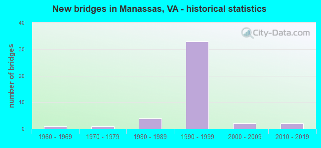
- New bridges - historical statistics
- 11960-1969
- 11970-1979
- 41980-1989
- 331990-1999
- 22000-2009
- 22010-2019


- Bridge Condition - Deck
- 62.5%Good
- 37.5%Satisfactory

- Bridge Condition - Substructure
- 75.0%Good
- 25.0%Satisfactory

- Bridge Condition - Channel
- 18.8%Very good
- 18.8%Good
- 37.5%Satisfactory
- 25.0%Fair

- Bridge Condition - Culverts
- 6.3%Very good
- 50.0%Good
- 43.8%Satisfactory
Find on map >> Show street view
Structure Number: 14279, Location: 00.08FR1004/00.05TO661 (Lat: 38.770056, Lng: -77.494564), Route carried "on" structure: State highway 234, Year Built: 1970, Status: Open, Structure Length: 0.98m (3.22ft), Average Daily Traffic: 21,077 (year 2020), Truck Traffic: 3%, Average Future Daily Traffic: 23,185 (year 2040), Design Load: HS 20, Features Intersected: FLAT BRANCH, Facility Carried by Structure: SUDLEY ROAD
Minimum Vertical Clearance: 30+ m (98+ ft), Kilometerpoint: 5.503, Lanes on structure: 6, Owner: State Highway Agency, Approaching Roadway Width: 18.0m (59.1ft), Material/Design: Concrete, Design/Construction: Culvert, Number Of Spans In Main Unit: 4, Length of Maximum Span: 2.1m (6.9ft)
Condition: Channel: Fair, Culverts: Satisfactory, Operating Rating: 88.9 metric tons, Method Used To Determine Operating Rating: Load Factor (LF), Inventory Rating: 52.6 metric tons, Method Used To Determine Inventory Rating: Load Factor (LF), Structural Evaluation: Equal to present minimum criteria, Waterway Adequacy: Better than present minimum criteria, Approach Roadway Alignment: Equal to present minimum criteria, Designated Inspection Frequency: Every 24 months, Inspection Date: June 2021
Find on map >> Show street view
Structure Number: 22529, Location: 1.05FR674/0.25TO28 S.B. (Lat: 38.747794, Lng: -77.512094), Route carried "on" structure: City street , Year Built: 1964, Status: Open, Structure Length: 0.73m (2.40ft), Average Daily Traffic: 12,471 (year 2020), Truck Traffic: 4%, Average Future Daily Traffic: 17,362 (year 2040), Design Load: HS 20+Mod, Features Intersected: CANNON BR, Facility Carried by Structure: GODWIN DRIVE
Minimum Vertical Clearance: 30+ m (98+ ft), Kilometerpoint: 0.000, Lanes on structure: 2, Owner: City or Municipal Highway Agency, Approaching Roadway Width: 6.7m (22.0ft), Skew: 4 degrees, Material/Design: Concrete, Design/Construction: Culvert, Number Of Spans In Main Unit: 2, Length of Maximum Span: 3.7m (12.1ft)
Condition: Channel: Satisfactory, Culverts: Satisfactory, Operating Rating: 69.9 metric tons, Method Used To Determine Operating Rating: Field evaluation and documented engineering judgment, Inventory Rating: 41.7 metric tons, Method Used To Determine Inventory Rating: Field evaluation and documented engineering judgment, Structural Evaluation: Equal to present minimum criteria, Waterway Adequacy: Better than present minimum criteria, Approach Roadway Alignment: Equal to present minimum criteria, Length Of Structure Improvement: 0.30m (0.98ft), Designated Inspection Frequency: Every 24 months, Inspection Date: July 2021, Bridge Improvement Cost: $1,000, Roadway Improvement Cost: $1,000, Total Project Cost: $10,000 ( Estimate for 2015)
Find on map >> Show street view
Structure Number: 23081, Location: 0.80FR782/0.02TOGODWIN DR (Lat: 38.743872, Lng: -77.513378), Route carried "on" structure: State highway 28, Year Built: 1990, Status: Open, Structure Length: 0.88m (2.89ft), Average Daily Traffic: 34,271 (year 2020), Truck Traffic: 3%, Average Future Daily Traffic: 47,979 (year 2040), Design Load: HS 20+Mod, Features Intersected: CANNON BRANCH, Facility Carried by Structure: NOKESVILLE RD.
Minimum Vertical Clearance: 30+ m (98+ ft), Kilometerpoint: 33.081, Lanes on structure: 6, Base Highway Network: Yes, Owner: City or Municipal Highway Agency, Approaching Roadway Width: 22.6m (74.1ft), Material/Design: Concrete, Design/Construction: Culvert, Number Of Spans In Main Unit: 3, Length of Maximum Span: 2.7m (8.9ft)
Condition: Channel: Good, Culverts: Good, Operating Rating: 72.6 metric tons, Method Used To Determine Operating Rating: Field evaluation and documented engineering judgment, Inventory Rating: 43.5 metric tons, Method Used To Determine Inventory Rating: Field evaluation and documented engineering judgment, Structural Evaluation: Better than present minimum criteria, Waterway Adequacy: Equal to present desirable criteria, Approach Roadway Alignment: Equal to present desirable criteria, Length Of Structure Improvement: 0.30m (0.98ft), Designated Inspection Frequency: Every 24 months, Inspection Date: August 2021, Bridge Improvement Cost: $1,000, Roadway Improvement Cost: $1,000, Total Project Cost: $3,000 ( Estimate for 2015)
Find on map >> Show street view
Structure Number: 24159, Location: 00.01 MI. S. OF HASTINGS (Lat: 38.733214, Lng: -77.474242), Route carried "on" structure: State highway 234, Year Built: 1985, Status: Open, Structure Length: 0.76m (2.49ft), Average Daily Traffic: 7,930 (year 2020), Truck Traffic: 3%, Average Future Daily Traffic: 8,723 (year 2040), Design Load: HS 20+Mod, Features Intersected: COCKRELL BRANCH, Facility Carried by Structure: DUMFRIES ROAD
Minimum Vertical Clearance: 30+ m (98+ ft), Kilometerpoint: 0.000, Lanes on structure: 4, Owner: City or Municipal Highway Agency, Approaching Roadway Width: 6.7m (22.0ft), Material/Design: Concrete, Design/Construction: Culvert, Number Of Spans In Main Unit: 4, Length of Maximum Span: 1.5m (4.9ft)
Condition: Channel: Satisfactory, Culverts: Good, Operating Rating: 68.0 metric tons, Method Used To Determine Operating Rating: Field evaluation and documented engineering judgment, Inventory Rating: 40.8 metric tons, Method Used To Determine Inventory Rating: Field evaluation and documented engineering judgment, Structural Evaluation: Better than present minimum criteria, Waterway Adequacy: Equal to present desirable criteria, Approach Roadway Alignment: Equal to present desirable criteria, Length Of Structure Improvement: 0.30m (0.98ft), Designated Inspection Frequency: Every 24 months, Inspection Date: August 2021, Bridge Improvement Cost: $1,000, Roadway Improvement Cost: $1,000, Total Project Cost: $3,000 ( Estimate for 2015)
Find on map >> Show street view
Structure Number: 24161, Location: 00.01 W OF DUMFRIES RD. (Lat: 38.733333, Lng: -77.474742), Route carried "on" structure: City street , Year Built: 1989, Status: Open, Structure Length: 0.64m (2.10ft), Average Daily Traffic: 4,141 (year 2020), Truck Traffic: 3%, Average Future Daily Traffic: 4,555 (year 2040), Design Load: HS 20+Mod, Features Intersected: COCKRELL BRANCH, Facility Carried by Structure: HASTINGS DRIVE
Minimum Vertical Clearance: 30+ m (98+ ft), Kilometerpoint: 0.000, Lanes on structure: 6, Owner: City or Municipal Highway Agency, Approaching Roadway Width: 23.2m (76.1ft), Skew: 2 degrees, Material/Design: Concrete, Design/Construction: Culvert, Number Of Spans In Main Unit: 2, Length of Maximum Span: 3.0m (9.8ft)
Condition: Channel: Satisfactory, Culverts: Good, Operating Rating: 86.2 metric tons, Method Used To Determine Operating Rating: Field evaluation and documented engineering judgment, Inventory Rating: 51.7 metric tons, Method Used To Determine Inventory Rating: Field evaluation and documented engineering judgment, Structural Evaluation: Better than present minimum criteria, Waterway Adequacy: Equal to present desirable criteria, Approach Roadway Alignment: Equal to present desirable criteria, Length Of Structure Improvement: 0.30m (0.98ft), Designated Inspection Frequency: Every 24 months, Inspection Date: August 2021, Bridge Improvement Cost: $1,000, Roadway Improvement Cost: $1,000, Total Project Cost: $3,000 ( Estimate for 2015)
Find on map >> Show street view
Structure Number: 24162, Location: 00.20 W OF DUMFRIES RD. (Lat: 38.733300, Lng: -77.478253), Route carried "on" structure: City street , Year Built: 1989, Status: Open, Structure Length: 1.40m (4.59ft), Average Daily Traffic: 4,141 (year 2020), Truck Traffic: 3%, Average Future Daily Traffic: 4,555 (year 2040), Design Load: HS 20+Mod, Features Intersected: COCKRELL BRANCH, Facility Carried by Structure: HASTINGS DRIVE
Minimum Vertical Clearance: 30+ m (98+ ft), Kilometerpoint: 0.000, Lanes on structure: 8, Owner: City or Municipal Highway Agency, Approaching Roadway Width: 30.5m (100.1ft), Skew: 4 degrees, Material/Design: Concrete, Design/Construction: Culvert, Number Of Spans In Main Unit: 3, Length of Maximum Span: 4.3m (14.1ft)
Condition: Channel: Very good, Culverts: Satisfactory, Operating Rating: 63.5 metric tons, Method Used To Determine Operating Rating: Field evaluation and documented engineering judgment, Inventory Rating: 38.1 metric tons, Method Used To Determine Inventory Rating: Field evaluation and documented engineering judgment, Structural Evaluation: Equal to present minimum criteria, Waterway Adequacy: Equal to present desirable criteria, Approach Roadway Alignment: Equal to present desirable criteria, Length Of Structure Improvement: 0.30m (0.98ft), Designated Inspection Frequency: Every 24 months, Inspection Date: August 2021, Bridge Improvement Cost: $1,000, Roadway Improvement Cost: $1,000, Total Project Cost: $3,000 ( Estimate for 2015)
Find on map >> Show street view
Structure Number: 24163, Location: 00.12 W OF HASTINGS (Lat: 38.738150, Lng: -77.500872), Route carried "on" structure: City street , Year Built: 1990, Status: Open, Structure Length: 0.64m (2.10ft), Average Daily Traffic: 9,110 (year 2020), Truck Traffic: 2%, Average Future Daily Traffic: 10,021 (year 2040), Design Load: HS 20+Mod, Features Intersected: WINTER BRANCH, Facility Carried by Structure: GODWIN DRIVE
Minimum Vertical Clearance: 30+ m (98+ ft), Kilometerpoint: 0.000, Lanes on structure: 4, Owner: City or Municipal Highway Agency, Approaching Roadway Width: 15.8m (51.8ft), Material/Design: Concrete, Design/Construction: Culvert, Number Of Spans In Main Unit: 2, Length of Maximum Span: 3.0m (9.8ft)
Condition: Channel: Good, Culverts: Satisfactory, Operating Rating: 87.1 metric tons, Method Used To Determine Operating Rating: Field evaluation and documented engineering judgment, Inventory Rating: 51.7 metric tons, Method Used To Determine Inventory Rating: Field evaluation and documented engineering judgment, Structural Evaluation: Equal to present minimum criteria, Waterway Adequacy: Equal to present desirable criteria, Approach Roadway Alignment: Equal to present desirable criteria, Length Of Structure Improvement: 0.30m (0.98ft), Designated Inspection Frequency: Every 24 months, Inspection Date: July 2021, Bridge Improvement Cost: $1,000, Roadway Improvement Cost: $1,000, Total Project Cost: $10,000 ( Estimate for 2015)
Find on map >> Show street view
Structure Number: 24164, Location: 00.05 S OF NOKESVILLE RD. (Lat: 38.743364, Lng: -77.512344), Route carried "on" structure: City street , Year Built: 1990, Status: Open, Structure Length: 1.04m (3.41ft), Average Daily Traffic: 9,110 (year 2020), Truck Traffic: 6%, Average Future Daily Traffic: 10,021 (year 2040), Design Load: HS 20+Mod, Features Intersected: TRIB. OF CANNON BRANCH, Facility Carried by Structure: GODWIN DRIVE
Minimum Vertical Clearance: 30+ m (98+ ft), Kilometerpoint: 0.000, Lanes on structure: 6, Owner: City or Municipal Highway Agency, Approaching Roadway Width: 19.5m (64.0ft), Material/Design: Concrete, Design/Construction: Culvert, Number Of Spans In Main Unit: 3, Length of Maximum Span: 3.0m (9.8ft)
Condition: Channel: Satisfactory, Culverts: Satisfactory, Operating Rating: 65.3 metric tons, Method Used To Determine Operating Rating: Field evaluation and documented engineering judgment, Inventory Rating: 39.0 metric tons, Method Used To Determine Inventory Rating: Field evaluation and documented engineering judgment, Structural Evaluation: Equal to present minimum criteria, Waterway Adequacy: Equal to present desirable criteria, Approach Roadway Alignment: Equal to present desirable criteria, Length Of Structure Improvement: 0.30m (0.98ft), Designated Inspection Frequency: Every 24 months, Inspection Date: July 2021, Bridge Improvement Cost: $1,000, Roadway Improvement Cost: $1,000, Total Project Cost: $3,000 ( Estimate for 2015)
Find on map >> Show street view
Structure Number: 24165, Location: 00.20 E OF PRINCE WM. ST. (Lat: 38.744300, Lng: -77.486383), Route carried "on" structure: City street , Year Built: 1988, Status: Open, Structure Length: 0.70m (2.30ft), Average Daily Traffic: 12,139 (year 2020), Truck Traffic: 1%, Average Future Daily Traffic: 16,115 (year 2040), Design Load: HS 20+Mod, Features Intersected: WINTER BRANCH, Facility Carried by Structure: WELLINGTON ROAD
Minimum Vertical Clearance: 30+ m (98+ ft), Kilometerpoint: 0.000, Lanes on structure: 4, Owner: City or Municipal Highway Agency, Approaching Roadway Width: 15.8m (51.8ft), Skew: 2 degrees, Material/Design: Concrete, Design/Construction: Culvert, Number Of Spans In Main Unit: 2, Length of Maximum Span: 3.4m (11.2ft)
Condition: Channel: Satisfactory, Culverts: Satisfactory, Operating Rating: 68.9 metric tons, Method Used To Determine Operating Rating: Field evaluation and documented engineering judgment, Inventory Rating: 40.8 metric tons, Method Used To Determine Inventory Rating: Field evaluation and documented engineering judgment, Structural Evaluation: Equal to present minimum criteria, Waterway Adequacy: Equal to present desirable criteria, Approach Roadway Alignment: Equal to present desirable criteria, Length Of Structure Improvement: 0.30m (0.98ft), Designated Inspection Frequency: Every 24 months, Inspection Date: July 2021, Bridge Improvement Cost: $1,000, Roadway Improvement Cost: $1,000, Total Project Cost: $3,000 ( Estimate for 2015)
Find on map >> Show street view
Structure Number: 24338, Location: 00.35FR234/00.15TO28 (Lat: 38.741000, Lng: -77.520183), Route carried "on" structure: Ramp State highway 234, Year Built: 1995, Status: Open, Structure Length: 0.64m (2.10ft), Average Daily Traffic: 20,937 (year 2018), Truck Traffic: 8%, Average Future Daily Traffic: 9,000 (year 2033), Design Load: HS 20, Features Intersected: TRIB. OF CANNON BRANCH
Minimum Vertical Clearance: 30+ m (98+ ft), Kilometerpoint: 0.000, Lanes on structure: 1, Base Highway Network: Yes, Owner: State Highway Agency, Approaching Roadway Width: 6.1m (20.0ft), Skew: 4 degrees, Material/Design: Concrete, Design/Construction: Culvert, Number Of Spans In Main Unit: 2, Length of Maximum Span: 2.7m (8.9ft)
Condition: Channel: Fair, Culverts: Good, Operating Rating: 89.8 metric tons, Method Used To Determine Operating Rating: Load Factor (LF), Inventory Rating: 89.7 metric tons, Method Used To Determine Inventory Rating: Load Factor (LF), Structural Evaluation: Better than present minimum criteria, Waterway Adequacy: Equal to present desirable criteria, Approach Roadway Alignment: Equal to present desirable criteria, Length Of Structure Improvement: 6.68m (21.92ft), Designated Inspection Frequency: Every 24 months, Inspection Date: January 2022, Bridge Improvement Cost: $20,000, Roadway Improvement Cost: $20,000, Total Project Cost: $55,000
Find on map >> Show street view
Structure Number: 24379, Location: 00.20FR END/00.05TO VANOR (Lat: 38.732189, Lng: -77.461156), Route carried "on" structure: County highway 2574, Year Built: 1992, Status: Open, Structure Length: 0.91m (2.99ft), Average Daily Traffic: 120 (year 2013), Average Future Daily Traffic: 136 (year 2040), Design Load: HS 20, Features Intersected: TRIB. OF CABIN RUN, Facility Carried by Structure: CABIN RIDGE COURT
Minimum Vertical Clearance: 30+ m (98+ ft), Kilometerpoint: 0.000, Lanes on structure: 2, Owner: State Highway Agency, Approaching Roadway Width: 9.1m (29.9ft), Skew: 3 degrees, Material/Design: Concrete, Design/Construction: Culvert, Number Of Spans In Main Unit: 4, Length of Maximum Span: 2.1m (6.9ft)
Condition: Channel: Fair, Culverts: Good, Operating Rating: 89.8 metric tons, Method Used To Determine Operating Rating: Load Factor (LF), Inventory Rating: 89.7 metric tons, Method Used To Determine Inventory Rating: Load Factor (LF), Structural Evaluation: Better than present minimum criteria, Waterway Adequacy: Equal to present minimum criteria, Approach Roadway Alignment: Better than present minimum criteria, Length Of Structure Improvement: 14.14m (46.39ft), Designated Inspection Frequency: Every 24 months, Inspection Date: January 2022, Bridge Improvement Cost: $25,000, Roadway Improvement Cost: $50,000, Total Project Cost: $100,000
Find on map >> Show street view
Structure Number: 24735, Location: 00.45FR28/00.55TO689 (Lat: 38.757319, Lng: -77.452969), Route carried "on" structure: City street , Year Built: 1996, Status: Open, Structure Length: 2.35m (7.71ft), Average Daily Traffic: 31,098 (year 2020), Truck Traffic: 2%, Average Future Daily Traffic: 43,537 (year 2040), Design Load: HS 20, Features Intersected: NS RAILWAY, Facility Carried by Structure: LIBERIA AVE.
Minimum Vertical Clearance: 30+ m (98+ ft), Kilometerpoint: 0.000, Lanes on structure: 4, Owner: City or Municipal Highway Agency, Approaching Roadway Width: 16.8m (55.1ft), Skew: 20 degrees, Material/Design: Steel, Design/Construction: Stringer/Multi-beam, Number Of Spans In Main Unit: 1, Length of Maximum Span: 23.5m (77.1ft), Curb or Sidewalk Widths: Left: 2.9m (9.5ft), Right: 1.9m (6.2ft), Curb-To-Curb Width: 16.8m (55.1ft), Out-to-Out Width: 27.2m (89.2ft)
Condition: Deck: Good, Superstructure: Good, Substructure: Good, Operating Rating: 71.8 metric tons, Method Used To Determine Operating Rating: Load and Resistance Factor (LRFR), Inventory Rating: 55.3 metric tons, Method Used To Determine Inventory Rating: Load and Resistance Factor (LRFR), Structural Evaluation: Better than present minimum criteria, Deck Geometry: Somewhat better than minimum adequacy, Underclear: Somewhat better than minimum adequacy, Approach Roadway Alignment: Equal to present desirable criteria, Length Of Structure Improvement: 0.30m (0.98ft), Designated Inspection Frequency: Every 24 months, Inspection Date: October 2021, Bridge Improvement Cost: $1,000, Roadway Improvement Cost: $1,000, Total Project Cost: $3,000 ( Estimate for 2015), Deck Structure Type: Concrete Cast-file-Place, Wearing Surface/Protective System: Wearing Surface: Monolithic Concrete, Deck Protection: Epoxy Coated Reinforcing
Find on map >> Show street view
Structure Number: 24747, Location: 00.01FR0000/00.90TO234 (Lat: 38.748925, Lng: -77.511856), Route carried "on" structure: County highway 3100, Year Built: 1996, Status: Open, Structure Length: 0.64m (2.10ft), Average Daily Traffic: 6,448 (year 2020), Truck Traffic: 1%, Average Future Daily Traffic: 7,093 (year 2040), Design Load: HS 20+Mod, Features Intersected: TRIB. CANNON BRANCH, Facility Carried by Structure: UNIVERSITY BLVD
Minimum Vertical Clearance: 30+ m (98+ ft), Kilometerpoint: 0.000, Lanes on structure: 3, Owner: State Highway Agency, Approaching Roadway Width: 11.6m (38.1ft), Material/Design: Concrete, Design/Construction: Culvert, Number Of Spans In Main Unit: 2, Length of Maximum Span: 3.0m (9.8ft)
Condition: Channel: Fair, Culverts: Good, Operating Rating: 89.8 metric tons, Method Used To Determine Operating Rating: Load Factor (LF), Inventory Rating: 70.8 metric tons, Method Used To Determine Inventory Rating: Load Factor (LF), Structural Evaluation: Better than present minimum criteria, Waterway Adequacy: Better than present minimum criteria, Approach Roadway Alignment: Equal to present desirable criteria, Length Of Structure Improvement: 6.04m (19.82ft), Designated Inspection Frequency: Every 24 months, Inspection Date: March 2021, Bridge Improvement Cost: $45,000, Roadway Improvement Cost: $78,000, Total Project Cost: $150,000
Find on map >> Show street view
Structure Number: 24748, Location: 00.20FR0000/00.70TO END (Lat: 38.749756, Lng: -77.514592), Route carried "on" structure: County highway 3100, Year Built: 1996, Status: Open, Structure Length: 1.52m (4.99ft), Average Daily Traffic: 6,448 (year 2020), Truck Traffic: 1%, Average Future Daily Traffic: 7,093 (year 2040), Design Load: HS 20+Mod, Features Intersected: TRIB. CANNON BRANCH, Facility Carried by Structure: UNIVERSITY BLVD.
Minimum Vertical Clearance: 30+ m (98+ ft), Kilometerpoint: 0.000, Lanes on structure: 4, Owner: State Highway Agency, Approaching Roadway Width: 11.6m (38.1ft), Material/Design: Concrete, Design/Construction: Culvert, Number Of Spans In Main Unit: 4, Length of Maximum Span: 3.7m (12.1ft)
Condition: Channel: Satisfactory, Culverts: Good, Operating Rating: 75.3 metric tons, Method Used To Determine Operating Rating: Load Factor (LF), Inventory Rating: 44.5 metric tons, Method Used To Determine Inventory Rating: Load Factor (LF), Structural Evaluation: Better than present minimum criteria, Waterway Adequacy: Better than present minimum criteria, Approach Roadway Alignment: Equal to present desirable criteria, Length Of Structure Improvement: 10.97m (35.99ft), Designated Inspection Frequency: Every 24 months, Inspection Date: March 2021, Bridge Improvement Cost: $54,000, Roadway Improvement Cost: $99,000, Total Project Cost: $175,000
Find on map >> Show street view
Structure Number: 24791, Location: 02.00FR674/00.40TO28 (Lat: 38.741772, Lng: -77.518703), Route carried "on" structure: State highway 234, Year Built: 1997, Status: Open, Structure Length: 5.88m (19.29ft), Average Daily Traffic: 19,521 (year 2020), Truck Traffic: 8%, Average Future Daily Traffic: 27,331 (year 2040), Design Load: HS 20, Features Intersected: RTE. 28 NOKESVILLE RD.
Minimum Vertical Clearance: 30+ m (98+ ft), Kilometerpoint: 29.203, Lanes on structure: 3, Lanes under structure: 6, Base Highway Network: Yes, Owner: State Highway Agency, Approaching Roadway Width: 15.8m (51.8ft), Skew: 1 degrees, Material/Design: Steel continuous, Design/Construction: Stringer/Multi-beam, Number Of Spans In Main Unit: 2, Length of Maximum Span: 29.6m (97.1ft), Curb-To-Curb Width: 15.8m (51.8ft), Out-to-Out Width: 16.6m (54.5ft)
Condition: Deck: Good, Superstructure: Good, Substructure: Good, Operating Rating: 59.1 metric tons, Method Used To Determine Operating Rating: Load and Resistance Factor (LRFR), Inventory Rating: 45.6 metric tons, Method Used To Determine Inventory Rating: Load and Resistance Factor (LRFR), Structural Evaluation: Better than present minimum criteria, Deck Geometry: Better than present minimum criteria, Underclear: Meets minimum limits, Approach Roadway Alignment: Equal to present desirable criteria, Length Of Structure Improvement: 5.88m (19.29ft), Designated Inspection Frequency: Every 24 months, Inspection Date: September 2021, Bridge Improvement Cost: $25,000, Roadway Improvement Cost: $50,000, Total Project Cost: $100,000, Deck Structure Type: Concrete Cast-file-Place, Wearing Surface/Protective System: Wearing Surface: Monolithic Concrete, Deck Protection: Epoxy Coated Reinforcing
Find on map >> Show street view
Structure Number: 24792, Location: 00.30FR28/00.40TO234 (Lat: 38.741350, Lng: -77.520317), Route carried "on" structure: Ramp State highway 234, Year Built: 1997, Status: Open, Structure Length: 25.76m (84.51ft), Average Daily Traffic: 17,236 (year 2018), Truck Traffic: 3%, Average Future Daily Traffic: 5,000 (year 2033), Design Load: HS 20, Features Intersected: ROUTES 28 & 234
Minimum Vertical Clearance: 30+ m (98+ ft), Kilometerpoint: 0.000, Lanes on structure: 1, Lanes under structure: 9, Base Highway Network: Yes, Owner: State Highway Agency, Approaching Roadway Width: 9.1m (29.9ft), Skew: 9 degrees, Material/Design: Steel continuous, Design/Construction: Stringer/Multi-beam, Number Of Spans In Main Unit: 5, Length of Maximum Span: 74.7m (245.1ft), Curb-To-Curb Width: 9.1m (29.9ft), Out-to-Out Width: 10.2m (33.5ft)
Condition: Deck: Good, Superstructure: Good, Substructure: Satisfactory, Operating Rating: 82.6 metric tons, Method Used To Determine Operating Rating: Load and Resistance Factor (LRFR), Inventory Rating: 63.5 metric tons, Method Used To Determine Inventory Rating: Load and Resistance Factor (LRFR), Structural Evaluation: Equal to present minimum criteria, Deck Geometry: Superior to present desirable criteria, Underclear: Equal to present minimum criteria, Approach Roadway Alignment: Equal to present desirable criteria, Length Of Structure Improvement: 25.76m (84.51ft), Designated Inspection Frequency: Every 24 months, Inspection Date: October 2021, Bridge Improvement Cost: $68,000, Roadway Improvement Cost: $100,000, Total Project Cost: $175,000, Deck Structure Type: Concrete Cast-file-Place, Wearing Surface/Protective System: Wearing Surface: Monolithic Concrete, Deck Protection: Epoxy Coated Reinforcing
Find on map >> Show street view
Structure Number: 25747, Location: 00.08FR28/00.10TO234 (Lat: 38.742944, Lng: -77.517194), Route carried "on" structure: Ramp State highway 28, Year Built: 1999, Status: Open, Structure Length: 30.45m (99.90ft), Average Daily Traffic: 17,236 (year 2018), Truck Traffic: 3%, Average Future Daily Traffic: 38,000 (year 2033), Design Load: HS 20, Features Intersected: RTE.28 & RTE.234 BYPASS, Facility Carried by Structure: RAMP A FR NOKSVL
Minimum Vertical Clearance: 30+ m (98+ ft), Kilometerpoint: 33.499, Lanes on structure: 1, Lanes under structure: 10, Base Highway Network: Yes, Owner: State Highway Agency, Approaching Roadway Width: 8.5m (27.9ft), Skew: 8 degrees, Material/Design: Steel continuous, Design/Construction: Stringer/Multi-beam, Number Of Spans In Main Unit: 7, Length of Maximum Span: 48.8m (160.1ft), Curb-To-Curb Width: 8.5m (27.9ft), Out-to-Out Width: 9.5m (31.2ft)
Condition: Deck: Good, Superstructure: Good, Substructure: Satisfactory, Operating Rating: 67.1 metric tons, Method Used To Determine Operating Rating: Load and Resistance Factor (LRFR), Inventory Rating: 51.7 metric tons, Method Used To Determine Inventory Rating: Load and Resistance Factor (LRFR), Structural Evaluation: Equal to present minimum criteria, Deck Geometry: Superior to present desirable criteria, Approach Roadway Alignment: Equal to present minimum criteria, Length Of Structure Improvement: 30.45m (99.90ft), Designated Inspection Frequency: Every 24 months, Inspection Date: October 2021, Bridge Improvement Cost: $65,000, Roadway Improvement Cost: $79,000, Total Project Cost: $175,000, Deck Structure Type: Concrete Cast-file-Place, Wearing Surface/Protective System: Wearing Surface: Monolithic Concrete, Deck Protection: Epoxy Coated Reinforcing
Find on map >> Show street view
Structure Number: 25748, Location: 00.38FR28/01.40TO3235 (Lat: 38.738325, Lng: -77.515042), Route carried "on" structure: Ramp State highway 28, Year Built: 1999, Status: Open, Structure Length: 6.19m (20.31ft), Average Daily Traffic: 20,937 (year 2018), Truck Traffic: 8%, Average Future Daily Traffic: 5,000 (year 2032), Design Load: HS 20, Features Intersected: GATEWAY BLVD
Minimum Vertical Clearance: 30+ m (98+ ft), Kilometerpoint: 0.000, Lanes on structure: 2, Lanes under structure: 4, Owner: State Highway Agency, Approaching Roadway Width: 12.2m (40.0ft), Skew: 2 degrees, Material/Design: Steel continuous, Design/Construction: Stringer/Multi-beam, Number Of Spans In Main Unit: 2, Length of Maximum Span: 37.5m (123.0ft), Curb-To-Curb Width: 11.6m (38.1ft), Out-to-Out Width: 12.6m (41.3ft)
Condition: Deck: Satisfactory, Superstructure: Good, Substructure: Good, Operating Rating: 60.6 metric tons, Method Used To Determine Operating Rating: Load and Resistance Factor (LRFR), Inventory Rating: 46.7 metric tons, Method Used To Determine Inventory Rating: Load and Resistance Factor (LRFR), Structural Evaluation: Better than present minimum criteria, Deck Geometry: Superior to present desirable criteria, Underclear: High priority of corrective action, Approach Roadway Alignment: Equal to present desirable criteria, Length Of Structure Improvement: 6.19m (20.31ft), Designated Inspection Frequency: Every 24 months, Inspection Date: September 2021, Bridge Improvement Cost: $57,000, Roadway Improvement Cost: $89,000, Total Project Cost: $167,000, Deck Structure Type: Concrete Cast-file-Place, Wearing Surface/Protective System: Wearing Surface: Monolithic Concrete, Deck Protection: Epoxy Coated Reinforcing
Find on map >> Show street view
Structure Number: 25749, Location: 1.5FR3235/0.3TO28 (Lat: 38.738967, Lng: -77.515283), Route carried "on" structure: Bypass State highway 234, Year Built: 1999, Status: Open, Structure Length: 5.30m (17.39ft), Average Daily Traffic: 19,521 (year 2020), Truck Traffic: 8%, Average Future Daily Traffic: 27,331 (year 2040), Design Load: HS 20, Features Intersected: GATEWAY BLVD.
Minimum Vertical Clearance: 30.18m (99.02ft), Kilometerpoint: 0.000, Lanes on structure: 3, Lanes under structure: 4, Base Highway Network: Yes, Owner: State Highway Agency, Approaching Roadway Width: 15.2m (49.9ft), Skew: 1 degrees, Material/Design: Steel continuous, Design/Construction: Stringer/Multi-beam, Number Of Spans In Main Unit: 2, Length of Maximum Span: 28.3m (92.8ft), Curb-To-Curb Width: 16.2m (53.1ft), Out-to-Out Width: 16.9m (55.4ft)
Condition: Deck: Satisfactory, Superstructure: Good, Substructure: Good, Operating Rating: 51.2 metric tons, Method Used To Determine Operating Rating: Load and Resistance Factor (LRFR), Inventory Rating: 39.5 metric tons, Method Used To Determine Inventory Rating: Load and Resistance Factor (LRFR), Structural Evaluation: Better than present minimum criteria, Deck Geometry: Equal to present minimum criteria, Underclear: High priority of corrective action, Approach Roadway Alignment: Equal to present desirable criteria, Length Of Structure Improvement: 0.30m (0.98ft), Designated Inspection Frequency: Every 24 months, Inspection Date: September 2021, Bridge Improvement Cost: $1,000, Roadway Improvement Cost: $1,000, Total Project Cost: $3,000, Deck Structure Type: Concrete Cast-file-Place, Wearing Surface/Protective System: Wearing Surface: Monolithic Concrete, Deck Protection: Epoxy Coated Reinforcing
Find on map >> Show street view
Structure Number: 2575, Location: 0.38FR28/1.40TO3235 (Lat: 38.738458, Lng: -77.514953), Route carried "on" structure: Bypass State highway 234, Year Built: 1999, Status: Open, Structure Length: 4.69m (15.39ft), Average Daily Traffic: 19,521 (year 2020), Truck Traffic: 8%, Average Future Daily Traffic: 27,331 (year 2040), Design Load: HS 20, Features Intersected: GATEWAY BLVD
Minimum Vertical Clearance: 30+ m (98+ ft), Kilometerpoint: 0.000, Lanes on structure: 2, Lanes under structure: 4, Owner: State Highway Agency, Approaching Roadway Width: 15.8m (51.8ft), Skew: 2 degrees, Material/Design: Steel, Design/Construction: Stringer/Multi-beam, Number Of Spans In Main Unit: 2, Length of Maximum Span: 46.9m (153.9ft), Curb-To-Curb Width: 12.2m (40.0ft), Out-to-Out Width: 13.2m (43.3ft)
Condition: Deck: Satisfactory, Superstructure: Good, Substructure: Good, Operating Rating: 89.8 metric tons, Method Used To Determine Operating Rating: Load and Resistance Factor (LRFR), Inventory Rating: 79.2 metric tons, Method Used To Determine Inventory Rating: Load and Resistance Factor (LRFR), Structural Evaluation: Better than present minimum criteria, Deck Geometry: Better than present minimum criteria, Underclear: High priority of corrective action, Approach Roadway Alignment: Equal to present desirable criteria, Designated Inspection Frequency: Every 24 months, Inspection Date: September 2021, Deck Structure Type: Concrete Cast-file-Place, Wearing Surface/Protective System: Wearing Surface: Monolithic Concrete, Deck Protection: Epoxy Coated Reinforcing
Find on map >> Show street view
Structure Number: 25751, Location: 01.70FRCLOVER/02.20TO674 (Lat: 38.741900, Lng: -77.518500), Route carried "on" structure: State highway 234, Year Built: 1999, Status: Open, Structure Length: 5.85m (19.19ft), Average Daily Traffic: 19,521 (year 2020), Truck Traffic: 8%, Average Future Daily Traffic: 27,331 (year 2040), Design Load: HS 20, Features Intersected: RTE.28 NOKESVILLE RD.
Minimum Vertical Clearance: 30+ m (98+ ft), Kilometerpoint: 29.203, Lanes on structure: 3, Lanes under structure: 6, Base Highway Network: Yes, Owner: State Highway Agency, Approaching Roadway Width: 16.5m (54.1ft), Skew: 1 degrees, Material/Design: Steel continuous, Design/Construction: Stringer/Multi-beam, Number Of Spans In Main Unit: 2, Length of Maximum Span: 29.3m (96.1ft), Curb-To-Curb Width: 15.8m (51.8ft), Out-to-Out Width: 16.9m (55.4ft)
Condition: Deck: Good, Superstructure: Good, Substructure: Good, Operating Rating: 49.0 metric tons, Method Used To Determine Operating Rating: Load and Resistance Factor (LRFR), Inventory Rating: 37.8 metric tons, Method Used To Determine Inventory Rating: Load and Resistance Factor (LRFR), Structural Evaluation: Better than present minimum criteria, Deck Geometry: Somewhat better than minimum adequacy, Underclear: Somewhat better than minimum adequacy, Approach Roadway Alignment: Equal to present desirable criteria, Length Of Structure Improvement: 5.85m (19.19ft), Designated Inspection Frequency: Every 24 months, Inspection Date: September 2021, Bridge Improvement Cost: $231,000, Roadway Improvement Cost: $23,000, Total Project Cost: $255,000, Deck Structure Type: Concrete Cast-file-Place, Wearing Surface/Protective System: Wearing Surface: Monolithic Concrete, Deck Protection: Epoxy Coated Reinforcing
Find on map >> Show street view
Structure Number: 25899, Location: .20 FR 234NB & .30 TO 28 (Lat: 38.741147, Lng: -77.516206), Route carried "on" structure: Ramp State highway 234, Year Built: 2000, Status: Open, Structure Length: 0.61m (2.00ft), Average Daily Traffic: 20,937 (year 2018), Truck Traffic: 8%, Average Future Daily Traffic: 9,000 (year 2033), Design Load: HS 20, Features Intersected: TRIB. OF CANNON BRANCH
Minimum Vertical Clearance: 30+ m (98+ ft), Kilometerpoint: 0.000, Lanes on structure: 1, Base Highway Network: Yes, Owner: State Highway Agency, Approaching Roadway Width: 10.1m (33.1ft), Material/Design: Concrete, Design/Construction: Culvert, Number Of Spans In Main Unit: 3, Length of Maximum Span: 1.8m (5.9ft)
Condition: Channel: Good, Culverts: Good, Operating Rating: 89.8 metric tons, Method Used To Determine Operating Rating: Load Factor (LF), Inventory Rating: 89.7 metric tons, Method Used To Determine Inventory Rating: Load Factor (LF), Structural Evaluation: Better than present minimum criteria, Waterway Adequacy: Equal to present desirable criteria, Approach Roadway Alignment: Equal to present desirable criteria, Length Of Structure Improvement: 9.24m (30.31ft), Designated Inspection Frequency: Every 24 months, Inspection Date: March 2020, Bridge Improvement Cost: $50,000, Roadway Improvement Cost: $100,000, Total Project Cost: $200,000
Find on map >> Show street view
Structure Number: 27622, Location: 00.03 FROM GAITHER ST. (Lat: 38.776236, Lng: -77.477822), Route carried "on" structure: City street , Year Built: 2001, Status: Open, Structure Length: 1.04m (3.41ft), Average Daily Traffic: 1,000 (year 2003), Truck Traffic: 3%, Average Future Daily Traffic: 1,500 (year 2034), Design Load: HS 20, Features Intersected: FLAT BRANCH TRIB., Facility Carried by Structure: SUMNER LAKE BLVD.
Minimum Vertical Clearance: 30+ m (98+ ft), Kilometerpoint: 0.000, Lanes on structure: 2, Owner: City or Municipal Highway Agency, Approaching Roadway Width: 11.6m (38.1ft), Material/Design: Concrete, Design/Construction: Culvert, Number Of Spans In Main Unit: 3, Length of Maximum Span: 3.0m (9.8ft)
Condition: Channel: Very good, Culverts: Satisfactory, Operating Rating: 89.8 metric tons, Method Used To Determine Operating Rating: Load Factor (LF), Inventory Rating: 89.8 metric tons, Method Used To Determine Inventory Rating: Load Factor (LF), Structural Evaluation: Equal to present minimum criteria, Waterway Adequacy: Equal to present desirable criteria, Approach Roadway Alignment: Equal to present desirable criteria, Length Of Structure Improvement: 0.30m (0.98ft), Designated Inspection Frequency: Every 24 months, Inspection Date: Febuary 2022, Bridge Improvement Cost: $1,000, Roadway Improvement Cost: $1,000, Total Project Cost: $3,000 ( Estimate for 2016)
Find on map >> Show street view
Structure Number: 31281, Location: 00.02fr3248 00.25to660 (Lat: 38.743911, Lng: -77.527131), Route carried "on" structure: Alternate County highway 2019, Year Built: 2019, Status: Open, Structure Length: 0.94m (3.08ft), Average Daily Traffic: 900 (year 2021), Average Future Daily Traffic: 1,500 (year 2035), Design Load: HL 93, Features Intersected: Trib. Broad Run, Facility Carried by Structure: Thomasson Barn rd.
Minimum Vertical Clearance: 30.18m (99.02ft), Kilometerpoint: 0.000, Lanes on structure: 2, Owner: State Highway Agency, Approaching Roadway Width: 15.2m (49.9ft), Material/Design: Concrete, Design/Construction: Culvert, Number Of Spans In Main Unit: 3, Length of Maximum Span: 3.0m (9.8ft), Curb or Sidewalk Widths: Left: 1.5m (4.9ft), Right: 1.5m (4.9ft)
Condition: Channel: Very good, Culverts: Very good, Operating Rating: 54.4 metric tons, Method Used To Determine Operating Rating: Load Factor (LF), Inventory Rating: 32.7 metric tons, Method Used To Determine Inventory Rating: Load Factor (LF), Structural Evaluation: Equal to present desirable criteria, Waterway Adequacy: Superior to present desirable criteria, Approach Roadway Alignment: Equal to present desirable criteria, Designated Inspection Frequency: Every 24 months, Inspection Date: June 2021
Find on map >> Show street view
Structure Number: 24791, Location: 02.00FR674/00.40TO28 (Lat: 38.741772, Lng: -77.518703), Route carried "under" structure: State highway 28, Year Built: 1997, Structure Length: 0. m, Average Daily Traffic: 9,500 (year 1994), Truck Traffic: 3%, Features Intersected: RTE. 28 NOKESVILLE RD., Facility Carried by Structure: 234 EBL
Minimum Vertical Clearance: 5.16m (16.93ft), Kilometerpoint: 0.000, Lanes on structure: 3, Lanes under structure: 3, Material/Design: Steel continuous, Design/Construction: Stringer/Multi-beam, Length of Maximum Span: 29.6m (97.1ft)
Find on map >> Show street view
Structure Number: 24791, Location: 02.00FR674/00.40TO28 (Lat: 38.741772, Lng: -77.518703), Route carried "under" structure: State highway 28, Year Built: 1997, Structure Length: 0. m, Average Daily Traffic: 9,500 (year 1994), Truck Traffic: 3%, Features Intersected: RTE. 28 NOKESVILLE RD., Facility Carried by Structure: 234 EBL
Minimum Vertical Clearance: 5.39m (17.68ft), Kilometerpoint: 0.000, Lanes on structure: 3, Lanes under structure: 3, Material/Design: Steel continuous, Design/Construction: Stringer/Multi-beam, Length of Maximum Span: 29.6m (97.1ft)
Find on map >> Show street view
Structure Number: 24792, Location: 00.30FR28/00.40TO234 (Lat: 38.741350, Lng: -77.520317), Route carried "under" structure: State highway 28, Year Built: 1997, Structure Length: 0. m, Average Daily Traffic: 9,500 (year 1994), Features Intersected: ROUTES 28 & 234, Facility Carried by Structure: 234 CONNECTOR C
Minimum Vertical Clearance: 8.10m (26.57ft), Kilometerpoint: 0.000, Lanes on structure: 1, Lanes under structure: 2, Material/Design: Steel continuous, Design/Construction: Stringer/Multi-beam, Length of Maximum Span: 74.7m (245.1ft)
Find on map >> Show street view
Structure Number: 24792, Location: 00.30FR28/00.40TO234 (Lat: 38.741350, Lng: -77.520317), Route carried "under" structure: State highway 28, Year Built: 1997, Structure Length: 0. m, Average Daily Traffic: 9,500 (year 1994), Features Intersected: ROUTES 28 & 234, Facility Carried by Structure: 234 CONNECTOR C
Minimum Vertical Clearance: 9.07m (29.76ft), Kilometerpoint: 0.000, Lanes on structure: 1, Lanes under structure: 2, Material/Design: Steel continuous, Design/Construction: Stringer/Multi-beam, Length of Maximum Span: 74.7m (245.1ft)
Find on map >> Show street view
Structure Number: 24792, Location: 00.30FR28/00.40TO234 (Lat: 38.741350, Lng: -77.520317), Route carried "under" structure: State highway 234, Year Built: 1997, Structure Length: 0. m, Average Daily Traffic: 3,000 (year 2001), Features Intersected: ROUTES 28 & 234
Minimum Vertical Clearance: 5.41m (17.75ft), Kilometerpoint: 0.000, Lanes on structure: 1, Lanes under structure: 3, Material/Design: Steel continuous, Design/Construction: Stringer/Multi-beam, Length of Maximum Span: 74.7m (245.1ft)
Find on map >> Show street view
Structure Number: 24792, Location: 00.30FR28/00.40TO234 (Lat: 38.741350, Lng: -77.520317), Route carried "under" structure: State highway 234, Year Built: 1997, Structure Length: 0. m, Average Daily Traffic: 3,000 (year 1994), Features Intersected: ROUTES 28 & 234
Minimum Vertical Clearance: 5.36m (17.59ft), Kilometerpoint: 0.000, Lanes on structure: 1, Lanes under structure: 2, Material/Design: Steel continuous, Design/Construction: Stringer/Multi-beam, Length of Maximum Span: 74.7m (245.1ft)
Find on map >> Show street view
Structure Number: 25747, Location: 00.08FR28/00.10TO234 (Lat: 38.742944, Lng: -77.517194), Route carried "under" structure: Bypass US 234, Year Built: 1999, Structure Length: 0. m, Average Daily Traffic: 1,000 (year 2008), Features Intersected: RTE.28 & RTE.234 BYPASS, Facility Carried by Structure: RAMP A FR NOKSVL
Minimum Vertical Clearance: 5.61m (18.41ft), Kilometerpoint: 0.000, Lanes on structure: 1, Lanes under structure: 3, Material/Design: Steel continuous, Design/Construction: Stringer/Multi-beam, Length of Maximum Span: 48.8m (160.1ft)
Find on map >> Show street view
Structure Number: 25747, Location: 00.08FR28/00.10TO234 (Lat: 38.742944, Lng: -77.517194), Route carried "under" structure: Bypass State highway 234, Year Built: 1999, Structure Length: 0. m, Average Daily Traffic: 1,000 (year 2008), Features Intersected: RTE.28 & RTE.234 BYPASS, Facility Carried by Structure: RAMP A FR NOKSVL
Minimum Vertical Clearance: 5.49m (18.01ft), Kilometerpoint: 0.000, Lanes on structure: 1, Lanes under structure: 2, Material/Design: Steel continuous, Design/Construction: Stringer/Multi-beam, Length of Maximum Span: 48.8m (160.1ft)
Find on map >> Show street view
Structure Number: 25747, Location: 00.08FR28/00.10TO234 (Lat: 38.742944, Lng: -77.517194), Route carried "under" structure: US 28, Year Built: 1999, Structure Length: 0. m, Average Daily Traffic: 30,000 (year 2008), Features Intersected: RTE.28 & RTE.234 BYPASS, Facility Carried by Structure: RAMP A FR NOKSVL
Minimum Vertical Clearance: 8.13m (26.67ft), Kilometerpoint: 0.000, Lanes on structure: 1, Lanes under structure: 2, Material/Design: Steel continuous, Design/Construction: Stringer/Multi-beam, Length of Maximum Span: 48.8m (160.1ft)
Find on map >> Show street view
Structure Number: 25747, Location: 00.08FR28/00.10TO234 (Lat: 38.742944, Lng: -77.517194), Route carried "under" structure: US 28, Year Built: 1999, Structure Length: 0. m, Average Daily Traffic: 28,000 (year 2008), Truck Traffic: 1%, Features Intersected: RTE.28 & RTE.234 BYPASS, Facility Carried by Structure: RAMP A FR NOKSVL
Minimum Vertical Clearance: 9.07m (29.76ft), Kilometerpoint: 0.000, Lanes on structure: 1, Lanes under structure: 3, Material/Design: Steel continuous, Design/Construction: Stringer/Multi-beam, Length of Maximum Span: 48.8m (160.1ft)
Find on map >> Show street view
Structure Number: 25748, Location: 00.38FR28/01.40TO3235 (Lat: 38.738325, Lng: -77.515042), Route carried "under" structure: Business County highway , Year Built: 1999, Structure Length: 0. m, Average Daily Traffic: 500 (year 2001), Truck Traffic: 1%, Features Intersected: GATEWAY BLVD, Facility Carried by Structure: RTE. 28 RAMP C
Minimum Vertical Clearance: 5.89m (19.32ft), Kilometerpoint: 0.000, Lanes on structure: 2, Lanes under structure: 2, Material/Design: Steel continuous, Design/Construction: Stringer/Multi-beam, Length of Maximum Span: 37.5m (123.0ft)
Find on map >> Show street view
Structure Number: 25748, Location: 00.38FR28/01.40TO3235 (Lat: 38.738325, Lng: -77.515042), Route carried "under" structure: Business County highway , Year Built: 1999, Structure Length: 0. m, Average Daily Traffic: 500 (year 2001), Truck Traffic: 1%, Features Intersected: GATEWAY BLVD, Facility Carried by Structure: RTE. 28 RAMP C
Minimum Vertical Clearance: 5.64m (18.50ft), Kilometerpoint: 0.000, Lanes on structure: 2, Lanes under structure: 2, Material/Design: Steel continuous, Design/Construction: Stringer/Multi-beam, Length of Maximum Span: 37.5m (123.0ft)
Find on map >> Show street view
Structure Number: 25749, Location: 1.5FR3235/0.3TO28 (Lat: 38.738967, Lng: -77.515283), Route carried "under" structure: Business County highway , Year Built: 1999, Structure Length: 0. m, Average Daily Traffic: 500 (year 2001), Truck Traffic: 1%, Features Intersected: GATEWAY BLVD., Facility Carried by Structure: RTE.234 NBL
Minimum Vertical Clearance: 5.16m (16.93ft), Kilometerpoint: 0.000, Lanes on structure: 3, Lanes under structure: 2, Material/Design: Steel continuous, Design/Construction: Stringer/Multi-beam, Length of Maximum Span: 28.3m (92.8ft)
Find on map >> Show street view
Structure Number: 25749, Location: 1.5FR3235/0.3TO28 (Lat: 38.738967, Lng: -77.515283), Route carried "under" structure: Business County highway , Year Built: 1999, Structure Length: 0. m, Average Daily Traffic: 500 (year 2000), Features Intersected: GATEWAY BLVD., Facility Carried by Structure: RTE.234 NBL
Minimum Vertical Clearance: 5.49m (18.01ft), Kilometerpoint: 0.000, Lanes on structure: 3, Lanes under structure: 2, Material/Design: Steel continuous, Design/Construction: Stringer/Multi-beam, Length of Maximum Span: 28.3m (92.8ft)
Find on map >> Show street view
Structure Number: 2575, Location: 0.38FR28/1.40TO3235 (Lat: 38.738458, Lng: -77.514953), Route carried "under" structure: Business County highway , Year Built: 1999, Structure Length: 0. m, Average Daily Traffic: 500 (year 2001), Truck Traffic: 1%, Features Intersected: GATEWAY BLVD, Facility Carried by Structure: RTE. 234 SBL
Minimum Vertical Clearance: 5.41m (17.75ft), Kilometerpoint: 0.000, Lanes on structure: 2, Lanes under structure: 2, Material/Design: Steel, Design/Construction: Stringer/Multi-beam, Length of Maximum Span: 46.9m (153.9ft)
Find on map >> Show street view
Structure Number: 2575, Location: 0.38FR28/1.40TO3235 (Lat: 38.738458, Lng: -77.514953), Route carried "under" structure: Business County highway , Year Built: 1999, Structure Length: 0. m, Average Daily Traffic: 500 (year 2001), Truck Traffic: 1%, Features Intersected: GATEWAY BLVD, Facility Carried by Structure: RTE. 234 SBL
Minimum Vertical Clearance: 5.82m (19.09ft), Kilometerpoint: 0.000, Lanes on structure: 2, Lanes under structure: 2, Material/Design: Steel, Design/Construction: Stringer/Multi-beam, Length of Maximum Span: 46.9m (153.9ft)
Find on map >> Show street view
Structure Number: 25751, Location: 01.70FRCLOVER/02.20TO674 (Lat: 38.741900, Lng: -77.518500), Route carried "under" structure: US 28, Year Built: 1999, Structure Length: 0. m, Average Daily Traffic: 30,500 (year 2001), Features Intersected: RTE.28 NOKESVILLE RD., Facility Carried by Structure: RTE. 234 NBL
Minimum Vertical Clearance: 5.54m (18.18ft), Kilometerpoint: 0.000, Lanes on structure: 3, Lanes under structure: 3, Material/Design: Steel continuous, Design/Construction: Stringer/Multi-beam, Length of Maximum Span: 29.3m (96.1ft)
Find on map >> Show street view
Structure Number: 25751, Location: 01.70FRCLOVER/02.20TO674 (Lat: 38.741900, Lng: -77.518500), Route carried "under" structure: US 28, Year Built: 1999, Structure Length: 0. m, Average Daily Traffic: 35,000 (year 2001), Truck Traffic: 5%, Features Intersected: RTE.28 NOKESVILLE RD., Facility Carried by Structure: RTE. 234 NBL
Minimum Vertical Clearance: 5.31m (17.42ft), Kilometerpoint: 0.000, Lanes on structure: 3, Lanes under structure: 3, Material/Design: Steel continuous, Design/Construction: Stringer/Multi-beam, Length of Maximum Span: 29.3m (96.1ft)
Find on map >> Show street view
Structure Number: 28987, Location: 01.18 Godwin 01.00 234 (Lat: 38.751689, Lng: -77.493083), Route carried "under" structure: Alternate City street 674, Year Built: 2012, Structure Length: 0. m, Average Daily Traffic: 50,000 (year 2012), Truck Traffic: 5%, Features Intersected: WELLINGTON & RAILROAD, Facility Carried by Structure: 28 NOKEVILLE RD.
Minimum Vertical Clearance: 9.88m (32.41ft), Kilometerpoint: 0.000, Lanes on structure: 4, Lanes under structure: 4, Material/Design: Steel continuous, Design/Construction: Stringer/Multi-beam, Length of Maximum Span: 39.0m (128.0ft)