Bridge Statistics for Melville, New York (NY)
Condition, Traffic, Stress, Structural Evaluation, Project Costs
- National Bridge Inventory (NBI) Statistics
- 27Number of bridges
- 226ft / 69.0mTotal length
- $92,455,000Total costs
- 1,746,478Total average daily traffic
- 24,156Total average daily truck traffic
- National Bridge Inventory (NBI) Registered Bridges for Melville
- No street view available for this location
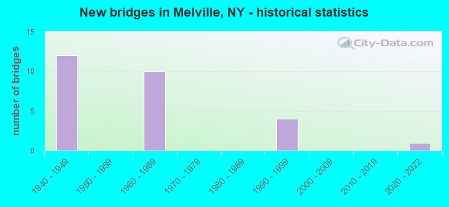
- New bridges - historical statistics
- 121940-1949
- 101960-1969
- 41990-1999
- 12020-2022


- Bridge Condition - Deck
- 7.7%Excellent
- 38.5%Good
- 53.8%Satisfactory

- Bridge Condition - Superstructure
- 7.1%Excellent
- 50.0%Good
- 35.7%Satisfactory
- 7.1%Fair

- Bridge Condition - Substructure
- 7.1%Excellent
- 7.1%Very good
- 42.9%Good
- 42.9%Satisfactory
Find on map >> Show street view
Structure Number: 1036981, Location: JCT I495 & SH 110 (Lat: 40.781006, Lng: -73.418708), Route carried "on" structure: State highway 110, Year Built: 1962, Year Reconstructed: 2011, Status: Open, Structure Length: 8.23m (27.00ft), Average Daily Traffic: 19,431 (year 2020), Truck Traffic: 8%, Average Future Daily Traffic: 22,419 (year 2040), Design Load: HS 20, Features Intersected: 495I 495I 07031014, E/B,
Minimum Vertical Clearance: 30+ m (98+ ft), Kilometerpoint: 12.486, Lanes on structure: 4, Lanes under structure: 10, Base Highway Network: Yes, Owner: State Highway Agency, Approaching Roadway Width: 17.7m (58.1ft), Skew: 2 degrees, Material/Design: Steel, Design/Construction: Stringer/Multi-beam, Number Of Spans In Main Unit: 4, Length of Maximum Span: 27.5m (90.2ft), Curb or Sidewalk Widths: Left: 1.6m (5.2ft), Right: 0.0m, Curb-To-Curb Width: 17.7m (58.1ft), Out-to-Out Width: 20.5m (67.3ft)
Condition: Deck: Satisfactory, Superstructure: Good, Substructure: Satisfactory, Operating Rating: 71.7 metric tons, Method Used To Determine Operating Rating: Field evaluation and documented engineering judgment, Inventory Rating: 42.6 metric tons, Method Used To Determine Inventory Rating: Field evaluation and documented engineering judgment, Structural Evaluation: Equal to present minimum criteria, Deck Geometry: Somewhat better than minimum adequacy, Underclear: High priority of corrective action, Approach Roadway Alignment: Better than present minimum criteria, Length Of Structure Improvement: 8.22m (26.97ft), Designated Inspection Frequency: Every 24 months, Inspection Date: January 2020, Bridge Improvement Cost: $6,343,000, Roadway Improvement Cost: $3,714,000, Total Project Cost: $10,057,000 ( Estimate for 2021), Deck Structure Type: Concrete Cast-file-Place, Wearing Surface/Protective System: Wearing Surface: Monolithic Concrete
Find on map >> Show street view
Structure Number: 1036982, Location: JCT I495 & SH 110 (Lat: 40.780736, Lng: -73.418581), Route carried "on" structure: State highway 110, Year Built: 1962, Year Reconstructed: 2011, Status: Open, Structure Length: 8.23m (27.00ft), Average Daily Traffic: 19,431 (year 2020), Truck Traffic: 8%, Average Future Daily Traffic: 22,419 (year 2040), Design Load: HS 20, Features Intersected: 495I495I07031014, W/B, R
Minimum Vertical Clearance: 30+ m (98+ ft), Kilometerpoint: 12.486, Lanes on structure: 4, Lanes under structure: 10, Base Highway Network: Yes, Owner: State Highway Agency, Approaching Roadway Width: 17.7m (58.1ft), Skew: 2 degrees, Material/Design: Steel, Design/Construction: Stringer/Multi-beam, Number Of Spans In Main Unit: 4, Length of Maximum Span: 27.5m (90.2ft), Curb or Sidewalk Widths: Left: 0.0m, Right: 1.6m (5.2ft), Curb-To-Curb Width: 17.7m (58.1ft), Out-to-Out Width: 20.5m (67.3ft)
Condition: Deck: Satisfactory, Superstructure: Satisfactory, Substructure: Satisfactory, Operating Rating: 50.5 metric tons, Method Used To Determine Operating Rating: Load and Resistance Factor Rating (LRFR) rating reported by rating factor(RF) method using HL-93 loadings, Inventory Rating: 38.9 metric tons, Method Used To Determine Inventory Rating: Load and Resistance Factor Rating (LRFR) rating reported by rating factor(RF) method using HL-93 loadings, Structural Evaluation: Equal to present minimum criteria, Deck Geometry: Somewhat better than minimum adequacy, Underclear: High priority of corrective action, Approach Roadway Alignment: Better than present minimum criteria, Length Of Structure Improvement: 8.22m (26.97ft), Designated Inspection Frequency: Every 24 months, Inspection Date: January 2020, Bridge Improvement Cost: $6,343,000, Roadway Improvement Cost: $3,714,000, Total Project Cost: $10,057,000 ( Estimate for 2021), Deck Structure Type: Concrete Cast-file-Place, Wearing Surface/Protective System: Wearing Surface: Monolithic Concrete
Find on map >> Show street view
Structure Number: 1049281, Location: 1.8 MI SE JCT MSP+I495 (Lat: 40.785411, Lng: -73.444575), Route carried "on" structure: Interstate 495, Year Built: 1997, Status: Open, Structure Length: 4.85m (15.91ft), Average Daily Traffic: 85,517 (year 2014), Truck Traffic: 13%, Design Load: HS 25 or greater, Features Intersected: ROUND SWAMP ROAD
Minimum Vertical Clearance: 30+ m (98+ ft), Kilometerpoint: 0.032, Lanes on structure: 5, Lanes under structure: 6, Base Highway Network: Yes, Owner: State Highway Agency, Approaching Roadway Width: 26.5m (86.9ft), Material/Design: Prestressed concrete, Design/Construction: Box Beam or Girders - Multiple, Number Of Spans In Main Unit: 3, Length of Maximum Span: 26.5m (86.9ft), Curb-To-Curb Width: 26.6m (87.3ft), Out-to-Out Width: 27.6m (90.6ft)
Condition: Deck: Satisfactory, Superstructure: Good, Substructure: Very good, Operating Rating: 89.8 metric tons, Method Used To Determine Operating Rating: Load Factor (LF), Inventory Rating: 59.9 metric tons, Method Used To Determine Inventory Rating: Load Factor (LF), Structural Evaluation: Better than present minimum criteria, Deck Geometry: Superior to present desirable criteria, Underclear: High priority of corrective action, Approach Roadway Alignment: Equal to present desirable criteria, Length Of Structure Improvement: 4.84m (15.88ft), Designated Inspection Frequency: Every 24 months, Inspection Date: September 2021, Bridge Improvement Cost: $4,014,000, Roadway Improvement Cost: $2,351,000, Total Project Cost: $6,364,000 ( Estimate for 2021), Wearing Surface/Protective System: Wearing Surface: Monolithic Concrete
Find on map >> Show street view
Structure Number: 1049282, Location: 1.8 MI SE JCT NSP+I495 (Lat: 40.785161, Lng: -73.444686), Route carried "on" structure: Interstate 495, Year Built: 1997, Status: Open, Structure Length: 4.85m (15.91ft), Average Daily Traffic: 68,823 (year 2020), Truck Traffic: 10%, Average Future Daily Traffic: 72,263 (year 2040), Design Load: HS 25 or greater, Features Intersected: ROUND SWAMP ROAD
Minimum Vertical Clearance: 30+ m (98+ ft), Kilometerpoint: 0.016, Lanes on structure: 5, Lanes under structure: 6, Base Highway Network: Yes, Owner: State Highway Agency, Approaching Roadway Width: 22.9m (75.1ft), Material/Design: Prestressed concrete, Design/Construction: Box Beam or Girders - Multiple, Number Of Spans In Main Unit: 3, Length of Maximum Span: 26.5m (86.9ft), Curb-To-Curb Width: 23.0m (75.5ft), Out-to-Out Width: 24.0m (78.7ft)
Condition: Deck: Good, Superstructure: Good, Substructure: Good, Operating Rating: 89.8 metric tons, Method Used To Determine Operating Rating: Load Factor (LF), Inventory Rating: 59.9 metric tons, Method Used To Determine Inventory Rating: Load Factor (LF), Structural Evaluation: Better than present minimum criteria, Deck Geometry: Somewhat better than minimum adequacy, Underclear: High priority of corrective action, Approach Roadway Alignment: Equal to present desirable criteria, Length Of Structure Improvement: 4.84m (15.88ft), Designated Inspection Frequency: Every 24 months, Inspection Date: September 2021, Bridge Improvement Cost: $3,483,000, Roadway Improvement Cost: $2,040,000, Total Project Cost: $5,523,000 ( Estimate for 2021), Wearing Surface/Protective System: Wearing Surface: Monolithic Concrete
Find on map >> Show street view
Structure Number: 104929, Location: .3 MI W I-495+RTE 110 (Lat: 40.781133, Lng: -73.424319), Route carried "on" structure: Other road , Year Built: 2020, Status: Open, Structure Length: 7.37m (24.18ft), Average Daily Traffic: 5,632 (year 2020), Truck Traffic: 4%, Average Future Daily Traffic: 6,841 (year 2040), Design Load: HL 93, Features Intersected: 495I495I07031011 W/B, 49, Facility Carried by Structure: WALT WHITMAN RD
Minimum Vertical Clearance: 32.69m (107.25ft), Kilometerpoint: 1.786, Lanes on structure: 5, Lanes under structure: 8, Owner: State Highway Agency, Approaching Roadway Width: 24.5m (80.4ft), Skew: 21 degrees, Material/Design: Steel continuous, Design/Construction: Stringer/Multi-beam, Number Of Spans In Main Unit: 2, Length of Maximum Span: 36.6m (120.1ft), Curb or Sidewalk Widths: Left: 1.8m (5.9ft), Right: 1.8m (5.9ft), Curb-To-Curb Width: 24.5m (80.4ft), Out-to-Out Width: 28.4m (93.2ft)
Condition: Deck: Excellent, Superstructure: Excellent, Substructure: Excellent, Operating Rating: 62.6 metric tons, Method Used To Determine Operating Rating: Load Testing, Inventory Rating: 37.2 metric tons, Method Used To Determine Inventory Rating: Load Testing, Structural Evaluation: Superior to present desirable criteria, Deck Geometry: Superior to present desirable criteria, Underclear: Equal to present minimum criteria, Approach Roadway Alignment: Equal to present desirable criteria, Length Of Structure Improvement: 7.36m (24.15ft), Designated Inspection Frequency: Every 24 months, Inspection Date: December 2020, Bridge Improvement Cost: $8,207,000, Roadway Improvement Cost: $4,806,000, Total Project Cost: $13,013,000 ( Estimate for 2021), Deck Structure Type: Concrete Cast-file-Place, Wearing Surface/Protective System: Wearing Surface: Integral Concrete, Deck Protection: Epoxy Coated Reinforcing
Find on map >> Show street view
Structure Number: 1049309, Location: .5 MI E RTE 495+RTE 110 (Lat: 40.781975, Lng: -73.408606), Route carried "on" structure: County highway , Year Built: 1962, Year Reconstructed: 2014, Status: Open, Structure Length: 8.11m (26.61ft), Average Daily Traffic: 18,855 (year 2019), Truck Traffic: 4%, Average Future Daily Traffic: 22,905 (year 2040), Design Load: H 20, Features Intersected: 495I 495I 07031019 WB, R, Facility Carried by Structure: PINELAWN ROAD
Minimum Vertical Clearance: 30+ m (98+ ft), Kilometerpoint: 9.928, Lanes on structure: 5, Lanes under structure: 8, Owner: State Highway Agency, Approaching Roadway Width: 17.7m (58.1ft), Skew: 2 degrees, Material/Design: Steel, Design/Construction: Stringer/Multi-beam, Number Of Spans In Main Unit: 4, Length of Maximum Span: 26.5m (86.9ft), Curb or Sidewalk Widths: Left: 1.7m (5.6ft), Right: 1.7m (5.6ft), Curb-To-Curb Width: 17.7m (58.1ft), Out-to-Out Width: 22.1m (72.5ft)
Condition: Deck: Good, Superstructure: Satisfactory, Substructure: Satisfactory, Operating Rating: 94.3 metric tons, Method Used To Determine Operating Rating: Load Factor (LF), Inventory Rating: 56.2 metric tons, Method Used To Determine Inventory Rating: Load Factor (LF), Structural Evaluation: Equal to present minimum criteria, Deck Geometry: High priority of replacement, Underclear: High priority of corrective action, Approach Roadway Alignment: Equal to present desirable criteria, Length Of Structure Improvement: 8.10m (26.57ft), Designated Inspection Frequency: Every 24 months, Inspection Date: June 2020, Bridge Improvement Cost: $6,773,000, Roadway Improvement Cost: $3,966,000, Total Project Cost: $10,739,000 ( Estimate for 2021), Deck Structure Type: Concrete Cast-file-Place, Wearing Surface/Protective System: Wearing Surface: Integral Concrete, Deck Protection: Epoxy Coated Reinforcing
Find on map >> Show street view
Structure Number: 104931, Location: 1.2 MI E JCT I495 & SH110 (Lat: 40.785094, Lng: -73.395431), Route carried "on" structure: County highway , Year Built: 1963, Status: Open, Structure Length: 8.41m (27.59ft), Average Daily Traffic: 5,623 (year 2018), Truck Traffic: 3%, Average Future Daily Traffic: 6,830 (year 2040), Design Load: H 20, Features Intersected: 495I495I07031027 WB, RT, Facility Carried by Structure: HALF HOLLOW ROAD
Minimum Vertical Clearance: 30+ m (98+ ft), Kilometerpoint: 1.142, Lanes on structure: 2, Lanes under structure: 8, Owner: State Highway Agency, Approaching Roadway Width: 8.5m (27.9ft), Skew: 3 degrees, Material/Design: Steel, Design/Construction: Stringer/Multi-beam, Number Of Spans In Main Unit: 4, Length of Maximum Span: 27.7m (90.9ft), Curb or Sidewalk Widths: Left: 1.5m (4.9ft), Right: 1.5m (4.9ft), Curb-To-Curb Width: 8.5m (27.9ft), Out-to-Out Width: 12.2m (40.0ft)
Condition: Deck: Satisfactory, Superstructure: Satisfactory, Substructure: Satisfactory, Operating Rating: 64.4 metric tons, Method Used To Determine Operating Rating: Load Factor (LF), Inventory Rating: 38.1 metric tons, Method Used To Determine Inventory Rating: Load Factor (LF), Structural Evaluation: Equal to present minimum criteria, Deck Geometry: Meets minimum limits, Underclear: High priority of corrective action, Approach Roadway Alignment: Equal to present minimum criteria, Length Of Structure Improvement: 8.41m (27.59ft), Designated Inspection Frequency: Every 24 months, Inspection Date: January 2020, Bridge Improvement Cost: $3,903,000, Roadway Improvement Cost: $2,286,000, Total Project Cost: $6,189,000 ( Estimate for 2021), Deck Structure Type: Concrete Cast-file-Place, Wearing Surface/Protective System: Wearing Surface: Bituminous
Find on map >> Show street view
Structure Number: 104932, Location: 1.7 MI W JCT RTS 231+495 (Lat: 40.788728, Lng: -73.372975), Route carried "on" structure: Other road , Year Built: 1963, Status: Open, Structure Length: 7.32m (24.02ft), Average Daily Traffic: 10,063 (year 2019), Truck Traffic: 3%, Average Future Daily Traffic: 12,450 (year 2040), Design Load: H 20, Features Intersected: 495I495I07031039, WB, RT, Facility Carried by Structure: BAGATELLE RD
Minimum Vertical Clearance: 30+ m (98+ ft), Kilometerpoint: 2.430, Lanes on structure: 4, Lanes under structure: 8, Owner: State Highway Agency, Approaching Roadway Width: 14.6m (47.9ft), Material/Design: Steel, Design/Construction: Stringer/Multi-beam, Number Of Spans In Main Unit: 4, Length of Maximum Span: 24.0m (78.7ft), Curb or Sidewalk Widths: Left: 1.5m (4.9ft), Right: 1.5m (4.9ft), Curb-To-Curb Width: 14.6m (47.9ft), Out-to-Out Width: 18.3m (60.0ft)
Condition: Deck: Satisfactory, Superstructure: Good, Substructure: Good, Operating Rating: 68.0 metric tons, Method Used To Determine Operating Rating: Load Factor (LF), Inventory Rating: 39.9 metric tons, Method Used To Determine Inventory Rating: Load Factor (LF), Structural Evaluation: Better than present minimum criteria, Deck Geometry: High priority of replacement, Underclear: High priority of corrective action, Approach Roadway Alignment: Equal to present desirable criteria, Length Of Structure Improvement: 7.31m (23.98ft), Designated Inspection Frequency: Every 24 months, Inspection Date: January 2020, Bridge Improvement Cost: $4,975,000, Roadway Improvement Cost: $2,913,000, Total Project Cost: $7,888,000 ( Estimate for 2021), Deck Structure Type: Concrete Cast-file-Place, Wearing Surface/Protective System: Wearing Surface: Bituminous, Membrane: Preformed Fabric
Find on map >> Show street view
Structure Number: 105735, Location: 1.9 MI NE JCT SH110 & NSP (Lat: 40.807331, Lng: -73.380744), Route carried "on" structure: Other road , Year Built: 1949, Status: Open, Structure Length: 1.28m (4.20ft), Average Daily Traffic: 4,073 (year 2018), Truck Traffic: 5%, Average Future Daily Traffic: 5,702 (year 2038), Design Load: H 20, Features Intersected: RTE 908G, Facility Carried by Structure: CARMAN ROAD
Minimum Vertical Clearance: 30+ m (98+ ft), Kilometerpoint: 1.384, Lanes on structure: 2, Lanes under structure: 2, Owner: State Highway Agency, Approaching Roadway Width: 7.3m (24.0ft), Skew: 4 degrees, Material/Design: Concrete, Design/Construction: Frame, Number Of Spans In Main Unit: 1, Length of Maximum Span: 10.7m (35.1ft), Curb or Sidewalk Widths: Left: 2.4m (7.9ft), Right: 2.4m (7.9ft), Curb-To-Curb Width: 7.3m (24.0ft), Out-to-Out Width: 13.1m (43.0ft)
Condition: Deck: Good, Superstructure: Good, Substructure: Good, Operating Rating: 63.1 metric tons, Method Used To Determine Operating Rating: Field evaluation and documented engineering judgment, Inventory Rating: 26.8 metric tons, Method Used To Determine Inventory Rating: Field evaluation and documented engineering judgment, Structural Evaluation: Equal to present minimum criteria, Deck Geometry: High priority of replacement, Underclear: High priority of corrective action, Approach Roadway Alignment: Equal to present desirable criteria, Length Of Structure Improvement: 1.28m (4.20ft), Designated Inspection Frequency: Every 24 months, Inspection Date: January 2020, Bridge Improvement Cost: $1,336,000, Roadway Improvement Cost: $782,000, Total Project Cost: $2,118,000 ( Estimate for 2021), Wearing Surface/Protective System: Wearing Surface: Bituminous, Membrane: Preformed Fabric
Find on map >> Show street view
Structure Number: 1058319, Location: .4 MI W JCT RTE 110+NSP (Lat: 40.797842, Lng: -73.421517), Route carried "on" structure: State highway 908G, Year Built: 1947, Status: Open, Structure Length: 2.13m (6.99ft), Average Daily Traffic: 68,003 (year 2018), Average Future Daily Traffic: 80,889 (year 2040), Design Load: H 20, Features Intersected: SWEET HOLLOW ROAD
Minimum Vertical Clearance: 30+ m (98+ ft), Kilometerpoint: 2.574, Lanes on structure: 4, Lanes under structure: 2, Base Highway Network: Yes, Owner: State Highway Agency, Approaching Roadway Width: 20.4m (66.9ft), Skew: 24 degrees, Material/Design: Concrete, Design/Construction: Stringer/Multi-beam, Number Of Spans In Main Unit: 1, Length of Maximum Span: 19.8m (65.0ft), Curb-To-Curb Width: 20.5m (67.3ft), Out-to-Out Width: 22.3m (73.2ft)
Condition: Deck: Satisfactory, Superstructure: Satisfactory, Substructure: Satisfactory, Operating Rating: 57.4 metric tons, Method Used To Determine Operating Rating: Field evaluation and documented engineering judgment, Inventory Rating: 20.6 metric tons, Method Used To Determine Inventory Rating: Field evaluation and documented engineering judgment, Structural Evaluation: Somewhat better than minimum adequacy, Deck Geometry: Equal to present minimum criteria, Underclear: High priority of corrective action, Approach Roadway Alignment: Better than present minimum criteria, Length Of Structure Improvement: 2.13m (6.99ft), Designated Inspection Frequency: Every 24 months, Inspection Date: January 2020, Bridge Improvement Cost: $4,113,000, Roadway Improvement Cost: $2,409,000, Total Project Cost: $6,522,000 ( Estimate for 2021), Deck Structure Type: Concrete Cast-file-Place, Wearing Surface/Protective System: Wearing Surface: Bituminous, Membrane: Preformed Fabric
Find on map >> Show street view
Structure Number: 105833, Location: .5 MI E JCT RTE 110+NSP (Lat: 40.798858, Lng: -73.404492), Route carried "on" structure: Other road , Year Built: 1949, Status: Open, Structure Length: 2.38m (7.81ft), Average Daily Traffic: 6,997 (year 2018), Truck Traffic: 2%, Average Future Daily Traffic: 8,499 (year 2040), Design Load: H 20, Features Intersected: 908G908G07021025 EB, RTE, Facility Carried by Structure: NEW YORK AVENUE
Minimum Vertical Clearance: 30+ m (98+ ft), Kilometerpoint: 0.547, Lanes on structure: 2, Lanes under structure: 4, Owner: State Highway Agency, Approaching Roadway Width: 7.3m (24.0ft), Material/Design: Concrete, Design/Construction: Frame, Number Of Spans In Main Unit: 1, Length of Maximum Span: 21.0m (68.9ft), Curb or Sidewalk Widths: Left: 2.1m (6.9ft), Right: 2.2m (7.2ft), Curb-To-Curb Width: 7.3m (24.0ft), Out-to-Out Width: 13.1m (43.0ft)
Condition: Deck: Good, Superstructure: Good, Substructure: Good, Operating Rating: 59.8 metric tons, Method Used To Determine Operating Rating: Field evaluation and documented engineering judgment, Inventory Rating: 23.3 metric tons, Method Used To Determine Inventory Rating: Field evaluation and documented engineering judgment, Structural Evaluation: Somewhat better than minimum adequacy, Deck Geometry: High priority of replacement, Underclear: High priority of corrective action, Approach Roadway Alignment: Equal to present desirable criteria, Length Of Structure Improvement: 2.37m (7.78ft), Designated Inspection Frequency: Every 24 months, Inspection Date: July 2021, Bridge Improvement Cost: $1,728,000, Roadway Improvement Cost: $1,012,000, Total Project Cost: $2,740,000 ( Estimate for 2021), Wearing Surface/Protective System: Wearing Surface: Bituminous, Membrane: Preformed Fabric
Find on map >> Show street view
Structure Number: 1058349, Location: .6 MI E JCT RTE 110+NSP (Lat: 40.798919, Lng: -73.402217), Route carried "on" structure: County highway , Year Built: 1949, Status: Open, Structure Length: 2.74m (8.99ft), Average Daily Traffic: 8,666 (year 2018), Truck Traffic: 5%, Average Future Daily Traffic: 10,527 (year 2040), Design Load: H 20, Features Intersected: 908G908G07021027 WB, RTE, Facility Carried by Structure: OLD COUNTRY ROAD
Minimum Vertical Clearance: 30+ m (98+ ft), Kilometerpoint: 3.894, Lanes on structure: 3, Lanes under structure: 4, Owner: State Highway Agency, Approaching Roadway Width: 14.0m (45.9ft), Skew: 22 degrees, Material/Design: Concrete continuous, Design/Construction: Frame, Number Of Spans In Main Unit: 2, Length of Maximum Span: 12.1m (39.7ft), Curb or Sidewalk Widths: Left: 2.1m (6.9ft), Right: 2.1m (6.9ft), Curb-To-Curb Width: 14.0m (45.9ft), Out-to-Out Width: 20.4m (66.9ft)
Condition: Superstructure: Fair, Substructure: Satisfactory, Operating Rating: 60.0 metric tons, Method Used To Determine Operating Rating: Field evaluation and documented engineering judgment, Inventory Rating: 25.0 metric tons, Method Used To Determine Inventory Rating: Field evaluation and documented engineering judgment, Structural Evaluation: Somewhat better than minimum adequacy, Deck Geometry: Somewhat better than minimum adequacy, Underclear: High priority of corrective action, Approach Roadway Alignment: Equal to present desirable criteria, Length Of Structure Improvement: 2.74m (8.99ft), Designated Inspection Frequency: Every 24 months, Inspection Date: July 2021, Bridge Improvement Cost: $3,326,000, Roadway Improvement Cost: $1,948,000, Total Project Cost: $5,274,000 ( Estimate for 2021), Wearing Surface/Protective System: Wearing Surface: Bituminous, Membrane: Preformed Fabric
Find on map >> Show street view
Structure Number: 105835, Location: 1.9 MI NE JCT RTE 110+NSP (Lat: 40.807125, Lng: -73.380633), Route carried "on" structure: Other road , Year Built: 1949, Status: Open, Structure Length: 1.68m (5.51ft), Average Daily Traffic: 4,073 (year 2018), Truck Traffic: 5%, Average Future Daily Traffic: 5,702 (year 2038), Design Load: H 20, Features Intersected: RTE 908G, Facility Carried by Structure: CARMAN ROAD
Minimum Vertical Clearance: 30+ m (98+ ft), Kilometerpoint: 1.384, Lanes on structure: 2, Lanes under structure: 2, Owner: State Highway Agency, Approaching Roadway Width: 7.3m (24.0ft), Skew: 4 degrees, Material/Design: Concrete, Design/Construction: Frame, Number Of Spans In Main Unit: 1, Length of Maximum Span: 14.6m (47.9ft), Curb or Sidewalk Widths: Left: 2.4m (7.9ft), Right: 2.4m (7.9ft), Curb-To-Curb Width: 7.3m (24.0ft), Out-to-Out Width: 13.1m (43.0ft)
Condition: Deck: Good, Superstructure: Good, Substructure: Good, Operating Rating: 57.2 metric tons, Method Used To Determine Operating Rating: Field evaluation and documented engineering judgment, Inventory Rating: 23.4 metric tons, Method Used To Determine Inventory Rating: Field evaluation and documented engineering judgment, Structural Evaluation: Equal to present minimum criteria, Deck Geometry: High priority of replacement, Underclear: High priority of corrective action, Approach Roadway Alignment: Equal to present desirable criteria, Length Of Structure Improvement: 1.67m (5.48ft), Designated Inspection Frequency: Every 24 months, Inspection Date: January 2020, Bridge Improvement Cost: $1,543,000, Roadway Improvement Cost: $904,000, Total Project Cost: $2,447,000 ( Estimate for 2021), Wearing Surface/Protective System: Wearing Surface: Bituminous, Membrane: Preformed Fabric
Find on map >> Show street view
Structure Number: 1058369, Location: 2.1 MI NE JCT RTE 110+NSP (Lat: 40.809914, Lng: -73.379128), Route carried "on" structure: State highway 908G, Year Built: 1949, Status: Open, Structure Length: 1.43m (4.69ft), Average Daily Traffic: 62,312 (year 2018), Truck Traffic: 1%, Average Future Daily Traffic: 74,120 (year 2040), Design Load: H 20, Features Intersected: WOLF HILL ROAD
Minimum Vertical Clearance: 30+ m (98+ ft), Kilometerpoint: 6.806, Lanes on structure: 4, Lanes under structure: 2, Base Highway Network: Yes, Owner: State Highway Agency, Approaching Roadway Width: 15.2m (49.9ft), Skew: 22 degrees, Material/Design: Concrete, Design/Construction: Frame, Number Of Spans In Main Unit: 1, Length of Maximum Span: 12.2m (40.0ft), Curb-To-Curb Width: 15.2m (49.9ft), Out-to-Out Width: 21.9m (71.9ft)
Condition: Deck: Satisfactory, Superstructure: Satisfactory, Substructure: Good, Operating Rating: 60.0 metric tons, Method Used To Determine Operating Rating: Field evaluation and documented engineering judgment, Inventory Rating: 25.0 metric tons, Method Used To Determine Inventory Rating: Field evaluation and documented engineering judgment, Structural Evaluation: Equal to present minimum criteria, Deck Geometry: High priority of replacement, Underclear: High priority of corrective action, Approach Roadway Alignment: Better than present minimum criteria, Length Of Structure Improvement: 1.43m (4.69ft), Designated Inspection Frequency: Every 24 months, Inspection Date: January 2020, Bridge Improvement Cost: $2,222,000, Roadway Improvement Cost: $1,301,000, Total Project Cost: $3,524,000 ( Estimate for 2021), Wearing Surface/Protective System: Wearing Surface: Monolithic Concrete
Find on map >> Show street view
Structure Number: 1036981, Location: JCT I495 & SH 110 (Lat: 40.781006, Lng: -73.418708), Route carried "under" structure: Interstate 495, Year Built: 1962, Structure Length: 0. m, Average Daily Traffic: 203,218 (year 2002), Features Intersected: 495I 495I 07031014, E/B,, Facility Carried by Structure: RTE 110
Minimum Vertical Clearance: 5.31m (17.42ft), Kilometerpoint: 2.285, Lanes on structure: 4, Lanes under structure: 5, Material/Design: Steel, Design/Construction: Stringer/Multi-beam, Length of Maximum Span: 27.5m (90.2ft)
Find on map >> Show street view
Structure Number: 1036982, Location: JCT I495 & SH 110 (Lat: 40.780736, Lng: -73.418581), Route carried "under" structure: Interstate 495, Year Built: 1962, Structure Length: 0. m, Average Daily Traffic: 203,218 (year 2002), Features Intersected: 495I495I07031014, W/B, R, Facility Carried by Structure: RTE 110
Minimum Vertical Clearance: 4.70m (15.42ft), Kilometerpoint: 2.285, Lanes on structure: 4, Lanes under structure: 5, Material/Design: Steel, Design/Construction: Stringer/Multi-beam, Length of Maximum Span: 27.5m (90.2ft)
Find on map >> Show street view
Structure Number: 1049281, Location: 1.8 MI SE JCT MSP+I495 (Lat: 40.785411, Lng: -73.444575), Route carried "under" structure: Other road , Year Built: 1997, Structure Length: 0. m, Average Daily Traffic: 11,943 (year 2005), Features Intersected: ROUND SWAMP ROAD, Facility Carried by Structure: RTE I495
Minimum Vertical Clearance: 4.70m (15.42ft), Kilometerpoint: 0.000, Lanes on structure: 5, Lanes under structure: 6, Material/Design: Prestressed concrete, Design/Construction: Box Beam or Girders - Multiple, Length of Maximum Span: 26.5m (86.9ft)
Find on map >> Show street view
Structure Number: 1049282, Location: 1.8 MI SE JCT NSP+I495 (Lat: 40.785161, Lng: -73.444686), Route carried "under" structure: Other road , Year Built: 1997, Structure Length: 0. m, Average Daily Traffic: 11,943 (year 2005), Features Intersected: ROUND SWAMP ROAD, Facility Carried by Structure: RTE I495
Minimum Vertical Clearance: 4.90m (16.08ft), Kilometerpoint: 0.000, Lanes on structure: 5, Lanes under structure: 6, Material/Design: Prestressed concrete, Design/Construction: Box Beam or Girders - Multiple, Length of Maximum Span: 26.5m (86.9ft)
Find on map >> Show street view
Structure Number: 1049309, Location: .5 MI E RTE 495+RTE 110 (Lat: 40.781975, Lng: -73.408606), Route carried "under" structure: Interstate 495, Year Built: 1962, Structure Length: 0. m, Average Daily Traffic: 203,187 (year 2002), Features Intersected: 495I 495I 07031019 WB, R, Facility Carried by Structure: PINELAWN ROAD
Minimum Vertical Clearance: 4.60m (15.09ft), Kilometerpoint: 3.154, Lanes on structure: 5, Lanes under structure: 4, Material/Design: Steel, Design/Construction: Stringer/Multi-beam, Length of Maximum Span: 26.5m (86.9ft)
Find on map >> Show street view
Structure Number: 104931, Location: 1.2 MI E JCT I495 & SH110 (Lat: 40.785094, Lng: -73.395431), Route carried "under" structure: Interstate 495, Year Built: 1963, Structure Length: 0. m, Average Daily Traffic: 203,187 (year 2002), Features Intersected: 495I495I07031027 WB, RT, Facility Carried by Structure: HALF HOLLOW ROAD
Minimum Vertical Clearance: 4.90m (16.08ft), Kilometerpoint: 4.312, Lanes on structure: 2, Lanes under structure: 4, Material/Design: Steel, Design/Construction: Stringer/Multi-beam, Length of Maximum Span: 27.7m (90.9ft)
Find on map >> Show street view
Structure Number: 104932, Location: 1.7 MI W JCT RTS 231+495 (Lat: 40.788728, Lng: -73.372975), Route carried "under" structure: Interstate 495, Year Built: 1963, Structure Length: 0. m, Average Daily Traffic: 200,868 (year 2002), Features Intersected: 495I495I07031039, WB, RT, Facility Carried by Structure: BAGATELLE RD
Minimum Vertical Clearance: 4.67m (15.32ft), Kilometerpoint: 6.259, Lanes on structure: 4, Lanes under structure: 4, Material/Design: Steel, Design/Construction: Stringer/Multi-beam, Length of Maximum Span: 24.0m (78.7ft)
Find on map >> Show street view
Structure Number: 105735, Location: 1.9 MI NE JCT SH110 & NSP (Lat: 40.807331, Lng: -73.380744), Route carried "under" structure: State highway 908G, Year Built: 1949, Structure Length: 0. m, Average Daily Traffic: 77,628 (year 2002), Features Intersected: RTE 908G, Facility Carried by Structure: CARMAN ROAD
Minimum Vertical Clearance: 3.91m (12.83ft), Kilometerpoint: 6.339, Lanes on structure: 2, Lanes under structure: 2, Material/Design: Concrete, Design/Construction: Frame, Length of Maximum Span: 10.7m (35.1ft)
Find on map >> Show street view
Structure Number: 1058319, Location: .4 MI W JCT RTE 110+NSP (Lat: 40.797842, Lng: -73.421517), Route carried "under" structure: Other road , Year Built: 1947, Structure Length: 0. m, Average Daily Traffic: 1,600 (year 2021), Features Intersected: SWEET HOLLOW ROAD, Facility Carried by Structure: RTE 908G
Minimum Vertical Clearance: 4.55m (14.93ft), Kilometerpoint: 0.000, Lanes on structure: 4, Lanes under structure: 2, Material/Design: Concrete, Design/Construction: Stringer/Multi-beam, Length of Maximum Span: 19.8m (65.0ft)
Find on map >> Show street view
Structure Number: 105833, Location: .5 MI E JCT RTE 110+NSP (Lat: 40.798858, Lng: -73.404492), Route carried "under" structure: State highway 908G, Year Built: 1949, Structure Length: 0. m, Average Daily Traffic: 77,628 (year 2002), Features Intersected: 908G908G07021025 EB, RTE, Facility Carried by Structure: NEW YORK AVENUE
Minimum Vertical Clearance: 4.04m (13.25ft), Kilometerpoint: 3.990, Lanes on structure: 2, Lanes under structure: 2, Material/Design: Concrete, Design/Construction: Frame, Length of Maximum Span: 21.0m (68.9ft)
Find on map >> Show street view
Structure Number: 1058349, Location: .6 MI E JCT RTE 110+NSP (Lat: 40.798919, Lng: -73.402217), Route carried "under" structure: State highway 908G, Year Built: 1949, Structure Length: 0. m, Average Daily Traffic: 77,628 (year 2002), Features Intersected: 908G908G07021027 WB, RTE, Facility Carried by Structure: OLD COUNTRY ROAD
Minimum Vertical Clearance: 4.24m (13.91ft), Kilometerpoint: 4.167, Lanes on structure: 3, Lanes under structure: 2, Material/Design: Concrete continuous, Design/Construction: Frame, Length of Maximum Span: 12.1m (39.7ft)
Find on map >> Show street view
Structure Number: 105835, Location: 1.9 MI NE JCT RTE 110+NSP (Lat: 40.807125, Lng: -73.380633), Route carried "under" structure: State highway 908G, Year Built: 1949, Structure Length: 0. m, Average Daily Traffic: 77,628 (year 2002), Features Intersected: RTE 908G, Facility Carried by Structure: CARMAN ROAD
Minimum Vertical Clearance: 3.99m (13.09ft), Kilometerpoint: 6.339, Lanes on structure: 2, Lanes under structure: 2, Material/Design: Concrete, Design/Construction: Frame, Length of Maximum Span: 14.6m (47.9ft)
Find on map >> Show street view
Structure Number: 1058369, Location: 2.1 MI NE JCT RTE 110+NSP (Lat: 40.809914, Lng: -73.379128), Route carried "under" structure: Other road , Year Built: 1949, Structure Length: 0. m, Average Daily Traffic: 9,303 (year 2005), Features Intersected: WOLF HILL ROAD, Facility Carried by Structure: RTE 908G
Minimum Vertical Clearance: 4.37m (14.34ft), Kilometerpoint: 0.000, Lanes on structure: 4, Lanes under structure: 2, Material/Design: Concrete, Design/Construction: Frame, Length of Maximum Span: 12.2m (40.0ft)