Bridge Statistics for New Scotland, New York (NY)
Condition, Traffic, Stress, Structural Evaluation, Project Costs
- National Bridge Inventory (NBI) Statistics
- 17Number of bridges
- 82ft / 25.3mTotal length
- $16,544,000Total costs
- 44,465Total average daily traffic
- 1,203Total average daily truck traffic
- National Bridge Inventory (NBI) Registered Bridges for New Scotland
- No street view available for this location
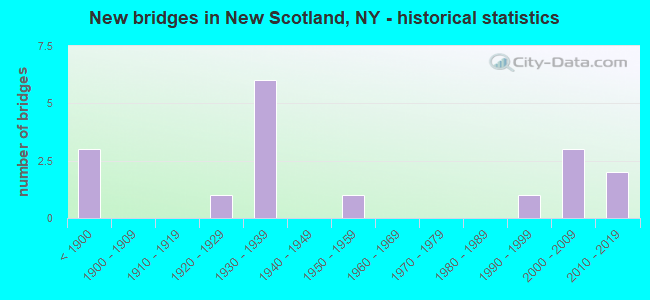
- New bridges - historical statistics
- 3Before 1900
- 11920-1929
- 61930-1939
- 11950-1959
- 11990-1999
- 32000-2009
- 22010-2019

- Reconstructed bridges - Historical Statistics
- 51980-1989
- 21990-1999


- Bridge Condition - Deck
- 16.7%Excellent
- 8.3%Very good
- 25.0%Good
- 16.7%Satisfactory
- 25.0%Fair
- 8.3%Serious

- Bridge Condition - Superstructure
- 21.4%Excellent
- 28.6%Very good
- 35.7%Good
- 7.1%Satisfactory
- 7.1%Fair

- Bridge Condition - Substructure
- 14.3%Excellent
- 35.7%Very good
- 14.3%Good
- 28.6%Fair
- 7.1%Poor

- Bridge Condition - Channel
- 7.1%Very good
- 28.6%Good
- 42.9%Satisfactory
- 21.4%Fair
Find on map >> Show street view
Structure Number: 102241, Location: 4.3 MI N JCT SH32 & SH143 (Lat: 42.563303, Lng: -73.930031), Route carried "on" structure: State highway 32, Year Built: 1931, Year Reconstructed: 1985, Status: Open, Structure Length: 2.13m (6.99ft), Average Daily Traffic: 4,458 (year 2020), Truck Traffic: 6%, Average Future Daily Traffic: 4,650 (year 2040), Design Load: HS 20, Features Intersected: ONESQUETHAW CREEK
Minimum Vertical Clearance: 30+ m (98+ ft), Kilometerpoint: 17.924, Lanes on structure: 2, Base Highway Network: Yes, Owner: State Highway Agency, Approaching Roadway Width: 8.5m (27.9ft), Skew: 5 degrees, Material/Design: Prestressed concrete, Design/Construction: Box Beam or Girders - Multiple, Number Of Spans In Main Unit: 1, Length of Maximum Span: 19.8m (65.0ft), Curb-To-Curb Width: 8.5m (27.9ft), Out-to-Out Width: 9.1m (29.9ft)
Condition: Deck: Satisfactory, Superstructure: Good, Substructure: Fair, Channel: Satisfactory, Operating Rating: 97.2 metric tons, Method Used To Determine Operating Rating: Load and Resistance Factor Rating (LRFR) rating reported by rating factor(RF) method using HL-93 loadings, Inventory Rating: 77.8 metric tons, Method Used To Determine Inventory Rating: Load and Resistance Factor Rating (LRFR) rating reported by rating factor(RF) method using HL-93 loadings, Structural Evaluation: Somewhat better than minimum adequacy, Deck Geometry: Meets minimum limits, Waterway Adequacy: Somewhat better than minimum adequacy, Approach Roadway Alignment: Equal to present desirable criteria, Length Of Structure Improvement: 2.13m (6.99ft), Designated Inspection Frequency: Every 24 months, Inspection Date: March 2021, Bridge Improvement Cost: $1,282,000, Roadway Improvement Cost: $751,000, Total Project Cost: $2,033,000 ( Estimate for 2021), Deck Structure Type: Concrete Cast-file-Place, Wearing Surface/Protective System: Wearing Surface: Integral Concrete, Deck Protection: Epoxy Coated Reinforcing
Find on map >> Show street view
Structure Number: 102528, Location: RTE 443 IN CLARKSVILLE (Lat: 42.575397, Lng: -73.973122), Route carried "on" structure: State highway 443, Year Built: 2000, Status: Open, Structure Length: 1.34m (4.40ft), Average Daily Traffic: 1,846 (year 2019), Truck Traffic: 7%, Average Future Daily Traffic: 1,925 (year 2040), Design Load: HS 25 or greater, Features Intersected: ONESQUETHAW CREEK
Minimum Vertical Clearance: 30+ m (98+ ft), Kilometerpoint: 22.075, Lanes on structure: 2, Base Highway Network: Yes, Owner: State Highway Agency, Approaching Roadway Width: 9.4m (30.8ft), Skew: 1 degrees, Material/Design: Prestressed concrete, Design/Construction: Box Beam or Girders - Multiple, Number Of Spans In Main Unit: 1, Length of Maximum Span: 12.5m (41.0ft), Curb-To-Curb Width: 10.2m (33.5ft), Out-to-Out Width: 11.3m (37.1ft)
Condition: Deck: Satisfactory, Superstructure: Excellent, Substructure: Very good, Channel: Satisfactory, Operating Rating: 86.2 metric tons, Method Used To Determine Operating Rating: Load Factor (LF), Inventory Rating: 51.7 metric tons, Method Used To Determine Inventory Rating: Load Factor (LF), Structural Evaluation: Equal to present desirable criteria, Deck Geometry: Somewhat better than minimum adequacy, Waterway Adequacy: Equal to present minimum criteria, Approach Roadway Alignment: Equal to present desirable criteria, Length Of Structure Improvement: 1.34m (4.40ft), Designated Inspection Frequency: Every 24 months, Inspection Date: July 2020, Bridge Improvement Cost: $748,000, Roadway Improvement Cost: $438,000, Total Project Cost: $1,186,000 ( Estimate for 2021), Deck Structure Type: Concrete Cast-file-Place, Wearing Surface/Protective System: Wearing Surface: Monolithic Concrete, Deck Protection: Epoxy Coated Reinforcing
Find on map >> Show street view
Structure Number: 103263, Location: .1 MI E Jct NY85 + NY443 (Lat: 42.593044, Lng: -73.985764), Route carried "on" structure: State highway 85, Year Built: 2003, Status: Open, Structure Length: 1.34m (4.40ft), Average Daily Traffic: 2,255 (year 2019), Truck Traffic: 5%, Average Future Daily Traffic: 2,352 (year 2040), Design Load: HS 25 or greater, Features Intersected: Onesquethaw Cre
Minimum Vertical Clearance: 30+ m (98+ ft), Kilometerpoint: 19.710, Lanes on structure: 2, Base Highway Network: Yes, Owner: State Highway Agency, Approaching Roadway Width: 8.5m (27.9ft), Material/Design: Concrete, Design/Construction: Frame, Number Of Spans In Main Unit: 1, Length of Maximum Span: 12.8m (42.0ft), Curb-To-Curb Width: 8.5m (27.9ft), Out-to-Out Width: 9.5m (31.2ft)
Condition: Superstructure: Very good, Substructure: Excellent, Channel: Good, Operating Rating: 70.8 metric tons, Method Used To Determine Operating Rating: Load Factor (LF), Inventory Rating: 42.6 metric tons, Method Used To Determine Inventory Rating: Load Factor (LF), Structural Evaluation: Equal to present desirable criteria, Deck Geometry: Meets minimum limits, Waterway Adequacy: Equal to present minimum criteria, Approach Roadway Alignment: Equal to present desirable criteria, Length Of Structure Improvement: 1.34m (4.40ft), Designated Inspection Frequency: Every 24 months, Inspection Date: March 2021, Bridge Improvement Cost: $306,000, Roadway Improvement Cost: $179,000, Total Project Cost: $486,000 ( Estimate for 2021)
Find on map >> Show street view
Structure Number: 103862, Location: 0.5 MI N JCT RT 85A & 155 (Lat: 42.655650, Lng: -73.917425), Route carried "on" structure: State highway 155, Year Built: 1932, Year Reconstructed: 1991, Status: Open, Structure Length: 1.19m (3.90ft), Average Daily Traffic: 7,815 (year 2018), Truck Traffic: 5%, Average Future Daily Traffic: 9,493 (year 2040), Design Load: HS 20, Features Intersected: VLY CREEK
Minimum Vertical Clearance: 30+ m (98+ ft), Kilometerpoint: 0.772, Lanes on structure: 2, Base Highway Network: Yes, Owner: State Highway Agency, Approaching Roadway Width: 9.8m (32.2ft), Material/Design: Prestressed concrete, Design/Construction: Stringer/Multi-beam, Number Of Spans In Main Unit: 1, Length of Maximum Span: 10.9m (35.8ft), Curb-To-Curb Width: 9.8m (32.2ft), Out-to-Out Width: 10.4m (34.1ft)
Condition: Deck: Fair, Superstructure: Very good, Substructure: Good, Channel: Fair, Operating Rating: 82.6 metric tons, Method Used To Determine Operating Rating: Load Factor (LF), Inventory Rating: 39.9 metric tons, Method Used To Determine Inventory Rating: Load Factor (LF), Structural Evaluation: Better than present minimum criteria, Deck Geometry: Meets minimum limits, Waterway Adequacy: Somewhat better than minimum adequacy, Approach Roadway Alignment: Equal to present desirable criteria, Length Of Structure Improvement: 1.18m (3.87ft), Designated Inspection Frequency: Every 24 months, Inspection Date: June 2021, Bridge Improvement Cost: $624,000, Roadway Improvement Cost: $365,000, Total Project Cost: $989,000 ( Estimate for 2021), Deck Structure Type: Concrete Cast-file-Place, Wearing Surface/Protective System: Wearing Surface: Monolithic Concrete
Find on map >> Show street view
Structure Number: 220014, Location: 2.1 MI NW OF CLARKSVILLE (Lat: 42.599772, Lng: -73.990275), Route carried "on" structure: Other road , Year Built: 2014, Status: Open, Structure Length: 0.98m (3.22ft), Average Daily Traffic: 136 (year 2019), Truck Traffic: 3%, Average Future Daily Traffic: 190 (year 2039), Design Load: HS 20, Features Intersected: ONESQUETHAW CREEK, Facility Carried by Structure: WOLF HILL ROAD
Minimum Vertical Clearance: 30+ m (98+ ft), Kilometerpoint: 0.837, Lanes on structure: 1, Owner: Town or Township Highway Agency, Approaching Roadway Width: 5.5m (18.0ft), Skew: 1 degrees, Material/Design: Prestressed concrete, Design/Construction: Box Beam or Girders - Multiple, Number Of Spans In Main Unit: 1, Length of Maximum Span: 8.5m (27.9ft), Curb-To-Curb Width: 5.5m (18.0ft), Out-to-Out Width: 6.4m (21.0ft)
Condition: Deck: Excellent, Superstructure: Excellent, Substructure: Excellent, Channel: Very good, Operating Rating: 76.2 metric tons, Method Used To Determine Operating Rating: Load Factor (LF), Inventory Rating: 45.4 metric tons, Method Used To Determine Inventory Rating: Load Factor (LF), Structural Evaluation: Superior to present desirable criteria, Deck Geometry: High priority of corrective action, Waterway Adequacy: Equal to present desirable criteria, Approach Roadway Alignment: Equal to present minimum criteria, Length Of Structure Improvement: 0.97m (3.18ft), Designated Inspection Frequency: Every 24 months, Inspection Date: May 2021, Bridge Improvement Cost: $251,000, Roadway Improvement Cost: $147,000, Total Project Cost: $398,000 ( Estimate for 2021), Deck Structure Type: Concrete Cast-file-Place, Wearing Surface/Protective System: Wearing Surface: Integral Concrete, Deck Protection: Epoxy Coated Reinforcing
Find on map >> Show street view
Structure Number: 330127, Location: 3 MI E OF VOORHEESVILLE (Lat: 42.663658, Lng: -73.882381), Route carried "on" structure: Other road , Year Built: 1939, Year Reconstructed: 1992, Status: Open, Structure Length: 4.15m (13.62ft), Average Daily Traffic: 2,192 (year 2019), Truck Traffic: 3%, Average Future Daily Traffic: 2,712 (year 2040), Design Load: HS 20, Features Intersected: NORMANSKILL CREEK, Facility Carried by Structure: KRUMKILL ROAD
Minimum Vertical Clearance: 30+ m (98+ ft), Kilometerpoint: 1.448, Lanes on structure: 2, Owner: County Highway Agency, Approaching Roadway Width: 7.9m (25.9ft), Skew: 2 degrees, Material/Design: Steel, Design/Construction: Truss - Thru, Number Of Spans In Main Unit: 1, Length of Maximum Span: 39.6m (129.9ft), Curb-To-Curb Width: 7.9m (25.9ft), Out-to-Out Width: 8.4m (27.6ft)
Condition: Deck: Good, Superstructure: Fair, Substructure: Fair, Channel: Fair, Operating Rating: 27.9 metric tons, Method Used To Determine Operating Rating: Load and Resistance Factor Rating (LRFR) rating reported by rating factor(RF) method using HL-93 loadings, Inventory Rating: 21.4 metric tons, Method Used To Determine Inventory Rating: Load and Resistance Factor Rating (LRFR) rating reported by rating factor(RF) method using HL-93 loadings, Structural Evaluation: Somewhat better than minimum adequacy, Deck Geometry: High priority of corrective action, Waterway Adequacy: Equal to present desirable criteria, Approach Roadway Alignment: Equal to present desirable criteria, Length Of Structure Improvement: 4.14m (13.58ft), Designated Inspection Frequency: Every 24 months, Critical Feature Inspection Frequency: Every 24 months, Inspection Date: June 2020, Critical Feature Inspection Date: June 2020, Bridge Improvement Cost: $2,962,000, Roadway Improvement Cost: $1,734,000, Total Project Cost: $4,696,000 ( Estimate for 2021), Deck Structure Type: Concrete Cast-file-Place, Wearing Surface/Protective System: Wearing Surface: Integral Concrete, Deck Protection: Epoxy Coated Reinforcing
Find on map >> Show street view
Structure Number: 330128, Location: .5 MI E OF VOORHEESVILLE (Lat: 42.658278, Lng: -73.908300), Route carried "on" structure: County highway , Year Built: 1999, Status: Open, Structure Length: 2.19m (7.19ft), Average Daily Traffic: 2,427 (year 2018), Truck Traffic: 3%, Average Future Daily Traffic: 3,002 (year 2040), Design Load: HS 25 or greater, Features Intersected: VLY CREEK, Facility Carried by Structure: COUNTY ROAD 306
Minimum Vertical Clearance: 30+ m (98+ ft), Kilometerpoint: 2.317, Lanes on structure: 2, Owner: County Highway Agency, Approaching Roadway Width: 9.1m (29.9ft), Material/Design: Steel, Design/Construction: Stringer/Multi-beam, Number Of Spans In Main Unit: 1, Length of Maximum Span: 21.3m (69.9ft), Curb-To-Curb Width: 9.1m (29.9ft), Out-to-Out Width: 10.0m (32.8ft)
Condition: Deck: Good, Superstructure: Good, Substructure: Very good, Channel: Satisfactory, Operating Rating: 97.2 metric tons, Method Used To Determine Operating Rating: Load and Resistance Factor Rating (LRFR) rating reported by rating factor(RF) method using HL-93 loadings, Inventory Rating: 81.3 metric tons, Method Used To Determine Inventory Rating: Load and Resistance Factor Rating (LRFR) rating reported by rating factor(RF) method using HL-93 loadings, Structural Evaluation: Better than present minimum criteria, Deck Geometry: Meets minimum limits, Waterway Adequacy: Equal to present minimum criteria, Approach Roadway Alignment: Equal to present desirable criteria, Length Of Structure Improvement: 2.19m (7.19ft), Designated Inspection Frequency: Every 24 months, Inspection Date: March 2020, Bridge Improvement Cost: $522,000, Roadway Improvement Cost: $306,000, Total Project Cost: $827,000 ( Estimate for 2021), Deck Structure Type: Concrete Cast-file-Place, Wearing Surface/Protective System: Wearing Surface: Integral Concrete, Deck Protection: Epoxy Coated Reinforcing
Find on map >> Show street view
Structure Number: 33013, Location: 1.7 MI S OF FEURA BUSH (Lat: 42.552967, Lng: -73.888792), Route carried "on" structure: Other road , Year Built: 1882, Year Reconstructed: 1989, Status: Open, Structure Length: 2.10m (6.89ft), Average Daily Traffic: 111 (year 2019), Truck Traffic: 6%, Average Future Daily Traffic: 155 (year 2039), Design Load: HS 20, Features Intersected: ONESQUETHAW CREEK, Facility Carried by Structure: ROWE ROAD
Minimum Vertical Clearance: 30+ m (98+ ft), Kilometerpoint: 2.719, Lanes on structure: 1, Owner: County Highway Agency, Approaching Roadway Width: 4.6m (15.1ft), Material/Design: Steel, Design/Construction: Truss - Thru, Number Of Spans In Main Unit: 1, Length of Maximum Span: 20.7m (67.9ft), Curb-To-Curb Width: 3.7m (12.1ft), Out-to-Out Width: 4.0m (13.1ft)
Condition: Deck: Fair, Superstructure: Very good, Substructure: Fair, Channel: Good, Operating Rating: 56.2 metric tons, Method Used To Determine Operating Rating: Load Factor (LF), Inventory Rating: 33.6 metric tons, Method Used To Determine Inventory Rating: Load Factor (LF), Structural Evaluation: Somewhat better than minimum adequacy, Deck Geometry: High priority of replacement, Waterway Adequacy: Somewhat better than minimum adequacy, Approach Roadway Alignment: Equal to present minimum criteria, Length Of Structure Improvement: 2.10m (6.89ft), Designated Inspection Frequency: Every 24 months, Critical Feature Inspection Frequency: Every 24 months, Inspection Date: June 2021, Critical Feature Inspection Date: June 2021, Bridge Improvement Cost: $615,000, Roadway Improvement Cost: $360,000, Total Project Cost: $976,000 ( Estimate for 2021), Deck Structure Type: Wood or Timber, Wearing Surface/Protective System: Wearing Surface: Bituminous
Find on map >> Show street view
Structure Number: 330131, Location: 2 MI SW OF FEURA BUSH (Lat: 42.556942, Lng: -73.909942), Route carried "on" structure: Other road , Year Built: 1886, Year Reconstructed: 1991, Status: Open, Structure Length: 1.52m (4.99ft), Average Daily Traffic: 124 (year 2019), Truck Traffic: 6%, Average Future Daily Traffic: 174 (year 2039), Features Intersected: ONESQUETHAW CREEK, Facility Carried by Structure: ONESQUETHAW CK RD
Minimum Vertical Clearance: 30+ m (98+ ft), Kilometerpoint: 2.172, Lanes on structure: 1, Owner: County Highway Agency, Approaching Roadway Width: 4.0m (13.1ft), Material/Design: Steel, Design/Construction: Truss - Thru, Number Of Spans In Main Unit: 1, Length of Maximum Span: 14.6m (47.9ft), Curb-To-Curb Width: 3.7m (12.1ft), Out-to-Out Width: 3.7m (12.1ft)
Condition: Deck: Fair, Superstructure: Satisfactory, Substructure: Poor, Channel: Fair, Operating Rating: 95.3 metric tons, Method Used To Determine Operating Rating: Load Factor (LF), Inventory Rating: 57.2 metric tons, Method Used To Determine Inventory Rating: Load Factor (LF), Structural Evaluation: Meets minimum limits, Deck Geometry: High priority of replacement, Waterway Adequacy: Meets minimum limits, Approach Roadway Alignment: Meets minimum limits, Length Of Structure Improvement: 1.52m (4.99ft), Designated Inspection Frequency: Every 24 months, Critical Feature Inspection Frequency: Every 24 months, Inspection Date: March 2021, Critical Feature Inspection Date: March 2021, Bridge Improvement Cost: $402,000, Roadway Improvement Cost: $235,000, Total Project Cost: $637,000 ( Estimate for 2021), Deck Structure Type: Wood or Timber, Wearing Surface/Protective System: Wearing Surface: Bituminous
Find on map >> Show street view
Structure Number: 330132, Location: VILLAGE OF CLARKSVILLE (Lat: 42.575133, Lng: -73.972139), Route carried "on" structure: County highway , Year Built: 2001, Status: Open, Structure Length: 1.71m (5.61ft), Average Daily Traffic: 584 (year 2019), Truck Traffic: 7%, Average Future Daily Traffic: 818 (year 2039), Design Load: HS 25 or greater, Features Intersected: ONESQUETHAW CREEK, Facility Carried by Structure: CLARKSVILLE SO RD
Minimum Vertical Clearance: 30+ m (98+ ft), Kilometerpoint: 9.203, Lanes on structure: 2, Owner: County Highway Agency, Approaching Roadway Width: 8.5m (27.9ft), Skew: 2 degrees, Material/Design: Steel, Design/Construction: Stringer/Multi-beam, Number Of Spans In Main Unit: 1, Length of Maximum Span: 15.2m (49.9ft), Curb-To-Curb Width: 8.5m (27.9ft), Out-to-Out Width: 9.1m (29.9ft)
Condition: Deck: Good, Superstructure: Very good, Substructure: Very good, Channel: Satisfactory, Operating Rating: 93.0 metric tons, Method Used To Determine Operating Rating: Load and Resistance Factor Rating (LRFR) rating reported by rating factor(RF) method using HL-93 loadings, Inventory Rating: 71.9 metric tons, Method Used To Determine Inventory Rating: Load and Resistance Factor Rating (LRFR) rating reported by rating factor(RF) method using HL-93 loadings, Structural Evaluation: Equal to present desirable criteria, Deck Geometry: Somewhat better than minimum adequacy, Waterway Adequacy: Equal to present desirable criteria, Approach Roadway Alignment: Equal to present desirable criteria, Length Of Structure Improvement: 1.70m (5.58ft), Designated Inspection Frequency: Every 24 months, Inspection Date: April 2020, Bridge Improvement Cost: $604,000, Roadway Improvement Cost: $353,000, Total Project Cost: $957,000 ( Estimate for 2021), Deck Structure Type: Concrete Cast-file-Place, Wearing Surface/Protective System: Wearing Surface: Integral Concrete
Find on map >> Show street view
Structure Number: 330133, Location: VILLAGE OF CLARKSVILLE (Lat: 42.573647, Lng: -73.959869), Route carried "on" structure: County highway , Year Built: 1931, Status: Open, Structure Length: 1.46m (4.79ft), Average Daily Traffic: 707 (year 2019), Truck Traffic: 13%, Average Future Daily Traffic: 737 (year 2040), Features Intersected: ONESQUETHAW CREEK, Facility Carried by Structure: COUNTY ROAD 301
Minimum Vertical Clearance: 30+ m (98+ ft), Kilometerpoint: 0.434, Lanes on structure: 2, Owner: County Highway Agency, Approaching Roadway Width: 7.9m (25.9ft), Skew: 3 degrees, Material/Design: Concrete, Design/Construction: Arch - Deck, Number Of Spans In Main Unit: 1, Length of Maximum Span: 12.1m (39.7ft), Curb-To-Curb Width: 6.9m (22.6ft), Out-to-Out Width: 8.8m (28.9ft)
Condition: Superstructure: Good, Substructure: Good, Channel: Satisfactory, Operating Rating: 60.0 metric tons, Method Used To Determine Operating Rating: Field evaluation and documented engineering judgment, Inventory Rating: 25.0 metric tons, Method Used To Determine Inventory Rating: Field evaluation and documented engineering judgment, Structural Evaluation: Equal to present minimum criteria, Deck Geometry: Meets minimum limits, Waterway Adequacy: Meets minimum limits, Approach Roadway Alignment: High priority of corrective action, Length Of Structure Improvement: 2.13m (6.99ft), Designated Inspection Frequency: Every 24 months, Inspection Date: April 2021, Bridge Improvement Cost: $788,000, Roadway Improvement Cost: $462,000, Total Project Cost: $1,250,000 ( Estimate for 2021)
Find on map >> Show street view
Structure Number: 330134, Location: 1.4 MI SE OF CLARKSVILLE (Lat: 42.568764, Lng: -73.937453), Route carried "on" structure: Other road , Year Built: 1898, Year Reconstructed: 1999, Status: Posted for load, Structure Length: 2.04m (6.69ft), Average Daily Traffic: 60 (year 2019), Truck Traffic: 11%, Average Future Daily Traffic: 84 (year 2039), Design Load: HS 20, Features Intersected: ONESQUETHAW CREEK, Facility Carried by Structure: OLD PLANK RD
Minimum Vertical Clearance: 30+ m (98+ ft), Kilometerpoint: 0.257, Lanes on structure: 1, Owner: County Highway Agency, Approaching Roadway Width: 3.7m (12.1ft), Material/Design: Steel, Design/Construction: Truss - Thru, Number Of Spans In Main Unit: 1, Length of Maximum Span: 19.5m (64.0ft), Curb-To-Curb Width: 3.7m (12.1ft), Out-to-Out Width: 4.0m (13.1ft)
Condition: Deck: Serious, Superstructure: Good, Substructure: Fair, Channel: Satisfactory, Operating Rating: 31.8 metric tons, Method Used To Determine Operating Rating: Load and Resistance Factor Rating (LRFR) rating reported by rating factor(RF) method using HL-93 loadings, Inventory Rating: 24.3 metric tons, Method Used To Determine Inventory Rating: Load and Resistance Factor Rating (LRFR) rating reported by rating factor(RF) method using HL-93 loadings, Structural Evaluation: Somewhat better than minimum adequacy, Deck Geometry: Meets minimum limits, Waterway Adequacy: Somewhat better than minimum adequacy, Approach Roadway Alignment: Somewhat better than minimum adequacy, Bridge Posting: Required (Relationship of Operating Rating to Maximum Legal Load: > 39.9% below), Length Of Structure Improvement: 2.04m (6.69ft), Designated Inspection Frequency: Every 12 months, Critical Feature Inspection Frequency: Every 12 months, Inspection Date: April 2021, Critical Feature Inspection Date: April 2021, Bridge Improvement Cost: $653,000, Roadway Improvement Cost: $382,000, Total Project Cost: $1,035,000 ( Estimate for 2021), Deck Structure Type: Wood or Timber, Wearing Surface/Protective System: Wearing Surface: Bituminous
Find on map >> Show street view
Structure Number: 330135, Location: 1.7 MI SE OF CLARKSVILLE (Lat: 42.567306, Lng: -73.933114), Route carried "on" structure: ServiceOther road , Year Built: 2015, Status: Open, Structure Length: 1.98m (6.50ft), Average Daily Traffic: 80 (year 2019), Truck Traffic: 6%, Average Future Daily Traffic: 112 (year 2039), Design Load: HL 93, Features Intersected: ONESQUETHAW CREEK, Facility Carried by Structure: GROESBECK ROAD
Minimum Vertical Clearance: 30+ m (98+ ft), Kilometerpoint: 1.689, Lanes on structure: 2, Owner: County Highway Agency, Approaching Roadway Width: 7.3m (24.0ft), Material/Design: Steel, Design/Construction: Stringer/Multi-beam, Number Of Spans In Main Unit: 1, Length of Maximum Span: 18.9m (62.0ft), Curb-To-Curb Width: 7.3m (24.0ft), Out-to-Out Width: 8.1m (26.6ft)
Condition: Deck: Excellent, Superstructure: Excellent, Substructure: Very good, Channel: Good, Operating Rating: 40.2 metric tons, Method Used To Determine Operating Rating: Load and Resistance Factor Rating (LRFR) rating reported by rating factor(RF) method using HL-93 loadings, Inventory Rating: 31.1 metric tons, Method Used To Determine Inventory Rating: Load and Resistance Factor Rating (LRFR) rating reported by rating factor(RF) method using HL-93 loadings, Structural Evaluation: Better than present minimum criteria, Deck Geometry: Equal to present minimum criteria, Waterway Adequacy: Meets minimum limits, Approach Roadway Alignment: Better than present minimum criteria, Length Of Structure Improvement: 1.98m (6.50ft), Designated Inspection Frequency: Every 24 months, Inspection Date: March 2020, Bridge Improvement Cost: $384,000, Roadway Improvement Cost: $225,000, Total Project Cost: $608,000 ( Estimate for 2021), Deck Structure Type: Concrete Cast-file-Place, Wearing Surface/Protective System: Wearing Surface: Integral Concrete, Deck Protection: Epoxy Coated Reinforcing
Find on map >> Show street view
Structure Number: 552423, Location: 0.8 MI NW JCT RT 443 (Lat: 42.608697, Lng: -73.892172), Route carried "on" structure: Other road , Year Built: 1930, Year Reconstructed: 1997, Status: Open, Structure Length: 1.13m (3.71ft), Average Daily Traffic: 212 (year 2020), Truck Traffic: 5%, Average Future Daily Traffic: 297 (year 2040), Design Load: HS 20+Mod, Features Intersected: VLOMAN KILL, Facility Carried by Structure: GAME FARM ROAD
Minimum Vertical Clearance: 30+ m (98+ ft), Kilometerpoint: 1.062, Lanes on structure: 2, Owner: State Agenciy, Approaching Roadway Width: 5.8m (19.0ft), Material/Design: Steel, Design/Construction: Stringer/Multi-beam, Number Of Spans In Main Unit: 1, Length of Maximum Span: 10.9m (35.8ft), Curb or Sidewalk Widths: Left: 1.2m (3.9ft), Right: 0.0m, Curb-To-Curb Width: 5.5m (18.0ft), Out-to-Out Width: 7.3m (24.0ft)
Condition: Deck: Very good, Superstructure: Good, Substructure: Very good, Channel: Good, Operating Rating: 80.4 metric tons, Method Used To Determine Operating Rating: Field evaluation and documented engineering judgment, Inventory Rating: 32.7 metric tons, Method Used To Determine Inventory Rating: Field evaluation and documented engineering judgment, Structural Evaluation: Better than present minimum criteria, Deck Geometry: High priority of corrective action, Waterway Adequacy: Equal to present minimum criteria, Approach Roadway Alignment: High priority of corrective action, Length Of Structure Improvement: 1.12m (3.67ft), Designated Inspection Frequency: Every 24 months, Inspection Date: May 2021, Bridge Improvement Cost: $294,000, Roadway Improvement Cost: $172,000, Total Project Cost: $466,000 ( Estimate for 2021), Deck Structure Type: Concrete Precast Panels, Wearing Surface/Protective System: Wearing Surface: Latex Concrete
Find on map >> Show street view
Structure Number: 702529, Location: S H 443 & CSX TRANSPORT (Lat: 42.600325, Lng: -73.892347), Route carried "under" structure: State highway 443, Year Built: 1927, Structure Length: 0. m, Average Daily Traffic: 1,550 (year 1979), Features Intersected: RTE 443, Facility Carried by Structure: CSX TRANSPRTATION
Minimum Vertical Clearance: 4.11m (13.48ft), Kilometerpoint: 29.734, Lanes under structure: 2, Material/Design: Steel, Design/Construction: Girder and Floorbeam System, Length of Maximum Span: 11.2m (36.7ft)
Find on map >> Show street view
Structure Number: 703264, Location: 0.7 MI W JCT RTS 85 & 85A (Lat: 42.628750, Lng: -73.913478), Route carried "under" structure: State highway 85, Year Built: 1951, Structure Length: 0. m, Average Daily Traffic: 9,729 (year 1999), Features Intersected: RTE 85, Facility Carried by Structure: CSX TRANSPORT
Minimum Vertical Clearance: 4.11m (13.48ft), Kilometerpoint: 29.316, Lanes under structure: 2, Material/Design: Steel, Design/Construction: Stringer/Multi-beam, Length of Maximum Span: 21.0m (68.9ft)
Find on map >> Show street view
Structure Number: 703861, Location: .3 MI N JCT SH85A & SH155 (Lat: 42.652319, Lng: -73.919394), Route carried "under" structure: State highway 155, Year Built: 1934, Structure Length: 0. m, Average Daily Traffic: 10,179 (year 2002), Features Intersected: RTE 155, Facility Carried by Structure: ALBANY COUNTY RAIL
Minimum Vertical Clearance: 4.44m (14.57ft), Kilometerpoint: 0.370, Lanes under structure: 2, Material/Design: Steel, Design/Construction: Girder and Floorbeam System, Length of Maximum Span: 11.5m (37.7ft)