Bridge Statistics for North Highlands, California (CA)
Condition, Traffic, Stress, Structural Evaluation, Project Costs
- National Bridge Inventory (NBI) Statistics
- 29Number of bridges
- 413ft / 126mTotal length
- 1,873,935Total average daily traffic
- 102,366Total average daily truck traffic
- National Bridge Inventory (NBI) Registered Bridges for North Highlands
- No street view available for this location
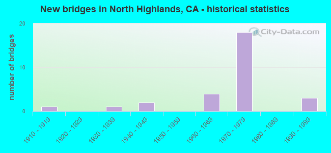
- New bridges - historical statistics
- 11910-1919
- 11930-1939
- 21940-1949
- 41960-1969
- 181970-1979
- 31990-1999

- Reconstructed bridges - Historical Statistics
- 21960-1969
- 01970-1979
- 21980-1989
- 21990-1999
- 12000-2009


- Bridge Condition - Deck
- 66.7%Good
- 8.3%Satisfactory
- 25.0%Fair

- Bridge Condition - Superstructure
- 58.3%Good
- 8.3%Satisfactory
- 33.3%Fair

- Bridge Condition - Substructure
- 66.7%Good
- 16.7%Satisfactory
- 16.7%Fair

- Bridge Condition - Channel
- 33.3%Very good
- 33.3%Good
- 16.7%Satisfactory
- 16.7%Fair

- Bridge Condition - Culverts
- 66.7%Good
- 33.3%Satisfactory
Find on map >> Show street view
Structure Number: 7C0007, Location: 2.2 MI E US HWY 395 (Lat: 40.135531, Lng: -120.209639), Route carried "on" structure: County highway , Year Built: 1979, Status: Open, Structure Length: 7.70m (25.26ft), Average Daily Traffic: 800 (year 1980), Truck Traffic: 7%, Average Future Daily Traffic: 1,008 (year 2043), Design Load: HS 20, Features Intersected: LONG VALLEY CREEK, Facility Carried by Structure: HERLONG ACCESS RD
Minimum Vertical Clearance: 30+ m (98+ ft), Kilometerpoint: 0.000, Lanes on structure: 2, Owner: County Highway Agency, Approaching Roadway Width: 7.3m (24.0ft), Skew: 1 degrees, Material/Design: Concrete continuous, Design/Construction: Slab, Number Of Spans In Main Unit: 10, Length of Maximum Span: 7.6m (24.9ft), Curb-To-Curb Width: 9.1m (29.9ft), Out-to-Out Width: 9.3m (30.5ft)
Condition: Deck: Good, Superstructure: Good, Substructure: Good, Channel: Good, Operating Rating: 39.5 metric tons, Method Used To Determine Operating Rating: Load and Resistance Factor Rating (LRFR) rating reported by rating factor(RF) method using HL-93 loadings, Inventory Rating: 27.9 metric tons, Method Used To Determine Inventory Rating: Load and Resistance Factor Rating (LRFR) rating reported by rating factor(RF) method using HL-93 loadings, Structural Evaluation: Better than present minimum criteria, Deck Geometry: Equal to present minimum criteria, Waterway Adequacy: Equal to present desirable criteria, Approach Roadway Alignment: Equal to present desirable criteria, Designated Inspection Frequency: Every 24 months, Inspection Date: September 2021, Deck Structure Type: Concrete Cast-file-Place
Find on map >> Show street view
Structure Number: 7C0016, Location: 0.3 MI S OF S.H. 36 (Lat: 40.413778, Lng: -120.664061), Route carried "on" structure: City street , Year Built: 1965, Status: Open, Structure Length: 2.41m (7.91ft), Average Daily Traffic: 400 (year 1980), Truck Traffic: 1%, Average Future Daily Traffic: 875 (year 2042), Design Load: HS 20, Features Intersected: SUSAN RIVER, Facility Carried by Structure: LASSEN ST
Minimum Vertical Clearance: 30+ m (98+ ft), Kilometerpoint: 0.000, Lanes on structure: 2, Owner: City or Municipal Highway Agency, Approaching Roadway Width: 7.9m (25.9ft), Skew: 5 degrees, Material/Design: Concrete, Design/Construction: Box Beam or Girders - Multiple, Number Of Spans In Main Unit: 1, Length of Maximum Span: 23.5m (77.1ft), Curb-To-Curb Width: 7.9m (25.9ft), Out-to-Out Width: 8.1m (26.6ft)
Condition: Deck: Fair, Superstructure: Fair, Substructure: Fair, Channel: Good, Operating Rating: 49.2 metric tons, Method Used To Determine Operating Rating: Load and Resistance Factor Rating (LRFR) rating reported by rating factor(RF) method using HL-93 loadings, Inventory Rating: 37.9 metric tons, Method Used To Determine Inventory Rating: Load and Resistance Factor Rating (LRFR) rating reported by rating factor(RF) method using HL-93 loadings, Structural Evaluation: Somewhat better than minimum adequacy, Deck Geometry: Somewhat better than minimum adequacy, Waterway Adequacy: Somewhat better than minimum adequacy, Approach Roadway Alignment: Equal to present minimum criteria, Designated Inspection Frequency: Every 24 months, Inspection Date: September 2021, Deck Structure Type: Concrete Cast-file-Place, Wearing Surface/Protective System: Deck Protection: Epoxy Coated Reinforcing
Find on map >> Show street view
Structure Number: 24 0127, Location: 03-SAC-080-12.48 (Lat: 38.661006, Lng: -121.360703), Route carried "on" structure: County highway , Year Built: 1966, Year Reconstructed: 2004, Status: Open, Structure Length: 10.01m (32.84ft), Average Daily Traffic: 120,000 (year 2010), Truck Traffic: 2%, Average Future Daily Traffic: 193,030 (year 2041), Design Load: HS 20, Features Intersected: INTERSTATE 80, Facility Carried by Structure: MADISON AVE
Minimum Vertical Clearance: 30+ m (98+ ft), Kilometerpoint: 0.000, Lanes on structure: 7, Lanes under structure: 11, Base Highway Network: Yes, Owner: State Highway Agency, Approaching Roadway Width: 31.0m (101.7ft), Skew: 24 degrees, Material/Design: Prestressed concrete continuous, Design/Construction: Box Beam or Girders - Multiple, Number Of Spans In Main Unit: 2, Length of Maximum Span: 49.4m (162.1ft), Curb or Sidewalk Widths: Left: 1.5m (4.9ft), Right: 1.5m (4.9ft), Curb-To-Curb Width: 31.0m (101.7ft), Out-to-Out Width: 34.8m (114.2ft)
Condition: Deck: Good, Superstructure: Good, Substructure: Fair, Operating Rating: 64.5 metric tons, Method Used To Determine Operating Rating: Load and Resistance Factor Rating (LRFR) rating reported by rating factor(RF) method using HL-93 loadings, Inventory Rating: 40.8 metric tons, Method Used To Determine Inventory Rating: Load and Resistance Factor Rating (LRFR) rating reported by rating factor(RF) method using HL-93 loadings, Structural Evaluation: Somewhat better than minimum adequacy, Deck Geometry: Better than present minimum criteria, Underclear: Equal to present minimum criteria, Approach Roadway Alignment: Equal to present desirable criteria, Designated Inspection Frequency: Every 24 months, Inspection Date: January 2021, Deck Structure Type: Concrete Cast-file-Place, Wearing Surface/Protective System: Wearing Surface: Bituminous
Find on map >> Show street view
Structure Number: 24 0291L, Location: 03-SAC-051-8.46 (Lat: 38.645389, Lng: -121.377667), Route carried "on" structure: Ramp State highway 51, Year Built: 1971, Year Reconstructed: 2001, Status: Open, Structure Length: 51.11m (167.68ft), Average Daily Traffic: 145,000 (year 2010), Truck Traffic: 6%, Average Future Daily Traffic: 180,203 (year 2039), Design Load: HS 20+Mod, Features Intersected: I 80 & SR 244
Minimum Vertical Clearance: 30+ m (98+ ft), Kilometerpoint: 8.460, Lanes on structure: 5, Lanes under structure: 14, Owner: State Highway Agency, Approaching Roadway Width: 22.5m (73.8ft), Skew: 5 degrees, Material/Design: Prestressed concrete continuous, Design/Construction: Box Beam or Girders - Multiple, Number Of Spans In Main Unit: 11, Number Of Approach Spans: 7, Length of Maximum Span: 62.5m (205.1ft), Curb-To-Curb Width: 22.5m (73.8ft), Out-to-Out Width: 23.5m (77.1ft)
Condition: Deck: Satisfactory, Superstructure: Satisfactory, Substructure: Satisfactory, Operating Rating: 54.1 metric tons, Method Used To Determine Operating Rating: Assigned rating based on Load Factor Design (LFD) reported in metric tons, Inventory Rating: 32.4 metric tons, Method Used To Determine Inventory Rating: Assigned rating based on Load Factor Design (LFD) reported in metric tons, Structural Evaluation: Equal to present minimum criteria, Deck Geometry: Superior to present desirable criteria, Underclear: Equal to present minimum criteria, Approach Roadway Alignment: Better than present minimum criteria, Designated Inspection Frequency: Every 24 months, Inspection Date: November 2021, Deck Structure Type: Concrete Cast-file-Place, Wearing Surface/Protective System: Wearing Surface: Integral Concrete
Find on map >> Show street view
Structure Number: 24 0292L, Location: 03-SAC-080-R11.08 (Lat: 38.647092, Lng: -121.375789), Route carried "on" structure: Interstate 80, Year Built: 1971, Status: Open, Structure Length: 8.57m (28.12ft), Average Daily Traffic: 125,000 (year 2010), Truck Traffic: 6%, Average Future Daily Traffic: 136,275 (year 2041), Design Load: HS 20+Mod, Features Intersected: SR 244 WB
Minimum Vertical Clearance: 30+ m (98+ ft), Kilometerpoint: 11.080, Lanes on structure: 4, Lanes under structure: 5, Base Highway Network: Yes (, Subroute: 2), Owner: State Highway Agency, Approaching Roadway Width: 24.4m (80.1ft), Skew: 6 degrees, Material/Design: Prestressed concrete, Design/Construction: Box Beam or Girders - Multiple, Number Of Spans In Main Unit: 1, Number Of Approach Spans: 2, Length of Maximum Span: 49.0m (160.8ft), Curb-To-Curb Width: 23.8m (78.1ft), Out-to-Out Width: 24.4m (80.1ft)
Condition: Deck: Good, Superstructure: Good, Substructure: Good, Operating Rating: 72.3 metric tons, Method Used To Determine Operating Rating: Load Factor (LF), Inventory Rating: 32.4 metric tons, Method Used To Determine Inventory Rating: Load Factor (LF), Structural Evaluation: Better than present minimum criteria, Deck Geometry: Superior to present desirable criteria, Underclear: Equal to present minimum criteria, Approach Roadway Alignment: Equal to present desirable criteria, Designated Inspection Frequency: Every 24 months, Inspection Date: January 2021, Deck Structure Type: Concrete Cast-file-Place, Wearing Surface/Protective System: Wearing Surface: Integral Concrete
Find on map >> Show street view
Structure Number: 24 0292R, Location: 03-SAC-080-R11.09 (Lat: 38.647192, Lng: -121.375069), Route carried "on" structure: Interstate 80, Year Built: 1971, Year Reconstructed: 2005, Status: Open, Structure Length: 8.27m (27.13ft), Average Daily Traffic: 125,000 (year 2010), Truck Traffic: 6%, Average Future Daily Traffic: 136,275 (year 2041), Design Load: HS 20, Features Intersected: W244-W80 CONNECTOR RAMP
Minimum Vertical Clearance: 30+ m (98+ ft), Kilometerpoint: 11.090, Lanes on structure: 8, Lanes under structure: 5, Base Highway Network: Yes (, Subroute: 2), Owner: State Highway Agency, Approaching Roadway Width: 35.7m (117.1ft), Skew: 14 degrees, Material/Design: Prestressed concrete, Design/Construction: Box Beam or Girders - Multiple, Number Of Spans In Main Unit: 1, Number Of Approach Spans: 2, Length of Maximum Span: 49.8m (163.4ft), Curb-To-Curb Width: 23.8m (78.1ft), Out-to-Out Width: 41.2m (135.2ft)
Condition: Deck: Good, Superstructure: Fair, Substructure: Good, Operating Rating: 88.8 metric tons, Method Used To Determine Operating Rating: Load Factor (LF), Inventory Rating: 32.4 metric tons, Method Used To Determine Inventory Rating: Load Factor (LF), Structural Evaluation: Somewhat better than minimum adequacy, Deck Geometry: High priority of replacement, Underclear: Equal to present minimum criteria, Approach Roadway Alignment: Equal to present desirable criteria, Designated Inspection Frequency: Every 24 months, Inspection Date: January 2021, Deck Structure Type: Concrete Cast-file-Place, Wearing Surface/Protective System: Wearing Surface: Integral Concrete
Find on map >> Show street view
Structure Number: 24 0293R, Location: 03-SAC-051-8.52 (Lat: 38.645889, Lng: -121.376294), Route carried "on" structure: Ramp State highway 51, Year Built: 1971, Status: Open, Structure Length: 11.55m (37.89ft), Average Daily Traffic: 75,000 (year 2010), Truck Traffic: 6%, Average Future Daily Traffic: 97,761 (year 2039), Design Load: HS 20+Mod, Features Intersected: E80-E244 CONNECTOR RAMP
Minimum Vertical Clearance: 30+ m (98+ ft), Kilometerpoint: 8.520, Lanes on structure: 2, Lanes under structure: 5, Owner: State Highway Agency, Approaching Roadway Width: 12.7m (41.7ft), Skew: 6 degrees, Material/Design: Prestressed concrete, Design/Construction: Box Beam or Girders - Multiple, Number Of Spans In Main Unit: 1, Number Of Approach Spans: 2, Length of Maximum Span: 74.1m (243.1ft), Curb-To-Curb Width: 12.7m (41.7ft), Out-to-Out Width: 13.3m (43.6ft)
Condition: Deck: Good, Superstructure: Fair, Substructure: Good, Operating Rating: 99.8 metric tons, Method Used To Determine Operating Rating: Load Factor (LF), Inventory Rating: 32.4 metric tons, Method Used To Determine Inventory Rating: Load Factor (LF), Structural Evaluation: Somewhat better than minimum adequacy, Deck Geometry: Superior to present desirable criteria, Underclear: High priority of corrective action, Approach Roadway Alignment: Equal to present desirable criteria, Designated Inspection Frequency: Every 24 months, Inspection Date: November 2021, Deck Structure Type: Concrete Cast-file-Place, Wearing Surface/Protective System: Wearing Surface: Integral Concrete
Find on map >> Show street view
Structure Number: 24C0049, Location: 0.1 MI E GARFIELD AVE (Lat: 38.660667, Lng: -121.336092), Route carried "on" structure: Business County highway , Year Built: 1947, Year Reconstructed: 1980, Status: Open, Structure Length: 2.47m (8.10ft), Average Daily Traffic: 30,000 (year 2002), Truck Traffic: 10%, Average Future Daily Traffic: 43,760 (year 2042), Design Load: HS 20, Features Intersected: ARCADE CREEK, Facility Carried by Structure: MADISON AVE
Minimum Vertical Clearance: 30+ m (98+ ft), Kilometerpoint: 0.000, Lanes on structure: 6, Base Highway Network: Yes, Owner: County Highway Agency, Approaching Roadway Width: 25.0m (82.0ft), Skew: 20 degrees, Material/Design: Concrete continuous, Design/Construction: Slab, Number Of Spans In Main Unit: 5, Length of Maximum Span: 7.9m (25.9ft), Curb or Sidewalk Widths: Left: 1.5m (4.9ft), Right: 1.5m (4.9ft), Curb-To-Curb Width: 22.9m (75.1ft), Out-to-Out Width: 30.8m (101.0ft)
Condition: Deck: Good, Superstructure: Good, Substructure: Good, Channel: Satisfactory, Operating Rating: 60.9 metric tons, Method Used To Determine Operating Rating: Load Factor (LF), Inventory Rating: 36.6 metric tons, Method Used To Determine Inventory Rating: Load Factor (LF), Structural Evaluation: Better than present minimum criteria, Deck Geometry: Meets minimum limits, Waterway Adequacy: Better than present minimum criteria, Approach Roadway Alignment: Equal to present desirable criteria, Designated Inspection Frequency: Every 48 months, Inspection Date: January 2020, Deck Structure Type: Concrete Cast-file-Place, Wearing Surface/Protective System: Wearing Surface: Bituminous
Find on map >> Show street view
Structure Number: 24C0149, Location: AT ROSEVILLE RD (Lat: 38.662931, Lng: -121.379514), Route carried "on" structure: County highway , Year Built: 1973, Status: Open, Structure Length: 10.18m (33.40ft), Average Daily Traffic: 17,000 (year 2018), Truck Traffic: 10%, Average Future Daily Traffic: 21,333 (year 2042), Design Load: HS 20+Mod, Features Intersected: UP,BNSF,AMTRAK,ROSEVILLE, Facility Carried by Structure: AIR BASE DRIVE
Minimum Vertical Clearance: 30+ m (98+ ft), Kilometerpoint: 0.000, Lanes on structure: 4, Lanes under structure: 2, Owner: County Highway Agency, Approaching Roadway Width: 19.5m (64.0ft), Skew: 2 degrees, Material/Design: Prestressed concrete continuous, Design/Construction: Box Beam or Girders - Multiple, Number Of Spans In Main Unit: 3, Length of Maximum Span: 38.1m (125.0ft), Curb or Sidewalk Widths: Left: 1.5m (4.9ft), Right: 0.0m, Curb-To-Curb Width: 19.3m (63.3ft), Out-to-Out Width: 21.6m (70.9ft)
Condition: Deck: Fair, Superstructure: Good, Substructure: Good, Operating Rating: 50.2 metric tons, Method Used To Determine Operating Rating: Load and Resistance Factor Rating (LRFR) rating reported by rating factor(RF) method using HL-93 loadings, Inventory Rating: 36.0 metric tons, Method Used To Determine Inventory Rating: Load and Resistance Factor Rating (LRFR) rating reported by rating factor(RF) method using HL-93 loadings, Structural Evaluation: Better than present minimum criteria, Deck Geometry: Equal to present minimum criteria, Underclear: Equal to present minimum criteria, Approach Roadway Alignment: Better than present minimum criteria, Designated Inspection Frequency: Every 24 months, Inspection Date: December 2021, Deck Structure Type: Concrete Cast-file-Place
Find on map >> Show street view
Structure Number: 24C0177, Location: 0.3 MI N AUBURN BLVD (Lat: 38.641642, Lng: -121.383114), Route carried "on" structure: City street , Year Built: 1945, Year Reconstructed: 1971, Status: Open, Structure Length: 3.66m (12.01ft), Average Daily Traffic: 80,000 (year 2002), Truck Traffic: 10%, Average Future Daily Traffic: 107,954 (year 2038), Features Intersected: ARCADE CREEK, Facility Carried by Structure: WATT AVE
Minimum Vertical Clearance: 30+ m (98+ ft), Kilometerpoint: 0.000, Lanes on structure: 7, Base Highway Network: Yes, Owner: County Highway Agency, Approaching Roadway Width: 26.2m (86.0ft), Skew: 20 degrees, Material/Design: Concrete continuous, Design/Construction: Slab, Number Of Spans In Main Unit: 6, Length of Maximum Span: 6.7m (22.0ft), Curb or Sidewalk Widths: Left: 1.5m (4.9ft), Right: 1.5m (4.9ft), Curb-To-Curb Width: 26.0m (85.3ft), Out-to-Out Width: 30.0m (98.4ft)
Condition: Deck: Good, Superstructure: Good, Substructure: Satisfactory, Channel: Satisfactory, Operating Rating: 46.9 metric tons, Method Used To Determine Operating Rating: Field evaluation and documented engineering judgment, Inventory Rating: 32.4 metric tons, Method Used To Determine Inventory Rating: Field evaluation and documented engineering judgment, Structural Evaluation: Equal to present minimum criteria, Deck Geometry: Meets minimum limits, Waterway Adequacy: Superior to present desirable criteria, Approach Roadway Alignment: Equal to present minimum criteria, Designated Inspection Frequency: Every 48 months, Inspection Date: January 2020, Deck Structure Type: Concrete Cast-file-Place, Wearing Surface/Protective System: Wearing Surface: Bituminous
Find on map >> Show street view
Structure Number: 24C0267, Location: NORTH OF NORD HWY (Lat: 38.644994, Lng: -121.348081), Route carried "on" structure: County highway , Year Built: 1999, Status: Open, Structure Length: 2.55m (8.37ft), Average Daily Traffic: 17,544 (year 2010), Truck Traffic: 10%, Average Future Daily Traffic: 32,433 (year 2042), Features Intersected: ARCADE CREEK, Facility Carried by Structure: WINDING WAY
Minimum Vertical Clearance: 30+ m (98+ ft), Kilometerpoint: 0.000, Lanes on structure: 2, Owner: County Highway Agency, Approaching Roadway Width: 12.4m (40.7ft), Skew: 2 degrees, Material/Design: Concrete continuous, Design/Construction: Slab, Number Of Spans In Main Unit: 3, Length of Maximum Span: 9.1m (29.9ft), Curb or Sidewalk Widths: Left: 1.8m (5.9ft), Right: 1.8m (5.9ft), Curb-To-Curb Width: 7.9m (25.9ft), Out-to-Out Width: 12.2m (40.0ft)
Condition: Deck: Fair, Superstructure: Fair, Substructure: Good, Channel: Fair, Operating Rating: 54.1 metric tons, Method Used To Determine Operating Rating: Field evaluation and documented engineering judgment, Inventory Rating: 32.4 metric tons, Method Used To Determine Inventory Rating: Field evaluation and documented engineering judgment, Structural Evaluation: Somewhat better than minimum adequacy, Deck Geometry: High priority of replacement, Waterway Adequacy: Equal to present minimum criteria, Approach Roadway Alignment: Equal to present desirable criteria, Designated Inspection Frequency: Every 24 months, Inspection Date: March 2020, Deck Structure Type: Concrete Cast-file-Place
Find on map >> Show street view
Structure Number: 24C0326, Location: 100' S OF COLLEGE OAK DR (Lat: 38.643958, Lng: -121.350506), Route carried "on" structure: County highway , Year Built: 1916, Year Reconstructed: 1974, Status: Open, Structure Length: 2.96m (9.71ft), Average Daily Traffic: 17,544 (year 2010), Truck Traffic: 10%, Average Future Daily Traffic: 32,432 (year 2042), Features Intersected: ARCADE CREEK, Facility Carried by Structure: WINDING WAY
Minimum Vertical Clearance: 30+ m (98+ ft), Kilometerpoint: 0.000, Lanes on structure: 2, Owner: County Highway Agency, Approaching Roadway Width: 10.7m (35.1ft), Material/Design: Concrete continuous, Design/Construction: Tee Beam, Number Of Spans In Main Unit: 3, Length of Maximum Span: 10.7m (35.1ft), Curb-To-Curb Width: 11.9m (39.0ft), Out-to-Out Width: 12.1m (39.7ft)
Condition: Deck: Good, Superstructure: Good, Substructure: Good, Channel: Fair, Operating Rating: 48.3 metric tons, Method Used To Determine Operating Rating: Load Factor (LF), Inventory Rating: 29.2 metric tons, Method Used To Determine Inventory Rating: Load Factor (LF), Structural Evaluation: Better than present minimum criteria, Deck Geometry: Somewhat better than minimum adequacy, Waterway Adequacy: Equal to present minimum criteria, Approach Roadway Alignment: Equal to present minimum criteria, Designated Inspection Frequency: Every 24 months, Inspection Date: March 2020, Deck Structure Type: Concrete Cast-file-Place, Wearing Surface/Protective System: Wearing Surface: Bituminous
Find on map >> Show street view
Structure Number: 24C0402, Location: BTWN CHAN DR & LARY WAY (Lat: 38.685067, Lng: -121.379189), Route carried "on" structure: Business County highway , Year Built: 1971, Status: Open, Structure Length: 0.98m (3.22ft), Average Daily Traffic: 1,100 (year 2018), Truck Traffic: 2%, Average Future Daily Traffic: 1,300 (year 2038), Features Intersected: RIO LINDA CREEK, Facility Carried by Structure: THOMAS DR
Minimum Vertical Clearance: 30+ m (98+ ft), Kilometerpoint: 0.000, Lanes on structure: 2, Owner: County Highway Agency, Approaching Roadway Width: 9.8m (32.2ft), Material/Design: Concrete continuous, Design/Construction: Culvert, Number Of Spans In Main Unit: 3, Length of Maximum Span: 3.0m (9.8ft), Curb or Sidewalk Widths: Left: 1.2m (3.9ft), Right: 1.2m (3.9ft), Curb-To-Curb Width: 9.7m (31.8ft), Out-to-Out Width: 12.8m (42.0ft)
Condition: Channel: Very good, Culverts: Good, Operating Rating: 54.1 metric tons, Method Used To Determine Operating Rating: Field evaluation and documented engineering judgment, Inventory Rating: 32.4 metric tons, Method Used To Determine Inventory Rating: Field evaluation and documented engineering judgment, Structural Evaluation: Better than present minimum criteria, Deck Geometry: Somewhat better than minimum adequacy, Waterway Adequacy: Equal to present minimum criteria, Approach Roadway Alignment: Equal to present desirable criteria, Designated Inspection Frequency: Every 48 months, Inspection Date: December 2021, Deck Structure Type: Concrete Cast-file-Place, Wearing Surface/Protective System: Wearing Surface: Bituminous
Find on map >> Show street view
Structure Number: 24C0425, Location: 0.2 MI N/O I STREET (Lat: 38.685561, Lng: -121.387431), Route carried "on" structure: County highway , Year Built: 1991, Status: Open, Structure Length: 0.75m (2.46ft), Average Daily Traffic: 1,570 (year 2015), Truck Traffic: 5%, Average Future Daily Traffic: 2,427 (year 2037), Features Intersected: RIO LINDA CREEK, Facility Carried by Structure: 34TH STREET
Minimum Vertical Clearance: 30+ m (98+ ft), Kilometerpoint: 0.000, Lanes on structure: 2, Owner: County Highway Agency, Approaching Roadway Width: 6.7m (22.0ft), Skew: 2 degrees, Material/Design: Concrete continuous, Design/Construction: Culvert, Number Of Spans In Main Unit: 2, Length of Maximum Span: 3.6m (11.8ft), Curb-To-Curb Width: 17.6m (57.7ft), Out-to-Out Width: 18.2m (59.7ft)
Condition: Channel: Good, Culverts: Good, Operating Rating: 54.1 metric tons, Method Used To Determine Operating Rating: Field evaluation and documented engineering judgment, Inventory Rating: 32.4 metric tons, Method Used To Determine Inventory Rating: Field evaluation and documented engineering judgment, Structural Evaluation: Better than present minimum criteria, Deck Geometry: Superior to present desirable criteria, Waterway Adequacy: Equal to present minimum criteria, Approach Roadway Alignment: Equal to present desirable criteria, Designated Inspection Frequency: Every 48 months, Inspection Date: October 2020
Find on map >> Show street view
Structure Number: 24C0444, Location: 135' S. OF JUNEAU WAY (Lat: 38.683278, Lng: -121.375769), Route carried "on" structure: County highway , Year Built: 1970, Status: Open, Structure Length: 0.85m (2.79ft), Average Daily Traffic: 3,300 (year 2018), Truck Traffic: 5%, Average Future Daily Traffic: 4,300 (year 2038), Features Intersected: RIO LINDA CREEK, Facility Carried by Structure: CHANNING DRIVE
Minimum Vertical Clearance: 30+ m (98+ ft), Kilometerpoint: 0.000, Lanes on structure: 2, Owner: County Highway Agency, Approaching Roadway Width: 9.1m (29.9ft), Material/Design: Steel, Design/Construction: Culvert, Number Of Spans In Main Unit: 4, Length of Maximum Span: 1.8m (5.9ft), Curb or Sidewalk Widths: Left: 2.1m (6.9ft), Right: 2.1m (6.9ft), Curb-To-Curb Width: 9.1m (29.9ft), Out-to-Out Width: 13.2m (43.3ft)
Condition: Channel: Very good, Culverts: Satisfactory, Operating Rating: 40.5 metric tons, Method Used To Determine Operating Rating: Field evaluation and documented engineering judgment, Inventory Rating: 24.3 metric tons, Method Used To Determine Inventory Rating: Field evaluation and documented engineering judgment, Structural Evaluation: Equal to present minimum criteria, Deck Geometry: Meets minimum limits, Waterway Adequacy: Equal to present desirable criteria, Approach Roadway Alignment: Equal to present desirable criteria, Designated Inspection Frequency: Every 24 months, Inspection Date: December 2021
Find on map >> Show street view
Structure Number: 24C0445, Location: 270' N. OF LENORE WAY (Lat: 38.657589, Lng: -121.378308), Route carried "on" structure: County highway , Year Built: 1970, Status: Open, Structure Length: 0.64m (2.10ft), Average Daily Traffic: 3,300 (year 2018), Truck Traffic: 5%, Average Future Daily Traffic: 4,300 (year 2038), Features Intersected: MAGPIE CREEK, Facility Carried by Structure: POLK STREET
Minimum Vertical Clearance: 30+ m (98+ ft), Kilometerpoint: 0.000, Lanes on structure: 2, Owner: County Highway Agency, Approaching Roadway Width: 12.2m (40.0ft), Skew: 3 degrees, Material/Design: Concrete continuous, Design/Construction: Culvert, Number Of Spans In Main Unit: 2, Length of Maximum Span: 3.0m (9.8ft), Curb or Sidewalk Widths: Left: 1.5m (4.9ft), Right: 1.5m (4.9ft), Curb-To-Curb Width: 12.3m (40.4ft), Out-to-Out Width: 15.9m (52.2ft)
Condition: Channel: Very good, Culverts: Satisfactory, Operating Rating: 40.5 metric tons, Method Used To Determine Operating Rating: Field evaluation and documented engineering judgment, Inventory Rating: 24.3 metric tons, Method Used To Determine Inventory Rating: Field evaluation and documented engineering judgment, Structural Evaluation: Equal to present minimum criteria, Deck Geometry: Equal to present minimum criteria, Waterway Adequacy: Equal to present desirable criteria, Approach Roadway Alignment: Equal to present desirable criteria, Designated Inspection Frequency: Every 24 months, Inspection Date: December 2021, Deck Structure Type: Concrete Cast-file-Place, Wearing Surface/Protective System: Wearing Surface: Bituminous
Find on map >> Show street view
Structure Number: 24C0484, Location: 325 FT NE/O MYRTLE AVENUE (Lat: 38.655100, Lng: -121.387142), Route carried "on" structure: County highway , Year Built: 1966, Year Reconstructed: 1986, Status: Open, Structure Length: 0.83m (2.72ft), Average Daily Traffic: 16,688 (year 2015), Truck Traffic: 5%, Average Future Daily Traffic: 25,799 (year 2037), Features Intersected: MAGPIE CREEK, Facility Carried by Structure: ROSEVILLE ROAD
Minimum Vertical Clearance: 30+ m (98+ ft), Kilometerpoint: 0.000, Lanes on structure: 4, Owner: County Highway Agency, Approaching Roadway Width: 21.5m (70.5ft), Skew: 20 degrees, Material/Design: Concrete continuous, Design/Construction: Culvert, Number Of Spans In Main Unit: 3, Length of Maximum Span: 3.0m (9.8ft), Curb or Sidewalk Widths: Left: 0.0m, Right: 1.8m (5.9ft), Curb-To-Curb Width: 21.5m (70.5ft), Out-to-Out Width: 27.5m (90.2ft)
Condition: Channel: Very good, Culverts: Good, Operating Rating: 40.5 metric tons, Method Used To Determine Operating Rating: Field evaluation and documented engineering judgment, Inventory Rating: 24.3 metric tons, Method Used To Determine Inventory Rating: Field evaluation and documented engineering judgment, Structural Evaluation: Equal to present minimum criteria, Deck Geometry: Superior to present desirable criteria, Waterway Adequacy: Equal to present minimum criteria, Approach Roadway Alignment: Equal to present desirable criteria, Designated Inspection Frequency: Every 24 months, Inspection Date: October 2020
Find on map >> Show street view
Structure Number: 24C0492, Location: 0.3 MI N/O I STREET (Lat: 38.688578, Lng: -121.392119), Route carried "on" structure: County highway , Year Built: 1991, Status: Open, Structure Length: 0.75m (2.46ft), Average Daily Traffic: 4,689 (year 2015), Truck Traffic: 5%, Average Future Daily Traffic: 7,249 (year 2037), Features Intersected: RIO LINDA CREEK, Facility Carried by Structure: 32ND STREET
Minimum Vertical Clearance: 30+ m (98+ ft), Kilometerpoint: 0.000, Lanes on structure: 2, Owner: County Highway Agency, Approaching Roadway Width: 7.3m (24.0ft), Skew: 2 degrees, Material/Design: Concrete continuous, Design/Construction: Culvert, Number Of Spans In Main Unit: 2, Length of Maximum Span: 3.6m (11.8ft), Curb-To-Curb Width: 17.6m (57.7ft), Out-to-Out Width: 18.2m (59.7ft)
Condition: Channel: Good, Culverts: Good, Operating Rating: 54.1 metric tons, Method Used To Determine Operating Rating: Field evaluation and documented engineering judgment, Inventory Rating: 32.4 metric tons, Method Used To Determine Inventory Rating: Field evaluation and documented engineering judgment, Structural Evaluation: Better than present minimum criteria, Deck Geometry: Superior to present desirable criteria, Waterway Adequacy: Equal to present minimum criteria, Approach Roadway Alignment: Equal to present desirable criteria, Designated Inspection Frequency: Every 48 months, Inspection Date: October 2020
Find on map >> Show street view
Structure Number: 24 0127, Location: 03-SAC-080-12.48 (Lat: 38.661006, Lng: -121.360703), Route carried "under" structure: Interstate 80, Year Built: 1966, Structure Length: 0. m, Average Daily Traffic: 250,000 (year 2010), Truck Traffic: 6%, Features Intersected: INTERSTATE 80, Facility Carried by Structure: MADISON AVE
Minimum Vertical Clearance: 5.05m (16.57ft), Kilometerpoint: 12.480, Lanes on structure: 7, Lanes under structure: 11, Material/Design: Prestressed concrete continuous, Design/Construction: Box Beam or Girders - Multiple, Length of Maximum Span: 49.4m (162.1ft)
Find on map >> Show street view
Structure Number: 24 029, Location: 03-SAC-080-M10.36 (Lat: 38.645992, Lng: -121.383031), Route carried "under" structure: Ramp State highway 244, Year Built: 1971, Structure Length: 0. m, Average Daily Traffic: 15,000 (year 2010), Truck Traffic: 5%, Features Intersected: I 80, E80-E244, LRT, Facility Carried by Structure: WATT AVE
Minimum Vertical Clearance: 5.18m (16.99ft), Kilometerpoint: 0.100, Lanes on structure: 6, Lanes under structure: 2, Material/Design: Prestressed concrete continuous, Design/Construction: Box Beam or Girders - Multiple, Length of Maximum Span: 69.2m (227.0ft)
Find on map >> Show street view
Structure Number: 24 029, Location: 03-SAC-080-M10.36 (Lat: 38.645992, Lng: -121.383031), Route carried "under" structure: Ramp State highway 244, Year Built: 1971, Structure Length: 0. m, Average Daily Traffic: 15,000 (year 2010), Truck Traffic: 5%, Features Intersected: I 80, E80-E244, LRT, Facility Carried by Structure: WATT AVE
Minimum Vertical Clearance: 6.01m (19.72ft), Kilometerpoint: 0.100, Lanes on structure: 6, Lanes under structure: 2, Material/Design: Prestressed concrete continuous, Design/Construction: Box Beam or Girders - Multiple, Length of Maximum Span: 69.2m (227.0ft)
Find on map >> Show street view
Structure Number: 24 029, Location: 03-SAC-080-M10.36 (Lat: 38.645992, Lng: -121.383031), Route carried "under" structure: Interstate 80, Year Built: 1971, Structure Length: 0. m, Average Daily Traffic: 150,000 (year 2010), Truck Traffic: 5%, Features Intersected: I 80, E80-E244, LRT, Facility Carried by Structure: WATT AVE
Minimum Vertical Clearance: 5.18m (16.99ft), Kilometerpoint: 10.360, Lanes on structure: 6, Lanes under structure: 15, Material/Design: Prestressed concrete continuous, Design/Construction: Box Beam or Girders - Multiple, Length of Maximum Span: 69.2m (227.0ft)
Find on map >> Show street view
Structure Number: 24 0291L, Location: 03-SAC-051-8.46 (Lat: 38.645389, Lng: -121.377667), Route carried "under" structure: Ramp State highway 244, Year Built: 1971, Structure Length: 0. m, Average Daily Traffic: 160,000 (year 2010), Truck Traffic: 2%, Features Intersected: I 80 & SR 244
Minimum Vertical Clearance: 8.08m (26.51ft), Kilometerpoint: 0.330, Lanes on structure: 5, Lanes under structure: 3, Material/Design: Prestressed concrete continuous, Design/Construction: Box Beam or Girders - Multiple, Length of Maximum Span: 62.5m (205.1ft)
Find on map >> Show street view
Structure Number: 24 0291L, Location: 03-SAC-051-8.46 (Lat: 38.645389, Lng: -121.377667), Route carried "under" structure: Interstate 80, Year Built: 1971, Structure Length: 0. m, Average Daily Traffic: 120,000 (year 2010), Truck Traffic: 7%, Features Intersected: I 80 & SR 244
Minimum Vertical Clearance: 5.13m (16.83ft), Kilometerpoint: 10.710, Lanes on structure: 5, Lanes under structure: 11, Material/Design: Prestressed concrete continuous, Design/Construction: Box Beam or Girders - Multiple, Length of Maximum Span: 62.5m (205.1ft)
Find on map >> Show street view
Structure Number: 24 0292L, Location: 03-SAC-080-R11.08 (Lat: 38.647092, Lng: -121.375789), Route carried "under" structure: State highway 244, Year Built: 1971, Structure Length: 0. m, Average Daily Traffic: 40,000 (year 2010), Truck Traffic: 2%, Features Intersected: SR 244 WB, Facility Carried by Structure: I 80 WB
Minimum Vertical Clearance: 5.33m (17.49ft), Kilometerpoint: 0.460, Lanes on structure: 4, Lanes under structure: 5, Material/Design: Prestressed concrete, Design/Construction: Box Beam or Girders - Multiple, Length of Maximum Span: 49.0m (160.8ft)
Find on map >> Show street view
Structure Number: 24 0292R, Location: 03-SAC-080-R11.09 (Lat: 38.647192, Lng: -121.375069), Route carried "under" structure: State highway 244, Year Built: 1971, Structure Length: 0. m, Average Daily Traffic: 40,000 (year 2010), Truck Traffic: 1%, Features Intersected: W244-W80 CONNECTOR RAMP, Facility Carried by Structure: INTERSTATE 80 EB
Minimum Vertical Clearance: 6.10m (20.01ft), Kilometerpoint: 0.460, Lanes on structure: 8, Lanes under structure: 5, Material/Design: Prestressed concrete, Design/Construction: Box Beam or Girders - Multiple, Length of Maximum Span: 49.8m (163.4ft)
Find on map >> Show street view
Structure Number: 24 0293R, Location: 03-SAC-051-8.52 (Lat: 38.645889, Lng: -121.376294), Route carried "under" structure: State highway 244, Year Built: 1971, Structure Length: 0. m, Average Daily Traffic: 160,000 (year 2010), Truck Traffic: 2%, Features Intersected: E80-E244 CONNECTOR RAMP, Facility Carried by Structure: ROUTE 51 NB
Minimum Vertical Clearance: 5.30m (17.39ft), Kilometerpoint: 0.420, Lanes on structure: 2, Lanes under structure: 5, Material/Design: Prestressed concrete, Design/Construction: Box Beam or Girders - Multiple, Length of Maximum Span: 74.1m (243.1ft)
Find on map >> Show street view
Structure Number: 24C0007, Location: 0.1 MI N/O ROSEVILLE RD (Lat: 38.659183, Lng: -121.382989), Route carried "under" structure: County highway , Year Built: 1939, Structure Length: 0. m, Average Daily Traffic: 70,000 (year 2002), Truck Traffic: 10%, Features Intersected: WATT AVENUE, Facility Carried by Structure: UP RR,BNSF,AMTRAK
Minimum Vertical Clearance: 4.60m (15.09ft), Kilometerpoint: 0.000, Lanes under structure: 6, Material/Design: Steel, Design/Construction: Girder and Floorbeam System, Length of Maximum Span: 18.6m (61.0ft)
Find on map >> Show street view
Structure Number: 24C015, Location: .05 MI N. OF POPLAR BLVD (Lat: 38.661408, Lng: -121.383083), Route carried "under" structure: County highway , Year Built: 1974, Structure Length: 0. m, Average Daily Traffic: 70,000 (year 2002), Truck Traffic: 10%, Features Intersected: WATT AVE, Facility Carried by Structure: PEDESTRIAN WALKWAY
Minimum Vertical Clearance: 5.61m (18.41ft), Kilometerpoint: 0.000, Lanes under structure: 6, Material/Design: Prestressed concrete continuous, Design/Construction: Slab, Length of Maximum Span: 21.9m (71.9ft)