Bridge Statistics for Oasis, California (CA)
Condition, Traffic, Stress, Structural Evaluation, Project Costs
- National Bridge Inventory (NBI) Statistics
- 38Number of bridges
- 433ft / 132mTotal length
- $462,000Total costs
- 1,445,212Total average daily traffic
- 284,543Total average daily truck traffic
- 1,797,019Total future (year 2038) average daily traffic
- National Bridge Inventory (NBI) Registered Bridges for Oasis
- No street view available for this location
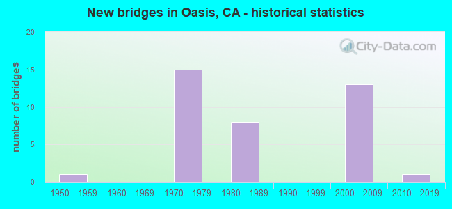
- New bridges - historical statistics
- 11950-1959
- 151970-1979
- 81980-1989
- 132000-2009
- 12010-2019


- Bridge Condition - Deck
- 90.9%Good
- 9.1%Fair

- Bridge Condition - Superstructure
- 90.9%Good
- 9.1%Fair

- Bridge Condition - Substructure
- 72.7%Good
- 27.3%Fair

- Bridge Condition - Channel
- 81.6%Very good
- 13.2%Good
- 5.3%Fair

- Bridge Condition - Culverts
- 80.0%Good
- 20.0%Satisfactory
Find on map >> Show street view
Structure Number: 56 0147L, Location: 08-RIV-086-2.01 (Lat: 33.448100, Lng: -116.082594), Route carried "on" structure: State highway 86, Year Built: 1989, Status: Open, Structure Length: 2.65m (8.69ft), Average Daily Traffic: 143,000 (year 2012), Truck Traffic: 27%, Average Future Daily Traffic: 177,936 (year 2038), Design Load: HS 20, Features Intersected: CALOTUS DITCH
Minimum Vertical Clearance: 30+ m (98+ ft), Kilometerpoint: 2.010, Lanes on structure: 2, Base Highway Network: Yes (, Subroute: 1), Owner: State Highway Agency, Approaching Roadway Width: 11.9m (39.0ft), Skew: 2 degrees, Material/Design: Concrete continuous, Design/Construction: Slab, Number Of Spans In Main Unit: 3, Length of Maximum Span: 10.4m (34.1ft), Curb-To-Curb Width: 11.9m (39.0ft), Out-to-Out Width: 12.5m (41.0ft)
Condition: Deck: Good, Superstructure: Good, Substructure: Good, Channel: Very good, Operating Rating: 54.1 metric tons, Method Used To Determine Operating Rating: Assigned rating based on Load Factor Design (LFD) reported in metric tons, Inventory Rating: 32.4 metric tons, Method Used To Determine Inventory Rating: Assigned rating based on Load Factor Design (LFD) reported in metric tons, Structural Evaluation: Better than present minimum criteria, Deck Geometry: Better than present minimum criteria, Waterway Adequacy: Equal to present desirable criteria, Approach Roadway Alignment: Equal to present desirable criteria, Designated Inspection Frequency: Every 24 months, Inspection Date: Febuary 2021, Deck Structure Type: Concrete Cast-file-Place
Find on map >> Show street view
Structure Number: 56 0147R, Location: 08-RIV-086-2.01 (Lat: 33.448372, Lng: -116.082439), Route carried "on" structure: State highway 86, Year Built: 1979, Status: Open, Structure Length: 2.62m (8.60ft), Average Daily Traffic: 143,000 (year 2012), Truck Traffic: 27%, Average Future Daily Traffic: 177,936 (year 2038), Design Load: HS 20, Features Intersected: CALOTUS DITCH
Minimum Vertical Clearance: 30+ m (98+ ft), Kilometerpoint: 2.010, Lanes on structure: 2, Base Highway Network: Yes (, Subroute: 1), Owner: State Highway Agency, Approaching Roadway Width: 12.2m (40.0ft), Skew: 2 degrees, Material/Design: Concrete continuous, Design/Construction: Slab, Number Of Spans In Main Unit: 3, Length of Maximum Span: 10.1m (33.1ft), Curb-To-Curb Width: 12.2m (40.0ft), Out-to-Out Width: 13.0m (42.7ft)
Condition: Deck: Good, Superstructure: Good, Substructure: Good, Channel: Very good, Operating Rating: 80.7 metric tons, Method Used To Determine Operating Rating: Load Factor (LF), Inventory Rating: 48.6 metric tons, Method Used To Determine Inventory Rating: Load Factor (LF), Structural Evaluation: Better than present minimum criteria, Deck Geometry: Better than present minimum criteria, Waterway Adequacy: Equal to present desirable criteria, Approach Roadway Alignment: Equal to present desirable criteria, Designated Inspection Frequency: Every 24 months, Inspection Date: Febuary 2021, Deck Structure Type: Concrete Cast-file-Place
Find on map >> Show street view
Structure Number: 56 0148L, Location: 08-RIV-086-1.82 (Lat: 33.445975, Lng: -116.080397), Route carried "on" structure: State highway 86, Year Built: 1989, Status: Open, Structure Length: 2.50m (8.20ft), Average Daily Traffic: 14,300 (year 2012), Truck Traffic: 27%, Average Future Daily Traffic: 17,794 (year 2038), Design Load: HS 20, Features Intersected: TURALA DITCH
Minimum Vertical Clearance: 30+ m (98+ ft), Kilometerpoint: 1.820, Lanes on structure: 2, Base Highway Network: Yes (, Subroute: 1), Owner: State Highway Agency, Approaching Roadway Width: 11.9m (39.0ft), Material/Design: Concrete continuous, Design/Construction: Slab, Number Of Spans In Main Unit: 3, Length of Maximum Span: 9.8m (32.2ft), Curb-To-Curb Width: 11.9m (39.0ft), Out-to-Out Width: 12.5m (41.0ft)
Condition: Deck: Good, Superstructure: Good, Substructure: Fair, Channel: Very good, Operating Rating: 54.1 metric tons, Method Used To Determine Operating Rating: Assigned rating based on Load Factor Design (LFD) reported in metric tons, Inventory Rating: 32.4 metric tons, Method Used To Determine Inventory Rating: Assigned rating based on Load Factor Design (LFD) reported in metric tons, Structural Evaluation: Somewhat better than minimum adequacy, Deck Geometry: Better than present minimum criteria, Waterway Adequacy: Equal to present desirable criteria, Approach Roadway Alignment: Equal to present desirable criteria, Designated Inspection Frequency: Every 24 months, Inspection Date: Febuary 2021, Deck Structure Type: Concrete Cast-file-Place
Find on map >> Show street view
Structure Number: 56 0148R, Location: 08-RIV-086-1.82 (Lat: 33.446147, Lng: -116.080169), Route carried "on" structure: State highway 86, Year Built: 1979, Status: Open, Structure Length: 2.53m (8.30ft), Average Daily Traffic: 14,300 (year 2012), Truck Traffic: 27%, Average Future Daily Traffic: 17,794 (year 2038), Design Load: HS 20, Features Intersected: TURALA DITCH
Minimum Vertical Clearance: 30+ m (98+ ft), Kilometerpoint: 1.820, Lanes on structure: 2, Base Highway Network: Yes (, Subroute: 1), Owner: State Highway Agency, Approaching Roadway Width: 12.2m (40.0ft), Material/Design: Concrete continuous, Design/Construction: Slab, Number Of Spans In Main Unit: 3, Length of Maximum Span: 9.8m (32.2ft), Curb-To-Curb Width: 12.2m (40.0ft), Out-to-Out Width: 13.0m (42.7ft)
Condition: Deck: Good, Superstructure: Good, Substructure: Good, Channel: Very good, Operating Rating: 80.7 metric tons, Method Used To Determine Operating Rating: Load Factor (LF), Inventory Rating: 48.6 metric tons, Method Used To Determine Inventory Rating: Load Factor (LF), Structural Evaluation: Better than present minimum criteria, Deck Geometry: Better than present minimum criteria, Waterway Adequacy: Equal to present desirable criteria, Approach Roadway Alignment: Equal to present desirable criteria, Designated Inspection Frequency: Every 24 months, Inspection Date: Febuary 2021, Deck Structure Type: Concrete Cast-file-Place
Find on map >> Show street view
Structure Number: 56 0149L, Location: 08-RIV-086-1.58 (Lat: 33.443400, Lng: -116.077664), Route carried "on" structure: State highway 86, Year Built: 1989, Status: Open, Structure Length: 1.68m (5.51ft), Average Daily Traffic: 14,300 (year 2012), Truck Traffic: 27%, Average Future Daily Traffic: 17,794 (year 2038), Design Load: HS 20, Features Intersected: MEMEL DITCH
Minimum Vertical Clearance: 30+ m (98+ ft), Kilometerpoint: 1.580, Lanes on structure: 2, Base Highway Network: Yes (, Subroute: 1), Owner: State Highway Agency, Approaching Roadway Width: 11.9m (39.0ft), Material/Design: Concrete continuous, Design/Construction: Slab, Number Of Spans In Main Unit: 2, Length of Maximum Span: 8.5m (27.9ft), Curb-To-Curb Width: 11.9m (39.0ft), Out-to-Out Width: 12.5m (41.0ft)
Condition: Deck: Good, Superstructure: Good, Substructure: Good, Channel: Very good, Operating Rating: 54.1 metric tons, Method Used To Determine Operating Rating: Assigned rating based on Load Factor Design (LFD) reported in metric tons, Inventory Rating: 32.4 metric tons, Method Used To Determine Inventory Rating: Assigned rating based on Load Factor Design (LFD) reported in metric tons, Structural Evaluation: Better than present minimum criteria, Deck Geometry: Better than present minimum criteria, Waterway Adequacy: Equal to present desirable criteria, Approach Roadway Alignment: Equal to present desirable criteria, Designated Inspection Frequency: Every 24 months, Inspection Date: Febuary 2021, Deck Structure Type: Concrete Cast-file-Place
Find on map >> Show street view
Structure Number: 56 0149R, Location: 08-RIV-086-1.58 (Lat: 33.443583, Lng: -116.077428), Route carried "on" structure: State highway 86, Year Built: 1979, Status: Open, Structure Length: 1.62m (5.31ft), Average Daily Traffic: 14,300 (year 2012), Truck Traffic: 27%, Average Future Daily Traffic: 17,794 (year 2038), Design Load: HS 20, Features Intersected: MEMEL DITCH
Minimum Vertical Clearance: 30+ m (98+ ft), Kilometerpoint: 1.580, Lanes on structure: 2, Base Highway Network: Yes (, Subroute: 1), Owner: State Highway Agency, Approaching Roadway Width: 12.2m (40.0ft), Material/Design: Concrete continuous, Design/Construction: Slab, Number Of Spans In Main Unit: 2, Length of Maximum Span: 7.6m (24.9ft), Curb-To-Curb Width: 12.2m (40.0ft), Out-to-Out Width: 13.0m (42.7ft)
Condition: Deck: Good, Superstructure: Good, Substructure: Good, Channel: Very good, Operating Rating: 90.4 metric tons, Method Used To Determine Operating Rating: Load Factor (LF), Inventory Rating: 54.4 metric tons, Method Used To Determine Inventory Rating: Load Factor (LF), Structural Evaluation: Better than present minimum criteria, Deck Geometry: Better than present minimum criteria, Waterway Adequacy: Better than present minimum criteria, Approach Roadway Alignment: Equal to present desirable criteria, Designated Inspection Frequency: Every 24 months, Inspection Date: Febuary 2021, Deck Structure Type: Concrete Cast-file-Place
Find on map >> Show street view
Structure Number: 56 0150L, Location: 08-RIV-086-1.38 (Lat: 33.441267, Lng: -116.075478), Route carried "on" structure: State highway 86, Year Built: 1989, Status: Open, Structure Length: 2.83m (9.28ft), Average Daily Traffic: 14,300 (year 2012), Truck Traffic: 27%, Average Future Daily Traffic: 17,794 (year 2038), Design Load: HS 20, Features Intersected: COPHY DITCH
Minimum Vertical Clearance: 30+ m (98+ ft), Kilometerpoint: 1.380, Lanes on structure: 2, Base Highway Network: Yes (, Subroute: 1), Owner: State Highway Agency, Approaching Roadway Width: 11.9m (39.0ft), Material/Design: Concrete continuous, Design/Construction: Slab, Number Of Spans In Main Unit: 4, Length of Maximum Span: 7.9m (25.9ft), Curb-To-Curb Width: 11.9m (39.0ft), Out-to-Out Width: 12.5m (41.0ft)
Condition: Deck: Good, Superstructure: Good, Substructure: Good, Channel: Very good, Operating Rating: 54.1 metric tons, Method Used To Determine Operating Rating: Assigned rating based on Load Factor Design (LFD) reported in metric tons, Inventory Rating: 32.4 metric tons, Method Used To Determine Inventory Rating: Assigned rating based on Load Factor Design (LFD) reported in metric tons, Structural Evaluation: Better than present minimum criteria, Deck Geometry: Better than present minimum criteria, Waterway Adequacy: Equal to present desirable criteria, Approach Roadway Alignment: Equal to present desirable criteria, Designated Inspection Frequency: Every 24 months, Inspection Date: Febuary 2021, Deck Structure Type: Concrete Cast-file-Place
Find on map >> Show street view
Structure Number: 56 0150R, Location: 08-RIV-086-1.39 (Lat: 33.441436, Lng: -116.075222), Route carried "on" structure: State highway 86, Year Built: 1979, Status: Open, Structure Length: 3.08m (10.10ft), Average Daily Traffic: 14,300 (year 2012), Truck Traffic: 27%, Average Future Daily Traffic: 17,794 (year 2038), Design Load: HS 20, Features Intersected: COPHY DITCH
Minimum Vertical Clearance: 30+ m (98+ ft), Kilometerpoint: 1.390, Lanes on structure: 2, Base Highway Network: Yes (, Subroute: 1), Owner: State Highway Agency, Approaching Roadway Width: 12.2m (40.0ft), Material/Design: Concrete continuous, Design/Construction: Slab, Number Of Spans In Main Unit: 4, Length of Maximum Span: 8.5m (27.9ft), Curb-To-Curb Width: 12.2m (40.0ft), Out-to-Out Width: 13.0m (42.7ft)
Condition: Deck: Good, Superstructure: Good, Substructure: Good, Channel: Very good, Operating Rating: 74.5 metric tons, Method Used To Determine Operating Rating: Load Factor (LF), Inventory Rating: 44.7 metric tons, Method Used To Determine Inventory Rating: Load Factor (LF), Structural Evaluation: Better than present minimum criteria, Deck Geometry: Better than present minimum criteria, Waterway Adequacy: Equal to present desirable criteria, Approach Roadway Alignment: Equal to present desirable criteria, Designated Inspection Frequency: Every 24 months, Inspection Date: Febuary 2021, Deck Structure Type: Concrete Cast-file-Place
Find on map >> Show street view
Structure Number: 56 0153L, Location: 08-RIV-086-0.99 (Lat: 33.436828, Lng: -116.070922), Route carried "on" structure: State highway 86, Year Built: 1989, Status: Open, Structure Length: 3.90m (12.80ft), Average Daily Traffic: 14,300 (year 2012), Truck Traffic: 27%, Average Future Daily Traffic: 17,794 (year 2038), Design Load: HS 20, Features Intersected: OTAN DITCH
Minimum Vertical Clearance: 30+ m (98+ ft), Kilometerpoint: 0.990, Lanes on structure: 2, Base Highway Network: Yes (, Subroute: 1), Owner: State Highway Agency, Approaching Roadway Width: 11.9m (39.0ft), Skew: 2 degrees, Material/Design: Concrete continuous, Design/Construction: Slab, Number Of Spans In Main Unit: 5, Length of Maximum Span: 8.5m (27.9ft), Curb-To-Curb Width: 11.9m (39.0ft), Out-to-Out Width: 12.5m (41.0ft)
Condition: Deck: Good, Superstructure: Good, Substructure: Good, Channel: Very good, Operating Rating: 54.1 metric tons, Method Used To Determine Operating Rating: Assigned rating based on Load Factor Design (LFD) reported in metric tons, Inventory Rating: 32.4 metric tons, Method Used To Determine Inventory Rating: Assigned rating based on Load Factor Design (LFD) reported in metric tons, Structural Evaluation: Better than present minimum criteria, Deck Geometry: Better than present minimum criteria, Waterway Adequacy: Equal to present desirable criteria, Approach Roadway Alignment: Equal to present desirable criteria, Designated Inspection Frequency: Every 24 months, Inspection Date: Febuary 2021, Deck Structure Type: Concrete Cast-file-Place
Find on map >> Show street view
Structure Number: 56 0153R, Location: 08-RIV-086-0.99 (Lat: 33.437083, Lng: -116.070756), Route carried "on" structure: State highway 86, Year Built: 1979, Status: Open, Structure Length: 3.81m (12.50ft), Average Daily Traffic: 14,300 (year 2012), Truck Traffic: 27%, Average Future Daily Traffic: 17,794 (year 2038), Design Load: HS 20, Features Intersected: OTAN DITCH
Minimum Vertical Clearance: 30+ m (98+ ft), Kilometerpoint: 0.990, Lanes on structure: 2, Base Highway Network: Yes (, Subroute: 1), Owner: State Highway Agency, Approaching Roadway Width: 12.2m (40.0ft), Skew: 2 degrees, Material/Design: Concrete continuous, Design/Construction: Slab, Number Of Spans In Main Unit: 5, Length of Maximum Span: 8.2m (26.9ft), Curb-To-Curb Width: 12.2m (40.0ft), Out-to-Out Width: 13.0m (42.7ft)
Condition: Deck: Good, Superstructure: Good, Substructure: Good, Channel: Very good, Operating Rating: 78.1 metric tons, Method Used To Determine Operating Rating: Load Factor (LF), Inventory Rating: 47.0 metric tons, Method Used To Determine Inventory Rating: Load Factor (LF), Structural Evaluation: Better than present minimum criteria, Deck Geometry: Better than present minimum criteria, Waterway Adequacy: Equal to present desirable criteria, Approach Roadway Alignment: Equal to present desirable criteria, Designated Inspection Frequency: Every 24 months, Inspection Date: Febuary 2021, Deck Structure Type: Concrete Cast-file-Place
Find on map >> Show street view
Structure Number: 56 0154L, Location: 08-RIV-086-0.84 (Lat: 33.435192, Lng: -116.069242), Route carried "on" structure: State highway 86, Year Built: 1989, Status: Open, Structure Length: 1.22m (4.00ft), Average Daily Traffic: 14,300 (year 2012), Truck Traffic: 27%, Average Future Daily Traffic: 17,794 (year 2038), Design Load: HS 20, Features Intersected: ANITA DITCH
Minimum Vertical Clearance: 30+ m (98+ ft), Kilometerpoint: 0.840, Lanes on structure: 2, Base Highway Network: Yes (, Subroute: 1), Owner: State Highway Agency, Approaching Roadway Width: 11.9m (39.0ft), Material/Design: Concrete, Design/Construction: Slab, Number Of Spans In Main Unit: 1, Length of Maximum Span: 11.6m (38.1ft), Curb-To-Curb Width: 11.9m (39.0ft), Out-to-Out Width: 12.5m (41.0ft)
Condition: Deck: Good, Superstructure: Good, Substructure: Fair, Channel: Very good, Operating Rating: 54.1 metric tons, Method Used To Determine Operating Rating: Assigned rating based on Load Factor Design (LFD) reported in metric tons, Inventory Rating: 32.4 metric tons, Method Used To Determine Inventory Rating: Assigned rating based on Load Factor Design (LFD) reported in metric tons, Structural Evaluation: Somewhat better than minimum adequacy, Deck Geometry: Better than present minimum criteria, Waterway Adequacy: Equal to present desirable criteria, Approach Roadway Alignment: Equal to present desirable criteria, Designated Inspection Frequency: Every 24 months, Inspection Date: Febuary 2021, Deck Structure Type: Concrete Cast-file-Place
Find on map >> Show street view
Structure Number: 56 0154R, Location: 08-RIV-086-0.84 (Lat: 33.435369, Lng: -116.068994), Route carried "on" structure: State highway 86, Year Built: 1979, Status: Open, Structure Length: 1.28m (4.20ft), Average Daily Traffic: 14,300 (year 2012), Truck Traffic: 27%, Average Future Daily Traffic: 17,794 (year 2038), Design Load: HS 20, Features Intersected: ANITA DITCH
Minimum Vertical Clearance: 30+ m (98+ ft), Kilometerpoint: 0.840, Lanes on structure: 2, Base Highway Network: Yes (, Subroute: 1), Owner: State Highway Agency, Approaching Roadway Width: 12.2m (40.0ft), Material/Design: Concrete, Design/Construction: Slab, Number Of Spans In Main Unit: 1, Length of Maximum Span: 12.8m (42.0ft), Curb-To-Curb Width: 12.2m (40.0ft), Out-to-Out Width: 13.0m (42.7ft)
Condition: Deck: Good, Superstructure: Good, Substructure: Fair, Channel: Very good, Operating Rating: 94.6 metric tons, Method Used To Determine Operating Rating: Load Factor (LF), Inventory Rating: 57.0 metric tons, Method Used To Determine Inventory Rating: Load Factor (LF), Structural Evaluation: Somewhat better than minimum adequacy, Deck Geometry: Better than present minimum criteria, Waterway Adequacy: Equal to present desirable criteria, Approach Roadway Alignment: Equal to present desirable criteria, Designated Inspection Frequency: Every 24 months, Inspection Date: Febuary 2021, Deck Structure Type: Concrete Cast-file-Place
Find on map >> Show street view
Structure Number: 56 0156L, Location: 08-RIV-086-0.66 (Lat: 33.433181, Lng: -116.067178), Route carried "on" structure: State highway 86, Year Built: 1989, Status: Open, Structure Length: 3.47m (11.38ft), Average Daily Traffic: 14,300 (year 2012), Truck Traffic: 27%, Average Future Daily Traffic: 17,794 (year 2038), Design Load: HS 20, Features Intersected: SUGINO DITCH
Minimum Vertical Clearance: 30+ m (98+ ft), Kilometerpoint: 0.660, Lanes on structure: 2, Base Highway Network: Yes (, Subroute: 1), Owner: State Highway Agency, Approaching Roadway Width: 11.9m (39.0ft), Skew: 2 degrees, Material/Design: Concrete continuous, Design/Construction: Slab, Number Of Spans In Main Unit: 4, Length of Maximum Span: 9.8m (32.2ft), Curb-To-Curb Width: 11.9m (39.0ft), Out-to-Out Width: 12.5m (41.0ft)
Condition: Deck: Good, Superstructure: Good, Substructure: Fair, Channel: Very good, Operating Rating: 54.1 metric tons, Method Used To Determine Operating Rating: Assigned rating based on Load Factor Design (LFD) reported in metric tons, Inventory Rating: 32.4 metric tons, Method Used To Determine Inventory Rating: Assigned rating based on Load Factor Design (LFD) reported in metric tons, Structural Evaluation: Somewhat better than minimum adequacy, Deck Geometry: Better than present minimum criteria, Waterway Adequacy: Equal to present desirable criteria, Approach Roadway Alignment: Equal to present desirable criteria, Designated Inspection Frequency: Every 24 months, Inspection Date: Febuary 2021, Deck Structure Type: Concrete Cast-file-Place
Find on map >> Show street view
Structure Number: 56 0156R, Location: 08-RIV-086-0.66 (Lat: 33.433394, Lng: -116.066961), Route carried "on" structure: State highway 86, Year Built: 1979, Status: Open, Structure Length: 3.08m (10.10ft), Average Daily Traffic: 14,300 (year 2012), Truck Traffic: 27%, Average Future Daily Traffic: 17,794 (year 2038), Design Load: HS 20, Features Intersected: SUGINO DITCH
Minimum Vertical Clearance: 30+ m (98+ ft), Kilometerpoint: 0.660, Lanes on structure: 2, Base Highway Network: Yes (, Subroute: 1), Owner: State Highway Agency, Approaching Roadway Width: 12.2m (40.0ft), Skew: 1 degrees, Material/Design: Concrete continuous, Design/Construction: Slab, Number Of Spans In Main Unit: 4, Length of Maximum Span: 8.5m (27.9ft), Curb-To-Curb Width: 12.2m (40.0ft), Out-to-Out Width: 13.0m (42.7ft)
Condition: Deck: Good, Superstructure: Good, Substructure: Good, Channel: Very good, Operating Rating: 74.5 metric tons, Method Used To Determine Operating Rating: Load Factor (LF), Inventory Rating: 44.7 metric tons, Method Used To Determine Inventory Rating: Load Factor (LF), Structural Evaluation: Better than present minimum criteria, Deck Geometry: Better than present minimum criteria, Waterway Adequacy: Equal to present desirable criteria, Approach Roadway Alignment: Equal to present desirable criteria, Designated Inspection Frequency: Every 24 months, Inspection Date: Febuary 2021, Deck Structure Type: Concrete Cast-file-Place, Wearing Surface/Protective System: Wearing Surface: Integral Concrete
Find on map >> Show street view
Structure Number: 56 0158L, Location: 08-RIV-086-0.52 (Lat: 33.431694, Lng: -116.065656), Route carried "on" structure: State highway 86, Year Built: 1989, Status: Open, Structure Length: 1.77m (5.81ft), Average Daily Traffic: 14,300 (year 2012), Truck Traffic: 27%, Average Future Daily Traffic: 17,794 (year 2038), Design Load: HS 20, Features Intersected: SOSTO DITCH
Minimum Vertical Clearance: 30+ m (98+ ft), Kilometerpoint: 0.520, Lanes on structure: 2, Base Highway Network: Yes (, Subroute: 1), Owner: State Highway Agency, Approaching Roadway Width: 11.9m (39.0ft), Material/Design: Concrete continuous, Design/Construction: Slab, Number Of Spans In Main Unit: 2, Length of Maximum Span: 8.5m (27.9ft), Curb-To-Curb Width: 11.9m (39.0ft), Out-to-Out Width: 12.5m (41.0ft)
Condition: Deck: Good, Superstructure: Good, Substructure: Fair, Channel: Very good, Operating Rating: 54.1 metric tons, Method Used To Determine Operating Rating: Assigned rating based on Load Factor Design (LFD) reported in metric tons, Inventory Rating: 32.4 metric tons, Method Used To Determine Inventory Rating: Assigned rating based on Load Factor Design (LFD) reported in metric tons, Structural Evaluation: Somewhat better than minimum adequacy, Deck Geometry: Better than present minimum criteria, Waterway Adequacy: Equal to present desirable criteria, Approach Roadway Alignment: Equal to present desirable criteria, Designated Inspection Frequency: Every 24 months, Inspection Date: Febuary 2021, Deck Structure Type: Concrete Cast-file-Place
Find on map >> Show street view
Structure Number: 56 0158R, Location: 08-RIV-086-0.52 (Lat: 33.431900, Lng: -116.065433), Route carried "on" structure: State highway 86, Year Built: 1979, Status: Open, Structure Length: 1.80m (5.91ft), Average Daily Traffic: 14,300 (year 2012), Truck Traffic: 27%, Average Future Daily Traffic: 17,794 (year 2038), Design Load: HS 20, Features Intersected: SOSTO DITCH
Minimum Vertical Clearance: 30+ m (98+ ft), Kilometerpoint: 0.520, Lanes on structure: 2, Base Highway Network: Yes (, Subroute: 1), Owner: State Highway Agency, Approaching Roadway Width: 12.2m (40.0ft), Skew: 1 degrees, Material/Design: Concrete continuous, Design/Construction: Slab, Number Of Spans In Main Unit: 2, Length of Maximum Span: 8.5m (27.9ft), Curb-To-Curb Width: 12.2m (40.0ft), Out-to-Out Width: 13.0m (42.7ft)
Condition: Deck: Good, Superstructure: Good, Substructure: Good, Channel: Very good, Operating Rating: 89.1 metric tons, Method Used To Determine Operating Rating: Load Factor (LF), Inventory Rating: 53.8 metric tons, Method Used To Determine Inventory Rating: Load Factor (LF), Structural Evaluation: Better than present minimum criteria, Deck Geometry: Better than present minimum criteria, Waterway Adequacy: Equal to present desirable criteria, Approach Roadway Alignment: Equal to present desirable criteria, Designated Inspection Frequency: Every 24 months, Inspection Date: Febuary 2021, Deck Structure Type: Concrete Cast-file-Place, Wearing Surface/Protective System: Wearing Surface: Integral Concrete
Find on map >> Show street view
Structure Number: 56 0774L, Location: 08-RIV-086-R2.79 (Lat: 33.453100, Lng: -116.087664), Route carried "on" structure: State highway 86, Year Built: 2001, Status: Open, Structure Length: 1.83m (6.00ft), Average Daily Traffic: 143,000 (year 2012), Truck Traffic: 14%, Average Future Daily Traffic: 177,936 (year 2038), Design Load: HS 20, Features Intersected: ARRIBA DITCH
Minimum Vertical Clearance: 30+ m (98+ ft), Kilometerpoint: 2.790, Lanes on structure: 2, Base Highway Network: Yes (Inventory Route: 8, Subroute: 1), Owner: State Highway Agency, Approaching Roadway Width: 11.9m (39.0ft), Skew: 9 degrees, Material/Design: Concrete continuous, Design/Construction: Slab, Number Of Spans In Main Unit: 2, Number Of Approach Spans: 2, Length of Maximum Span: 9.2m (30.2ft), Curb-To-Curb Width: 11.9m (39.0ft), Out-to-Out Width: 12.9m (42.3ft)
Condition: Deck: Good, Superstructure: Good, Substructure: Fair, Channel: Very good, Operating Rating: 54.1 metric tons, Method Used To Determine Operating Rating: Assigned rating based on Load Factor Design (LFD) reported in metric tons, Inventory Rating: 32.4 metric tons, Method Used To Determine Inventory Rating: Assigned rating based on Load Factor Design (LFD) reported in metric tons, Structural Evaluation: Somewhat better than minimum adequacy, Deck Geometry: Better than present minimum criteria, Waterway Adequacy: Equal to present desirable criteria, Approach Roadway Alignment: Equal to present minimum criteria, Designated Inspection Frequency: Every 24 months, Inspection Date: April 2021, Deck Structure Type: Concrete Cast-file-Place
Find on map >> Show street view
Structure Number: 56 0774R, Location: 08-RIV-086-R2.79 (Lat: 33.453336, Lng: -116.087464), Route carried "on" structure: State highway 86, Year Built: 2000, Status: Open, Structure Length: 1.83m (6.00ft), Average Daily Traffic: 14,800 (year 2012), Truck Traffic: 14%, Average Future Daily Traffic: 17,653 (year 2038), Design Load: HS 20, Features Intersected: ARRIBA DITCH
Minimum Vertical Clearance: 30+ m (98+ ft), Kilometerpoint: 2.790, Lanes on structure: 2, Base Highway Network: Yes (Inventory Route: 8, Subroute: 1), Owner: State Highway Agency, Approaching Roadway Width: 11.9m (39.0ft), Skew: 9 degrees, Material/Design: Concrete continuous, Design/Construction: Slab, Number Of Spans In Main Unit: 2, Number Of Approach Spans: 2, Length of Maximum Span: 9.2m (30.2ft), Curb-To-Curb Width: 11.9m (39.0ft), Out-to-Out Width: 12.9m (42.3ft)
Condition: Deck: Good, Superstructure: Good, Substructure: Good, Channel: Very good, Operating Rating: 54.1 metric tons, Method Used To Determine Operating Rating: Assigned rating based on Load Factor Design (LFD) reported in metric tons, Inventory Rating: 32.4 metric tons, Method Used To Determine Inventory Rating: Assigned rating based on Load Factor Design (LFD) reported in metric tons, Structural Evaluation: Better than present minimum criteria, Deck Geometry: Better than present minimum criteria, Waterway Adequacy: Equal to present desirable criteria, Approach Roadway Alignment: Equal to present desirable criteria, Designated Inspection Frequency: Every 24 months, Inspection Date: April 2021, Deck Structure Type: Concrete Cast-file-Place
Find on map >> Show street view
Structure Number: 56 0775L, Location: 08-RIV-086-R2.93 (Lat: 33.454872, Lng: -116.088983), Route carried "on" structure: State highway 86, Year Built: 2001, Status: Open, Structure Length: 1.83m (6.00ft), Average Daily Traffic: 14,800 (year 2012), Truck Traffic: 14%, Average Future Daily Traffic: 17,653 (year 2038), Design Load: HS 20, Features Intersected: NEVA DITCH
Minimum Vertical Clearance: 30+ m (98+ ft), Kilometerpoint: 2.930, Lanes on structure: 2, Base Highway Network: Yes (Inventory Route: 8, Subroute: 1), Owner: State Highway Agency, Approaching Roadway Width: 11.9m (39.0ft), Skew: 9 degrees, Material/Design: Concrete continuous, Design/Construction: Slab, Number Of Spans In Main Unit: 2, Number Of Approach Spans: 2, Length of Maximum Span: 9.2m (30.2ft), Curb-To-Curb Width: 11.9m (39.0ft), Out-to-Out Width: 13.0m (42.7ft)
Condition: Deck: Good, Superstructure: Good, Substructure: Good, Channel: Very good, Operating Rating: 54.1 metric tons, Method Used To Determine Operating Rating: Assigned rating based on Load Factor Design (LFD) reported in metric tons, Inventory Rating: 32.4 metric tons, Method Used To Determine Inventory Rating: Assigned rating based on Load Factor Design (LFD) reported in metric tons, Structural Evaluation: Better than present minimum criteria, Deck Geometry: Better than present minimum criteria, Waterway Adequacy: Equal to present desirable criteria, Approach Roadway Alignment: Equal to present desirable criteria, Designated Inspection Frequency: Every 24 months, Inspection Date: April 2021, Deck Structure Type: Concrete Cast-file-Place
Find on map >> Show street view
Structure Number: 56 0775R, Location: 08-RIV-086-R2.93 (Lat: 33.455067, Lng: -116.088761), Route carried "on" structure: State highway 86, Year Built: 2000, Status: Open, Structure Length: 1.83m (6.00ft), Average Daily Traffic: 14,800 (year 2012), Truck Traffic: 14%, Average Future Daily Traffic: 17,653 (year 2038), Design Load: HS 20, Features Intersected: NEVA DITCH
Minimum Vertical Clearance: 30+ m (98+ ft), Kilometerpoint: 2.930, Lanes on structure: 2, Base Highway Network: Yes (Inventory Route: 8, Subroute: 1), Owner: State Highway Agency, Approaching Roadway Width: 11.9m (39.0ft), Skew: 9 degrees, Material/Design: Concrete continuous, Design/Construction: Slab, Number Of Spans In Main Unit: 2, Number Of Approach Spans: 2, Length of Maximum Span: 9.2m (30.2ft), Curb-To-Curb Width: 11.9m (39.0ft), Out-to-Out Width: 13.0m (42.7ft)
Condition: Deck: Good, Superstructure: Good, Substructure: Good, Channel: Very good, Operating Rating: 54.1 metric tons, Method Used To Determine Operating Rating: Assigned rating based on Load Factor Design (LFD) reported in metric tons, Inventory Rating: 32.4 metric tons, Method Used To Determine Inventory Rating: Assigned rating based on Load Factor Design (LFD) reported in metric tons, Structural Evaluation: Better than present minimum criteria, Deck Geometry: Better than present minimum criteria, Waterway Adequacy: Equal to present desirable criteria, Approach Roadway Alignment: Equal to present desirable criteria, Designated Inspection Frequency: Every 24 months, Inspection Date: April 2021, Deck Structure Type: Concrete Cast-file-Place
Find on map >> Show street view
Structure Number: 56 0776L, Location: 08-RIV-086-R3.32 (Lat: 33.460086, Lng: -116.091228), Route carried "on" structure: State highway 86, Year Built: 2000, Status: Open, Structure Length: 2.13m (6.99ft), Average Daily Traffic: 14,300 (year 2012), Truck Traffic: 14%, Average Future Daily Traffic: 17,794 (year 2038), Design Load: HS 20, Features Intersected: LOWEN DITCH
Minimum Vertical Clearance: 30+ m (98+ ft), Kilometerpoint: 3.320, Lanes on structure: 2, Base Highway Network: Yes (Inventory Route: 8, Subroute: 1), Owner: State Highway Agency, Approaching Roadway Width: 11.9m (39.0ft), Skew: 9 degrees, Material/Design: Concrete continuous, Design/Construction: Slab, Number Of Spans In Main Unit: 2, Length of Maximum Span: 10.7m (35.1ft), Curb-To-Curb Width: 11.9m (39.0ft), Out-to-Out Width: 13.0m (42.7ft)
Condition: Deck: Good, Superstructure: Good, Substructure: Good, Channel: Very good, Operating Rating: 54.1 metric tons, Method Used To Determine Operating Rating: Assigned rating based on Load Factor Design (LFD) reported in metric tons, Inventory Rating: 32.4 metric tons, Method Used To Determine Inventory Rating: Assigned rating based on Load Factor Design (LFD) reported in metric tons, Structural Evaluation: Better than present minimum criteria, Deck Geometry: Better than present minimum criteria, Waterway Adequacy: Equal to present desirable criteria, Approach Roadway Alignment: Equal to present desirable criteria, Designated Inspection Frequency: Every 24 months, Inspection Date: April 2021, Deck Structure Type: Concrete Cast-file-Place
Find on map >> Show street view
Structure Number: 56 0776R, Location: 08-RIV-086-R3.32 (Lat: 33.460267, Lng: -116.090856), Route carried "on" structure: State highway 86, Year Built: 2000, Status: Open, Structure Length: 2.13m (6.99ft), Average Daily Traffic: 143,000 (year 2012), Truck Traffic: 14%, Average Future Daily Traffic: 177,936 (year 2038), Design Load: HS 20, Features Intersected: LOWEN DITCH
Minimum Vertical Clearance: 30+ m (98+ ft), Kilometerpoint: 3.320, Lanes on structure: 2, Base Highway Network: Yes (Inventory Route: 8, Subroute: 1), Owner: State Highway Agency, Approaching Roadway Width: 11.9m (39.0ft), Skew: 9 degrees, Material/Design: Concrete continuous, Design/Construction: Slab, Number Of Spans In Main Unit: 2, Length of Maximum Span: 10.7m (35.1ft), Curb-To-Curb Width: 11.9m (39.0ft), Out-to-Out Width: 13.0m (42.7ft)
Condition: Deck: Fair, Superstructure: Fair, Substructure: Good, Channel: Very good, Operating Rating: 54.1 metric tons, Method Used To Determine Operating Rating: Assigned rating based on Load Factor Design (LFD) reported in metric tons, Inventory Rating: 32.4 metric tons, Method Used To Determine Inventory Rating: Assigned rating based on Load Factor Design (LFD) reported in metric tons, Structural Evaluation: Somewhat better than minimum adequacy, Deck Geometry: Better than present minimum criteria, Waterway Adequacy: Equal to present desirable criteria, Approach Roadway Alignment: Equal to present desirable criteria, Length Of Structure Improvement: 2.13m (6.99ft), Designated Inspection Frequency: Every 24 months, Inspection Date: April 2021, Bridge Improvement Cost: $275,000, Roadway Improvement Cost: $55,000, Total Project Cost: $462,000 ( Estimate for 2020), Deck Structure Type: Concrete Cast-file-Place
Find on map >> Show street view
Structure Number: 56 0777L, Location: 08-RIV-086-R9.78 (Lat: 33.552633, Lng: -116.096186), Route carried "on" structure: State highway 86, Year Built: 2000, Status: Open, Structure Length: 25.70m (84.32ft), Average Daily Traffic: 143,000 (year 2012), Truck Traffic: 14%, Average Future Daily Traffic: 177,936 (year 2038), Design Load: HS 20+Mod, Features Intersected: WHITEWATER RIVER
Minimum Vertical Clearance: 30+ m (98+ ft), Kilometerpoint: 9.780, Lanes on structure: 2, Base Highway Network: Yes (Inventory Route: 8, Subroute: 1), Owner: State Highway Agency, Approaching Roadway Width: 11.9m (39.0ft), Skew: 19 degrees, Material/Design: Prestressed concrete continuous, Design/Construction: Box Beam or Girders - Multiple, Number Of Spans In Main Unit: 5, Length of Maximum Span: 57.3m (188.0ft), Curb-To-Curb Width: 11.9m (39.0ft), Out-to-Out Width: 12.0m (39.4ft)
Condition: Deck: Good, Superstructure: Good, Substructure: Good, Channel: Very good, Operating Rating: 54.1 metric tons, Method Used To Determine Operating Rating: Assigned rating based on Load Factor Design (LFD) reported in metric tons, Inventory Rating: 32.4 metric tons, Method Used To Determine Inventory Rating: Assigned rating based on Load Factor Design (LFD) reported in metric tons, Structural Evaluation: Better than present minimum criteria, Deck Geometry: Better than present minimum criteria, Waterway Adequacy: Equal to present desirable criteria, Approach Roadway Alignment: Equal to present desirable criteria, Designated Inspection Frequency: Every 24 months, Inspection Date: April 2021, Deck Structure Type: Concrete Cast-file-Place
Find on map >> Show street view
Structure Number: 56 0777R, Location: 08-RIV-086-R9.78 (Lat: 33.552389, Lng: -116.095878), Route carried "on" structure: State highway 86, Year Built: 2000, Status: Open, Structure Length: 24.90m (81.69ft), Average Daily Traffic: 143,000 (year 2012), Truck Traffic: 14%, Average Future Daily Traffic: 177,936 (year 2038), Design Load: HS 20+Mod, Features Intersected: WHITEWATER RIVER
Minimum Vertical Clearance: 30+ m (98+ ft), Kilometerpoint: 9.780, Lanes on structure: 2, Base Highway Network: Yes (Inventory Route: 8, Subroute: 1), Owner: State Highway Agency, Approaching Roadway Width: 11.9m (39.0ft), Skew: 9 degrees, Material/Design: Prestressed concrete continuous, Design/Construction: Box Beam or Girders - Multiple, Number Of Spans In Main Unit: 5, Length of Maximum Span: 55.5m (182.1ft), Curb-To-Curb Width: 11.9m (39.0ft), Out-to-Out Width: 12.7m (41.7ft)
Condition: Deck: Good, Superstructure: Good, Substructure: Fair, Channel: Very good, Operating Rating: 54.1 metric tons, Method Used To Determine Operating Rating: Assigned rating based on Load Factor Design (LFD) reported in metric tons, Inventory Rating: 32.4 metric tons, Method Used To Determine Inventory Rating: Assigned rating based on Load Factor Design (LFD) reported in metric tons, Structural Evaluation: Somewhat better than minimum adequacy, Deck Geometry: Better than present minimum criteria, Waterway Adequacy: Equal to present desirable criteria, Approach Roadway Alignment: Equal to present desirable criteria, Designated Inspection Frequency: Every 24 months, Inspection Date: April 2021, Deck Structure Type: Concrete Cast-file-Place
Find on map >> Show street view
Structure Number: 56 0778L, Location: 08-RIV-086-R4.74 (Lat: 33.480781, Lng: -116.091578), Route carried "on" structure: State highway 86, Year Built: 2000, Status: Open, Structure Length: 2.01m (6.59ft), Average Daily Traffic: 14,300 (year 2012), Truck Traffic: 27%, Average Future Daily Traffic: 17,794 (year 2038), Design Load: HS 20+Mod, Features Intersected: KINGS STORMWATER CHANNEL
Minimum Vertical Clearance: 30+ m (98+ ft), Kilometerpoint: 4.740, Lanes on structure: 2, Base Highway Network: Yes (, Subroute: 1), Owner: State Highway Agency, Approaching Roadway Width: 11.8m (38.7ft), Material/Design: Concrete continuous, Design/Construction: Slab, Number Of Spans In Main Unit: 2, Length of Maximum Span: 10.0m (32.8ft), Curb-To-Curb Width: 11.8m (38.7ft), Out-to-Out Width: 12.9m (42.3ft)
Condition: Deck: Good, Superstructure: Good, Substructure: Good, Channel: Fair, Operating Rating: 54.1 metric tons, Method Used To Determine Operating Rating: Assigned rating based on Load Factor Design (LFD) reported in metric tons, Inventory Rating: 32.4 metric tons, Method Used To Determine Inventory Rating: Assigned rating based on Load Factor Design (LFD) reported in metric tons, Structural Evaluation: Better than present minimum criteria, Deck Geometry: Better than present minimum criteria, Waterway Adequacy: Equal to present desirable criteria, Approach Roadway Alignment: Equal to present desirable criteria, Designated Inspection Frequency: Every 24 months, Inspection Date: April 2021, Deck Structure Type: Concrete Cast-file-Place
Find on map >> Show street view
Structure Number: 56 0779L, Location: 08-RIV-086-R5.99 (Lat: 33.498939, Lng: -116.091650), Route carried "on" structure: State highway 86, Year Built: 2000, Status: Open, Structure Length: 2.62m (8.60ft), Average Daily Traffic: 143,000 (year 2012), Truck Traffic: 14%, Average Future Daily Traffic: 177,936 (year 2038), Design Load: HS 20+Mod, Features Intersected: 76TH AVE DRAIN
Minimum Vertical Clearance: 30+ m (98+ ft), Kilometerpoint: 5.990, Lanes on structure: 4, Base Highway Network: Yes (Inventory Route: 8, Subroute: 1), Owner: State Highway Agency, Approaching Roadway Width: 15.5m (50.9ft), Skew: 9 degrees, Material/Design: Concrete continuous, Design/Construction: Culvert, Number Of Spans In Main Unit: 10, Length of Maximum Span: 2.4m (7.9ft)
Condition: Channel: Very good, Culverts: Good, Operating Rating: 54.1 metric tons, Method Used To Determine Operating Rating: Field evaluation and documented engineering judgment, Inventory Rating: 32.4 metric tons, Method Used To Determine Inventory Rating: Field evaluation and documented engineering judgment, Structural Evaluation: Better than present minimum criteria, Waterway Adequacy: Equal to present desirable criteria, Approach Roadway Alignment: Equal to present desirable criteria, Designated Inspection Frequency: Every 24 months, Inspection Date: April 2021
Find on map >> Show street view
Structure Number: 56 0779R, Location: 08-RIV-086-R5.99 (Lat: 33.498989, Lng: -116.091239), Route carried "on" structure: State highway 86, Year Built: 2000, Status: Open, Structure Length: 2.13m (6.99ft), Average Daily Traffic: 14,300 (year 2012), Truck Traffic: 14%, Average Future Daily Traffic: 17,794 (year 2038), Design Load: HS 20+Mod, Features Intersected: 76TH AVE DRAIN
Minimum Vertical Clearance: 30+ m (98+ ft), Kilometerpoint: 5.990, Lanes on structure: 2, Base Highway Network: Yes (Inventory Route: 8, Subroute: 1), Owner: State Highway Agency, Approaching Roadway Width: 12.0m (39.4ft), Skew: 9 degrees, Material/Design: Concrete, Design/Construction: Culvert, Number Of Spans In Main Unit: 10, Length of Maximum Span: 3.0m (9.8ft)
Condition: Channel: Very good, Culverts: Good, Operating Rating: 54.1 metric tons, Method Used To Determine Operating Rating: Field evaluation and documented engineering judgment, Inventory Rating: 32.4 metric tons, Method Used To Determine Inventory Rating: Field evaluation and documented engineering judgment, Structural Evaluation: Better than present minimum criteria, Waterway Adequacy: Equal to present desirable criteria, Approach Roadway Alignment: Equal to present desirable criteria, Designated Inspection Frequency: Every 24 months, Inspection Date: April 2021
Find on map >> Show street view
Structure Number: 56 0877R, Location: 08-RIV-086-R4.74 (Lat: 33.480772, Lng: -116.091203), Route carried "on" structure: State highway 86, Year Built: 2015, Status: Open, Structure Length: 2.01m (6.59ft), Average Daily Traffic: 143,000 (year 2012), Truck Traffic: 27%, Average Future Daily Traffic: 177,936 (year 2038), Design Load: HL 93, Features Intersected: KINGS STORMWATER CHANNEL
Minimum Vertical Clearance: 30+ m (98+ ft), Kilometerpoint: 4.740, Lanes on structure: 2, Base Highway Network: Yes (, Subroute: 1), Owner: State Highway Agency, Approaching Roadway Width: 11.9m (39.0ft), Material/Design: Prestressed concrete, Design/Construction: Slab, Number Of Spans In Main Unit: 1, Length of Maximum Span: 20.1m (65.9ft), Curb-To-Curb Width: 11.9m (39.0ft), Out-to-Out Width: 12.8m (42.0ft)
Condition: Deck: Good, Superstructure: Good, Substructure: Good, Channel: Fair, Operating Rating: 42.1 metric tons, Method Used To Determine Operating Rating: Assigned ratings based on Load and Resistance Factor Design (LRFD) reported by rating factor (RF) using HL93 loadings, Inventory Rating: 32.4 metric tons, Method Used To Determine Inventory Rating: Assigned ratings based on Load and Resistance Factor Design (LRFD) reported by rating factor (RF) using HL93 loadings, Structural Evaluation: Better than present minimum criteria, Deck Geometry: Better than present minimum criteria, Waterway Adequacy: Equal to present desirable criteria, Approach Roadway Alignment: Equal to present desirable criteria, Designated Inspection Frequency: Every 24 months, Inspection Date: April 2021, Deck Structure Type: Concrete Precast Panels, Wearing Surface/Protective System: Wearing Surface: Integral Concrete
Find on map >> Show street view
Structure Number: 56C0512, Location: MI 4.74 ON I86S (Lat: 33.480672, Lng: -116.091767), Route carried "on" structure: County highway , Year Built: 2002, Status: Open, Structure Length: 2.00m (6.56ft), Average Daily Traffic: 10 (year 2021), Truck Traffic: 10%, Average Future Daily Traffic: 20 (year 2039), Design Load: HS 20+Mod, Features Intersected: KINGS STORM WATER CHANNE, Facility Carried by Structure: WEST FRONTAGE RD#4
Minimum Vertical Clearance: 30+ m (98+ ft), Kilometerpoint: 0.000, Lanes on structure: 2, Owner: County Highway Agency, Approaching Roadway Width: 9.7m (31.8ft), Material/Design: Concrete continuous, Design/Construction: Slab, Number Of Spans In Main Unit: 2, Length of Maximum Span: 10.0m (32.8ft), Curb-To-Curb Width: 12.1m (39.7ft), Out-to-Out Width: 13.1m (43.0ft)
Condition: Deck: Good, Superstructure: Good, Substructure: Good, Channel: Good, Operating Rating: 54.1 metric tons, Method Used To Determine Operating Rating: Assigned rating based on Load Factor Design (LFD) reported in metric tons, Inventory Rating: 32.4 metric tons, Method Used To Determine Inventory Rating: Assigned rating based on Load Factor Design (LFD) reported in metric tons, Structural Evaluation: Better than present minimum criteria, Deck Geometry: Superior to present desirable criteria, Waterway Adequacy: Better than present minimum criteria, Approach Roadway Alignment: Superior to present desirable criteria, Designated Inspection Frequency: Every 48 months, Inspection Date: September 2021, Deck Structure Type: Concrete Cast-file-Place
Find on map >> Show street view
Structure Number: 56C0513, Location: MI 4.74 ON I86S (Lat: 33.480728, Lng: -116.090831), Route carried "on" structure: County highway , Year Built: 2002, Status: Open, Structure Length: 2.00m (6.56ft), Average Daily Traffic: 10 (year 2012), Truck Traffic: 20%, Average Future Daily Traffic: 20 (year 2038), Design Load: HS 20+Mod, Features Intersected: KINGS STORM WATER CHANNE, Facility Carried by Structure: E. FRONTAGE RD. #3
Minimum Vertical Clearance: 30+ m (98+ ft), Kilometerpoint: 0.000, Lanes on structure: 2, Owner: County Highway Agency, Approaching Roadway Width: 12.0m (39.4ft), Material/Design: Concrete continuous, Design/Construction: Slab, Number Of Spans In Main Unit: 2, Length of Maximum Span: 10.0m (32.8ft), Curb-To-Curb Width: 12.1m (39.7ft), Out-to-Out Width: 13.1m (43.0ft)
Condition: Deck: Good, Superstructure: Good, Substructure: Good, Channel: Good, Operating Rating: 54.1 metric tons, Method Used To Determine Operating Rating: Assigned rating based on Load Factor Design (LFD) reported in metric tons, Inventory Rating: 32.4 metric tons, Method Used To Determine Inventory Rating: Assigned rating based on Load Factor Design (LFD) reported in metric tons, Structural Evaluation: Better than present minimum criteria, Deck Geometry: Superior to present desirable criteria, Waterway Adequacy: Better than present minimum criteria, Approach Roadway Alignment: Superior to present desirable criteria, Designated Inspection Frequency: Every 24 months, Inspection Date: September 2021, Deck Structure Type: Concrete Cast-file-Place
Find on map >> Show street view
Structure Number: 56C0579, Location: 0.9 MI. W/O ST RTE 86S (Lat: 33.569275, Lng: -116.108542), Route carried "on" structure: County highway , Year Built: 1973, Status: Open, Structure Length: 1.31m (4.30ft), Average Daily Traffic: 3,765 (year 2016), Truck Traffic: 10%, Average Future Daily Traffic: 6,202 (year 2040), Design Load: HS 20, Features Intersected: WHITEWATER RIVER, Facility Carried by Structure: 66TH AVE
Minimum Vertical Clearance: 30+ m (98+ ft), Kilometerpoint: 0.000, Lanes on structure: 2, Owner: County Highway Agency, Approaching Roadway Width: 12.2m (40.0ft), Skew: 3 degrees, Material/Design: Concrete, Design/Construction: Slab, Number Of Spans In Main Unit: 1, Length of Maximum Span: 12.2m (40.0ft), Curb-To-Curb Width: 12.2m (40.0ft), Out-to-Out Width: 13.2m (43.3ft)
Condition: Deck: Good, Superstructure: Good, Substructure: Fair, Channel: Very good, Operating Rating: 99.8 metric tons, Method Used To Determine Operating Rating: Load Factor (LF), Inventory Rating: 63.5 metric tons, Method Used To Determine Inventory Rating: Load Factor (LF), Structural Evaluation: Somewhat better than minimum adequacy, Deck Geometry: Equal to present minimum criteria, Waterway Adequacy: Better than present minimum criteria, Approach Roadway Alignment: Better than present minimum criteria, Designated Inspection Frequency: Every 24 months, Inspection Date: March 2021, Deck Structure Type: Concrete Cast-file-Place, Wearing Surface/Protective System: Wearing Surface: Bituminous
Find on map >> Show street view
Structure Number: 56C0581, Location: 1.5 MI S/O AVE 66 (Lat: 33.549358, Lng: -116.158514), Route carried "on" structure: County highway , Year Built: 1976, Status: Open, Structure Length: 2.62m (8.60ft), Average Daily Traffic: 5,227 (year 2013), Truck Traffic: 1%, Average Future Daily Traffic: 6,000 (year 2040), Features Intersected: LENCHO DITCH, Facility Carried by Structure: HARRISON ST
Minimum Vertical Clearance: 30+ m (98+ ft), Kilometerpoint: 0.000, Lanes on structure: 3, Owner: County Highway Agency, Approaching Roadway Width: 20.4m (66.9ft), Material/Design: Concrete, Design/Construction: Culvert, Number Of Spans In Main Unit: 10, Length of Maximum Span: 2.4m (7.9ft), Curb-To-Curb Width: 20.4m (66.9ft), Out-to-Out Width: 22.3m (73.2ft)
Condition: Channel: Good, Culverts: Good, Operating Rating: 54.1 metric tons, Method Used To Determine Operating Rating: Field evaluation and documented engineering judgment, Inventory Rating: 32.4 metric tons, Method Used To Determine Inventory Rating: Field evaluation and documented engineering judgment, Structural Evaluation: Better than present minimum criteria, Deck Geometry: Superior to present desirable criteria, Waterway Adequacy: Better than present minimum criteria, Approach Roadway Alignment: Equal to present desirable criteria, Designated Inspection Frequency: Every 48 months, Inspection Date: March 2021
Find on map >> Show street view
Structure Number: 56C0582, Location: 6 MI S/O AVE 66 (Lat: 33.499050, Lng: -116.119328), Route carried "on" structure: County highway , Year Built: 1972, Status: Open, Structure Length: 1.28m (4.20ft), Average Daily Traffic: 1,500 (year 2012), Truck Traffic: 1%, Average Future Daily Traffic: 2,000 (year 2040), Features Intersected: SOLO DITCH, Facility Carried by Structure: HARRISON ST
Minimum Vertical Clearance: 30+ m (98+ ft), Kilometerpoint: 0.000, Lanes on structure: 3, Owner: County Highway Agency, Approaching Roadway Width: 12.2m (40.0ft), Skew: 3 degrees, Material/Design: Concrete, Design/Construction: Culvert, Number Of Spans In Main Unit: 3, Length of Maximum Span: 4.6m (15.1ft), Curb-To-Curb Width: 12.2m (40.0ft), Out-to-Out Width: 16.4m (53.8ft)
Condition: Channel: Good, Culverts: Satisfactory, Operating Rating: 54.1 metric tons, Method Used To Determine Operating Rating: Field evaluation and documented engineering judgment, Inventory Rating: 32.4 metric tons, Method Used To Determine Inventory Rating: Field evaluation and documented engineering judgment, Structural Evaluation: Equal to present minimum criteria, Deck Geometry: Meets minimum limits, Waterway Adequacy: Better than present minimum criteria, Approach Roadway Alignment: Equal to present desirable criteria, Designated Inspection Frequency: Every 48 months, Inspection Date: March 2021
Find on map >> Show street view
Structure Number: 56C0583, Location: 0.8 MI S/O PIERCE ST (Lat: 33.478742, Lng: -116.111175), Route carried "on" structure: County highway , Year Built: 1976, Status: Open, Structure Length: 2.62m (8.60ft), Average Daily Traffic: 1,000 (year 2012), Truck Traffic: 1%, Average Future Daily Traffic: 1,200 (year 2040), Design Load: HS 20, Features Intersected: LOFTUS DITCH, Facility Carried by Structure: HARRISON ST
Minimum Vertical Clearance: 30+ m (98+ ft), Kilometerpoint: 0.000, Lanes on structure: 2, Owner: County Highway Agency, Approaching Roadway Width: 12.2m (40.0ft), Skew: 1 degrees, Material/Design: Concrete continuous, Design/Construction: Slab, Number Of Spans In Main Unit: 3, Length of Maximum Span: 8.5m (27.9ft), Curb-To-Curb Width: 12.2m (40.0ft), Out-to-Out Width: 13.0m (42.7ft)
Condition: Deck: Good, Superstructure: Good, Substructure: Good, Channel: Very good, Operating Rating: 65.8 metric tons, Method Used To Determine Operating Rating: Load Factor (LF), Inventory Rating: 39.5 metric tons, Method Used To Determine Inventory Rating: Load Factor (LF), Structural Evaluation: Better than present minimum criteria, Deck Geometry: Equal to present desirable criteria, Waterway Adequacy: Equal to present desirable criteria, Approach Roadway Alignment: Better than present minimum criteria, Designated Inspection Frequency: Every 48 months, Inspection Date: March 2021, Deck Structure Type: Concrete Cast-file-Place, Wearing Surface/Protective System: Wearing Surface: Bituminous
Find on map >> Show street view
Structure Number: 56C0584, Location: 1.3 MI S/O PIERCE ST (Lat: 33.473881, Lng: -116.107406), Route carried "on" structure: County highway , Year Built: 1950, Year Reconstructed: 1989, Status: Open, Structure Length: 2.96m (9.71ft), Average Daily Traffic: 1,000 (year 2012), Truck Traffic: 1%, Average Future Daily Traffic: 1,200 (year 2040), Design Load: HS 20, Features Intersected: ALMAR DITCH, Facility Carried by Structure: HARRISON ST
Minimum Vertical Clearance: 30+ m (98+ ft), Kilometerpoint: 0.000, Lanes on structure: 2, Owner: County Highway Agency, Approaching Roadway Width: 12.2m (40.0ft), Material/Design: Concrete continuous, Design/Construction: Slab, Number Of Spans In Main Unit: 5, Length of Maximum Span: 5.8m (19.0ft), Curb-To-Curb Width: 12.2m (40.0ft), Out-to-Out Width: 12.8m (42.0ft)
Condition: Deck: Good, Superstructure: Good, Substructure: Fair, Channel: Good, Operating Rating: 54.1 metric tons, Method Used To Determine Operating Rating: Assigned rating based on Load Factor Design (LFD) reported in metric tons, Inventory Rating: 32.4 metric tons, Method Used To Determine Inventory Rating: Assigned rating based on Load Factor Design (LFD) reported in metric tons, Structural Evaluation: Somewhat better than minimum adequacy, Deck Geometry: Equal to present desirable criteria, Waterway Adequacy: Better than present minimum criteria, Approach Roadway Alignment: Equal to present desirable criteria, Designated Inspection Frequency: Every 24 months, Inspection Date: March 2021, Deck Structure Type: Concrete Cast-file-Place, Wearing Surface/Protective System: Wearing Surface: Bituminous
Find on map >> Show street view
Structure Number: 56C0585, Location: 1.7 MI S/O PIERCE ST (Lat: 33.468294, Lng: -116.102911), Route carried "on" structure: County highway , Year Built: 1976, Status: Open, Structure Length: 1.58m (5.18ft), Average Daily Traffic: 1,000 (year 2012), Truck Traffic: 1%, Average Future Daily Traffic: 1,200 (year 2040), Features Intersected: LUNDY DITCH, Facility Carried by Structure: HARRISON ST
Minimum Vertical Clearance: 30+ m (98+ ft), Kilometerpoint: 0.000, Lanes on structure: 2, Owner: County Highway Agency, Approaching Roadway Width: 12.2m (40.0ft), Skew: 2 degrees, Material/Design: Concrete, Design/Construction: Culvert, Number Of Spans In Main Unit: 6, Length of Maximum Span: 2.7m (8.9ft)
Condition: Channel: Very good, Culverts: Good, Operating Rating: 54.1 metric tons, Method Used To Determine Operating Rating: Field evaluation and documented engineering judgment, Inventory Rating: 32.4 metric tons, Method Used To Determine Inventory Rating: Field evaluation and documented engineering judgment, Structural Evaluation: Better than present minimum criteria, Waterway Adequacy: Equal to present desirable criteria, Approach Roadway Alignment: Equal to present desirable criteria, Designated Inspection Frequency: Every 48 months, Inspection Date: March 2021
Find on map >> Show street view
Structure Number: 56C0586, Location: 0.2 MI S/ 81 ST AVENUE (Lat: 33.459931, Lng: -116.094222), Route carried "on" structure: County highway , Year Built: 1979, Status: Open, Structure Length: 2.38m (7.81ft), Average Daily Traffic: 100 (year 2019), Truck Traffic: 1%, Average Future Daily Traffic: 116 (year 2038), Design Load: HS 20, Features Intersected: LOWEN DITCH, Facility Carried by Structure: HARRISON ST
Minimum Vertical Clearance: 30+ m (98+ ft), Kilometerpoint: 0.000, Lanes on structure: 2, Base Highway Network: Yes, Owner: County Highway Agency, Approaching Roadway Width: 12.2m (40.0ft), Skew: 3 degrees, Material/Design: Concrete continuous, Design/Construction: Slab, Number Of Spans In Main Unit: 3, Length of Maximum Span: 9.1m (29.9ft), Curb-To-Curb Width: 12.2m (40.0ft), Out-to-Out Width: 13.0m (42.7ft)
Condition: Deck: Fair, Superstructure: Fair, Substructure: Good, Channel: Very good, Operating Rating: 82.9 metric tons, Method Used To Determine Operating Rating: Load Factor (LF), Inventory Rating: 49.9 metric tons, Method Used To Determine Inventory Rating: Load Factor (LF), Structural Evaluation: Somewhat better than minimum adequacy, Deck Geometry: Superior to present desirable criteria, Waterway Adequacy: Equal to present desirable criteria, Approach Roadway Alignment: Equal to present desirable criteria, Designated Inspection Frequency: Every 24 months, Inspection Date: September 2021, Deck Structure Type: Concrete Cast-file-Place
Find on map >> Show street view
Structure Number: 56C0587, Location: 0.3 MI S/ 81 ST AVENUE (Lat: 33.458822, Lng: -116.093106), Route carried "on" structure: County highway , Year Built: 1979, Status: Open, Structure Length: 2.62m (8.60ft), Average Daily Traffic: 100 (year 2019), Truck Traffic: 1%, Average Future Daily Traffic: 116 (year 2039), Design Load: HS 20, Features Intersected: VICO DITCH, Facility Carried by Structure: HARRISON ST
Minimum Vertical Clearance: 30+ m (98+ ft), Kilometerpoint: 0.000, Lanes on structure: 2, Base Highway Network: Yes, Owner: County Highway Agency, Approaching Roadway Width: 12.2m (40.0ft), Skew: 1 degrees, Material/Design: Concrete continuous, Design/Construction: Slab, Number Of Spans In Main Unit: 3, Length of Maximum Span: 10.1m (33.1ft), Curb-To-Curb Width: 12.2m (40.0ft), Out-to-Out Width: 13.0m (42.7ft)
Condition: Deck: Fair, Superstructure: Fair, Substructure: Good, Channel: Very good, Operating Rating: 80.7 metric tons, Method Used To Determine Operating Rating: Load Factor (LF), Inventory Rating: 48.6 metric tons, Method Used To Determine Inventory Rating: Load Factor (LF), Structural Evaluation: Somewhat better than minimum adequacy, Deck Geometry: Superior to present desirable criteria, Waterway Adequacy: Equal to present desirable criteria, Approach Roadway Alignment: Equal to present desirable criteria, Designated Inspection Frequency: Every 24 months, Inspection Date: September 2021, Deck Structure Type: Concrete Cast-file-Place