Bridge Statistics for Pepper Pike, Ohio (OH)
Condition, Traffic, Stress, Structural Evaluation, Project Costs
- National Bridge Inventory (NBI) Statistics
- 21Number of bridges
- 167ft / 50.6mTotal length
- $2,500,000Total costs
- 776,224Total average daily traffic
- 67,041Total average daily truck traffic
- National Bridge Inventory (NBI) Registered Bridges for Pepper Pike
- No street view available for this location
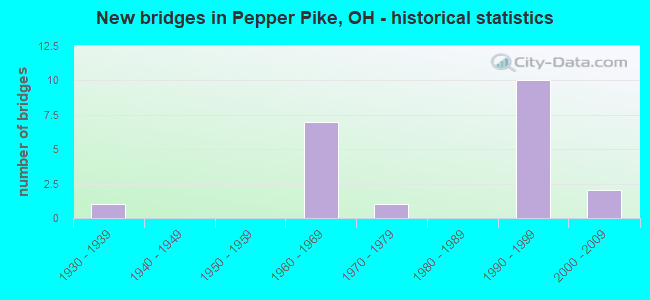
- New bridges - historical statistics
- 11930-1939
- 71960-1969
- 11970-1979
- 101990-1999
- 22000-2009

- Reconstructed bridges - Historical Statistics
- 11990-1999
- 12000-2009
- 12010-2019


- Bridge Condition - Deck
- 27.3%Very good
- 63.6%Good
- 9.1%Satisfactory

- Bridge Condition - Superstructure
- 45.5%Very good
- 36.4%Good
- 18.2%Satisfactory

- Bridge Condition - Substructure
- 45.5%Very good
- 36.4%Good
- 9.1%Satisfactory
- 9.1%Fair

- Bridge Condition - Channel
- 16.7%Very good
- 33.3%Good
- 50.0%Satisfactory

- Bridge Condition - Culverts
- 50.0%Satisfactory
- 50.0%Fair
Find on map >> Show street view
Structure Number: 1809482, Location: .24 MI N SR87 (Lat: 41.463561, Lng: -81.438339), Route carried "on" structure: State highway 91, Year Built: 1931, Year Reconstructed: 2007, Status: Open, Structure Length: 0.76m (2.49ft), Average Daily Traffic: 7,765 (year 2015), Truck Traffic: 4%, Average Future Daily Traffic: 10,778 (year 2035), Design Load: H 15, Features Intersected: STREAM 0.24 MI. N. OF 87
Minimum Vertical Clearance: 30+ m (98+ ft), Kilometerpoint: 12.923, Lanes on structure: 2, Owner: State Highway Agency, Approaching Roadway Width: 9.1m (29.9ft), Material/Design: Concrete, Design/Construction: Slab, Number Of Spans In Main Unit: 1, Length of Maximum Span: 4.9m (16.1ft), Curb-To-Curb Width: 9.2m (30.2ft), Out-to-Out Width: 9.4m (30.8ft)
Condition: Deck: Good, Superstructure: Good, Substructure: Fair, Channel: Satisfactory, Operating Rating: 42.1 metric tons, Method Used To Determine Operating Rating: Load Factor (LF) rating reported by rating factor (RF) method using MS18 loading, Inventory Rating: 32.4 metric tons, Method Used To Determine Inventory Rating: Load Factor (LF) rating reported by rating factor (RF) method using MS18 loading, Structural Evaluation: Somewhat better than minimum adequacy, Deck Geometry: High priority of corrective action, Waterway Adequacy: Equal to present minimum criteria, Approach Roadway Alignment: Equal to present minimum criteria, Designated Inspection Frequency: Every 12 months, Inspection Date: September 2021, Deck Structure Type: Concrete Cast-file-Place, Wearing Surface/Protective System: Wearing Surface: Monolithic Concrete, Deck Protection: Epoxy Coated Reinforcing
Find on map >> Show street view
Structure Number: 1809504, Location: .5 MI S SHAKER BLVD (Lat: 41.471061, Lng: -81.438189), Route carried "on" structure: State highway 91, Year Built: 1978, Year Reconstructed: 2016, Status: Open, Structure Length: 2.03m (6.66ft), Average Daily Traffic: 7,765 (year 2015), Truck Traffic: 4%, Average Future Daily Traffic: 10,778 (year 2038), Design Load: HS 20, Features Intersected: STREAM .76 MI N OF SR 87
Minimum Vertical Clearance: 30+ m (98+ ft), Kilometerpoint: 13.760, Lanes on structure: 2, Base Highway Network: Yes, Owner: State Highway Agency, Approaching Roadway Width: 11.4m (37.4ft), Skew: 3 degrees, Material/Design: Prestressed concrete, Design/Construction: Box Beam or Girders - Multiple, Number Of Spans In Main Unit: 1, Length of Maximum Span: 19.8m (65.0ft), Curb-To-Curb Width: 11.4m (37.4ft), Out-to-Out Width: 12.3m (40.4ft)
Condition: Deck: Very good, Superstructure: Very good, Substructure: Very good, Channel: Very good, Operating Rating: 77.8 metric tons, Method Used To Determine Operating Rating: Load Factor (LF) rating reported by rating factor (RF) method using MS18 loading, Inventory Rating: 46.7 metric tons, Method Used To Determine Inventory Rating: Load Factor (LF) rating reported by rating factor (RF) method using MS18 loading, Structural Evaluation: Equal to present desirable criteria, Deck Geometry: Meets minimum limits, Waterway Adequacy: Equal to present desirable criteria, Approach Roadway Alignment: Equal to present desirable criteria, Designated Inspection Frequency: Every 24 months, Inspection Date: September 2021, Deck Structure Type: Other, Wearing Surface/Protective System: Wearing Surface: Monolithic Concrete
Find on map >> Show street view
Structure Number: 1811312, Location: .72 MI. N. OF JCT. US-422 (Lat: 41.473419, Lng: -81.488139), Route carried "on" structure: Interstate 271, Year Built: 1962, Status: Open, Structure Length: 5.09m (16.70ft), Average Daily Traffic: 79,851 (year 2015), Truck Traffic: 9%, Average Future Daily Traffic: 110,833 (year 2035), Design Load: HS 20+Mod, Features Intersected: CR 21 (S. WOODLAND RD)
Minimum Vertical Clearance: 30+ m (98+ ft), Kilometerpoint: 14.243, Lanes on structure: 3, Lanes under structure: 2, Base Highway Network: Yes, Owner: State Highway Agency, Approaching Roadway Width: 17.1m (56.1ft), Material/Design: Steel continuous, Design/Construction: Stringer/Multi-beam, Number Of Spans In Main Unit: 3, Length of Maximum Span: 20.1m (65.9ft), Curb-To-Curb Width: 16.5m (54.1ft), Out-to-Out Width: 17.2m (56.4ft)
Condition: Deck: Good, Superstructure: Good, Substructure: Good, Operating Rating: 71.3 metric tons, Method Used To Determine Operating Rating: Load and Resistance Factor Rating (LRFR) rating reported by rating factor(RF) method using HL-93 loadings, Inventory Rating: 55.1 metric tons, Method Used To Determine Inventory Rating: Load and Resistance Factor Rating (LRFR) rating reported by rating factor(RF) method using HL-93 loadings, Structural Evaluation: Better than present minimum criteria, Deck Geometry: Equal to present minimum criteria, Underclear: Superior to present desirable criteria, Approach Roadway Alignment: Equal to present desirable criteria, Designated Inspection Frequency: Every 24 months, Inspection Date: March 2021, Deck Structure Type: Concrete Cast-file-Place, Wearing Surface/Protective System: Wearing Surface: Monolithic Concrete
Find on map >> Show street view
Structure Number: 181132, Location: .7 MI N OF I-271 & US-422 (Lat: 41.473419, Lng: -81.488511), Route carried "on" structure: Interstate 271X, Year Built: 1995, Status: Open, Structure Length: 4.94m (16.21ft), Average Daily Traffic: 79,851 (year 2015), Truck Traffic: 9%, Average Future Daily Traffic: 110,833 (year 2035), Design Load: HS 20+Mod, Features Intersected: SOUTH WOODLAND ROAD
Minimum Vertical Clearance: 30+ m (98+ ft), Kilometerpoint: 14.243, Lanes on structure: 2, Lanes under structure: 2, Base Highway Network: Yes, Owner: State Highway Agency, Approaching Roadway Width: 14.9m (48.9ft), Skew: 10 degrees, Material/Design: Steel continuous, Design/Construction: Stringer/Multi-beam, Number Of Spans In Main Unit: 3, Length of Maximum Span: 20.1m (65.9ft), Curb-To-Curb Width: 14.9m (48.9ft), Out-to-Out Width: 15.9m (52.2ft)
Condition: Deck: Very good, Superstructure: Very good, Substructure: Very good, Operating Rating: 35.6 metric tons, Method Used To Determine Operating Rating: Load and Resistance Factor Rating (LRFR) rating reported by rating factor(RF) method using HL-93 loadings, Inventory Rating: 25.9 metric tons, Method Used To Determine Inventory Rating: Load and Resistance Factor Rating (LRFR) rating reported by rating factor(RF) method using HL-93 loadings, Structural Evaluation: Equal to present minimum criteria, Deck Geometry: Superior to present desirable criteria, Underclear: High priority of corrective action, Approach Roadway Alignment: Equal to present desirable criteria, Designated Inspection Frequency: Every 24 months, Inspection Date: March 2021, Deck Structure Type: Concrete Cast-file-Place, Wearing Surface/Protective System: Wearing Surface: Monolithic Concrete, Deck Protection: Epoxy Coated Reinforcing
Find on map >> Show street view
Structure Number: 1811371, Location: 1.03 MI. N. OF JCT US-422 (Lat: 41.477761, Lng: -81.487311), Route carried "on" structure: Interstate 271, Year Built: 1962, Year Reconstructed: 1995, Status: Open, Structure Length: 3.90m (12.80ft), Average Daily Traffic: 79,851 (year 2015), Truck Traffic: 9%, Average Future Daily Traffic: 110,833 (year 2035), Design Load: HS 20+Mod, Features Intersected: SHAKER BLVD EB (CR13A)
Minimum Vertical Clearance: 30+ m (98+ ft), Kilometerpoint: 14.742, Lanes on structure: 3, Lanes under structure: 2, Base Highway Network: Yes, Owner: State Highway Agency, Approaching Roadway Width: 18.3m (60.0ft), Material/Design: Steel continuous, Design/Construction: Stringer/Multi-beam, Number Of Spans In Main Unit: 3, Length of Maximum Span: 17.7m (58.1ft), Curb-To-Curb Width: 18.3m (60.0ft), Out-to-Out Width: 19.4m (63.6ft)
Condition: Deck: Good, Superstructure: Very good, Substructure: Good, Operating Rating: 42.1 metric tons, Method Used To Determine Operating Rating: Load Factor (LF) rating reported by rating factor (RF) method using MS18 loading, Inventory Rating: 32.4 metric tons, Method Used To Determine Inventory Rating: Load Factor (LF) rating reported by rating factor (RF) method using MS18 loading, Structural Evaluation: Better than present minimum criteria, Deck Geometry: Better than present minimum criteria, Underclear: High priority of corrective action, Approach Roadway Alignment: Equal to present desirable criteria, Designated Inspection Frequency: Every 24 months, Inspection Date: March 2021, Deck Structure Type: Concrete Cast-file-Place, Wearing Surface/Protective System: Wearing Surface: Monolithic Concrete, Deck Protection: Epoxy Coated Reinforcing
Find on map >> Show street view
Structure Number: 1811398, Location: 1 MI N OF I-271 & US-422 (Lat: 41.477750, Lng: -81.487611), Route carried "on" structure: Interstate 271X, Year Built: 1995, Status: Open, Structure Length: 3.96m (12.99ft), Average Daily Traffic: 79,851 (year 2015), Truck Traffic: 9%, Average Future Daily Traffic: 110,833 (year 2035), Design Load: HS 20+Mod, Features Intersected: SHAKER BLVD EB (CR13A)
Minimum Vertical Clearance: 30+ m (98+ ft), Kilometerpoint: 14.742, Lanes on structure: 2, Lanes under structure: 2, Base Highway Network: Yes, Owner: State Highway Agency, Approaching Roadway Width: 14.9m (48.9ft), Material/Design: Steel continuous, Design/Construction: Stringer/Multi-beam, Number Of Spans In Main Unit: 3, Length of Maximum Span: 17.7m (58.1ft), Curb-To-Curb Width: 14.9m (48.9ft), Out-to-Out Width: 15.9m (52.2ft)
Condition: Deck: Good, Superstructure: Very good, Substructure: Very good, Operating Rating: 42.1 metric tons, Method Used To Determine Operating Rating: Load Factor (LF) rating reported by rating factor (RF) method using MS18 loading, Inventory Rating: 32.4 metric tons, Method Used To Determine Inventory Rating: Load Factor (LF) rating reported by rating factor (RF) method using MS18 loading, Structural Evaluation: Equal to present desirable criteria, Deck Geometry: Superior to present desirable criteria, Underclear: High priority of corrective action, Approach Roadway Alignment: Equal to present desirable criteria, Designated Inspection Frequency: Every 24 months, Inspection Date: March 2021, Deck Structure Type: Concrete Cast-file-Place, Wearing Surface/Protective System: Wearing Surface: Monolithic Concrete, Deck Protection: Epoxy Coated Reinforcing
Find on map >> Show street view
Structure Number: 1811444, Location: 1.1 MI N OF 1-271 & US422 (Lat: 41.479169, Lng: -81.487019), Route carried "on" structure: Interstate 271, Year Built: 1995, Status: Open, Structure Length: 3.90m (12.80ft), Average Daily Traffic: 79,851 (year 2015), Truck Traffic: 9%, Average Future Daily Traffic: 110,833 (year 2035), Design Load: HS 20+Mod, Features Intersected: SHAKER BLVD W.B.
Minimum Vertical Clearance: 30+ m (98+ ft), Kilometerpoint: 14.903, Lanes on structure: 3, Lanes under structure: 2, Base Highway Network: Yes, Owner: State Highway Agency, Approaching Roadway Width: 17.1m (56.1ft), Skew: 10 degrees, Material/Design: Steel continuous, Design/Construction: Stringer/Multi-beam, Number Of Spans In Main Unit: 3, Length of Maximum Span: 17.7m (58.1ft), Curb-To-Curb Width: 18.3m (60.0ft), Out-to-Out Width: 19.4m (63.6ft)
Condition: Deck: Good, Superstructure: Good, Substructure: Good, Operating Rating: 77.8 metric tons, Method Used To Determine Operating Rating: Load and Resistance Factor Rating (LRFR) rating reported by rating factor(RF) method using HL-93 loadings, Inventory Rating: 58.3 metric tons, Method Used To Determine Inventory Rating: Load and Resistance Factor Rating (LRFR) rating reported by rating factor(RF) method using HL-93 loadings, Structural Evaluation: Better than present minimum criteria, Deck Geometry: Better than present minimum criteria, Underclear: High priority of corrective action, Approach Roadway Alignment: Equal to present desirable criteria, Designated Inspection Frequency: Every 24 months, Inspection Date: Febuary 2021, Deck Structure Type: Concrete Cast-file-Place, Wearing Surface/Protective System: Wearing Surface: Monolithic Concrete, Deck Protection: Epoxy Coated Reinforcing
Find on map >> Show street view
Structure Number: 181146, Location: 2.29 MI. S. OF JCT US-322 (Lat: 41.501231, Lng: -81.481669), Route carried "on" structure: County highway C0023, Year Built: 1963, Status: Open, Structure Length: 17.77m (58.30ft), Average Daily Traffic: 21,190 (year 2015), Truck Traffic: 2%, Average Future Daily Traffic: 29,412 (year 2035), Design Load: HS 20+Mod, Features Intersected: IR271&271X (CEDAR), Facility Carried by Structure: CEDAR RD
Minimum Vertical Clearance: 30+ m (98+ ft), Kilometerpoint: 16.259, Lanes on structure: 6, Lanes under structure: 10, Base Highway Network: Yes, Owner: State Highway Agency, Approaching Roadway Width: 20.4m (66.9ft), Skew: 4 degrees, Material/Design: Steel continuous, Design/Construction: Stringer/Multi-beam, Number Of Spans In Main Unit: 6, Length of Maximum Span: 37.8m (124.0ft), Curb or Sidewalk Widths: Left: 1.4m (4.6ft), Right: 1.4m (4.6ft), Curb-To-Curb Width: 18.9m (62.0ft), Out-to-Out Width: 22.6m (74.1ft)
Condition: Deck: Good, Superstructure: Satisfactory, Substructure: Good, Operating Rating: 42.1 metric tons, Method Used To Determine Operating Rating: Load Factor (LF) rating reported by rating factor (RF) method using MS18 loading, Inventory Rating: 32.4 metric tons, Method Used To Determine Inventory Rating: Load Factor (LF) rating reported by rating factor (RF) method using MS18 loading, Structural Evaluation: Equal to present minimum criteria, Deck Geometry: High priority of replacement, Underclear: High priority of corrective action, Approach Roadway Alignment: Equal to present desirable criteria, Length Of Structure Improvement: 17.77m (58.30ft), Designated Inspection Frequency: Every 12 months, Inspection Date: October 2021, Bridge Improvement Cost: $2,250,000, Roadway Improvement Cost: $250,000, Total Project Cost: $2,500,000, Deck Structure Type: Concrete Cast-file-Place, Wearing Surface/Protective System: Wearing Surface: Monolithic Concrete, Deck Protection: Epoxy Coated Reinforcing
Find on map >> Show street view
Structure Number: 1811487, Location: 1.1 MI N OF 1-271 &US422 (Lat: 41.479169, Lng: -81.487331), Route carried "on" structure: Interstate 271X, Year Built: 1995, Status: Open, Structure Length: 3.90m (12.80ft), Average Daily Traffic: 79,851 (year 2015), Truck Traffic: 9%, Average Future Daily Traffic: 110,833 (year 2035), Design Load: HS 20+Mod, Features Intersected: SHAKER BLVD W.B.
Minimum Vertical Clearance: 30+ m (98+ ft), Kilometerpoint: 14.903, Lanes on structure: 2, Lanes under structure: 2, Base Highway Network: Yes, Owner: State Highway Agency, Approaching Roadway Width: 14.9m (48.9ft), Material/Design: Steel continuous, Design/Construction: Stringer/Multi-beam, Number Of Spans In Main Unit: 3, Length of Maximum Span: 17.7m (58.1ft), Curb-To-Curb Width: 14.9m (48.9ft), Out-to-Out Width: 15.9m (52.2ft)
Condition: Deck: Good, Superstructure: Good, Substructure: Very good, Operating Rating: 42.1 metric tons, Method Used To Determine Operating Rating: Load Factor (LF) rating reported by rating factor (RF) method using MS18 loading, Inventory Rating: 32.4 metric tons, Method Used To Determine Inventory Rating: Load Factor (LF) rating reported by rating factor (RF) method using MS18 loading, Structural Evaluation: Better than present minimum criteria, Deck Geometry: Superior to present desirable criteria, Underclear: High priority of corrective action, Approach Roadway Alignment: Equal to present desirable criteria, Designated Inspection Frequency: Every 24 months, Inspection Date: Febuary 2021, Deck Structure Type: Concrete Cast-file-Place, Wearing Surface/Protective System: Wearing Surface: Monolithic Concrete, Deck Protection: Epoxy Coated Reinforcing
Find on map >> Show street view
Structure Number: 1831755, Location: 3000 FT W OF SOM CTR RD (Lat: 41.478411, Lng: -81.449069), Route carried "on" structure: County highway 13, Year Built: 1992, Status: Open, Structure Length: 1.10m (3.61ft), Average Daily Traffic: 5,490 (year 2018), Truck Traffic: 5%, Average Future Daily Traffic: 7,620 (year 2038), Design Load: H 15, Features Intersected: BRANCH CHAGRIN RIVER
Minimum Vertical Clearance: 30+ m (98+ ft), Kilometerpoint: 14.243, Lanes on structure: 2, Owner: County Highway Agency, Approaching Roadway Width: 7.9m (25.9ft), Skew: 2 degrees, Material/Design: Concrete, Design/Construction: Culvert, Number Of Spans In Main Unit: 1, Length of Maximum Span: 9.8m (32.2ft)
Condition: Channel: Good, Culverts: Satisfactory, Operating Rating: 42.1 metric tons, Method Used To Determine Operating Rating: Load Factor (LF) rating reported by rating factor (RF) method using MS18 loading, Inventory Rating: 32.4 metric tons, Method Used To Determine Inventory Rating: Load Factor (LF) rating reported by rating factor (RF) method using MS18 loading, Structural Evaluation: Equal to present minimum criteria, Waterway Adequacy: Superior to present desirable criteria, Approach Roadway Alignment: Superior to present desirable criteria, Designated Inspection Frequency: Every 12 months, Inspection Date: May 2021, Wearing Surface/Protective System: Wearing Surface: Bituminous
Find on map >> Show street view
Structure Number: 1832468, Location: 3481 FT N OF SHAKER BLVD (Lat: 41.488100, Lng: -81.463261), Route carried "on" structure: County highway C0020, Year Built: 2000, Status: Open, Structure Length: 0.75m (2.46ft), Average Daily Traffic: 10,650 (year 2018), Truck Traffic: 5%, Average Future Daily Traffic: 14,782 (year 2038), Design Load: HS 20+Mod, Features Intersected: CREEK TO CHAGRIN RIVER, Facility Carried by Structure: LANDER ROAD CR 20
Minimum Vertical Clearance: 30+ m (98+ ft), Kilometerpoint: 6.888, Lanes on structure: 2, Owner: County Highway Agency, Approaching Roadway Width: 11.6m (38.1ft), Skew: 4 degrees, Material/Design: Concrete, Design/Construction: Culvert, Number Of Spans In Main Unit: 1, Length of Maximum Span: 7.1m (23.3ft)
Condition: Channel: Satisfactory, Culverts: Fair, Operating Rating: 78.4 metric tons, Method Used To Determine Operating Rating: Load Factor (LF) rating reported by rating factor (RF) method using MS18 loading, Inventory Rating: 47.0 metric tons, Method Used To Determine Inventory Rating: Load Factor (LF) rating reported by rating factor (RF) method using MS18 loading, Structural Evaluation: Somewhat better than minimum adequacy, Waterway Adequacy: Better than present minimum criteria, Approach Roadway Alignment: Equal to present desirable criteria, Designated Inspection Frequency: Every 12 months, Inspection Date: May 2021
Find on map >> Show street view
Structure Number: 1833049, Location: 2099' E OF BRAINARD RD (Lat: 41.478619, Lng: -81.475489), Route carried "on" structure: County highway 13, Year Built: 2008, Status: Open, Structure Length: 1.55m (5.09ft), Average Daily Traffic: 5,490 (year 2015), Truck Traffic: 5%, Average Future Daily Traffic: 7,620 (year 2035), Design Load: HS 25 or greater, Features Intersected: CREEK CHAGRIN RIVER
Minimum Vertical Clearance: 30+ m (98+ ft), Kilometerpoint: 12.118, Lanes on structure: 2, Owner: County Highway Agency, Approaching Roadway Width: 7.9m (25.9ft), Skew: 5 degrees, Material/Design: Concrete, Design/Construction: Frame, Number Of Spans In Main Unit: 1, Length of Maximum Span: 7.9m (25.9ft), Curb-To-Curb Width: 7.9m (25.9ft), Out-to-Out Width: 18.3m (60.0ft)
Condition: Deck: Very good, Superstructure: Very good, Substructure: Very good, Channel: Satisfactory, Operating Rating: 42.1 metric tons, Method Used To Determine Operating Rating: Load Factor (LF) rating reported by rating factor (RF) method using MS18 loading, Inventory Rating: 29.2 metric tons, Method Used To Determine Inventory Rating: Load Factor (LF) rating reported by rating factor (RF) method using MS18 loading, Structural Evaluation: Better than present minimum criteria, Deck Geometry: High priority of replacement, Waterway Adequacy: Superior to present desirable criteria, Approach Roadway Alignment: Equal to present desirable criteria, Designated Inspection Frequency: Every 24 months, Inspection Date: May 2021, Deck Structure Type: Concrete Cast-file-Place, Wearing Surface/Protective System: Wearing Surface: Bituminous, Deck Protection: Other
Find on map >> Show street view
Structure Number: 1834983, Location: 1600' N OF SHAKER BLVD (Lat: 41.482739, Lng: -81.463250), Route carried "on" structure: County highway C0020, Year Built: 1998, Status: Open, Structure Length: 0.91m (2.99ft), Average Daily Traffic: 10,650 (year 2015), Truck Traffic: 5%, Average Future Daily Traffic: 14,782 (year 2035), Design Load: HS 20+Mod, Features Intersected: CREEK TO CHAGRIN RIVER, Facility Carried by Structure: LANDER ROAD CR 20
Minimum Vertical Clearance: 30+ m (98+ ft), Kilometerpoint: 6.518, Lanes on structure: 2, Owner: County Highway Agency, Approaching Roadway Width: 9.1m (29.9ft), Skew: 1 degrees, Material/Design: Concrete, Design/Construction: Frame, Number Of Spans In Main Unit: 1, Length of Maximum Span: 8.5m (27.9ft), Curb or Sidewalk Widths: Left: 0.3m (1.0ft), Right: 0.3m (1.0ft), Curb-To-Curb Width: 9.1m (29.9ft), Out-to-Out Width: 9.1m (29.9ft)
Condition: Deck: Satisfactory, Superstructure: Satisfactory, Substructure: Satisfactory, Channel: Good, Operating Rating: 33.0 metric tons, Method Used To Determine Operating Rating: Load and Resistance Factor Rating (LRFR) rating reported by rating factor(RF) method using HL-93 loadings, Inventory Rating: 25.6 metric tons, Method Used To Determine Inventory Rating: Load and Resistance Factor Rating (LRFR) rating reported by rating factor(RF) method using HL-93 loadings, Structural Evaluation: Equal to present minimum criteria, Deck Geometry: High priority of corrective action, Waterway Adequacy: Superior to present desirable criteria, Approach Roadway Alignment: Equal to present desirable criteria, Designated Inspection Frequency: Every 12 months, Inspection Date: May 2021, Deck Structure Type: Concrete Cast-file-Place, Wearing Surface/Protective System: Wearing Surface: Integral Concrete
Find on map >> Show street view
Structure Number: 1811312, Location: .72 MI. N. OF JCT. US-422 (Lat: 41.473419, Lng: -81.488139), Route carried "under" structure: County highway 21, Year Built: 1962, Structure Length: 0. m, Average Daily Traffic: 5,110 (year 1970), Features Intersected: I-271, Facility Carried by Structure: IR 271 N.B
Minimum Vertical Clearance: 6.68m (21.92ft), Kilometerpoint: 10.960, Lanes on structure: 3, Lanes under structure: 2, Material/Design: Steel continuous, Design/Construction: Stringer/Multi-beam, Length of Maximum Span: 20.1m (65.9ft)
Find on map >> Show street view
Structure Number: 181132, Location: .7 MI N OF I-271 & US-422 (Lat: 41.473419, Lng: -81.488511), Route carried "under" structure: County highway 21, Year Built: 1995, Structure Length: 0. m, Average Daily Traffic: 5,110 (year 1970), Features Intersected: IR-271X, Facility Carried by Structure: IR 271X N.B.
Minimum Vertical Clearance: 5.87m (19.26ft), Kilometerpoint: 14.661, Lanes on structure: 2, Lanes under structure: 2, Material/Design: Steel continuous, Design/Construction: Stringer/Multi-beam, Length of Maximum Span: 20.1m (65.9ft)
Find on map >> Show street view
Structure Number: 1811371, Location: 1.03 MI. N. OF JCT US-422 (Lat: 41.477761, Lng: -81.487311), Route carried "under" structure: County highway 13A, Year Built: 1962, Structure Length: 0. m, Average Daily Traffic: 100 (year 1970), Truck Traffic: 50%, Features Intersected: IR 271, Facility Carried by Structure: IR 271 NB
Minimum Vertical Clearance: 5.01m (16.44ft), Kilometerpoint: 0.874, Lanes on structure: 3, Lanes under structure: 2, Material/Design: Steel continuous, Design/Construction: Stringer/Multi-beam, Length of Maximum Span: 17.7m (58.1ft)
Find on map >> Show street view
Structure Number: 1811398, Location: 1 MI N OF I-271 & US-422 (Lat: 41.477750, Lng: -81.487611), Route carried "under" structure: County highway 13A, Year Built: 1995, Structure Length: 0. m, Average Daily Traffic: 4,860 (year 1970), Truck Traffic: 1%, Features Intersected: IR-271X, Facility Carried by Structure: 1R 271X N.B.
Minimum Vertical Clearance: 4.83m (15.85ft), Kilometerpoint: 0.850, Lanes on structure: 2, Lanes under structure: 2, Material/Design: Steel continuous, Design/Construction: Stringer/Multi-beam, Length of Maximum Span: 17.7m (58.1ft)
Find on map >> Show street view
Structure Number: 1811444, Location: 1.1 MI N OF 1-271 & US422 (Lat: 41.479169, Lng: -81.487019), Route carried "under" structure: County highway 13, Year Built: 1995, Structure Length: 0. m, Average Daily Traffic: 4,860 (year 1970), Features Intersected: 1-271 N.B., Facility Carried by Structure: 1R 271 N.B.
Minimum Vertical Clearance: 4.44m (14.57ft), Kilometerpoint: 43.629, Lanes on structure: 3, Lanes under structure: 2, Material/Design: Steel continuous, Design/Construction: Stringer/Multi-beam, Length of Maximum Span: 17.7m (58.1ft)
Find on map >> Show street view
Structure Number: 181146, Location: 2.29 MI. S. OF JCT US-322 (Lat: 41.501231, Lng: -81.481669), Route carried "under" structure: Interstate 271, Year Built: 1963, Structure Length: 0. m, Average Daily Traffic: 107,118 (year 2015), Truck Traffic: 9%, Features Intersected: CR-23 (CEDAR RD), Facility Carried by Structure: CEDAR RD
Minimum Vertical Clearance: 6.09m (19.98ft), Kilometerpoint: 17.477, Lanes on structure: 6, Lanes under structure: 10, Material/Design: Steel continuous, Design/Construction: Stringer/Multi-beam, Length of Maximum Span: 37.8m (124.0ft)
Find on map >> Show street view
Structure Number: 181146, Location: 2.29 MI. S. OF JCT US-322 (Lat: 41.501231, Lng: -81.481669), Route carried "under" structure: Interstate 271x, Year Built: 1963, Structure Length: 0. m, Average Daily Traffic: 96,100 (year 2010), Truck Traffic: 12%, Features Intersected: CR-23 (CEDAR RD), Facility Carried by Structure: CEDAR RD
Minimum Vertical Clearance: 6.02m (19.75ft), Kilometerpoint: 17.477, Lanes on structure: 6, Lanes under structure: 10, Material/Design: Steel continuous, Design/Construction: Stringer/Multi-beam, Length of Maximum Span: 37.8m (124.0ft)
Find on map >> Show street view
Structure Number: 1811487, Location: 1.1 MI N OF 1-271 &US422 (Lat: 41.479169, Lng: -81.487331), Route carried "under" structure: County highway 13, Year Built: 1995, Structure Length: 0. m, Average Daily Traffic: 4,860 (year 1970), Features Intersected: IR-271X, Facility Carried by Structure: 1R 271X N.B.
Minimum Vertical Clearance: 4.34m (14.24ft), Kilometerpoint: 8.224, Lanes on structure: 2, Lanes under structure: 2, Material/Design: Steel continuous, Design/Construction: Stringer/Multi-beam, Length of Maximum Span: 17.7m (58.1ft)