Bridge Statistics for Rayne, Louisiana (LA)
Condition, Traffic, Stress, Structural Evaluation, Project Costs
- National Bridge Inventory (NBI) Statistics
- 30Number of bridges
- 335ft / 102mTotal length
- $3,609,000Total costs
- 425,578Total average daily traffic
- 26,252Total average daily truck traffic
- National Bridge Inventory (NBI) Registered Bridges for Rayne
- No street view available for this location
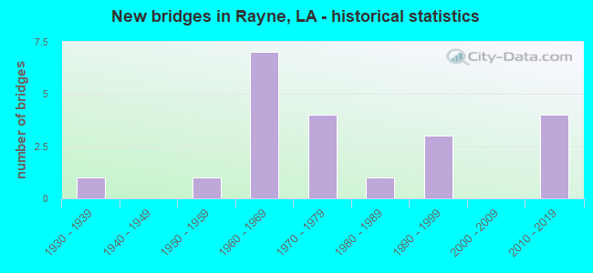
- New bridges - historical statistics
- 11930-1939
- 11950-1959
- 71960-1969
- 41970-1979
- 11980-1989
- 31990-1999
- 42010-2019


- Bridge Condition - Deck
- 17.6%Very good
- 35.3%Good
- 47.1%Satisfactory

- Bridge Condition - Superstructure
- 17.6%Very good
- 35.3%Good
- 47.1%Satisfactory

- Bridge Condition - Substructure
- 5.9%Very good
- 47.1%Good
- 17.6%Satisfactory
- 17.6%Fair
- 11.8%Poor

- Bridge Condition - Channel
- 10.0%Very good
- 65.0%Good
- 25.0%Satisfactory

- Bridge Condition - Culverts
- 25.0%Good
- 75.0%Satisfactory
Find on map >> Show street view
Structure Number: 30100000030476, Location: 1.69 MI NW OF LA 98 (Lat: 30.297011, Lng: -92.243700), Route carried "on" structure: County highway , Year Built: 2016, Status: Posted for load, Structure Length: 1.16m (3.81ft), Average Daily Traffic: 48 (year 2021), Average Future Daily Traffic: 53 (year 2041), Design Load: H 10, Features Intersected: WIKOFF BAYOU, Facility Carried by Structure: CHARLIE ARCENEAUX
Minimum Vertical Clearance: 30+ m (98+ ft), Kilometerpoint: 2.720, Lanes on structure: 2, Owner: County Highway Agency, Approaching Roadway Width: 4.9m (16.1ft), Skew: 30 degrees, Material/Design: Wood or Timber, Design/Construction: Stringer/Multi-beam, Number Of Spans In Main Unit: 2, Length of Maximum Span: 5.8m (19.0ft), Curb-To-Curb Width: 7.0m (23.0ft), Out-to-Out Width: 7.3m (24.0ft)
Condition: Deck: Good, Superstructure: Good, Substructure: Good, Channel: Good, Operating Rating: 31.7 metric tons, Method Used To Determine Operating Rating: Allowable Stress (AS), Inventory Rating: 23.6 metric tons, Method Used To Determine Inventory Rating: Allowable Stress (AS), Structural Evaluation: Equal to present minimum criteria, Deck Geometry: Somewhat better than minimum adequacy, Waterway Adequacy: Better than present minimum criteria, Approach Roadway Alignment: Equal to present desirable criteria, Designated Inspection Frequency: Every 24 months, Inspection Date: July 2020, Deck Structure Type: Wood or Timber, Wearing Surface/Protective System: Wearing Surface: Wood or Timber
Find on map >> Show street view
Structure Number: 30100000200496, Location: 1.2 MILES SOUTH OF LA 98 (Lat: 30.266961, Lng: -92.227600), Route carried "on" structure: County highway , Year Built: 2010, Status: Open, Structure Length: 2.44m (8.01ft), Average Daily Traffic: 528 (year 2020), Truck Traffic: 5%, Average Future Daily Traffic: 581 (year 2040), Design Load: HS 20, Features Intersected: Meche Bayou, Facility Carried by Structure: Meche Rd.
Minimum Vertical Clearance: 30+ m (98+ ft), Kilometerpoint: 0.000, Lanes on structure: 2, Owner: County Highway Agency, Approaching Roadway Width: 7.3m (24.0ft), Skew: 30 degrees, Material/Design: Concrete, Design/Construction: Slab, Number Of Spans In Main Unit: 4, Length of Maximum Span: 6.1m (20.0ft), Curb-To-Curb Width: 7.1m (23.3ft), Out-to-Out Width: 8.1m (26.6ft)
Condition: Deck: Very good, Superstructure: Very good, Substructure: Good, Channel: Good, Operating Rating: 51.5 metric tons, Method Used To Determine Operating Rating: Load and Resistance Factor Rating (LRFR) rating reported by rating factor(RF) method using HL-93 loadings, Inventory Rating: 39.9 metric tons, Method Used To Determine Inventory Rating: Load and Resistance Factor Rating (LRFR) rating reported by rating factor(RF) method using HL-93 loadings, Structural Evaluation: Better than present minimum criteria, Deck Geometry: Meets minimum limits, Waterway Adequacy: Equal to present desirable criteria, Approach Roadway Alignment: Equal to present desirable criteria, Designated Inspection Frequency: Every 24 months, Inspection Date: July 2020, Deck Structure Type: Concrete Precast Panels, Wearing Surface/Protective System: Deck Protection: Epoxy Coated Reinforcing
Find on map >> Show street view
Structure Number: 30100000200539, Location: 1.54 MI EAST OF LA 35 (Lat: 30.298681, Lng: -92.245300), Route carried "on" structure: County highway , Year Built: 2011, Status: Posted for load, Structure Length: 3.26m (10.70ft), Average Daily Traffic: 48 (year 2021), Average Future Daily Traffic: 53 (year 2041), Design Load: H 10, Features Intersected: Wikoff Bayou, Facility Carried by Structure: Charlie Arceneaux
Minimum Vertical Clearance: 30+ m (98+ ft), Kilometerpoint: 0.000, Lanes on structure: 2, Owner: County Highway Agency, Approaching Roadway Width: 7.3m (24.0ft), Material/Design: Wood or Timber, Design/Construction: Stringer/Multi-beam, Number Of Spans In Main Unit: 6, Length of Maximum Span: 5.8m (19.0ft), Curb-To-Curb Width: 6.6m (21.7ft), Out-to-Out Width: 6.9m (22.6ft)
Condition: Deck: Satisfactory, Superstructure: Good, Substructure: Poor, Channel: Good, Operating Rating: 16.3 metric tons, Method Used To Determine Operating Rating: Allowable Stress (AS), Inventory Rating: 11.8 metric tons, Method Used To Determine Inventory Rating: Allowable Stress (AS), Structural Evaluation: Meets minimum limits, Deck Geometry: Somewhat better than minimum adequacy, Waterway Adequacy: Better than present minimum criteria, Approach Roadway Alignment: High priority of corrective action, Bridge Posting: Required (Relationship of Operating Rating to Maximum Legal Load: 20.0 - 29.9% below), Designated Inspection Frequency: Every 24 months, Other Special Inspection Frequency: Every 12 months, Inspection Date: July 2020, Other Special Inspection Date: July 2021, Deck Structure Type: Wood or Timber, Wearing Surface/Protective System: Wearing Surface: Wood or Timber
Find on map >> Show street view
Structure Number: 30100031010411, Location: 2.5 MI EAST OF LA 35 (Lat: 30.235061, Lng: -92.226400), Route carried "on" structure: US 90, Year Built: 1932, Status: Open, Structure Length: 0.70m (2.30ft), Average Daily Traffic: 5,932 (year 2020), Truck Traffic: 13%, Average Future Daily Traffic: 6,525 (year 2040), Design Load: H 15, Features Intersected: CREEK
Minimum Vertical Clearance: 30+ m (98+ ft), Kilometerpoint: 16.723, Lanes on structure: 2, Base Highway Network: Yes (Inventory Route: 3-10-1, Subroute: 10), Owner: State Highway Agency, Approaching Roadway Width: 12.2m (40.0ft), Material/Design: Concrete, Design/Construction: Culvert, Number Of Spans In Main Unit: 4, Length of Maximum Span: 1.5m (4.9ft), Curb-To-Curb Width: 10.1m (33.1ft), Out-to-Out Width: 11.3m (37.1ft)
Condition: Channel: Good, Culverts: Good, Operating Rating: 25.9 metric tons, Method Used To Determine Operating Rating: Load and Resistance Factor Rating (LRFR) rating reported by rating factor(RF) method using HL-93 loadings, Inventory Rating: 19.8 metric tons, Method Used To Determine Inventory Rating: Load and Resistance Factor Rating (LRFR) rating reported by rating factor(RF) method using HL-93 loadings, Structural Evaluation: Somewhat better than minimum adequacy, Deck Geometry: Meets minimum limits, Waterway Adequacy: Equal to present desirable criteria, Approach Roadway Alignment: Equal to present minimum criteria, Designated Inspection Frequency: Every 24 months, Inspection Date: August 2021, Deck Structure Type: Concrete Cast-file-Place
Find on map >> Show street view
Structure Number: 30102070701441, Location: .6 MI NORTH OF LA 98 (Lat: 30.255281, Lng: -92.269200), Route carried "on" structure: State highway 35, Year Built: 1966, Status: Open, Structure Length: 3.05m (10.01ft), Average Daily Traffic: 6,800 (year 2016), Truck Traffic: 9%, Average Future Daily Traffic: 4,200 (year 2036), Design Load: HS 20, Features Intersected: DRAINAGE CANAL BRIDGE
Minimum Vertical Clearance: 30+ m (98+ ft), Kilometerpoint: 2.274, Lanes on structure: 2, Owner: State Highway Agency, Approaching Roadway Width: 13.4m (44.0ft), Material/Design: Concrete, Design/Construction: Slab, Number Of Spans In Main Unit: 5, Length of Maximum Span: 6.1m (20.0ft), Curb-To-Curb Width: 8.6m (28.2ft), Out-to-Out Width: 10.2m (33.5ft)
Condition: Deck: Satisfactory, Superstructure: Satisfactory, Substructure: Good, Channel: Good, Operating Rating: 71.7 metric tons, Method Used To Determine Operating Rating: Load Factor (LF), Inventory Rating: 42.6 metric tons, Method Used To Determine Inventory Rating: Load Factor (LF), Structural Evaluation: Equal to present minimum criteria, Deck Geometry: High priority of replacement, Waterway Adequacy: Better than present minimum criteria, Approach Roadway Alignment: Equal to present minimum criteria, Length Of Structure Improvement: 3.90m (12.80ft), Designated Inspection Frequency: Every 24 months, Inspection Date: Febuary 2021, Bridge Improvement Cost: $332,000, Total Project Cost: $498,000 ( Estimate for 2016), Deck Structure Type: Concrete Cast-file-Place
Find on map >> Show street view
Structure Number: 30102070703701, Location: 2.3 MI NORTH OF LA 98 (Lat: 30.284689, Lng: -92.262700), Route carried "on" structure: State highway 35, Year Built: 1965, Status: Open, Structure Length: 6.10m (20.01ft), Average Daily Traffic: 5,000 (year 2016), Truck Traffic: 13%, Average Future Daily Traffic: 2,760 (year 2036), Design Load: HS 20, Features Intersected: BAYOU WIKOFF
Minimum Vertical Clearance: 30+ m (98+ ft), Kilometerpoint: 5.889, Lanes on structure: 2, Base Highway Network: Yes (Inventory Route: 207-07-1, Subroute: 10), Owner: State Highway Agency, Approaching Roadway Width: 13.4m (44.0ft), Material/Design: Concrete, Design/Construction: Slab, Number Of Spans In Main Unit: 10, Length of Maximum Span: 6.1m (20.0ft), Curb-To-Curb Width: 8.6m (28.2ft), Out-to-Out Width: 10.2m (33.5ft)
Condition: Deck: Satisfactory, Superstructure: Satisfactory, Substructure: Satisfactory, Channel: Satisfactory, Operating Rating: 38.1 metric tons, Method Used To Determine Operating Rating: Load Factor (LF), Inventory Rating: 22.7 metric tons, Method Used To Determine Inventory Rating: Load Factor (LF), Structural Evaluation: Equal to present minimum criteria, Deck Geometry: Meets minimum limits, Waterway Adequacy: Better than present minimum criteria, Approach Roadway Alignment: Better than present minimum criteria, Designated Inspection Frequency: Every 24 months, Inspection Date: Febuary 2021, Deck Structure Type: Concrete Cast-file-Place
Find on map >> Show street view
Structure Number: 30102100404881, Location: 1.1 MI EAST OF LA 367 (Lat: 30.259919, Lng: -92.279100), Route carried "on" structure: State highway 98, Year Built: 1954, Status: Open, Structure Length: 4.27m (14.01ft), Average Daily Traffic: 3,100 (year 2016), Truck Traffic: 13%, Average Future Daily Traffic: 3,410 (year 2036), Design Load: H 15, Features Intersected: B WYCOFF
Minimum Vertical Clearance: 30+ m (98+ ft), Kilometerpoint: 7.804, Lanes on structure: 2, Owner: State Highway Agency, Approaching Roadway Width: 11.0m (36.1ft), Material/Design: Concrete, Design/Construction: Slab, Number Of Spans In Main Unit: 7, Length of Maximum Span: 6.1m (20.0ft), Curb-To-Curb Width: 7.3m (24.0ft), Out-to-Out Width: 8.9m (29.2ft)
Condition: Deck: Satisfactory, Superstructure: Satisfactory, Substructure: Satisfactory, Channel: Good, Operating Rating: 35.4 metric tons, Method Used To Determine Operating Rating: Load Factor (LF), Inventory Rating: 20.9 metric tons, Method Used To Determine Inventory Rating: Load Factor (LF), Structural Evaluation: Somewhat better than minimum adequacy, Deck Geometry: High priority of replacement, Waterway Adequacy: Equal to present minimum criteria, Approach Roadway Alignment: Equal to present desirable criteria, Length Of Structure Improvement: 5.18m (16.99ft), Designated Inspection Frequency: Every 24 months, Inspection Date: Febuary 2021, Bridge Improvement Cost: $442,000, Total Project Cost: $663,000 ( Estimate for 2016), Deck Structure Type: Concrete Cast-file-Place
Find on map >> Show street view
Structure Number: 30102100405341, Location: 1.6 MI EAST OF LA 367 (Lat: 30.255619, Lng: -92.274200), Route carried "on" structure: State highway 98, Year Built: 1973, Status: Posted for load, Structure Length: 2.90m (9.51ft), Average Daily Traffic: 3,100 (year 2016), Truck Traffic: 13%, Average Future Daily Traffic: 2,160 (year 2036), Design Load: HS 20, Features Intersected: CREEK
Minimum Vertical Clearance: 30+ m (98+ ft), Kilometerpoint: 8.530, Lanes on structure: 2, Owner: State Highway Agency, Approaching Roadway Width: 6.4m (21.0ft), Material/Design: Concrete, Design/Construction: Slab, Number Of Spans In Main Unit: 5, Length of Maximum Span: 5.8m (19.0ft), Curb-To-Curb Width: 12.3m (40.4ft), Out-to-Out Width: 13.2m (43.3ft)
Condition: Deck: Satisfactory, Superstructure: Satisfactory, Substructure: Fair, Channel: Good, Operating Rating: 22.7 metric tons, Method Used To Determine Operating Rating: Load and Resistance Factor Rating (LRFR) rating reported by rating factor(RF) method using HL-93 loadings, Inventory Rating: 17.5 metric tons, Method Used To Determine Inventory Rating: Load and Resistance Factor Rating (LRFR) rating reported by rating factor(RF) method using HL-93 loadings, Structural Evaluation: Meets minimum limits, Deck Geometry: Equal to present minimum criteria, Waterway Adequacy: Better than present minimum criteria, Approach Roadway Alignment: Equal to present desirable criteria, Bridge Posting: Required (Relationship of Operating Rating to Maximum Legal Load: 20.0 - 29.9% below), Length Of Structure Improvement: 3.72m (12.20ft), Designated Inspection Frequency: Every 24 months, Inspection Date: December 2021, Bridge Improvement Cost: $319,000, Total Project Cost: $478,000 ( Estimate for 2016), Deck Structure Type: Concrete Precast Panels, Wearing Surface/Protective System: Wearing Surface: Bituminous
Find on map >> Show street view
Structure Number: 30103850102141, Location: 1.3 MI. North of LA 1119 (Lat: 30.159700, Lng: -92.583000), Route carried "on" structure: State highway 92, Year Built: 1962, Status: Open, Structure Length: 3.05m (10.01ft), Average Daily Traffic: 360 (year 2016), Truck Traffic: 12%, Average Future Daily Traffic: 396 (year 2036), Design Load: HS 20, Features Intersected: CREEK
Minimum Vertical Clearance: 30+ m (98+ ft), Kilometerpoint: 3.318, Lanes on structure: 2, Owner: State Highway Agency, Approaching Roadway Width: 11.0m (36.1ft), Skew: 20 degrees, Material/Design: Concrete, Design/Construction: Slab, Number Of Spans In Main Unit: 5, Length of Maximum Span: 6.1m (20.0ft), Curb-To-Curb Width: 7.3m (24.0ft), Out-to-Out Width: 9.0m (29.5ft)
Condition: Deck: Satisfactory, Superstructure: Satisfactory, Substructure: Satisfactory, Channel: Satisfactory, Operating Rating: 39.0 metric tons, Method Used To Determine Operating Rating: Load Factor (LF), Inventory Rating: 23.6 metric tons, Method Used To Determine Inventory Rating: Load Factor (LF), Structural Evaluation: Equal to present minimum criteria, Deck Geometry: Somewhat better than minimum adequacy, Waterway Adequacy: Equal to present desirable criteria, Approach Roadway Alignment: Equal to present desirable criteria, Designated Inspection Frequency: Every 24 months, Inspection Date: Febuary 2021, Deck Structure Type: Concrete Cast-file-Place
Find on map >> Show street view
Structure Number: 30103890102081, Location: 3.27 M. S OF LA 1097 (Lat: 30.251569, Lng: -92.244300), Route carried "on" structure: State highway 98, Year Built: 1965, Status: Open, Structure Length: 6.71m (22.01ft), Average Daily Traffic: 8,424 (year 2020), Truck Traffic: 12%, Average Future Daily Traffic: 9,266 (year 2040), Design Load: HS 20, Features Intersected: I-10
Minimum Vertical Clearance: 30+ m (98+ ft), Kilometerpoint: 3.396, Lanes on structure: 2, Lanes under structure: 4, Owner: State Highway Agency, Approaching Roadway Width: 13.7m (44.9ft), Skew: 31 degrees, Material/Design: Prestressed concrete, Design/Construction: Stringer/Multi-beam, Number Of Spans In Main Unit: 4, Length of Maximum Span: 22.9m (75.1ft), Curb-To-Curb Width: 7.3m (24.0ft), Out-to-Out Width: 9.0m (29.5ft)
Condition: Deck: Good, Superstructure: Good, Substructure: Good, Operating Rating: 75.3 metric tons, Method Used To Determine Operating Rating: Load Factor (LF), Inventory Rating: 29.9 metric tons, Method Used To Determine Inventory Rating: Load Factor (LF), Structural Evaluation: Better than present minimum criteria, Deck Geometry: High priority of replacement, Underclear: Meets minimum limits, Approach Roadway Alignment: Equal to present desirable criteria, Length Of Structure Improvement: 7.62m (25.00ft), Designated Inspection Frequency: Every 24 months, Inspection Date: June 2021, Bridge Improvement Cost: $650,000, Total Project Cost: $975,000 ( Estimate for 2016), Deck Structure Type: Concrete Cast-file-Place, Wearing Surface/Protective System: Wearing Surface: Monolithic Concrete
Find on map >> Show street view
Structure Number: 30103890102731, Location: 0.65 MI NORTH OF I-10 (Lat: 30.260950, Lng: -92.246900), Route carried "on" structure: State highway 98, Year Built: 1996, Status: Open, Structure Length: 3.05m (10.01ft), Average Daily Traffic: 6,800 (year 2016), Truck Traffic: 12%, Average Future Daily Traffic: 4,200 (year 2036), Design Load: HS 20, Features Intersected: DRAINAGE
Minimum Vertical Clearance: 30+ m (98+ ft), Kilometerpoint: 4.514, Lanes on structure: 2, Owner: State Highway Agency, Approaching Roadway Width: 7.3m (24.0ft), Skew: 9 degrees, Material/Design: Concrete, Design/Construction: Slab, Number Of Spans In Main Unit: 5, Length of Maximum Span: 6.1m (20.0ft), Curb-To-Curb Width: 13.4m (44.0ft), Out-to-Out Width: 14.3m (46.9ft)
Condition: Deck: Good, Superstructure: Good, Substructure: Good, Channel: Good, Operating Rating: 73.5 metric tons, Method Used To Determine Operating Rating: Load Factor (LF), Inventory Rating: 43.5 metric tons, Method Used To Determine Inventory Rating: Load Factor (LF), Structural Evaluation: Better than present minimum criteria, Deck Geometry: Equal to present minimum criteria, Waterway Adequacy: Better than present minimum criteria, Approach Roadway Alignment: Equal to present desirable criteria, Designated Inspection Frequency: Every 24 months, Inspection Date: May 2020, Deck Structure Type: Concrete Cast-file-Place
Find on map >> Show street view
Structure Number: 30103950400901, Location: 3.19 MI N of LA 92 (Lat: 30.168989, Lng: -92.268500), Route carried "on" structure: State highway 35, Year Built: 1976, Status: Open, Structure Length: 1.01m (3.31ft), Average Daily Traffic: 1,620 (year 2016), Truck Traffic: 13%, Average Future Daily Traffic: 1,782 (year 2036), Design Load: HS 20, Features Intersected: CREEK
Minimum Vertical Clearance: 30+ m (98+ ft), Kilometerpoint: 1.447, Lanes on structure: 2, Owner: State Highway Agency, Approaching Roadway Width: 7.0m (23.0ft), Skew: 4 degrees, Material/Design: Concrete, Design/Construction: Culvert, Number Of Spans In Main Unit: 3, Length of Maximum Span: 2.1m (6.9ft), Out-to-Out Width: 16.9m (55.4ft)
Condition: Channel: Good, Culverts: Satisfactory, Operating Rating: 42.1 metric tons, Method Used To Determine Operating Rating: Load and Resistance Factor Rating (LRFR) rating reported by rating factor(RF) method using HL-93 loadings, Inventory Rating: 32.4 metric tons, Method Used To Determine Inventory Rating: Load and Resistance Factor Rating (LRFR) rating reported by rating factor(RF) method using HL-93 loadings, Structural Evaluation: Equal to present minimum criteria, Waterway Adequacy: Better than present minimum criteria, Approach Roadway Alignment: Equal to present desirable criteria, Designated Inspection Frequency: Every 24 months, Inspection Date: December 2021, Deck Structure Type: Concrete Cast-file-Place
Find on map >> Show street view
Structure Number: 30104500400001, Location: .4 MI EAST OF LA 97 (Lat: 30.240731, Lng: -92.624531), Route carried "on" structure: Interstate 10, Year Built: 1961, Year Reconstructed: 1974, Status: Open, Structure Length: 48.37m (158.69ft), Average Daily Traffic: 24,900 (year 2016), Truck Traffic: 22%, Average Future Daily Traffic: 16,560 (year 2036), Design Load: HS 20, Features Intersected: BAYOU NAZPIQUE
Minimum Vertical Clearance: 30+ m (98+ ft), Kilometerpoint: 0.005, Lanes on structure: 2, Base Highway Network: Yes (Inventory Route: 450-04-1, Subroute: 10), Owner: State Highway Agency, Approaching Roadway Width: 20.1m (65.9ft), Skew: 10 degrees, Navigation Control: Yes ( Vertical Clearance: 8.8m (28.9ft), Horizontal Clearance: 13.7m (44.9ft)), Material/Design: Steel, Design/Construction: Stringer/Multi-beam, Number Of Spans In Main Unit: 29, Length of Maximum Span: 38.1m (125.0ft), Curb-To-Curb Width: 11.3m (37.1ft), Out-to-Out Width: 12.4m (40.7ft)
Condition: Deck: Satisfactory, Superstructure: Satisfactory, Substructure: Good, Channel: Satisfactory, Operating Rating: 70.7 metric tons, Method Used To Determine Operating Rating: Load Factor (LF), Inventory Rating: 42.6 metric tons, Method Used To Determine Inventory Rating: Load Factor (LF), Structural Evaluation: Equal to present minimum criteria, Deck Geometry: Somewhat better than minimum adequacy, Waterway Adequacy: Equal to present desirable criteria, Approach Roadway Alignment: Equal to present desirable criteria, Designated Inspection Frequency: Every 24 months, Underwater Inspection Frequency: Every 60 months, Inspection Date: March 2021, Underwater Inspection Date: October 2018, Deck Structure Type: Concrete Cast-file-Place
Find on map >> Show street view
Structure Number: 30104500422051, Location: .6 MI EAST OF LA 35 (Lat: 30.252261, Lng: -92.260600), Route carried "on" structure: Interstate 10, Year Built: 1966, Status: Open, Structure Length: 0.94m (3.08ft), Average Daily Traffic: 56,100 (year 2016), Truck Traffic: 28%, Average Future Daily Traffic: 31,680 (year 2036), Design Load: HS 20, Features Intersected: DRAIN
Minimum Vertical Clearance: 30+ m (98+ ft), Kilometerpoint: 35.504, Lanes on structure: 4, Base Highway Network: Yes (Inventory Route: 450-04-1, Subroute: 10), Owner: State Highway Agency, Approaching Roadway Width: 13.1m (43.0ft), Skew: 13 degrees, Material/Design: Concrete, Design/Construction: Culvert, Number Of Spans In Main Unit: 3, Length of Maximum Span: 2.4m (7.9ft), Curb-To-Curb Width: 24.4m (80.1ft), Out-to-Out Width: 52.9m (173.6ft)
Condition: Channel: Very good, Culverts: Satisfactory, Operating Rating: 42.1 metric tons, Method Used To Determine Operating Rating: Load and Resistance Factor Rating (LRFR) rating reported by rating factor(RF) method using HL-93 loadings, Inventory Rating: 32.4 metric tons, Method Used To Determine Inventory Rating: Load and Resistance Factor Rating (LRFR) rating reported by rating factor(RF) method using HL-93 loadings, Structural Evaluation: Equal to present minimum criteria, Deck Geometry: Superior to present desirable criteria, Waterway Adequacy: Equal to present desirable criteria, Approach Roadway Alignment: Equal to present desirable criteria, Designated Inspection Frequency: Every 24 months, Inspection Date: June 2021, Deck Structure Type: Concrete Cast-file-Place
Find on map >> Show street view
Structure Number: 30130129921561, Location: 0.47 Mi. E. of La 35 (Lat: 30.215161, Lng: -92.261181), Route carried "on" structure: County highway , Year Built: 1993, Status: Open, Structure Length: 2.32m (7.61ft), Average Daily Traffic: 3,600 (year 2020), Average Future Daily Traffic: 3,960 (year 2040), Design Load: HS 20, Features Intersected: COULEE, Facility Carried by Structure: Standard Mill Rd
Minimum Vertical Clearance: 30+ m (98+ ft), Kilometerpoint: 0.000, Lanes on structure: 2, Owner: County Highway Agency, Approaching Roadway Width: 8.2m (26.9ft), Material/Design: Concrete, Design/Construction: Slab, Number Of Spans In Main Unit: 4, Length of Maximum Span: 5.8m (19.0ft), Curb-To-Curb Width: 8.5m (27.9ft), Out-to-Out Width: 9.4m (30.8ft)
Condition: Deck: Good, Superstructure: Good, Substructure: Good, Channel: Good, Operating Rating: 25.3 metric tons, Method Used To Determine Operating Rating: Load and Resistance Factor Rating (LRFR) rating reported by rating factor(RF) method using HL-93 loadings, Inventory Rating: 19.8 metric tons, Method Used To Determine Inventory Rating: Load and Resistance Factor Rating (LRFR) rating reported by rating factor(RF) method using HL-93 loadings, Structural Evaluation: Somewhat better than minimum adequacy, Deck Geometry: Meets minimum limits, Waterway Adequacy: Equal to present minimum criteria, Approach Roadway Alignment: Equal to present desirable criteria, Designated Inspection Frequency: Every 24 months, Inspection Date: July 2020, Deck Structure Type: Concrete Cast-file-Place
Find on map >> Show street view
Structure Number: 30130129921671, Location: 0.5 Mi W. of La 35 (Lat: 30.214961, Lng: -92.277750), Route carried "on" structure: County highway , Year Built: 1986, Status: Open, Structure Length: 0.88m (2.89ft), Average Daily Traffic: 2,400 (year 2020), Average Future Daily Traffic: 2,640 (year 2040), Design Load: HS 20, Features Intersected: COULEE, Facility Carried by Structure: Standard Mill Rd
Minimum Vertical Clearance: 30+ m (98+ ft), Kilometerpoint: 0.000, Lanes on structure: 2, Owner: County Highway Agency, Approaching Roadway Width: 7.9m (25.9ft), Material/Design: Steel, Design/Construction: Culvert, Number Of Spans In Main Unit: 3, Length of Maximum Span: 2.4m (7.9ft)
Condition: Channel: Good, Culverts: Satisfactory, Operating Rating: 97.2 metric tons, Method Used To Determine Operating Rating: Load and Resistance Factor Rating (LRFR) rating reported by rating factor(RF) method using HL-93 loadings, Inventory Rating: 74.5 metric tons, Method Used To Determine Inventory Rating: Load and Resistance Factor Rating (LRFR) rating reported by rating factor(RF) method using HL-93 loadings, Structural Evaluation: Equal to present minimum criteria, Waterway Adequacy: Equal to present minimum criteria, Approach Roadway Alignment: Equal to present desirable criteria, Length Of Structure Improvement: 1.49m (4.89ft), Designated Inspection Frequency: Every 24 months, Inspection Date: July 2020, Bridge Improvement Cost: $89,000, Total Project Cost: $133,000 ( Estimate for 2016)
Find on map >> Show street view
Structure Number: 30130152921551, Location: 0.6 Mi. S. of La 13 (Lat: 30.252850, Lng: -92.260850), Route carried "on" structure: County highway , Year Built: 1970, Status: Posted for load, Structure Length: 0.98m (3.22ft), Average Daily Traffic: 336 (year 2020), Average Future Daily Traffic: 370 (year 2040), Design Load: H 15, Features Intersected: Duralde Coulee, Facility Carried by Structure: Nation Rd.
Minimum Vertical Clearance: 30+ m (98+ ft), Kilometerpoint: 0.000, Lanes on structure: 2, Owner: County Highway Agency, Approaching Roadway Width: 7.3m (24.0ft), Skew: 3 degrees, Material/Design: Wood or Timber, Design/Construction: Stringer/Multi-beam, Number Of Spans In Main Unit: 2, Length of Maximum Span: 4.9m (16.1ft), Curb-To-Curb Width: 5.7m (18.7ft), Out-to-Out Width: 5.9m (19.4ft)
Condition: Deck: Good, Superstructure: Satisfactory, Substructure: Poor, Channel: Good, Operating Rating: 22.7 metric tons, Method Used To Determine Operating Rating: Allowable Stress (AS), Inventory Rating: 15.9 metric tons, Method Used To Determine Inventory Rating: Allowable Stress (AS), Structural Evaluation: Meets minimum limits, Deck Geometry: High priority of corrective action, Waterway Adequacy: Equal to present minimum criteria, Approach Roadway Alignment: Equal to present minimum criteria, Bridge Posting: Required (Relationship of Operating Rating to Maximum Legal Load: 0.1 - 9.9% below), Designated Inspection Frequency: Every 24 months, Other Special Inspection Frequency: Every 12 months, Inspection Date: July 2020, Other Special Inspection Date: July 2021, Deck Structure Type: Wood or Timber, Wearing Surface/Protective System: Wearing Surface: Bituminous
Find on map >> Show street view
Structure Number: 30130159921931, Location: 1.6 Mi S. of La 98 (Lat: 30.264150, Lng: -92.322619), Route carried "on" structure: County highway , Year Built: 1965, Status: Posted for load, Structure Length: 3.44m (11.29ft), Average Daily Traffic: 28 (year 2020), Average Future Daily Traffic: 31 (year 2040), Design Load: H 10, Features Intersected: WICKOFF BAYOU, Facility Carried by Structure: Ohlenforst Rd.
Minimum Vertical Clearance: 30+ m (98+ ft), Kilometerpoint: 0.000, Lanes on structure: 2, Owner: County Highway Agency, Approaching Roadway Width: 5.5m (18.0ft), Material/Design: Wood or Timber, Design/Construction: Stringer/Multi-beam, Number Of Spans In Main Unit: 6, Length of Maximum Span: 6.1m (20.0ft), Curb-To-Curb Width: 6.1m (20.0ft), Out-to-Out Width: 6.1m (20.0ft)
Condition: Deck: Good, Superstructure: Good, Substructure: Fair, Channel: Satisfactory, Operating Rating: 17.0 metric tons, Method Used To Determine Operating Rating: Allowable Stress (AS), Inventory Rating: 12.4 metric tons, Method Used To Determine Inventory Rating: Allowable Stress (AS), Structural Evaluation: Meets minimum limits, Deck Geometry: Somewhat better than minimum adequacy, Waterway Adequacy: Better than present minimum criteria, Approach Roadway Alignment: High priority of corrective action, Bridge Posting: Required (Relationship of Operating Rating to Maximum Legal Load: 20.0 - 29.9% below), Length Of Structure Improvement: 4.33m (14.21ft), Designated Inspection Frequency: Every 24 months, Inspection Date: July 2020, Bridge Improvement Cost: $258,000, Total Project Cost: $387,000 ( Estimate for 2016), Deck Structure Type: Wood or Timber, Wearing Surface/Protective System: Wearing Surface: Bituminous
Find on map >> Show street view
Structure Number: 30130163921441, Location: 0.2 Mi. E. of La 98 (Lat: 30.271461, Lng: -92.240089), Route carried "on" structure: County highway , Year Built: 1993, Status: Open, Structure Length: 1.16m (3.81ft), Average Daily Traffic: 48 (year 2020), Average Future Daily Traffic: 53 (year 2040), Design Load: HS 20, Features Intersected: COULEE, Facility Carried by Structure: Welch Rd.
Minimum Vertical Clearance: 30+ m (98+ ft), Kilometerpoint: 0.000, Lanes on structure: 2, Owner: County Highway Agency, Approaching Roadway Width: 9.1m (29.9ft), Skew: 7 degrees, Material/Design: Concrete, Design/Construction: Slab, Number Of Spans In Main Unit: 2, Length of Maximum Span: 5.8m (19.0ft), Curb-To-Curb Width: 7.3m (24.0ft), Out-to-Out Width: 8.2m (26.9ft)
Condition: Deck: Very good, Superstructure: Very good, Substructure: Good, Channel: Very good, Operating Rating: 47.3 metric tons, Method Used To Determine Operating Rating: Load and Resistance Factor Rating (LRFR) rating reported by rating factor(RF) method using HL-93 loadings, Inventory Rating: 36.3 metric tons, Method Used To Determine Inventory Rating: Load and Resistance Factor Rating (LRFR) rating reported by rating factor(RF) method using HL-93 loadings, Structural Evaluation: Better than present minimum criteria, Deck Geometry: Equal to present minimum criteria, Waterway Adequacy: Equal to present desirable criteria, Approach Roadway Alignment: Equal to present desirable criteria, Designated Inspection Frequency: Every 24 months, Inspection Date: July 2020, Deck Structure Type: Concrete Cast-file-Place
Find on map >> Show street view
Structure Number: 32800000030462, Location: 1.14 Mi E of LA 35 (Lat: 30.198639, Lng: -92.249950), Route carried "on" structure: County highway , Year Built: 2015, Status: Open, Structure Length: 3.20m (10.50ft), Average Daily Traffic: 66 (year 2020), Average Future Daily Traffic: 162 (year 2040), Design Load: HL 93, Features Intersected: DUEUE DE TORTUE BAYOU, Facility Carried by Structure: W. Congress St.
Minimum Vertical Clearance: 30+ m (98+ ft), Kilometerpoint: 0.000, Lanes on structure: 2, Owner: County Highway Agency, Approaching Roadway Width: 5.6m (18.4ft), Material/Design: Concrete, Design/Construction: Slab, Number Of Spans In Main Unit: 5, Length of Maximum Span: 7.6m (24.9ft), Curb-To-Curb Width: 8.4m (27.6ft), Out-to-Out Width: 9.4m (30.8ft)
Condition: Deck: Very good, Superstructure: Very good, Substructure: Very good, Channel: Good, Operating Rating: 45.0 metric tons, Method Used To Determine Operating Rating: Load and Resistance Factor Rating (LRFR) rating reported by rating factor(RF) method using HL-93 loadings, Inventory Rating: 34.7 metric tons, Method Used To Determine Inventory Rating: Load and Resistance Factor Rating (LRFR) rating reported by rating factor(RF) method using HL-93 loadings, Structural Evaluation: Equal to present desirable criteria, Deck Geometry: Equal to present minimum criteria, Waterway Adequacy: Equal to present desirable criteria, Approach Roadway Alignment: High priority of corrective action, Designated Inspection Frequency: Every 24 months, Inspection Date: October 2021, Deck Structure Type: Concrete Cast-file-Place, Wearing Surface/Protective System: Wearing Surface: Monolithic Concrete
Find on map >> Show street view
Structure Number: 32808283000001, Location: 2.48 MI WEST OF LA 719 (Lat: 30.214911, Lng: -92.241911), Route carried "on" structure: State highway 720, Year Built: 1972, Status: Open, Structure Length: 2.90m (9.51ft), Average Daily Traffic: 940 (year 2016), Truck Traffic: 13%, Average Future Daily Traffic: 1,171 (year 2036), Design Load: HS 20, Features Intersected: B QUEUE DE TORTUE
Minimum Vertical Clearance: 30+ m (98+ ft), Kilometerpoint: 0.000, Lanes on structure: 2, Owner: State Highway Agency, Approaching Roadway Width: 9.8m (32.2ft), Material/Design: Concrete, Design/Construction: Slab, Number Of Spans In Main Unit: 3, Length of Maximum Span: 5.8m (19.0ft), Curb-To-Curb Width: 8.6m (28.2ft), Out-to-Out Width: 9.4m (30.8ft)
Condition: Deck: Satisfactory, Superstructure: Satisfactory, Substructure: Fair, Channel: Satisfactory, Operating Rating: 31.8 metric tons, Method Used To Determine Operating Rating: Load and Resistance Factor Rating (LRFR) rating reported by rating factor(RF) method using HL-93 loadings, Inventory Rating: 24.6 metric tons, Method Used To Determine Inventory Rating: Load and Resistance Factor Rating (LRFR) rating reported by rating factor(RF) method using HL-93 loadings, Structural Evaluation: Somewhat better than minimum adequacy, Deck Geometry: Somewhat better than minimum adequacy, Waterway Adequacy: Equal to present desirable criteria, Approach Roadway Alignment: High priority of corrective action, Length Of Structure Improvement: 3.72m (12.20ft), Designated Inspection Frequency: Every 24 months, Inspection Date: November 2020, Bridge Improvement Cost: $317,000, Total Project Cost: $475,000 ( Estimate for 2016), Deck Structure Type: Concrete Precast Panels, Wearing Surface/Protective System: Wearing Surface: Bituminous
Find on map >> Show street view
Structure Number: 30103890102081, Location: 1.50 MI E OF LA 35 (Lat: 30.251761, Lng: -92.244381), Route carried "under" structure: Interstate 10, Structure Length: 0. m, Average Daily Traffic: 52,800 (year 2014), Features Intersected: I-10 EAST BOUND UNDER LA
Minimum Vertical Clearance: 5.00m (16.40ft), Kilometerpoint: 37.065, Lanes on structure: 2, Length of Maximum Span: 0.0m
Find on map >> Show street view
Structure Number: 30103890102081, Location: 3.0 MI. W OF LA 95 (Lat: 30.252000, Lng: -92.244400), Route carried "under" structure: Interstate 10, Structure Length: 0. m, Average Daily Traffic: 52,800 (year 2014), Features Intersected: I-10 WEST BOUND UNDER LA
Minimum Vertical Clearance: 4.97m (16.31ft), Kilometerpoint: 6.590, Lanes on structure: 2, Length of Maximum Span: 0.0m
Find on map >> Show street view
Structure Number: 30103900200281, Location: 2.06 MI E OF LA 98 (Lat: 30.247681, Lng: -92.210311), Route carried "under" structure: Interstate 10, Structure Length: 0. m, Average Daily Traffic: 52,800 (year 2014), Features Intersected: I-10 EAST BOUND UNDER LA
Minimum Vertical Clearance: 5.03m (16.50ft), Kilometerpoint: 40.377, Lanes on structure: 2, Length of Maximum Span: 0.0m
Find on map >> Show street view
Structure Number: 30104500420451, Location: 4.1 MI. E OF LA 1111 (Lat: 30.248050, Lng: -92.296531), Route carried "under" structure: Interstate 10, Structure Length: 0. m, Average Daily Traffic: 40,700 (year 2014), Features Intersected: I-10 EAST BOUND UNDER WE
Minimum Vertical Clearance: 4.97m (16.31ft), Kilometerpoint: 31.970, Lanes on structure: 2, Length of Maximum Span: 0.0m
Find on map >> Show street view
Structure Number: 30104500420451, Location: 4.1 MI EAST OF LA 1111 (Lat: 30.248289, Lng: -92.296650), Route carried "under" structure: Interstate 10, Structure Length: 0. m, Average Daily Traffic: 40,700 (year 2014), Features Intersected: I- 10 WEST BOUND UNDER W
Minimum Vertical Clearance: 4.94m (16.21ft), Kilometerpoint: 11.700, Lanes on structure: 2, Length of Maximum Span: 0.0m
Find on map >> Show street view
Structure Number: 30104500421491, Location: 6.0 MI S OF 1101 (Lat: 30.252261, Lng: -92.269739), Route carried "under" structure: State highway 35, Structure Length: 0. m, Average Daily Traffic: 13,900 (year 2014), Features Intersected: LA 35 SOUTH BOUND UNDER
Minimum Vertical Clearance: 4.57m (14.99ft), Kilometerpoint: 19.171, Lanes on structure: 3, Length of Maximum Span: 0.0m
Find on map >> Show street view
Structure Number: 30104500421491, Location: 0.6 MI N OF LA 98 (Lat: 30.252161, Lng: -92.269539), Route carried "under" structure: State highway 35, Structure Length: 0. m, Average Daily Traffic: 13,900 (year 2014), Features Intersected: LA 35 NORTH BOUND UNDER
Minimum Vertical Clearance: 4.57m (14.99ft), Kilometerpoint: 1.923, Lanes on structure: 3, Length of Maximum Span: 0.0m
Find on map >> Show street view
Structure Number: 30104500421492, Location: 6.01 MI S OF LA 1101 (Lat: 30.252469, Lng: -92.269739), Route carried "under" structure: State highway 35, Structure Length: 0. m, Average Daily Traffic: 13,900 (year 2014), Features Intersected: LA 35 SOUTH BOUND UNDER
Minimum Vertical Clearance: 4.60m (15.09ft), Kilometerpoint: 19.148, Lanes on structure: 3, Length of Maximum Span: 0.0m
Find on map >> Show street view
Structure Number: 30104500421492, Location: 0.65 MI N OF LA 98 (Lat: 30.252400, Lng: -92.269550), Route carried "under" structure: State highway 35, Structure Length: 0. m, Average Daily Traffic: 13,900 (year 2014), Features Intersected: LA 35 NORTH BOUND UNDER
Minimum Vertical Clearance: 4.57m (14.99ft), Kilometerpoint: 1.949, Lanes on structure: 3, Length of Maximum Span: 0.0m