Bridge Statistics for Suamico, Wisconsin (WI)
Condition, Traffic, Stress, Structural Evaluation, Project Costs
- National Bridge Inventory (NBI) Statistics
- 25Number of bridges
- 223ft / 68.1mTotal length
- $272,000Total costs
- 281,861Total average daily traffic
- 33,936Total average daily truck traffic
- National Bridge Inventory (NBI) Registered Bridges for Suamico
- No street view available for this location
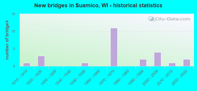
- New bridges - historical statistics
- 11910-1919
- 31920-1929
- 11950-1959
- 111970-1979
- 21990-1999
- 42000-2009
- 12010-2019
- 22020-2022

- Reconstructed bridges - Historical Statistics
- 11960-1969
- 01970-1979
- 21980-1989
- 01990-1999
- 22000-2009
- 42010-2019


- Bridge Condition - Deck
- 11.8%Excellent
- 35.3%Very good
- 29.4%Good
- 11.8%Satisfactory
- 11.8%Fair

- Bridge Condition - Superstructure
- 17.6%Excellent
- 29.4%Very good
- 23.5%Good
- 23.5%Satisfactory
- 5.9%Fair

- Bridge Condition - Substructure
- 11.8%Excellent
- 29.4%Very good
- 23.5%Good
- 23.5%Satisfactory
- 11.8%Fair

- Bridge Condition - Channel
- 27.3%Excellent
- 54.5%Very good
- 18.2%Satisfactory
Find on map >> Show street view
Structure Number: B050036, Location: 0.2M S JCT CTH B (Lat: 44.632750, Lng: -88.049442), Route carried "on" structure: City street , Year Built: 1956, Status: Open, Structure Length: 2.30m (7.55ft), Average Daily Traffic: 1,493 (year 2019), Average Future Daily Traffic: 1,642 (year 2039), Design Load: H 15, Features Intersected: SUAMICO RIVER, Facility Carried by Structure: LRD DEERFIELD RD
Minimum Vertical Clearance: 30+ m (98+ ft), Kilometerpoint: 0.000, Lanes on structure: 2, Owner: City or Municipal Highway Agency, Approaching Roadway Width: 8.5m (27.9ft), Material/Design: Steel, Design/Construction: Stringer/Multi-beam, Number Of Spans In Main Unit: 1, Length of Maximum Span: 22.6m (74.1ft), Curb or Sidewalk Widths: Left: 2.0m (6.6ft), Right: 0.0m, Curb-To-Curb Width: 7.5m (24.6ft), Out-to-Out Width: 10.1m (33.1ft)
Condition: Deck: Fair, Superstructure: Good, Substructure: Fair, Channel: Very good, Operating Rating: 50.6 metric tons, Method Used To Determine Operating Rating: Load Factor (LF), Inventory Rating: 29.2 metric tons, Method Used To Determine Inventory Rating: Load Factor (LF), Structural Evaluation: Somewhat better than minimum adequacy, Deck Geometry: Meets minimum limits, Waterway Adequacy: Equal to present desirable criteria, Approach Roadway Alignment: Equal to present desirable criteria, Designated Inspection Frequency: Every 24 months, Inspection Date: September 2020, Deck Structure Type: Concrete Cast-file-Place, Wearing Surface/Protective System: Wearing Surface: Bituminous
Find on map >> Show street view
Structure Number: B050072, Location: 6.2M S JCT CTH S (Lat: 44.631969, Lng: -88.047878), Route carried "on" structure: US 41, Year Built: 1970, Year Reconstructed: 2000, Status: Open, Structure Length: 5.98m (19.62ft), Average Daily Traffic: 22,500 (year 2021), Truck Traffic: 16%, Average Future Daily Traffic: 35,940 (year 2040), Design Load: HS 20, Features Intersected: LRD RIVERSIDE DR. & SUAM
Minimum Vertical Clearance: 30+ m (98+ ft), Kilometerpoint: 0.000, Lanes on structure: 3, Lanes under structure: 2, Base Highway Network: Yes, Owner: State Highway Agency, Approaching Roadway Width: 12.2m (40.0ft), Skew: 1 degrees, Material/Design: Steel continuous, Design/Construction: Stringer/Multi-beam, Number Of Spans In Main Unit: 2, Length of Maximum Span: 29.3m (96.1ft), Curb-To-Curb Width: 15.8m (51.8ft), Out-to-Out Width: 16.7m (54.8ft)
Condition: Deck: Good, Superstructure: Good, Substructure: Good, Channel: Very good, Operating Rating: 53.9 metric tons, Method Used To Determine Operating Rating: Load Factor (LF), Inventory Rating: 32.4 metric tons, Method Used To Determine Inventory Rating: Load Factor (LF), Structural Evaluation: Better than present minimum criteria, Deck Geometry: Better than present minimum criteria, Underclear: Equal to present minimum criteria, Waterway Adequacy: Equal to present desirable criteria, Approach Roadway Alignment: Equal to present desirable criteria, Designated Inspection Frequency: Every 24 months, Inspection Date: August 2021, Deck Structure Type: Concrete Cast-file-Place, Wearing Surface/Protective System: Wearing Surface: Epoxy Overlay, Deck Protection: Epoxy Coated Reinforcing
Find on map >> Show street view
Structure Number: B050073, Location: 5.6M N JCT USH 141 TO S (Lat: 44.631242, Lng: -88.047694), Route carried "on" structure: US 41, Year Built: 1970, Year Reconstructed: 2000, Status: Open, Structure Length: 5.98m (19.62ft), Average Daily Traffic: 22,500 (year 2021), Truck Traffic: 16%, Average Future Daily Traffic: 35,940 (year 2040), Design Load: HS 20, Features Intersected: LRD RIVERSIDE DR. & SUAM
Minimum Vertical Clearance: 30+ m (98+ ft), Kilometerpoint: 0.000, Lanes on structure: 3, Lanes under structure: 2, Base Highway Network: Yes, Owner: State Highway Agency, Approaching Roadway Width: 12.2m (40.0ft), Skew: 1 degrees, Material/Design: Steel continuous, Design/Construction: Stringer/Multi-beam, Number Of Spans In Main Unit: 2, Length of Maximum Span: 29.3m (96.1ft), Curb-To-Curb Width: 13.4m (44.0ft), Out-to-Out Width: 14.3m (46.9ft)
Condition: Deck: Very good, Superstructure: Good, Substructure: Good, Channel: Very good, Operating Rating: 53.9 metric tons, Method Used To Determine Operating Rating: Load Factor (LF), Inventory Rating: 32.4 metric tons, Method Used To Determine Inventory Rating: Load Factor (LF), Structural Evaluation: Better than present minimum criteria, Deck Geometry: Somewhat better than minimum adequacy, Underclear: Equal to present minimum criteria, Waterway Adequacy: Equal to present desirable criteria, Approach Roadway Alignment: Equal to present desirable criteria, Designated Inspection Frequency: Every 24 months, Inspection Date: August 2021, Deck Structure Type: Concrete Cast-file-Place, Wearing Surface/Protective System: Wearing Surface: Epoxy Overlay, Deck Protection: Epoxy Coated Reinforcing
Find on map >> Show street view
Structure Number: B050076, Location: 6.0M S JCT CTH S (Lat: 44.635364, Lng: -88.046300), Route carried "on" structure: US 41, Year Built: 1970, Year Reconstructed: 2018, Status: Open, Structure Length: 5.28m (17.32ft), Average Daily Traffic: 22,500 (year 2021), Truck Traffic: 16%, Average Future Daily Traffic: 35,940 (year 2040), Design Load: HS 20, Features Intersected: CTH B (SUNSET BEACH RD)
Minimum Vertical Clearance: 30+ m (98+ ft), Kilometerpoint: 0.000, Lanes on structure: 2, Lanes under structure: 2, Base Highway Network: Yes, Owner: State Highway Agency, Approaching Roadway Width: 12.2m (40.0ft), Skew: 2 degrees, Material/Design: Prestressed concrete continuous, Design/Construction: Stringer/Multi-beam, Number Of Spans In Main Unit: 2, Length of Maximum Span: 26.2m (86.0ft), Curb-To-Curb Width: 12.3m (40.4ft), Out-to-Out Width: 13.1m (43.0ft)
Condition: Deck: Good, Superstructure: Satisfactory, Substructure: Good, Operating Rating: 73.0 metric tons, Method Used To Determine Operating Rating: Load Factor (LF), Inventory Rating: 27.5 metric tons, Method Used To Determine Inventory Rating: Load Factor (LF), Structural Evaluation: Equal to present minimum criteria, Deck Geometry: Better than present minimum criteria, Underclear: Equal to present minimum criteria, Approach Roadway Alignment: Equal to present desirable criteria, Designated Inspection Frequency: Every 24 months, Inspection Date: August 2021, Deck Structure Type: Concrete Cast-file-Place, Wearing Surface/Protective System: Wearing Surface: Epoxy Overlay
Find on map >> Show street view
Structure Number: B050077, Location: 5.8M N JCT USH 141 TO S (Lat: 44.634978, Lng: -88.045889), Route carried "on" structure: US 41, Year Built: 1970, Year Reconstructed: 2018, Status: Open, Structure Length: 5.43m (17.81ft), Average Daily Traffic: 22,500 (year 2021), Truck Traffic: 16%, Average Future Daily Traffic: 35,940 (year 2040), Design Load: HS 20, Features Intersected: CTH B SUNSET BEACH RD
Minimum Vertical Clearance: 30+ m (98+ ft), Kilometerpoint: 0.000, Lanes on structure: 2, Lanes under structure: 2, Base Highway Network: Yes, Owner: State Highway Agency, Approaching Roadway Width: 12.2m (40.0ft), Skew: 2 degrees, Material/Design: Prestressed concrete continuous, Design/Construction: Stringer/Multi-beam, Number Of Spans In Main Unit: 2, Length of Maximum Span: 27.0m (88.6ft), Curb-To-Curb Width: 12.3m (40.4ft), Out-to-Out Width: 13.1m (43.0ft)
Condition: Deck: Very good, Superstructure: Satisfactory, Substructure: Good, Operating Rating: 73.0 metric tons, Method Used To Determine Operating Rating: Load Factor (LF), Inventory Rating: 27.5 metric tons, Method Used To Determine Inventory Rating: Load Factor (LF), Structural Evaluation: Equal to present minimum criteria, Deck Geometry: Better than present minimum criteria, Underclear: Better than present minimum criteria, Approach Roadway Alignment: Equal to present desirable criteria, Designated Inspection Frequency: Every 24 months, Inspection Date: August 2021, Deck Structure Type: Concrete Cast-file-Place, Wearing Surface/Protective System: Wearing Surface: Epoxy Overlay
Find on map >> Show street view
Structure Number: B050078, Location: 5.6M S JCT CTH S (Lat: 44.640275, Lng: -88.046897), Route carried "on" structure: US 41, Year Built: 1970, Year Reconstructed: 2018, Status: Open, Structure Length: 6.07m (19.91ft), Average Daily Traffic: 22,500 (year 2021), Truck Traffic: 16%, Average Future Daily Traffic: 35,940 (year 2040), Design Load: HS 20, Features Intersected: CNW RR
Minimum Vertical Clearance: 30+ m (98+ ft), Kilometerpoint: 0.000, Lanes on structure: 2, Base Highway Network: Yes, Owner: State Highway Agency, Approaching Roadway Width: 12.2m (40.0ft), Skew: 5 degrees, Material/Design: Prestressed concrete continuous, Design/Construction: Stringer/Multi-beam, Number Of Spans In Main Unit: 3, Length of Maximum Span: 19.7m (64.6ft), Curb-To-Curb Width: 12.3m (40.4ft), Out-to-Out Width: 13.1m (43.0ft)
Condition: Deck: Very good, Superstructure: Satisfactory, Substructure: Satisfactory, Operating Rating: 63.7 metric tons, Method Used To Determine Operating Rating: Load Factor (LF), Inventory Rating: 30.8 metric tons, Method Used To Determine Inventory Rating: Load Factor (LF), Structural Evaluation: Equal to present minimum criteria, Deck Geometry: Better than present minimum criteria, Underclear: Better than present minimum criteria, Approach Roadway Alignment: Equal to present desirable criteria, Designated Inspection Frequency: Every 24 months, Inspection Date: August 2021, Deck Structure Type: Concrete Cast-file-Place, Wearing Surface/Protective System: Wearing Surface: Epoxy Overlay
Find on map >> Show street view
Structure Number: B050079, Location: 6.2M N JCT USH 141 TO S (Lat: 44.640294, Lng: -88.046347), Route carried "on" structure: US 41, Year Built: 1970, Year Reconstructed: 2018, Status: Open, Structure Length: 6.01m (19.72ft), Average Daily Traffic: 22,500 (year 2021), Truck Traffic: 16%, Average Future Daily Traffic: 35,940 (year 2040), Design Load: HS 20, Features Intersected: CNW RR
Minimum Vertical Clearance: 30+ m (98+ ft), Kilometerpoint: 0.000, Lanes on structure: 3, Base Highway Network: Yes, Owner: State Highway Agency, Approaching Roadway Width: 12.2m (40.0ft), Skew: 4 degrees, Material/Design: Prestressed concrete continuous, Design/Construction: Stringer/Multi-beam, Number Of Spans In Main Unit: 3, Length of Maximum Span: 19.8m (65.0ft), Curb-To-Curb Width: 15.7m (51.5ft), Out-to-Out Width: 16.5m (54.1ft)
Condition: Deck: Very good, Superstructure: Satisfactory, Substructure: Satisfactory, Operating Rating: 63.7 metric tons, Method Used To Determine Operating Rating: Load Factor (LF), Inventory Rating: 30.8 metric tons, Method Used To Determine Inventory Rating: Load Factor (LF), Structural Evaluation: Equal to present minimum criteria, Deck Geometry: Better than present minimum criteria, Underclear: Equal to present desirable criteria, Approach Roadway Alignment: Equal to present desirable criteria, Designated Inspection Frequency: Every 24 months, Inspection Date: August 2021, Deck Structure Type: Concrete Cast-file-Place, Wearing Surface/Protective System: Wearing Surface: Epoxy Overlay
Find on map >> Show street view
Structure Number: B050261, Location: 1.5M S JCT CTH B (Lat: 44.625506, Lng: -88.079931), Route carried "on" structure: City street , Year Built: 1928, Year Reconstructed: 1980, Status: Open, Structure Length: 2.10m (6.89ft), Average Daily Traffic: 88 (year 2019), Average Future Daily Traffic: 96 (year 2039), Design Load: H 20, Features Intersected: SUAMICO RIVER, Facility Carried by Structure: LRD BRIDGE RD
Minimum Vertical Clearance: 30+ m (98+ ft), Kilometerpoint: 0.000, Lanes on structure: 2, Owner: City or Municipal Highway Agency, Approaching Roadway Width: 7.3m (24.0ft), Material/Design: Prestressed concrete, Design/Construction: Slab, Number Of Spans In Main Unit: 2, Length of Maximum Span: 10.1m (33.1ft), Curb-To-Curb Width: 7.3m (24.0ft), Out-to-Out Width: 7.5m (24.6ft)
Condition: Deck: Satisfactory, Superstructure: Very good, Substructure: Fair, Channel: Satisfactory, Operating Rating: 62.1 metric tons, Method Used To Determine Operating Rating: Load Factor (LF), Inventory Rating: 35.6 metric tons, Method Used To Determine Inventory Rating: Load Factor (LF), Structural Evaluation: Somewhat better than minimum adequacy, Deck Geometry: Equal to present minimum criteria, Waterway Adequacy: Equal to present desirable criteria, Approach Roadway Alignment: Equal to present desirable criteria, Designated Inspection Frequency: Every 24 months, Inspection Date: September 2020, Deck Structure Type: Concrete Cast-file-Place, Wearing Surface/Protective System: Wearing Surface: Bituminous
Find on map >> Show street view
Structure Number: B050292, Location: 0.2M S JCT CTH B (Lat: 44.632772, Lng: -88.051300), Route carried "on" structure: City street , Year Built: 1991, Status: Open, Structure Length: 2.56m (8.40ft), Average Daily Traffic: 700 (year 2019), Average Future Daily Traffic: 770 (year 2039), Design Load: HS 20, Features Intersected: SUAMICO RIVER, Facility Carried by Structure: LRD SIDE ROAD
Minimum Vertical Clearance: 30+ m (98+ ft), Kilometerpoint: 0.000, Lanes on structure: 2, Owner: City or Municipal Highway Agency, Approaching Roadway Width: 10.4m (34.1ft), Material/Design: Concrete continuous, Design/Construction: Slab, Number Of Spans In Main Unit: 2, Length of Maximum Span: 12.5m (41.0ft), Curb or Sidewalk Widths: Left: 2.0m (6.6ft), Right: 0.0m, Curb-To-Curb Width: 8.5m (27.9ft), Out-to-Out Width: 10.7m (35.1ft)
Condition: Deck: Very good, Superstructure: Very good, Substructure: Very good, Channel: Satisfactory, Operating Rating: 65.0 metric tons, Method Used To Determine Operating Rating: Load Factor (LF), Inventory Rating: 38.9 metric tons, Method Used To Determine Inventory Rating: Load Factor (LF), Structural Evaluation: Equal to present desirable criteria, Deck Geometry: Somewhat better than minimum adequacy, Waterway Adequacy: Equal to present desirable criteria, Approach Roadway Alignment: Equal to present desirable criteria, Designated Inspection Frequency: Every 24 months, Inspection Date: September 2020, Deck Structure Type: Concrete Cast-file-Place, Wearing Surface/Protective System: Wearing Surface: Monolithic Concrete, Deck Protection: Epoxy Coated Reinforcing
Find on map >> Show street view
Structure Number: B05031, Location: 0.4M E JCT CTH GE (Lat: 44.466333, Lng: -88.143328), Route carried "on" structure: City street , Year Built: 1996, Status: Open, Structure Length: 1.57m (5.15ft), Average Daily Traffic: 180 (year 2019), Average Future Daily Traffic: 198 (year 2039), Design Load: HS 20, Features Intersected: DUTCHMANS CREEK, Facility Carried by Structure: LRD CYRUS DR
Minimum Vertical Clearance: 30+ m (98+ ft), Kilometerpoint: 0.000, Lanes on structure: 2, Owner: City or Municipal Highway Agency, Approaching Roadway Width: 7.9m (25.9ft), Skew: 3 degrees, Material/Design: Concrete, Design/Construction: Slab, Number Of Spans In Main Unit: 1, Length of Maximum Span: 15.2m (49.9ft), Curb-To-Curb Width: 7.3m (24.0ft), Out-to-Out Width: 7.9m (25.9ft)
Condition: Deck: Fair, Superstructure: Fair, Substructure: Very good, Channel: Very good, Operating Rating: 71.8 metric tons, Method Used To Determine Operating Rating: Load Factor (LF), Inventory Rating: 42.1 metric tons, Method Used To Determine Inventory Rating: Load Factor (LF), Structural Evaluation: Somewhat better than minimum adequacy, Deck Geometry: Somewhat better than minimum adequacy, Waterway Adequacy: Equal to present desirable criteria, Approach Roadway Alignment: Equal to present desirable criteria, Designated Inspection Frequency: Every 24 months, Inspection Date: September 2020, Deck Structure Type: Concrete Cast-file-Place, Wearing Surface/Protective System: Wearing Surface: Monolithic Concrete, Deck Protection: Epoxy Coated Reinforcing
Find on map >> Show street view
Structure Number: B050312, Location: TOWN OF SUAMICO (Lat: 44.677319, Lng: -88.050756), Route carried "on" structure: City street , Year Built: 2000, Status: Open, Structure Length: 6.72m (22.05ft), Average Daily Traffic: 2,600 (year 2021), Average Future Daily Traffic: 1,800 (year 2040), Design Load: HS 20, Features Intersected: USH 141 - USH 41, Facility Carried by Structure: LRD BROWN RD
Minimum Vertical Clearance: 30+ m (98+ ft), Kilometerpoint: 0.000, Lanes on structure: 2, Lanes under structure: 4, Owner: State Highway Agency, Approaching Roadway Width: 13.1m (43.0ft), Skew: 20 degrees, Material/Design: Prestressed concrete continuous, Design/Construction: Stringer/Multi-beam, Number Of Spans In Main Unit: 2, Length of Maximum Span: 33.0m (108.3ft), Curb-To-Curb Width: 19.3m (63.3ft), Out-to-Out Width: 20.2m (66.3ft)
Condition: Deck: Good, Superstructure: Very good, Substructure: Very good, Operating Rating: 78.4 metric tons, Method Used To Determine Operating Rating: Load Factor (LF), Inventory Rating: 43.7 metric tons, Method Used To Determine Inventory Rating: Load Factor (LF), Structural Evaluation: Equal to present desirable criteria, Deck Geometry: Superior to present desirable criteria, Underclear: Better than present minimum criteria, Approach Roadway Alignment: Equal to present desirable criteria, Designated Inspection Frequency: Every 48 months, Inspection Date: August 2021, Deck Structure Type: Concrete Cast-file-Place, Wearing Surface/Protective System: Wearing Surface: Monolithic Concrete, Deck Protection: Epoxy Coated Reinforcing
Find on map >> Show street view
Structure Number: B050313, Location: TOWN OF SUAMICO (Lat: 44.662217, Lng: -88.050581), Route carried "on" structure: City street , Year Built: 2000, Status: Open, Structure Length: 6.54m (21.46ft), Average Daily Traffic: 600 (year 2021), Average Future Daily Traffic: 700 (year 2040), Design Load: HS 20, Features Intersected: USH 41 - USH 141, Facility Carried by Structure: LRD NORFIELD ROAD
Minimum Vertical Clearance: 30+ m (98+ ft), Kilometerpoint: 0.000, Lanes on structure: 2, Lanes under structure: 4, Owner: State Highway Agency, Approaching Roadway Width: 10.1m (33.1ft), Material/Design: Prestressed concrete continuous, Design/Construction: Stringer/Multi-beam, Number Of Spans In Main Unit: 2, Length of Maximum Span: 32.1m (105.3ft), Curb or Sidewalk Widths: Left: 1.8m (5.9ft), Right: 0.0m, Curb-To-Curb Width: 8.4m (27.6ft), Out-to-Out Width: 10.6m (34.8ft)
Condition: Deck: Good, Superstructure: Very good, Substructure: Very good, Operating Rating: 73.0 metric tons, Method Used To Determine Operating Rating: Load Factor (LF), Inventory Rating: 37.3 metric tons, Method Used To Determine Inventory Rating: Load Factor (LF), Structural Evaluation: Equal to present desirable criteria, Deck Geometry: Somewhat better than minimum adequacy, Underclear: Better than present minimum criteria, Approach Roadway Alignment: Equal to present desirable criteria, Designated Inspection Frequency: Every 48 months, Inspection Date: August 2021, Deck Structure Type: Concrete Cast-file-Place, Wearing Surface/Protective System: Wearing Surface: Monolithic Concrete, Deck Protection: Epoxy Coated Reinforcing
Find on map >> Show street view
Structure Number: B050429, Location: 0.1M S JCT CTH B (Lat: 44.646319, Lng: -88.118069), Route carried "on" structure: County highway , Year Built: 2021, Status: Open, Structure Length: 2.25m (7.38ft), Average Daily Traffic: 1,500 (year 2018), Average Future Daily Traffic: 2,100 (year 2038), Design Load: HL 93, Features Intersected: SUAMICO RIVER, Facility Carried by Structure: CTH M
Minimum Vertical Clearance: 30+ m (98+ ft), Kilometerpoint: 0.000, Lanes on structure: 2, Owner: County Highway Agency, Approaching Roadway Width: 11.0m (36.1ft), Material/Design: Prestressed concrete, Design/Construction: Stringer/Multi-beam, Number Of Spans In Main Unit: 1, Length of Maximum Span: 21.3m (69.9ft), Curb-To-Curb Width: 10.4m (34.1ft), Out-to-Out Width: 11.1m (36.4ft)
Condition: Deck: Excellent, Superstructure: Excellent, Substructure: Excellent, Channel: Excellent, Operating Rating: 51.5 metric tons, Method Used To Determine Operating Rating: Load and Resistance Factor Rating (LRFR) rating reported by rating factor(RF) method using HL-93 loadings, Inventory Rating: 35.6 metric tons, Method Used To Determine Inventory Rating: Load and Resistance Factor Rating (LRFR) rating reported by rating factor(RF) method using HL-93 loadings, Structural Evaluation: Superior to present desirable criteria, Deck Geometry: Equal to present minimum criteria, Waterway Adequacy: Superior to present desirable criteria, Approach Roadway Alignment: Equal to present minimum criteria, Designated Inspection Frequency: Every 24 months, Inspection Date: September 2021, Deck Structure Type: Concrete Cast-file-Place, Wearing Surface/Protective System: Wearing Surface: Monolithic Concrete
Find on map >> Show street view
Structure Number: B050437, Location: 0.1M S JCT CTH B (Lat: 44.632486, Lng: -88.053647), Route carried "on" structure: County highway , Year Built: 2019, Status: Open, Structure Length: 3.06m (10.04ft), Average Daily Traffic: 7,600 (year 2019), Truck Traffic: 4%, Average Future Daily Traffic: 360 (year 2039), Design Load: HL 93, Features Intersected: SUAMICO RIVER, Facility Carried by Structure: CTH HS
Minimum Vertical Clearance: 30+ m (98+ ft), Kilometerpoint: 0.000, Lanes on structure: 2, Owner: County Highway Agency, Approaching Roadway Width: 13.4m (44.0ft), Skew: 3 degrees, Material/Design: Prestressed concrete, Design/Construction: Stringer/Multi-beam, Number Of Spans In Main Unit: 1, Length of Maximum Span: 29.3m (96.1ft), Curb-To-Curb Width: 13.4m (44.0ft), Out-to-Out Width: 13.4m (44.0ft)
Condition: Deck: Very good, Superstructure: Excellent, Substructure: Very good, Channel: Excellent, Operating Rating: 49.9 metric tons, Method Used To Determine Operating Rating: Load and Resistance Factor Rating (LRFR) rating reported by rating factor(RF) method using HL-93 loadings, Inventory Rating: 37.3 metric tons, Method Used To Determine Inventory Rating: Load and Resistance Factor Rating (LRFR) rating reported by rating factor(RF) method using HL-93 loadings, Structural Evaluation: Equal to present desirable criteria, Deck Geometry: Equal to present minimum criteria, Waterway Adequacy: Superior to present desirable criteria, Approach Roadway Alignment: Equal to present desirable criteria, Designated Inspection Frequency: Every 48 months, Inspection Date: October 2021, Deck Structure Type: Concrete Cast-file-Place, Wearing Surface/Protective System: Wearing Surface: Monolithic Concrete
Find on map >> Show street view
Structure Number: B050443, Location: 0.2M S JCT CTH B (Lat: 44.634853, Lng: -88.034314), Route carried "on" structure: County highway , Year Built: 2020, Status: Open, Structure Length: 2.67m (8.76ft), Average Daily Traffic: 1,600 (year 2019), Truck Traffic: 18%, Average Future Daily Traffic: 2,300 (year 2039), Design Load: HL 93, Features Intersected: SUAMICO RIVER, Facility Carried by Structure: CTH J
Minimum Vertical Clearance: 30+ m (98+ ft), Kilometerpoint: 0.000, Lanes on structure: 2, Owner: County Highway Agency, Approaching Roadway Width: 11.0m (36.1ft), Material/Design: Prestressed concrete, Design/Construction: Stringer/Multi-beam, Number Of Spans In Main Unit: 1, Length of Maximum Span: 25.9m (85.0ft), Curb-To-Curb Width: 11.0m (36.1ft), Out-to-Out Width: 11.7m (38.4ft)
Condition: Deck: Excellent, Superstructure: Excellent, Substructure: Excellent, Channel: Excellent, Operating Rating: 55.4 metric tons, Method Used To Determine Operating Rating: Load and Resistance Factor Rating (LRFR) rating reported by rating factor(RF) method using HL-93 loadings, Inventory Rating: 41.8 metric tons, Method Used To Determine Inventory Rating: Load and Resistance Factor Rating (LRFR) rating reported by rating factor(RF) method using HL-93 loadings, Structural Evaluation: Superior to present desirable criteria, Deck Geometry: Equal to present minimum criteria, Waterway Adequacy: Superior to present desirable criteria, Approach Roadway Alignment: Equal to present desirable criteria, Designated Inspection Frequency: Every 24 months, Inspection Date: November 2020, Deck Structure Type: Concrete Cast-file-Place, Wearing Surface/Protective System: Wearing Surface: Monolithic Concrete, Deck Protection: Epoxy Coated Reinforcing
Find on map >> Show street view
Structure Number: P050034, Location: 0.5M S JCT CTH B (Lat: 44.632367, Lng: -88.066864), Route carried "on" structure: City street , Year Built: 1926, Year Reconstructed: 1974, Status: Open, Structure Length: 1.46m (4.79ft), Average Daily Traffic: 592 (year 2019), Average Future Daily Traffic: 651 (year 2039), Design Load: H 15, Features Intersected: SUAMICO RIVER, Facility Carried by Structure: LRD RIVERSIDE DR
Minimum Vertical Clearance: 30+ m (98+ ft), Kilometerpoint: 0.000, Lanes on structure: 2, Owner: City or Municipal Highway Agency, Approaching Roadway Width: 7.9m (25.9ft), Material/Design: Concrete, Design/Construction: Stringer/Multi-beam, Number Of Spans In Main Unit: 1, Length of Maximum Span: 14.0m (45.9ft), Curb-To-Curb Width: 10.4m (34.1ft), Out-to-Out Width: 11.2m (36.7ft)
Condition: Deck: Satisfactory, Superstructure: Good, Substructure: Satisfactory, Channel: Very good, Operating Rating: 26.1 metric tons, Method Used To Determine Operating Rating: Load Factor (LF), Inventory Rating: 9.7 metric tons, Method Used To Determine Inventory Rating: Load Factor (LF), Structural Evaluation: High priority of replacement, Deck Geometry: Equal to present minimum criteria, Waterway Adequacy: Equal to present desirable criteria, Approach Roadway Alignment: Equal to present desirable criteria, Length Of Structure Improvement: 1.92m (6.30ft), Designated Inspection Frequency: Every 24 months, Inspection Date: September 2020, Bridge Improvement Cost: $181,000, Roadway Improvement Cost: $18,000, Total Project Cost: $272,000 ( Estimate for 2021), Deck Structure Type: Concrete Cast-file-Place, Wearing Surface/Protective System: Wearing Surface: Monolithic Concrete
Find on map >> Show street view
Structure Number: P050071, Location: 0.1M S JCT CTH B (Lat: 44.644972, Lng: -88.100447), Route carried "on" structure: City street , Year Built: 1928, Year Reconstructed: 1980, Status: Open, Structure Length: 2.10m (6.89ft), Average Daily Traffic: 258 (year 2019), Average Future Daily Traffic: 283 (year 2039), Design Load: H 20, Features Intersected: SUAMICO RIVER, Facility Carried by Structure: LRD STREAM RD
Minimum Vertical Clearance: 30+ m (98+ ft), Kilometerpoint: 0.000, Lanes on structure: 2, Owner: City or Municipal Highway Agency, Approaching Roadway Width: 7.3m (24.0ft), Material/Design: Prestressed concrete, Design/Construction: Slab, Number Of Spans In Main Unit: 2, Length of Maximum Span: 10.1m (33.1ft), Curb-To-Curb Width: 7.3m (24.0ft), Out-to-Out Width: 7.3m (24.0ft)
Condition: Deck: Good, Superstructure: Very good, Substructure: Satisfactory, Channel: Very good, Operating Rating: 39.2 metric tons, Method Used To Determine Operating Rating: Load Factor (LF), Inventory Rating: 24.3 metric tons, Method Used To Determine Inventory Rating: Load Factor (LF), Structural Evaluation: Equal to present minimum criteria, Deck Geometry: Somewhat better than minimum adequacy, Waterway Adequacy: Equal to present desirable criteria, Approach Roadway Alignment: Equal to present desirable criteria, Designated Inspection Frequency: Every 24 months, Inspection Date: September 2020, Deck Structure Type: Concrete Cast-file-Place, Wearing Surface/Protective System: Wearing Surface: Bituminous
Find on map >> Show street view
Structure Number: B050072, Location: 0.5M W JCT CTH J (Lat: 44.631969, Lng: -88.047878), Route carried "under" structure: City street , Year Built: 1970, Structure Length: 0. m, Average Daily Traffic: 1,200 (year 2021), Features Intersected: LRD RIVERSIDE DR. & SUAM, Facility Carried by Structure: USH 41 SB-USH 141
Minimum Vertical Clearance: 4.44m (14.57ft), Kilometerpoint: 0.000, Lanes on structure: 3, Lanes under structure: 2, Material/Design: Steel continuous, Design/Construction: Stringer/Multi-beam, Length of Maximum Span: 29.3m (96.1ft)
Find on map >> Show street view
Structure Number: B050073, Location: 0.5M W JCT CTH J (Lat: 44.631242, Lng: -88.047694), Route carried "under" structure: City street , Year Built: 1970, Structure Length: 0. m, Average Daily Traffic: 1,200 (year 2021), Features Intersected: LRD RIVERSIDE DR. & SUAM, Facility Carried by Structure: USH 41 NB-USH 141
Minimum Vertical Clearance: 4.46m (14.63ft), Kilometerpoint: 0.000, Lanes on structure: 3, Lanes under structure: 2, Material/Design: Steel continuous, Design/Construction: Stringer/Multi-beam, Length of Maximum Span: 29.3m (96.1ft)
Find on map >> Show street view
Structure Number: B050076, Location: 0.6M W JCT CTH J (Lat: 44.635364, Lng: -88.046300), Route carried "under" structure: County highway , Year Built: 1970, Structure Length: 0. m, Average Daily Traffic: 8,600 (year 2021), Features Intersected: CTH B (SUNSET BEACH RD), Facility Carried by Structure: USH 41 SB-USH 141
Minimum Vertical Clearance: 4.58m (15.03ft), Kilometerpoint: 0.000, Lanes on structure: 2, Lanes under structure: 2, Material/Design: Prestressed concrete continuous, Design/Construction: Stringer/Multi-beam, Length of Maximum Span: 26.2m (86.0ft)
Find on map >> Show street view
Structure Number: B050077, Location: 0.6M W JCT CTH J (Lat: 44.634978, Lng: -88.045889), Route carried "under" structure: County highway , Year Built: 1970, Structure Length: 0. m, Average Daily Traffic: 8,600 (year 2021), Features Intersected: CTH B SUNSET BEACH RD, Facility Carried by Structure: USH 41 NB-USH 141
Minimum Vertical Clearance: 4.91m (16.11ft), Kilometerpoint: 0.000, Lanes on structure: 2, Lanes under structure: 2, Material/Design: Prestressed concrete continuous, Design/Construction: Stringer/Multi-beam, Length of Maximum Span: 27.0m (88.6ft)
Find on map >> Show street view
Structure Number: B050131, Location: 4.8M N JCT USH 141 TO S (Lat: 44.620258, Lng: -88.050414), Route carried "under" structure: US 41, Year Built: 1971, Structure Length: 0. m, Average Daily Traffic: 43,000 (year 2021), Truck Traffic: 11%, Features Intersected: USH 41-USH 141, Facility Carried by Structure: LRD HARBOR LIGHTS
Minimum Vertical Clearance: 5.04m (16.54ft), Kilometerpoint: 0.000, Lanes on structure: 2, Lanes under structure: 4, Material/Design: Steel continuous, Design/Construction: Stringer/Multi-beam, Length of Maximum Span: 35.2m (115.5ft)
Find on map >> Show street view
Structure Number: B050312, Location: 8.8M N JCT USH 141 TO S (Lat: 44.677319, Lng: -88.050756), Route carried "under" structure: US 41, Year Built: 2000, Structure Length: 0. m, Average Daily Traffic: 33,400 (year 2021), Truck Traffic: 11%, Features Intersected: USH 141 - USH 41, Facility Carried by Structure: LRD BROWN RD
Minimum Vertical Clearance: 5.04m (16.54ft), Kilometerpoint: 0.000, Lanes on structure: 2, Lanes under structure: 4, Material/Design: Prestressed concrete continuous, Design/Construction: Stringer/Multi-beam, Length of Maximum Span: 33.0m (108.3ft)
Find on map >> Show street view
Structure Number: B050313, Location: 7.8 N JCT USH 141 TO S (Lat: 44.662217, Lng: -88.050581), Route carried "under" structure: US 41, Year Built: 2000, Structure Length: 0. m, Average Daily Traffic: 33,400 (year 2021), Truck Traffic: 10%, Features Intersected: USH 41 - USH 141, Facility Carried by Structure: LRD NORFIELD ROAD
Minimum Vertical Clearance: 5.14m (16.86ft), Kilometerpoint: 0.000, Lanes on structure: 2, Lanes under structure: 4, Material/Design: Prestressed concrete continuous, Design/Construction: Stringer/Multi-beam, Length of Maximum Span: 32.1m (105.3ft)
Structure Number: P05007, Location: 0.1M N JCT CTH HS, Route carried "under" structure: City street , Year Built: 1917, Structure Length: 0. m, Average Daily Traffic: 250 (year 2019), Features Intersected: LRD RIVERSIDE RD, Facility Carried by Structure: CNW RR
Minimum Vertical Clearance: 3.35m (10.99ft), Kilometerpoint: 0.000, Lanes under structure: 2, Material/Design: Steel, Design/Construction: Girder and Floorbeam System, Length of Maximum Span: 13.6m (44.6ft)
Minimum Vertical Clearance: 3.35m (10.99ft), Kilometerpoint: 0.000, Lanes under structure: 2, Material/Design: Steel, Design/Construction: Girder and Floorbeam System, Length of Maximum Span: 13.6m (44.6ft)