Bridge Statistics for Westbrook, Maine (ME)
Condition, Traffic, Stress, Structural Evaluation, Project Costs
- National Bridge Inventory (NBI) Statistics
- 14Number of bridges
- 115ft / 34.9mTotal length
- 118,700Total average daily traffic
- 7,554Total average daily truck traffic
- National Bridge Inventory (NBI) Registered Bridges for Westbrook
- No street view available for this location
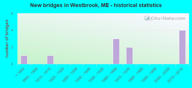
- New bridges - historical statistics
- 1Before 1900
- 11910-1919
- 31960-1969
- 21970-1979
- 42010-2019

- Reconstructed bridges - Historical Statistics
- 11950-1959
- 01960-1969
- 01970-1979
- 01980-1989
- 11990-1999


- Bridge Condition - Deck
- 50.0%Very good
- 25.0%Satisfactory
- 25.0%Fair

- Bridge Condition - Superstructure
- 50.0%Very good
- 25.0%Satisfactory
- 25.0%Poor

- Bridge Condition - Substructure
- 33.3%Very good
- 33.3%Satisfactory
- 33.3%Fair

- Bridge Condition - Channel
- 62.5%Very good
- 12.5%Satisfactory
- 25.0%Fair

- Bridge Condition - Culverts
- 20.0%Very good
- 20.0%Good
- 40.0%Satisfactory
- 20.0%Fair
Find on map >> Show street view
Location: .4 MI N JCT 25 (Lat: 0.001206, Lng: -110.185283), Year Built: 626 , Status: Open, Structure Length: 1.31m (4.30ft), Average Daily Traffic: 20 (year 0000), Average Future Daily Traffic: 18,794 (year 2034), Features Intersected: 82105CUMBERLAND ST.
Lanes on structure: 1, Lanes under structure: 90, Toll: On Interstate toll segment, Owner: County Highway Agency, Approaching Roadway Width: 0.00m, Skew: 80 degrees, Material/Design: Steel, Design/Construction: Girder and Floorbeam System, Number Of Spans In Main Unit: 1, Length of Maximum Span: 11.6m (38.1ft), Out-to-Out Width: 3.6m (11.8ft)
Condition: Substructure: Fair, Structural Evaluation: Somewhat better than minimum adequacy, Underclear: High priority of corrective action, Designated Inspection Frequency: Every 24 months, Inspection Date: May 2021
Find on map >> Show street view
Structure Number: 1519, Location: 0.1 MI W JCT RTE 25 (Lat: 43.683189, Lng: -70.352050), Route carried "on" structure: County highway , Year Built: 2014, Status: Open, Structure Length: 2.63m (8.63ft), Average Daily Traffic: 16,440 (year 2016), Truck Traffic: 5%, Average Future Daily Traffic: 23,016 (year 2036), Design Load: Greater than HL93, Features Intersected: PRESUMPSCOT RIVER, Facility Carried by Structure: CUMBERLAND STREET
Minimum Vertical Clearance: 30+ m (98+ ft), Kilometerpoint: 0.209, Lanes on structure: 2, Owner: State Highway Agency, Approaching Roadway Width: 9.8m (32.2ft), Material/Design: Steel, Design/Construction: Stringer/Multi-beam, Number Of Spans In Main Unit: 1, Length of Maximum Span: 24.7m (81.0ft), Curb or Sidewalk Widths: Left: 0.0m, Right: 1.8m (5.9ft), Curb-To-Curb Width: 9.8m (32.2ft), Out-to-Out Width: 12.6m (41.3ft)
Condition: Deck: Very good, Superstructure: Very good, Substructure: Very good, Channel: Very good, Operating Rating: 53.8 metric tons, Method Used To Determine Operating Rating: Load and Resistance Factor Rating (LRFR) rating reported by rating factor(RF) method using HL-93 loadings, Inventory Rating: 41.5 metric tons, Method Used To Determine Inventory Rating: Load and Resistance Factor Rating (LRFR) rating reported by rating factor(RF) method using HL-93 loadings, Structural Evaluation: Equal to present desirable criteria, Deck Geometry: Meets minimum limits, Waterway Adequacy: Equal to present desirable criteria, Approach Roadway Alignment: Equal to present desirable criteria, Designated Inspection Frequency: Every 24 months, Underwater Inspection Frequency: Every 60 months, Inspection Date: March 2021, Underwater Inspection Date: October 2021, Deck Structure Type: Concrete Cast-file-Place, Wearing Surface/Protective System: Wearing Surface: Bituminous, Membrane: Preformed Fabric
Find on map >> Show street view
Structure Number: 1545, Location: 0.5 MI S OF JCT RTE 25 (Lat: 43.672569, Lng: -70.349161), Route carried "on" structure: County highway , Year Built: 1976, Status: Open, Structure Length: 7.08m (23.23ft), Average Daily Traffic: 3,720 (year 2016), Truck Traffic: 5%, Average Future Daily Traffic: 5,208 (year 2036), Design Load: HS 20, Features Intersected: WESTBROOK ARTERIAL, Facility Carried by Structure: WOODLAWN AVENUE
Minimum Vertical Clearance: 30+ m (98+ ft), Kilometerpoint: 0.080, Lanes on structure: 2, Lanes under structure: 4, Owner: State Highway Agency, Approaching Roadway Width: 9.1m (29.9ft), Skew: 4 degrees, Material/Design: Steel continuous, Design/Construction: Stringer/Multi-beam, Number Of Spans In Main Unit: 2, Length of Maximum Span: 36.3m (119.1ft), Curb or Sidewalk Widths: Left: 0.2m (0.7ft), Right: 1.5m (4.9ft), Curb-To-Curb Width: 9.2m (30.2ft), Out-to-Out Width: 11.8m (38.7ft)
Condition: Deck: Satisfactory, Superstructure: Satisfactory, Substructure: Satisfactory, Operating Rating: 52.8 metric tons, Method Used To Determine Operating Rating: Load and Resistance Factor Rating (LRFR) rating reported by rating factor(RF) method using HL-93 loadings, Inventory Rating: 40.8 metric tons, Method Used To Determine Inventory Rating: Load and Resistance Factor Rating (LRFR) rating reported by rating factor(RF) method using HL-93 loadings, Structural Evaluation: Equal to present minimum criteria, Deck Geometry: Meets minimum limits, Underclear: Meets minimum limits, Approach Roadway Alignment: Better than present minimum criteria, Designated Inspection Frequency: Every 24 months, Inspection Date: August 2021, Deck Structure Type: Concrete Cast-file-Place, Wearing Surface/Protective System: Wearing Surface: Bituminous, Membrane: Built-up
Find on map >> Show street view
Structure Number: 1547, Location: .4 MI S JCT 25 (Lat: 43.673511, Lng: -70.351250), Year Built: 1975, Status: Open, Structure Length: 13.53m (44.39ft), Design Load: Pedestrian, Features Intersected: WESTBROOK ARTERIAL
Minimum Vertical Clearance: 2.44m (8.01ft), Lanes under structure: 4, Owner: State Highway Agency, Material/Design: Concrete continuous, Design/Construction: Box Beam or Girders - Single/Spread, Number Of Spans In Main Unit: 2, Number Of Approach Spans: 4, Length of Maximum Span: 29.0m (95.1ft), Curb-To-Curb Width: 2.4m (7.9ft), Out-to-Out Width: 2.8m (9.2ft)
Condition: Substructure: Satisfactory, Underclear: Meets minimum limits, Designated Inspection Frequency: Every 24 months, Inspection Date: August 2021
Find on map >> Show street view
Structure Number: 3467, Location: .9 MI S TOWNLINE (Lat: 43.741611, Lng: -70.353161), Route carried "on" structure: State highway 302, Year Built: 2011, Status: Open, Structure Length: 0.89m (2.92ft), Average Daily Traffic: 13,540 (year 2016), Truck Traffic: 5%, Average Future Daily Traffic: 18,956 (year 2036), Design Load: Greater than HL93, Features Intersected: MILL BROOK
Minimum Vertical Clearance: 30+ m (98+ ft), Kilometerpoint: 11.668, Lanes on structure: 2, Base Highway Network: Yes, Owner: State Highway Agency, Approaching Roadway Width: 9.4m (30.8ft), Skew: 1 degrees, Material/Design: Concrete, Design/Construction: Culvert, Number Of Spans In Main Unit: 2, Length of Maximum Span: 3.8m (12.5ft)
Condition: Channel: Very good, Culverts: Very good, Operating Rating: 53.5 metric tons, Method Used To Determine Operating Rating: Load and Resistance Factor Rating (LRFR) rating reported by rating factor(RF) method using HL-93 loadings, Inventory Rating: 41.1 metric tons, Method Used To Determine Inventory Rating: Load and Resistance Factor Rating (LRFR) rating reported by rating factor(RF) method using HL-93 loadings, Structural Evaluation: Equal to present desirable criteria, Waterway Adequacy: Better than present minimum criteria, Approach Roadway Alignment: Equal to present desirable criteria, Designated Inspection Frequency: Every 24 months, Inspection Date: August 2021
Find on map >> Show street view
Structure Number: 3987, Location: 0.1 MI SW JCT RTE 302 (Lat: 43.703311, Lng: -70.326311), Route carried "on" structure: County highway , Year Built: 2011, Status: Open, Structure Length: 0.88m (2.89ft), Average Daily Traffic: 4,321 (year 2016), Truck Traffic: 5%, Average Future Daily Traffic: 6,049 (year 2036), Design Load: Greater than HL93, Features Intersected: MILL BROOK, Facility Carried by Structure: EAST BRIDGE STREET
Minimum Vertical Clearance: 30+ m (98+ ft), Kilometerpoint: 3.718, Lanes on structure: 2, Owner: State Highway Agency, Approaching Roadway Width: 11.0m (36.1ft), Skew: 1 degrees, Material/Design: Concrete, Design/Construction: Culvert, Number Of Spans In Main Unit: 1, Length of Maximum Span: 8.2m (26.9ft)
Condition: Channel: Very good, Culverts: Good, Operating Rating: 82.0 metric tons, Method Used To Determine Operating Rating: Load and Resistance Factor Rating (LRFR) rating reported by rating factor(RF) method using HL-93 loadings, Inventory Rating: 63.2 metric tons, Method Used To Determine Inventory Rating: Load and Resistance Factor Rating (LRFR) rating reported by rating factor(RF) method using HL-93 loadings, Structural Evaluation: Better than present minimum criteria, Waterway Adequacy: Equal to present desirable criteria, Approach Roadway Alignment: Equal to present desirable criteria, Designated Inspection Frequency: Every 24 months, Inspection Date: December 2021
Find on map >> Show street view
Structure Number: 543, Location: 0.4 MI NW OF SACO STREET (Lat: 43.656300, Lng: -70.400689), Route carried "on" structure: County highway , Year Built: 1962, Status: Open, Structure Length: 0.91m (2.99ft), Average Daily Traffic: 4,528 (year 2016), Truck Traffic: 5%, Average Future Daily Traffic: 6,339 (year 2036), Design Load: H 20, Features Intersected: STROUDWATER RIVER, Facility Carried by Structure: BRACKET ROAD
Minimum Vertical Clearance: 30+ m (98+ ft), Kilometerpoint: 2.607, Lanes on structure: 2, Owner: State Highway Agency, Approaching Roadway Width: 9.4m (30.8ft), Skew: 2 degrees, Material/Design: Steel, Design/Construction: Culvert, Number Of Spans In Main Unit: 2, Length of Maximum Span: 4.1m (13.5ft)
Condition: Channel: Satisfactory, Culverts: Fair, Operating Rating: 97.2 metric tons, Method Used To Determine Operating Rating: Load and Resistance Factor Rating (LRFR) rating reported by rating factor(RF) method using HL-93 loadings, Inventory Rating: 82.0 metric tons, Method Used To Determine Inventory Rating: Load and Resistance Factor Rating (LRFR) rating reported by rating factor(RF) method using HL-93 loadings, Structural Evaluation: Somewhat better than minimum adequacy, Waterway Adequacy: Equal to present minimum criteria, Approach Roadway Alignment: Better than present minimum criteria, Designated Inspection Frequency: Every 24 months, Inspection Date: October 2021
Find on map >> Show street view
Structure Number: 5661, Location: 0.1 MI N JCT RTE 25 (Lat: 43.677711, Lng: -70.367031), Route carried "on" structure: County highway , Year Built: 2016, Status: Open, Structure Length: 4.88m (16.01ft), Average Daily Traffic: 10,340 (year 2016), Truck Traffic: 5%, Average Future Daily Traffic: 14,476 (year 2036), Design Load: H 20, Features Intersected: PRESUMPSCOT RIVER, Facility Carried by Structure: BRIDGE STREET
Minimum Vertical Clearance: 30+ m (98+ ft), Kilometerpoint: 1.481, Lanes on structure: 2, Owner: State Highway Agency, Approaching Roadway Width: 9.8m (32.2ft), Design/Construction: Stringer/Multi-beam, Number Of Spans In Main Unit: 2, Length of Maximum Span: 24.4m (80.1ft), Curb-To-Curb Width: 9.8m (32.2ft), Out-to-Out Width: 10.8m (35.4ft)
Condition: Deck: Very good, Superstructure: Very good, Substructure: Very good, Channel: Very good, Operating Rating: 43.4 metric tons, Method Used To Determine Operating Rating: Load and Resistance Factor Rating (LRFR) rating reported by rating factor(RF) method using HL-93 loadings, Inventory Rating: 33.4 metric tons, Method Used To Determine Inventory Rating: Load and Resistance Factor Rating (LRFR) rating reported by rating factor(RF) method using HL-93 loadings, Structural Evaluation: Equal to present desirable criteria, Deck Geometry: Meets minimum limits, Waterway Adequacy: Better than present minimum criteria, Approach Roadway Alignment: Equal to present desirable criteria, Designated Inspection Frequency: Every 24 months, Underwater Inspection Frequency: Every 60 months, Inspection Date: May 2021, Underwater Inspection Date: June 2018, Deck Structure Type: Other, Wearing Surface/Protective System: Wearing Surface: Bituminous, Membrane: Preformed Fabric
Find on map >> Show street view
Structure Number: 5749, Location: 150 FT S'LY OF PRIDE ST (Lat: 43.701911, Lng: -70.340711), Route carried "on" structure: City street , Year Built: 1960, Year Reconstructed: 2004, Status: Open, Structure Length: 0.79m (2.59ft), Average Daily Traffic: 2,851 (year 2016), Truck Traffic: 5%, Average Future Daily Traffic: 3,991 (year 2036), Design Load: H 20, Features Intersected: MILL BROOK, Facility Carried by Structure: AUSTIN STREET
Minimum Vertical Clearance: 30+ m (98+ ft), Kilometerpoint: 0.483, Lanes on structure: 2, Owner: State Highway Agency, Approaching Roadway Width: 8.5m (27.9ft), Skew: 1 degrees, Design/Construction: Culvert, Number Of Spans In Main Unit: 2, Length of Maximum Span: 3.2m (10.5ft)
Condition: Channel: Fair, Culverts: Satisfactory, Structural Evaluation: Equal to present minimum criteria, Waterway Adequacy: Equal to present minimum criteria, Approach Roadway Alignment: Better than present minimum criteria, Designated Inspection Frequency: Every 24 months, Inspection Date: October 2020
Find on map >> Show street view
Structure Number: 5751, Location: 1.2 MI S JCT RTE 25 (Lat: 43.660689, Lng: -70.361400), Route carried "on" structure: State highway , Year Built: 1916, Year Reconstructed: 1963, Status: Open, Structure Length: 1.04m (3.41ft), Average Daily Traffic: 11,740 (year 2016), Truck Traffic: 5%, Average Future Daily Traffic: 16,436 (year 2036), Design Load: H 20, Features Intersected: STROUDWATER RIVER, Facility Carried by Structure: SPRING STREET
Minimum Vertical Clearance: 30+ m (98+ ft), Kilometerpoint: 1.851, Lanes on structure: 2, Base Highway Network: Yes, Owner: State Highway Agency, Approaching Roadway Width: 9.8m (32.2ft), Material/Design: Concrete, Design/Construction: Slab, Number Of Spans In Main Unit: 1, Length of Maximum Span: 9.1m (29.9ft), Curb or Sidewalk Widths: Left: 0.5m (1.6ft), Right: 0.5m (1.6ft), Curb-To-Curb Width: 8.5m (27.9ft), Out-to-Out Width: 10.1m (33.1ft)
Condition: Deck: Fair, Superstructure: Poor, Substructure: Fair, Channel: Very good, Operating Rating: 42.8 metric tons, Method Used To Determine Operating Rating: Load and Resistance Factor Rating (LRFR) rating reported by rating factor(RF) method using HL-93 loadings, Inventory Rating: 33.0 metric tons, Method Used To Determine Inventory Rating: Load and Resistance Factor Rating (LRFR) rating reported by rating factor(RF) method using HL-93 loadings, Structural Evaluation: Meets minimum limits, Deck Geometry: High priority of replacement, Waterway Adequacy: Equal to present desirable criteria, Approach Roadway Alignment: Better than present minimum criteria, Designated Inspection Frequency: Every 24 months, Inspection Date: March 2021, Deck Structure Type: Concrete Cast-file-Place, Wearing Surface/Protective System: Wearing Surface: Bituminous
Find on map >> Show street view
Structure Number: 6045, Location: 0.6 MI S JCT RTE 25 (Lat: 43.667539, Lng: -70.373889), Route carried "on" structure: County highway , Year Built: 1966, Status: Open, Structure Length: 0.91m (2.99ft), Average Daily Traffic: 8,230 (year 2016), Truck Traffic: 5%, Average Future Daily Traffic: 11,522 (year 2036), Design Load: H 20, Features Intersected: STROUDWATER RIVER, Facility Carried by Structure: SACO STREET
Minimum Vertical Clearance: 30+ m (98+ ft), Kilometerpoint: 1.947, Lanes on structure: 2, Owner: State Highway Agency, Approaching Roadway Width: 10.1m (33.1ft), Skew: 3 degrees, Material/Design: Concrete, Design/Construction: Culvert, Number Of Spans In Main Unit: 1, Length of Maximum Span: 8.1m (26.6ft)
Condition: Channel: Fair, Culverts: Satisfactory, Operating Rating: 47.3 metric tons, Method Used To Determine Operating Rating: Load and Resistance Factor Rating (LRFR) rating reported by rating factor(RF) method using HL-93 loadings, Inventory Rating: 36.6 metric tons, Method Used To Determine Inventory Rating: Load and Resistance Factor Rating (LRFR) rating reported by rating factor(RF) method using HL-93 loadings, Structural Evaluation: Equal to present minimum criteria, Waterway Adequacy: Equal to present minimum criteria, Approach Roadway Alignment: Equal to present minimum criteria, Designated Inspection Frequency: Every 24 months, Inspection Date: October 2020
Find on map >> Show street view
Location: .4 MI N JCT 25 (Lat: 43.686044, Lng: -70.357119), Route carried "under" structure: Bypass State highway 2400, Structure Length: 0. m, Average Daily Traffic: 13,424 (year 2014), Truck Traffic: 5%, Features Intersected: CUMBERLAND ST., Facility Carried by Structure: MCRR
Minimum Vertical Clearance: 4.39m (14.40ft), Kilometerpoint: 0.740, Lanes on structure: 2, Length of Maximum Span: 0.0m
Find on map >> Show street view
Location: .3 MI S WESTBROOK ST (Lat: 43.682119, Lng: -70.356125), Route carried "under" structure: Bypass State highway 12500, Structure Length: 0. m, Average Daily Traffic: 2,496 (year 2014), Truck Traffic: 5%, Features Intersected: BROWN STREET, Facility Carried by Structure: MAINE CENTRAL RAIL
Minimum Vertical Clearance: 3.50m (11.48ft), Kilometerpoint: 0.177, Lanes on structure: 2, Length of Maximum Span: 0.0m
Find on map >> Show street view
Location: 0.2 MI W OF JCT RTE US 1 (Lat: 43.742275, Lng: -70.319839), Route carried "under" structure: State lands road 22310, Structure Length: 0. m, Average Daily Traffic: 27,050 (year 2014), Truck Traffic: 11%, Features Intersected: JOHNSON ROAD, Facility Carried by Structure: INTERSTATE 295
Minimum Vertical Clearance: 4.80m (15.75ft), Kilometerpoint: 18.990, Lanes on structure: 4, Length of Maximum Span: 0.0m