Gonic neighborhood in Barrington, New Hampshire (NH), 03839, 03867, 03825 detailed profile
Settings
X


Business Search - 14 Million verified businesses
Area: 21.962 square miles
Population: 9,355
Population density:
| Gonic: | 426 people per square mile |
| Barrington: | 160 people per square mile |

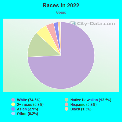
- 8,08174.3%White
- 1,36312.5%Native Hawaiian and Other
Pacific Islander - 6255.8%Two or more races
- 4123.8%Hispanic or Latino
- 2282.1%Asian
- 1411.3%Black
- 190.2%Some other race
Median household income in 2022:
| Gonic: | $115,096 |
| New Hampshire: | $89,992 |
Distribution of median household income
![Distribution of median household income]()
- 191Less than $10,000
- 255$10,000 to $19,999
- 353$20,000 to $29,999
- 180$30,000 to $39,999
- 292$40,000 to $49,999
- 264$50,000 to $59,999
- 381$60,000 to $74,999
- 589$75,000 to $99,999
- 621$100,000 to $124,999
- 446$125,000 to $149,999
- 693$150,000 to $199,999
- 138$200,000 or more

Distribution of owner-occupied house/condo value
![Distribution of owner-occupied house/condo value]()
- 1,247Less than $50,000
- 732$50,000 to $99,999
- 190$100,000 to $149,999
- 269$150,000 to $199,999
- 679$200,000 to $249,999
- 346$250,000 to $299,999
- 527$300,000 to $399,999
- 225$400,000 to $499,999
- 128$500,000 to $749,999
- 77$750,000 to $999,999
- 77$1,000,000 or more

Distribution of rent paid by renters
![Distribution of rent paid by renters]()
- 125Less than $100
- 127$100 to $199
- 54$200 to $299
- 69$300 to $399
- 100$400 to $499
- 175$500 to $599
- 196$600 to $699
- 576$700 to $799
- 97$800 to $899
- 186$900 to $999
- 445$1,000 to $1,249
- 424$1,250 to $1,499
- 226$1,500 to $1,999
- 121$2,000 or more

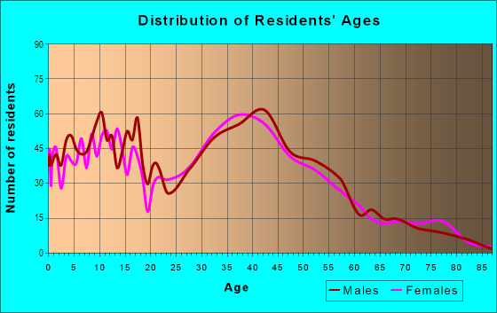
| Males: | 4,769 |
| Females: | 4,585 |
| Males: | 43.7 years |
| Females: | 43.1 years |
Average household size:
| Gonic: | 2.5 people |
| New Hampshire: | 2.4 people |
Percentage of family households:
| Gonic: | 50.6% |
| New Hampshire: | 44.2% |
| Here: | 44.6% |
| New Hampshire: | 51.2% |
Percentage of married-couple families with children (among all households):
| Gonic: | 29.4% |
| New Hampshire: | 53.1% |
Percentage of single-mother households (among all households):
| Gonic: | 7.7% |
| New Hampshire: | 6.6% |
Percentage of never married males 15 years old and over:
Percentage of never married females 15 years old and over:
| Gonic: | 18.7% |
| New Hampshire: | 17.0% |
Percentage of never married females 15 years old and over:
| Gonic: | 13.6% |
| New Hampshire: | 13.6% |
Percentage of people that speak English not well or not at all:
| Gonic: | 0.4% |
| New Hampshire: | 1.0% |
Percentage of people born in this state:
Percentage of people born in another U.S. state:
Percentage of native residents but born outside the U.S.:
Percentage of foreign born residents:
| Here: | 51.1% |
| New Hampshire: | 41.1% |
Percentage of people born in another U.S. state:
| Gonic: | 44.9% |
| New Hampshire: | 51.5% |
Percentage of native residents but born outside the U.S.:
| Here: | 0.7% |
| New Hampshire: | 1.2% |
Percentage of foreign born residents:
| Here: | 3.3% |
| New Hampshire: | 6.2% |
Owner-occupied
Renter-occupied

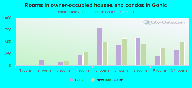
- Rooms in owner-occupied houses and condos in Gonic
- 191 room
- 1252 rooms
- 833 rooms
- 2204 rooms
- 7955 rooms
- 4316 rooms
- 5727 rooms
- 2038 rooms
- 3359+ rooms

- Rooms in renter-occupied apartments in Gonic
- 401 room
- 1552 rooms
- 2353 rooms
- 4104 rooms
- 3395 rooms
- 1296 rooms
- 817 rooms
- 518 rooms
- 339+ rooms
Owner-occupied
Renter-occupied
- Bedrooms in owner-occupied houses and condos in Gonic
- 45no bedroom
- 81 bedroom
- 5492 bedrooms
- 1,5643 bedrooms
- 4124 bedrooms
- 485+ bedrooms
- Bedrooms in renter-occupied apartments in Gonic
- 40no bedroom
- 3981 bedroom
- 6492 bedrooms
- 1983 bedrooms
- 524 bedrooms
- 385+ bedrooms
Average number of cars or other vehicles available in houses/condos:
Average number of cars or other vehicles available in apartments:
| This neighborhood: | 2.1 |
| New Hampshire: | 2.1 |
Average number of cars or other vehicles available in apartments:
| Here: | 1.5 |
| New Hampshire: | 1.4 |
Percentage of units with a mortgage:
| Gonic: | 58.9% |
| New Hampshire: | 61.2% |
Average estimated value of detached houses in 2022 (48.4% of all units):
| Gonic: | $300,416 |
| New Hampshire: | $491,479 |
- Year house built in Gonic
- 1,4882020 or later
- 3762010 to 2019
- 8932000 to 2009
- 4111990 to 1999
- 7621980 to 1989
- 6141970 to 1979
- 5411960 to 1969
- 3091950 to 1959
- 641940 to 1949
- 4841939 or earlier
City-data.com crime index for town in 2020 (higher means more crime):
| City: | 31.6 |
| U.S. average: | 219.5 |
Travel time to work (commute)
![Travel time to work (commute)]()
- 14Less than 5 minutes
- 3265 to 9 minutes
- 59310 to 14 minutes
- 1,16315 to 19 minutes
- 61020 to 24 minutes
- 31625 to 29 minutes
- 69830 to 34 minutes
- 11135 to 39 minutes
- 16240 to 44 minutes
- 39145 to 59 minutes
- 27360 to 89 minutes
- 11790 or more minutes

Means of transportation to work
![Means of transportation to work]()
- 79.0%4,054Drove a car alone
- 7.5%385Carpooled
- 1.3%66Bus
- 0.8%41Long-distance train or commuter rail
- 0.9%45Taxi
- 0.3%16Bicycle
- 0.3%16Walked
- 4.3%220Other means
- 10.1%517Worked at home

Time leaving home to go to work
![Time leaving home to go to work]()
- 29612:00 a.m. to 4:59 a.m.
- 1045:00 a.m. to 5:29 a.m.
- 4225:30 a.m. to 5:59 a.m.
- 4566:00 a.m. to 6:29 a.m.
- 4996:30 a.m. to 6:59 a.m.
- 5527:00 a.m. to 7:29 a.m.
- 5547:30 a.m. to 7:59 a.m.
- 3528:00 a.m. to 8:29 a.m.
- 1258:30 a.m. to 8:59 a.m.
- 1949:00 a.m. to 9:59 a.m.
- 8010:00 a.m. to 10:59 a.m.
- 2511:00 a.m. to 11:59 a.m.
- 64712:00 p.m. to 3:59 p.m.
- 4624:00 p.m. to 11:59 p.m.

Occupations of males:
- Percentage of males in management occupations (except farmers):
Here: 4.0% New Hampshire: 13.0%
- Percentage of males in business and financial operations occupations:
Here: 2.8% New Hampshire: 4.9%
- Percentage of males in computer and mathematical occupations:
Here: 2.6% New Hampshire: 5.6%
- Percentage of males in architecture and engineering occupations:
Here: 8.9% New Hampshire: 5.1%
- Percentage of males in education, training, and library occupations:
Here: 1.4% New Hampshire: 3.3%
- Percentage of males in service occupations:
Here: 17.6% New Hampshire: 12.1%
- Percentage of males in sales and office occupations:
Here: 13.0% New Hampshire: 15.3%
- Percentage of males in construction, extraction, and maintenance occupations:
Here: 17.2% New Hampshire: 9.5%
- Percentage of males in production occupations:
Here: 16.3% New Hampshire: 8.3%
- Percentage of males in transportation occupations:
Here: 6.0% New Hampshire: 4.8%
- Percentage of males in material moving occupations:
Here: 3.7% New Hampshire: 3.9%
Occupations of females:
- Percentage of females in management occupations (except farmers):
Here: 9.6% New Hampshire: 10.8%
- Percentage of females in business and financial operations occupations:
Here: 6.2% New Hampshire: 6.7%
- Percentage of females in computer and mathematical occupations:
Here: 2.4% New Hampshire: 2.3%
- Percentage of females in community and social services occupations:
Here: 5.1% New Hampshire: 2.4%
- Percentage of females in education, training, and library occupations:
Here: 9.4% New Hampshire: 10.0%
- Percentage of females in arts, design, entertainment, sports, and media occupations:
Here: 6.3% New Hampshire: 1.8%
- Percentage of females in healthcare practitioners and technical occupations:
Here: 12.7% New Hampshire: 10.8%
- Percentage of females in service occupations:
Here: 14.1% New Hampshire: 18.4%
- Percentage of females in sales and office occupations:
Here: 23.5% New Hampshire: 26.6%
- Percentage of females in production occupations:
Here: 3.1% New Hampshire: 3.9%
- Percentage of females in transportation occupations:
Here: 5.0% New Hampshire: 0.9%
- Percentage of females in material moving occupations:
Here: 1.4% New Hampshire: 1.6%
Percentage of people 16-64 in Armed Forces:
| Gonic: | 0.2% |
| New Hampshire: | 0.2% |
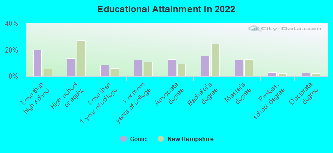
Education in this neighborhood (subdivision or community):
- Percentage of people 3 years and older in K-12 schools:
Gonic: 19.8% New Hampshire: 13.9%
- Percentage of people 3 years and older in undergraduate colleges:
Gonic: 5.5% New Hampshire: 4.1%
- Percentage of people 3 years and older in grad. or professional schools:
Gonic: 1.1% New Hampshire: 1.2%
- Percentage of students K-12 enrolled in private schools:
Gonic: 38.5% New Hampshire: 13.1%
Percentage of population below poverty level:
| Gonic: | 10.9% |
| New Hampshire: | 7.2% |
Median year owner moved in (as recorded in 2022):
| Gonic: | 2008 |
| New Hampshire: | 2010 |
Percentage of married-couple families with both working:
| Gonic: | 78.8% |
| New Hampshire: | 80.2% |
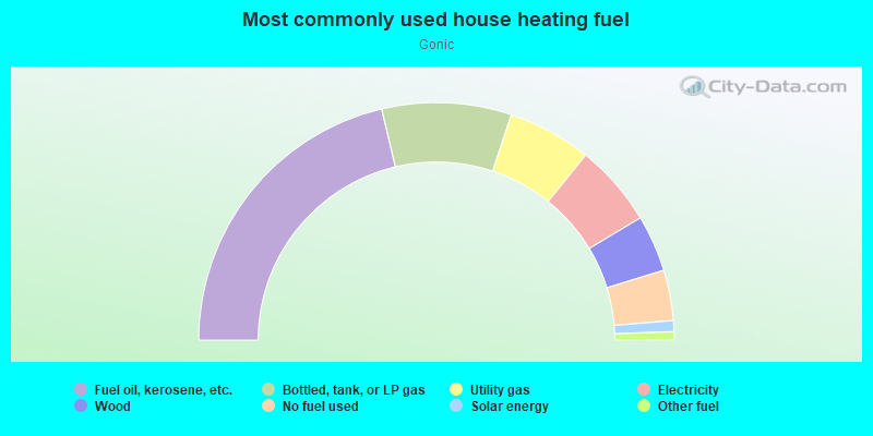
- 42.6%Fuel oil, kerosene, etc.
- 17.6%Bottled, tank, or LP gas
- 11.4%Utility gas
- 11.2%Electricity
- 7.7%Wood
- 6.9%No fuel used
- 1.5%Solar energy
- 1.1%Other fuel
Limited-access highways (interstate or state) in this neighborhood:
State Rte 16 (Spaulding Tpke)
Length: 6.38 miles
Directions: E-W, SE-NW
Directions: E-W, SE-NW
Highways in this neighborhood:
Calef Hwy (State Rte 125)
Length: 3.04 miles
Directions: N-S, SE-NW, SW-NE
Address range: 6 to 599
Directions: N-S, SE-NW, SW-NE
Address range: 6 to 599
State Rte 125 (Gonic Rd)
Length: 2.05 miles
Directions: N-S, SE-NW, SW-NE
Address range: 1 to 299
Directions: N-S, SE-NW, SW-NE
Address range: 1 to 299
Washington St (US Hwy 202)
Length: 0.84 miles
Directions: N-S, SW-NE
Address range: 202 to 374
Directions: N-S, SW-NE
Address range: 202 to 374
US Hwy 202
Length: 0.82 miles
Directions: E-W, N-S, SW-NE
Address range: 614 to 799
Directions: E-W, N-S, SW-NE
Address range: 614 to 799
State Rte 9
Length: 0.48 miles
Directions: E-W, SE-NW
Address range: 224 to 405
Directions: E-W, SE-NW
Address range: 224 to 405
State Rte 9 (Littleworth Rd)
Length: 0.03 miles
Directions: E-W, SE-NW
Address range: 143 to 165
Directions: E-W, SE-NW
Address range: 143 to 165
Roads and streets:
Scruton Pond Rd
Length: 4.61 miles
Directions: E-W, SE-NW, SW-NE
Address range: 39 to 393
Directions: E-W, SE-NW, SW-NE
Address range: 39 to 393
Pickering Rd
Length: 3.60 miles
Directions: E-W, N-S, SE-NW, SW-NE
Address range: 1 to 599
Directions: E-W, N-S, SE-NW, SW-NE
Address range: 1 to 599
Green Hill Rd
Length: 3.11 miles
Directions: E-W, SE-NW
Address range: 1 to 299
Directions: E-W, SE-NW
Address range: 1 to 299
Tolend Rd
Length: 2.63 miles
Directions: E-W, N-S, SE-NW
Address range: 1 to 227
Directions: E-W, N-S, SE-NW
Address range: 1 to 227
Rochester Neck Rd
Length: 2.31 miles
Directions: E-W, N-S, SE-NW
Address range: 1 to 249
Directions: E-W, N-S, SE-NW
Address range: 1 to 249
Gear Rd
Length: 2.11 miles
Directions: E-W, SE-NW
Address range: 1 to 163
Directions: E-W, SE-NW
Address range: 1 to 163
Hansonville Rd
Length: 2.03 miles
Directions: N-S, SW-NE
Address range: 1 to 198
Directions: N-S, SW-NE
Address range: 1 to 198
Brewster Rd
Length: 1.88 miles
Directions: N-S, SE-NW, SW-NE
Address range: 1 to 199
Directions: N-S, SE-NW, SW-NE
Address range: 1 to 199
Flagg Rd
Length: 1.82 miles
Directions: E-W, SE-NW
Address range: 1 to 161
Directions: E-W, SE-NW
Address range: 1 to 161
Oak St
Length: 1.76 miles
Direction: E-W
Address range: 1 to 199
Direction: E-W
Address range: 1 to 199
Smoke St
Length: 1.60 miles
Directions: E-W, SE-NW, SW-NE
Address range: 1 to 223
Directions: E-W, SE-NW, SW-NE
Address range: 1 to 223
Blackwater Rd
Length: 1.51 miles
Directions: E-W, SE-NW
Address range: 1 to 208
Directions: E-W, SE-NW
Address range: 1 to 208
Stillwater Cir
Length: 1.19 miles
Directions: E-W, SE-NW, SW-NE
Address range: 1 to 199
Directions: E-W, SE-NW, SW-NE
Address range: 1 to 199
Waterhouse Rd
Length: 1.16 miles
Directions: N-S, SW-NE
Address range: 43 to 63
Directions: N-S, SW-NE
Address range: 43 to 63
Ledgeview Dr
Length: 1.13 miles
Directions: E-W, N-S, SE-NW, SW-NE
Address range: 1 to 499
Directions: E-W, N-S, SE-NW, SW-NE
Address range: 1 to 499
Oak Hill Rd
Length: 1.13 miles
Directions: E-W, N-S, SE-NW, SW-NE
Address range: 8 to 147
Directions: E-W, N-S, SE-NW, SW-NE
Address range: 8 to 147
Substitute Rd
Length: 1.12 miles
Directions: E-W, SE-NW
Directions: E-W, SE-NW
Chesley Hill Rd
Length: 1.08 miles
Directions: E-W, N-S, SE-NW, SW-NE
Address range: 1 to 99
Directions: E-W, N-S, SE-NW, SW-NE
Address range: 1 to 99
England Rd
Length: 0.99 miles
Directions: N-S, SW-NE
Address range: 84 to 233
Directions: N-S, SW-NE
Address range: 84 to 233
Province Ln
Length: 0.94 miles
Directions: E-W, N-S, SE-NW, SW-NE
Address range: 1 to 62
Directions: E-W, N-S, SE-NW, SW-NE
Address range: 1 to 62
Chesley Dr
Length: 0.94 miles
Directions: E-W, SW-NE
Address range: 1 to 33
Directions: E-W, SW-NE
Address range: 1 to 33
Atwood Rd
Length: 0.91 miles
Directions: E-W, SE-NW, SW-NE
Address range: 1 to 66
Directions: E-W, SE-NW, SW-NE
Address range: 1 to 66
Grove St
Length: 0.81 miles
Directions: E-W, SE-NW
Address range: 1 to 99
Directions: E-W, SE-NW
Address range: 1 to 99
Old Green Hill Rd
Length: 0.80 miles
Directions: E-W, SE-NW
Address range: 1 to 99
Directions: E-W, SE-NW
Address range: 1 to 99
Deer Ridge Rd
Length: 0.78 miles
Directions: E-W, N-S, SE-NW, SW-NE
Address range: 2 to 99
Directions: E-W, N-S, SE-NW, SW-NE
Address range: 2 to 99
Estes Rd
Length: 0.76 miles
Directions: N-S, SE-NW
Address range: 1 to 63
Directions: N-S, SE-NW
Address range: 1 to 63
Blue Hills Dr
Length: 0.72 miles
Directions: E-W, N-S, SE-NW, SW-NE
Address range: 23 to 99
Directions: E-W, N-S, SE-NW, SW-NE
Address range: 23 to 99
Jessica Dr
Length: 0.72 miles
Directions: E-W, N-S, SE-NW, SW-NE
Address range: 2 to 99
Directions: E-W, N-S, SE-NW, SW-NE
Address range: 2 to 99
Church St
Length: 0.71 miles
Directions: E-W, N-S, SE-NW, SW-NE
Address range: 1 to 199
Directions: E-W, N-S, SE-NW, SW-NE
Address range: 1 to 199
State Rte 126 (Locke Hill Ln)
Length: 0.69 miles
Direction: SE-NW
Address range: 20 to 130
Direction: SE-NW
Address range: 20 to 130
Dry Hill Rd
Length: 0.68 miles
Directions: E-W, SE-NW
Address range: 3 to 53
Directions: E-W, SE-NW
Address range: 3 to 53
Darby Ln
Length: 0.64 miles
Directions: E-W, N-S, SE-NW, SW-NE
Address range: 1 to 56
Directions: E-W, N-S, SE-NW, SW-NE
Address range: 1 to 56
Muchardo Dr
Length: 0.64 miles
Directions: E-W, N-S, SE-NW, SW-NE
Address range: 1 to 27
Directions: E-W, N-S, SE-NW, SW-NE
Address range: 1 to 27
Benajah Rd
Length: 0.63 miles
Directions: E-W, N-S, SE-NW, SW-NE
Address range: 1 to 35
Directions: E-W, N-S, SE-NW, SW-NE
Address range: 1 to 35
Ridgewood Dr
Length: 0.61 miles
Directions: E-W, N-S, SE-NW, SW-NE
Address range: 1 to 20
Directions: E-W, N-S, SE-NW, SW-NE
Address range: 1 to 20
Mahala Way
Length: 0.60 miles
Directions: E-W, N-S, SE-NW, SW-NE
Address range: 1 to 37
Directions: E-W, N-S, SE-NW, SW-NE
Address range: 1 to 37
Railroad Ave
Length: 0.59 miles
Directions: E-W, SW-NE
Address range: 3 to 199
Directions: E-W, SW-NE
Address range: 3 to 199
Jonathan Ave
Length: 0.58 miles
Directions: E-W, N-S, SE-NW, SW-NE
Address range: 1 to 99
Directions: E-W, N-S, SE-NW, SW-NE
Address range: 1 to 99
Castle Rock Rd
Length: 0.53 miles
Directions: E-W, N-S, SE-NW, SW-NE
Address range: 7 to 48
Directions: E-W, N-S, SE-NW, SW-NE
Address range: 7 to 48
Kipling Rock Rd
Length: 0.52 miles
Directions: E-W, N-S, SE-NW, SW-NE
Address range: 1 to 99
Directions: E-W, N-S, SE-NW, SW-NE
Address range: 1 to 99
Main St
Length: 0.52 miles
Directions: E-W, N-S, SE-NW, SW-NE
Address range: 1 to 107
Directions: E-W, N-S, SE-NW, SW-NE
Address range: 1 to 107
Crissy Cir
Length: 0.51 miles
Directions: E-W, N-S, SE-NW, SW-NE
Address range: 1 to 99
Directions: E-W, N-S, SE-NW, SW-NE
Address range: 1 to 99
Country Brook Ests
Length: 0.50 miles
Directions: E-W, N-S, SE-NW, SW-NE
Address range: 1 to 72
Directions: E-W, N-S, SE-NW, SW-NE
Address range: 1 to 72
Heights Rd
Length: 0.48 miles
Directions: E-W, N-S, SE-NW, SW-NE
Address range: 2 to 6
Directions: E-W, N-S, SE-NW, SW-NE
Address range: 2 to 6
Tebbets Rd
Length: 0.47 miles
Directions: E-W, SW-NE
Address range: 1 to 38
Directions: E-W, SW-NE
Address range: 1 to 38
Lilypond Rd
Length: 0.47 miles
Directions: E-W, N-S, SE-NW, SW-NE
Address range: 2 to 44
Directions: E-W, N-S, SE-NW, SW-NE
Address range: 2 to 44
Glen Hill Rd
Length: 0.46 miles
Directions: N-S, SW-NE
Address range: 55 to 199
Directions: N-S, SW-NE
Address range: 55 to 199
Loring Dr
Length: 0.44 miles
Directions: E-W, N-S, SE-NW, SW-NE
Address range: 1 to 99
Directions: E-W, N-S, SE-NW, SW-NE
Address range: 1 to 99
Halcyn Hill
Length: 0.42 miles
Directions: E-W, N-S, SE-NW, SW-NE
Address range: 1 to 15
Directions: E-W, N-S, SE-NW, SW-NE
Address range: 1 to 15
Town Farm Rd
Length: 0.42 miles
Directions: E-W, N-S, SE-NW, SW-NE
Address range: 642 to 669
Directions: E-W, N-S, SE-NW, SW-NE
Address range: 642 to 669
Taylor Dr
Length: 0.39 miles
Directions: E-W, N-S, SE-NW, SW-NE
Directions: E-W, N-S, SE-NW, SW-NE
Juniper Ln
Length: 0.39 miles
Directions: E-W, N-S, SE-NW, SW-NE
Address range: 2 to 14
Directions: E-W, N-S, SE-NW, SW-NE
Address range: 2 to 14
Leeanna Dr
Length: 0.39 miles
Directions: E-W, N-S, SW-NE
Address range: 1 to 39
Directions: E-W, N-S, SW-NE
Address range: 1 to 39
Sugar Brook Rd
Length: 0.37 miles
Directions: E-W, N-S, SE-NW, SW-NE
Address range: 1 to 99
Directions: E-W, N-S, SE-NW, SW-NE
Address range: 1 to 99
Cemetery Rd
Length: 0.37 miles
Direction: SW-NE
Address range: 1 to 99
Direction: SW-NE
Address range: 1 to 99
Shady Hill Rd
Length: 0.37 miles
Directions: E-W, N-S, SE-NW, SW-NE
Directions: E-W, N-S, SE-NW, SW-NE
Efab Ln
Length: 0.37 miles
Direction: SW-NE
Direction: SW-NE
Chapman Dr
Length: 0.36 miles
Directions: N-S, SE-NW
Address range: 2 to 99
Directions: N-S, SE-NW
Address range: 2 to 99
Mavis Ave
Length: 0.36 miles
Directions: E-W, N-S, SE-NW, SW-NE
Address range: 1 to 45
Directions: E-W, N-S, SE-NW, SW-NE
Address range: 1 to 45
Justin Ln
Length: 0.35 miles
Directions: E-W, N-S, SE-NW, SW-NE
Address range: 12 to 26
Directions: E-W, N-S, SE-NW, SW-NE
Address range: 12 to 26
Forest Brook Dr
Length: 0.34 miles
Directions: E-W, N-S, SE-NW
Address range: 1 to 10
Directions: E-W, N-S, SE-NW
Address range: 1 to 10
Reagan Dr
Length: 0.33 miles
Directions: E-W, SW-NE
Address range: 2 to 99
Directions: E-W, SW-NE
Address range: 2 to 99
Brickyard Dr
Length: 0.32 miles
Directions: N-S, SW-NE
Address range: 5 to 99
Directions: N-S, SW-NE
Address range: 5 to 99
Caroon Way
Length: 0.31 miles
Directions: E-W, N-S, SW-NE
Directions: E-W, N-S, SW-NE
Wellington Dr
Length: 0.30 miles
Directions: E-W, N-S, SE-NW, SW-NE
Directions: E-W, N-S, SE-NW, SW-NE
D'Amours Ave
Length: 0.30 miles
Directions: E-W, SW-NE
Address range: 1 to 38
Directions: E-W, SW-NE
Address range: 1 to 38
Colonial Dr
Length: 0.29 miles
Directions: E-W, N-S, SE-NW
Address range: 1 to 99
Directions: E-W, N-S, SE-NW
Address range: 1 to 99
Echo Brook Rd
Length: 0.27 miles
Direction: SW-NE
Address range: 1 to 99
Direction: SW-NE
Address range: 1 to 99
Barrington Ln
Length: 0.26 miles
Directions: N-S, SW-NE
Address range: 1 to 37
Directions: N-S, SW-NE
Address range: 1 to 37
Kelly Ln
Length: 0.25 miles
Directions: N-S, SE-NW, SW-NE
Address range: 1 to 11
Directions: N-S, SE-NW, SW-NE
Address range: 1 to 11
Forest Meadows
Length: 0.25 miles
Direction: SW-NE
Address range: 1 to 99
Direction: SW-NE
Address range: 1 to 99
Stonewall Rd
Length: 0.25 miles
Directions: E-W, N-S, SE-NW, SW-NE
Address range: 1 to 12
Directions: E-W, N-S, SE-NW, SW-NE
Address range: 1 to 12
Stanley Ln
Length: 0.25 miles
Direction: SW-NE
Address range: 1 to 14
Direction: SW-NE
Address range: 1 to 14
Brentwood
Length: 0.24 miles
Directions: E-W, N-S, SE-NW
Directions: E-W, N-S, SE-NW
Barrington E
Length: 0.23 miles
Directions: E-W, N-S, SE-NW, SW-NE
Address range: 3 to 14
Directions: E-W, N-S, SE-NW, SW-NE
Address range: 3 to 14
Carr Dr
Length: 0.23 miles
Directions: E-W, N-S, SE-NW, SW-NE
Directions: E-W, N-S, SE-NW, SW-NE
Huckins Ln
Length: 0.23 miles
Directions: E-W, N-S, SE-NW
Address range: 1 to 99
Directions: E-W, N-S, SE-NW
Address range: 1 to 99
Henry Dr
Length: 0.22 miles
Directions: E-W, N-S, SE-NW
Address range: 1 to 22
Directions: E-W, N-S, SE-NW
Address range: 1 to 22
Rudman Dr
Length: 0.22 miles
Directions: E-W, SE-NW, SW-NE
Address range: 1 to 65
Directions: E-W, SE-NW, SW-NE
Address range: 1 to 65
Kennedy Ave
Length: 0.21 miles
Directions: N-S, SE-NW, SW-NE
Address range: 1 to 99
Directions: N-S, SE-NW, SW-NE
Address range: 1 to 99
Stanley Pond Dr
Length: 0.20 miles
Directions: E-W, N-S, SE-NW, SW-NE
Address range: 1 to 99
Directions: E-W, N-S, SE-NW, SW-NE
Address range: 1 to 99
Taylor Ave
Length: 0.20 miles
Direction: SW-NE
Direction: SW-NE
Nadeau Dr
Length: 0.20 miles
Direction: SW-NE
Address range: 1 to 99
Direction: SW-NE
Address range: 1 to 99
Shady Hill Dr
Length: 0.20 miles
Direction: SW-NE
Address range: 1 to 99
Direction: SW-NE
Address range: 1 to 99
Brook Farm Village
Length: 0.20 miles
Directions: E-W, N-S, SE-NW, SW-NE
Address range: 2 to 91
Directions: E-W, N-S, SE-NW, SW-NE
Address range: 2 to 91
Landry Ln
Length: 0.18 miles
Directions: E-W, N-S, SE-NW, SW-NE
Address range: 1 to 99
Directions: E-W, N-S, SE-NW, SW-NE
Address range: 1 to 99
Cross Ln
Length: 0.16 miles
Directions: E-W, SE-NW
Address range: 1 to 10
Directions: E-W, SE-NW
Address range: 1 to 10
Aspen Ln
Length: 0.16 miles
Direction: N-S
Address range: 1 to 99
Direction: N-S
Address range: 1 to 99
Dyment Way
Length: 0.16 miles
Directions: E-W, SE-NW
Directions: E-W, SE-NW
Stroud Ln
Length: 0.16 miles
Directions: N-S, SW-NE
Address range: 1 to 9
Directions: N-S, SW-NE
Address range: 1 to 9
Harding St (Patriots Way)
Length: 0.15 miles
Directions: N-S, SW-NE
Address range: 1 to 99
Directions: N-S, SW-NE
Address range: 1 to 99
Bunker Dr
Length: 0.15 miles
Direction: SE-NW
Address range: 1 to 99
Direction: SE-NW
Address range: 1 to 99
Baskerville Dr
Length: 0.15 miles
Directions: E-W, N-S, SE-NW, SW-NE
Directions: E-W, N-S, SE-NW, SW-NE
Sherman St
Length: 0.15 miles
Directions: N-S, SW-NE
Address range: 1 to 99
Directions: N-S, SW-NE
Address range: 1 to 99
Politic Dr
Length: 0.14 miles
Directions: E-W, N-S, SE-NW, SW-NE
Address range: 1 to 18
Directions: E-W, N-S, SE-NW, SW-NE
Address range: 1 to 18
Park Ln
Length: 0.14 miles
Directions: N-S, SW-NE
Address range: 1 to 8
Directions: N-S, SW-NE
Address range: 1 to 8
Spirit Creek Rd
Length: 0.14 miles
Directions: N-S, SW-NE
Address range: 1 to 99
Directions: N-S, SW-NE
Address range: 1 to 99
Limanni Rd
Length: 0.14 miles
Directions: E-W, N-S, SE-NW, SW-NE
Directions: E-W, N-S, SE-NW, SW-NE
Pawtucketts Way
Length: 0.13 miles
Directions: E-W, SW-NE
Address range: 1 to 99
Directions: E-W, SW-NE
Address range: 1 to 99
Paradise Park Rd
Length: 0.12 miles
Direction: SE-NW
Direction: SE-NW
Amy's Ln
Length: 0.12 miles
Directions: E-W, SE-NW
Address range: 1 to 6
Directions: E-W, SE-NW
Address range: 1 to 6
Norman St
Length: 0.12 miles
Direction: SE-NW
Address range: 1 to 19
Direction: SE-NW
Address range: 1 to 19
Donald St
Length: 0.12 miles
Direction: SW-NE
Address range: 1 to 99
Direction: SW-NE
Address range: 1 to 99
Felker St
Length: 0.12 miles
Direction: E-W
Address range: 1 to 22
Direction: E-W
Address range: 1 to 22
Greenhill Mhp
Length: 0.11 miles
Directions: E-W, N-S, SW-NE
Directions: E-W, N-S, SW-NE
White Birch Ln
Length: 0.11 miles
Direction: N-S
Address range: 1 to 99
Direction: N-S
Address range: 1 to 99
Pumpkin Hollow
Length: 0.11 miles
Direction: SE-NW
Direction: SE-NW
Lamy Rd
Length: 0.11 miles
Directions: N-S, SE-NW
Address range: 1 to 99
Directions: N-S, SE-NW
Address range: 1 to 99
Aspen Ct
Length: 0.11 miles
Direction: SE-NW
Address range: 1 to 11
Direction: SE-NW
Address range: 1 to 11
Anctil Ct
Length: 0.11 miles
Directions: E-W, N-S
Address range: 1 to 106
Directions: E-W, N-S
Address range: 1 to 106
Rudman Cir
Length: 0.09 miles
Directions: SE-NW, SW-NE
Directions: SE-NW, SW-NE
Old Tebbetts Rd
Length: 0.09 miles
Direction: SW-NE
Address range: 1 to 99
Direction: SW-NE
Address range: 1 to 99
Century Pines Dr
Length: 0.09 miles
Directions: E-W, N-S, SE-NW, SW-NE
Address range: 1 to 17
Directions: E-W, N-S, SE-NW, SW-NE
Address range: 1 to 17
Stephen James Rd
Length: 0.09 miles
Direction: SE-NW
Address range: 6 to 9
Direction: SE-NW
Address range: 6 to 9
Ramsey Rd
Length: 0.09 miles
Directions: N-S, SW-NE
Address range: 1 to 3
Directions: N-S, SW-NE
Address range: 1 to 3
Durham Ln
Length: 0.08 miles
Direction: N-S
Address range: 1 to 17
Direction: N-S
Address range: 1 to 17
Grey Ledge Dr
Length: 0.08 miles
Directions: N-S, SW-NE
Address range: 1 to 99
Directions: N-S, SW-NE
Address range: 1 to 99
Aspen Dr
Length: 0.07 miles
Directions: E-W, N-S, SE-NW, SW-NE
Directions: E-W, N-S, SE-NW, SW-NE
School St (Shelby Ln)
Length: 0.07 miles
Direction: E-W
Address range: 1 to 99
Direction: E-W
Address range: 1 to 99
Oakhill Rd
Length: 0.06 miles
Direction: SW-NE
Direction: SW-NE
Turnkey Way
Length: 0.06 miles
Direction: SW-NE
Direction: SW-NE
Tuttle Ct
Length: 0.06 miles
Directions: N-S, SE-NW
Address range: 1 to 99
Directions: N-S, SE-NW
Address range: 1 to 99
Harry St
Length: 0.06 miles
Direction: SE-NW
Direction: SE-NW
Moffet Ct
Length: 0.06 miles
Direction: SE-NW
Direction: SE-NW
Jessica Ln
Length: 0.05 miles
Directions: E-W, N-S, SE-NW, SW-NE
Directions: E-W, N-S, SE-NW, SW-NE
Quaker Ln (Mill Ln)
Length: 0.05 miles
Direction: SW-NE
Address range: 1 to 99
Direction: SW-NE
Address range: 1 to 99
Demeritt St
Length: 0.05 miles
Direction: E-W
Address range: 1 to 99
Direction: E-W
Address range: 1 to 99
Skibicki's Way
Length: 0.05 miles
Directions: E-W, SW-NE
Directions: E-W, SW-NE
Moffett Ct
Length: 0.04 miles
Directions: E-W, SE-NW
Directions: E-W, SE-NW
Isinglass Ln
Length: 0.04 miles
Direction: SW-NE
Direction: SW-NE
Levi St
Length: 0.03 miles
Direction: SE-NW
Address range: 1 to 18
Direction: SE-NW
Address range: 1 to 18
McDuffee Brook Pl
Length: 0.03 miles
Directions: N-S, SW-NE
Address range: 1 to 99
Directions: N-S, SW-NE
Address range: 1 to 99
Brickyard
Length: 0.03 miles
Direction: E-W
Direction: E-W
Orange St
Length: 0.03 miles
Direction: SE-NW
Direction: SE-NW
Railroad features:
Boston and Maine RR
Length: 0.46 miles
Directions: N-S, SE-NW
Directions: N-S, SE-NW
Other features:
Isinglass Riv
Length: 8.46 miles
Directions: E-W, N-S, SE-NW, SW-NE
Directions: E-W, N-S, SE-NW, SW-NE
Cochecho Riv
Length: 4.67 miles
Directions: E-W, N-S, SE-NW, SW-NE
Directions: E-W, N-S, SE-NW, SW-NE
Green Hill Brk
Length: 2.77 miles
Directions: E-W, N-S, SE-NW, SW-NE
Directions: E-W, N-S, SE-NW, SW-NE
Other features:
Brooks Rd
Length: 1.25 miles
Directions: E-W, N-S, SW-NE
Address range: 36 to 99
Directions: E-W, N-S, SW-NE
Address range: 36 to 99
Other features:
Mallego Brk
Length: 1.19 miles
Directions: E-W, N-S, SE-NW
Directions: E-W, N-S, SE-NW
Calef Brk
Length: 1.16 miles
Directions: E-W, SE-NW
Directions: E-W, SE-NW
Other features:
Brewster Rd Exd
Length: 1.15 miles
Directions: E-W, N-S, SE-NW, SW-NE
Directions: E-W, N-S, SE-NW, SW-NE
Other features:
Wentworth Brk
Length: 1.12 miles
Directions: E-W, N-S, SE-NW, SW-NE
Directions: E-W, N-S, SE-NW, SW-NE
Axe Handle Brk
Length: 1.06 miles
Directions: E-W, SW-NE
Directions: E-W, SW-NE
Other features:
Keliher Rd
Length: 0.68 miles
Directions: E-W, N-S, SE-NW
Address range: 1 to 33
Directions: E-W, N-S, SE-NW
Address range: 1 to 33
Berry Rd
Length: 0.40 miles
Directions: E-W, N-S, SW-NE
Directions: E-W, N-S, SW-NE
Other features:
Isinglass R
Length: 0.31 miles
Directions: E-W, N-S, SE-NW, SW-NE
Directions: E-W, N-S, SE-NW, SW-NE
Cocheco Riv
Length: 0.23 miles
Direction: SE-NW
Direction: SE-NW