Lynwood Park (Lynwood City Park) neighborhood in Lynwood, California (CA), 90262 detailed profile
Settings
X


Business Search - 14 Million verified businesses
Area: 2.387 square miles
Population: 34,708
Population density:
| Lynwood Park (Lynwood City Park): | 14,543 people per square mile |
| Lynwood: | 13,202 people per square mile |

- 30,92379.8%Hispanic or Latino
- 3,0797.9%Black
- 1,3913.6%White
- 1,1893.1%Asian
- 6211.6%Native Hawaiian and Other
Pacific Islander - 5931.5%Two or more races
- 5471.4%Some other race
- 4291.1%American Indian

Distribution of median household income
![Distribution of median household income]()
- 569Less than $10,000
- 1,077$10,000 to $19,999
- 1,185$20,000 to $29,999
- 885$30,000 to $39,999
- 1,437$40,000 to $49,999
- 842$50,000 to $59,999
- 970$60,000 to $74,999
- 1,139$75,000 to $99,999
- 880$100,000 to $124,999
- 713$125,000 to $149,999
- 984$150,000 to $199,999
- 598$200,000 or more

Distribution of owner-occupied house/condo value
![Distribution of owner-occupied house/condo value]()
- 1,053Less than $50,000
- 1,347$50,000 to $99,999
- 121$100,000 to $149,999
- 619$150,000 to $199,999
- 355$200,000 to $249,999
- 362$250,000 to $299,999
- 751$300,000 to $399,999
- 1,177$400,000 to $499,999
- 2,204$500,000 to $749,999
- 446$750,000 to $999,999
- 1,409$1,000,000 or more

Distribution of rent paid by renters
![Distribution of rent paid by renters]()
- 328Less than $100
- 176$100 to $199
- 122$200 to $299
- 669$300 to $399
- 534$400 to $499
- 2,382$500 to $599
- 744$600 to $699
- 867$700 to $799
- 243$800 to $899
- 740$900 to $999
- 1,140$1,000 to $1,249
- 1,119$1,250 to $1,499
- 1,297$1,500 to $1,999
- 1,727$2,000 or more

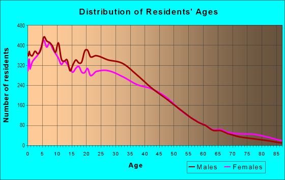
| Males: | 17,395 |
| Females: | 17,312 |
Males:
| This neighborhood: | 33.0 years |
| Whole city: | 32.3 years |
| This neighborhood: | 33.9 years |
| Whole city: | 33.1 years |
Average household size:
| Lynwood Park (Lynwood City Park): | 8.0 people |
| Lynwood: | 4.2 people |
Percentage of family households:
| Lynwood Park (Lynwood City Park): | 63.0% |
| Lynwood: | 64.3% |
| Here: | 51.7% |
| Lynwood: | 43.4% |
Percentage of married-couple families with children (among all households):
| Lynwood Park (Lynwood City Park): | 14.2% |
| Lynwood: | 8.6% |
Percentage of single-mother households (among all households):
| Lynwood Park (Lynwood City Park): | 9.0% |
| Lynwood: | 9.7% |
Percentage of never married males 15 years old and over:
Percentage of never married females 15 years old and over:
| Lynwood Park (Lynwood City Park): | 24.0% |
| Lynwood: | 27.1% |
Percentage of never married females 15 years old and over:
| Lynwood Park (Lynwood City Park): | 24.2% |
| city: | 26.7% |
Percentage of people that speak English not well or not at all:
| Lynwood Park (Lynwood City Park): | 19.9% |
| Lynwood: | 20.1% |
Percentage of people born in this state:
Percentage of people born in another U.S. state:
Percentage of native residents but born outside the U.S.:
Percentage of foreign born residents:
| Here: | 55.5% |
| Lynwood: | 59.6% |
Percentage of people born in another U.S. state:
| Lynwood Park (Lynwood City Park): | 4.8% |
| Lynwood: | 3.0% |
Percentage of native residents but born outside the U.S.:
| Here: | 1.3% |
| city: | 1.5% |
Percentage of foreign born residents:
| Here: | 38.5% |
| Lynwood: | 35.9% |

Owner-occupied
Renter-occupied


- Rooms in owner-occupied houses and condos in Lynwood Park <
> - 4401 room
- 3282 rooms
- 3873 rooms
- 1,0804 rooms
- 1,1885 rooms
- 1,1006 rooms
- 6477 rooms
- 6058 rooms
- 4679+ rooms

- Rooms in renter-occupied apartments in Lynwood Park <
> - 7731 room
- 4652 rooms
- 1,2493 rooms
- 1,5904 rooms
- 7665 rooms
- 5486 rooms
- 7047 rooms
- 2658 rooms
- 2299+ rooms
Owner-occupied
Renter-occupied

- Bedrooms in owner-occupied houses and condos in Lynwood Park <
> - 440no bedroom
- 2601 bedroom
- 1,6892 bedrooms
- 1,8233 bedrooms
- 9024 bedrooms
- 2485+ bedrooms

- Bedrooms in renter-occupied apartments in Lynwood Park <
> - 774no bedroom
- 1,7971 bedroom
- 1,6202 bedrooms
- 8863 bedrooms
- 5274 bedrooms
- 6595+ bedrooms
Average number of cars or other vehicles available in houses/condos:
Average number of cars or other vehicles available in apartments:
| This neighborhood: | 2.6 |
| Lynwood: | 2.8 |
Average number of cars or other vehicles available in apartments:
| Here: | |
| city: |
Percentage of units with a mortgage:
| Lynwood Park (Lynwood City Park): | 71.3% |
| Lynwood: | 73.9% |
Average estimated value of detached houses in 2022 (55.9% of all units):
| Lynwood Park (Lynwood City Park): | $526,894 |
| California: | $988,808 |

- Year house built in Lynwood Park <
> - 2712020 or later
- 3402010 to 2019
- 4902000 to 2009
- 6281990 to 1999
- 9801980 to 1989
- 9401970 to 1979
- 1,3071960 to 1969
- 2,1761950 to 1959
- 2,0501940 to 1949
- 1,4251939 or earlier

City-data.com crime index for city in 2020 (higher means more crime):
| City: | 302.6 |
| U.S. average: | 219.5 |
Travel time to work (commute)
![Travel time to work (commute)]()
- 156Less than 5 minutes
- 7255 to 9 minutes
- 1,12810 to 14 minutes
- 1,53815 to 19 minutes
- 2,03720 to 24 minutes
- 93425 to 29 minutes
- 3,01130 to 34 minutes
- 40835 to 39 minutes
- 1,01040 to 44 minutes
- 1,42845 to 59 minutes
- 1,29260 to 89 minutes
- 43690 or more minutes

Means of transportation to work
![Means of transportation to work]()
- 71.9%10,528Drove a car alone
- 15.8%2,312Carpooled
- 7.0%1,024Bus
- 5.2%759Subway or elevated rail
- 1.5%221Long-distance train or commuter rail
- 7.3%1,061Light rail, streetcar or trolley
- 3.9%576Taxi
- 3.4%502Motorcycle
- 13.3%1,944Bicycle
- 5.5%811Walked
- 4.1%598Other means
- 4.6%667Worked at home

Time leaving home to go to work
![Time leaving home to go to work]()
- 1,51012:00 a.m. to 4:59 a.m.
- 1,2255:00 a.m. to 5:29 a.m.
- 9665:30 a.m. to 5:59 a.m.
- 1,5166:00 a.m. to 6:29 a.m.
- 1,0056:30 a.m. to 6:59 a.m.
- 1,6307:00 a.m. to 7:29 a.m.
- 9877:30 a.m. to 7:59 a.m.
- 1,1988:00 a.m. to 8:29 a.m.
- 4348:30 a.m. to 8:59 a.m.
- 5289:00 a.m. to 9:59 a.m.
- 44710:00 a.m. to 10:59 a.m.
- 21911:00 a.m. to 11:59 a.m.
- 1,34812:00 p.m. to 3:59 p.m.
- 9454:00 p.m. to 11:59 p.m.

Occupations of males:
- Percentage of males in management occupations (except farmers):
Here: 5.2% city: 3.9%
- Percentage of males in business and financial operations occupations:
Here: 1.2% city: 0.8%
- Percentage of males in education, training, and library occupations:
Here: 1.7% city: 2.3%
- Percentage of males in service occupations:
Here: 15.4% city: 17.7%
- Percentage of males in sales and office occupations:
Here: 17.5% city: 14.5%
- Percentage of males in construction, extraction, and maintenance occupations:
Here: 12.3% city: 14.0%
- Percentage of males in production occupations:
Here: 14.8% city: 13.4%
- Percentage of males in transportation occupations:
Here: 10.3% city: 11.5%
- Percentage of males in material moving occupations:
Here: 10.7% city: 11.2%
Occupations of females:
- Percentage of females in management occupations (except farmers):
Here: 6.9% city: 5.5%
- Percentage of females in business and financial operations occupations:
Here: 4.6% city: 3.9%
- Percentage of females in community and social services occupations:
Here: 1.1% city: 1.6%
- Percentage of females in education, training, and library occupations:
Here: 5.9% city: 5.8%
- Percentage of females in healthcare practitioners and technical occupations:
Here: 5.4% city: 4.1%
- Percentage of females in service occupations:
Here: 24.7% city: 28.8%
- Percentage of females in sales and office occupations:
Here: 31.5% city: 30.3%
- Percentage of females in production occupations:
Here: 10.6% city: 8.7%
- Percentage of females in transportation occupations:
Here: 1.7% city: 1.5%
- Percentage of females in material moving occupations:
Here: 4.3% city: 6.4%
Percentage of people 16-64 in Armed Forces:
| Lynwood Park (Lynwood City Park): | 0.1% |
| Lynwood: | 0.0% |
Education in this neighborhood (subdivision or community):
- Percentage of people 3 years and older in K-12 schools:
Lynwood Park (Lynwood City Park): 25.4% Lynwood: 19.9%
- Percentage of people 3 years and older in undergraduate colleges:
Lynwood Park (Lynwood City Park): 7.5% Lynwood: 5.8%
- Percentage of people 3 years and older in grad. or professional schools:
Lynwood Park (Lynwood City Park): 2.7% Lynwood: 0.8%
- Percentage of students K-12 enrolled in private schools:
Lynwood Park (Lynwood City Park): 51.2% Lynwood: 2.6%
Percentage of population below poverty level:
| Lynwood Park (Lynwood City Park): | 15.0% |
| Lynwood: | 19.3% |
Percentage of married-couple families with both working:
| Lynwood Park (Lynwood City Park): | 76.4% |
| Lynwood: | 53.4% |

- 52.8%Utility gas
- 20.7%Electricity
- 10.2%No fuel used
- 6.5%Wood
- 4.2%Other fuel
- 3.3%Bottled, tank, or LP gas
- 2.2%Solar energy
Limited-access highways (interstate or state) in this neighborhood:
Century Fwy (Glenn M Anderson Freeway and Transit, I- 105, Glenn M Anderson Freeway and Transit, Interstate Highway 105, Century Freeway)
Length: 5.36 miles
Directions: E-W, SE-NW
Directions: E-W, SE-NW
Highways in this neighborhood:
State Rte 90 (Imperial Hwy)
Length: 3.14 miles
Directions: E-W, SE-NW, SW-NE
Address range: 2600 to 5039
Directions: E-W, SE-NW, SW-NE
Address range: 2600 to 5039
Roads and streets:
Martin Luther King Jr Blvd (Century Blvd)
Length: 3.11 miles
Directions: E-W, N-S, SE-NW, SW-NE
Address range: 2600 to 5115
Directions: E-W, N-S, SE-NW, SW-NE
Address range: 2600 to 5115
Fernwood Ave
Length: 2.54 miles
Directions: E-W, SE-NW, SW-NE
Address range: 2500 to 5117
Directions: E-W, SE-NW, SW-NE
Address range: 2500 to 5117
Atlantic Ave (S Atlantic Ave)
Length: 2.24 miles
Directions: N-S, SW-NE
Address range: 11000 to 11799
Directions: N-S, SW-NE
Address range: 11000 to 11799
Los Flores Blvd
Length: 1.87 miles
Directions: E-W, SE-NW
Address range: 2800 to 5127
Directions: E-W, SE-NW
Address range: 2800 to 5127
Norton Ave
Length: 1.72 miles
Direction: E-W
Address range: 2600 to 3699
Direction: E-W
Address range: 2600 to 3699
Beechwood Ave
Length: 1.47 miles
Directions: E-W, SW-NE
Address range: 2900 to 5114
Directions: E-W, SW-NE
Address range: 2900 to 5114
Platt Ave
Length: 1.44 miles
Directions: E-W, SW-NE
Address range: 3300 to 4299
Directions: E-W, SW-NE
Address range: 3300 to 4299
Walnut Ave
Length: 1.33 miles
Direction: E-W
Address range: 3600 to 5113
Direction: E-W
Address range: 3600 to 5113
S Alameda St
Length: 1.22 miles
Directions: N-S, SE-NW
Address range: 10677 to 11799
Directions: N-S, SE-NW
Address range: 10677 to 11799
Long Beach Blvd
Length: 1.11 miles
Directions: N-S, SE-NW
Address range: 10600 to 11699
Directions: N-S, SE-NW
Address range: 10600 to 11699
Lugo Ave
Length: 1.10 miles
Direction: E-W
Address range: 3600 to 4399
Direction: E-W
Address range: 3600 to 4399
Harris Ave
Length: 1.01 miles
Directions: N-S, SW-NE
Address range: 11000 to 11799
Directions: N-S, SW-NE
Address range: 11000 to 11799
Cortland St
Length: 0.97 miles
Direction: E-W
Address range: 3800 to 5113
Direction: E-W
Address range: 3800 to 5113
Elm Ave
Length: 0.94 miles
Directions: N-S, SW-NE
Address range: 11000 to 11699
Directions: N-S, SW-NE
Address range: 11000 to 11699
Sanborn Ave
Length: 0.91 miles
Directions: E-W, SE-NW
Address range: 3100 to 5114
Directions: E-W, SE-NW
Address range: 3100 to 5114
Bullis Rd
Length: 0.87 miles
Directions: N-S, SW-NE
Address range: 11000 to 11699
Directions: N-S, SW-NE
Address range: 11000 to 11699
Le Sage St
Length: 0.85 miles
Directions: E-W, SE-NW
Address range: 3600 to 4099
Directions: E-W, SE-NW
Address range: 3600 to 4099
State St
Length: 0.82 miles
Directions: N-S, SE-NW, SW-NE
Address range: 10600 to 11399
Directions: N-S, SE-NW, SW-NE
Address range: 10600 to 11399
Shirley Ave
Length: 0.80 miles
Directions: E-W, SE-NW
Address range: 3800 to 4399
Directions: E-W, SE-NW
Address range: 3800 to 4399
Louise St
Length: 0.80 miles
Directions: E-W, N-S, SE-NW
Address range: 3500 to 4199
Directions: E-W, N-S, SE-NW
Address range: 3500 to 4199
Linden St
Length: 0.77 miles
Directions: N-S, SW-NE
Address range: 11000 to 11499
Directions: N-S, SW-NE
Address range: 11000 to 11499
California Ave
Length: 0.76 miles
Directions: E-W, N-S, SE-NW
Address range: 10618 to 11499
Directions: E-W, N-S, SE-NW
Address range: 10618 to 11499
Josephine St
Length: 0.67 miles
Directions: E-W, SE-NW
Address range: 4000 to 5103
Directions: E-W, SE-NW
Address range: 4000 to 5103
Lynwood Rd
Length: 0.65 miles
Directions: E-W, SE-NW
Address range: 3280 to 3799
Directions: E-W, SE-NW
Address range: 3280 to 3799
Ernestine Ave
Length: 0.65 miles
Directions: N-S, SW-NE
Address range: 11200 to 11699
Directions: N-S, SW-NE
Address range: 11200 to 11699
Muriel Dr
Length: 0.59 miles
Directions: N-S, SE-NW, SW-NE
Address range: 11200 to 11784
Directions: N-S, SE-NW, SW-NE
Address range: 11200 to 11784
Gertrude Dr
Length: 0.58 miles
Directions: N-S, SW-NE
Address range: 11300 to 11799
Directions: N-S, SW-NE
Address range: 11300 to 11799
Pine Ave
Length: 0.58 miles
Directions: N-S, SW-NE
Address range: 11000 to 11399
Directions: N-S, SW-NE
Address range: 11000 to 11399
Oakwood Ave
Length: 0.55 miles
Direction: E-W
Address range: 2900 to 3299
Direction: E-W
Address range: 2900 to 3299
Hulme Ave
Length: 0.55 miles
Directions: N-S, SE-NW, SW-NE
Address range: 11000 to 11399
Directions: N-S, SE-NW, SW-NE
Address range: 11000 to 11399
Poplar Dr
Length: 0.51 miles
Direction: E-W
Address range: 2900 to 3299
Direction: E-W
Address range: 2900 to 3299
Santa Fe Ave
Length: 0.51 miles
Directions: N-S, SE-NW, SW-NE
Address range: 10700 to 11653
Directions: N-S, SE-NW, SW-NE
Address range: 10700 to 11653
Peach St
Length: 0.50 miles
Directions: N-S, SE-NW, SW-NE
Address range: 11000 to 11507
Directions: N-S, SE-NW, SW-NE
Address range: 11000 to 11507
Birch St
Length: 0.47 miles
Directions: N-S, SW-NE
Address range: 11100 to 11499
Directions: N-S, SW-NE
Address range: 11100 to 11499
Tecumseh Ave
Length: 0.46 miles
Direction: E-W
Address range: 3100 to 3386
Direction: E-W
Address range: 3100 to 3386
Mulford Ave
Length: 0.46 miles
Directions: E-W, N-S, SE-NW
Address range: 3200 to 3599
Directions: E-W, N-S, SE-NW
Address range: 3200 to 3599
Woodlawn Ave
Length: 0.44 miles
Directions: E-W, SE-NW
Address range: 3800 to 4099
Directions: E-W, SE-NW
Address range: 3800 to 4099
Spruce St
Length: 0.43 miles
Directions: E-W, N-S, SE-NW, SW-NE
Address range: 11300 to 11498
Directions: E-W, N-S, SE-NW, SW-NE
Address range: 11300 to 11498
Abbott Rd
Length: 0.41 miles
Direction: E-W
Address range: 3600 to 4070
Direction: E-W
Address range: 3600 to 4070
Lorrain St
Length: 0.41 miles
Directions: N-S, SW-NE
Address range: 10700 to 11299
Directions: N-S, SW-NE
Address range: 10700 to 11299
Lilita St
Length: 0.37 miles
Directions: E-W, SW-NE
Address range: 3600 to 3899
Directions: E-W, SW-NE
Address range: 3600 to 3899
Brewster Ave
Length: 0.36 miles
Directions: E-W, SE-NW
Address range: 4200 to 4399
Directions: E-W, SE-NW
Address range: 4200 to 4399
Elizabeth Ave
Length: 0.36 miles
Directions: E-W, N-S
Address range: 3300 to 10699
Directions: E-W, N-S
Address range: 3300 to 10699
Alma Ave
Length: 0.32 miles
Direction: E-W
Address range: 3300 to 3499
Direction: E-W
Address range: 3300 to 3499
Elmwood Ave
Length: 0.32 miles
Direction: E-W
Address range: 4200 to 5113
Direction: E-W
Address range: 4200 to 5113
San Jose Ave
Length: 0.31 miles
Direction: N-S
Address range: 10600 to 10899
Direction: N-S
Address range: 10600 to 10899
Lyndora St
Length: 0.30 miles
Direction: E-W
Address range: 3800 to 3999
Direction: E-W
Address range: 3800 to 3999
Flower St
Length: 0.30 miles
Directions: E-W, SE-NW
Address range: 3156 to 3399
Directions: E-W, SE-NW
Address range: 3156 to 3399
Thorson Ave
Length: 0.29 miles
Directions: N-S, SW-NE
Address range: 11200 to 11799
Directions: N-S, SW-NE
Address range: 11200 to 11799
E 109th St
Length: 0.29 miles
Direction: E-W
Address range: 2570 to 2799
Direction: E-W
Address range: 2570 to 2799
Brenton Ave
Length: 0.28 miles
Directions: E-W, N-S, SE-NW, SW-NE
Address range: 3500 to 3599
Directions: E-W, N-S, SE-NW, SW-NE
Address range: 3500 to 3599
E 110th St
Length: 0.28 miles
Direction: E-W
Address range: 2570 to 2799
Direction: E-W
Address range: 2570 to 2799
Capistrano Ave
Length: 0.28 miles
Directions: N-S, SW-NE
Address range: 10654 to 10899
Directions: N-S, SW-NE
Address range: 10654 to 10899
Carson Dr
Length: 0.27 miles
Directions: N-S, SW-NE
Address range: 11000 to 11199
Directions: N-S, SW-NE
Address range: 11000 to 11199
E 111th St
Length: 0.27 miles
Direction: E-W
Address range: 2570 to 2799
Direction: E-W
Address range: 2570 to 2799
San Luis Ave
Length: 0.27 miles
Directions: N-S, SW-NE
Address range: 10630 to 10999
Directions: N-S, SW-NE
Address range: 10630 to 10999
Cesar E Chavez Ln
Length: 0.27 miles
Directions: E-W, SE-NW, SW-NE
Directions: E-W, SE-NW, SW-NE
San Miguel Ave
Length: 0.27 miles
Direction: N-S
Address range: 10644 to 10999
Direction: N-S
Address range: 10644 to 10999
Drury Ln
Length: 0.25 miles
Direction: N-S
Address range: 10700 to 10899
Direction: N-S
Address range: 10700 to 10899
Osgood Ave
Length: 0.25 miles
Direction: N-S
Address range: 10700 to 10899
Direction: N-S
Address range: 10700 to 10899
Barlow Ave
Length: 0.24 miles
Direction: N-S
Address range: 10700 to 10899
Direction: N-S
Address range: 10700 to 10899
E 108th St
Length: 0.24 miles
Direction: E-W
Address range: 2600 to 2799
Direction: E-W
Address range: 2600 to 2799
Cornish Ave
Length: 0.24 miles
Directions: N-S, SW-NE
Address range: 11200 to 11399
Directions: N-S, SW-NE
Address range: 11200 to 11399
Benwell Dr
Length: 0.24 miles
Directions: N-S, SW-NE
Address range: 11000 to 11199
Directions: N-S, SW-NE
Address range: 11000 to 11199
San Vincente Ave
Length: 0.23 miles
Direction: N-S
Address range: 10700 to 10999
Direction: N-S
Address range: 10700 to 10999
Bellinger St
Length: 0.23 miles
Directions: N-S, SE-NW
Address range: 11000 to 11199
Directions: N-S, SE-NW
Address range: 11000 to 11199
Stanford Ave
Length: 0.22 miles
Directions: E-W, N-S, SW-NE
Address range: 10651 to 10999
Directions: E-W, N-S, SW-NE
Address range: 10651 to 10999
Fir St
Length: 0.22 miles
Directions: N-S, SW-NE
Address range: 11400 to 11599
Directions: N-S, SW-NE
Address range: 11400 to 11599
Sampson Ave
Length: 0.18 miles
Directions: N-S, SW-NE
Address range: 11200 to 11299
Directions: N-S, SW-NE
Address range: 11200 to 11299
Sue Ave
Length: 0.18 miles
Directions: N-S, SW-NE
Address range: 11000 to 11299
Directions: N-S, SW-NE
Address range: 11000 to 11299
Stockwell Dr
Length: 0.18 miles
Directions: N-S, SW-NE
Address range: 11000 to 11199
Directions: N-S, SW-NE
Address range: 11000 to 11199
E 112th St
Length: 0.18 miles
Direction: E-W
Address range: 2600 to 2799
Direction: E-W
Address range: 2600 to 2799
Colyer Ave
Length: 0.16 miles
Directions: N-S, SW-NE
Address range: 11200 to 11299
Directions: N-S, SW-NE
Address range: 11200 to 11299
Adley Ave
Length: 0.16 miles
Directions: E-W, SE-NW, SW-NE
Address range: 11000 to 11099
Directions: E-W, SE-NW, SW-NE
Address range: 11000 to 11099
Franklin St
Length: 0.15 miles
Directions: N-S, SW-NE
Address range: 11100 to 11299
Directions: N-S, SW-NE
Address range: 11100 to 11299
Pluma St
Length: 0.14 miles
Direction: E-W
Address range: 3100 to 3199
Direction: E-W
Address range: 3100 to 3199
Alberta St
Length: 0.14 miles
Directions: E-W, SE-NW
Address range: 4000 to 4099
Directions: E-W, SE-NW
Address range: 4000 to 4099
Harriet Tubman Way
Length: 0.14 miles
Direction: E-W
Direction: E-W
Redwood
Length: 0.13 miles
Directions: E-W, N-S
Address range: 11654 to 11699
Directions: E-W, N-S
Address range: 11654 to 11699
Penn St
Length: 0.13 miles
Directions: N-S, SW-NE
Address range: 11100 to 11299
Directions: N-S, SW-NE
Address range: 11100 to 11299
Apricot St
Length: 0.13 miles
Directions: E-W, N-S, SW-NE
Address range: 11200 to 11399
Directions: E-W, N-S, SW-NE
Address range: 11200 to 11399
1st Ave
Length: 0.11 miles
Direction: N-S
Address range: 11600 to 11799
Direction: N-S
Address range: 11600 to 11799
Chester St
Length: 0.11 miles
Direction: SW-NE
Address range: 11200 to 11399
Direction: SW-NE
Address range: 11200 to 11399
Court St
Length: 0.10 miles
Directions: N-S, SW-NE
Address range: 11300 to 11399
Directions: N-S, SW-NE
Address range: 11300 to 11399
Copeland St
Length: 0.10 miles
Directions: N-S, SW-NE
Address range: 11400 to 11499
Directions: N-S, SW-NE
Address range: 11400 to 11499
Arval St
Length: 0.09 miles
Directions: SE-NW, SW-NE
Address range: 11000 to 11099
Directions: SE-NW, SW-NE
Address range: 11000 to 11099
Jackson Ave
Length: 0.08 miles
Directions: N-S, SW-NE
Address range: 11200 to 11299
Directions: N-S, SW-NE
Address range: 11200 to 11299
Plaza St
Length: 0.08 miles
Directions: N-S, SE-NW
Address range: 11300 to 11399
Directions: N-S, SE-NW
Address range: 11300 to 11399
Ira St
Length: 0.07 miles
Directions: E-W, N-S, SE-NW
Address range: 3900 to 3999
Directions: E-W, N-S, SE-NW
Address range: 3900 to 3999
Grant St
Length: 0.07 miles
Directions: N-S, SW-NE
Address range: 11100 to 11199
Directions: N-S, SW-NE
Address range: 11100 to 11199
Lewis St
Length: 0.07 miles
Direction: N-S
Address range: 11500 to 11699
Direction: N-S
Address range: 11500 to 11699
Mariposa Ln
Length: 0.07 miles
Direction: N-S
Address range: 10600 to 10699
Direction: N-S
Address range: 10600 to 10699
Grape St
Length: 0.07 miles
Direction: N-S
Address range: 11200 to 11299
Direction: N-S
Address range: 11200 to 11299
Eve Ave
Length: 0.07 miles
Direction: N-S
Address range: 11000 to 11099
Direction: N-S
Address range: 11000 to 11099
Annetta Ave
Length: 0.06 miles
Directions: N-S, SW-NE
Address range: 11300 to 11399
Directions: N-S, SW-NE
Address range: 11300 to 11399
4th Ave
Length: 0.05 miles
Direction: N-S
Address range: 11718 to 11799
Direction: N-S
Address range: 11718 to 11799
Warren Ave
Length: 0.04 miles
Direction: SW-NE
Address range: 11600 to 11699
Direction: SW-NE
Address range: 11600 to 11699
3rd Ave
Length: 0.04 miles
Direction: SW-NE
Address range: 11716 to 11799
Direction: SW-NE
Address range: 11716 to 11799
Olive St
Length: 0.04 miles
Direction: N-S
Address range: 11600 to 11699
Direction: N-S
Address range: 11600 to 11699
School St
Length: 0.04 miles
Direction: N-S
Address range: 11600 to 11699
Direction: N-S
Address range: 11600 to 11699
San Gabriel Ave
Length: 0.04 miles
Direction: N-S
Address range: 10616 to 10699
Direction: N-S
Address range: 10616 to 10699
2nd Ave
Length: 0.04 miles
Directions: N-S, SW-NE
Address range: 11720 to 11799
Directions: N-S, SW-NE
Address range: 11720 to 11799
Ruth Ave
Length: 0.04 miles
Direction: N-S
Address range: 10968 to 10999
Direction: N-S
Address range: 10968 to 10999
San Juan Ave
Length: 0.04 miles
Direction: N-S
Address range: 10604 to 10699
Direction: N-S
Address range: 10604 to 10699
Otis St
Length: 0.03 miles
Direction: N-S
Address range: 10970 to 10999
Direction: N-S
Address range: 10970 to 10999
Virginia Ave
Length: 0.03 miles
Direction: N-S
Address range: 10628 to 10699
Direction: N-S
Address range: 10628 to 10699
San Antonio Ave
Length: 0.03 miles
Direction: N-S
Address range: 10628 to 10699
Direction: N-S
Address range: 10628 to 10699
E 114th St
Length: 0.03 miles
Direction: E-W
Address range: 2578 to 2599
Direction: E-W
Address range: 2578 to 2599
Lewis Rd
Length: 0.03 miles
Direction: N-S
Address range: 10958 to 10999
Direction: N-S
Address range: 10958 to 10999
San Carlos Ave
Length: 0.03 miles
Direction: N-S
Address range: 10624 to 10699
Direction: N-S
Address range: 10624 to 10699
Alamo Ct
Length: 0.03 miles
Directions: E-W, N-S, SW-NE
Address range: 11100 to 11299
Directions: E-W, N-S, SW-NE
Address range: 11100 to 11299
Mc Nerney Ave
Length: 0.03 miles
Direction: N-S
Address range: 10960 to 10999
Direction: N-S
Address range: 10960 to 10999
Fracar Ave
Length: 0.03 miles
Direction: N-S
Address range: 10960 to 10999
Direction: N-S
Address range: 10960 to 10999
Alexander Ave
Length: 0.03 miles
Direction: N-S
Address range: 10960 to 10999
Direction: N-S
Address range: 10960 to 10999
Dolores Ave
Length: 0.03 miles
Direction: N-S
Address range: 10654 to 10699
Direction: N-S
Address range: 10654 to 10699
Montara Ave
Length: 0.03 miles
Direction: N-S
Address range: 10656 to 10699
Direction: N-S
Address range: 10656 to 10699
San Anselmo Ave
Length: 0.03 miles
Direction: N-S
Address range: 10656 to 10699
Direction: N-S
Address range: 10656 to 10699
Pescadero Ave
Length: 0.03 miles
Direction: N-S
Address range: 10656 to 10699
Direction: N-S
Address range: 10656 to 10699
Railroad features:
Southern Pacific RR
Length: 0.64 miles
Directions: E-W, N-S
Directions: E-W, N-S