Tappan neighborhood in Ravenna, Ohio (OH), 44266 detailed profile
Settings
X


Business Search - 14 Million verified businesses
Area: 2.954 square miles
Population: 5,519
Population density:
| Tappan: | 1,868 people per square mile |
| Ravenna: | 2,116 people per square mile |

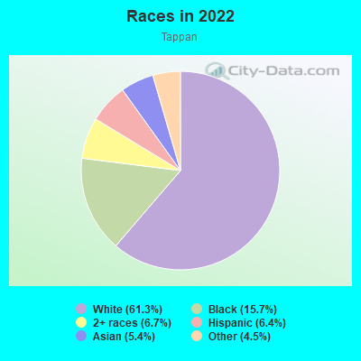
- 4,03561.3%White
- 1,03515.7%Black
- 4426.7%Two or more races
- 4236.4%Hispanic or Latino
- 3535.4%Asian
- 2944.5%Some other race
Distribution of median household income
![Distribution of median household income]()
- 350Less than $10,000
- 624$10,000 to $19,999
- 435$20,000 to $29,999
- 284$30,000 to $39,999
- 262$40,000 to $49,999
- 175$50,000 to $59,999
- 346$60,000 to $74,999
- 314$75,000 to $99,999
- 185$100,000 to $124,999
- 82$125,000 to $149,999
- 117$150,000 to $199,999
- 102$200,000 or more

Distribution of owner-occupied house/condo value
![Distribution of owner-occupied house/condo value]()
- 411Less than $50,000
- 609$50,000 to $99,999
- 599$100,000 to $149,999
- 325$150,000 to $199,999
- 134$200,000 to $249,999
- 84$250,000 to $299,999
- 140$300,000 to $399,999
- 18$400,000 to $499,999
- 52$500,000 to $749,999
- 5$750,000 to $999,999
- 132$1,000,000 or more

Distribution of rent paid by renters
![Distribution of rent paid by renters]()
- 31Less than $100
- 106$200 to $299
- 411$300 to $399
- 287$400 to $499
- 331$500 to $599
- 373$600 to $699
- 566$700 to $799
- 184$800 to $899
- 51$900 to $999
- 337$1,000 to $1,249
- 116$1,250 to $1,499
- 11$1,500 to $1,999
- 182$2,000 or more

Median rent in 2022:
| Tappan: | $814 |
| Ravenna: | $728 |
| Males: | 2,662 |
| Females: | 2,857 |
Males:
| This neighborhood: | 40.9 years |
| Whole city: | 39.1 years |
| This neighborhood: | 41.4 years |
| Whole city: | 43.2 years |
Average household size:
| Tappan: | 2.3 people |
| Ravenna: | 2.2 people |
Percentage of family households:
| Tappan: | 45.7% |
| Ravenna: | 41.7% |
| Here: | 36.9% |
| Ravenna: | 35.3% |
Percentage of married-couple families with children (among all households):
| Tappan: | 16.0% |
| Ravenna: | 23.3% |
Percentage of single-mother households (among all households):
| Tappan: | 43.1% |
| Ravenna: | 17.2% |
Percentage of never married males 15 years old and over:
Percentage of never married females 15 years old and over:
| Tappan: | 17.6% |
| Ravenna: | 18.2% |
Percentage of never married females 15 years old and over:
| Tappan: | 14.6% |
| city: | 15.6% |
Percentage of people that speak English not well or not at all:
| Tappan: | 1.9% |
| Ravenna: | 1.3% |
Percentage of people born in this state:
Percentage of people born in another U.S. state:
Percentage of native residents but born outside the U.S.:
Percentage of foreign born residents:
| Here: | 77.7% |
| Ravenna: | 79.8% |
Percentage of people born in another U.S. state:
| Tappan: | 16.7% |
| Ravenna: | 16.9% |
Percentage of native residents but born outside the U.S.:
| Here: | 1.2% |
| city: | 0.7% |
Percentage of foreign born residents:
| Here: | 5.2% |
| Ravenna: | 2.5% |

Owner-occupied
Renter-occupied


- Rooms in owner-occupied houses and condos in Tappan
- 01 room
- 02 rooms
- 333 rooms
- 1054 rooms
- 2665 rooms
- 3786 rooms
- 2457 rooms
- 2258 rooms
- 2269+ rooms

- Rooms in renter-occupied apartments in Tappan
- 871 room
- 1972 rooms
- 4803 rooms
- 4024 rooms
- 3515 rooms
- 2026 rooms
- 737 rooms
- 308 rooms
- 479+ rooms
Owner-occupied
Renter-occupied

- Bedrooms in owner-occupied houses and condos in Tappan
- 0no bedroom
- 51 bedroom
- 3402 bedrooms
- 6923 bedrooms
- 3404 bedrooms
- 895+ bedrooms

- Bedrooms in renter-occupied apartments in Tappan
- 87no bedroom
- 3061 bedroom
- 6062 bedrooms
- 2853 bedrooms
- 684 bedrooms
- 05+ bedrooms
Average number of cars or other vehicles available in houses/condos:
Average number of cars or other vehicles available in apartments:
| This neighborhood: | 2.0 |
| Ravenna: | 2.1 |
Average number of cars or other vehicles available in apartments:
| Here: | 0.9 |
| city: | 1.0 |
Percentage of units with a mortgage:
| Tappan: | 66.5% |
| Ravenna: | 70.6% |
Average estimated value of detached houses in 2022 (56.0% of all units):
| Tappan: | $146,144 |
| Ohio: | $254,366 |

- Year house built in Tappan
- 2312020 or later
- 3232010 to 2019
- 1562000 to 2009
- 1151990 to 1999
- 2051980 to 1989
- 3381970 to 1979
- 4221960 to 1969
- 2561950 to 1959
- 3301940 to 1949
- 9341939 or earlier

Travel time to work (commute)
![Travel time to work (commute)]()
- 99Less than 5 minutes
- 3825 to 9 minutes
- 20710 to 14 minutes
- 37715 to 19 minutes
- 33520 to 24 minutes
- 18325 to 29 minutes
- 26330 to 34 minutes
- 9735 to 39 minutes
- 10840 to 44 minutes
- 24645 to 59 minutes
- 6760 to 89 minutes
- 3190 or more minutes

Means of transportation to work
![Means of transportation to work]()
- 83.6%1,939Drove a car alone
- 11.9%275Carpooled
- 0.0%1Bus
- 2.9%67Walked
- 3.5%81Other means
- 4.1%94Worked at home

Time leaving home to go to work
![Time leaving home to go to work]()
- 14812:00 a.m. to 4:59 a.m.
- 1105:00 a.m. to 5:29 a.m.
- 1045:30 a.m. to 5:59 a.m.
- 2376:00 a.m. to 6:29 a.m.
- 3106:30 a.m. to 6:59 a.m.
- 3427:00 a.m. to 7:29 a.m.
- 2047:30 a.m. to 7:59 a.m.
- 1738:00 a.m. to 8:29 a.m.
- 1608:30 a.m. to 8:59 a.m.
- 1489:00 a.m. to 9:59 a.m.
- 8710:00 a.m. to 10:59 a.m.
- 3211:00 a.m. to 11:59 a.m.
- 16812:00 p.m. to 3:59 p.m.
- 1304:00 p.m. to 11:59 p.m.

Occupations of males:
- Percentage of males in management occupations (except farmers):
Here: 3.1% city: 7.9%
- Percentage of males in business and financial operations occupations:
Here: 1.7% city: 1.8%
- Percentage of males in computer and mathematical occupations:
Here: 1.4% city: 1.7%
- Percentage of males in architecture and engineering occupations:
Here: 2.9% city: 3.1%
- Percentage of males in education, training, and library occupations:
Here: 4.7% city: 4.7%
- Percentage of males in service occupations:
Here: 20.1% city: 17.8%
- Percentage of males in sales and office occupations:
Here: 10.9% city: 8.6%
- Percentage of males in construction, extraction, and maintenance occupations:
Here: 7.9% city: 9.4%
- Percentage of males in production occupations:
Here: 20.1% city: 17.8%
- Percentage of males in transportation occupations:
Here: 7.3% city: 9.0%
- Percentage of males in material moving occupations:
Here: 8.8% city: 7.0%
Occupations of females:
- Percentage of females in management occupations (except farmers):
Here: 10.9% city: 8.4%
- Percentage of females in business and financial operations occupations:
Here: 2.4% city: 3.4%
- Percentage of females in computer and mathematical occupations:
Here: 1.7% city: 1.2%
- Percentage of females in community and social services occupations:
Here: 1.4% city: 2.9%
- Percentage of females in education, training, and library occupations:
Here: 5.3% city: 9.5%
- Percentage of females in healthcare practitioners and technical occupations:
Here: 10.3% city: 12.6%
- Percentage of females in service occupations:
Here: 27.4% city: 25.9%
- Percentage of females in sales and office occupations:
Here: 30.0% city: 26.8%
- Percentage of females in construction, extraction, and maintenance occupations:
Here: 2.4% city: 1.1%
- Percentage of females in production occupations:
Here: 4.9% city: 5.3%
- Percentage of females in transportation occupations:
Here: 1.4% city: 0.2%
Percentage of people 16-64 in Armed Forces:
| Tappan: | 0.0% |
| Ravenna: | 0.0% |
Education in this neighborhood (subdivision or community):
- Percentage of people 3 years and older in K-12 schools:
Tappan: 31.0% Ravenna: 15.2%
- Percentage of people 3 years and older in undergraduate colleges:
Tappan: 6.2% Ravenna: 4.7%
- Percentage of people 3 years and older in grad. or professional schools:
Tappan: 2.0% Ravenna: 0.5%
- Percentage of students K-12 enrolled in private schools:
Tappan: 10.0% Ravenna: 4.0%
Percentage of population below poverty level:
| Tappan: | 16.6% |
| Ravenna: | 19.8% |
Median year owner moved in (as recorded in 2022):
Median year renter moved in (as recorded in 2022):
| Tappan: | 2006 |
| Ravenna: | 2006 |
Median year renter moved in (as recorded in 2022):
| Tappan: | 2016 |
| Ravenna: | 2016 |
Percentage of married-couple families with both working:
| Tappan: | 102.0% |
| Ravenna: | 71.5% |

- 57.0%Utility gas
- 22.5%Electricity
- 7.7%Fuel oil, kerosene, etc.
- 5.3%Bottled, tank, or LP gas
- 4.0%Other fuel
- 1.6%Wood
- 1.4%No fuel used
- 0.6%Coal or coke
Highways in this neighborhood:
State Rte 59 (Ravenna Warren Rd)
Length: 1.88 miles
Direction: E-W
Address range: 100 to 4915
Direction: E-W
Address range: 100 to 4915
State Rte 5 Byp (State Rte 44, State Rte 5)
Length: 1.71 miles
Directions: E-W, N-S, SW-NE
Directions: E-W, N-S, SW-NE
Kent Ravenna Rd (State Rte 59, W Main St)
Length: 0.57 miles
Direction: E-W
Address range: 200 to 619
Direction: E-W
Address range: 200 to 619
State Rte 14 (Cleve E Liverpool Rd)
Length: 0.56 miles
Direction: SE-NW
Address range: 6000 to 6163
Direction: SE-NW
Address range: 6000 to 6163
N Freedom St (State Rte 88)
Length: 0.09 miles
Direction: N-S
Address range: 100 to 139
Direction: N-S
Address range: 100 to 139
Roads and streets:
E Lake St
Length: 1.72 miles
Direction: E-W
Address range: 1 to 910
Direction: E-W
Address range: 1 to 910
Co Hwy 74 (S Prospect St)
Length: 1.62 miles
Directions: N-S, SW-NE
Address range: 200 to 5799
Directions: N-S, SW-NE
Address range: 200 to 5799
E Riddle Ave
Length: 1.32 miles
Direction: E-W
Address range: 100 to 1169
Direction: E-W
Address range: 100 to 1169
E Spruce Ave
Length: 1.00 miles
Direction: E-W
Address range: 100 to 999
Direction: E-W
Address range: 100 to 999
New Milford Rd
Length: 0.86 miles
Directions: E-W, N-S, SE-NW
Address range: 201 to 6999
Directions: E-W, N-S, SE-NW
Address range: 201 to 6999
Summit Rd (Co Hwy 148)
Length: 0.86 miles
Direction: E-W
Address range: 600 to 4199
Direction: E-W
Address range: 600 to 4199
Murray Ave
Length: 0.84 miles
Direction: E-W
Address range: 500 to 1179
Direction: E-W
Address range: 500 to 1179
E Maple Ln
Length: 0.78 miles
Direction: E-W
Address range: 1 to 699
Direction: E-W
Address range: 1 to 699
S Chestnut St
Length: 0.66 miles
Direction: N-S
Address range: 200 to 699
Direction: N-S
Address range: 200 to 699
W Spruce Ave
Length: 0.66 miles
Direction: E-W
Address range: 200 to 737
Direction: E-W
Address range: 200 to 737
E Cedar Ave
Length: 0.65 miles
Direction: E-W
Address range: 2 to 758
Direction: E-W
Address range: 2 to 758
Hazen Ave
Length: 0.64 miles
Direction: E-W
Address range: 200 to 658
Direction: E-W
Address range: 200 to 658
S Walnut St
Length: 0.58 miles
Directions: N-S, SW-NE
Address range: 200 to 699
Directions: N-S, SW-NE
Address range: 200 to 699
W Lake St
Length: 0.57 miles
Direction: E-W
Address range: 205 to 569
Direction: E-W
Address range: 205 to 569
King St
Length: 0.52 miles
Direction: N-S
Address range: 200 to 646
Direction: N-S
Address range: 200 to 646
S Meridian St
Length: 0.51 miles
Direction: N-S
Address range: 200 to 651
Direction: N-S
Address range: 200 to 651
Pratt St
Length: 0.50 miles
Direction: N-S
Address range: 200 to 699
Direction: N-S
Address range: 200 to 699
Ravenna Ave
Length: 0.49 miles
Direction: E-W
Address range: 192 to 551
Direction: E-W
Address range: 192 to 551
Liberty St
Length: 0.48 miles
Direction: N-S
Address range: 200 to 499
Direction: N-S
Address range: 200 to 499
Twp Hwy 556 (S Freedom St)
Length: 0.47 miles
Directions: N-S, SW-NE
Address range: 200 to 5599
Directions: N-S, SW-NE
Address range: 200 to 5599
Ohio Ave
Length: 0.46 miles
Direction: E-W
Address range: 300 to 857
Direction: E-W
Address range: 300 to 857
S Sycamore St
Length: 0.45 miles
Directions: E-W, N-S, SE-NW
Address range: 200 to 619
Directions: E-W, N-S, SE-NW
Address range: 200 to 619
W Riddle Ave
Length: 0.45 miles
Direction: E-W
Address range: 200 to 633
Direction: E-W
Address range: 200 to 633
Mill Rd
Length: 0.45 miles
Direction: E-W
Address range: 400 to 651
Direction: E-W
Address range: 400 to 651
Renaissance Pl
Length: 0.39 miles
Directions: E-W, N-S, SE-NW
Address range: 102 to 305
Directions: E-W, N-S, SE-NW
Address range: 102 to 305
E Locust Ln
Length: 0.39 miles
Direction: E-W
Address range: 1 to 123
Direction: E-W
Address range: 1 to 123
E Poplar Ln
Length: 0.39 miles
Direction: E-W
Address range: 100 to 312
Direction: E-W
Address range: 100 to 312
Bennett Ave
Length: 0.39 miles
Directions: E-W, SW-NE
Address range: 300 to 599
Directions: E-W, SW-NE
Address range: 300 to 599
S Hickory Way
Length: 0.38 miles
Direction: N-S
Address range: 200 to 499
Direction: N-S
Address range: 200 to 499
Timber Run
Length: 0.37 miles
Direction: E-W
Address range: 4000 to 4199
Direction: E-W
Address range: 4000 to 4199
Co Hwy 138 (Hayes Rd)
Length: 0.37 miles
Directions: E-W, N-S, SE-NW
Address range: 4190 to 4332
Directions: E-W, N-S, SE-NW
Address range: 4190 to 4332
Myrtle St
Length: 0.35 miles
Direction: N-S
Address range: 200 to 459
Direction: N-S
Address range: 200 to 459
Lawrence St
Length: 0.34 miles
Direction: N-S
Address range: 200 to 465
Direction: N-S
Address range: 200 to 465
Page St
Length: 0.33 miles
Directions: N-S, SW-NE
Address range: 432 to 681
Directions: N-S, SW-NE
Address range: 432 to 681
Woodland St
Length: 0.31 miles
Directions: N-S, SW-NE
Address range: 400 to 470
Directions: N-S, SW-NE
Address range: 400 to 470
Harvest Dr
Length: 0.29 miles
Directions: E-W, N-S, SW-NE
Address range: 600 to 701
Directions: E-W, N-S, SW-NE
Address range: 600 to 701
Herriff Rd
Length: 0.28 miles
Directions: N-S, SW-NE
Address range: 3801 to 5451
Directions: N-S, SW-NE
Address range: 3801 to 5451
Rosedale St
Length: 0.27 miles
Direction: N-S
Address range: 400 to 499
Direction: N-S
Address range: 400 to 499
Grant St
Length: 0.24 miles
Direction: N-S
Address range: 200 to 431
Direction: N-S
Address range: 200 to 431
Van Buren Ave
Length: 0.23 miles
Direction: E-W
Address range: 100 to 171
Direction: E-W
Address range: 100 to 171
W Lynn Ln
Length: 0.23 miles
Direction: E-W
Address range: 200 to 271
Direction: E-W
Address range: 200 to 271
W Cedar Ave
Length: 0.23 miles
Direction: E-W
Address range: 200 to 277
Direction: E-W
Address range: 200 to 277
W Locust Ln
Length: 0.23 miles
Direction: E-W
Address range: 200 to 239
Direction: E-W
Address range: 200 to 239
W Poplar Ln
Length: 0.22 miles
Direction: E-W
Address range: 200 to 271
Direction: E-W
Address range: 200 to 271
Harris Ave
Length: 0.22 miles
Direction: E-W
Address range: 138 to 199
Direction: E-W
Address range: 138 to 199
Twp Hwy 554 (Leasure St)
Length: 0.22 miles
Direction: N-S
Address range: 334 to 5527
Direction: N-S
Address range: 334 to 5527
Perry Ave
Length: 0.21 miles
Direction: E-W
Address range: 724 to 778
Direction: E-W
Address range: 724 to 778
Juniper Ct
Length: 0.21 miles
Directions: E-W, N-S, SE-NW, SW-NE
Address range: 5200 to 5399
Directions: E-W, N-S, SE-NW, SW-NE
Address range: 5200 to 5399
W Harris Ave
Length: 0.20 miles
Direction: E-W
Address range: 201 to 273
Direction: E-W
Address range: 201 to 273
Court St
Length: 0.19 miles
Direction: E-W
Address range: 4352 to 4499
Direction: E-W
Address range: 4352 to 4499
Newton Falls Rd
Length: 0.19 miles
Direction: E-W
Address range: 4842 to 4913
Direction: E-W
Address range: 4842 to 4913
Stevens St
Length: 0.18 miles
Direction: N-S
Address range: 200 to 271
Direction: N-S
Address range: 200 to 271
S Plum Way
Length: 0.18 miles
Direction: N-S
Address range: 200 to 271
Direction: N-S
Address range: 200 to 271
S Park Way
Length: 0.17 miles
Direction: N-S
Address range: 200 to 399
Direction: N-S
Address range: 200 to 399
E Lynn Ln
Length: 0.17 miles
Direction: E-W
Address range: 116 to 199
Direction: E-W
Address range: 116 to 199
W Maple Ln
Length: 0.17 miles
Direction: E-W
Address range: 220 to 261
Direction: E-W
Address range: 220 to 261
Walton St
Length: 0.17 miles
Direction: N-S
Address range: 460 to 644
Direction: N-S
Address range: 460 to 644
Skeels St
Length: 0.17 miles
Direction: E-W
Direction: E-W
Courtesy Blvd
Length: 0.17 miles
Direction: N-S
Address range: 6120 to 6205
Direction: N-S
Address range: 6120 to 6205
N Chestnut St
Length: 0.16 miles
Direction: N-S
Address range: 100 to 213
Direction: N-S
Address range: 100 to 213
N Park Way
Length: 0.16 miles
Direction: N-S
Address range: 100 to 163
Direction: N-S
Address range: 100 to 163
Fox Run Rd
Length: 0.16 miles
Directions: E-W, N-S, SE-NW
Address range: 600 to 602
Directions: E-W, N-S, SE-NW
Address range: 600 to 602
Oak Manor Dr
Length: 0.15 miles
Direction: N-S
Address range: 400 to 455
Direction: N-S
Address range: 400 to 455
Arbeco St (Twp Hwy 550)
Length: 0.15 miles
Direction: E-W
Address range: 4141 to 4282
Direction: E-W
Address range: 4141 to 4282
N Meridian St
Length: 0.15 miles
Direction: N-S
Address range: 100 to 163
Direction: N-S
Address range: 100 to 163
Sanford St
Length: 0.14 miles
Direction: N-S
Address range: 200 to 263
Direction: N-S
Address range: 200 to 263
N Prospect St
Length: 0.13 miles
Direction: N-S
Address range: 100 to 159
Direction: N-S
Address range: 100 to 159
N Sycamore St
Length: 0.13 miles
Direction: N-S
Address range: 100 to 159
Direction: N-S
Address range: 100 to 159
N Plum Way
Length: 0.13 miles
Direction: N-S
Address range: 100 to 159
Direction: N-S
Address range: 100 to 159
N Cherry Way
Length: 0.13 miles
Direction: N-S
Address range: 100 to 153
Direction: N-S
Address range: 100 to 153
S Cherry Way
Length: 0.13 miles
Direction: N-S
Address range: 200 to 271
Direction: N-S
Address range: 200 to 271
Clinton St
Length: 0.13 miles
Direction: N-S
Address range: 100 to 159
Direction: N-S
Address range: 100 to 159
N Walnut St
Length: 0.13 miles
Direction: N-S
Address range: 100 to 161
Direction: N-S
Address range: 100 to 161
N Hickory Way
Length: 0.13 miles
Direction: N-S
Address range: 1 to 169
Direction: N-S
Address range: 1 to 169
Elm St
Length: 0.13 miles
Direction: N-S
Address range: 100 to 159
Direction: N-S
Address range: 100 to 159
Vine St
Length: 0.13 miles
Direction: N-S
Address range: 100 to 160
Direction: N-S
Address range: 100 to 160
Romito St
Length: 0.12 miles
Directions: N-S, SW-NE
Address range: 100 to 499
Directions: N-S, SW-NE
Address range: 100 to 499
Portage St
Length: 0.12 miles
Directions: N-S, SE-NW
Address range: 800 to 5599
Directions: N-S, SE-NW
Address range: 800 to 5599
Bacon Ln
Length: 0.12 miles
Direction: E-W
Address range: 100 to 139
Direction: E-W
Address range: 100 to 139
Dewolf Ave
Length: 0.11 miles
Direction: E-W
Address range: 100 to 199
Direction: E-W
Address range: 100 to 199
True Industrial Pkwy
Length: 0.11 miles
Direction: E-W
Direction: E-W
Hill St
Length: 0.10 miles
Direction: N-S
Address range: 600 to 649
Direction: N-S
Address range: 600 to 649
Gill St
Length: 0.10 miles
Directions: E-W, N-S
Address range: 135 to 170
Directions: E-W, N-S
Address range: 135 to 170
Collins Pond Dr
Length: 0.09 miles
Directions: N-S, SE-NW
Directions: N-S, SE-NW
Linden St
Length: 0.09 miles
Direction: N-S
Address range: 100 to 130
Direction: N-S
Address range: 100 to 130
Tappan Ct
Length: 0.08 miles
Direction: E-W
Address range: 500 to 531
Direction: E-W
Address range: 500 to 531
Albert Tsai Blvd
Length: 0.07 miles
Direction: N-S
Direction: N-S
Bryn Mawr St
Length: 0.06 miles
Direction: N-S
Address range: 100 to 499
Direction: N-S
Address range: 100 to 499
Crestwood Dr
Length: 0.06 miles
Direction: N-S
Address range: 400 to 431
Direction: N-S
Address range: 400 to 431
Avon Ct
Length: 0.06 miles
Direction: N-S
Address range: 100 to 141
Direction: N-S
Address range: 100 to 141
Mulberry Ln
Length: 0.06 miles
Direction: E-W
Address range: 238 to 271
Direction: E-W
Address range: 238 to 271
Gladys St
Length: 0.05 miles
Direction: N-S
Address range: 6120 to 6145
Direction: N-S
Address range: 6120 to 6145
Grove
Length: 0.04 miles
Direction: N-S
Direction: N-S
Collins Ct
Length: 0.04 miles
Direction: N-S
Direction: N-S
Freedom St
Length: 0.04 miles
Direction: SW-NE
Direction: SW-NE
Railroad features:
Csx RR (Chessie System RR)
Length: 2.19 miles
Direction: E-W
Direction: E-W
Norfolk and Southern RR
Length: 1.66 miles
Directions: E-W, N-S, SE-NW
Directions: E-W, N-S, SE-NW
Other features:
River Creek 1
Length: 0.94 miles
Directions: E-W, N-S, SE-NW, SW-NE
Directions: E-W, N-S, SE-NW, SW-NE