Bridge Statistics for Abilene, Kansas (KS)
Condition, Traffic, Stress, Structural Evaluation, Project Costs
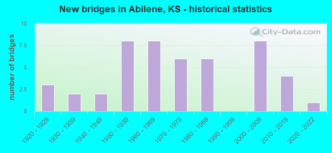
- New bridges - historical statistics
- 31920-1929
- 21930-1939
- 21940-1949
- 81950-1959
- 81960-1969
- 61970-1979
- 61980-1989
- 82000-2009
- 42010-2019
- 12020-2022
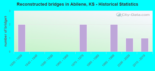
- Reconstructed bridges - Historical Statistics
- 21930-1939
- 01940-1949
- 01950-1959
- 01960-1969
- 21970-1979
- 01980-1989
- 21990-1999
- 12000-2009
- 12010-2019
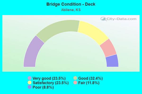
- Bridge Condition - Deck
- 23.5%Very good
- 32.4%Good
- 23.5%Satisfactory
- 11.8%Fair
- 8.8%Poor
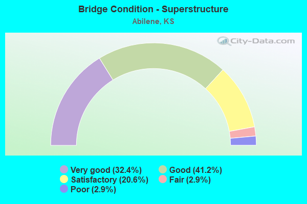
- Bridge Condition - Superstructure
- 32.4%Very good
- 41.2%Good
- 20.6%Satisfactory
- 2.9%Fair
- 2.9%Poor
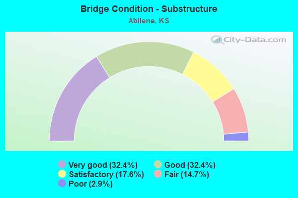
- Bridge Condition - Substructure
- 32.4%Very good
- 32.4%Good
- 17.6%Satisfactory
- 14.7%Fair
- 2.9%Poor
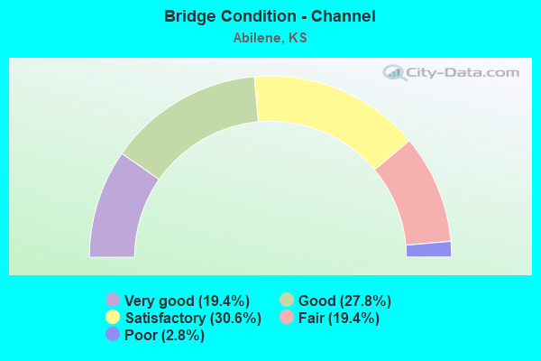
- Bridge Condition - Channel
- 19.4%Very good
- 27.8%Good
- 30.6%Satisfactory
- 19.4%Fair
- 2.8%Poor
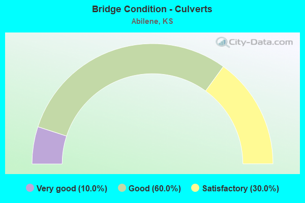
- Bridge Condition - Culverts
- 10.0%Very good
- 60.0%Good
- 30.0%Satisfactory
Find on map >> Show street view
Structure Number: 21017, Location: 2150 Eden Rd (Lat: 38.906156, Lng: -97.284083), Route carried "on" structure: County highway 185, Year Built: 1970, Year Reconstructed: 2018, Status: Open, Structure Length: 11.73m (38.48ft), Average Daily Traffic: 350 (year 2011), Truck Traffic: 11%, Average Future Daily Traffic: 420 (year 2041), Design Load: H 15, Features Intersected: SMOKY HILL RIVER
Minimum Vertical Clearance: 30.47m (99.97ft), Kilometerpoint: 0.998, Lanes on structure: 2, Owner: County Highway Agency, Approaching Roadway Width: 8.2m (26.9ft), Material/Design: Steel continuous, Design/Construction: Stringer/Multi-beam, Number Of Spans In Main Unit: 4, Number Of Approach Spans: 1, Length of Maximum Span: 29.0m (95.1ft), Curb-To-Curb Width: 8.6m (28.2ft), Out-to-Out Width: 9.2m (30.2ft)
Condition: Deck: Very good, Superstructure: Good, Substructure: Satisfactory, Channel: Satisfactory, Operating Rating: 47.1 metric tons, Method Used To Determine Operating Rating: Load Factor (LF), Inventory Rating: 28.1 metric tons, Method Used To Determine Inventory Rating: Load Factor (LF), Structural Evaluation: Equal to present minimum criteria, Deck Geometry: Equal to present minimum criteria, Waterway Adequacy: Better than present minimum criteria, Approach Roadway Alignment: Equal to present desirable criteria, Length Of Structure Improvement: 11.73m (38.48ft), Designated Inspection Frequency: Every 24 months, Underwater Inspection Frequency: Every 60 months, Inspection Date: March 2021, Underwater Inspection Date: September 2021, Bridge Improvement Cost: $102,000, Roadway Improvement Cost: $100,000, Total Project Cost: $113,000 ( Estimate for 2015), Deck Structure Type: Concrete Cast-file-Place, Wearing Surface/Protective System: Wearing Surface: Epoxy Overlay
Find on map >> Show street view
Structure Number: 21074, Location: 795 1900 Ave (Lat: 38.871494, Lng: -97.243028), Route carried "on" structure: County highway 1082, Year Built: 1968, Status: Posted for load, Structure Length: 0.91m (2.99ft), Average Daily Traffic: 215 (year 2011), Truck Traffic: 11%, Average Future Daily Traffic: 258 (year 2041), Features Intersected: CREEK
Minimum Vertical Clearance: 30.47m (99.97ft), Kilometerpoint: 0.998, Lanes on structure: 2, Owner: County Highway Agency, Approaching Roadway Width: 8.5m (27.9ft), Material/Design: Steel, Design/Construction: Stringer/Multi-beam, Number Of Spans In Main Unit: 1, Length of Maximum Span: 8.5m (27.9ft), Curb-To-Curb Width: 8.6m (28.2ft), Out-to-Out Width: 8.9m (29.2ft)
Condition: Deck: Fair, Superstructure: Satisfactory, Substructure: Fair, Channel: Satisfactory, Operating Rating: 25.2 metric tons, Method Used To Determine Operating Rating: Load Factor (LF), Inventory Rating: 15.1 metric tons, Method Used To Determine Inventory Rating: Load Factor (LF), Structural Evaluation: Meets minimum limits, Deck Geometry: Equal to present minimum criteria, Waterway Adequacy: Somewhat better than minimum adequacy, Approach Roadway Alignment: Equal to present desirable criteria, Designated Inspection Frequency: Every 24 months, Inspection Date: March 2021, Deck Structure Type: Concrete Cast-file-Place, Wearing Surface/Protective System: Wearing Surface: Bituminous
Find on map >> Show street view
Structure Number: 21075, Location: 1060 1900 Ave (Lat: 38.871569, Lng: -97.194544), Route carried "on" structure: County highway 1082, Year Built: 1930, Status: Posted for load, Structure Length: 4.38m (14.37ft), Average Daily Traffic: 140 (year 2011), Truck Traffic: 11%, Average Future Daily Traffic: 168 (year 2041), Design Load: H 15, Features Intersected: TURKEY CREEK
Minimum Vertical Clearance: 30.47m (99.97ft), Kilometerpoint: 1.000, Lanes on structure: 2, Owner: County Highway Agency, Approaching Roadway Width: 7.6m (24.9ft), Material/Design: Steel, Design/Construction: Truss - Thru, Number Of Spans In Main Unit: 1, Length of Maximum Span: 41.9m (137.5ft), Curb or Sidewalk Widths: Left: 0.2m (0.7ft), Right: 0.2m (0.7ft), Curb-To-Curb Width: 6.0m (19.7ft), Out-to-Out Width: 6.4m (21.0ft)
Condition: Deck: Fair, Superstructure: Satisfactory, Substructure: Fair, Channel: Satisfactory, Operating Rating: 5.9 metric tons, Method Used To Determine Operating Rating: Allowable Stress (AS), Inventory Rating: 3.6 metric tons, Method Used To Determine Inventory Rating: Allowable Stress (AS), Structural Evaluation: High priority of replacement, Deck Geometry: High priority of replacement, Waterway Adequacy: Equal to present desirable criteria, Approach Roadway Alignment: Equal to present minimum criteria, Bridge Posting: Required (Relationship of Operating Rating to Maximum Legal Load: > 39.9% below), Length Of Structure Improvement: 5.60m (18.37ft), Designated Inspection Frequency: Every 24 months, Critical Feature Inspection Frequency: Every 24 months, Inspection Date: March 2021, Critical Feature Inspection Date: May 2020, Bridge Improvement Cost: $490,000, Roadway Improvement Cost: $100,000, Total Project Cost: $600,000 ( Estimate for 2015), Deck Structure Type: Concrete Cast-file-Place
Find on map >> Show street view
Structure Number: 21076, Location: 1775 Jeep Rd (Lat: 38.853139, Lng: -97.167483), Route carried "on" structure: County highway 1084, Year Built: 1969, Status: Open, Structure Length: 1.14m (3.74ft), Average Daily Traffic: 450 (year 2011), Truck Traffic: 11%, Average Future Daily Traffic: 540 (year 2041), Design Load: H 15, Features Intersected: CREEK
Minimum Vertical Clearance: 30.47m (99.97ft), Kilometerpoint: 0.998, Lanes on structure: 2, Owner: County Highway Agency, Approaching Roadway Width: 8.0m (26.2ft), Material/Design: Concrete, Design/Construction: Culvert, Number Of Spans In Main Unit: 3, Length of Maximum Span: 3.7m (12.1ft)
Condition: Channel: Satisfactory, Culverts: Good, Operating Rating: 40.0 metric tons, Method Used To Determine Operating Rating: Load Factor (LF), Inventory Rating: 23.9 metric tons, Method Used To Determine Inventory Rating: Load Factor (LF), Structural Evaluation: Equal to present minimum criteria, Waterway Adequacy: Somewhat better than minimum adequacy, Approach Roadway Alignment: Equal to present desirable criteria, Designated Inspection Frequency: Every 24 months, Inspection Date: March 2021
Find on map >> Show street view
Structure Number: 21077, Location: 2135 Jeep Rd (Lat: 38.902778, Lng: -97.167239), Route carried "on" structure: County highway 1084, Year Built: 1979, Status: Open, Structure Length: 11.63m (38.16ft), Average Daily Traffic: 780 (year 2011), Truck Traffic: 11%, Average Future Daily Traffic: 936 (year 2041), Design Load: H 20, Features Intersected: SMOKY HILL RIVER
Minimum Vertical Clearance: 30.47m (99.97ft), Kilometerpoint: 0.998, Lanes on structure: 2, Owner: County Highway Agency, Approaching Roadway Width: 7.9m (25.9ft), Material/Design: Steel continuous, Design/Construction: Stringer/Multi-beam, Number Of Spans In Main Unit: 4, Length of Maximum Span: 32.0m (105.0ft), Curb-To-Curb Width: 8.5m (27.9ft), Out-to-Out Width: 9.1m (29.9ft)
Condition: Deck: Satisfactory, Superstructure: Very good, Substructure: Satisfactory, Channel: Satisfactory, Operating Rating: 38.8 metric tons, Method Used To Determine Operating Rating: Load Factor (LF), Inventory Rating: 22.7 metric tons, Method Used To Determine Inventory Rating: Load Factor (LF), Structural Evaluation: Equal to present minimum criteria, Deck Geometry: Somewhat better than minimum adequacy, Waterway Adequacy: Equal to present minimum criteria, Approach Roadway Alignment: Equal to present desirable criteria, Designated Inspection Frequency: Every 24 months, Underwater Inspection Frequency: Every 60 months, Inspection Date: March 2021, Underwater Inspection Date: September 2021, Deck Structure Type: Concrete Cast-file-Place, Wearing Surface/Protective System: Wearing Surface: Epoxy Overlay
Find on map >> Show street view
Structure Number: 21095, Location: 590 Old Hwy 40 (Lat: 38.906956, Lng: -97.281644), Route carried "on" structure: County highway 1816, Year Built: 2010, Status: Open, Structure Length: 3.12m (10.24ft), Average Daily Traffic: 1,905 (year 2011), Truck Traffic: 11%, Average Future Daily Traffic: 2,286 (year 2041), Design Load: HL 93, Features Intersected: CREEK
Minimum Vertical Clearance: 30.47m (99.97ft), Kilometerpoint: 0.998, Lanes on structure: 2, Owner: County Highway Agency, Approaching Roadway Width: 8.5m (27.9ft), Material/Design: Concrete continuous, Design/Construction: Slab, Number Of Spans In Main Unit: 3, Length of Maximum Span: 12.2m (40.0ft), Curb-To-Curb Width: 11.0m (36.1ft), Out-to-Out Width: 11.6m (38.1ft)
Condition: Deck: Very good, Superstructure: Very good, Substructure: Very good, Channel: Very good, Operating Rating: 34.7 metric tons, Method Used To Determine Operating Rating: Load and Resistance Factor Rating (LRFR) rating reported by rating factor(RF) method using HL-93 loadings, Inventory Rating: 26.9 metric tons, Method Used To Determine Inventory Rating: Load and Resistance Factor Rating (LRFR) rating reported by rating factor(RF) method using HL-93 loadings, Structural Evaluation: Equal to present minimum criteria, Deck Geometry: Equal to present minimum criteria, Waterway Adequacy: Equal to present desirable criteria, Approach Roadway Alignment: Equal to present desirable criteria, Designated Inspection Frequency: Every 24 months, Inspection Date: April 2021, Deck Structure Type: Concrete Cast-file-Place, Wearing Surface/Protective System: Wearing Surface: Monolithic Concrete
Find on map >> Show street view
Structure Number: 21096, Location: 753 Old Hwy 40 (Lat: 38.908000, Lng: -97.249675), Route carried "on" structure: County highway 1816, Year Built: 1925, Status: Open, Structure Length: 0.79m (2.59ft), Average Daily Traffic: 2,035 (year 2011), Truck Traffic: 11%, Average Future Daily Traffic: 2,442 (year 2041), Features Intersected: CREEK
Minimum Vertical Clearance: 30.47m (99.97ft), Kilometerpoint: 1.000, Lanes on structure: 2, Owner: County Highway Agency, Approaching Roadway Width: 8.6m (28.2ft), Material/Design: Concrete, Design/Construction: Culvert, Number Of Spans In Main Unit: 4, Length of Maximum Span: 1.8m (5.9ft), Curb-To-Curb Width: 8.3m (27.2ft), Out-to-Out Width: 9.0m (29.5ft)
Condition: Channel: Fair, Culverts: Satisfactory, Operating Rating: 26.7 metric tons, Method Used To Determine Operating Rating: Load Factor (LF), Inventory Rating: 16.0 metric tons, Method Used To Determine Inventory Rating: Load Factor (LF), Structural Evaluation: Meets minimum limits, Deck Geometry: High priority of corrective action, Waterway Adequacy: Meets minimum limits, Approach Roadway Alignment: Equal to present desirable criteria, Length Of Structure Improvement: 1.12m (3.67ft), Designated Inspection Frequency: Every 24 months, Inspection Date: April 2021, Bridge Improvement Cost: $100,000, Roadway Improvement Cost: $100,000, Total Project Cost: $210,000 ( Estimate for 2015)
Find on map >> Show street view
Structure Number: 21097, Location: 900 Old Hwy 40 (Lat: 38.929833, Lng: -97.227961), Route carried "on" structure: County highway 1816, Year Built: 1938, Status: Open, Structure Length: 6.73m (22.08ft), Average Daily Traffic: 2,035 (year 2011), Truck Traffic: 11%, Average Future Daily Traffic: 2,442 (year 2041), Design Load: H 15, Features Intersected: MUD CREEK
Minimum Vertical Clearance: 30.47m (99.97ft), Kilometerpoint: 1.000, Lanes on structure: 2, Owner: County Highway Agency, Approaching Roadway Width: 14.3m (46.9ft), Material/Design: Steel continuous, Design/Construction: Stringer/Multi-beam, Number Of Spans In Main Unit: 3, Length of Maximum Span: 24.4m (80.1ft), Curb-To-Curb Width: 7.3m (24.0ft), Out-to-Out Width: 8.4m (27.6ft)
Condition: Deck: Poor, Superstructure: Satisfactory, Substructure: Satisfactory, Channel: Fair, Operating Rating: 34.1 metric tons, Method Used To Determine Operating Rating: Load Factor (LF), Inventory Rating: 20.4 metric tons, Method Used To Determine Inventory Rating: Load Factor (LF), Structural Evaluation: Somewhat better than minimum adequacy, Deck Geometry: High priority of replacement, Waterway Adequacy: Better than present minimum criteria, Approach Roadway Alignment: Equal to present desirable criteria, Length Of Structure Improvement: 8.19m (26.87ft), Designated Inspection Frequency: Every 24 months, Inspection Date: April 2021, Bridge Improvement Cost: $720,000, Roadway Improvement Cost: $100,000, Total Project Cost: $830,000 ( Estimate for 2015), Deck Structure Type: Concrete Cast-file-Place
Find on map >> Show street view
Structure Number: 21098, Location: 428 NW 14th St Abilene (Lat: 38.929836, Lng: -97.219964), Route carried "on" structure: City street 1816, Year Built: 1951, Status: Open, Structure Length: 0.76m (2.49ft), Average Daily Traffic: 2,035 (year 2011), Truck Traffic: 2%, Average Future Daily Traffic: 2,442 (year 2041), Design Load: H 20, Features Intersected: STREET
Minimum Vertical Clearance: 30.47m (99.97ft), Kilometerpoint: 0.998, Lanes on structure: 2, Owner: City or Municipal Highway Agency, Approaching Roadway Width: 11.5m (37.7ft), Material/Design: Concrete, Design/Construction: Culvert, Number Of Spans In Main Unit: 2, Length of Maximum Span: 3.8m (12.5ft), Curb-To-Curb Width: 13.7m (44.9ft), Out-to-Out Width: 14.3m (46.9ft)
Condition: Culverts: Good, Operating Rating: 28.4 metric tons, Method Used To Determine Operating Rating: Load Factor (LF), Inventory Rating: 17.0 metric tons, Method Used To Determine Inventory Rating: Load Factor (LF), Structural Evaluation: Meets minimum limits, Deck Geometry: Superior to present desirable criteria, Approach Roadway Alignment: Equal to present desirable criteria, Length Of Structure Improvement: 1.98m (6.50ft), Designated Inspection Frequency: Every 24 months, Inspection Date: March 2021, Bridge Improvement Cost: $170,000, Roadway Improvement Cost: $100,000, Total Project Cost: $280,000 ( Estimate for 2015)
Find on map >> Show street view
Structure Number: 21099, Location: 1022 Old Hwy 40 (Lat: 38.929797, Lng: -97.200081), Route carried "on" structure: County highway 1816, Year Built: 1920, Year Reconstructed: 1939, Status: Posted for load, Structure Length: 0.77m (2.53ft), Average Daily Traffic: 1,705 (year 2011), Truck Traffic: 11%, Average Future Daily Traffic: 2,046 (year 2041), Design Load: H 15, Features Intersected: CREEK
Minimum Vertical Clearance: 30.47m (99.97ft), Kilometerpoint: 1.000, Lanes on structure: 2, Owner: County Highway Agency, Approaching Roadway Width: 8.3m (27.2ft), Material/Design: Concrete continuous, Design/Construction: Slab, Number Of Spans In Main Unit: 2, Length of Maximum Span: 3.7m (12.1ft), Curb-To-Curb Width: 9.7m (31.8ft), Out-to-Out Width: 10.6m (34.8ft)
Condition: Deck: Poor, Superstructure: Poor, Substructure: Fair, Channel: Good, Operating Rating: 12.2 metric tons, Method Used To Determine Operating Rating: Load Factor (LF), Inventory Rating: 7.3 metric tons, Method Used To Determine Inventory Rating: Load Factor (LF), Structural Evaluation: High priority of replacement, Deck Geometry: Somewhat better than minimum adequacy, Waterway Adequacy: Somewhat better than minimum adequacy, Approach Roadway Alignment: Equal to present desirable criteria, Bridge Posting: Required (Relationship of Operating Rating to Maximum Legal Load: > 39.9% below), Length Of Structure Improvement: 1.51m (4.95ft), Designated Inspection Frequency: Every 24 months, Inspection Date: April 2021, Bridge Improvement Cost: $130,000, Roadway Improvement Cost: $100,000, Total Project Cost: $240,000 ( Estimate for 2015), Deck Structure Type: Concrete Cast-file-Place, Wearing Surface/Protective System: Wearing Surface: Bituminous
Find on map >> Show street view
Structure Number: 211, Location: 1098 Old Hwy 40 (Lat: 38.929783, Lng: -97.186078), Route carried "on" structure: County highway 1816, Year Built: 1920, Year Reconstructed: 1939, Status: Posted for load, Structure Length: 0.76m (2.49ft), Average Daily Traffic: 1,705 (year 2011), Truck Traffic: 11%, Average Future Daily Traffic: 2,045 (year 2041), Design Load: H 15, Features Intersected: CREEK
Minimum Vertical Clearance: 30.47m (99.97ft), Kilometerpoint: 1.000, Lanes on structure: 2, Owner: County Highway Agency, Approaching Roadway Width: 8.6m (28.2ft), Material/Design: Concrete continuous, Design/Construction: Slab, Number Of Spans In Main Unit: 2, Length of Maximum Span: 3.7m (12.1ft), Curb-To-Curb Width: 10.2m (33.5ft), Out-to-Out Width: 11.0m (36.1ft)
Condition: Deck: Poor, Superstructure: Fair, Substructure: Poor, Channel: Satisfactory, Operating Rating: 15.7 metric tons, Method Used To Determine Operating Rating: Load Factor (LF), Inventory Rating: 9.4 metric tons, Method Used To Determine Inventory Rating: Load Factor (LF), Structural Evaluation: High priority of replacement, Deck Geometry: Somewhat better than minimum adequacy, Waterway Adequacy: Meets minimum limits, Approach Roadway Alignment: Equal to present desirable criteria, Bridge Posting: Required (Relationship of Operating Rating to Maximum Legal Load: 20.0 - 29.9% below), Length Of Structure Improvement: 1.51m (4.95ft), Designated Inspection Frequency: Every 24 months, Inspection Date: April 2021, Bridge Improvement Cost: $130,000, Roadway Improvement Cost: $100,000, Total Project Cost: $240,000 ( Estimate for 2015), Deck Structure Type: Concrete Cast-file-Place, Wearing Surface/Protective System: Wearing Surface: Bituminous
Find on map >> Show street view
Structure Number: 211055, Location: 1878 Old Hwy 40 (Lat: 38.966497, Lng: -97.042989), Route carried "on" structure: County highway 1816, Year Built: 2012, Status: Open, Structure Length: 0.63m (2.07ft), Average Daily Traffic: 1,050 (year 2011), Truck Traffic: 11%, Average Future Daily Traffic: 1,260 (year 2041), Design Load: HS 20, Features Intersected: CREEK
Minimum Vertical Clearance: 30.47m (99.97ft), Kilometerpoint: 0.000, Lanes on structure: 2, Owner: County Highway Agency, Approaching Roadway Width: 7.6m (24.9ft), Material/Design: Concrete, Design/Construction: Culvert, Number Of Spans In Main Unit: 2, Length of Maximum Span: 3.0m (9.8ft), Curb or Sidewalk Widths: Left: 0.2m (0.7ft), Right: 0.2m (0.7ft), Curb-To-Curb Width: 18.9m (62.0ft), Out-to-Out Width: 19.4m (63.6ft)
Condition: Channel: Very good, Culverts: Very good, Operating Rating: 56.8 metric tons, Method Used To Determine Operating Rating: Load Factor (LF), Inventory Rating: 34.0 metric tons, Method Used To Determine Inventory Rating: Load Factor (LF), Structural Evaluation: Equal to present desirable criteria, Deck Geometry: Superior to present desirable criteria, Waterway Adequacy: Equal to present desirable criteria, Approach Roadway Alignment: Equal to present desirable criteria, Designated Inspection Frequency: Every 24 months, Inspection Date: April 2021, Deck Structure Type: Concrete Cast-file-Place, Wearing Surface/Protective System: Wearing Surface: Bituminous
Find on map >> Show street view
Structure Number: 21112, Location: 650 1900 Ave (Lat: 38.871386, Lng: -97.269122), Route carried "on" structure: Interstate 1082, Year Built: 2015, Status: Open, Structure Length: 4.65m (15.26ft), Average Daily Traffic: 200 (year 2015), Truck Traffic: 10%, Average Future Daily Traffic: 205 (year 2041), Design Load: HL 93, Features Intersected: HOLLAND CREEK
Minimum Vertical Clearance: 30.47m (99.97ft), Kilometerpoint: 0.000, Lanes on structure: 2, Owner: County Highway Agency, Approaching Roadway Width: 8.5m (27.9ft), Material/Design: Concrete continuous, Design/Construction: Slab, Number Of Spans In Main Unit: 3, Length of Maximum Span: 18.3m (60.0ft), Curb-To-Curb Width: 8.5m (27.9ft), Out-to-Out Width: 9.1m (29.9ft)
Condition: Deck: Very good, Superstructure: Very good, Substructure: Very good, Channel: Very good, Operating Rating: 75.4 metric tons, Method Used To Determine Operating Rating: Load and Resistance Factor (LRFR), Inventory Rating: 45.4 metric tons, Method Used To Determine Inventory Rating: Load and Resistance Factor (LRFR), Structural Evaluation: Equal to present desirable criteria, Deck Geometry: Equal to present minimum criteria, Waterway Adequacy: Equal to present desirable criteria, Approach Roadway Alignment: Equal to present desirable criteria, Designated Inspection Frequency: Every 24 months, Inspection Date: March 2021, Deck Structure Type: Concrete Cast-file-Place, Wearing Surface/Protective System: Wearing Surface: Epoxy Overlay, Membrane: Epoxy, Deck Protection: Epoxy Coated Reinforcing
Find on map >> Show street view
Structure Number: 210827804548, Location: 1926 Fair Rd (Lat: 38.875422, Lng: -97.265556), Route carried "on" structure: County highway , Year Built: 1965, Status: Posted for load, Structure Length: 2.12m (6.96ft), Average Daily Traffic: 15 (year 2011), Average Future Daily Traffic: 20 (year 2041), Features Intersected: HOLLAND CREEK, Facility Carried by Structure: Fair F18-E75-S74
Minimum Vertical Clearance: 30.47m (99.97ft), Kilometerpoint: 0.998, Lanes on structure: 2, Owner: County Highway Agency, Approaching Roadway Width: 6.0m (19.7ft), Material/Design: Steel, Design/Construction: Stringer/Multi-beam, Number Of Spans In Main Unit: 3, Length of Maximum Span: 11.9m (39.0ft), Curb-To-Curb Width: 6.1m (20.0ft), Out-to-Out Width: 6.1m (20.0ft)
Condition: Deck: Satisfactory, Superstructure: Satisfactory, Substructure: Fair, Channel: Fair, Operating Rating: 37.8 metric tons, Method Used To Determine Operating Rating: Load Factor (LF), Inventory Rating: 22.7 metric tons, Method Used To Determine Inventory Rating: Load Factor (LF), Structural Evaluation: Somewhat better than minimum adequacy, Deck Geometry: Somewhat better than minimum adequacy, Waterway Adequacy: Equal to present minimum criteria, Approach Roadway Alignment: Equal to present desirable criteria, Length Of Structure Improvement: 2.19m (7.19ft), Designated Inspection Frequency: Every 12 months, Inspection Date: March 2021, Bridge Improvement Cost: $126,000, Roadway Improvement Cost: $35,000, Total Project Cost: $189,000, Deck Structure Type: Corrugated Steel, Wearing Surface/Protective System: Wearing Surface: Gravel
Find on map >> Show street view
Structure Number: 21082920442, Location: 720 2600 Ave (Lat: 38.973358, Lng: -97.257131), Route carried "on" structure: County highway , Year Built: 2000, Status: Open, Structure Length: 1.13m (3.71ft), Average Daily Traffic: 45 (year 2011), Average Future Daily Traffic: 54 (year 2041), Design Load: HS 20, Features Intersected: TRIB. TO MUD CREEK, Facility Carried by Structure: 2600 Ave (G12-E20)
Minimum Vertical Clearance: 30.47m (99.97ft), Kilometerpoint: 0.998, Lanes on structure: 2, Owner: County Highway Agency, Approaching Roadway Width: 7.9m (25.9ft), Material/Design: Steel, Design/Construction: Stringer/Multi-beam, Number Of Spans In Main Unit: 1, Length of Maximum Span: 10.7m (35.1ft), Curb-To-Curb Width: 7.9m (25.9ft), Out-to-Out Width: 7.9m (25.9ft)
Condition: Deck: Very good, Superstructure: Very good, Substructure: Very good, Channel: Very good, Operating Rating: 52.6 metric tons, Method Used To Determine Operating Rating: Load Factor (LF), Inventory Rating: 31.8 metric tons, Method Used To Determine Inventory Rating: Load Factor (LF), Structural Evaluation: Better than present minimum criteria, Deck Geometry: Equal to present minimum criteria, Waterway Adequacy: Equal to present desirable criteria, Approach Roadway Alignment: Equal to present desirable criteria, Designated Inspection Frequency: Every 24 months, Inspection Date: March 2021, Deck Structure Type: Corrugated Steel, Wearing Surface/Protective System: Wearing Surface: Bituminous
Find on map >> Show street view
Structure Number: 21082990442, Location: 790 2600 Ave (Lat: 38.973686, Lng: -97.242375), Route carried "on" structure: County highway , Year Built: 1977, Status: Posted for load, Structure Length: 0.62m (2.03ft), Average Daily Traffic: 30 (year 2011), Average Future Daily Traffic: 36 (year 2041), Design Load: H 20, Features Intersected: TRIB. TO MUD CREEK, Facility Carried by Structure: 2600 Ave (G12-E90)
Minimum Vertical Clearance: 30.47m (99.97ft), Kilometerpoint: 0.998, Lanes on structure: 2, Owner: County Highway Agency, Approaching Roadway Width: 7.6m (24.9ft), Material/Design: Concrete, Design/Construction: Culvert, Number Of Spans In Main Unit: 1, Length of Maximum Span: 6.2m (20.3ft), Curb-To-Curb Width: 7.3m (24.0ft), Out-to-Out Width: 8.3m (27.2ft)
Condition: Channel: Good, Culverts: Satisfactory, Operating Rating: 29.7 metric tons, Method Used To Determine Operating Rating: Load Testing, Inventory Rating: 22.5 metric tons, Method Used To Determine Inventory Rating: Load Testing, Structural Evaluation: Equal to present minimum criteria, Deck Geometry: Equal to present minimum criteria, Waterway Adequacy: Equal to present minimum criteria, Approach Roadway Alignment: Equal to present desirable criteria, Designated Inspection Frequency: Every 24 months, Inspection Date: March 2021
Find on map >> Show street view
Structure Number: 21083100442, Location: 800 2600 Ave (Lat: 38.973794, Lng: -97.241669), Route carried "on" structure: County highway , Year Built: 1977, Status: Open, Structure Length: 3.25m (10.66ft), Average Daily Traffic: 30 (year 2011), Average Future Daily Traffic: 30 (year 2041), Design Load: H 20, Features Intersected: MUD CREEK, Facility Carried by Structure: 2600 Ave. H12
Minimum Vertical Clearance: 30.47m (99.97ft), Kilometerpoint: 0.998, Lanes on structure: 2, Owner: County Highway Agency, Approaching Roadway Width: 7.6m (24.9ft), Material/Design: Concrete continuous, Design/Construction: Slab, Number Of Spans In Main Unit: 3, Length of Maximum Span: 12.2m (40.0ft), Curb-To-Curb Width: 7.3m (24.0ft), Out-to-Out Width: 7.9m (25.9ft)
Condition: Deck: Good, Superstructure: Good, Substructure: Fair, Channel: Poor, Operating Rating: 75.5 metric tons, Method Used To Determine Operating Rating: Load Factor (LF), Inventory Rating: 45.2 metric tons, Method Used To Determine Inventory Rating: Load Factor (LF), Structural Evaluation: Somewhat better than minimum adequacy, Deck Geometry: Equal to present minimum criteria, Waterway Adequacy: Equal to present minimum criteria, Approach Roadway Alignment: Equal to present desirable criteria, Designated Inspection Frequency: Every 24 months, Inspection Date: March 2021, Deck Structure Type: Concrete Cast-file-Place
Find on map >> Show street view
Structure Number: 21083170442, Location: 875 2600 Ave (Lat: 38.973328, Lng: -97.227956), Route carried "on" structure: County highway 183, Year Built: 2021, Status: Open, Structure Length: 1.22m (4.00ft), Average Daily Traffic: 30 (year 2011), Average Future Daily Traffic: 36 (year 2042), Design Load: HL 93, Features Intersected: TRIBUTARY TO MUD CREEK, Facility Carried by Structure: 2600 Ave (H12-E75)
Minimum Vertical Clearance: 30.47m (99.97ft), Kilometerpoint: 0.000, Lanes on structure: 2, Owner: County Highway Agency, Approaching Roadway Width: 6.7m (22.0ft), Skew: 2 degrees, Design/Construction: Stringer/Multi-beam, Number Of Spans In Main Unit: 1, Length of Maximum Span: 11.9m (39.0ft), Curb-To-Curb Width: 7.3m (24.0ft), Out-to-Out Width: 7.3m (24.0ft)
Condition: Deck: Very good, Superstructure: Very good, Substructure: Very good, Channel: Satisfactory, Operating Rating: 58.0 metric tons, Method Used To Determine Operating Rating: Load and Resistance Factor Rating (LRFR) rating reported by rating factor(RF) method using HL-93 loadings, Inventory Rating: 44.7 metric tons, Method Used To Determine Inventory Rating: Load Factor (LF) rating reported by rating factor (RF) method using MS18 loading, Structural Evaluation: Equal to present desirable criteria, Deck Geometry: Equal to present minimum criteria, Waterway Adequacy: Equal to present minimum criteria, Approach Roadway Alignment: Equal to present desirable criteria, Designated Inspection Frequency: Every 24 months, Inspection Date: December 2021, Deck Structure Type: Corrugated Steel, Wearing Surface/Protective System: Wearing Surface: Gravel
Find on map >> Show street view
Structure Number: 21083190442, Location: 880 2600 Ave (Lat: 38.973319, Lng: -97.226528), Route carried "on" structure: County highway 183, Year Built: 2019, Status: Open, Structure Length: 0.91m (2.99ft), Average Daily Traffic: 30 (year 2019), Average Future Daily Traffic: 35 (year 2041), Design Load: HS 20, Features Intersected: CREEK, Facility Carried by Structure: 2600 Ave (H12-E80)
Minimum Vertical Clearance: 30.47m (99.97ft), Kilometerpoint: 0.000, Lanes on structure: 2, Owner: County Highway Agency, Approaching Roadway Width: 6.5m (21.3ft), Skew: 1 degrees, Material/Design: Steel, Design/Construction: Stringer/Multi-beam, Number Of Spans In Main Unit: 1, Length of Maximum Span: 8.9m (29.2ft), Curb-To-Curb Width: 7.2m (23.6ft), Out-to-Out Width: 7.3m (24.0ft)
Condition: Deck: Very good, Superstructure: Very good, Substructure: Very good, Channel: Fair, Operating Rating: 58.4 metric tons, Method Used To Determine Operating Rating: Load Factor (LF), Inventory Rating: 34.9 metric tons, Method Used To Determine Inventory Rating: Load Factor (LF), Structural Evaluation: Equal to present desirable criteria, Deck Geometry: Somewhat better than minimum adequacy, Waterway Adequacy: Somewhat better than minimum adequacy, Approach Roadway Alignment: Equal to present desirable criteria, Designated Inspection Frequency: Every 24 months, Inspection Date: March 2021, Deck Structure Type: Concrete Cast-file-Place, Wearing Surface/Protective System: Wearing Surface: Monolithic Concrete
Find on map >> Show street view
Structure Number: 21083300442, Location: 2600 Gulf Rd (Lat: 38.973658, Lng: -97.222953), Route carried "on" structure: County highway , Year Built: 1978, Status: Open, Structure Length: 0.69m (2.26ft), Average Daily Traffic: 40 (year 2011), Average Future Daily Traffic: 43 (year 2041), Features Intersected: CREEK, Facility Carried by Structure: Gulf Rd I12
Minimum Vertical Clearance: 30.47m (99.97ft), Kilometerpoint: 0.998, Lanes on structure: 2, Owner: County Highway Agency, Approaching Roadway Width: 7.7m (25.3ft), Material/Design: Steel, Design/Construction: Stringer/Multi-beam, Number Of Spans In Main Unit: 1, Length of Maximum Span: 6.2m (20.3ft), Curb-To-Curb Width: 6.9m (22.6ft), Out-to-Out Width: 7.3m (24.0ft)
Condition: Deck: Satisfactory, Superstructure: Good, Substructure: Satisfactory, Channel: Satisfactory, Operating Rating: 54.0 metric tons, Method Used To Determine Operating Rating: Allowable Stress (AS), Inventory Rating: 38.7 metric tons, Method Used To Determine Inventory Rating: Allowable Stress (AS), Structural Evaluation: Equal to present minimum criteria, Deck Geometry: Somewhat better than minimum adequacy, Waterway Adequacy: Equal to present minimum criteria, Approach Roadway Alignment: Equal to present minimum criteria, Designated Inspection Frequency: Every 24 months, Inspection Date: March 2021, Deck Structure Type: Corrugated Steel, Wearing Surface/Protective System: Wearing Surface: Gravel
Find on map >> Show street view
Structure Number: 21083300452, Location: 900 2100 Ave (Lat: 38.901139, Lng: -97.222539), Route carried "on" structure: County highway , Year Built: 1958, Status: Open, Structure Length: 5.21m (17.09ft), Average Daily Traffic: 125 (year 2011), Truck Traffic: 15%, Average Future Daily Traffic: 150 (year 2041), Design Load: H 15, Features Intersected: MUD CREEK, Facility Carried by Structure: 2100 Ave. I17
Minimum Vertical Clearance: 30.47m (99.97ft), Kilometerpoint: 0.998, Lanes on structure: 2, Owner: County Highway Agency, Approaching Roadway Width: 7.9m (25.9ft), Material/Design: Steel continuous, Design/Construction: Stringer/Multi-beam, Number Of Spans In Main Unit: 3, Length of Maximum Span: 21.9m (71.9ft), Curb or Sidewalk Widths: Left: 0.3m (1.0ft), Right: 0.3m (1.0ft), Curb-To-Curb Width: 6.1m (20.0ft), Out-to-Out Width: 6.8m (22.3ft)
Condition: Deck: Satisfactory, Superstructure: Good, Substructure: Satisfactory, Channel: Fair, Operating Rating: 37.5 metric tons, Method Used To Determine Operating Rating: Load Factor (LF), Inventory Rating: 22.4 metric tons, Method Used To Determine Inventory Rating: Load Factor (LF), Structural Evaluation: Equal to present minimum criteria, Deck Geometry: Meets minimum limits, Waterway Adequacy: Equal to present minimum criteria, Approach Roadway Alignment: Somewhat better than minimum adequacy, Length Of Structure Improvement: 6.18m (20.28ft), Designated Inspection Frequency: Every 24 months, Inspection Date: March 2021, Bridge Improvement Cost: $540,000, Roadway Improvement Cost: $100,000, Total Project Cost: $650,000, Deck Structure Type: Concrete Cast-file-Place
Find on map >> Show street view
Structure Number: 2108337044, Location: 970 2700 Ave (Lat: 38.987856, Lng: -97.209742), Route carried "on" structure: County highway , Year Built: 1940, Status: Posted for load, Structure Length: 0.78m (2.56ft), Average Daily Traffic: 25 (year 2007), Average Future Daily Traffic: 30 (year 2041), Features Intersected: CREEK, Facility Carried by Structure: 2700 Ave (I11-E70)
Minimum Vertical Clearance: 30.47m (99.97ft), Kilometerpoint: 1.000, Lanes on structure: 2, Owner: County Highway Agency, Approaching Roadway Width: 7.9m (25.9ft), Material/Design: Concrete, Design/Construction: Culvert, Number Of Spans In Main Unit: 3, Length of Maximum Span: 2.4m (7.9ft), Curb-To-Curb Width: 8.4m (27.6ft), Out-to-Out Width: 9.0m (29.5ft)
Condition: Channel: Satisfactory, Culverts: Good, Operating Rating: 24.3 metric tons, Method Used To Determine Operating Rating: Allowable Stress (AS), Inventory Rating: 16.2 metric tons, Method Used To Determine Inventory Rating: Allowable Stress (AS), Structural Evaluation: Somewhat better than minimum adequacy, Deck Geometry: Equal to present minimum criteria, Waterway Adequacy: Equal to present minimum criteria, Approach Roadway Alignment: Equal to present desirable criteria, Bridge Posting: Required (Relationship of Operating Rating to Maximum Legal Load: 0.1 - 9.9% below), Designated Inspection Frequency: Every 24 months, Inspection Date: March 2021
Find on map >> Show street view
Structure Number: 210835004382, Location: 2785 Hawk Rd (Lat: 38.999817, Lng: -97.203819), Route carried "on" structure: County highway , Year Built: 1940, Status: Posted for load, Structure Length: 1.08m (3.54ft), Average Daily Traffic: 40 (year 2011), Average Future Daily Traffic: 48 (year 2041), Features Intersected: STREAM, Facility Carried by Structure: Hawk Rd (J10-S15)
Minimum Vertical Clearance: 30.47m (99.97ft), Kilometerpoint: 0.998, Lanes on structure: 2, Owner: County Highway Agency, Approaching Roadway Width: 8.0m (26.2ft), Material/Design: Concrete, Design/Construction: Culvert, Number Of Spans In Main Unit: 4, Length of Maximum Span: 2.4m (7.9ft), Curb-To-Curb Width: 8.4m (27.6ft), Out-to-Out Width: 9.1m (29.9ft)
Condition: Channel: Fair, Culverts: Good, Operating Rating: 24.3 metric tons, Method Used To Determine Operating Rating: Allowable Stress (AS), Inventory Rating: 16.2 metric tons, Method Used To Determine Inventory Rating: Allowable Stress (AS), Structural Evaluation: Somewhat better than minimum adequacy, Deck Geometry: Equal to present minimum criteria, Waterway Adequacy: Equal to present minimum criteria, Approach Roadway Alignment: Equal to present desirable criteria, Length Of Structure Improvement: 1.22m (4.00ft), Designated Inspection Frequency: Every 24 months, Inspection Date: March 2021
Find on map >> Show street view
Structure Number: 21083570458, Location: 1070 1800 Ave (Lat: 38.856828, Lng: -97.191944), Route carried "on" structure: County highway , Year Built: 1981, Status: Open, Structure Length: 6.46m (21.19ft), Average Daily Traffic: 35 (year 2011), Average Future Daily Traffic: 42 (year 2041), Design Load: H 20, Features Intersected: TURKEY CREEK, Facility Carried by Structure: 1800 Ave (J20-E70)
Minimum Vertical Clearance: 30.47m (99.97ft), Kilometerpoint: 1.000, Lanes on structure: 2, Owner: County Highway Agency, Approaching Roadway Width: 6.7m (22.0ft), Material/Design: Prestressed concrete continuous, Design/Construction: Tee Beam, Number Of Spans In Main Unit: 4, Length of Maximum Span: 16.0m (52.5ft), Curb-To-Curb Width: 7.3m (24.0ft), Out-to-Out Width: 7.9m (25.9ft)
Condition: Deck: Good, Superstructure: Good, Substructure: Satisfactory, Channel: Satisfactory, Operating Rating: 42.5 metric tons, Method Used To Determine Operating Rating: Load Factor (LF), Inventory Rating: 25.4 metric tons, Method Used To Determine Inventory Rating: Load Factor (LF), Structural Evaluation: Equal to present minimum criteria, Deck Geometry: Equal to present minimum criteria, Waterway Adequacy: Equal to present desirable criteria, Approach Roadway Alignment: Equal to present desirable criteria, Designated Inspection Frequency: Every 24 months, Inspection Date: March 2021, Other Special Inspection Date: November 2020, Deck Structure Type: Concrete Cast-file-Place
Find on map >> Show street view
Structure Number: 210835804543, Location: 1089 2000 Ave (Lat: 38.882383, Lng: -97.188336), Route carried "on" structure: County highway , Year Built: 1978, Status: Open, Structure Length: 6.17m (20.24ft), Average Daily Traffic: 45 (year 2011), Average Future Daily Traffic: 54 (year 2041), Design Load: H 20, Features Intersected: TURKEY CREEK, Facility Carried by Structure: LOCAL J18-S25-E80
Minimum Vertical Clearance: 30.47m (99.97ft), Kilometerpoint: 0.998, Lanes on structure: 2, Owner: County Highway Agency, Approaching Roadway Width: 6.8m (22.3ft), Skew: 3 degrees, Material/Design: Prestressed concrete continuous, Design/Construction: Tee Beam, Number Of Spans In Main Unit: 4, Length of Maximum Span: 15.2m (49.9ft), Curb-To-Curb Width: 7.3m (24.0ft), Out-to-Out Width: 7.9m (25.9ft)
Condition: Deck: Satisfactory, Superstructure: Good, Substructure: Good, Channel: Fair, Operating Rating: 34.8 metric tons, Method Used To Determine Operating Rating: Load Factor (LF), Inventory Rating: 18.0 metric tons, Method Used To Determine Inventory Rating: Load Factor (LF), Structural Evaluation: Somewhat better than minimum adequacy, Deck Geometry: Equal to present minimum criteria, Waterway Adequacy: Equal to present desirable criteria, Approach Roadway Alignment: Equal to present desirable criteria, Designated Inspection Frequency: Every 24 months, Inspection Date: March 2021, Other Special Inspection Date: November 2020, Deck Structure Type: Concrete Cast-file-Place
Find on map >> Show street view
Structure Number: 210837004585, Location: 1750 Indy Rd (Lat: 38.852200, Lng: -97.186308), Route carried "on" structure: County highway , Year Built: 1982, Status: Open, Structure Length: 6.16m (20.21ft), Average Daily Traffic: 45 (year 2011), Average Future Daily Traffic: 54 (year 2041), Design Load: H 20, Features Intersected: TURKEY CREEK, Facility Carried by Structure: Indy Rd (K20-S50)
Minimum Vertical Clearance: 30.47m (99.97ft), Kilometerpoint: 1.000, Lanes on structure: 2, Owner: County Highway Agency, Approaching Roadway Width: 7.1m (23.3ft), Material/Design: Prestressed concrete continuous, Design/Construction: Tee Beam, Number Of Spans In Main Unit: 4, Length of Maximum Span: 15.2m (49.9ft), Curb-To-Curb Width: 7.3m (24.0ft), Out-to-Out Width: 7.9m (25.9ft)
Condition: Deck: Good, Superstructure: Good, Substructure: Good, Channel: Satisfactory, Operating Rating: 38.6 metric tons, Method Used To Determine Operating Rating: Load Factor (LF), Inventory Rating: 20.9 metric tons, Method Used To Determine Inventory Rating: Load Factor (LF), Structural Evaluation: Equal to present minimum criteria, Deck Geometry: Equal to present minimum criteria, Waterway Adequacy: Equal to present desirable criteria, Approach Roadway Alignment: Better than present minimum criteria, Designated Inspection Frequency: Every 24 months, Inspection Date: March 2021, Other Special Inspection Date: November 2020, Deck Structure Type: Concrete Cast-file-Place
Find on map >> Show street view
Structure Number: 21083930444, Location: 1235 2500 Ave (Lat: 38.959097, Lng: -97.179131), Route carried "on" structure: County highway , Year Built: 1988, Status: Open, Structure Length: 0.92m (3.02ft), Average Daily Traffic: 20 (year 2011), Average Future Daily Traffic: 25 (year 2041), Features Intersected: CREEK, Facility Carried by Structure: 2500 Ave (L13-E35)
Minimum Vertical Clearance: 30.47m (99.97ft), Kilometerpoint: 1.000, Lanes on structure: 2, Owner: County Highway Agency, Approaching Roadway Width: 7.3m (24.0ft), Material/Design: Steel, Design/Construction: Stringer/Multi-beam, Number Of Spans In Main Unit: 1, Length of Maximum Span: 8.6m (28.2ft), Curb-To-Curb Width: 7.2m (23.6ft), Out-to-Out Width: 7.3m (24.0ft)
Condition: Deck: Satisfactory, Superstructure: Good, Substructure: Good, Channel: Good, Operating Rating: 47.7 metric tons, Method Used To Determine Operating Rating: Allowable Stress (AS), Inventory Rating: 33.3 metric tons, Method Used To Determine Inventory Rating: Allowable Stress (AS), Structural Evaluation: Better than present minimum criteria, Deck Geometry: Somewhat better than minimum adequacy, Waterway Adequacy: Better than present minimum criteria, Approach Roadway Alignment: Equal to present desirable criteria, Designated Inspection Frequency: Every 24 months, Inspection Date: April 2021, Deck Structure Type: Corrugated Steel, Wearing Surface/Protective System: Wearing Surface: Gravel
Find on map >> Show street view
Structure Number: 400100210002001, Location: 704 W 1st St Abilene (Lat: 38.915394, Lng: -97.222806), Route carried "on" structure: City street 2, Year Built: 1982, Status: Open, Structure Length: 7.73m (25.36ft), Average Daily Traffic: 2,400 (year 2011), Truck Traffic: 2%, Average Future Daily Traffic: 2,400 (year 2041), Design Load: HS 20, Features Intersected: MUD CREEK, Facility Carried by Structure: FIRST STREET
Minimum Vertical Clearance: 30.47m (99.97ft), Kilometerpoint: 1.000, Lanes on structure: 2, Owner: City or Municipal Highway Agency, Approaching Roadway Width: 11.3m (37.1ft), Skew: 2 degrees, Material/Design: Concrete continuous, Design/Construction: Slab, Number Of Spans In Main Unit: 5, Length of Maximum Span: 17.2m (56.4ft), Curb or Sidewalk Widths: Left: 1.7m (5.6ft), Right: 0.0m, Curb-To-Curb Width: 12.2m (40.0ft), Out-to-Out Width: 14.7m (48.2ft)
Condition: Deck: Fair, Superstructure: Satisfactory, Substructure: Good, Channel: Good, Operating Rating: 67.0 metric tons, Method Used To Determine Operating Rating: Load Factor (LF), Inventory Rating: 40.1 metric tons, Method Used To Determine Inventory Rating: Load Factor (LF), Structural Evaluation: Equal to present minimum criteria, Deck Geometry: Equal to present minimum criteria, Waterway Adequacy: Better than present minimum criteria, Approach Roadway Alignment: Equal to present desirable criteria, Designated Inspection Frequency: Every 24 months, Inspection Date: March 2021, Deck Structure Type: Concrete Cast-file-Place
Find on map >> Show street view
Structure Number: 400100210006002, Location: 702 NW 3rd St Abilene (Lat: 38.917319, Lng: -97.222333), Route carried "on" structure: City street 6, Year Built: 1985, Status: Open, Structure Length: 7.73m (25.36ft), Average Daily Traffic: 6,325 (year 2011), Truck Traffic: 2%, Average Future Daily Traffic: 6,325 (year 2041), Design Load: HS 20, Features Intersected: MUD CREEK, Facility Carried by Structure: NORTH THIRD STREET
Minimum Vertical Clearance: 30.47m (99.97ft), Kilometerpoint: 1.000, Lanes on structure: 2, Owner: City or Municipal Highway Agency, Approaching Roadway Width: 12.1m (39.7ft), Skew: 2 degrees, Material/Design: Concrete continuous, Design/Construction: Slab, Number Of Spans In Main Unit: 5, Length of Maximum Span: 17.1m (56.1ft), Curb or Sidewalk Widths: Left: 2.0m (6.6ft), Right: 2.0m (6.6ft), Curb-To-Curb Width: 12.2m (40.0ft), Out-to-Out Width: 17.0m (55.8ft)
Condition: Deck: Fair, Superstructure: Good, Substructure: Good, Channel: Good, Operating Rating: 73.6 metric tons, Method Used To Determine Operating Rating: Load Factor (LF), Inventory Rating: 44.0 metric tons, Method Used To Determine Inventory Rating: Load Factor (LF), Structural Evaluation: Better than present minimum criteria, Deck Geometry: Somewhat better than minimum adequacy, Waterway Adequacy: Equal to present desirable criteria, Approach Roadway Alignment: Equal to present desirable criteria, Designated Inspection Frequency: Every 24 months, Inspection Date: March 2021, Deck Structure Type: Concrete Cast-file-Place
Find on map >> Show street view
Structure Number: 400100210008003, Location: 900 NW 7th St Abilene (Lat: 38.922139, Lng: -97.225103), Route carried "on" structure: City street 8, Year Built: 1989, Status: Open, Structure Length: 7.76m (25.46ft), Average Daily Traffic: 3,000 (year 2011), Truck Traffic: 2%, Average Future Daily Traffic: 3,000 (year 2041), Design Load: HS 20, Features Intersected: MUD CREEK, Facility Carried by Structure: N.W. 7TH. ST.
Minimum Vertical Clearance: 30.47m (99.97ft), Kilometerpoint: 0.998, Lanes on structure: 2, Owner: City or Municipal Highway Agency, Approaching Roadway Width: 12.1m (39.7ft), Material/Design: Concrete continuous, Design/Construction: Slab, Number Of Spans In Main Unit: 5, Length of Maximum Span: 17.4m (57.1ft), Curb or Sidewalk Widths: Left: 1.5m (4.9ft), Right: 0.0m, Curb-To-Curb Width: 12.2m (40.0ft), Out-to-Out Width: 14.8m (48.6ft)
Condition: Deck: Satisfactory, Superstructure: Good, Substructure: Very good, Channel: Very good, Operating Rating: 56.2 metric tons, Method Used To Determine Operating Rating: Load Factor (LF), Inventory Rating: 33.7 metric tons, Method Used To Determine Inventory Rating: Load Factor (LF), Structural Evaluation: Better than present minimum criteria, Deck Geometry: Equal to present minimum criteria, Waterway Adequacy: Equal to present desirable criteria, Approach Roadway Alignment: Equal to present desirable criteria, Designated Inspection Frequency: Every 24 months, Inspection Date: March 2021, Deck Structure Type: Concrete Cast-file-Place
Find on map >> Show street view
Structure Number: 999901500210561, Location: 3.79 MI S I70 (Lat: 38.885556, Lng: -97.210000), Route carried "on" structure: State highway 15, Year Built: 1963, Status: Open, Structure Length: 6.78m (22.24ft), Average Daily Traffic: 2,405 (year 2020), Truck Traffic: 15%, Average Future Daily Traffic: 2,820 (year 2041), Design Load: H 20, Features Intersected: SMOKY HILL RIVER DRN
Minimum Vertical Clearance: 30.47m (99.97ft), Kilometerpoint: 31.001, Lanes on structure: 2, Base Highway Network: Yes, Owner: State Highway Agency, Approaching Roadway Width: 13.4m (44.0ft), Material/Design: Concrete continuous, Design/Construction: Slab, Number Of Spans In Main Unit: 6, Length of Maximum Span: 12.2m (40.0ft), Curb-To-Curb Width: 13.4m (44.0ft), Out-to-Out Width: 14.0m (45.9ft)
Condition: Deck: Satisfactory, Superstructure: Good, Substructure: Good, Channel: Good, Operating Rating: 53.5 metric tons, Method Used To Determine Operating Rating: Load Factor (LF), Inventory Rating: 31.8 metric tons, Method Used To Determine Inventory Rating: Load Factor (LF), Structural Evaluation: Better than present minimum criteria, Deck Geometry: Better than present minimum criteria, Waterway Adequacy: Somewhat better than minimum adequacy, Approach Roadway Alignment: Equal to present desirable criteria, Length Of Structure Improvement: 22.25m (73.00ft), Designated Inspection Frequency: Every 24 months, Inspection Date: October 2021, Deck Structure Type: Concrete Cast-file-Place, Wearing Surface/Protective System: Wearing Surface: Low Slump Concrete
Find on map >> Show street view
Structure Number: 999901500210571, Location: 3.53 MI S I70 (Lat: 38.888889, Lng: -97.210556), Route carried "on" structure: State highway 15, Year Built: 1963, Year Reconstructed: 1998, Status: Open, Structure Length: 22.57m (74.05ft), Average Daily Traffic: 2,405 (year 2020), Truck Traffic: 15%, Average Future Daily Traffic: 2,820 (year 2041), Design Load: HS 20, Features Intersected: SMOKY HILL RIVER
Minimum Vertical Clearance: 30.47m (99.97ft), Kilometerpoint: 31.422, Lanes on structure: 2, Base Highway Network: Yes, Owner: State Highway Agency, Approaching Roadway Width: 13.4m (44.0ft), Material/Design: Steel continuous, Design/Construction: Stringer/Multi-beam, Number Of Spans In Main Unit: 5, Length of Maximum Span: 48.8m (160.1ft), Curb-To-Curb Width: 9.2m (30.2ft), Out-to-Out Width: 9.8m (32.2ft)
Condition: Deck: Good, Superstructure: Good, Substructure: Good, Channel: Good, Operating Rating: 66.2 metric tons, Method Used To Determine Operating Rating: Load Factor (LF), Inventory Rating: 39.9 metric tons, Method Used To Determine Inventory Rating: Load Factor (LF), Structural Evaluation: Better than present minimum criteria, Deck Geometry: Meets minimum limits, Waterway Adequacy: Somewhat better than minimum adequacy, Approach Roadway Alignment: Equal to present minimum criteria, Length Of Structure Improvement: 74.04m (242.91ft), Designated Inspection Frequency: Every 24 months, Inspection Date: October 2021, Wearing Surface/Protective System: Wearing Surface: Monolithic Concrete, Deck Protection: Epoxy Coated Reinforcing
Find on map >> Show street view
Structure Number: 999901500210961, Location: 2.68 MI N I70 (Lat: 38.978889, Lng: -97.213333), Route carried "on" structure: State highway 15, Year Built: 2004, Status: Open, Structure Length: 3.08m (10.10ft), Average Daily Traffic: 2,135 (year 2020), Truck Traffic: 18%, Average Future Daily Traffic: 2,933 (year 2041), Design Load: HS 25 or greater, Features Intersected: MUD CREEK DRAINAGE
Minimum Vertical Clearance: 30.47m (99.97ft), Kilometerpoint: 41.405, Lanes on structure: 2, Base Highway Network: Yes, Owner: State Highway Agency, Approaching Roadway Width: 12.2m (40.0ft), Material/Design: Concrete continuous, Design/Construction: Slab, Number Of Spans In Main Unit: 3, Length of Maximum Span: 12.0m (39.4ft), Curb-To-Curb Width: 12.2m (40.0ft), Out-to-Out Width: 12.8m (42.0ft)
Condition: Deck: Good, Superstructure: Good, Substructure: Good, Channel: Good, Operating Rating: 68.9 metric tons, Method Used To Determine Operating Rating: Load Factor (LF), Inventory Rating: 41.7 metric tons, Method Used To Determine Inventory Rating: Load Factor (LF), Structural Evaluation: Better than present minimum criteria, Deck Geometry: Equal to present minimum criteria, Waterway Adequacy: Equal to present desirable criteria, Approach Roadway Alignment: Equal to present desirable criteria, Length Of Structure Improvement: 10.09m (33.10ft), Designated Inspection Frequency: Every 24 months, Inspection Date: November 2021, Wearing Surface/Protective System: Wearing Surface: Monolithic Concrete, Deck Protection: Epoxy Coated Reinforcing
Find on map >> Show street view
Structure Number: 999907000210041, Location: 5.75 MI E OF SALINE COLN (Lat: 38.930000, Lng: -97.274444), Route carried "on" structure: Interstate 70, Year Built: 1960, Year Reconstructed: 2004, Status: Open, Structure Length: 0.85m (2.79ft), Average Daily Traffic: 8,702 (year 2020), Truck Traffic: 21%, Average Future Daily Traffic: 12,433 (year 2041), Design Load: H 20, Features Intersected: Eden Road
Minimum Vertical Clearance: 30.47m (99.97ft), Kilometerpoint: 9.255, Lanes on structure: 4, Lanes under structure: 2, Base Highway Network: Yes, Owner: State Highway Agency, Approaching Roadway Width: 24.4m (80.1ft), Skew: 20 degrees, Material/Design: Concrete, Design/Construction: Culvert, Number Of Spans In Main Unit: 1, Length of Maximum Span: 8.5m (27.9ft), Curb-To-Curb Width: 24.4m (80.1ft), Out-to-Out Width: 40.7m (133.5ft)
Condition: Culverts: Satisfactory, Operating Rating: 58.6 metric tons, Method Used To Determine Operating Rating: Load Factor (LF), Inventory Rating: 35.0 metric tons, Method Used To Determine Inventory Rating: Load Factor (LF), Structural Evaluation: Equal to present minimum criteria, Deck Geometry: Superior to present desirable criteria, Underclear: High priority of corrective action, Approach Roadway Alignment: Equal to present desirable criteria, Length Of Structure Improvement: 2.80m (9.19ft), Designated Inspection Frequency: Every 24 months, Inspection Date: October 2021, Deck Structure Type: Concrete Cast-file-Place, Wearing Surface/Protective System: Wearing Surface: Monolithic Concrete
Find on map >> Show street view
Structure Number: 999907000210061, Location: 7.6 MI E OF SALINE COLN (Lat: 38.937222, Lng: -97.241667), Route carried "on" structure: ServiceCounty highway 276, Year Built: 1961, Status: Open, Structure Length: 7.33m (24.05ft), Average Daily Traffic: 22 (year 2020), Average Future Daily Traffic: 13,716 (year 2041), Design Load: HS 20, Features Intersected: I70 HWY, EB/WB, Facility Carried by Structure: LOCAL ROAD
Minimum Vertical Clearance: 30.47m (99.97ft), Kilometerpoint: 2.403, Lanes on structure: 2, Lanes under structure: 4, Owner: State Highway Agency, Approaching Roadway Width: 7.3m (24.0ft), Material/Design: Concrete continuous, Design/Construction: Box Beam or Girders - Multiple, Number Of Spans In Main Unit: 4, Length of Maximum Span: 20.7m (67.9ft), Curb-To-Curb Width: 7.3m (24.0ft), Out-to-Out Width: 7.7m (25.3ft)
Condition: Deck: Good, Superstructure: Satisfactory, Substructure: Good, Operating Rating: 67.7 metric tons, Method Used To Determine Operating Rating: Load Factor (LF), Inventory Rating: 40.6 metric tons, Method Used To Determine Inventory Rating: Load Factor (LF), Structural Evaluation: Equal to present minimum criteria, Deck Geometry: Equal to present minimum criteria, Underclear: Equal to present minimum criteria, Approach Roadway Alignment: Somewhat better than minimum adequacy, Length Of Structure Improvement: 24.05m (78.90ft), Designated Inspection Frequency: Every 24 months, Inspection Date: October 2021, Deck Structure Type: Concrete Cast-file-Place, Wearing Surface/Protective System: Wearing Surface: Monolithic Concrete
Find on map >> Show street view
Structure Number: 999907000210111, Location: JCT K15/I70 WB (Lat: 38.940278, Lng: -97.213889), Route carried "on" structure: Interstate 70, Year Built: 1959, Year Reconstructed: 1983, Status: Open, Structure Length: 5.02m (16.47ft), Average Daily Traffic: 8,550 (year 2020), Truck Traffic: 22%, Average Future Daily Traffic: 12,216 (year 2041), Design Load: HS 20+Mod, Features Intersected: K15 HIGHWAY
Minimum Vertical Clearance: 30.47m (99.97ft), Kilometerpoint: 14.698, Lanes on structure: 2, Lanes under structure: 4, Base Highway Network: Yes, Owner: State Highway Agency, Approaching Roadway Width: 12.2m (40.0ft), Skew: 1 degrees, Material/Design: Concrete continuous, Design/Construction: Slab, Number Of Spans In Main Unit: 4, Length of Maximum Span: 13.7m (44.9ft), Curb-To-Curb Width: 12.6m (41.3ft), Out-to-Out Width: 13.7m (44.9ft)
Condition: Deck: Very good, Superstructure: Satisfactory, Substructure: Good, Operating Rating: 62.6 metric tons, Method Used To Determine Operating Rating: Load Factor (LF), Inventory Rating: 37.2 metric tons, Method Used To Determine Inventory Rating: Load Factor (LF), Structural Evaluation: Equal to present minimum criteria, Deck Geometry: Better than present minimum criteria, Underclear: Somewhat better than minimum adequacy, Approach Roadway Alignment: Equal to present desirable criteria, Length Of Structure Improvement: 16.46m (54.00ft), Designated Inspection Frequency: Every 24 months, Inspection Date: October 2021, Deck Structure Type: Concrete Cast-file-Place, Wearing Surface/Protective System: Wearing Surface: Low Slump Concrete
Find on map >> Show street view
Structure Number: 999907000210121, Location: JCT K15/I70 SL (Lat: 38.940000, Lng: -97.213889), Route carried "on" structure: Interstate 70, Year Built: 1959, Year Reconstructed: 1983, Status: Open, Structure Length: 5.02m (16.47ft), Average Daily Traffic: 8,550 (year 2020), Truck Traffic: 22%, Average Future Daily Traffic: 12,216 (year 2041), Design Load: HS 20+Mod, Features Intersected: K15 HIGHWAY
Minimum Vertical Clearance: 30.47m (99.97ft), Kilometerpoint: 14.698, Lanes on structure: 2, Lanes under structure: 4, Base Highway Network: Yes, Owner: State Highway Agency, Approaching Roadway Width: 12.2m (40.0ft), Skew: 1 degrees, Material/Design: Concrete continuous, Design/Construction: Slab, Number Of Spans In Main Unit: 4, Length of Maximum Span: 13.7m (44.9ft), Curb-To-Curb Width: 12.6m (41.3ft), Out-to-Out Width: 13.7m (44.9ft)
Condition: Deck: Good, Superstructure: Good, Substructure: Good, Operating Rating: 62.6 metric tons, Method Used To Determine Operating Rating: Load Factor (LF), Inventory Rating: 37.2 metric tons, Method Used To Determine Inventory Rating: Load Factor (LF), Structural Evaluation: Better than present minimum criteria, Deck Geometry: Better than present minimum criteria, Underclear: Somewhat better than minimum adequacy, Approach Roadway Alignment: Equal to present desirable criteria, Length Of Structure Improvement: 16.46m (54.00ft), Designated Inspection Frequency: Every 24 months, Inspection Date: October 2021, Deck Structure Type: Concrete Cast-file-Place, Wearing Surface/Protective System: Wearing Surface: Low Slump Concrete
Find on map >> Show street view
Structure Number: 999907000210131, Location: 2.41 MI E K15 (Lat: 38.943889, Lng: -97.169722), Route carried "on" structure: Interstate 70, Year Built: 1959, Year Reconstructed: 2013, Status: Open, Structure Length: 0.76m (2.49ft), Average Daily Traffic: 8,247 (year 2020), Truck Traffic: 23%, Average Future Daily Traffic: 11,783 (year 2041), Design Load: H 20, Features Intersected: SMOKY HILL RIVER DRN
Minimum Vertical Clearance: 30.47m (99.97ft), Kilometerpoint: 18.572, Lanes on structure: 4, Base Highway Network: Yes, Owner: State Highway Agency, Approaching Roadway Width: 24.4m (80.1ft), Skew: 20 degrees, Material/Design: Concrete, Design/Construction: Culvert, Number Of Spans In Main Unit: 2, Length of Maximum Span: 3.7m (12.1ft), Curb-To-Curb Width: 24.4m (80.1ft), Out-to-Out Width: 72.1m (236.5ft)
Condition: Channel: Good, Culverts: Good, Operating Rating: 56.9 metric tons, Method Used To Determine Operating Rating: Load Factor (LF), Inventory Rating: 34.0 metric tons, Method Used To Determine Inventory Rating: Load Factor (LF), Structural Evaluation: Better than present minimum criteria, Deck Geometry: Superior to present desirable criteria, Waterway Adequacy: Better than present minimum criteria, Approach Roadway Alignment: Equal to present desirable criteria, Length Of Structure Improvement: 2.48m (8.14ft), Designated Inspection Frequency: Every 24 months, Inspection Date: October 2021, Deck Structure Type: Concrete Cast-file-Place, Wearing Surface/Protective System: Wearing Surface: Monolithic Concrete
Find on map >> Show street view
Structure Number: 999907000210144, Location: 2.42 MI E K15, FRRD NORTH (Lat: 38.944444, Lng: -97.169722), Route carried "on" structure: ServiceCounty highway 67, Year Built: 1959, Status: Open, Structure Length: 0.76m (2.49ft), Average Daily Traffic: 22 (year 2020), Average Future Daily Traffic: 11,644 (year 2041), Design Load: H 20, Features Intersected: SMOKY HILL RIVER DRN, Facility Carried by Structure: SIDEROAD LEFT
Minimum Vertical Clearance: 30.47m (99.97ft), Kilometerpoint: 0.166, Lanes on structure: 2, Owner: County Highway Agency, Maintenance Responsibility: State Highway Agency, Approaching Roadway Width: 8.5m (27.9ft), Material/Design: Concrete, Design/Construction: Culvert, Number Of Spans In Main Unit: 2, Length of Maximum Span: 3.7m (12.1ft), Curb-To-Curb Width: 8.5m (27.9ft), Out-to-Out Width: 9.0m (29.5ft)
Condition: Channel: Good, Culverts: Good, Operating Rating: 39.9 metric tons, Method Used To Determine Operating Rating: Load Factor (LF), Inventory Rating: 24.5 metric tons, Method Used To Determine Inventory Rating: Load Factor (LF), Structural Evaluation: Equal to present minimum criteria, Deck Geometry: Better than present minimum criteria, Waterway Adequacy: Somewhat better than minimum adequacy, Approach Roadway Alignment: Somewhat better than minimum adequacy, Length Of Structure Improvement: 2.48m (8.14ft), Designated Inspection Frequency: Every 24 months, Inspection Date: October 2021, Deck Structure Type: Concrete Cast-file-Place, Wearing Surface/Protective System: Wearing Surface: Gravel
Find on map >> Show street view
Structure Number: 999907000211001, Location: 6.60 MI E OF SALINE COLN (Lat: 38.935000, Lng: -97.260556), Route carried "on" structure: County highway 189, Year Built: 2005, Status: Open, Structure Length: 10.01m (32.84ft), Average Daily Traffic: 1,090 (year 2020), Average Future Daily Traffic: 12,287 (year 2041), Design Load: HS 20, Features Intersected: I-70 HWY, WB-EB
Minimum Vertical Clearance: 30.47m (99.97ft), Kilometerpoint: 0.594, Lanes on structure: 2, Lanes under structure: 4, Owner: State Highway Agency, Approaching Roadway Width: 13.4m (44.0ft), Skew: 2 degrees, Material/Design: Steel continuous, Design/Construction: Stringer/Multi-beam, Number Of Spans In Main Unit: 4, Length of Maximum Span: 32.0m (105.0ft), Curb-To-Curb Width: 13.4m (44.0ft), Out-to-Out Width: 14.1m (46.3ft)
Condition: Deck: Good, Superstructure: Very good, Substructure: Very good, Operating Rating: 32.1 metric tons, Method Used To Determine Operating Rating: Load and Resistance Factor Rating (LRFR) rating reported by rating factor(RF) method using HL-93 loadings, Inventory Rating: 24.6 metric tons, Method Used To Determine Inventory Rating: Load and Resistance Factor Rating (LRFR) rating reported by rating factor(RF) method using HL-93 loadings, Structural Evaluation: Equal to present minimum criteria, Deck Geometry: Equal to present desirable criteria, Underclear: Better than present minimum criteria, Approach Roadway Alignment: Meets minimum limits, Length Of Structure Improvement: 32.85m (107.78ft), Designated Inspection Frequency: Every 24 months, Inspection Date: October 2021, Wearing Surface/Protective System: Wearing Surface: Monolithic Concrete, Deck Protection: Epoxy Coated Reinforcing
Find on map >> Show street view
Structure Number: 999907000211011, Location: 8.10 MI E SALINE COLN (Lat: 38.937778, Lng: -97.232500), Route carried "on" structure: Interstate 70, Year Built: 2006, Status: Open, Structure Length: 5.07m (16.63ft), Average Daily Traffic: 9,715 (year 2020), Truck Traffic: 19%, Average Future Daily Traffic: 13,880 (year 2041), Design Load: HL 93, Features Intersected: BNSF RAILWAY
Minimum Vertical Clearance: 30.47m (99.97ft), Kilometerpoint: 13.063, Lanes on structure: 2, Base Highway Network: Yes, Owner: State Highway Agency, Approaching Roadway Width: 12.2m (40.0ft), Material/Design: Steel continuous, Design/Construction: Stringer/Multi-beam, Number Of Spans In Main Unit: 3, Length of Maximum Span: 20.0m (65.6ft), Curb-To-Curb Width: 12.2m (40.0ft), Out-to-Out Width: 13.0m (42.7ft)
Condition: Deck: Good, Superstructure: Very good, Substructure: Very good, Operating Rating: 44.7 metric tons, Method Used To Determine Operating Rating: Load and Resistance Factor Rating (LRFR) rating reported by rating factor(RF) method using HL-93 loadings, Inventory Rating: 33.0 metric tons, Method Used To Determine Inventory Rating: Load and Resistance Factor Rating (LRFR) rating reported by rating factor(RF) method using HL-93 loadings, Structural Evaluation: Equal to present desirable criteria, Deck Geometry: Better than present minimum criteria, Underclear: Better than present minimum criteria, Approach Roadway Alignment: Equal to present desirable criteria, Length Of Structure Improvement: 16.65m (54.63ft), Designated Inspection Frequency: Every 24 months, Inspection Date: October 2021, Wearing Surface/Protective System: Wearing Surface: Low Slump Concrete, Deck Protection: Epoxy Coated Reinforcing