Bridge Statistics for Addison, Illinois (IL)
Condition, Traffic, Stress, Structural Evaluation, Project Costs
- National Bridge Inventory (NBI) Statistics
- 42Number of bridges
- 564ft / 172mTotal length
- 1,764,200Total average daily traffic
- 207,293Total average daily truck traffic
- National Bridge Inventory (NBI) Registered Bridges for Addison
- No street view available for this location
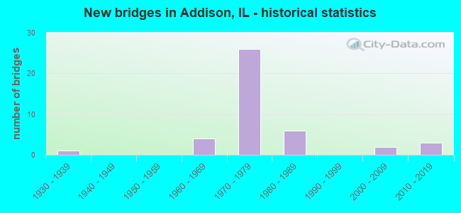
- New bridges - historical statistics
- 11930-1939
- 41960-1969
- 261970-1979
- 61980-1989
- 22000-2009
- 32010-2019
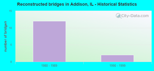
- Reconstructed bridges - Historical Statistics
- 121980-1989
- 21990-1999
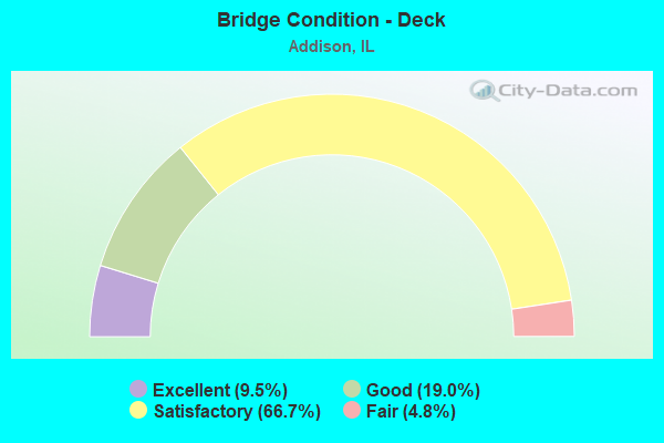
- Bridge Condition - Deck
- 9.5%Excellent
- 19.0%Good
- 66.7%Satisfactory
- 4.8%Fair
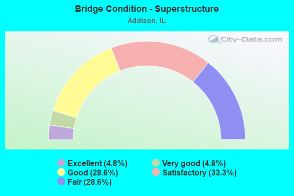
- Bridge Condition - Superstructure
- 4.8%Excellent
- 4.8%Very good
- 28.6%Good
- 33.3%Satisfactory
- 28.6%Fair
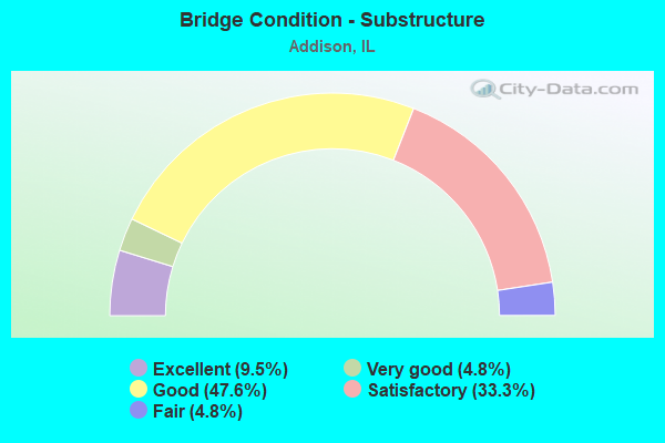
- Bridge Condition - Substructure
- 9.5%Excellent
- 4.8%Very good
- 47.6%Good
- 33.3%Satisfactory
- 4.8%Fair
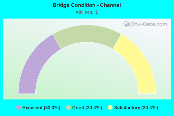
- Bridge Condition - Channel
- 33.3%Excellent
- 33.3%Good
- 33.3%Satisfactory
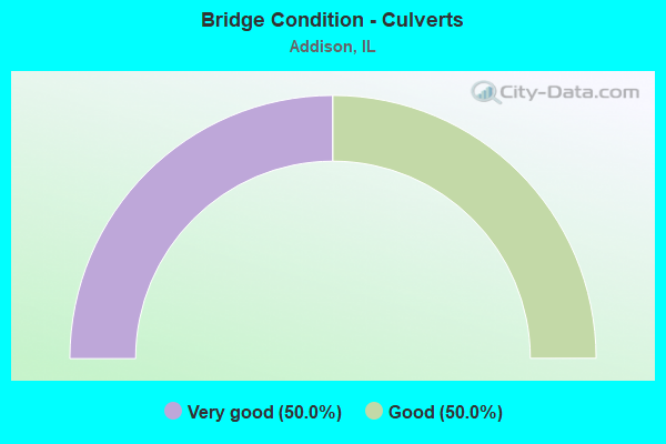
- Bridge Condition - Culverts
- 50.0%Very good
- 50.0%Good
Find on map >> Show street view
Structure Number: 220049, Location: 1.1 M E OF IL 53 (Lat: 41.945925, Lng: -88.021294), Route carried "on" structure: US 20, Year Built: 2006, Status: Open, Structure Length: 0.64m (2.10ft), Average Daily Traffic: 29,400 (year 2021), Truck Traffic: 2%, Average Future Daily Traffic: 32,417 (year 2032), Features Intersected: WESTWOOD CREEK
Minimum Vertical Clearance: 30+ m (98+ ft), Kilometerpoint: 256.844, Lanes on structure: 4, Base Highway Network: Yes, Owner: State Highway Agency, Approaching Roadway Width: 14.6m (47.9ft), Skew: 1 degrees, Material/Design: Concrete, Design/Construction: Culvert, Number Of Spans In Main Unit: 4, Length of Maximum Span: 3.0m (9.8ft), Curb-To-Curb Width: 19.5m (64.0ft), Out-to-Out Width: 32.5m (106.6ft)
Condition: Channel: Satisfactory, Culverts: Good, Operating Rating: 54.1 metric tons, Method Used To Determine Operating Rating: Load Factor (LF) rating reported by rating factor (RF) method using MS18 loading, Inventory Rating: 32.4 metric tons, Method Used To Determine Inventory Rating: Load Factor (LF) rating reported by rating factor (RF) method using MS18 loading, Structural Evaluation: Better than present minimum criteria, Deck Geometry: Better than present minimum criteria, Waterway Adequacy: Equal to present minimum criteria, Approach Roadway Alignment: Equal to present desirable criteria, Designated Inspection Frequency: Every 48 months, Inspection Date: Febuary 2020, Wearing Surface/Protective System: Deck Protection: Epoxy Coated Reinforcing
Find on map >> Show street view
Structure Number: 220075, Location: 0.9 M N OF IL 64 (Lat: 41.917733, Lng: -88.032319), Route carried "on" structure: State highway 53, Year Built: 1935, Year Reconstructed: 1985, Status: Open, Structure Length: 5.21m (17.09ft), Average Daily Traffic: 22,500 (year 2021), Truck Traffic: 14%, Average Future Daily Traffic: 24,174 (year 2032), Design Load: H 20, Features Intersected: RR - CN
Minimum Vertical Clearance: 30+ m (98+ ft), Kilometerpoint: 95.657, Lanes on structure: 4, Base Highway Network: Yes, Owner: State Highway Agency, Approaching Roadway Width: 19.5m (64.0ft), Skew: 2 degrees, Material/Design: Steel, Design/Construction: Stringer/Multi-beam, Number Of Spans In Main Unit: 3, Length of Maximum Span: 19.2m (63.0ft), Curb or Sidewalk Widths: Left: 1.5m (4.9ft), Right: 1.5m (4.9ft), Curb-To-Curb Width: 19.5m (64.0ft), Out-to-Out Width: 23.2m (76.1ft)
Condition: Deck: Satisfactory, Superstructure: Fair, Substructure: Fair, Operating Rating: 87.8 metric tons, Method Used To Determine Operating Rating: Load Factor (LF) rating reported by rating factor (RF) method using MS18 loading, Inventory Rating: 50.9 metric tons, Method Used To Determine Inventory Rating: Load Factor (LF) rating reported by rating factor (RF) method using MS18 loading, Structural Evaluation: Somewhat better than minimum adequacy, Deck Geometry: Better than present minimum criteria, Underclear: Somewhat better than minimum adequacy, Approach Roadway Alignment: Equal to present minimum criteria, Designated Inspection Frequency: Every 24 months, Inspection Date: August 2021, Deck Structure Type: Concrete Cast-file-Place, Wearing Surface/Protective System: Deck Protection: Epoxy Coated Reinforcing
Find on map >> Show street view
Structure Number: 220094, Location: 3.5 MI NW OF IL 83 (Lat: 41.958583, Lng: -88.025192), Route carried "on" structure: Other road , Year Built: 1970, Year Reconstructed: 1989, Status: Open, Structure Length: 35.58m (116.73ft), Average Daily Traffic: 22,400 (year 2021), Truck Traffic: 10%, Average Future Daily Traffic: 29,187 (year 2032), Design Load: HS 20, Features Intersected: I-290,355, Facility Carried by Structure: I-290 WB TO I-355
Minimum Vertical Clearance: 30+ m (98+ ft), Kilometerpoint: 0.531, Lanes on structure: 2, Lanes under structure: 14, Base Highway Network: Yes (Inventory Route: 10290040, Subroute: 40), Owner: State Highway Agency, Approaching Roadway Width: 11.9m (39.0ft), Skew: 4 degrees, Material/Design: Steel continuous, Design/Construction: Stringer/Multi-beam, Number Of Spans In Main Unit: 9, Number Of Approach Spans: 2, Length of Maximum Span: 61.0m (200.1ft), Curb-To-Curb Width: 11.9m (39.0ft), Out-to-Out Width: 13.2m (43.3ft)
Condition: Deck: Satisfactory, Superstructure: Fair, Substructure: Satisfactory, Operating Rating: 43.7 metric tons, Method Used To Determine Operating Rating: Load Factor (LF) rating reported by rating factor (RF) method using MS18 loading, Inventory Rating: 26.2 metric tons, Method Used To Determine Inventory Rating: Load Factor (LF) rating reported by rating factor (RF) method using MS18 loading, Structural Evaluation: Somewhat better than minimum adequacy, Deck Geometry: Equal to present minimum criteria, Underclear: Somewhat better than minimum adequacy, Approach Roadway Alignment: Equal to present desirable criteria, Designated Inspection Frequency: Every 24 months, Other Special Inspection Frequency: Every 24 months, Inspection Date: June 2021, Other Special Inspection Date: June 2021, Deck Structure Type: Concrete Cast-file-Place, Wearing Surface/Protective System: Wearing Surface: Latex Concrete
Find on map >> Show street view
Structure Number: 220095, Location: 1.3 M NW OF IL 83 (Lat: 41.942297, Lng: -87.988831), Route carried "on" structure: Interstate 290, Year Built: 1970, Year Reconstructed: 1985, Status: Open, Structure Length: 6.15m (20.18ft), Average Daily Traffic: 63,700 (year 2021), Truck Traffic: 10%, Average Future Daily Traffic: 86,781 (year 2032), Design Load: HS 20+Mod, Features Intersected: ADDISON RD
Minimum Vertical Clearance: 30+ m (98+ ft), Kilometerpoint: 14.612, Lanes on structure: 3, Lanes under structure: 4, Base Highway Network: Yes, Owner: State Highway Agency, Approaching Roadway Width: 17.7m (58.1ft), Skew: 3 degrees, Material/Design: Steel continuous, Design/Construction: Stringer/Multi-beam, Number Of Spans In Main Unit: 3, Length of Maximum Span: 29.3m (96.1ft), Curb-To-Curb Width: 17.7m (58.1ft), Out-to-Out Width: 18.5m (60.7ft)
Condition: Deck: Satisfactory, Superstructure: Satisfactory, Substructure: Satisfactory, Operating Rating: 59.6 metric tons, Method Used To Determine Operating Rating: Load Factor (LF) rating reported by rating factor (RF) method using MS18 loading, Inventory Rating: 35.6 metric tons, Method Used To Determine Inventory Rating: Load Factor (LF) rating reported by rating factor (RF) method using MS18 loading, Structural Evaluation: Equal to present minimum criteria, Deck Geometry: Better than present minimum criteria, Underclear: Equal to present minimum criteria, Approach Roadway Alignment: Equal to present desirable criteria, Designated Inspection Frequency: Every 24 months, Inspection Date: June 2021, Deck Structure Type: Concrete Cast-file-Place, Wearing Surface/Protective System: Wearing Surface: Other
Find on map >> Show street view
Structure Number: 220096, Location: 2.7 M NW OF IL 64 (Lat: 41.927572, Lng: -87.967028), Route carried "on" structure: Interstate 290, Year Built: 1971, Year Reconstructed: 1985, Status: Open, Structure Length: 9.00m (29.53ft), Average Daily Traffic: 58,850 (year 2021), Truck Traffic: 12%, Average Future Daily Traffic: 82,826 (year 2032), Design Load: HS 20+Mod, Features Intersected: IL 83
Minimum Vertical Clearance: 30+ m (98+ ft), Kilometerpoint: 17.171, Lanes on structure: 3, Lanes under structure: 6, Base Highway Network: Yes, Owner: State Highway Agency, Approaching Roadway Width: 20.7m (67.9ft), Material/Design: Steel continuous, Design/Construction: Stringer/Multi-beam, Number Of Spans In Main Unit: 3, Length of Maximum Span: 33.5m (109.9ft), Curb-To-Curb Width: 20.7m (67.9ft), Out-to-Out Width: 20.7m (67.9ft)
Condition: Deck: Satisfactory, Superstructure: Fair, Substructure: Satisfactory, Operating Rating: 68.0 metric tons, Method Used To Determine Operating Rating: Load Factor (LF) rating reported by rating factor (RF) method using MS18 loading, Inventory Rating: 38.9 metric tons, Method Used To Determine Inventory Rating: Load Factor (LF) rating reported by rating factor (RF) method using MS18 loading, Structural Evaluation: Somewhat better than minimum adequacy, Deck Geometry: Superior to present desirable criteria, Underclear: High priority of corrective action, Approach Roadway Alignment: Equal to present desirable criteria, Designated Inspection Frequency: Every 24 months, Inspection Date: August 2021, Deck Structure Type: Concrete Cast-file-Place, Wearing Surface/Protective System: Wearing Surface: Latex Concrete
Find on map >> Show street view
Structure Number: 220097, Location: 2.7 M NW OF IL 64 (Lat: 41.927556, Lng: -87.966872), Route carried "on" structure: Interstate 290, Year Built: 1971, Year Reconstructed: 1985, Status: Open, Structure Length: 9.00m (29.53ft), Average Daily Traffic: 58,850 (year 2021), Truck Traffic: 12%, Average Future Daily Traffic: 82,826 (year 2032), Design Load: HS 20+Mod, Features Intersected: IL 83
Minimum Vertical Clearance: 30+ m (98+ ft), Kilometerpoint: 17.187, Lanes on structure: 3, Lanes under structure: 6, Base Highway Network: Yes, Owner: State Highway Agency, Approaching Roadway Width: 20.7m (67.9ft), Material/Design: Steel continuous, Design/Construction: Stringer/Multi-beam, Number Of Spans In Main Unit: 3, Length of Maximum Span: 33.5m (109.9ft), Curb-To-Curb Width: 20.7m (67.9ft), Out-to-Out Width: 21.0m (68.9ft)
Condition: Deck: Satisfactory, Superstructure: Satisfactory, Substructure: Good, Operating Rating: 68.0 metric tons, Method Used To Determine Operating Rating: Load Factor (LF) rating reported by rating factor (RF) method using MS18 loading, Inventory Rating: 38.9 metric tons, Method Used To Determine Inventory Rating: Load Factor (LF) rating reported by rating factor (RF) method using MS18 loading, Structural Evaluation: Equal to present minimum criteria, Deck Geometry: Superior to present desirable criteria, Underclear: High priority of corrective action, Approach Roadway Alignment: Equal to present desirable criteria, Designated Inspection Frequency: Every 24 months, Inspection Date: August 2021, Deck Structure Type: Concrete Cast-file-Place, Wearing Surface/Protective System: Wearing Surface: Latex Concrete
Find on map >> Show street view
Structure Number: 2201, Location: 0.5 M NW OF IL 83 (Lat: 41.930961, Lng: -87.977231), Route carried "on" structure: Interstate 290, Year Built: 1971, Year Reconstructed: 1985, Status: Open, Structure Length: 5.89m (19.32ft), Average Daily Traffic: 63,700 (year 2021), Truck Traffic: 10%, Average Future Daily Traffic: 86,781 (year 2032), Design Load: HS 20+Mod, Features Intersected: WOODDALE RD
Minimum Vertical Clearance: 30+ m (98+ ft), Kilometerpoint: 16.238, Lanes on structure: 3, Lanes under structure: 4, Base Highway Network: Yes, Owner: State Highway Agency, Approaching Roadway Width: 17.7m (58.1ft), Skew: 1 degrees, Material/Design: Steel continuous, Design/Construction: Stringer/Multi-beam, Number Of Spans In Main Unit: 3, Length of Maximum Span: 29.3m (96.1ft), Curb-To-Curb Width: 17.7m (58.1ft), Out-to-Out Width: 18.5m (60.7ft)
Condition: Deck: Satisfactory, Superstructure: Fair, Substructure: Satisfactory, Operating Rating: 62.5 metric tons, Method Used To Determine Operating Rating: Load Factor (LF) rating reported by rating factor (RF) method using MS18 loading, Inventory Rating: 37.6 metric tons, Method Used To Determine Inventory Rating: Load Factor (LF) rating reported by rating factor (RF) method using MS18 loading, Structural Evaluation: Somewhat better than minimum adequacy, Deck Geometry: Better than present minimum criteria, Underclear: Somewhat better than minimum adequacy, Approach Roadway Alignment: Equal to present desirable criteria, Designated Inspection Frequency: Every 24 months, Other Special Inspection Frequency: Every 48 months, Inspection Date: September 2021, Other Special Inspection Date: September 2021, Deck Structure Type: Concrete Cast-file-Place, Wearing Surface/Protective System: Wearing Surface: Other, Deck Protection: Epoxy Coated Reinforcing
Find on map >> Show street view
Structure Number: 220104, Location: 1.3 M NW OF IL 83 (Lat: 41.942383, Lng: -87.988997), Route carried "on" structure: Interstate 290, Year Built: 1971, Year Reconstructed: 1985, Status: Open, Structure Length: 6.15m (20.18ft), Average Daily Traffic: 63,700 (year 2021), Truck Traffic: 10%, Average Future Daily Traffic: 86,781 (year 2032), Design Load: HS 20+Mod, Features Intersected: ADDISON RD
Minimum Vertical Clearance: 30+ m (98+ ft), Kilometerpoint: 14.596, Lanes on structure: 3, Lanes under structure: 4, Base Highway Network: Yes, Owner: State Highway Agency, Approaching Roadway Width: 18.3m (60.0ft), Skew: 3 degrees, Material/Design: Steel continuous, Design/Construction: Stringer/Multi-beam, Number Of Spans In Main Unit: 3, Length of Maximum Span: 29.3m (96.1ft), Curb-To-Curb Width: 18.3m (60.0ft), Out-to-Out Width: 18.5m (60.7ft)
Condition: Deck: Satisfactory, Superstructure: Satisfactory, Substructure: Satisfactory, Operating Rating: 58.6 metric tons, Method Used To Determine Operating Rating: Load Factor (LF) rating reported by rating factor (RF) method using MS18 loading, Inventory Rating: 35.3 metric tons, Method Used To Determine Inventory Rating: Load Factor (LF) rating reported by rating factor (RF) method using MS18 loading, Structural Evaluation: Equal to present minimum criteria, Deck Geometry: Better than present minimum criteria, Underclear: Equal to present minimum criteria, Approach Roadway Alignment: Equal to present desirable criteria, Designated Inspection Frequency: Every 24 months, Inspection Date: June 2021, Deck Structure Type: Concrete Cast-file-Place, Wearing Surface/Protective System: Wearing Surface: Other
Find on map >> Show street view
Structure Number: 220105, Location: 0.5 M NW OF IL 83 (Lat: 41.931058, Lng: -87.977372), Route carried "on" structure: Interstate 290, Year Built: 1971, Year Reconstructed: 1985, Status: Open, Structure Length: 5.73m (18.80ft), Average Daily Traffic: 63,700 (year 2021), Truck Traffic: 10%, Average Future Daily Traffic: 86,781 (year 2032), Design Load: HS 20+Mod, Features Intersected: WOODDALE RD
Minimum Vertical Clearance: 30+ m (98+ ft), Kilometerpoint: 16.222, Lanes on structure: 3, Lanes under structure: 4, Base Highway Network: Yes, Owner: State Highway Agency, Approaching Roadway Width: 17.7m (58.1ft), Skew: 1 degrees, Material/Design: Steel continuous, Design/Construction: Stringer/Multi-beam, Number Of Spans In Main Unit: 3, Length of Maximum Span: 29.3m (96.1ft), Curb-To-Curb Width: 17.7m (58.1ft), Out-to-Out Width: 18.5m (60.7ft)
Condition: Deck: Satisfactory, Superstructure: Fair, Substructure: Satisfactory, Operating Rating: 62.5 metric tons, Method Used To Determine Operating Rating: Load Factor (LF) rating reported by rating factor (RF) method using MS18 loading, Inventory Rating: 37.6 metric tons, Method Used To Determine Inventory Rating: Load Factor (LF) rating reported by rating factor (RF) method using MS18 loading, Structural Evaluation: Somewhat better than minimum adequacy, Deck Geometry: Better than present minimum criteria, Underclear: Somewhat better than minimum adequacy, Approach Roadway Alignment: Equal to present desirable criteria, Designated Inspection Frequency: Every 24 months, Other Special Inspection Frequency: Every 48 months, Inspection Date: September 2021, Other Special Inspection Date: September 2021, Deck Structure Type: Concrete Cast-file-Place, Wearing Surface/Protective System: Wearing Surface: Other
Find on map >> Show street view
Structure Number: 220109, Location: 2.6 M W IL 83 (Lat: 41.948736, Lng: -88.003322), Route carried "on" structure: Other road , Year Built: 1971, Status: Open, Structure Length: 8.96m (29.40ft), Average Daily Traffic: 2,350 (year 2020), Truck Traffic: 3%, Average Future Daily Traffic: 1,504 (year 2032), Design Load: HS 20, Features Intersected: I-290, Facility Carried by Structure: MILL RD
Minimum Vertical Clearance: 30+ m (98+ ft), Kilometerpoint: 2.012, Lanes on structure: 2, Lanes under structure: 6, Owner: State Highway Agency, Approaching Roadway Width: 12.2m (40.0ft), Skew: 3 degrees, Material/Design: Steel continuous, Design/Construction: Stringer/Multi-beam, Number Of Spans In Main Unit: 2, Number Of Approach Spans: 2, Length of Maximum Span: 32.0m (105.0ft), Curb or Sidewalk Widths: Left: 0.0m, Right: 1.7m (5.6ft), Curb-To-Curb Width: 10.8m (35.4ft), Out-to-Out Width: 14.0m (45.9ft)
Condition: Deck: Fair, Superstructure: Fair, Substructure: Good, Operating Rating: 63.2 metric tons, Method Used To Determine Operating Rating: Allowable Stress (AS) rating reported by rating factor (RF) method using MS18 loading, Inventory Rating: 34.3 metric tons, Method Used To Determine Inventory Rating: Allowable Stress (AS) rating reported by rating factor (RF) method using MS18 loading, Structural Evaluation: Somewhat better than minimum adequacy, Deck Geometry: Somewhat better than minimum adequacy, Underclear: Somewhat better than minimum adequacy, Approach Roadway Alignment: Equal to present desirable criteria, Designated Inspection Frequency: Every 24 months, Other Special Inspection Frequency: Every 72 months, Inspection Date: August 2021, Other Special Inspection Date: August 2021, Deck Structure Type: Concrete Cast-file-Place, Wearing Surface/Protective System: Wearing Surface: Other
Find on map >> Show street view
Structure Number: 220111, Location: 1.5 M S IL 19 (Lat: 41.951617, Lng: -88.034858), Route carried "on" structure: Interstate 355, Year Built: 1970, Year Reconstructed: 1988, Status: Open, Structure Length: 5.69m (18.67ft), Average Daily Traffic: 54,100 (year 2021), Truck Traffic: 13%, Average Future Daily Traffic: 77,590 (year 2032), Design Load: HS 20, Features Intersected: US 20
Minimum Vertical Clearance: 30+ m (98+ ft), Kilometerpoint: 50.468, Lanes on structure: 3, Lanes under structure: 6, Base Highway Network: Yes, Toll: On toll road, Owner: State Highway Agency, Approaching Roadway Width: 17.7m (58.1ft), Skew: 2 degrees, Material/Design: Steel continuous, Design/Construction: Stringer/Multi-beam, Number Of Spans In Main Unit: 3, Length of Maximum Span: 29.3m (96.1ft), Curb-To-Curb Width: 17.7m (58.1ft), Out-to-Out Width: 18.5m (60.7ft)
Condition: Deck: Good, Superstructure: Satisfactory, Substructure: Good, Operating Rating: 51.5 metric tons, Method Used To Determine Operating Rating: Load Factor (LF) rating reported by rating factor (RF) method using MS18 loading, Inventory Rating: 30.8 metric tons, Method Used To Determine Inventory Rating: Load Factor (LF) rating reported by rating factor (RF) method using MS18 loading, Structural Evaluation: Equal to present minimum criteria, Deck Geometry: Better than present minimum criteria, Underclear: High priority of corrective action, Approach Roadway Alignment: Better than present minimum criteria, Designated Inspection Frequency: Every 24 months, Other Special Inspection Frequency: Every 48 months, Inspection Date: November 2021, Other Special Inspection Date: January 2022, Deck Structure Type: Concrete Cast-file-Place, Wearing Surface/Protective System: Wearing Surface: Latex Concrete
Find on map >> Show street view
Structure Number: 220112, Location: 1.5 M S IL 19 (Lat: 41.951503, Lng: -88.034994), Route carried "on" structure: Interstate 355, Year Built: 1970, Year Reconstructed: 1988, Status: Open, Structure Length: 5.65m (18.54ft), Average Daily Traffic: 54,100 (year 2021), Truck Traffic: 13%, Average Future Daily Traffic: 77,590 (year 2032), Design Load: HS 20, Features Intersected: US 20
Minimum Vertical Clearance: 30+ m (98+ ft), Kilometerpoint: 50.452, Lanes on structure: 4, Lanes under structure: 6, Base Highway Network: Yes, Toll: On toll road, Owner: State Highway Agency, Approaching Roadway Width: 22.1m (72.5ft), Skew: 2 degrees, Material/Design: Steel continuous, Design/Construction: Stringer/Multi-beam, Number Of Spans In Main Unit: 3, Length of Maximum Span: 29.4m (96.5ft), Curb-To-Curb Width: 22.1m (72.5ft), Out-to-Out Width: 23.0m (75.5ft)
Condition: Deck: Satisfactory, Superstructure: Satisfactory, Substructure: Good, Operating Rating: 51.5 metric tons, Method Used To Determine Operating Rating: Load Factor (LF) rating reported by rating factor (RF) method using MS18 loading, Inventory Rating: 31.1 metric tons, Method Used To Determine Inventory Rating: Load Factor (LF) rating reported by rating factor (RF) method using MS18 loading, Structural Evaluation: Equal to present minimum criteria, Deck Geometry: Equal to present desirable criteria, Underclear: High priority of corrective action, Approach Roadway Alignment: Equal to present minimum criteria, Designated Inspection Frequency: Every 24 months, Other Special Inspection Frequency: Every 48 months, Inspection Date: November 2021, Other Special Inspection Date: January 2022, Deck Structure Type: Concrete Cast-file-Place, Wearing Surface/Protective System: Wearing Surface: Other
Find on map >> Show street view
Structure Number: 220119, Location: WOODDALE & US 20 (Lat: 41.928964, Lng: -87.977917), Route carried "on" structure: US 20, Year Built: 1969, Year Reconstructed: 1996, Status: Open, Structure Length: 3.72m (12.20ft), Average Daily Traffic: 29,700 (year 2021), Truck Traffic: 10%, Average Future Daily Traffic: 36,316 (year 2032), Design Load: HS 20, Features Intersected: SALT CREEK
Minimum Vertical Clearance: 30+ m (98+ ft), Kilometerpoint: 260.916, Lanes on structure: 6, Base Highway Network: Yes, Owner: State Highway Agency, Approaching Roadway Width: 36.0m (118.1ft), Skew: 35 degrees, Material/Design: Concrete continuous, Design/Construction: Slab, Number Of Spans In Main Unit: 3, Length of Maximum Span: 13.1m (43.0ft), Curb-To-Curb Width: 36.0m (118.1ft), Out-to-Out Width: 58.5m (191.9ft)
Condition: Deck: Satisfactory, Superstructure: Good, Substructure: Good, Channel: Satisfactory, Operating Rating: 74.2 metric tons, Method Used To Determine Operating Rating: Load Factor (LF) rating reported by rating factor (RF) method using MS18 loading, Inventory Rating: 44.7 metric tons, Method Used To Determine Inventory Rating: Load Factor (LF) rating reported by rating factor (RF) method using MS18 loading, Structural Evaluation: Better than present minimum criteria, Deck Geometry: Superior to present desirable criteria, Waterway Adequacy: Equal to present desirable criteria, Approach Roadway Alignment: Equal to present desirable criteria, Designated Inspection Frequency: Every 48 months, Inspection Date: January 2021, Deck Structure Type: Concrete Cast-file-Place, Wearing Surface/Protective System: Deck Protection: Epoxy Coated Reinforcing
Find on map >> Show street view
Structure Number: 22012, Location: 1.25 M N OF IL 64 (Lat: 41.924350, Lng: -87.967067), Route carried "on" structure: US 20, Year Built: 1969, Year Reconstructed: 2002, Status: Open, Structure Length: 10.43m (34.22ft), Average Daily Traffic: 29,700 (year 2021), Truck Traffic: 10%, Average Future Daily Traffic: 36,316 (year 2032), Design Load: HS 20, Features Intersected: IL 83
Minimum Vertical Clearance: 30+ m (98+ ft), Kilometerpoint: 261.946, Lanes on structure: 4, Lanes under structure: 7, Base Highway Network: Yes, Owner: State Highway Agency, Approaching Roadway Width: 25.6m (84.0ft), Skew: 33 degrees, Material/Design: Steel continuous, Design/Construction: Stringer/Multi-beam, Number Of Spans In Main Unit: 3, Length of Maximum Span: 39.0m (128.0ft), Curb or Sidewalk Widths: Left: 2.1m (6.9ft), Right: 2.1m (6.9ft), Curb-To-Curb Width: 25.6m (84.0ft), Out-to-Out Width: 30.5m (100.1ft)
Condition: Deck: Good, Superstructure: Good, Substructure: Good, Operating Rating: 73.5 metric tons, Method Used To Determine Operating Rating: Load Factor (LF) rating reported by rating factor (RF) method using MS18 loading, Inventory Rating: 44.1 metric tons, Method Used To Determine Inventory Rating: Load Factor (LF) rating reported by rating factor (RF) method using MS18 loading, Structural Evaluation: Better than present minimum criteria, Deck Geometry: Superior to present desirable criteria, Underclear: High priority of corrective action, Approach Roadway Alignment: Equal to present desirable criteria, Designated Inspection Frequency: Every 24 months, Inspection Date: December 2021, Deck Structure Type: Concrete Cast-file-Place, Wearing Surface/Protective System: Deck Protection: Epoxy Coated Reinforcing
Find on map >> Show street view
Structure Number: 220137, Location: 0.5 M N IL53 & US 20 (Lat: 41.953811, Lng: -88.031731), Route carried "on" structure: Interstate 355, Year Built: 1970, Year Reconstructed: 1989, Status: Open, Structure Length: 7.77m (25.49ft), Average Daily Traffic: 54,100 (year 2021), Truck Traffic: 13%, Average Future Daily Traffic: 77,590 (year 2032), Design Load: HS 20, Features Intersected: ROHLWING RD
Minimum Vertical Clearance: 30+ m (98+ ft), Kilometerpoint: 50.806, Lanes on structure: 5, Lanes under structure: 2, Base Highway Network: Yes, Toll: On toll road, Owner: State Highway Agency, Approaching Roadway Width: 27.3m (89.6ft), Skew: 4 degrees, Material/Design: Steel continuous, Design/Construction: Stringer/Multi-beam, Number Of Spans In Main Unit: 3, Length of Maximum Span: 40.7m (133.5ft), Curb-To-Curb Width: 25.6m (84.0ft), Out-to-Out Width: 28.3m (92.8ft)
Condition: Deck: Satisfactory, Superstructure: Satisfactory, Substructure: Satisfactory, Operating Rating: 49.2 metric tons, Method Used To Determine Operating Rating: Load Factor (LF) rating reported by rating factor (RF) method using MS18 loading, Inventory Rating: 29.5 metric tons, Method Used To Determine Inventory Rating: Load Factor (LF) rating reported by rating factor (RF) method using MS18 loading, Structural Evaluation: Equal to present minimum criteria, Deck Geometry: Better than present minimum criteria, Underclear: High priority of corrective action, Approach Roadway Alignment: Better than present minimum criteria, Designated Inspection Frequency: Every 24 months, Other Special Inspection Frequency: Every 48 months, Inspection Date: September 2021, Other Special Inspection Date: August 2018, Deck Structure Type: Concrete Cast-file-Place, Wearing Surface/Protective System: Wearing Surface: Latex Concrete
Find on map >> Show street view
Structure Number: 220138, Location: 0.5 M N IL 53 & US20 (Lat: 41.953889, Lng: -88.031617), Route carried "on" structure: Interstate 355, Year Built: 1970, Year Reconstructed: 1988, Status: Open, Structure Length: 7.99m (26.21ft), Average Daily Traffic: 54,100 (year 2021), Truck Traffic: 13%, Average Future Daily Traffic: 77,590 (year 2032), Design Load: HS 20, Features Intersected: ROHLWING RD
Minimum Vertical Clearance: 30+ m (98+ ft), Kilometerpoint: 50.822, Lanes on structure: 6, Lanes under structure: 2, Base Highway Network: Yes, Toll: On toll road, Owner: State Highway Agency, Approaching Roadway Width: 32.9m (107.9ft), Skew: 14 degrees, Material/Design: Steel continuous, Design/Construction: Stringer/Multi-beam, Number Of Spans In Main Unit: 3, Length of Maximum Span: 40.7m (133.5ft), Curb-To-Curb Width: 32.9m (107.9ft), Out-to-Out Width: 33.8m (110.9ft)
Condition: Deck: Satisfactory, Superstructure: Satisfactory, Substructure: Good, Operating Rating: 48.6 metric tons, Method Used To Determine Operating Rating: Load Factor (LF) rating reported by rating factor (RF) method using MS18 loading, Inventory Rating: 29.2 metric tons, Method Used To Determine Inventory Rating: Load Factor (LF) rating reported by rating factor (RF) method using MS18 loading, Structural Evaluation: Equal to present minimum criteria, Deck Geometry: Superior to present desirable criteria, Underclear: High priority of corrective action, Approach Roadway Alignment: Equal to present desirable criteria, Designated Inspection Frequency: Every 24 months, Other Special Inspection Frequency: Every 48 months, Inspection Date: September 2021, Other Special Inspection Date: August 2018, Deck Structure Type: Concrete Cast-file-Place, Wearing Surface/Protective System: Wearing Surface: Other
Find on map >> Show street view
Structure Number: 220175, Location: 0.60 M NW ADDISON RD (Lat: 41.936442, Lng: -87.998572), Route carried "on" structure: US 20, Year Built: 2006, Status: Open, Structure Length: 1.14m (3.74ft), Average Daily Traffic: 27,800 (year 2021), Truck Traffic: 4%, Average Future Daily Traffic: 29,967 (year 2032), Features Intersected: WESTWOOD CREEK
Minimum Vertical Clearance: 30+ m (98+ ft), Kilometerpoint: 259.001, Lanes on structure: 4, Base Highway Network: Yes, Owner: State Highway Agency, Approaching Roadway Width: 15.2m (49.9ft), Skew: 3 degrees, Material/Design: Concrete continuous, Design/Construction: Culvert, Number Of Spans In Main Unit: 3, Length of Maximum Span: 3.3m (10.8ft)
Condition: Channel: Good, Culverts: Very good, Operating Rating: 88.1 metric tons, Method Used To Determine Operating Rating: Load Factor (LF) rating reported by rating factor (RF) method using MS18 loading, Inventory Rating: 52.8 metric tons, Method Used To Determine Inventory Rating: Load Factor (LF) rating reported by rating factor (RF) method using MS18 loading, Structural Evaluation: Equal to present desirable criteria, Waterway Adequacy: Equal to present desirable criteria, Approach Roadway Alignment: Somewhat better than minimum adequacy, Designated Inspection Frequency: Every 48 months, Inspection Date: March 2020, Wearing Surface/Protective System: Deck Protection: Epoxy Coated Reinforcing
Find on map >> Show street view
Structure Number: 220547, Location: 0.6 M NW OF IL 83 (Lat: 41.939925, Lng: -87.985261), Route carried "on" structure: Interstate 290, Year Built: 2019, Status: Open, Structure Length: 6.35m (20.83ft), Average Daily Traffic: 63,700 (year 2021), Truck Traffic: 10%, Average Future Daily Traffic: 80,640 (year 2038), Design Load: HS 25 or greater, Features Intersected: SALT CREEK
Minimum Vertical Clearance: 30+ m (98+ ft), Kilometerpoint: 15.015, Lanes on structure: 3, Base Highway Network: Yes, Owner: State Highway Agency, Approaching Roadway Width: 18.3m (60.0ft), Skew: 2 degrees, Material/Design: Prestressed concrete continuous, Design/Construction: Stringer/Multi-beam, Number Of Spans In Main Unit: 3, Length of Maximum Span: 27.4m (89.9ft), Curb-To-Curb Width: 18.8m (61.7ft), Out-to-Out Width: 19.8m (65.0ft)
Condition: Deck: Excellent, Superstructure: Very good, Substructure: Excellent, Channel: Excellent, Operating Rating: 63.2 metric tons, Method Used To Determine Operating Rating: Load and Resistance Factor Rating (LRFR) rating reported by rating factor(RF) method using HL-93 loadings, Inventory Rating: 48.9 metric tons, Method Used To Determine Inventory Rating: Load and Resistance Factor Rating (LRFR) rating reported by rating factor(RF) method using HL-93 loadings, Structural Evaluation: Equal to present desirable criteria, Deck Geometry: Superior to present desirable criteria, Waterway Adequacy: Superior to present desirable criteria, Approach Roadway Alignment: Equal to present desirable criteria, Designated Inspection Frequency: Every 24 months, Inspection Date: Febuary 2020, Deck Structure Type: Concrete Cast-file-Place, Wearing Surface/Protective System: Deck Protection: Epoxy Coated Reinforcing
Find on map >> Show street view
Structure Number: 220577, Location: 0.6 M NW OF IL 83 (Lat: 41.939925, Lng: -87.985261), Route carried "on" structure: Interstate 290, Year Built: 2018, Status: Open, Structure Length: 6.35m (20.83ft), Average Daily Traffic: 63,700 (year 2021), Truck Traffic: 10%, Average Future Daily Traffic: 74,000 (year 2038), Design Load: HS 25 or greater, Features Intersected: SALT CREEK
Minimum Vertical Clearance: 30+ m (98+ ft), Kilometerpoint: 15.015, Lanes on structure: 3, Base Highway Network: Yes, Owner: State Highway Agency, Approaching Roadway Width: 18.3m (60.0ft), Skew: 2 degrees, Material/Design: Prestressed concrete continuous, Design/Construction: Stringer/Multi-beam, Number Of Spans In Main Unit: 3, Length of Maximum Span: 26.2m (86.0ft), Curb-To-Curb Width: 18.8m (61.7ft), Out-to-Out Width: 19.6m (64.3ft)
Condition: Deck: Excellent, Superstructure: Excellent, Substructure: Excellent, Channel: Good, Operating Rating: 66.4 metric tons, Method Used To Determine Operating Rating: Load and Resistance Factor Rating (LRFR) rating reported by rating factor(RF) method using HL-93 loadings, Inventory Rating: 51.2 metric tons, Method Used To Determine Inventory Rating: Load and Resistance Factor Rating (LRFR) rating reported by rating factor(RF) method using HL-93 loadings, Structural Evaluation: Superior to present desirable criteria, Deck Geometry: Superior to present desirable criteria, Waterway Adequacy: Superior to present desirable criteria, Approach Roadway Alignment: Equal to present desirable criteria, Designated Inspection Frequency: Every 24 months, Inspection Date: October 2020, Deck Structure Type: Concrete Cast-file-Place, Wearing Surface/Protective System: Deck Protection: Epoxy Coated Reinforcing
Find on map >> Show street view
Structure Number: 223041, Location: 0.5 MI W IL 83 (Lat: 41.920200, Lng: -87.973294), Route carried "on" structure: County highway , Year Built: 2013, Status: Open, Structure Length: 4.66m (15.29ft), Average Daily Traffic: 950 (year 2020), Truck Traffic: 4%, Average Future Daily Traffic: 450 (year 2032), Design Load: HS 25 or greater, Features Intersected: SALT CREEK, Facility Carried by Structure: FULLERTON AVE
Minimum Vertical Clearance: 30+ m (98+ ft), Kilometerpoint: 0.113, Lanes on structure: 2, Owner: Town or Township Highway Agency, Approaching Roadway Width: 9.8m (32.2ft), Skew: 2 degrees, Material/Design: Prestressed concrete, Design/Construction: Box Beam or Girders - Multiple, Number Of Spans In Main Unit: 3, Length of Maximum Span: 15.3m (50.2ft), Curb or Sidewalk Widths: Left: 1.5m (4.9ft), Right: 1.5m (4.9ft), Curb-To-Curb Width: 9.8m (32.2ft), Out-to-Out Width: 13.4m (44.0ft)
Condition: Deck: Good, Superstructure: Good, Substructure: Very good, Channel: Excellent, Operating Rating: 42.1 metric tons, Method Used To Determine Operating Rating: Assigned ratings based on Load and Resistance Factor Design (LRFD) reported by rating factor (RF) using HL93 loadings, Inventory Rating: 32.4 metric tons, Method Used To Determine Inventory Rating: Assigned ratings based on Load and Resistance Factor Design (LRFD) reported by rating factor (RF) using HL93 loadings, Structural Evaluation: Better than present minimum criteria, Deck Geometry: Equal to present minimum criteria, Waterway Adequacy: Superior to present desirable criteria, Approach Roadway Alignment: Equal to present desirable criteria, Designated Inspection Frequency: Every 48 months, Inspection Date: June 2018, Deck Structure Type: Concrete Precast Panels, Wearing Surface/Protective System: Wearing Surface: Integral Concrete, Deck Protection: Epoxy Coated Reinforcing
Find on map >> Show street view
Structure Number: 229952, Location: 0.3M.W.OF IL-53 (Lat: 41.932511, Lng: -88.037825), Route carried "on" structure: Interstate 355, Year Built: 1989, Status: Open, Structure Length: 6.58m (21.59ft), Average Daily Traffic: 54,100 (year 2021), Truck Traffic: 13%, Average Future Daily Traffic: 77,590 (year 2032), Features Intersected: ARMY TRAIL RD.
Minimum Vertical Clearance: 30+ m (98+ ft), Kilometerpoint: 48.263, Lanes on structure: 3, Lanes under structure: 6, Base Highway Network: Yes, Toll: On toll road, Owner: State Toll Authority, Approaching Roadway Width: 21.0m (68.9ft), Material/Design: Prestressed concrete, Design/Construction: Stringer/Multi-beam, Number Of Spans In Main Unit: 2, Length of Maximum Span: 32.9m (107.9ft), Curb-To-Curb Width: 21.0m (68.9ft), Out-to-Out Width: 22.3m (73.2ft)
Condition: Deck: Satisfactory, Superstructure: Good, Substructure: Good, Operating Rating: 59.0 metric tons, Method Used To Determine Operating Rating: Load Factor (LF) rating reported by rating factor (RF) method using MS18 loading, Inventory Rating: 35.3 metric tons, Method Used To Determine Inventory Rating: Load Factor (LF) rating reported by rating factor (RF) method using MS18 loading, Structural Evaluation: Better than present minimum criteria, Deck Geometry: Superior to present desirable criteria, Underclear: Meets minimum limits, Approach Roadway Alignment: Equal to present desirable criteria, Designated Inspection Frequency: Every 24 months, Inspection Date: September 2020, Deck Structure Type: Concrete Cast-file-Place
Find on map >> Show street view
Structure Number: 229953, Location: 0.3M.W.OF IL-53 (Lat: 41.918992, Lng: -88.037992), Route carried "on" structure: Interstate 355, Year Built: 1989, Status: Open, Structure Length: 6.34m (20.80ft), Average Daily Traffic: 84,400 (year 2020), Truck Traffic: 13%, Average Future Daily Traffic: 131,229 (year 2032), Features Intersected: FULLERTON & CC&P RR
Minimum Vertical Clearance: 30+ m (98+ ft), Kilometerpoint: 46.750, Lanes on structure: 6, Lanes under structure: 2, Base Highway Network: Yes, Toll: On toll road, Owner: State Toll Authority, Approaching Roadway Width: 37.5m (123.0ft), Skew: 32 degrees, Material/Design: Prestressed concrete, Design/Construction: Stringer/Multi-beam, Number Of Spans In Main Unit: 4, Length of Maximum Span: 22.3m (73.2ft), Curb-To-Curb Width: 36.6m (120.1ft), Out-to-Out Width: 39.0m (128.0ft)
Condition: Deck: Satisfactory, Superstructure: Good, Substructure: Good, Operating Rating: 71.6 metric tons, Method Used To Determine Operating Rating: Load Factor (LF) rating reported by rating factor (RF) method using MS18 loading, Inventory Rating: 42.8 metric tons, Method Used To Determine Inventory Rating: Load Factor (LF) rating reported by rating factor (RF) method using MS18 loading, Structural Evaluation: Better than present minimum criteria, Deck Geometry: Superior to present desirable criteria, Underclear: Equal to present minimum criteria, Approach Roadway Alignment: Equal to present desirable criteria, Designated Inspection Frequency: Every 24 months, Inspection Date: September 2020, Deck Structure Type: Concrete Cast-file-Place
Find on map >> Show street view
Structure Number: 229956, Location: 0.3M.W.OF IL-53 (Lat: 41.932417, Lng: -88.037825), Route carried "on" structure: Interstate 355, Year Built: 1989, Status: Open, Structure Length: 6.58m (21.59ft), Average Daily Traffic: 54,100 (year 2021), Truck Traffic: 13%, Average Future Daily Traffic: 65,615 (year 2032), Features Intersected: ARMY TRAIL RD.
Minimum Vertical Clearance: 30+ m (98+ ft), Kilometerpoint: 48.247, Lanes on structure: 3, Lanes under structure: 6, Base Highway Network: Yes, Toll: On toll road, Owner: State Toll Authority, Approaching Roadway Width: 21.0m (68.9ft), Material/Design: Prestressed concrete, Design/Construction: Stringer/Multi-beam, Number Of Spans In Main Unit: 2, Length of Maximum Span: 32.9m (107.9ft), Curb-To-Curb Width: 21.0m (68.9ft), Out-to-Out Width: 22.3m (73.2ft)
Condition: Deck: Good, Superstructure: Good, Substructure: Good, Operating Rating: 59.0 metric tons, Method Used To Determine Operating Rating: Load Factor (LF) rating reported by rating factor (RF) method using MS18 loading, Inventory Rating: 35.3 metric tons, Method Used To Determine Inventory Rating: Load Factor (LF) rating reported by rating factor (RF) method using MS18 loading, Structural Evaluation: Better than present minimum criteria, Deck Geometry: Superior to present desirable criteria, Underclear: Meets minimum limits, Approach Roadway Alignment: Equal to present desirable criteria, Designated Inspection Frequency: Every 24 months, Inspection Date: September 2020, Deck Structure Type: Concrete Cast-file-Place
Find on map >> Show street view
Structure Number: 220094, Location: 3.5 MI NW OF IL 83 (Lat: 41.957567, Lng: -88.027475), Route carried "under" structure: Interstate 355, Year Built: 1970, Structure Length: 0. m, Average Daily Traffic: 108,200 (year 2021), Truck Traffic: 13%, Features Intersected: I-290,355
Minimum Vertical Clearance: 5.00m (16.40ft), Kilometerpoint: 51.449, Lanes on structure: 2, Lanes under structure: 10, Material/Design: Steel continuous, Design/Construction: Stringer/Multi-beam, Length of Maximum Span: 61.0m (200.1ft)
Find on map >> Show street view
Structure Number: 220094, Location: 3.5 MI NW OF IL 83 (Lat: 41.958583, Lng: -88.025192), Route carried "under" structure: Interstate 290, Year Built: 1970, Structure Length: 0. m, Average Daily Traffic: 81,200 (year 2021), Truck Traffic: 24%, Features Intersected: I-290,355
Minimum Vertical Clearance: 5.00m (16.40ft), Kilometerpoint: 11.169, Lanes on structure: 2, Lanes under structure: 4, Material/Design: Steel continuous, Design/Construction: Stringer/Multi-beam, Length of Maximum Span: 61.0m (200.1ft)
Find on map >> Show street view
Structure Number: 220095, Location: 1.3 M NW OF IL 83 (Lat: 41.942792, Lng: -87.988661), Route carried "under" structure: Other road , Year Built: 1970, Structure Length: 0. m, Average Daily Traffic: 10,000 (year 2020), Truck Traffic: 5%, Features Intersected: ADDISON RD, Facility Carried by Structure: I-290 WB
Minimum Vertical Clearance: 5.18m (16.99ft), Kilometerpoint: 2.527, Lanes on structure: 3, Lanes under structure: 4, Material/Design: Steel continuous, Design/Construction: Stringer/Multi-beam, Length of Maximum Span: 29.3m (96.1ft)
Find on map >> Show street view
Structure Number: 220096, Location: 2.7 M NW OF IL 64 (Lat: 41.927469, Lng: -87.967025), Route carried "under" structure: Other road , Year Built: 1971, Structure Length: 0. m, Average Daily Traffic: 11,700 (year 2020), Truck Traffic: 23%, Features Intersected: IL 83, Facility Carried by Structure: I-290 EB
Minimum Vertical Clearance: 4.50m (14.76ft), Kilometerpoint: 0.740, Lanes on structure: 3, Lanes under structure: 1, Material/Design: Steel continuous, Design/Construction: Stringer/Multi-beam, Length of Maximum Span: 33.5m (109.9ft)
Find on map >> Show street view
Structure Number: 220096, Location: 2.7 M NW OF IL 64 (Lat: 41.927428, Lng: -87.966869), Route carried "under" structure: State highway 83, Year Built: 1971, Structure Length: 0. m, Average Daily Traffic: 49,200 (year 2021), Truck Traffic: 16%, Features Intersected: IL 83, Facility Carried by Structure: I-290 EB
Minimum Vertical Clearance: 4.65m (15.26ft), Kilometerpoint: 77.166, Lanes on structure: 3, Lanes under structure: 4, Material/Design: Steel continuous, Design/Construction: Stringer/Multi-beam, Length of Maximum Span: 33.5m (109.9ft)
Find on map >> Show street view
Structure Number: 220097, Location: 2.7 M NW OF IL 64 (Lat: 41.927800, Lng: -87.966881), Route carried "under" structure: State highway 83, Year Built: 1971, Structure Length: 0. m, Average Daily Traffic: 49,200 (year 2021), Truck Traffic: 16%, Features Intersected: IL 83, Facility Carried by Structure: I-290 WB
Minimum Vertical Clearance: 4.57m (14.99ft), Kilometerpoint: 77.198, Lanes on structure: 3, Lanes under structure: 4, Material/Design: Steel continuous, Design/Construction: Stringer/Multi-beam, Length of Maximum Span: 33.5m (109.9ft)
Find on map >> Show street view
Structure Number: 220097, Location: 2.7 M NW OF IL 64 (Lat: 41.927817, Lng: -87.967036), Route carried "under" structure: Other road , Year Built: 1971, Structure Length: 0. m, Average Daily Traffic: 11,700 (year 2020), Truck Traffic: 23%, Features Intersected: IL 83, Facility Carried by Structure: I-290 WB
Minimum Vertical Clearance: 4.57m (14.99ft), Kilometerpoint: 0.708, Lanes on structure: 3, Lanes under structure: 1, Material/Design: Steel continuous, Design/Construction: Stringer/Multi-beam, Length of Maximum Span: 33.5m (109.9ft)
Find on map >> Show street view
Structure Number: 2201, Location: 0.5 M NW OF IL 83 (Lat: 41.931756, Lng: -87.976592), Route carried "under" structure: Other road , Year Built: 1971, Structure Length: 0. m, Average Daily Traffic: 7,400 (year 2020), Truck Traffic: 3%, Features Intersected: WOODDALE RD, Facility Carried by Structure: I-290 WB
Minimum Vertical Clearance: 4.57m (14.99ft), Kilometerpoint: 6.984, Lanes on structure: 3, Lanes under structure: 4, Material/Design: Steel continuous, Design/Construction: Stringer/Multi-beam, Length of Maximum Span: 29.3m (96.1ft)
Find on map >> Show street view
Structure Number: 220104, Location: 1.3 M NW OF IL 83 (Lat: 41.942122, Lng: -87.988661), Route carried "under" structure: Other road , Year Built: 1971, Structure Length: 0. m, Average Daily Traffic: 10,500 (year 2020), Truck Traffic: 6%, Features Intersected: ADDISON RD, Facility Carried by Structure: I-290 EB
Minimum Vertical Clearance: 5.46m (17.91ft), Kilometerpoint: 2.575, Lanes on structure: 3, Lanes under structure: 4, Material/Design: Steel continuous, Design/Construction: Stringer/Multi-beam, Length of Maximum Span: 29.3m (96.1ft)
Find on map >> Show street view
Structure Number: 220105, Location: 0.5 M NW OF IL 83 (Lat: 41.930800, Lng: -87.977131), Route carried "under" structure: Other road , Year Built: 1971, Structure Length: 0. m, Average Daily Traffic: 7,400 (year 2020), Truck Traffic: 3%, Features Intersected: WOODDALE RD, Facility Carried by Structure: I-290 EB
Minimum Vertical Clearance: 4.93m (16.17ft), Kilometerpoint: 7.081, Lanes on structure: 3, Lanes under structure: 4, Material/Design: Steel continuous, Design/Construction: Stringer/Multi-beam, Length of Maximum Span: 29.3m (96.1ft)
Find on map >> Show street view
Structure Number: 220109, Location: 2.6 M W IL 83 (Lat: 41.948736, Lng: -88.003322), Route carried "under" structure: Interstate 290, Year Built: 1971, Structure Length: 0. m, Average Daily Traffic: 127,400 (year 2021), Truck Traffic: 10%, Features Intersected: I-290, Facility Carried by Structure: MILL RD
Minimum Vertical Clearance: 5.18m (16.99ft), Kilometerpoint: 13.277, Lanes on structure: 2, Lanes under structure: 6, Material/Design: Steel continuous, Design/Construction: Stringer/Multi-beam, Length of Maximum Span: 32.0m (105.0ft)
Find on map >> Show street view
Structure Number: 220111, Location: 1.5 M S IL 19 (Lat: 41.951503, Lng: -88.034994), Route carried "under" structure: US 20, Year Built: 1970, Structure Length: 0. m, Average Daily Traffic: 32,600 (year 2021), Truck Traffic: 5%, Features Intersected: US 20, Facility Carried by Structure: I-355 SB
Minimum Vertical Clearance: 4.57m (14.99ft), Kilometerpoint: 255.509, Lanes on structure: 3, Lanes under structure: 6, Toll: On toll road, Material/Design: Steel continuous, Design/Construction: Stringer/Multi-beam, Length of Maximum Span: 29.3m (96.1ft)
Find on map >> Show street view
Structure Number: 220112, Location: 1.5 M S IL 19 (Lat: 41.951369, Lng: -88.034664), Route carried "under" structure: US 20, Year Built: 1970, Structure Length: 0. m, Average Daily Traffic: 32,600 (year 2021), Truck Traffic: 5%, Features Intersected: US 20, Facility Carried by Structure: I-355 NB
Minimum Vertical Clearance: 4.62m (15.16ft), Kilometerpoint: 255.541, Lanes on structure: 4, Lanes under structure: 6, Toll: On toll road, Material/Design: Steel continuous, Design/Construction: Stringer/Multi-beam, Length of Maximum Span: 29.4m (96.5ft)
Find on map >> Show street view
Structure Number: 22012, Location: 1.25 M N OF IL 64 (Lat: 41.924208, Lng: -87.966747), Route carried "under" structure: State highway 83, Year Built: 1969, Structure Length: 0. m, Average Daily Traffic: 46,600 (year 2021), Truck Traffic: 8%, Features Intersected: IL 83, Facility Carried by Structure: US 20
Minimum Vertical Clearance: 4.95m (16.24ft), Kilometerpoint: 76.796, Lanes on structure: 4, Lanes under structure: 4, Material/Design: Steel continuous, Design/Construction: Stringer/Multi-beam, Length of Maximum Span: 39.0m (128.0ft)
Find on map >> Show street view
Structure Number: 22012, Location: 1.25 M N OF IL 64 (Lat: 41.924278, Lng: -87.966908), Route carried "under" structure: Other road , Year Built: 1969, Structure Length: 0. m, Average Daily Traffic: 11,700 (year 2020), Truck Traffic: 23%, Features Intersected: IL 83, Facility Carried by Structure: US 20
Minimum Vertical Clearance: 4.72m (15.49ft), Kilometerpoint: 1.110, Lanes on structure: 4, Lanes under structure: 1, Material/Design: Steel continuous, Design/Construction: Stringer/Multi-beam, Length of Maximum Span: 39.0m (128.0ft)
Find on map >> Show street view
Structure Number: 220137, Location: 0.5 M N IL53 & US 20 (Lat: 41.953811, Lng: -88.031731), Route carried "under" structure: State highway 53, Year Built: 1970, Structure Length: 0. m, Average Daily Traffic: 15,100 (year 2021), Truck Traffic: 8%, Features Intersected: ROHLWING RD, Facility Carried by Structure: I-355 NB
Minimum Vertical Clearance: 4.52m (14.83ft), Kilometerpoint: 99.616, Lanes on structure: 5, Lanes under structure: 2, Toll: On toll road, Material/Design: Steel continuous, Design/Construction: Stringer/Multi-beam, Length of Maximum Span: 40.7m (133.5ft)
Find on map >> Show street view
Structure Number: 229952, Location: 0.3M.W.OF IL-53 (Lat: 41.932131, Lng: -88.037325), Route carried "under" structure: Other road , Year Built: 1989, Structure Length: 0. m, Average Daily Traffic: 33,200 (year 2020), Truck Traffic: 9%, Features Intersected: ARMY TRAIL RD., Facility Carried by Structure: I-355 NB
Minimum Vertical Clearance: 5.05m (16.57ft), Kilometerpoint: 14.339, Lanes on structure: 3, Lanes under structure: 6, Toll: On toll road, Material/Design: Prestressed concrete, Design/Construction: Stringer/Multi-beam, Length of Maximum Span: 32.9m (107.9ft)
Find on map >> Show street view
Structure Number: 229953, Location: 0.3M.W.OF IL-53 (Lat: 41.918992, Lng: -88.037992), Route carried "under" structure: Other road , Year Built: 1989, Structure Length: 0. m, Average Daily Traffic: 11,600 (year 2020), Truck Traffic: 24%, Features Intersected: FULLERTON & CC&P RR, Facility Carried by Structure: I-355
Minimum Vertical Clearance: 30+ m (98+ ft), Kilometerpoint: 0.386, Lanes on structure: 6, Lanes under structure: 2, Toll: On toll road, Material/Design: Prestressed concrete, Design/Construction: Stringer/Multi-beam, Length of Maximum Span: 22.3m (73.2ft)
Find on map >> Show street view
Structure Number: 229956, Location: 0.3M.W.OF IL-53 (Lat: 41.932183, Lng: -88.037825), Route carried "under" structure: Other road , Year Built: 1989, Structure Length: 0. m, Average Daily Traffic: 33,200 (year 2020), Truck Traffic: 9%, Features Intersected: ARMY TRAIL RD., Facility Carried by Structure: I-355 SB
Minimum Vertical Clearance: 5.05m (16.57ft), Kilometerpoint: 14.307, Lanes on structure: 3, Lanes under structure: 6, Toll: On toll road, Material/Design: Prestressed concrete, Design/Construction: Stringer/Multi-beam, Length of Maximum Span: 32.9m (107.9ft)