Bridge Statistics for Alderson, West Virginia (WV)
Condition, Traffic, Stress, Structural Evaluation, Project Costs
- National Bridge Inventory (NBI) Statistics
- 10Number of bridges
- 144ft / 44.1mTotal length
- $1,942,000Total costs
- 4,467Total average daily traffic
- 251Total average daily truck traffic
- 6,315Total future (year 2037) average daily traffic
- National Bridge Inventory (NBI) Registered Bridges for Alderson
- No street view available for this location
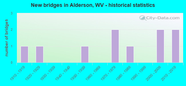
- New bridges - historical statistics
- 11910-1919
- 11920-1929
- 11950-1959
- 21970-1979
- 11980-1989
- 22000-2009
- 22010-2019
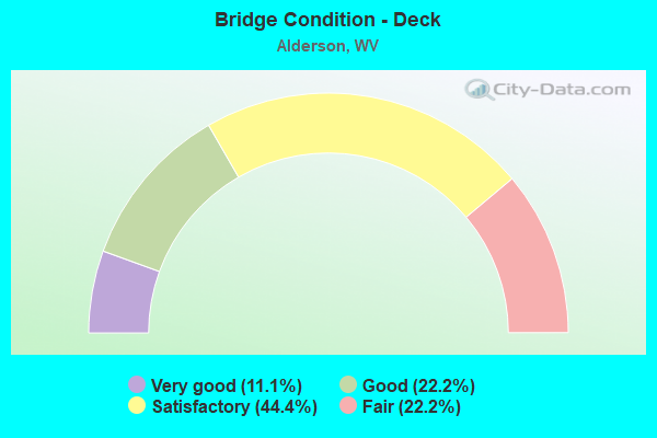
- Bridge Condition - Deck
- 11.1%Very good
- 22.2%Good
- 44.4%Satisfactory
- 22.2%Fair
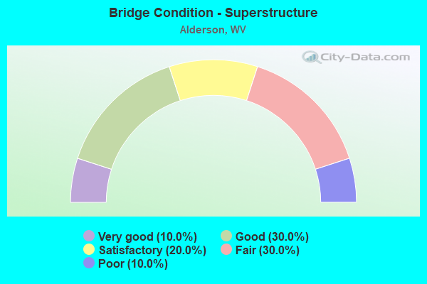
- Bridge Condition - Superstructure
- 10.0%Very good
- 30.0%Good
- 20.0%Satisfactory
- 30.0%Fair
- 10.0%Poor
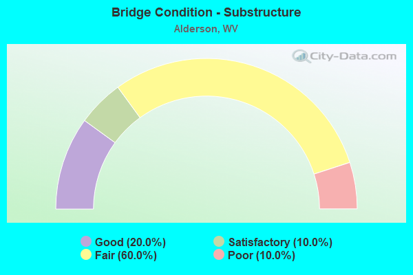
- Bridge Condition - Substructure
- 20.0%Good
- 10.0%Satisfactory
- 60.0%Fair
- 10.0%Poor
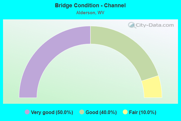
- Bridge Condition - Channel
- 50.0%Very good
- 40.0%Good
- 10.0%Fair
Find on map >> Show street view
Structure Number: 13A07, Location: 0.25 Miles North of WV 12 (Lat: 37.735069, Lng: -80.629069), Route carried "on" structure: County highway 2500, Year Built: 1923, Status: Posted for load, Structure Length: 3.30m (10.83ft), Average Daily Traffic: 450 (year 2019), Truck Traffic: 2%, Average Future Daily Traffic: 597 (year 2039), Design Load: H 10, Features Intersected: MUDDY CREEK, Facility Carried by Structure: COUNTY ROUTE 25
Minimum Vertical Clearance: 30+ m (98+ ft), Kilometerpoint: 0.402, Lanes on structure: 2, Owner: State Highway Agency, Approaching Roadway Width: 5.5m (18.0ft), Material/Design: Concrete continuous, Design/Construction: Arch - Deck, Number Of Spans In Main Unit: 1, Number Of Approach Spans: 2, Length of Maximum Span: 15.2m (49.9ft), Curb or Sidewalk Widths: Left: 0.1m (0.3ft), Right: 0.1m (0.3ft), Curb-To-Curb Width: 5.3m (17.4ft), Out-to-Out Width: 5.9m (19.4ft)
Condition: Deck: Fair, Superstructure: Fair, Substructure: Fair, Channel: Good, Operating Rating: 31.7 metric tons, Method Used To Determine Operating Rating: Field evaluation and documented engineering judgment, Inventory Rating: 14.5 metric tons, Method Used To Determine Inventory Rating: Field evaluation and documented engineering judgment, Structural Evaluation: Meets minimum limits, Deck Geometry: High priority of replacement, Waterway Adequacy: Equal to present minimum criteria, Approach Roadway Alignment: Equal to present minimum criteria, Length Of Structure Improvement: 4.21m (13.81ft), Designated Inspection Frequency: Every 24 months, Inspection Date: Febuary 2020, Bridge Improvement Cost: $510,000, Roadway Improvement Cost: $292,000, Total Project Cost: $802,000 ( Estimate for 2018), Deck Structure Type: Concrete Cast-file-Place, Wearing Surface/Protective System: Wearing Surface: Bituminous
Find on map >> Show street view
Structure Number: 13A071, Location: 0.23 Miles S. of CR 68 (Lat: 37.762481, Lng: -80.629700), Route carried "on" structure: County highway 2500, Year Built: 1978, Status: Open, Structure Length: 1.64m (5.38ft), Average Daily Traffic: 300 (year 2019), Truck Traffic: 2%, Average Future Daily Traffic: 398 (year 2039), Design Load: HS 20, Features Intersected: MUDDY CREEK, Facility Carried by Structure: COUNTY ROUTE 25
Minimum Vertical Clearance: 30+ m (98+ ft), Kilometerpoint: 3.862, Lanes on structure: 2, Owner: State Highway Agency, Approaching Roadway Width: 4.9m (16.1ft), Material/Design: Steel, Design/Construction: Stringer/Multi-beam, Number Of Spans In Main Unit: 1, Length of Maximum Span: 15.3m (50.2ft), Curb or Sidewalk Widths: Left: 0.2m (0.7ft), Right: 0.2m (0.7ft), Curb-To-Curb Width: 5.6m (18.4ft), Out-to-Out Width: 6.1m (20.0ft)
Condition: Deck: Satisfactory, Superstructure: Satisfactory, Substructure: Satisfactory, Channel: Good, Operating Rating: 58.0 metric tons, Method Used To Determine Operating Rating: Load Factor (LF), Inventory Rating: 35.4 metric tons, Method Used To Determine Inventory Rating: Load Factor (LF), Structural Evaluation: Equal to present minimum criteria, Deck Geometry: High priority of corrective action, Waterway Adequacy: Superior to present desirable criteria, Approach Roadway Alignment: Better than present minimum criteria, Length Of Structure Improvement: 1.52m (4.99ft), Designated Inspection Frequency: Every 24 months, Inspection Date: March 2020, Bridge Improvement Cost: $195,000, Roadway Improvement Cost: $80,000, Total Project Cost: $275,000 ( Estimate for 2020), Deck Structure Type: Closed Grating, Wearing Surface/Protective System: Wearing Surface: Bituminous
Find on map >> Show street view
Structure Number: 13A171, Location: 0.16 Miles W. of WV 12 (Lat: 37.761750, Lng: -80.610261), Route carried "on" structure: County highway 6600, Year Built: 1913, Status: Posted for load, Structure Length: 1.57m (5.15ft), Average Daily Traffic: 70 (year 2019), Truck Traffic: 10%, Average Future Daily Traffic: 90 (year 2039), Features Intersected: MILL CREEK, Facility Carried by Structure: COUNTY ROUTE 66
Minimum Vertical Clearance: 30+ m (98+ ft), Kilometerpoint: 2.398, Lanes on structure: 1, Owner: State Highway Agency, Approaching Roadway Width: 4.3m (14.1ft), Material/Design: Concrete, Design/Construction: Arch - Deck, Number Of Spans In Main Unit: 1, Length of Maximum Span: 15.1m (49.5ft), Curb-To-Curb Width: 4.3m (14.1ft), Out-to-Out Width: 4.8m (15.7ft)
Condition: Superstructure: Poor, Substructure: Poor, Channel: Very good, Operating Rating: 28.1 metric tons, Method Used To Determine Operating Rating: Field evaluation and documented engineering judgment, Inventory Rating: 11.8 metric tons, Method Used To Determine Inventory Rating: Field evaluation and documented engineering judgment, Structural Evaluation: Meets minimum limits, Deck Geometry: Equal to present minimum criteria, Waterway Adequacy: Superior to present desirable criteria, Approach Roadway Alignment: High priority of corrective action, Length Of Structure Improvement: 2.29m (7.51ft), Designated Inspection Frequency: Every 24 months, Other Special Inspection Frequency: Every 12 months, Inspection Date: May 2020, Other Special Inspection Date: May 2021, Bridge Improvement Cost: $222,000, Roadway Improvement Cost: $157,000, Total Project Cost: $379,000 ( Estimate for 2021), Wearing Surface/Protective System: Wearing Surface: Bituminous
Find on map >> Show street view
Structure Number: 13A172, Location: 0.83 Miles N. of CR 25 (Lat: 37.770289, Lng: -80.640250), Route carried "on" structure: County highway 6800, Year Built: 1955, Status: Open, Structure Length: 1.84m (6.04ft), Average Daily Traffic: 51 (year 2019), Truck Traffic: 10%, Average Future Daily Traffic: 65 (year 2039), Features Intersected: MUDDY CREEK, Facility Carried by Structure: COUNTY ROUTE 68
Minimum Vertical Clearance: 30+ m (98+ ft), Kilometerpoint: 1.336, Lanes on structure: 1, Owner: State Highway Agency, Approaching Roadway Width: 4.3m (14.1ft), Material/Design: Steel, Design/Construction: Girder and Floorbeam System, Number Of Spans In Main Unit: 1, Length of Maximum Span: 17.7m (58.1ft), Curb-To-Curb Width: 4.1m (13.5ft), Out-to-Out Width: 4.3m (14.1ft)
Condition: Deck: Fair, Superstructure: Fair, Substructure: Fair, Channel: Good, Operating Rating: 56.2 metric tons, Method Used To Determine Operating Rating: Load Factor (LF), Inventory Rating: 34.5 metric tons, Method Used To Determine Inventory Rating: Load Factor (LF), Structural Evaluation: Somewhat better than minimum adequacy, Deck Geometry: Somewhat better than minimum adequacy, Waterway Adequacy: Superior to present desirable criteria, Approach Roadway Alignment: Equal to present minimum criteria, Designated Inspection Frequency: Every 24 months, Critical Feature Inspection Frequency: Every 24 months, Inspection Date: April 2020, Critical Feature Inspection Date: April 2020, Deck Structure Type: Wood or Timber, Wearing Surface/Protective System: Deck Protection: Other
Find on map >> Show street view
Structure Number: 13A238, Location: 0.03 Miles E. of CR 3/1 (Lat: 37.730900, Lng: -80.656100), Route carried "on" structure: State highway 300, Year Built: 2000, Status: Open, Structure Length: 4.08m (13.39ft), Average Daily Traffic: 2,400 (year 2017), Truck Traffic: 5%, Average Future Daily Traffic: 3,184 (year 2037), Design Load: HL 93, Features Intersected: MUDDY CREEK, Facility Carried by Structure: WV 3
Minimum Vertical Clearance: 30+ m (98+ ft), Kilometerpoint: 0.660, Lanes on structure: 2, Base Highway Network: Yes, Owner: State Highway Agency, Approaching Roadway Width: 8.5m (27.9ft), Skew: 1 degrees, Material/Design: Concrete continuous, Design/Construction: Stringer/Multi-beam, Number Of Spans In Main Unit: 2, Length of Maximum Span: 20.1m (65.9ft), Curb-To-Curb Width: 10.4m (34.1ft), Out-to-Out Width: 11.5m (37.7ft)
Condition: Deck: Good, Superstructure: Good, Substructure: Good, Channel: Very good, Operating Rating: 59.9 metric tons, Method Used To Determine Operating Rating: Load and Resistance Factor (LRFR), Inventory Rating: 46.3 metric tons, Method Used To Determine Inventory Rating: Load and Resistance Factor (LRFR), Structural Evaluation: Better than present minimum criteria, Deck Geometry: Somewhat better than minimum adequacy, Waterway Adequacy: Superior to present desirable criteria, Approach Roadway Alignment: Equal to present desirable criteria, Designated Inspection Frequency: Every 48 months, Inspection Date: October 2019, Deck Structure Type: Concrete Cast-file-Place, Wearing Surface/Protective System: Wearing Surface: Monolithic Concrete, Deck Protection: Epoxy Coated Reinforcing
Find on map >> Show street view
Structure Number: 13A245, Location: 0.25 Miles N. of WV 12 (Lat: 37.748181, Lng: -80.617911), Route carried "on" structure: County highway 5404, Year Built: 2005, Status: Open, Structure Length: 1.48m (4.86ft), Average Daily Traffic: 21 (year 2020), Truck Traffic: 10%, Average Future Daily Traffic: 27 (year 2040), Design Load: HS 25 or greater, Features Intersected: MUDDY CREEK, Facility Carried by Structure: COUNTY ROUTE 54/4
Minimum Vertical Clearance: 30+ m (98+ ft), Kilometerpoint: 0.402, Lanes on structure: 1, Owner: State Highway Agency, Approaching Roadway Width: 3.0m (9.8ft), Material/Design: Steel, Design/Construction: Stringer/Multi-beam, Number Of Spans In Main Unit: 1, Length of Maximum Span: 14.0m (45.9ft), Curb-To-Curb Width: 4.2m (13.8ft), Out-to-Out Width: 4.3m (14.1ft)
Condition: Deck: Satisfactory, Superstructure: Satisfactory, Substructure: Fair, Channel: Very good, Operating Rating: 88.9 metric tons, Method Used To Determine Operating Rating: Load Factor (LF), Inventory Rating: 70.7 metric tons, Method Used To Determine Inventory Rating: Load Factor (LF), Structural Evaluation: Somewhat better than minimum adequacy, Deck Geometry: Somewhat better than minimum adequacy, Waterway Adequacy: Equal to present desirable criteria, Approach Roadway Alignment: Equal to present minimum criteria, Designated Inspection Frequency: Every 48 months, Inspection Date: October 2021, Deck Structure Type: Wood or Timber
Find on map >> Show street view
Structure Number: 32A001, Location: 0.01 Miles E. of WV 12 (Lat: 37.726331, Lng: -80.649750), Route carried "on" structure: State highway 300, Year Built: 1975, Status: Open, Structure Length: 26.65m (87.43ft), Average Daily Traffic: 700 (year 2019), Truck Traffic: 11%, Average Future Daily Traffic: 1,358 (year 2039), Design Load: HS 20, Features Intersected: GREENBRIER RIVER,CSX RR, Facility Carried by Structure: WV 3
Minimum Vertical Clearance: 30+ m (98+ ft), Kilometerpoint: 0.016, Lanes on structure: 2, Owner: State Highway Agency, Approaching Roadway Width: 7.9m (25.9ft), Material/Design: Steel continuous, Design/Construction: Stringer/Multi-beam, Number Of Spans In Main Unit: 4, Number Of Approach Spans: 3, Length of Maximum Span: 42.1m (138.1ft), Curb or Sidewalk Widths: Left: 1.5m (4.9ft), Right: 0.0m, Curb-To-Curb Width: 9.3m (30.5ft), Out-to-Out Width: 12.1m (39.7ft)
Condition: Deck: Satisfactory, Superstructure: Good, Substructure: Fair, Channel: Good, Operating Rating: 73.5 metric tons, Method Used To Determine Operating Rating: Load Factor (LF), Inventory Rating: 44.4 metric tons, Method Used To Determine Inventory Rating: Load Factor (LF), Structural Evaluation: Somewhat better than minimum adequacy, Deck Geometry: Equal to present minimum criteria, Underclear: Somewhat better than minimum adequacy, Waterway Adequacy: Equal to present desirable criteria, Approach Roadway Alignment: Meets minimum limits, Designated Inspection Frequency: Every 24 months, Underwater Inspection Frequency: Every 60 months, Inspection Date: April 2021, Underwater Inspection Date: August 2020, Deck Structure Type: Concrete Cast-file-Place, Wearing Surface/Protective System: Wearing Surface: Latex Concrete
Find on map >> Show street view
Structure Number: 32A094, Location: 0.46 Miles W. of WV 3 (Lat: 37.697131, Lng: -80.667650), Route carried "on" structure: County highway 302, Year Built: 2010, Status: Open, Structure Length: 1.28m (4.20ft), Average Daily Traffic: 50 (year 2019), Truck Traffic: 8%, Average Future Daily Traffic: 61 (year 2039), Features Intersected: WOLF CREEK, Facility Carried by Structure: COUNTY ROUTE 3/2
Minimum Vertical Clearance: 30+ m (98+ ft), Kilometerpoint: 0.740, Lanes on structure: 2, Owner: State Highway Agency, Approaching Roadway Width: 4.3m (14.1ft), Material/Design: Steel, Design/Construction: Stringer/Multi-beam, Number Of Spans In Main Unit: 1, Length of Maximum Span: 11.6m (38.1ft), Curb-To-Curb Width: 4.9m (16.1ft), Out-to-Out Width: 4.9m (16.1ft)
Condition: Deck: Very good, Superstructure: Very good, Substructure: Fair, Channel: Very good, Operating Rating: 49.0 metric tons, Method Used To Determine Operating Rating: Load and Resistance Factor (LRFR), Inventory Rating: 38.1 metric tons, Method Used To Determine Inventory Rating: Load and Resistance Factor (LRFR), Structural Evaluation: Somewhat better than minimum adequacy, Deck Geometry: High priority of corrective action, Waterway Adequacy: Equal to present minimum criteria, Approach Roadway Alignment: Meets minimum limits, Designated Inspection Frequency: Every 24 months, Inspection Date: August 2020, Deck Structure Type: Wood or Timber, Wearing Surface/Protective System: Deck Protection: Other
Find on map >> Show street view
Structure Number: 45A017, Location: 0.70 Miles W. of WV 3 (Lat: 37.726600, Lng: -80.687711), Route carried "on" structure: County highway 700, Year Built: 1984, Status: Open, Structure Length: 0.76m (2.49ft), Average Daily Traffic: 381 (year 2020), Truck Traffic: 5%, Average Future Daily Traffic: 480 (year 2040), Design Load: HS 20, Features Intersected: GRIFFITH CREEK, Facility Carried by Structure: COUNTY ROUTE 7
Minimum Vertical Clearance: 30+ m (98+ ft), Kilometerpoint: 1.127, Lanes on structure: 2, Owner: State Highway Agency, Approaching Roadway Width: 5.2m (17.1ft), Material/Design: Steel, Design/Construction: Stringer/Multi-beam, Number Of Spans In Main Unit: 1, Length of Maximum Span: 6.9m (22.6ft), Curb-To-Curb Width: 5.9m (19.4ft), Out-to-Out Width: 6.2m (20.3ft)
Condition: Deck: Good, Superstructure: Fair, Substructure: Fair, Channel: Fair, Operating Rating: 56.2 metric tons, Method Used To Determine Operating Rating: Load Factor (LF), Inventory Rating: 34.5 metric tons, Method Used To Determine Inventory Rating: Load Factor (LF), Structural Evaluation: Somewhat better than minimum adequacy, Deck Geometry: High priority of corrective action, Waterway Adequacy: Better than present minimum criteria, Approach Roadway Alignment: Equal to present minimum criteria, Length Of Structure Improvement: 1.52m (4.99ft), Designated Inspection Frequency: Every 24 months, Inspection Date: March 2021, Bridge Improvement Cost: $305,000, Roadway Improvement Cost: $181,000, Total Project Cost: $486,000 ( Estimate for 2021), Deck Structure Type: Wood or Timber, Wearing Surface/Protective System: Wearing Surface: Bituminous, Deck Protection: Other
Find on map >> Show street view
Structure Number: 45A091, Location: 0.30 Miles N. of CR 7 (Lat: 37.733539, Lng: -80.702431), Route carried "on" structure: County highway 714, Year Built: 2011, Status: Open, Structure Length: 1.50m (4.92ft), Average Daily Traffic: 44 (year 2019), Truck Traffic: 5%, Average Future Daily Traffic: 55 (year 2039), Features Intersected: GRIFFITH CREEK, Facility Carried by Structure: COUNTY ROUTE 7/14
Minimum Vertical Clearance: 30+ m (98+ ft), Kilometerpoint: 0.483, Lanes on structure: 2, Owner: State Highway Agency, Approaching Roadway Width: 3.7m (12.1ft), Skew: 3 degrees, Material/Design: Steel, Design/Construction: Stringer/Multi-beam, Number Of Spans In Main Unit: 1, Length of Maximum Span: 13.7m (44.9ft), Curb-To-Curb Width: 5.2m (17.1ft), Out-to-Out Width: 5.4m (17.7ft)
Condition: Deck: Satisfactory, Superstructure: Good, Substructure: Good, Channel: Very good, Operating Rating: 51.7 metric tons, Method Used To Determine Operating Rating: Load and Resistance Factor (LRFR), Inventory Rating: 39.9 metric tons, Method Used To Determine Inventory Rating: Load and Resistance Factor (LRFR), Structural Evaluation: Better than present minimum criteria, Deck Geometry: High priority of corrective action, Waterway Adequacy: Equal to present desirable criteria, Approach Roadway Alignment: Equal to present minimum criteria, Designated Inspection Frequency: Every 24 months, Inspection Date: January 2021, Deck Structure Type: Wood or Timber, Wearing Surface/Protective System: Deck Protection: Other