Bridge Statistics for Alloway, New Jersey (NJ)
Condition, Traffic, Stress, Structural Evaluation, Project Costs
- National Bridge Inventory (NBI) Statistics
- 16Number of bridges
- 62ft / 19.4mTotal length
- $1,207,000Total costs
- 26,450Total average daily traffic
- 896Total average daily truck traffic
- 31,900Total future (year 2040) average daily traffic
- National Bridge Inventory (NBI) Registered Bridges for Alloway
- No street view available for this location
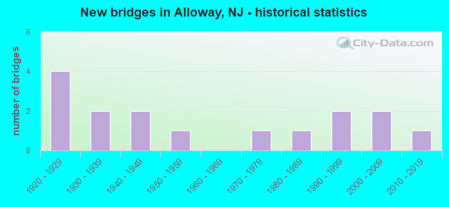
- New bridges - historical statistics
- 41920-1929
- 21930-1939
- 21940-1949
- 11950-1959
- 11970-1979
- 11980-1989
- 21990-1999
- 22000-2009
- 12010-2019
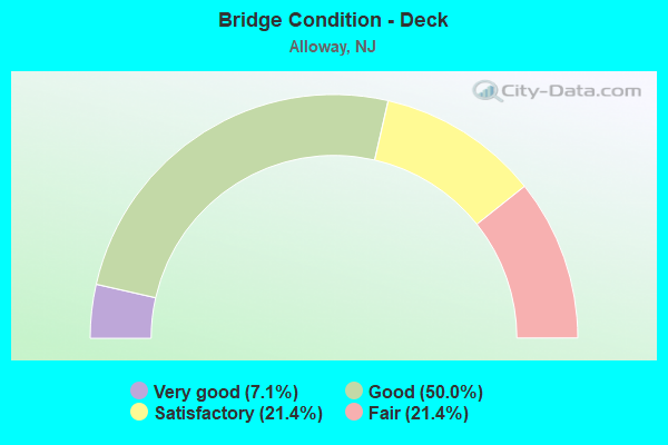
- Bridge Condition - Deck
- 7.1%Very good
- 50.0%Good
- 21.4%Satisfactory
- 21.4%Fair
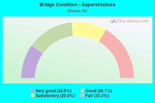
- Bridge Condition - Superstructure
- 20.0%Very good
- 26.7%Good
- 20.0%Satisfactory
- 33.3%Fair
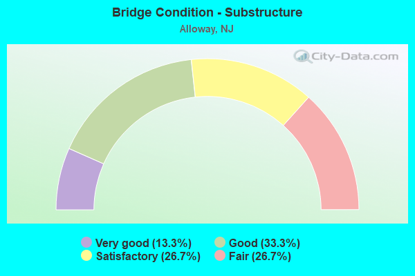
- Bridge Condition - Substructure
- 13.3%Very good
- 33.3%Good
- 26.7%Satisfactory
- 26.7%Fair
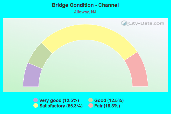
- Bridge Condition - Channel
- 12.5%Very good
- 12.5%Good
- 56.3%Satisfactory
- 18.8%Fair
Find on map >> Show street view
Structure Number: 1700527, Location: 3.1 MI E INT CR540 & NJ45 (Lat: 39.596281, Lng: -75.375900), Route carried "on" structure: Other road , Year Built: 1928, Status: Open, Structure Length: 0.73m (2.40ft), Average Daily Traffic: 550 (year 2021), Truck Traffic: 3%, Average Future Daily Traffic: 660 (year 2041), Features Intersected: SWEDES RUN, Facility Carried by Structure: SWEDES BRIDGE ROAD
Minimum Vertical Clearance: 30+ m (98+ ft), Kilometerpoint: 0.000, Lanes on structure: 2, Owner: County Highway Agency, Approaching Roadway Width: 9.1m (29.9ft), Material/Design: Concrete, Design/Construction: Tee Beam, Number Of Spans In Main Unit: 1, Length of Maximum Span: 6.4m (21.0ft), Curb-To-Curb Width: 9.1m (29.9ft), Out-to-Out Width: 9.8m (32.2ft)
Condition: Deck: Good, Superstructure: Satisfactory, Substructure: Fair, Channel: Fair, Operating Rating: 45.4 metric tons, Method Used To Determine Operating Rating: Load Factor (LF), Inventory Rating: 27.2 metric tons, Method Used To Determine Inventory Rating: Load Factor (LF), Structural Evaluation: Somewhat better than minimum adequacy, Deck Geometry: Equal to present minimum criteria, Waterway Adequacy: Better than present minimum criteria, Approach Roadway Alignment: Equal to present desirable criteria, Designated Inspection Frequency: Every 24 months, Underwater Inspection Frequency: Every 48 months, Inspection Date: August 2021, Underwater Inspection Date: December 2021, Deck Structure Type: Concrete Cast-file-Place, Wearing Surface/Protective System: Wearing Surface: Bituminous
Find on map >> Show street view
Structure Number: 1700973, Location: 2.2 MI. NE OF NJ 49 (Lat: 39.554139, Lng: -75.373900), Route carried "on" structure: Other road , Year Built: 1923, Status: Open, Structure Length: 0.88m (2.89ft), Average Daily Traffic: 416 (year 2021), Truck Traffic: 3%, Average Future Daily Traffic: 499 (year 2041), Features Intersected: MILL POND, Facility Carried by Structure: WATERWORKS ROAD
Minimum Vertical Clearance: 30+ m (98+ ft), Kilometerpoint: 0.000, Lanes on structure: 2, Owner: County Highway Agency, Approaching Roadway Width: 6.1m (20.0ft), Material/Design: Concrete, Design/Construction: Tee Beam, Number Of Spans In Main Unit: 1, Length of Maximum Span: 8.2m (26.9ft), Curb-To-Curb Width: 6.1m (20.0ft), Out-to-Out Width: 6.9m (22.6ft)
Condition: Deck: Fair, Superstructure: Satisfactory, Substructure: Fair, Channel: Fair, Operating Rating: 63.5 metric tons, Method Used To Determine Operating Rating: Load Factor (LF), Inventory Rating: 38.1 metric tons, Method Used To Determine Inventory Rating: Load Factor (LF), Structural Evaluation: Somewhat better than minimum adequacy, Deck Geometry: High priority of corrective action, Waterway Adequacy: Equal to present desirable criteria, Approach Roadway Alignment: Better than present minimum criteria, Length Of Structure Improvement: 0.88m (2.89ft), Designated Inspection Frequency: Every 24 months, Inspection Date: August 2021, Bridge Improvement Cost: $44,000, Roadway Improvement Cost: $10,000, Total Project Cost: $67,000 ( Estimate for 2021), Deck Structure Type: Concrete Cast-file-Place, Wearing Surface/Protective System: Wearing Surface: Bituminous
Find on map >> Show street view
Structure Number: 1701003, Location: 3.9 MI. NORTH OF NJ 49 (Lat: 39.542900, Lng: -75.354689), Route carried "on" structure: County highway 540, Year Built: 2013, Status: Open, Structure Length: 1.04m (3.41ft), Average Daily Traffic: 2,156 (year 2021), Truck Traffic: 3%, Average Future Daily Traffic: 2,587 (year 2041), Design Load: HL 93, Features Intersected: DEEP RUN
Minimum Vertical Clearance: 30+ m (98+ ft), Kilometerpoint: 23.319, Lanes on structure: 2, Owner: County Highway Agency, Approaching Roadway Width: 9.1m (29.9ft), Material/Design: Concrete, Design/Construction: Arch - Deck, Number Of Spans In Main Unit: 1, Length of Maximum Span: 9.8m (32.2ft), Curb-To-Curb Width: 9.1m (29.9ft), Out-to-Out Width: 10.2m (33.5ft)
Condition: Superstructure: Good, Substructure: Very good, Channel: Good, Operating Rating: 96.9 metric tons, Method Used To Determine Operating Rating: Load and Resistance Factor Rating (LRFR) rating reported by rating factor(RF) method using HL-93 loadings, Inventory Rating: 96.6 metric tons, Method Used To Determine Inventory Rating: Load and Resistance Factor Rating (LRFR) rating reported by rating factor(RF) method using HL-93 loadings, Structural Evaluation: Better than present minimum criteria, Deck Geometry: Meets minimum limits, Waterway Adequacy: Equal to present desirable criteria, Approach Roadway Alignment: Better than present minimum criteria, Designated Inspection Frequency: Every 24 months, Inspection Date: September 2021
Find on map >> Show street view
Structure Number: 1701028, Location: 0.75 MI N OF CR 581 (Lat: 39.565000, Lng: -75.365000), Route carried "on" structure: County highway 540, Year Built: 1930, Status: Open, Structure Length: 3.90m (12.80ft), Average Daily Traffic: 2,732 (year 2021), Truck Traffic: 3%, Average Future Daily Traffic: 3,278 (year 2041), Features Intersected: ALLOWAYS CREEK
Minimum Vertical Clearance: 30+ m (98+ ft), Kilometerpoint: 20.744, Lanes on structure: 2, Owner: County Highway Agency, Approaching Roadway Width: 7.0m (23.0ft), Material/Design: Steel, Design/Construction: Stringer/Multi-beam, Number Of Spans In Main Unit: 1, Number Of Approach Spans: 2, Length of Maximum Span: 16.5m (54.1ft), Curb or Sidewalk Widths: Left: 1.4m (4.6ft), Right: 1.4m (4.6ft), Curb-To-Curb Width: 9.3m (30.5ft), Out-to-Out Width: 13.2m (43.3ft)
Condition: Deck: Fair, Superstructure: Fair, Substructure: Fair, Channel: Fair, Operating Rating: 62.6 metric tons, Method Used To Determine Operating Rating: Load Factor (LF), Inventory Rating: 37.2 metric tons, Method Used To Determine Inventory Rating: Load Factor (LF), Structural Evaluation: Somewhat better than minimum adequacy, Deck Geometry: Meets minimum limits, Waterway Adequacy: Somewhat better than minimum adequacy, Approach Roadway Alignment: Equal to present desirable criteria, Length Of Structure Improvement: 3.90m (12.80ft), Designated Inspection Frequency: Every 24 months, Underwater Inspection Frequency: Every 24 months, Inspection Date: September 2021, Underwater Inspection Date: December 2021, Bridge Improvement Cost: $27,000, Roadway Improvement Cost: $4,000, Total Project Cost: $419,000 ( Estimate for 2021), Deck Structure Type: Concrete Cast-file-Place, Wearing Surface/Protective System: Wearing Surface: Bituminous
Find on map >> Show street view
Structure Number: 170103, Location: 2.3 MI EAST OF NJ 49 (Lat: 39.559150, Lng: -75.374219), Route carried "on" structure: County highway 581, Year Built: 1941, Status: Open, Structure Length: 0.88m (2.89ft), Average Daily Traffic: 2,381 (year 2021), Truck Traffic: 3%, Average Future Daily Traffic: 2,858 (year 2041), Design Load: H 15, Features Intersected: DEEP RUN
Minimum Vertical Clearance: 30+ m (98+ ft), Kilometerpoint: 3.685, Lanes on structure: 2, Owner: County Highway Agency, Approaching Roadway Width: 9.2m (30.2ft), Material/Design: Steel, Design/Construction: Stringer/Multi-beam, Number Of Spans In Main Unit: 1, Length of Maximum Span: 7.9m (25.9ft), Curb-To-Curb Width: 9.2m (30.2ft), Out-to-Out Width: 10.4m (34.1ft)
Condition: Deck: Good, Superstructure: Fair, Substructure: Satisfactory, Channel: Satisfactory, Operating Rating: 65.3 metric tons, Method Used To Determine Operating Rating: Load Factor (LF), Inventory Rating: 39.0 metric tons, Method Used To Determine Inventory Rating: Load Factor (LF), Structural Evaluation: Somewhat better than minimum adequacy, Deck Geometry: Meets minimum limits, Waterway Adequacy: Superior to present desirable criteria, Approach Roadway Alignment: Equal to present desirable criteria, Length Of Structure Improvement: 0.91m (2.99ft), Designated Inspection Frequency: Every 24 months, Inspection Date: August 2021, Bridge Improvement Cost: $264,000, Total Project Cost: $303,000 ( Estimate for 2021), Deck Structure Type: Concrete Cast-file-Place, Wearing Surface/Protective System: Wearing Surface: Bituminous
Find on map >> Show street view
Structure Number: 1701038, Location: 4.1 MI. EAST OF NJ 49 (Lat: 39.559900, Lng: -75.339769), Route carried "on" structure: County highway 611, Year Built: 1954, Status: Open, Structure Length: 0.88m (2.89ft), Average Daily Traffic: 1,468 (year 2021), Truck Traffic: 3%, Average Future Daily Traffic: 1,762 (year 2041), Design Load: HS 20, Features Intersected: BRANCH OF ALLOWAYS CREEK
Minimum Vertical Clearance: 30+ m (98+ ft), Kilometerpoint: 1.239, Lanes on structure: 2, Owner: County Highway Agency, Approaching Roadway Width: 9.2m (30.2ft), Material/Design: Steel, Design/Construction: Stringer/Multi-beam, Number Of Spans In Main Unit: 1, Length of Maximum Span: 7.9m (25.9ft), Curb or Sidewalk Widths: Left: 0.6m (2.0ft), Right: 0.6m (2.0ft), Curb-To-Curb Width: 9.2m (30.2ft), Out-to-Out Width: 11.3m (37.1ft)
Condition: Deck: Good, Superstructure: Satisfactory, Substructure: Satisfactory, Channel: Satisfactory, Inventory Rating: 59.0 metric tons, Method Used To Determine Inventory Rating: Load Factor (LF), Structural Evaluation: Equal to present minimum criteria, Deck Geometry: Somewhat better than minimum adequacy, Waterway Adequacy: Equal to present desirable criteria, Approach Roadway Alignment: Equal to present desirable criteria, Designated Inspection Frequency: Every 24 months, Inspection Date: August 2021, Deck Structure Type: Concrete Cast-file-Place, Wearing Surface/Protective System: Wearing Surface: Bituminous
Find on map >> Show street view
Structure Number: 170104, Location: 4.5 MILES EAST OF NJ 49 (Lat: 39.559169, Lng: -75.336669), Route carried "on" structure: Other road , Year Built: 1927, Status: Open, Structure Length: 0.98m (3.22ft), Average Daily Traffic: 170 (year 2021), Truck Traffic: 3%, Average Future Daily Traffic: 205 (year 2041), Features Intersected: CARLISLE RUN, Facility Carried by Structure: CAMP EDGE ROAD
Minimum Vertical Clearance: 30+ m (98+ ft), Kilometerpoint: 0.000, Lanes on structure: 2, Owner: County Highway Agency, Approaching Roadway Width: 6.1m (20.0ft), Material/Design: Concrete, Design/Construction: Tee Beam, Number Of Spans In Main Unit: 1, Length of Maximum Span: 9.1m (29.9ft), Curb-To-Curb Width: 6.1m (20.0ft), Out-to-Out Width: 6.9m (22.6ft)
Condition: Deck: Satisfactory, Superstructure: Good, Substructure: Satisfactory, Channel: Satisfactory, Operating Rating: 46.3 metric tons, Method Used To Determine Operating Rating: Load Factor (LF), Inventory Rating: 28.1 metric tons, Method Used To Determine Inventory Rating: Load Factor (LF), Structural Evaluation: Equal to present minimum criteria, Deck Geometry: Meets minimum limits, Waterway Adequacy: Equal to present minimum criteria, Approach Roadway Alignment: Equal to present desirable criteria, Designated Inspection Frequency: Every 24 months, Inspection Date: September 2021, Deck Structure Type: Concrete Cast-file-Place, Wearing Surface/Protective System: Wearing Surface: Bituminous
Find on map >> Show street view
Structure Number: 1701073, Location: 2 Mi. North of CR 581 (Lat: 39.583439, Lng: -75.335981), Route carried "on" structure: Other road , Year Built: 2001, Status: Open, Structure Length: 1.28m (4.20ft), Average Daily Traffic: 275 (year 2021), Truck Traffic: 3%, Average Future Daily Traffic: 335 (year 2041), Design Load: HS 20+Mod, Features Intersected: ALLOWAYS CREEK, Facility Carried by Structure: WITT ROAD
Minimum Vertical Clearance: 30+ m (98+ ft), Kilometerpoint: 0.000, Lanes on structure: 2, Owner: County Highway Agency, Approaching Roadway Width: 9.1m (29.9ft), Material/Design: Prestressed concrete, Design/Construction: Slab, Number Of Spans In Main Unit: 1, Length of Maximum Span: 12.2m (40.0ft), Curb-To-Curb Width: 9.1m (29.9ft), Out-to-Out Width: 10.2m (33.5ft)
Condition: Deck: Good, Superstructure: Very good, Substructure: Very good, Channel: Very good, Operating Rating: 76.2 metric tons, Method Used To Determine Operating Rating: Load Factor (LF), Inventory Rating: 45.4 metric tons, Method Used To Determine Inventory Rating: Load Factor (LF), Structural Evaluation: Equal to present desirable criteria, Deck Geometry: Equal to present minimum criteria, Waterway Adequacy: Equal to present desirable criteria, Approach Roadway Alignment: Equal to present desirable criteria, Designated Inspection Frequency: Every 24 months, Inspection Date: September 2021, Deck Structure Type: Concrete Cast-file-Place, Wearing Surface/Protective System: Wearing Surface: Monolithic Concrete, Deck Protection: Epoxy Coated Reinforcing
Find on map >> Show street view
Structure Number: 1701074, Location: 5.3 MI. S. OF US 40 (Lat: 39.576669, Lng: -75.330000), Route carried "on" structure: County highway 581, Year Built: 2004, Status: Open, Structure Length: 1.98m (6.50ft), Average Daily Traffic: 1,390 (year 2021), Truck Traffic: 3%, Average Future Daily Traffic: 1,668 (year 2041), Design Load: HL 93, Features Intersected: ALLOWAYS CREEK
Minimum Vertical Clearance: 30+ m (98+ ft), Kilometerpoint: 8.127, Lanes on structure: 2, Owner: County Highway Agency, Approaching Roadway Width: 9.1m (29.9ft), Material/Design: Prestressed concrete, Design/Construction: Box Beam or Girders - Multiple, Number Of Spans In Main Unit: 1, Length of Maximum Span: 18.3m (60.0ft), Curb-To-Curb Width: 9.1m (29.9ft), Out-to-Out Width: 10.2m (33.5ft)
Condition: Deck: Very good, Superstructure: Very good, Substructure: Good, Channel: Satisfactory, Operating Rating: 76.8 metric tons, Method Used To Determine Operating Rating: Load and Resistance Factor Rating (LRFR) rating reported by rating factor(RF) method using HL-93 loadings, Inventory Rating: 59.3 metric tons, Method Used To Determine Inventory Rating: Load and Resistance Factor Rating (LRFR) rating reported by rating factor(RF) method using HL-93 loadings, Structural Evaluation: Better than present minimum criteria, Deck Geometry: Somewhat better than minimum adequacy, Waterway Adequacy: Somewhat better than minimum adequacy, Approach Roadway Alignment: Equal to present minimum criteria, Designated Inspection Frequency: Every 24 months, Inspection Date: September 2021, Deck Structure Type: Concrete Cast-file-Place, Wearing Surface/Protective System: Deck Protection: Epoxy Coated Reinforcing
Find on map >> Show street view
Structure Number: 1701088, Location: 4.1 MILES SW OF US 40 (Lat: 39.586389, Lng: -75.306669), Route carried "on" structure: Other road , Year Built: 1932, Status: Posted for load, Structure Length: 1.37m (4.49ft), Average Daily Traffic: 180 (year 2021), Truck Traffic: 3%, Average Future Daily Traffic: 220 (year 2041), Features Intersected: ALLOWAY CREEK, Facility Carried by Structure: PLEASANT HILL BRDG
Minimum Vertical Clearance: 30+ m (98+ ft), Kilometerpoint: 0.000, Lanes on structure: 2, Owner: County Highway Agency, Approaching Roadway Width: 6.2m (20.3ft), Skew: 3 degrees, Material/Design: Steel, Design/Construction: Stringer/Multi-beam, Number Of Spans In Main Unit: 1, Length of Maximum Span: 12.2m (40.0ft), Curb-To-Curb Width: 6.2m (20.3ft), Out-to-Out Width: 7.3m (24.0ft)
Condition: Deck: Fair, Superstructure: Fair, Substructure: Good, Channel: Satisfactory, Operating Rating: 51.7 metric tons, Method Used To Determine Operating Rating: Load Factor (LF), Inventory Rating: 30.8 metric tons, Method Used To Determine Inventory Rating: Load Factor (LF), Structural Evaluation: Somewhat better than minimum adequacy, Deck Geometry: Meets minimum limits, Waterway Adequacy: Equal to present minimum criteria, Approach Roadway Alignment: Equal to present desirable criteria, Length Of Structure Improvement: 1.37m (4.49ft), Designated Inspection Frequency: Every 24 months, Inspection Date: September 2021, Bridge Improvement Cost: $162,000, Roadway Improvement Cost: $1,000, Total Project Cost: $186,000 ( Estimate for 2021), Deck Structure Type: Concrete Cast-file-Place, Wearing Surface/Protective System: Wearing Surface: Bituminous
Find on map >> Show street view
Structure Number: 1701089, Location: 4.7 MI. SW OF US 40 (Lat: 39.578739, Lng: -75.309461), Route carried "on" structure: Other road , Year Built: 1980, Status: Open, Structure Length: 1.16m (3.81ft), Average Daily Traffic: 205 (year 2021), Truck Traffic: 3%, Average Future Daily Traffic: 250 (year 2041), Design Load: HS 20+Mod, Features Intersected: COOL RUN, Facility Carried by Structure: STOCKINGTOWN RD
Minimum Vertical Clearance: 30+ m (98+ ft), Kilometerpoint: 0.000, Lanes on structure: 2, Owner: County Highway Agency, Approaching Roadway Width: 11.8m (38.7ft), Skew: 1 degrees, Material/Design: Prestressed concrete, Design/Construction: Slab, Number Of Spans In Main Unit: 1, Length of Maximum Span: 10.4m (34.1ft), Curb-To-Curb Width: 11.8m (38.7ft), Out-to-Out Width: 12.9m (42.3ft)
Condition: Deck: Satisfactory, Superstructure: Good, Substructure: Good, Channel: Satisfactory, Inventory Rating: 66.2 metric tons, Method Used To Determine Inventory Rating: Load Factor (LF), Structural Evaluation: Better than present minimum criteria, Deck Geometry: Superior to present desirable criteria, Waterway Adequacy: Superior to present desirable criteria, Approach Roadway Alignment: Equal to present desirable criteria, Designated Inspection Frequency: Every 24 months, Inspection Date: September 2021, Deck Structure Type: Concrete Cast-file-Place, Wearing Surface/Protective System: Wearing Surface: Monolithic Concrete
Find on map >> Show street view
Structure Number: 1701097, Location: 5.0 MI. SOUTH OF NJ 45 (Lat: 39.578331, Lng: -75.346669), Route carried "on" structure: County highway 603, Year Built: 1941, Status: Open, Structure Length: 0.88m (2.89ft), Average Daily Traffic: 2,063 (year 2021), Truck Traffic: 3%, Average Future Daily Traffic: 2,476 (year 2041), Design Load: HS 20+Mod, Features Intersected: ALLOWAYS CREEK
Minimum Vertical Clearance: 30+ m (98+ ft), Kilometerpoint: 1.609, Lanes on structure: 2, Owner: County Highway Agency, Approaching Roadway Width: 9.4m (30.8ft), Material/Design: Steel, Design/Construction: Stringer/Multi-beam, Number Of Spans In Main Unit: 1, Length of Maximum Span: 7.9m (25.9ft), Curb-To-Curb Width: 9.4m (30.8ft), Out-to-Out Width: 10.4m (34.1ft)
Condition: Deck: Good, Superstructure: Fair, Substructure: Fair, Channel: Satisfactory, Operating Rating: 63.5 metric tons, Method Used To Determine Operating Rating: Load Factor (LF), Inventory Rating: 38.1 metric tons, Method Used To Determine Inventory Rating: Load Factor (LF), Structural Evaluation: Somewhat better than minimum adequacy, Deck Geometry: Meets minimum limits, Waterway Adequacy: Superior to present desirable criteria, Approach Roadway Alignment: Equal to present desirable criteria, Length Of Structure Improvement: 0.88m (2.89ft), Designated Inspection Frequency: Every 24 months, Underwater Inspection Frequency: Every 24 months, Inspection Date: August 2021, Underwater Inspection Date: November 2021, Bridge Improvement Cost: $203,000, Roadway Improvement Cost: $29,000, Total Project Cost: $232,000 ( Estimate for 2021), Deck Structure Type: Concrete Cast-file-Place, Wearing Surface/Protective System: Wearing Surface: Bituminous
Find on map >> Show street view
Structure Number: 1704151, Location: 0.15 MI N.OF JCT CR653 (Lat: 39.605661, Lng: -75.408250), Route carried "on" structure: State highway 45, Year Built: 1996, Status: Open, Structure Length: 1.25m (4.10ft), Average Daily Traffic: 5,192 (year 2021), Truck Traffic: 4%, Average Future Daily Traffic: 6,230 (year 2041), Design Load: HS 20+Mod, Features Intersected: MANNINGTON CREEK
Minimum Vertical Clearance: 30+ m (98+ ft), Kilometerpoint: 6.614, Lanes on structure: 2, Base Highway Network: Yes, Owner: State Highway Agency, Approaching Roadway Width: 13.4m (44.0ft), Material/Design: Prestressed concrete, Design/Construction: Slab, Number Of Spans In Main Unit: 1, Length of Maximum Span: 11.0m (36.1ft), Curb-To-Curb Width: 13.4m (44.0ft), Out-to-Out Width: 14.5m (47.6ft)
Condition: Deck: Good, Superstructure: Very good, Substructure: Good, Channel: Good, Inventory Rating: 46.3 metric tons, Method Used To Determine Inventory Rating: Load Factor (LF), Structural Evaluation: Better than present minimum criteria, Deck Geometry: Equal to present minimum criteria, Waterway Adequacy: Equal to present desirable criteria, Approach Roadway Alignment: Equal to present desirable criteria, Designated Inspection Frequency: Every 24 months, Underwater Inspection Frequency: Every 48 months, Inspection Date: May 2021, Underwater Inspection Date: May 2019, Deck Structure Type: Concrete Cast-file-Place, Wearing Surface/Protective System: Wearing Surface: Monolithic Concrete, Deck Protection: Epoxy Coated Reinforcing
Find on map >> Show street view
Structure Number: 1704152, Location: 1.47 Mile South of CR 669 (Lat: 39.615250, Lng: -75.391769), Route carried "on" structure: State highway 45, Year Built: 1994, Status: Open, Structure Length: 0.76m (2.49ft), Average Daily Traffic: 5,812 (year 2020), Truck Traffic: 4%, Average Future Daily Traffic: 7,092 (year 2040), Design Load: HS 25 or greater, Features Intersected: CULLIERS RUN
Minimum Vertical Clearance: 30+ m (98+ ft), Kilometerpoint: 8.433, Lanes on structure: 2, Base Highway Network: Yes, Owner: State Highway Agency, Approaching Roadway Width: 13.7m (44.9ft), Material/Design: Prestressed concrete, Design/Construction: Slab, Number Of Spans In Main Unit: 1, Length of Maximum Span: 6.7m (22.0ft), Curb-To-Curb Width: 13.7m (44.9ft), Out-to-Out Width: 14.8m (48.6ft)
Condition: Deck: Good, Superstructure: Good, Substructure: Good, Channel: Very good, Inventory Rating: 83.5 metric tons, Method Used To Determine Inventory Rating: Load Factor (LF), Structural Evaluation: Better than present minimum criteria, Deck Geometry: Superior to present desirable criteria, Waterway Adequacy: Equal to present desirable criteria, Approach Roadway Alignment: Equal to present desirable criteria, Designated Inspection Frequency: Every 24 months, Inspection Date: October 2020, Deck Structure Type: Concrete Cast-file-Place, Wearing Surface/Protective System: Wearing Surface: Monolithic Concrete, Deck Protection: Epoxy Coated Reinforcing
Find on map >> Show street view
Structure Number: 1710104, Location: 4 MILES SW OF US 40 (Lat: 39.586961, Lng: -75.305519), Route carried "on" structure: Other road , Year Built: 1976, Status: Open, Structure Length: 0.64m (2.10ft), Average Daily Traffic: 210 (year 2021), Truck Traffic: 3%, Average Future Daily Traffic: 255 (year 2041), Design Load: HS 20, Features Intersected: ALLOWAYS CREEK, Facility Carried by Structure: STOCKINGTOWN ROAD
Minimum Vertical Clearance: 30+ m (98+ ft), Kilometerpoint: 0.000, Lanes on structure: 2, Owner: County Highway Agency, Approaching Roadway Width: 11.5m (37.7ft), Skew: 3 degrees, Material/Design: Concrete, Design/Construction: Culvert, Number Of Spans In Main Unit: 1, Length of Maximum Span: 6.4m (21.0ft), Curb-To-Curb Width: 11.5m (37.7ft), Out-to-Out Width: 14.9m (48.9ft)
Condition: Channel: Satisfactory, Culverts: Good, Inventory Rating: 62.6 metric tons, Method Used To Determine Inventory Rating: Load Factor (LF), Structural Evaluation: Better than present minimum criteria, Deck Geometry: Superior to present desirable criteria, Waterway Adequacy: Equal to present desirable criteria, Approach Roadway Alignment: Equal to present desirable criteria, Designated Inspection Frequency: Every 24 months, Inspection Date: September 2021
Find on map >> Show street view
Structure Number: 1710109, Location: 3.1 MILES WEST OF NJ 77 (Lat: 39.575969, Lng: -75.290031), Route carried "on" structure: County highway 672, Year Built: 1929, Status: Posted for load, Structure Length: 0.79m (2.59ft), Average Daily Traffic: 1,250 (year 2021), Truck Traffic: 3%, Average Future Daily Traffic: 1,525 (year 2041), Features Intersected: COOL RUN
Minimum Vertical Clearance: 30+ m (98+ ft), Kilometerpoint: 3.428, Lanes on structure: 2, Owner: County Highway Agency, Approaching Roadway Width: 8.2m (26.9ft), Material/Design: Concrete, Design/Construction: Tee Beam, Number Of Spans In Main Unit: 1, Length of Maximum Span: 7.0m (23.0ft), Curb-To-Curb Width: 8.8m (28.9ft), Out-to-Out Width: 10.1m (33.1ft)
Condition: Deck: Satisfactory, Superstructure: Fair, Substructure: Satisfactory, Channel: Satisfactory, Operating Rating: 49.9 metric tons, Method Used To Determine Operating Rating: Load Factor (LF), Inventory Rating: 29.9 metric tons, Method Used To Determine Inventory Rating: Load Factor (LF), Structural Evaluation: Somewhat better than minimum adequacy, Deck Geometry: Somewhat better than minimum adequacy, Waterway Adequacy: Equal to present desirable criteria, Approach Roadway Alignment: Better than present minimum criteria, Designated Inspection Frequency: Every 24 months, Inspection Date: September 2021, Deck Structure Type: Concrete Cast-file-Place, Wearing Surface/Protective System: Wearing Surface: Bituminous