Bridge Statistics for Alton, Illinois (IL)
Condition, Traffic, Stress, Structural Evaluation, Project Costs
- National Bridge Inventory (NBI) Statistics
- 45Number of bridges
- 971ft / 296mTotal length
- $298,121,000Total costs
- 392,100Total average daily traffic
- 27,139Total average daily truck traffic
- National Bridge Inventory (NBI) Registered Bridges for Alton
- No street view available for this location
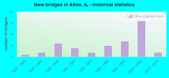
- New bridges - historical statistics
- 11930-1939
- 21940-1949
- 61950-1959
- 41960-1969
- 21970-1979
- 51980-1989
- 71990-1999
- 162000-2009
- 22010-2019
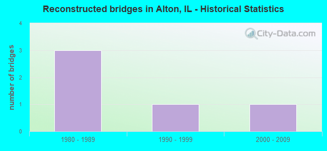
- Reconstructed bridges - Historical Statistics
- 31980-1989
- 11990-1999
- 12000-2009
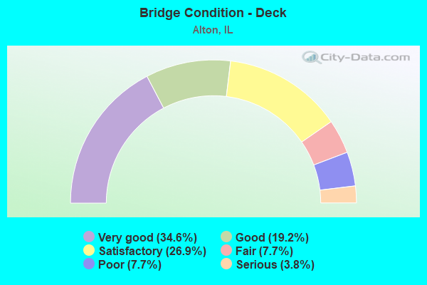
- Bridge Condition - Deck
- 34.6%Very good
- 19.2%Good
- 26.9%Satisfactory
- 7.7%Fair
- 7.7%Poor
- 3.8%Serious
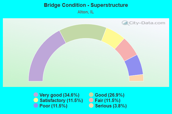
- Bridge Condition - Superstructure
- 34.6%Very good
- 26.9%Good
- 11.5%Satisfactory
- 11.5%Fair
- 11.5%Poor
- 3.8%Serious
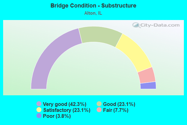
- Bridge Condition - Substructure
- 42.3%Very good
- 23.1%Good
- 23.1%Satisfactory
- 7.7%Fair
- 3.8%Poor
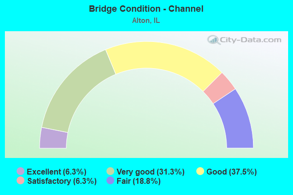
- Bridge Condition - Channel
- 6.3%Excellent
- 31.3%Very good
- 37.5%Good
- 6.3%Satisfactory
- 18.8%Fair
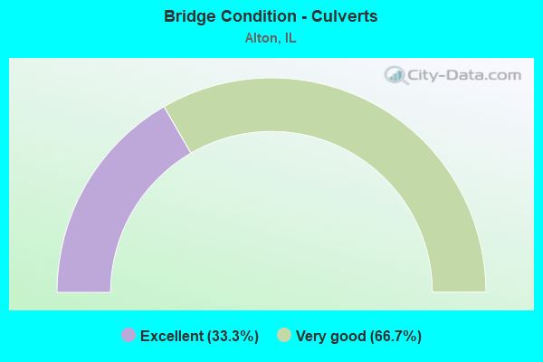
- Bridge Condition - Culverts
- 33.3%Excellent
- 66.7%Very good
Find on map >> Show street view
Structure Number: 600091, Location: 0.3mi E of IL 3 (Lat: 38.906506, Lng: -90.125053), Route carried "on" structure: State highway 111, Year Built: 1954, Year Reconstructed: 2002, Status: Open, Structure Length: 5.25m (17.22ft), Average Daily Traffic: 16,500 (year 2021), Truck Traffic: 7%, Average Future Daily Traffic: 23,320 (year 2032), Design Load: HS 20, Features Intersected: W Fork of Wood River, Facility Carried by Structure: IL 140
Minimum Vertical Clearance: 30+ m (98+ ft), Kilometerpoint: 42.260, Lanes on structure: 6, Base Highway Network: Yes, Owner: State Highway Agency, Approaching Roadway Width: 28.9m (94.8ft), Skew: 31 degrees, Material/Design: Prestressed concrete, Design/Construction: Stringer/Multi-beam, Number Of Spans In Main Unit: 3, Length of Maximum Span: 20.3m (66.6ft), Curb-To-Curb Width: 28.9m (94.8ft), Out-to-Out Width: 34.2m (112.2ft)
Condition: Deck: Satisfactory, Superstructure: Good, Substructure: Good, Channel: Good, Operating Rating: 57.3 metric tons, Method Used To Determine Operating Rating: Load Factor (LF) rating reported by rating factor (RF) method using MS18 loading, Inventory Rating: 34.3 metric tons, Method Used To Determine Inventory Rating: Load Factor (LF) rating reported by rating factor (RF) method using MS18 loading, Structural Evaluation: Better than present minimum criteria, Deck Geometry: Superior to present desirable criteria, Waterway Adequacy: Equal to present desirable criteria, Approach Roadway Alignment: Equal to present desirable criteria, Length Of Structure Improvement: 5.24m (17.19ft), Designated Inspection Frequency: Every 48 months, Other Special Inspection Frequency: Every 24 months, Inspection Date: Febuary 2021, Other Special Inspection Date: July 2021, Bridge Improvement Cost: $289,734,000, Roadway Improvement Cost: $66,000,000, Total Project Cost: $296,334,000, Deck Structure Type: Concrete Cast-file-Place, Wearing Surface/Protective System: Deck Protection: Epoxy Coated Reinforcing
Find on map >> Show street view
Structure Number: 60012, Location: 1 M N JCT 140 & 111 (Lat: 38.911703, Lng: -90.136894), Route carried "on" structure: State highway 3, Year Built: 1958, Status: Open, Structure Length: 11.37m (37.30ft), Average Daily Traffic: 16,800 (year 2021), Truck Traffic: 4%, Average Future Daily Traffic: 22,684 (year 2032), Design Load: HS 20, Features Intersected: ROGERS AV & BLOOMER
Minimum Vertical Clearance: 30+ m (98+ ft), Kilometerpoint: 271.940, Lanes on structure: 4, Lanes under structure: 2, Base Highway Network: Yes, Owner: State Highway Agency, Approaching Roadway Width: 14.6m (47.9ft), Skew: 34 degrees, Material/Design: Steel continuous, Design/Construction: Stringer/Multi-beam, Number Of Spans In Main Unit: 4, Length of Maximum Span: 31.4m (103.0ft), Curb-To-Curb Width: 18.4m (60.4ft), Out-to-Out Width: 19.4m (63.6ft)
Condition: Deck: Poor, Superstructure: Satisfactory, Substructure: Good, Operating Rating: 58.0 metric tons, Method Used To Determine Operating Rating: Load Factor (LF) rating reported by rating factor (RF) method using MS18 loading, Inventory Rating: 34.7 metric tons, Method Used To Determine Inventory Rating: Load Factor (LF) rating reported by rating factor (RF) method using MS18 loading, Structural Evaluation: Equal to present minimum criteria, Deck Geometry: Somewhat better than minimum adequacy, Underclear: Superior to present desirable criteria, Approach Roadway Alignment: Equal to present desirable criteria, Designated Inspection Frequency: Every 24 months, Inspection Date: April 2021, Deck Structure Type: Concrete Cast-file-Place, Wearing Surface/Protective System: Wearing Surface: Low Slump Concrete
Find on map >> Show street view
Structure Number: 600199, Location: 0.1mi E of IL 3 (Lat: 38.905719, Lng: -90.127039), Route carried "on" structure: State highway 111, Year Built: 1975, Status: Open, Structure Length: 5.75m (18.86ft), Average Daily Traffic: 16,500 (year 2021), Truck Traffic: 7%, Average Future Daily Traffic: 23,320 (year 2032), Design Load: HS 20, Features Intersected: Abandon quarry spur
Minimum Vertical Clearance: 30+ m (98+ ft), Kilometerpoint: 42.453, Lanes on structure: 6, Base Highway Network: Yes, Owner: State Highway Agency, Approaching Roadway Width: 23.0m (75.5ft), Skew: 32 degrees, Material/Design: Steel continuous, Design/Construction: Stringer/Multi-beam, Number Of Spans In Main Unit: 3, Length of Maximum Span: 21.9m (71.9ft), Curb-To-Curb Width: 23.0m (75.5ft), Out-to-Out Width: 32.6m (107.0ft)
Condition: Deck: Satisfactory, Superstructure: Fair, Substructure: Satisfactory, Operating Rating: 61.6 metric tons, Method Used To Determine Operating Rating: Load Factor (LF) rating reported by rating factor (RF) method using MS18 loading, Inventory Rating: 36.9 metric tons, Method Used To Determine Inventory Rating: Load Factor (LF) rating reported by rating factor (RF) method using MS18 loading, Structural Evaluation: Somewhat better than minimum adequacy, Deck Geometry: Meets minimum limits, Underclear: Equal to present desirable criteria, Approach Roadway Alignment: Equal to present desirable criteria, Designated Inspection Frequency: Every 24 months, Inspection Date: Febuary 2021, Deck Structure Type: Concrete Cast-file-Place, Wearing Surface/Protective System: Wearing Surface: Bituminous, Membrane: Built-up
Find on map >> Show street view
Structure Number: 600213, Location: .4MI W FOSTERBERG RD (Lat: 38.904828, Lng: -90.129731), Route carried "on" structure: State highway 3, Year Built: 1985, Status: Open, Structure Length: 7.07m (23.20ft), Average Daily Traffic: 13,000 (year 2021), Truck Traffic: 7%, Average Future Daily Traffic: 18,020 (year 2032), Design Load: HS 20, Features Intersected: ILL 140
Minimum Vertical Clearance: 4.72m (15.49ft), Kilometerpoint: 270.926, Lanes on structure: 4, Lanes under structure: 6, Base Highway Network: Yes, Owner: State Highway Agency, Approaching Roadway Width: 26.2m (86.0ft), Skew: 30 degrees, Material/Design: Steel continuous, Design/Construction: Stringer/Multi-beam, Number Of Spans In Main Unit: 2, Length of Maximum Span: 30.9m (101.4ft), Curb-To-Curb Width: 26.2m (86.0ft), Out-to-Out Width: 27.2m (89.2ft)
Condition: Deck: Good, Superstructure: Satisfactory, Substructure: Satisfactory, Operating Rating: 58.6 metric tons, Method Used To Determine Operating Rating: Load Factor (LF) rating reported by rating factor (RF) method using MS18 loading, Inventory Rating: 35.0 metric tons, Method Used To Determine Inventory Rating: Load Factor (LF) rating reported by rating factor (RF) method using MS18 loading, Structural Evaluation: Equal to present minimum criteria, Deck Geometry: Superior to present desirable criteria, Underclear: Equal to present minimum criteria, Approach Roadway Alignment: Equal to present desirable criteria, Designated Inspection Frequency: Every 24 months, Inspection Date: September 2021, Deck Structure Type: Concrete Cast-file-Place, Wearing Surface/Protective System: Deck Protection: Epoxy Coated Reinforcing
Find on map >> Show street view
Structure Number: 600254, Location: 1.42MI S. BELTLINE (Lat: 38.901139, Lng: -90.182900), Route carried "on" structure: US 67, Year Built: 1990, Status: Open, Structure Length: 4.25m (13.94ft), Average Daily Traffic: 10,400 (year 2021), Truck Traffic: 6%, Average Future Daily Traffic: 14,098 (year 2032), Design Load: HS 20, Features Intersected: ALBY ST
Minimum Vertical Clearance: 30+ m (98+ ft), Kilometerpoint: 3.878, Lanes on structure: 2, Lanes under structure: 2, Base Highway Network: Yes, Owner: State Highway Agency, Approaching Roadway Width: 13.4m (44.0ft), Skew: 2 degrees, Material/Design: Prestressed concrete, Design/Construction: Stringer/Multi-beam, Number Of Spans In Main Unit: 3, Length of Maximum Span: 17.1m (56.1ft), Curb-To-Curb Width: 13.4m (44.0ft), Out-to-Out Width: 14.4m (47.2ft)
Condition: Deck: Good, Superstructure: Good, Substructure: Very good, Operating Rating: 77.1 metric tons, Method Used To Determine Operating Rating: Load Factor (LF) rating reported by rating factor (RF) method using MS18 loading, Inventory Rating: 46.0 metric tons, Method Used To Determine Inventory Rating: Load Factor (LF) rating reported by rating factor (RF) method using MS18 loading, Structural Evaluation: Better than present minimum criteria, Deck Geometry: Equal to present minimum criteria, Underclear: Meets minimum limits, Approach Roadway Alignment: Equal to present desirable criteria, Designated Inspection Frequency: Every 48 months, Inspection Date: March 2021, Deck Structure Type: Concrete Cast-file-Place, Wearing Surface/Protective System: Deck Protection: Epoxy Coated Reinforcing
Find on map >> Show street view
Structure Number: 600255, Location: ALTON RIVERFRONT (Lat: 38.887842, Lng: -90.172542), Route carried "on" structure: US 67, Year Built: 1994, Status: Open, Structure Length: 140.82m (462.01ft), Average Daily Traffic: 23,800 (year 2021), Truck Traffic: 3%, Average Future Daily Traffic: 29,468 (year 2032), Design Load: HS 20+Mod, Features Intersected: MISSISSIPPI RIVER
Minimum Vertical Clearance: 30+ m (98+ ft), Kilometerpoint: 1.159, Lanes on structure: 4, Lanes under structure: 2, Base Highway Network: Yes, Owner: State Highway Agency, Approaching Roadway Width: 24.6m (80.7ft), Skew: 30 degrees, Navigation Control: Yes ( Vertical Clearance: 19.5m (64.0ft), Horizontal Clearance: 204.2m (669.9ft)), Material/Design: Steel continuous, Design/Construction: Stayed Girder, Number Of Spans In Main Unit: 3, Number Of Approach Spans: 19, Length of Maximum Span: 230.4m (755.9ft), Curb-To-Curb Width: 24.6m (80.7ft), Out-to-Out Width: 26.3m (86.3ft)
Condition: Deck: Satisfactory, Superstructure: Good, Substructure: Fair, Channel: Very good, Operating Rating: 59.0 metric tons, Method Used To Determine Operating Rating: Load Factor (LF) rating reported by rating factor (RF) method using MS18 loading, Inventory Rating: 35.3 metric tons, Method Used To Determine Inventory Rating: Load Factor (LF) rating reported by rating factor (RF) method using MS18 loading, Structural Evaluation: Somewhat better than minimum adequacy, Deck Geometry: Superior to present desirable criteria, Underclear: Superior to present desirable criteria, Waterway Adequacy: Superior to present desirable criteria, Approach Roadway Alignment: Equal to present minimum criteria, Designated Inspection Frequency: Every 24 months, Critical Feature Inspection Frequency: Every 24 months, Underwater Inspection Frequency: Every 24 months, Inspection Date: June 2020, Critical Feature Inspection Date: June 2020, Underwater Inspection Date: June 2020, Deck Structure Type: Concrete Precast Panels, Wearing Surface/Protective System: Wearing Surface: Other, Deck Protection: Epoxy Coated Reinforcing
Find on map >> Show street view
Structure Number: 600256, Location: ALTON EAST OF CLARK (Lat: 38.887172, Lng: -90.170419), Route carried "on" structure: State highway 143, Year Built: 1995, Status: Open, Structure Length: 6.09m (19.98ft), Average Daily Traffic: 9,850 (year 2021), Truck Traffic: 6%, Average Future Daily Traffic: 15,370 (year 2032), Design Load: HS 20, Features Intersected: NS+SPC RAILROAD
Minimum Vertical Clearance: 30+ m (98+ ft), Kilometerpoint: 0.209, Lanes on structure: 4, Base Highway Network: Yes, Owner: State Highway Agency, Approaching Roadway Width: 26.2m (86.0ft), Skew: 23 degrees, Material/Design: Steel continuous, Design/Construction: Stringer/Multi-beam, Number Of Spans In Main Unit: 3, Length of Maximum Span: 23.8m (78.1ft), Curb-To-Curb Width: 26.2m (86.0ft), Out-to-Out Width: 27.2m (89.2ft)
Condition: Deck: Good, Superstructure: Good, Substructure: Good, Operating Rating: 86.8 metric tons, Method Used To Determine Operating Rating: Load Factor (LF) rating reported by rating factor (RF) method using MS18 loading, Inventory Rating: 52.2 metric tons, Method Used To Determine Inventory Rating: Load Factor (LF) rating reported by rating factor (RF) method using MS18 loading, Structural Evaluation: Better than present minimum criteria, Deck Geometry: Superior to present desirable criteria, Underclear: Equal to present desirable criteria, Approach Roadway Alignment: Equal to present desirable criteria, Designated Inspection Frequency: Every 48 months, Inspection Date: May 2020, Deck Structure Type: Concrete Cast-file-Place, Wearing Surface/Protective System: Deck Protection: Epoxy Coated Reinforcing
Find on map >> Show street view
Structure Number: 600298, Location: 2.14MI N OF IL 140 (Lat: 38.932400, Lng: -90.097933), Route carried "on" structure: State highway 255, Year Built: 2004, Status: Open, Structure Length: 4.52m (14.83ft), Average Daily Traffic: 15,400 (year 2021), Truck Traffic: 10%, Average Future Daily Traffic: 4,744 (year 2032), Design Load: HS 20, Features Intersected: FOSTERBURG RD
Minimum Vertical Clearance: 30+ m (98+ ft), Kilometerpoint: 21.709, Lanes on structure: 2, Lanes under structure: 2, Base Highway Network: Yes, Owner: State Highway Agency, Approaching Roadway Width: 12.5m (41.0ft), Skew: 2 degrees, Material/Design: Steel, Design/Construction: Stringer/Multi-beam, Number Of Spans In Main Unit: 1, Number Of Approach Spans: 2, Length of Maximum Span: 45.0m (147.6ft), Curb-To-Curb Width: 12.5m (41.0ft), Out-to-Out Width: 13.5m (44.3ft)
Condition: Deck: Very good, Superstructure: Very good, Substructure: Very good, Operating Rating: 59.3 metric tons, Method Used To Determine Operating Rating: Load Factor (LF) rating reported by rating factor (RF) method using MS18 loading, Inventory Rating: 35.6 metric tons, Method Used To Determine Inventory Rating: Load Factor (LF) rating reported by rating factor (RF) method using MS18 loading, Structural Evaluation: Equal to present desirable criteria, Deck Geometry: Better than present minimum criteria, Underclear: Equal to present minimum criteria, Approach Roadway Alignment: Equal to present desirable criteria, Designated Inspection Frequency: Every 24 months, Inspection Date: November 2020, Deck Structure Type: Concrete Cast-file-Place, Wearing Surface/Protective System: Deck Protection: Epoxy Coated Reinforcing
Find on map >> Show street view
Structure Number: 600299, Location: 2.13MI N OF IL 140 (Lat: 38.932436, Lng: -90.098106), Route carried "on" structure: State highway 255, Year Built: 2004, Status: Open, Structure Length: 4.52m (14.83ft), Average Daily Traffic: 15,400 (year 2021), Truck Traffic: 10%, Average Future Daily Traffic: 4,744 (year 2032), Design Load: HS 20, Features Intersected: FOSTERBURG RD
Minimum Vertical Clearance: 30+ m (98+ ft), Kilometerpoint: 21.726, Lanes on structure: 2, Lanes under structure: 2, Base Highway Network: Yes, Owner: State Highway Agency, Approaching Roadway Width: 12.5m (41.0ft), Skew: 2 degrees, Material/Design: Steel, Design/Construction: Stringer/Multi-beam, Number Of Spans In Main Unit: 1, Length of Maximum Span: 44.5m (146.0ft), Curb-To-Curb Width: 12.5m (41.0ft), Out-to-Out Width: 13.5m (44.3ft)
Condition: Deck: Very good, Superstructure: Very good, Substructure: Very good, Operating Rating: 59.3 metric tons, Method Used To Determine Operating Rating: Load Factor (LF) rating reported by rating factor (RF) method using MS18 loading, Inventory Rating: 35.6 metric tons, Method Used To Determine Inventory Rating: Load Factor (LF) rating reported by rating factor (RF) method using MS18 loading, Structural Evaluation: Equal to present desirable criteria, Deck Geometry: Better than present minimum criteria, Underclear: Equal to present minimum criteria, Approach Roadway Alignment: Equal to present desirable criteria, Designated Inspection Frequency: Every 24 months, Inspection Date: November 2020, Deck Structure Type: Concrete Cast-file-Place, Wearing Surface/Protective System: Deck Protection: Epoxy Coated Reinforcing
Find on map >> Show street view
Structure Number: 6003, Location: 1 MILE W FOSTERBURG (Lat: 38.937064, Lng: -90.117117), Route carried "on" structure: County highway , Year Built: 2006, Status: Open, Structure Length: 5.34m (17.52ft), Average Daily Traffic: 200 (year 2021), Truck Traffic: 20%, Average Future Daily Traffic: 292 (year 2032), Design Load: HS 20, Features Intersected: IL 255 - FAP 310, Facility Carried by Structure: VONNAHMEN RD
Minimum Vertical Clearance: 30+ m (98+ ft), Kilometerpoint: 1.593, Lanes on structure: 2, Lanes under structure: 4, Owner: State Highway Agency, Approaching Roadway Width: 6.1m (20.0ft), Material/Design: Steel continuous, Design/Construction: Stringer/Multi-beam, Number Of Spans In Main Unit: 2, Number Of Approach Spans: 2, Length of Maximum Span: 26.7m (87.6ft), Curb-To-Curb Width: 10.2m (33.5ft), Out-to-Out Width: 11.2m (36.7ft)
Condition: Deck: Very good, Superstructure: Very good, Substructure: Very good, Operating Rating: 83.6 metric tons, Method Used To Determine Operating Rating: Load Factor (LF) rating reported by rating factor (RF) method using MS18 loading, Inventory Rating: 50.2 metric tons, Method Used To Determine Inventory Rating: Load Factor (LF) rating reported by rating factor (RF) method using MS18 loading, Structural Evaluation: Equal to present desirable criteria, Deck Geometry: Better than present minimum criteria, Underclear: Somewhat better than minimum adequacy, Approach Roadway Alignment: Equal to present minimum criteria, Designated Inspection Frequency: Every 48 months, Inspection Date: November 2020, Deck Structure Type: Concrete Cast-file-Place, Wearing Surface/Protective System: Deck Protection: Epoxy Coated Reinforcing
Find on map >> Show street view
Structure Number: 600301, Location: 1.2 W FOSTERBURG RD (Lat: 38.941122, Lng: -90.122336), Route carried "on" structure: State highway 255, Year Built: 2006, Status: Open, Structure Length: 21.99m (72.15ft), Average Daily Traffic: 15,400 (year 2021), Truck Traffic: 10%, Average Future Daily Traffic: 4,744 (year 2032), Design Load: HS 20, Features Intersected: WEST FK WOODRIVER CK
Minimum Vertical Clearance: 30+ m (98+ ft), Kilometerpoint: 24.317, Lanes on structure: 2, Base Highway Network: Yes, Owner: State Highway Agency, Approaching Roadway Width: 12.2m (40.0ft), Material/Design: Steel continuous, Design/Construction: Stringer/Multi-beam, Number Of Spans In Main Unit: 5, Length of Maximum Span: 53.0m (173.9ft), Curb-To-Curb Width: 12.6m (41.3ft), Out-to-Out Width: 13.6m (44.6ft)
Condition: Deck: Very good, Superstructure: Very good, Substructure: Very good, Channel: Very good, Operating Rating: 89.1 metric tons, Method Used To Determine Operating Rating: Load Factor (LF) rating reported by rating factor (RF) method using MS18 loading, Inventory Rating: 64.5 metric tons, Method Used To Determine Inventory Rating: Load Factor (LF) rating reported by rating factor (RF) method using MS18 loading, Structural Evaluation: Equal to present desirable criteria, Deck Geometry: Better than present minimum criteria, Waterway Adequacy: Equal to present desirable criteria, Approach Roadway Alignment: Equal to present desirable criteria, Designated Inspection Frequency: Every 24 months, Inspection Date: November 2020, Deck Structure Type: Concrete Cast-file-Place, Wearing Surface/Protective System: Deck Protection: Epoxy Coated Reinforcing
Find on map >> Show street view
Structure Number: 600302, Location: 1.2 W FOSTERBURG RD (Lat: 38.941236, Lng: -90.122428), Route carried "on" structure: State highway 255, Year Built: 2006, Status: Open, Structure Length: 21.99m (72.15ft), Average Daily Traffic: 15,400 (year 2021), Truck Traffic: 10%, Average Future Daily Traffic: 4,744 (year 2032), Design Load: HS 20, Features Intersected: WEST FK WOODRIVER CK
Minimum Vertical Clearance: 30+ m (98+ ft), Kilometerpoint: 24.333, Lanes on structure: 2, Base Highway Network: Yes, Owner: State Highway Agency, Approaching Roadway Width: 12.2m (40.0ft), Material/Design: Steel continuous, Design/Construction: Stringer/Multi-beam, Number Of Spans In Main Unit: 5, Length of Maximum Span: 53.0m (173.9ft), Curb-To-Curb Width: 12.6m (41.3ft), Out-to-Out Width: 13.6m (44.6ft)
Condition: Deck: Very good, Superstructure: Very good, Substructure: Very good, Channel: Excellent, Operating Rating: 89.1 metric tons, Method Used To Determine Operating Rating: Load Factor (LF) rating reported by rating factor (RF) method using MS18 loading, Inventory Rating: 60.6 metric tons, Method Used To Determine Inventory Rating: Load Factor (LF) rating reported by rating factor (RF) method using MS18 loading, Structural Evaluation: Equal to present desirable criteria, Deck Geometry: Better than present minimum criteria, Waterway Adequacy: Superior to present desirable criteria, Approach Roadway Alignment: Equal to present desirable criteria, Designated Inspection Frequency: Every 24 months, Inspection Date: November 2020, Deck Structure Type: Concrete Cast-file-Place, Wearing Surface/Protective System: Deck Protection: Epoxy Coated Reinforcing
Find on map >> Show street view
Structure Number: 600303, Location: 1 MILE N OF ALTON (Lat: 38.942544, Lng: -90.123400), Route carried "on" structure: County highway , Year Built: 2005, Status: Open, Structure Length: 5.61m (18.41ft), Average Daily Traffic: 375 (year 2021), Truck Traffic: 9%, Average Future Daily Traffic: 477 (year 2032), Design Load: HS 20, Features Intersected: IL 255 - FAP 310, Facility Carried by Structure: WOOD STATION RD TR
Minimum Vertical Clearance: 30+ m (98+ ft), Kilometerpoint: 2.800, Lanes on structure: 2, Lanes under structure: 4, Owner: State Highway Agency, Approaching Roadway Width: 8.4m (27.6ft), Skew: 1 degrees, Material/Design: Steel continuous, Design/Construction: Stringer/Multi-beam, Number Of Spans In Main Unit: 2, Number Of Approach Spans: 2, Length of Maximum Span: 27.7m (90.9ft), Curb-To-Curb Width: 10.2m (33.5ft), Out-to-Out Width: 12.8m (42.0ft)
Condition: Deck: Very good, Superstructure: Very good, Substructure: Very good, Operating Rating: 76.8 metric tons, Method Used To Determine Operating Rating: Load Factor (LF) rating reported by rating factor (RF) method using MS18 loading, Inventory Rating: 46.0 metric tons, Method Used To Determine Inventory Rating: Load Factor (LF) rating reported by rating factor (RF) method using MS18 loading, Structural Evaluation: Equal to present desirable criteria, Deck Geometry: Better than present minimum criteria, Underclear: Equal to present minimum criteria, Approach Roadway Alignment: Equal to present desirable criteria, Designated Inspection Frequency: Every 48 months, Inspection Date: November 2020, Deck Structure Type: Concrete Cast-file-Place, Wearing Surface/Protective System: Deck Protection: Epoxy Coated Reinforcing
Find on map >> Show street view
Structure Number: 600312, Location: 1.6 MI N OF IL 140 (Lat: 38.931489, Lng: -90.089361), Route carried "on" structure: Other road , Year Built: 2005, Status: Open, Structure Length: 5.44m (17.85ft), Average Daily Traffic: 500 (year 2021), Truck Traffic: 6%, Average Future Daily Traffic: 636 (year 2032), Design Load: HS 20, Features Intersected: IL 255 FAP 310, Facility Carried by Structure: STUTZ LN FAU 9009
Minimum Vertical Clearance: 30+ m (98+ ft), Kilometerpoint: 0.837, Lanes on structure: 2, Lanes under structure: 4, Owner: State Highway Agency, Approaching Roadway Width: 10.2m (33.5ft), Material/Design: Steel continuous, Design/Construction: Stringer/Multi-beam, Number Of Spans In Main Unit: 2, Number Of Approach Spans: 2, Length of Maximum Span: 28.2m (92.5ft), Curb-To-Curb Width: 10.2m (33.5ft), Out-to-Out Width: 11.2m (36.7ft)
Condition: Deck: Good, Superstructure: Very good, Substructure: Very good, Operating Rating: 66.4 metric tons, Method Used To Determine Operating Rating: Load Factor (LF) rating reported by rating factor (RF) method using MS18 loading, Inventory Rating: 39.9 metric tons, Method Used To Determine Inventory Rating: Load Factor (LF) rating reported by rating factor (RF) method using MS18 loading, Structural Evaluation: Equal to present desirable criteria, Deck Geometry: Equal to present minimum criteria, Underclear: Better than present minimum criteria, Approach Roadway Alignment: Equal to present minimum criteria, Designated Inspection Frequency: Every 48 months, Inspection Date: November 2020, Deck Structure Type: Concrete Cast-file-Place, Wearing Surface/Protective System: Deck Protection: Epoxy Coated Reinforcing
Find on map >> Show street view
Structure Number: 602031, Location: 0.5M E US 67 Dscvry (Lat: 38.882894, Lng: -90.167442), Route carried "on" structure: State highway 143, Year Built: 1994, Status: Open, Structure Length: 0.89m (2.92ft), Average Daily Traffic: 9,850 (year 2021), Truck Traffic: 6%, Average Future Daily Traffic: 15,370 (year 2032), Design Load: HS 20+Mod, Features Intersected: STREAM
Minimum Vertical Clearance: 30+ m (98+ ft), Kilometerpoint: 0.756, Lanes on structure: 4, Base Highway Network: Yes, Owner: State Highway Agency, Approaching Roadway Width: 26.2m (86.0ft), Skew: 24 degrees, Material/Design: Concrete, Design/Construction: Culvert, Number Of Spans In Main Unit: 2, Length of Maximum Span: 4.0m (13.1ft)
Condition: Channel: Good, Culverts: Very good, Operating Rating: 89.1 metric tons, Method Used To Determine Operating Rating: Load Factor (LF) rating reported by rating factor (RF) method using MS18 loading, Inventory Rating: 65.8 metric tons, Method Used To Determine Inventory Rating: Load Factor (LF) rating reported by rating factor (RF) method using MS18 loading, Structural Evaluation: Equal to present desirable criteria, Waterway Adequacy: Equal to present desirable criteria, Approach Roadway Alignment: Equal to present desirable criteria, Designated Inspection Frequency: Every 48 months, Inspection Date: May 2020
Find on map >> Show street view
Structure Number: 602044, Location: .4MI E. OF VONNAHMEN (Lat: 38.936233, Lng: -90.109933), Route carried "on" structure: State highway 255, Year Built: 2008, Status: Open, Structure Length: 0.80m (2.62ft), Average Daily Traffic: 15,400 (year 2021), Truck Traffic: 10%, Average Future Daily Traffic: 9,487 (year 2032), Design Load: HS 20, Features Intersected: W. FORK WOODRIVER CR
Minimum Vertical Clearance: 30+ m (98+ ft), Kilometerpoint: 22.916, Lanes on structure: 4, Base Highway Network: Yes, Owner: State Highway Agency, Approaching Roadway Width: 25.2m (82.7ft), Material/Design: Concrete continuous, Design/Construction: Culvert, Number Of Spans In Main Unit: 2, Length of Maximum Span: 3.6m (11.8ft)
Condition: Channel: Very good, Culverts: Very good, Operating Rating: 89.1 metric tons, Method Used To Determine Operating Rating: Load Factor (LF) rating reported by rating factor (RF) method using MS18 loading, Inventory Rating: 89.1 metric tons, Method Used To Determine Inventory Rating: Load Factor (LF) rating reported by rating factor (RF) method using MS18 loading, Structural Evaluation: Equal to present desirable criteria, Waterway Adequacy: Superior to present desirable criteria, Approach Roadway Alignment: Equal to present desirable criteria, Designated Inspection Frequency: Every 48 months, Inspection Date: November 2020
Find on map >> Show street view
Structure Number: 603023, Location: N EDGE OF ALTON (Lat: 38.924394, Lng: -90.150136), Route carried "on" structure: Other road , Year Built: 1953, Year Reconstructed: 2007, Status: Open, Structure Length: 1.52m (4.99ft), Average Daily Traffic: 7,400 (year 2021), Truck Traffic: 4%, Average Future Daily Traffic: 12,402 (year 2032), Design Load: HS 20, Features Intersected: BLACK CK, Facility Carried by Structure: HUMBERT RD/FAU 899
Minimum Vertical Clearance: 30+ m (98+ ft), Kilometerpoint: 7.129, Lanes on structure: 4, Base Highway Network: Yes, Owner: City or Municipal Highway Agency, Approaching Roadway Width: 15.8m (51.8ft), Skew: 33 degrees, Material/Design: Steel, Design/Construction: Stringer/Multi-beam, Number Of Spans In Main Unit: 1, Length of Maximum Span: 14.6m (47.9ft), Curb or Sidewalk Widths: Left: 1.8m (5.9ft), Right: 1.8m (5.9ft), Curb-To-Curb Width: 15.8m (51.8ft), Out-to-Out Width: 19.5m (64.0ft)
Condition: Deck: Very good, Superstructure: Good, Substructure: Satisfactory, Channel: Good, Operating Rating: 47.6 metric tons, Method Used To Determine Operating Rating: Load Factor (LF) rating reported by rating factor (RF) method using MS18 loading, Inventory Rating: 28.5 metric tons, Method Used To Determine Inventory Rating: Load Factor (LF) rating reported by rating factor (RF) method using MS18 loading, Structural Evaluation: Equal to present minimum criteria, Deck Geometry: Meets minimum limits, Waterway Adequacy: Better than present minimum criteria, Approach Roadway Alignment: Better than present minimum criteria, Length Of Structure Improvement: 1.52m (4.99ft), Designated Inspection Frequency: Every 24 months, Inspection Date: January 2022, Bridge Improvement Cost: $567,000, Roadway Improvement Cost: $56,000, Total Project Cost: $623,000, Deck Structure Type: Concrete Cast-file-Place
Find on map >> Show street view
Structure Number: 603233, Location: 1.0 MI NE ALTON (Lat: 38.935678, Lng: -90.127956), Route carried "on" structure: County highway , Year Built: 1980, Status: Open, Structure Length: 6.49m (21.29ft), Average Daily Traffic: 375 (year 2021), Truck Traffic: 9%, Average Future Daily Traffic: 477 (year 2032), Design Load: HS 20, Features Intersected: W FORK WOOD RIVER CR, Facility Carried by Structure: TR 36/WOODSTATION
Minimum Vertical Clearance: 30+ m (98+ ft), Kilometerpoint: 3.734, Lanes on structure: 2, Owner: City or Municipal Highway Agency, Approaching Roadway Width: 6.1m (20.0ft), Material/Design: Prestressed concrete, Design/Construction: Box Beam or Girders - Multiple, Number Of Spans In Main Unit: 5, Length of Maximum Span: 12.8m (42.0ft), Curb-To-Curb Width: 9.1m (29.9ft), Out-to-Out Width: 9.3m (30.5ft)
Condition: Deck: Fair, Superstructure: Fair, Substructure: Fair, Channel: Fair, Operating Rating: 44.4 metric tons, Method Used To Determine Operating Rating: Assigned rating based on Load Factor Design (LFD) reported by rating factor (RF) using MS18 loading, Inventory Rating: 32.4 metric tons, Method Used To Determine Inventory Rating: Assigned rating based on Load Factor Design (LFD) reported by rating factor (RF) using MS18 loading, Structural Evaluation: Somewhat better than minimum adequacy, Deck Geometry: Equal to present minimum criteria, Waterway Adequacy: Equal to present desirable criteria, Approach Roadway Alignment: Equal to present desirable criteria, Designated Inspection Frequency: Every 24 months, Inspection Date: Febuary 2021, Deck Structure Type: Concrete Precast Panels, Wearing Surface/Protective System: Wearing Surface: Gravel
Find on map >> Show street view
Structure Number: 603298, Location: 1.5 MI N ALTON (Lat: 38.930242, Lng: -90.132244), Route carried "on" structure: County highway , Year Built: 1990, Status: Open, Structure Length: 5.23m (17.16ft), Average Daily Traffic: 1,100 (year 2021), Truck Traffic: 7%, Average Future Daily Traffic: 742 (year 2032), Design Load: HS 20, Features Intersected: W FORK WOOD RIVER CK, Facility Carried by Structure: TR 115 (HARRIS LAN
Minimum Vertical Clearance: 30+ m (98+ ft), Kilometerpoint: 0.467, Lanes on structure: 2, Owner: Town or Township Highway Agency, Approaching Roadway Width: 6.7m (22.0ft), Material/Design: Prestressed concrete, Design/Construction: Box Beam or Girders - Multiple, Number Of Spans In Main Unit: 3, Length of Maximum Span: 18.3m (60.0ft), Curb-To-Curb Width: 8.5m (27.9ft), Out-to-Out Width: 8.5m (27.9ft)
Condition: Deck: Poor, Superstructure: Poor, Substructure: Good, Channel: Fair, Operating Rating: 44.4 metric tons, Method Used To Determine Operating Rating: Assigned rating based on Load Factor Design (LFD) reported by rating factor (RF) using MS18 loading, Inventory Rating: 32.4 metric tons, Method Used To Determine Inventory Rating: Assigned rating based on Load Factor Design (LFD) reported by rating factor (RF) using MS18 loading, Structural Evaluation: Meets minimum limits, Deck Geometry: Somewhat better than minimum adequacy, Waterway Adequacy: Equal to present desirable criteria, Approach Roadway Alignment: Equal to present minimum criteria, Designated Inspection Frequency: Every 24 months, Inspection Date: Febuary 2021, Deck Structure Type: Concrete Precast Panels, Wearing Surface/Protective System: Wearing Surface: Gravel
Find on map >> Show street view
Structure Number: 603332, Location: 2.5MI N EAST ALTON (Lat: 38.946647, Lng: -90.121811), Route carried "on" structure: County highway , Year Built: 2002, Status: Open, Structure Length: 3.38m (11.09ft), Average Daily Traffic: 375 (year 2021), Truck Traffic: 9%, Average Future Daily Traffic: 212 (year 2032), Design Load: HS 20, Features Intersected: W FK WOODRIVER CREEK, Facility Carried by Structure: WOOD STATION RD/TR
Minimum Vertical Clearance: 30+ m (98+ ft), Kilometerpoint: 2.301, Lanes on structure: 2, Owner: Town or Township Highway Agency, Approaching Roadway Width: 7.9m (25.9ft), Skew: 2 degrees, Material/Design: Prestressed concrete, Design/Construction: Box Beam or Girders - Multiple, Number Of Spans In Main Unit: 3, Length of Maximum Span: 15.2m (49.9ft), Curb-To-Curb Width: 8.6m (28.2ft), Out-to-Out Width: 8.6m (28.2ft)
Condition: Deck: Good, Superstructure: Good, Substructure: Very good, Channel: Very good, Operating Rating: 44.1 metric tons, Method Used To Determine Operating Rating: Assigned rating based on Load Factor Design (LFD) reported by rating factor (RF) using MS18 loading, Inventory Rating: 32.4 metric tons, Method Used To Determine Inventory Rating: Assigned rating based on Load Factor Design (LFD) reported by rating factor (RF) using MS18 loading, Structural Evaluation: Better than present minimum criteria, Deck Geometry: Equal to present minimum criteria, Waterway Adequacy: Equal to present desirable criteria, Approach Roadway Alignment: Equal to present desirable criteria, Designated Inspection Frequency: Every 48 months, Inspection Date: Febuary 2019, Deck Structure Type: Concrete Precast Panels, Wearing Surface/Protective System: Wearing Surface: Bituminous, Membrane: Built-up
Find on map >> Show street view
Structure Number: 603345, Location: 1.25M N OF ALTON (Lat: 38.946581, Lng: -90.103842), Route carried "on" structure: County highway , Year Built: 2008, Status: Open, Structure Length: 3.12m (10.24ft), Average Daily Traffic: 175 (year 2021), Truck Traffic: 13%, Average Future Daily Traffic: 265 (year 2032), Design Load: HS 20, Features Intersected: LICK BR, Facility Carried by Structure: TR 80 WOLF RD
Minimum Vertical Clearance: 30+ m (98+ ft), Kilometerpoint: 2.301, Lanes on structure: 2, Owner: Town or Township Highway Agency, Approaching Roadway Width: 9.0m (29.5ft), Skew: 1 degrees, Material/Design: Prestressed concrete, Design/Construction: Stringer/Multi-beam, Number Of Spans In Main Unit: 1, Length of Maximum Span: 30.5m (100.1ft), Curb-To-Curb Width: 9.1m (29.9ft), Out-to-Out Width: 9.1m (29.9ft)
Condition: Deck: Very good, Superstructure: Very good, Substructure: Very good, Channel: Very good, Operating Rating: 44.1 metric tons, Method Used To Determine Operating Rating: Assigned rating based on Load Factor Design (LFD) reported by rating factor (RF) using MS18 loading, Inventory Rating: 32.4 metric tons, Method Used To Determine Inventory Rating: Assigned rating based on Load Factor Design (LFD) reported by rating factor (RF) using MS18 loading, Structural Evaluation: Equal to present desirable criteria, Deck Geometry: Equal to present minimum criteria, Waterway Adequacy: Equal to present desirable criteria, Approach Roadway Alignment: Equal to present desirable criteria, Designated Inspection Frequency: Every 48 months, Inspection Date: Febuary 2019, Deck Structure Type: Concrete Cast-file-Place, Wearing Surface/Protective System: Deck Protection: Epoxy Coated Reinforcing
Find on map >> Show street view
Structure Number: 606101, Location: 0.50 N BELTLINE (Lat: 38.919206, Lng: -90.137489), Route carried "on" structure: City street , Year Built: 1969, Status: Open, Structure Length: 2.57m (8.43ft), Average Daily Traffic: 1,050 (year 2021), Truck Traffic: 6%, Average Future Daily Traffic: 795 (year 2032), Design Load: HS 20, Features Intersected: BLACK CREEK, Facility Carried by Structure: N RODGERS AV/TR 91
Minimum Vertical Clearance: 30+ m (98+ ft), Kilometerpoint: 1.207, Lanes on structure: 2, Owner: City or Municipal Highway Agency, Approaching Roadway Width: 11.0m (36.1ft), Skew: 3 degrees, Material/Design: Prestressed concrete, Design/Construction: Box Beam or Girders - Multiple, Number Of Spans In Main Unit: 3, Length of Maximum Span: 8.0m (26.2ft), Curb or Sidewalk Widths: Left: 1.2m (3.9ft), Right: 1.2m (3.9ft), Curb-To-Curb Width: 7.3m (24.0ft), Out-to-Out Width: 10.6m (34.8ft)
Condition: Deck: Satisfactory, Superstructure: Satisfactory, Substructure: Satisfactory, Channel: Good, Operating Rating: 38.6 metric tons, Method Used To Determine Operating Rating: Load Factor (LF) rating reported by rating factor (RF) method using MS18 loading, Inventory Rating: 23.3 metric tons, Method Used To Determine Inventory Rating: Load Factor (LF) rating reported by rating factor (RF) method using MS18 loading, Structural Evaluation: Equal to present minimum criteria, Deck Geometry: Meets minimum limits, Waterway Adequacy: Better than present minimum criteria, Approach Roadway Alignment: Better than present minimum criteria, Designated Inspection Frequency: Every 24 months, Inspection Date: January 2022, Deck Structure Type: Concrete Precast Panels, Wearing Surface/Protective System: Wearing Surface: Bituminous
Find on map >> Show street view
Structure Number: 606102, Location: 0.25 N BELTLINE (Lat: 38.918383, Lng: -90.142586), Route carried "on" structure: Other road , Year Built: 1966, Year Reconstructed: 1991, Status: Open, Structure Length: 2.36m (7.74ft), Average Daily Traffic: 4,600 (year 2021), Truck Traffic: 7%, Average Future Daily Traffic: 5,406 (year 2032), Design Load: HS 20, Features Intersected: BLACK CREEK, Facility Carried by Structure: N SEMINARY /FAU 89
Minimum Vertical Clearance: 30+ m (98+ ft), Kilometerpoint: 3.782, Lanes on structure: 2, Owner: City or Municipal Highway Agency, Approaching Roadway Width: 9.1m (29.9ft), Skew: 1 degrees, Material/Design: Concrete, Design/Construction: Channel Beam, Number Of Spans In Main Unit: 3, Length of Maximum Span: 8.3m (27.2ft), Curb or Sidewalk Widths: Left: 1.5m (4.9ft), Right: 0.0m, Curb-To-Curb Width: 9.1m (29.9ft), Out-to-Out Width: 11.9m (39.0ft)
Condition: Deck: Fair, Superstructure: Poor, Substructure: Good, Channel: Good, Operating Rating: 63.5 metric tons, Method Used To Determine Operating Rating: Load Factor (LF) rating reported by rating factor (RF) method using MS18 loading, Inventory Rating: 37.9 metric tons, Method Used To Determine Inventory Rating: Load Factor (LF) rating reported by rating factor (RF) method using MS18 loading, Structural Evaluation: Meets minimum limits, Deck Geometry: Meets minimum limits, Waterway Adequacy: Equal to present minimum criteria, Approach Roadway Alignment: Equal to present desirable criteria, Designated Inspection Frequency: Every 24 months, Inspection Date: January 2022, Deck Structure Type: Concrete Precast Panels, Wearing Surface/Protective System: Wearing Surface: Bituminous
Find on map >> Show street view
Structure Number: 606103, Location: S BELTLINE ALTON (Lat: 38.921519, Lng: -90.179811), Route carried "on" structure: Other road , Year Built: 1961, Year Reconstructed: 1991, Status: Open, Structure Length: 3.51m (11.52ft), Average Daily Traffic: 5,750 (year 2021), Truck Traffic: 5%, Average Future Daily Traffic: 9,010 (year 2032), Design Load: HS 20, Features Intersected: US ROUTE 67, Facility Carried by Structure: ALBY ST/ FAU 8988
Minimum Vertical Clearance: 30+ m (98+ ft), Kilometerpoint: 2.623, Lanes on structure: 4, Lanes under structure: 4, Owner: City or Municipal Highway Agency, Approaching Roadway Width: 17.7m (58.1ft), Material/Design: Steel, Design/Construction: Stringer/Multi-beam, Number Of Spans In Main Unit: 3, Length of Maximum Span: 12.5m (41.0ft), Curb or Sidewalk Widths: Left: 1.2m (3.9ft), Right: 0.0m, Curb-To-Curb Width: 15.2m (49.9ft), Out-to-Out Width: 17.1m (56.1ft)
Condition: Deck: Satisfactory, Superstructure: Fair, Substructure: Satisfactory, Operating Rating: 55.7 metric tons, Method Used To Determine Operating Rating: Allowable Stress (AS) rating reported by rating factor (RF) method using MS18 loading, Inventory Rating: 38.6 metric tons, Method Used To Determine Inventory Rating: Allowable Stress (AS) rating reported by rating factor (RF) method using MS18 loading, Structural Evaluation: Somewhat better than minimum adequacy, Deck Geometry: High priority of corrective action, Underclear: Meets minimum limits, Approach Roadway Alignment: Better than present minimum criteria, Length Of Structure Improvement: 3.51m (11.52ft), Designated Inspection Frequency: Every 24 months, Inspection Date: January 2022, Bridge Improvement Cost: $966,000, Roadway Improvement Cost: $35,000, Total Project Cost: $1,001,000, Deck Structure Type: Concrete Cast-file-Place, Wearing Surface/Protective System: Deck Protection: Epoxy Coated Reinforcing
Find on map >> Show street view
Structure Number: 606104, Location: 100FT E ROCK SPRINGD (Lat: 38.897133, Lng: -90.157231), Route carried "on" structure: Other road , Year Built: 1955, Status: Open, Structure Length: 0.88m (2.89ft), Average Daily Traffic: 4,050 (year 2021), Truck Traffic: 5%, Average Future Daily Traffic: 5,936 (year 2032), Features Intersected: ROCKSPRING CREEK, Facility Carried by Structure: BROWN ST./ FAU 896
Minimum Vertical Clearance: 30+ m (98+ ft), Kilometerpoint: 1.046, Lanes on structure: 2, Owner: City or Municipal Highway Agency, Approaching Roadway Width: 11.3m (37.1ft), Material/Design: Concrete, Design/Construction: Slab, Number Of Spans In Main Unit: 2, Length of Maximum Span: 3.0m (9.8ft), Curb or Sidewalk Widths: Left: 1.5m (4.9ft), Right: 1.5m (4.9ft), Curb-To-Curb Width: 11.1m (36.4ft), Out-to-Out Width: 14.8m (48.6ft)
Condition: Deck: Serious, Superstructure: Serious, Substructure: Poor, Channel: Satisfactory, Operating Rating: 32.4 metric tons, Method Used To Determine Operating Rating: Field evaluation and documented engineering judgment, Inventory Rating: 17.5 metric tons, Method Used To Determine Inventory Rating: Field evaluation and documented engineering judgment, Structural Evaluation: High priority of corrective action, Deck Geometry: Somewhat better than minimum adequacy, Waterway Adequacy: Better than present minimum criteria, Approach Roadway Alignment: Better than present minimum criteria, Length Of Structure Improvement: 0.88m (2.89ft), Designated Inspection Frequency: Every 24 months, Other Special Inspection Frequency: Every 12 months, Inspection Date: January 2022, Other Special Inspection Date: January 2021, Bridge Improvement Cost: $148,000, Roadway Improvement Cost: $14,000, Total Project Cost: $163,000, Deck Structure Type: Concrete Cast-file-Place, Wearing Surface/Protective System: Wearing Surface: Bituminous
Find on map >> Show street view
Structure Number: 606105, Location: ALTON-W OF CENTRAL A (Lat: 38.917381, Lng: -90.176711), Route carried "on" structure: Other road , Year Built: 1946, Year Reconstructed: 1993, Status: Open, Structure Length: 4.59m (15.06ft), Average Daily Traffic: 3,500 (year 2021), Truck Traffic: 6%, Average Future Daily Traffic: 4,134 (year 2032), Design Load: HS 20, Features Intersected: US ROUTE 67, Facility Carried by Structure: ELM ST./ FAU 8989
Minimum Vertical Clearance: 30+ m (98+ ft), Kilometerpoint: 2.108, Lanes on structure: 2, Lanes under structure: 2, Owner: City or Municipal Highway Agency, Approaching Roadway Width: 9.4m (30.8ft), Skew: 4 degrees, Material/Design: Steel, Design/Construction: Stringer/Multi-beam, Number Of Spans In Main Unit: 3, Length of Maximum Span: 17.3m (56.8ft), Curb or Sidewalk Widths: Left: 1.5m (4.9ft), Right: 1.5m (4.9ft), Curb-To-Curb Width: 9.4m (30.8ft), Out-to-Out Width: 11.8m (38.7ft)
Condition: Deck: Satisfactory, Superstructure: Poor, Substructure: Satisfactory, Operating Rating: 47.3 metric tons, Method Used To Determine Operating Rating: Allowable Stress (AS) rating reported by rating factor (RF) method using MS18 loading, Inventory Rating: 28.8 metric tons, Method Used To Determine Inventory Rating: Allowable Stress (AS) rating reported by rating factor (RF) method using MS18 loading, Structural Evaluation: Meets minimum limits, Deck Geometry: Meets minimum limits, Underclear: Meets minimum limits, Approach Roadway Alignment: Equal to present minimum criteria, Designated Inspection Frequency: Every 24 months, Inspection Date: January 2022, Deck Structure Type: Concrete Cast-file-Place, Wearing Surface/Protective System: Deck Protection: Epoxy Coated Reinforcing
Find on map >> Show street view
Structure Number: 606109, Location: CREST DR NOF RT 140 (Lat: 38.907175, Lng: -90.127933), Route carried "on" structure: City street , Year Built: 1982, Status: Open, Structure Length: 1.65m (5.41ft), Average Daily Traffic: 450 (year 2021), Truck Traffic: 6%, Average Future Daily Traffic: 742 (year 2032), Design Load: HS 20, Features Intersected: BRANCH OF WOOD RIVER, Facility Carried by Structure: CREST DRIVE / MS82
Minimum Vertical Clearance: 30+ m (98+ ft), Kilometerpoint: 0.274, Lanes on structure: 2, Owner: City or Municipal Highway Agency, Approaching Roadway Width: 9.1m (29.9ft), Material/Design: Prestressed concrete, Design/Construction: Box Beam or Girders - Multiple, Number Of Spans In Main Unit: 1, Length of Maximum Span: 16.5m (54.1ft), Curb-To-Curb Width: 9.2m (30.2ft), Out-to-Out Width: 9.2m (30.2ft)
Condition: Deck: Satisfactory, Superstructure: Good, Substructure: Good, Channel: Good, Operating Rating: 44.4 metric tons, Method Used To Determine Operating Rating: Assigned rating based on Load Factor Design (LFD) reported by rating factor (RF) using MS18 loading, Inventory Rating: 32.4 metric tons, Method Used To Determine Inventory Rating: Assigned rating based on Load Factor Design (LFD) reported by rating factor (RF) using MS18 loading, Structural Evaluation: Better than present minimum criteria, Deck Geometry: Equal to present minimum criteria, Waterway Adequacy: Better than present minimum criteria, Approach Roadway Alignment: Equal to present minimum criteria, Designated Inspection Frequency: Every 48 months, Inspection Date: January 2020, Deck Structure Type: Concrete Precast Panels, Wearing Surface/Protective System: Wearing Surface: Bituminous
Find on map >> Show street view
Structure Number: 60611, Location: 0.40MI NORTH IL3 (Lat: 38.882786, Lng: -90.158111), Route carried "on" structure: Other road , Year Built: 2009, Status: Open, Structure Length: 8.02m (26.31ft), Average Daily Traffic: 1,025 (year 2021), Truck Traffic: 5%, Average Future Daily Traffic: 1,087 (year 2032), Design Load: HS 20+Mod, Features Intersected: NS RR, Facility Carried by Structure: FAU 8966
Minimum Vertical Clearance: 30+ m (98+ ft), Kilometerpoint: 0.563, Lanes on structure: 2, Owner: City or Municipal Highway Agency, Approaching Roadway Width: 18.5m (60.7ft), Skew: 21 degrees, Material/Design: Steel continuous, Design/Construction: Stringer/Multi-beam, Number Of Spans In Main Unit: 3, Number Of Approach Spans: 2, Length of Maximum Span: 35.3m (115.8ft), Curb or Sidewalk Widths: Left: 1.5m (4.9ft), Right: 1.5m (4.9ft), Curb-To-Curb Width: 18.5m (60.7ft), Out-to-Out Width: 19.4m (63.6ft)
Condition: Deck: Very good, Superstructure: Very good, Substructure: Very good, Operating Rating: 44.1 metric tons, Method Used To Determine Operating Rating: Assigned rating based on Load Factor Design (LFD) reported by rating factor (RF) using MS18 loading, Inventory Rating: 32.4 metric tons, Method Used To Determine Inventory Rating: Assigned rating based on Load Factor Design (LFD) reported by rating factor (RF) using MS18 loading, Structural Evaluation: Equal to present desirable criteria, Deck Geometry: Superior to present desirable criteria, Underclear: Equal to present desirable criteria, Approach Roadway Alignment: Equal to present desirable criteria, Designated Inspection Frequency: Every 24 months, Inspection Date: January 2022, Deck Structure Type: Concrete Cast-file-Place
Find on map >> Show street view
Structure Number: 606112, Location: Alton- S of Beltline (Lat: 38.911111, Lng: -90.136889), Route carried "on" structure: City street , Year Built: 2015, Status: Open, Structure Length: 0.84m (2.76ft), Average Daily Traffic: 1,700 (year 2021), Truck Traffic: 4%, Average Future Daily Traffic: 2,052 (year 2032), Design Load: HS 25 or greater, Features Intersected: W Fork Wood River Cr, Facility Carried by Structure: MS-7910 N Rodgers
Minimum Vertical Clearance: 30+ m (98+ ft), Kilometerpoint: 2.092, Lanes on structure: 2, Owner: City or Municipal Highway Agency, Approaching Roadway Width: 7.9m (25.9ft), Skew: 23 degrees, Material/Design: Concrete, Design/Construction: Culvert, Number Of Spans In Main Unit: 2, Length of Maximum Span: 4.2m (13.8ft), Curb-To-Curb Width: 9.1m (29.9ft), Out-to-Out Width: 26.4m (86.6ft)
Condition: Channel: Fair, Culverts: Excellent, Operating Rating: 42.1 metric tons, Method Used To Determine Operating Rating: Assigned ratings based on Load and Resistance Factor Design (LRFD) reported by rating factor (RF) using HL93 loadings, Inventory Rating: 32.4 metric tons, Method Used To Determine Inventory Rating: Assigned ratings based on Load and Resistance Factor Design (LRFD) reported by rating factor (RF) using HL93 loadings, Structural Evaluation: Equal to present desirable criteria, Deck Geometry: Somewhat better than minimum adequacy, Waterway Adequacy: Superior to present desirable criteria, Approach Roadway Alignment: Equal to present desirable criteria, Designated Inspection Frequency: Every 48 months, Inspection Date: January 2020
Find on map >> Show street view
Structure Number: 600119, Location: 1.5 M N JCT 140-111 (Lat: 38.915375, Lng: -90.147425), Route carried "under" structure: State highway 3, Year Built: 1959, Structure Length: 0. m, Average Daily Traffic: 18,100 (year 2021), Truck Traffic: 4%, Features Intersected: ILL 111, Facility Carried by Structure: ICG RR
Minimum Vertical Clearance: 4.57m (14.99ft), Kilometerpoint: 272.953, Lanes under structure: 4, Material/Design: Steel, Design/Construction: Girder and Floorbeam System, Length of Maximum Span: 29.3m (96.1ft)
Find on map >> Show street view
Structure Number: 60012, Location: 1 M N JCT 140 & 111 (Lat: 38.911747, Lng: -90.136961), Route carried "under" structure: City street , Year Built: 1958, Structure Length: 0. m, Average Daily Traffic: 1,050 (year 2021), Truck Traffic: 6%, Features Intersected: ROGERS AV & BLOOMER, Facility Carried by Structure: IL 111/3-HOMER ADA
Minimum Vertical Clearance: 5.61m (18.41ft), Kilometerpoint: 2.028, Lanes on structure: 4, Lanes under structure: 2, Material/Design: Steel continuous, Design/Construction: Stringer/Multi-beam, Length of Maximum Span: 31.4m (103.0ft)
Find on map >> Show street view
Structure Number: 600203, Location: 0.75 M W OF ILL 111 (Lat: 38.904228, Lng: -90.134886), Route carried "under" structure: State highway 140, Year Built: 1978, Structure Length: 0. m, Average Daily Traffic: 9,500 (year 2021), Truck Traffic: 3%, Features Intersected: ILL 140 COLLEGE AVE, Facility Carried by Structure: ICG RR
Minimum Vertical Clearance: 4.72m (15.49ft), Kilometerpoint: 4.249, Lanes under structure: 6, Material/Design: Steel, Design/Construction: Girder and Floorbeam System, Length of Maximum Span: 25.6m (84.0ft)
Find on map >> Show street view
Structure Number: 600213, Location: .4MI W FOSTERBERG RD (Lat: 38.904828, Lng: -90.129731), Route carried "under" structure: State highway 111, Year Built: 1985, Structure Length: 0. m, Average Daily Traffic: 16,500 (year 2021), Truck Traffic: 7%, Features Intersected: ILL 140, Facility Carried by Structure: IL3 HOMER ADAMS PK
Minimum Vertical Clearance: 4.65m (15.26ft), Kilometerpoint: 42.695, Lanes on structure: 4, Lanes under structure: 6, Material/Design: Steel continuous, Design/Construction: Stringer/Multi-beam, Length of Maximum Span: 30.9m (101.4ft)
Find on map >> Show street view
Structure Number: 600223, Location: 1 MI S ILL 140 (Lat: 38.889308, Lng: -90.119383), Route carried "under" structure: State highway 3, Year Built: 1986, Structure Length: 0. m, Average Daily Traffic: 13,000 (year 2021), Truck Traffic: 7%, Features Intersected: ILL 3, Facility Carried by Structure: ICG RR
Minimum Vertical Clearance: 4.90m (16.08ft), Kilometerpoint: 268.592, Lanes under structure: 4, Material/Design: Steel continuous, Design/Construction: Girder and Floorbeam System, Length of Maximum Span: 38.8m (127.3ft)
Find on map >> Show street view
Structure Number: 600254, Location: 1.42MI S. BELTLINE (Lat: 38.901139, Lng: -90.182900), Route carried "under" structure: Other road , Year Built: 1990, Structure Length: 0. m, Average Daily Traffic: 4,250 (year 2016), Truck Traffic: 5%, Features Intersected: ALBY ST, Facility Carried by Structure: US 67
Minimum Vertical Clearance: 4.65m (15.26ft), Kilometerpoint: 5.069, Lanes on structure: 2, Lanes under structure: 2, Material/Design: Prestressed concrete, Design/Construction: Stringer/Multi-beam, Length of Maximum Span: 17.1m (56.1ft)
Find on map >> Show street view
Structure Number: 600255, Location: ALTON RIVERFRONT (Lat: 38.885753, Lng: -90.173361), Route carried "under" structure: City street , Year Built: 1994, Structure Length: 0. m, Average Daily Traffic: 375 (year 2021), Truck Traffic: 19%, Features Intersected: MISSISSIPPI RIVER, Facility Carried by Structure: US 67
Minimum Vertical Clearance: 13.26m (43.50ft), Kilometerpoint: 0.467, Lanes on structure: 4, Lanes under structure: 2, Material/Design: Steel continuous, Design/Construction: Stayed Girder, Length of Maximum Span: 230.4m (755.9ft)
Find on map >> Show street view
Structure Number: 600298, Location: 2.14MI N OF IL 140 (Lat: 38.932469, Lng: -90.097856), Route carried "under" structure: Other road , Year Built: 2004, Structure Length: 0. m, Average Daily Traffic: 6,300 (year 2021), Truck Traffic: 8%, Features Intersected: FOSTERBURG RD, Facility Carried by Structure: IL 255 NB (FAP310N
Minimum Vertical Clearance: 5.23m (17.16ft), Kilometerpoint: 0.821, Lanes on structure: 2, Lanes under structure: 2, Material/Design: Steel, Design/Construction: Stringer/Multi-beam, Length of Maximum Span: 45.0m (147.6ft)
Find on map >> Show street view
Structure Number: 600299, Location: 2.13MI N OF IL 140 (Lat: 38.932217, Lng: -90.098139), Route carried "under" structure: Other road , Year Built: 2004, Structure Length: 0. m, Average Daily Traffic: 6,300 (year 2021), Truck Traffic: 8%, Features Intersected: FOSTERBURG RD, Facility Carried by Structure: IL 255 SB (FAP310S
Minimum Vertical Clearance: 5.84m (19.16ft), Kilometerpoint: 0.853, Lanes on structure: 2, Lanes under structure: 2, Material/Design: Steel, Design/Construction: Stringer/Multi-beam, Length of Maximum Span: 44.5m (146.0ft)
Find on map >> Show street view
Structure Number: 6003, Location: 1 MILE W FOSTERBURG (Lat: 38.936919, Lng: -90.116642), Route carried "under" structure: State highway 255, Year Built: 2006, Structure Length: 0. m, Average Daily Traffic: 15,400 (year 2021), Truck Traffic: 10%, Features Intersected: IL 255 - FAP 310, Facility Carried by Structure: VONNAHMEN RD
Minimum Vertical Clearance: 5.54m (18.18ft), Kilometerpoint: 23.560, Lanes on structure: 2, Lanes under structure: 4, Material/Design: Steel continuous, Design/Construction: Stringer/Multi-beam, Length of Maximum Span: 26.7m (87.6ft)
Find on map >> Show street view
Structure Number: 600303, Location: 1 MILE N OF ALTON (Lat: 38.942228, Lng: -90.123281), Route carried "under" structure: State highway 255, Year Built: 2005, Structure Length: 0. m, Average Daily Traffic: 15,400 (year 2021), Truck Traffic: 10%, Features Intersected: IL 255 - FAP 310, Facility Carried by Structure: WOOD STATION RD TR
Minimum Vertical Clearance: 5.79m (19.00ft), Kilometerpoint: 24.477, Lanes on structure: 2, Lanes under structure: 4, Material/Design: Steel continuous, Design/Construction: Stringer/Multi-beam, Length of Maximum Span: 27.7m (90.9ft)
Find on map >> Show street view
Structure Number: 600312, Location: 1.6 MI N OF IL 140 (Lat: 38.931908, Lng: -90.089350), Route carried "under" structure: State highway 255, Year Built: 2005, Structure Length: 0. m, Average Daily Traffic: 16,300 (year 2021), Truck Traffic: 10%, Features Intersected: IL 255 FAP 310, Facility Carried by Structure: STUTZ LN FAU 9009
Minimum Vertical Clearance: 5.54m (18.18ft), Kilometerpoint: 20.953, Lanes on structure: 2, Lanes under structure: 4, Material/Design: Steel continuous, Design/Construction: Stringer/Multi-beam, Length of Maximum Span: 28.2m (92.5ft)
Find on map >> Show street view
Structure Number: 606103, Location: S BELTLINE ALTON (Lat: 38.921478, Lng: -90.179883), Route carried "under" structure: US 67, Year Built: 1961, Structure Length: 0. m, Average Daily Traffic: 9,750 (year 2021), Truck Traffic: 5%, Features Intersected: US ROUTE 67, Facility Carried by Structure: ALBY ST/ FAU 8988
Minimum Vertical Clearance: 5.54m (18.18ft), Kilometerpoint: 6.679, Lanes on structure: 4, Lanes under structure: 4, Material/Design: Steel, Design/Construction: Stringer/Multi-beam, Length of Maximum Span: 12.5m (41.0ft)
Find on map >> Show street view
Structure Number: 606105, Location: ALTON-W OF CENTRAL A (Lat: 38.913353, Lng: -90.173397), Route carried "under" structure: US 67, Year Built: 1946, Structure Length: 0. m, Average Daily Traffic: 11,800 (year 2021), Truck Traffic: 5%, Features Intersected: US ROUTE 67, Facility Carried by Structure: ELM ST./ FAU 8989
Minimum Vertical Clearance: 5.08m (16.67ft), Kilometerpoint: 5.584, Lanes on structure: 2, Lanes under structure: 2, Material/Design: Steel, Design/Construction: Stringer/Multi-beam, Length of Maximum Span: 17.3m (56.8ft)
Find on map >> Show street view
Structure Number: 606111, Location: 0.11 W HENRY ST (Lat: 38.888881, Lng: -90.179250), Route carried "under" structure: US 67, Year Built: 2010, Structure Length: 0. m, Average Daily Traffic: 16,800 (year 2021), Truck Traffic: 4%, Features Intersected: LANDMARKS BLVD, Facility Carried by Structure: ALTON PEDESTRIAN
Minimum Vertical Clearance: 30+ m (98+ ft), Kilometerpoint: 1.819, Lanes under structure: 4, Material/Design: Steel, Design/Construction: Arch - Thru, Length of Maximum Span: 41.8m (137.1ft)
Find on map >> Show street view
Structure Number: 609929, Location: 0.08 M S OF BELTLINE (Lat: 38.914539, Lng: -90.146089), Route carried "under" structure: Other road , Year Built: 1938, Structure Length: 0. m, Average Daily Traffic: 4,950 (year 2021), Truck Traffic: 7%, Features Intersected: SEMINARY ST FAU 8998, Facility Carried by Structure: GM&O RR
Minimum Vertical Clearance: 4.70m (15.42ft), Kilometerpoint: 4.426, Lanes under structure: 2, Material/Design: Steel, Design/Construction: Stringer/Multi-beam, Length of Maximum Span: 15.5m (50.9ft)