Bridge Statistics for Anniston, Alabama (AL)
Condition, Traffic, Stress, Structural Evaluation, Project Costs
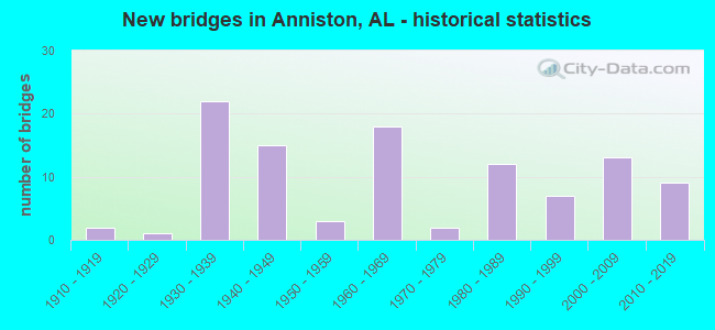
- New bridges - historical statistics
- 21910-1919
- 11920-1929
- 221930-1939
- 151940-1949
- 31950-1959
- 181960-1969
- 21970-1979
- 121980-1989
- 71990-1999
- 132000-2009
- 92010-2019
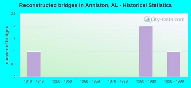
- Reconstructed bridges - Historical Statistics
- 11940-1949
- 01950-1959
- 01960-1969
- 01970-1979
- 21980-1989
- 11990-1999
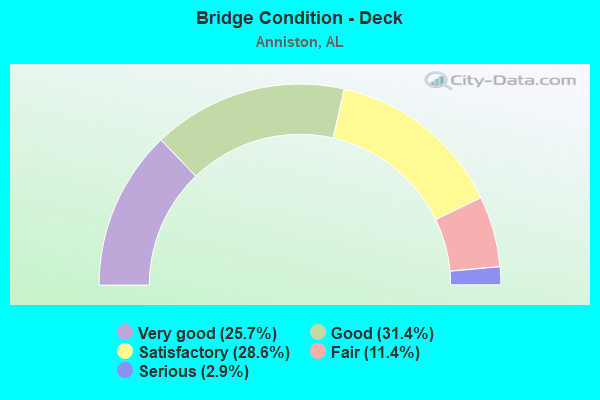
- Bridge Condition - Deck
- 25.7%Very good
- 31.4%Good
- 28.6%Satisfactory
- 11.4%Fair
- 2.9%Serious
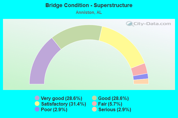
- Bridge Condition - Superstructure
- 28.6%Very good
- 28.6%Good
- 31.4%Satisfactory
- 5.7%Fair
- 2.9%Poor
- 2.9%Serious
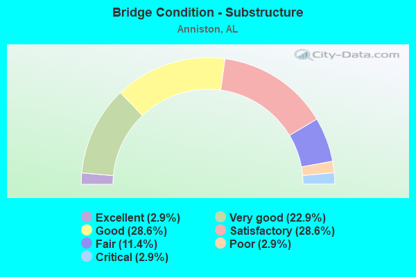
- Bridge Condition - Substructure
- 2.9%Excellent
- 22.9%Very good
- 28.6%Good
- 28.6%Satisfactory
- 11.4%Fair
- 2.9%Poor
- 2.9%Critical
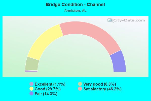
- Bridge Condition - Channel
- 1.1%Excellent
- 8.8%Very good
- 29.7%Good
- 46.2%Satisfactory
- 14.3%Fair
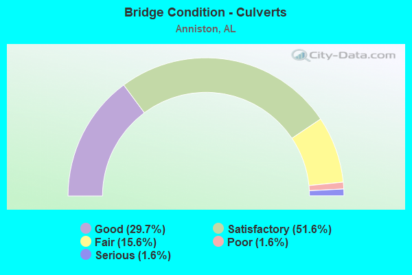
- Bridge Condition - Culverts
- 29.7%Good
- 51.6%Satisfactory
- 15.6%Fair
- 1.6%Poor
- 1.6%Serious
Find on map >> Show street view
Structure Number: 74, Location: ANNISTON E 17th Street (Lat: 33.666264, Lng: -85.849444), Route carried "on" structure: City street , Year Built: 1913, Status: Open, Structure Length: 0.70m (2.30ft), Average Daily Traffic: 580 (year 2021), Truck Traffic: 1%, Average Future Daily Traffic: 950 (year 2041), Design Load: H 15, Features Intersected: DRAINAGE DITCH, Facility Carried by Structure: EAST 17TH STREET
Minimum Vertical Clearance: 30+ m (98+ ft), Kilometerpoint: 0.100, Lanes on structure: 2, Owner: City or Municipal Highway Agency, Approaching Roadway Width: 7.9m (25.9ft), Skew: 4 degrees, Material/Design: Concrete, Design/Construction: Culvert, Number Of Spans In Main Unit: 2, Length of Maximum Span: 3.0m (9.8ft), Curb-To-Curb Width: 9.1m (29.9ft), Out-to-Out Width: 18.8m (61.7ft)
Condition: Channel: Good, Culverts: Satisfactory, Operating Rating: 43.5 metric tons, Method Used To Determine Operating Rating: Field evaluation and documented engineering judgment, Inventory Rating: 32.7 metric tons, Method Used To Determine Inventory Rating: Field evaluation and documented engineering judgment, Structural Evaluation: Equal to present minimum criteria, Deck Geometry: Equal to present minimum criteria, Waterway Adequacy: Better than present minimum criteria, Approach Roadway Alignment: Better than present minimum criteria, Length Of Structure Improvement: 1.34m (4.40ft), Designated Inspection Frequency: Every 24 months, Inspection Date: Febuary 2021, Bridge Improvement Cost: $696,000, Roadway Improvement Cost: $70,000, Total Project Cost: $766,000 ( Estimate for 2022), Deck Structure Type: Concrete Cast-file-Place, Wearing Surface/Protective System: Wearing Surface: Bituminous
Find on map >> Show street view
Structure Number: 87, Location: 1 MILE N HWY 78 (Lat: 33.895900, Lng: -87.496900), Route carried "on" structure: County highway , Year Built: 1915, Status: Closed, Structure Length: 4.30m (14.11ft), Average Daily Traffic: 125 (year 1991), Truck Traffic: 1%, Average Future Daily Traffic: 250 (year 2030), Design Load: H 15, Features Intersected: MILL CREEK, Facility Carried by Structure: SMITH CHAPEL RD
Minimum Vertical Clearance: 30+ m (98+ ft), Kilometerpoint: 0.010, Lanes on structure: 1, Owner: County Highway Agency, Approaching Roadway Width: 4.9m (16.1ft), Material/Design: Steel, Design/Construction: Truss - Thru, Number Of Spans In Main Unit: 1, Number Of Approach Spans: 4, Length of Maximum Span: 21.3m (69.9ft), Curb-To-Curb Width: 3.7m (12.1ft), Out-to-Out Width: 3.7m (12.1ft)
Condition: Deck: Fair, Superstructure: Poor, Substructure: Poor, Channel: Good, Waterway Adequacy: Equal to present desirable criteria, Approach Roadway Alignment: Somewhat better than minimum adequacy, Bridge Posting: Required (Relationship of Operating Rating to Maximum Legal Load: > 39.9% below), Length Of Structure Improvement: 5.27m (17.29ft), Designated Inspection Frequency: Every 24 months, Critical Feature Inspection Frequency: Every 12 months, Other Special Inspection Frequency: Every 12 months, Inspection Date: April 2013, Critical Feature Inspection Date: April 2013, Other Special Inspection Date: April 2013, Bridge Improvement Cost: $434,000, Roadway Improvement Cost: $43,000, Total Project Cost: $477,000 ( Estimate for 2022), Deck Structure Type: Corrugated Steel, Wearing Surface/Protective System: Wearing Surface: Gravel
Find on map >> Show street view
Structure Number: 1311, Location: 1.2 MI NE INT CHERO #97 (Lat: 34.308889, Lng: -85.509286), Route carried "on" structure: County highway 120, Year Built: 1935, Status: Posted for load, Structure Length: 0.61m (2.00ft), Average Daily Traffic: 80 (year 2020), Truck Traffic: 2%, Average Future Daily Traffic: 119 (year 2040), Design Load: H 15, Features Intersected: BRANCH
Minimum Vertical Clearance: 30+ m (98+ ft), Kilometerpoint: 0.010, Lanes on structure: 2, Owner: County Highway Agency, Approaching Roadway Width: 7.3m (24.0ft), Skew: 2 degrees, Material/Design: Steel, Design/Construction: Stringer/Multi-beam, Number Of Spans In Main Unit: 1, Length of Maximum Span: 6.1m (20.0ft), Curb-To-Curb Width: 6.0m (19.7ft), Out-to-Out Width: 6.8m (22.3ft)
Condition: Deck: Satisfactory, Superstructure: Satisfactory, Substructure: Satisfactory, Channel: Satisfactory, Operating Rating: 20.0 metric tons, Method Used To Determine Operating Rating: Allowable Stress (AS), Inventory Rating: 11.9 metric tons, Method Used To Determine Inventory Rating: Allowable Stress (AS), Structural Evaluation: Meets minimum limits, Deck Geometry: Meets minimum limits, Waterway Adequacy: Equal to present minimum criteria, Approach Roadway Alignment: Equal to present minimum criteria, Bridge Posting: Required (Relationship of Operating Rating to Maximum Legal Load: > 39.9% below), Length Of Structure Improvement: 1.22m (4.00ft), Designated Inspection Frequency: Every 24 months, Other Special Inspection Frequency: Every 12 months, Inspection Date: March 2021, Other Special Inspection Date: March 2021, Bridge Improvement Cost: $184,000, Roadway Improvement Cost: $18,000, Total Project Cost: $202,000 ( Estimate for 2022), Deck Structure Type: Concrete Cast-file-Place, Wearing Surface/Protective System: Wearing Surface: Bituminous
Find on map >> Show street view
Structure Number: 1409, Location: ANNISTON 7th Street (Lat: 33.653300, Lng: -85.837400), Route carried "on" structure: City street , Year Built: 1936, Status: Posted for load, Structure Length: 0.68m (2.23ft), Average Daily Traffic: 570 (year 2022), Truck Traffic: 1%, Average Future Daily Traffic: 750 (year 2042), Design Load: H 15, Features Intersected: DRAINAGE DITCH, Facility Carried by Structure: 7TH STREET
Minimum Vertical Clearance: 30+ m (98+ ft), Kilometerpoint: 0.100, Lanes on structure: 2, Owner: City or Municipal Highway Agency, Approaching Roadway Width: 6.1m (20.0ft), Material/Design: Concrete, Design/Construction: Slab, Number Of Spans In Main Unit: 1, Length of Maximum Span: 6.8m (22.3ft), Curb-To-Curb Width: 7.3m (24.0ft), Out-to-Out Width: 9.1m (29.9ft)
Condition: Deck: Fair, Superstructure: Satisfactory, Substructure: Fair, Channel: Satisfactory, Operating Rating: 13.6 metric tons, Method Used To Determine Operating Rating: Field evaluation and documented engineering judgment, Inventory Rating: 9.1 metric tons, Method Used To Determine Inventory Rating: Field evaluation and documented engineering judgment, Structural Evaluation: High priority of replacement, Deck Geometry: Meets minimum limits, Waterway Adequacy: Equal to present minimum criteria, Approach Roadway Alignment: Better than present minimum criteria, Bridge Posting: Required (Relationship of Operating Rating to Maximum Legal Load: > 39.9% below), Length Of Structure Improvement: 1.32m (4.33ft), Designated Inspection Frequency: Every 24 months, Other Special Inspection Frequency: Every 12 months, Inspection Date: Febuary 2021, Other Special Inspection Date: Febuary 2022, Bridge Improvement Cost: $262,000, Roadway Improvement Cost: $26,000, Total Project Cost: $288,000 ( Estimate for 2022)
Find on map >> Show street view
Structure Number: 1421, Location: ANNISTON 10th Street RR (Lat: 33.657061, Lng: -85.839453), Route carried "on" structure: City street , Year Built: 1936, Status: Open, Structure Length: 14.23m (46.69ft), Average Daily Traffic: 3,100 (year 2021), Truck Traffic: 2%, Average Future Daily Traffic: 4,600 (year 2041), Design Load: H 15, Features Intersected: SOU. RR ; CREEK, Facility Carried by Structure: 10TH STREET
Minimum Vertical Clearance: 30+ m (98+ ft), Kilometerpoint: 1.199, Lanes on structure: 2, Owner: City or Municipal Highway Agency, Approaching Roadway Width: 10.4m (34.1ft), Skew: 3 degrees, Material/Design: Concrete continuous, Design/Construction: Tee Beam, Number Of Spans In Main Unit: 1, Number Of Approach Spans: 12, Length of Maximum Span: 19.5m (64.0ft), Curb or Sidewalk Widths: Left: 0.3m (1.0ft), Right: 1.8m (5.9ft), Curb-To-Curb Width: 7.3m (24.0ft), Out-to-Out Width: 9.5m (31.2ft)
Condition: Deck: Satisfactory, Superstructure: Satisfactory, Substructure: Satisfactory, Channel: Fair, Operating Rating: 50.3 metric tons, Method Used To Determine Operating Rating: Load Factor (LF), Inventory Rating: 30.1 metric tons, Method Used To Determine Inventory Rating: Load Factor (LF), Structural Evaluation: Equal to present minimum criteria, Deck Geometry: High priority of replacement, Underclear: Meets minimum limits, Waterway Adequacy: Superior to present desirable criteria, Approach Roadway Alignment: Better than present minimum criteria, Length Of Structure Improvement: 15.02m (49.28ft), Designated Inspection Frequency: Every 24 months, Inspection Date: December 2021, Bridge Improvement Cost: $3,193,000, Roadway Improvement Cost: $319,000, Total Project Cost: $3,512,000 ( Estimate for 2022), Deck Structure Type: Concrete Cast-file-Place, Wearing Surface/Protective System: Wearing Surface: Bituminous
Find on map >> Show street view
Structure Number: 2035, Location: AL 77 * COOSA RIVER (Lat: 33.941958, Lng: -86.024942), Route carried "on" structure: State highway 77, Year Built: 1939, Status: Open, Structure Length: 26.46m (86.81ft), Average Daily Traffic: 10,161 (year 2019), Truck Traffic: 7%, Average Future Daily Traffic: 14,225 (year 2039), Design Load: H 15, Features Intersected: COOSA RIVER
Minimum Vertical Clearance: 4.24m (13.91ft), Kilometerpoint: 164.105, Lanes on structure: 2, Owner: State Highway Agency, Approaching Roadway Width: 6.9m (22.6ft), Material/Design: Steel, Design/Construction: Truss - Thru, Number Of Spans In Main Unit: 2, Number Of Approach Spans: 16, Length of Maximum Span: 61.6m (202.1ft), Curb-To-Curb Width: 6.0m (19.7ft), Out-to-Out Width: 6.4m (21.0ft)
Condition: Deck: Fair, Superstructure: Fair, Substructure: Satisfactory, Channel: Good, Operating Rating: 46.3 metric tons, Method Used To Determine Operating Rating: Load Factor (LF), Inventory Rating: 31.7 metric tons, Method Used To Determine Inventory Rating: Load Factor (LF), Structural Evaluation: Somewhat better than minimum adequacy, Deck Geometry: High priority of replacement, Waterway Adequacy: Equal to present desirable criteria, Approach Roadway Alignment: Somewhat better than minimum adequacy, Length Of Structure Improvement: 26.46m (86.81ft), Designated Inspection Frequency: Every 24 months, Critical Feature Inspection Frequency: Every 24 months, Underwater Inspection Frequency: Every 24 months, Inspection Date: July 2021, Critical Feature Inspection Date: July 2021, Underwater Inspection Date: July 2021, Bridge Improvement Cost: $3,810,000, Roadway Improvement Cost: $381,000, Total Project Cost: $4,191,000 ( Estimate for 2022), Deck Structure Type: Concrete Cast-file-Place
Find on map >> Show street view
Structure Number: 2044, Location: 0.7 N JCT CO RD 016 (Lat: 34.719139, Lng: -86.706436), Route carried "on" structure: County highway 88, Year Built: 1939, Status: Open, Structure Length: 0.85m (2.79ft), Average Daily Traffic: 1,241 (year 1987), Truck Traffic: 1%, Average Future Daily Traffic: 1,990 (year 2035), Design Load: H 15, Features Intersected: COON CREEK, Facility Carried by Structure: SLAUGHTER RD
Minimum Vertical Clearance: 30+ m (98+ ft), Kilometerpoint: 0.010, Lanes on structure: 2, Owner: County Highway Agency, Approaching Roadway Width: 9.1m (29.9ft), Material/Design: Masonry, Design/Construction: Culvert, Number Of Spans In Main Unit: 2, Length of Maximum Span: 4.3m (14.1ft), Curb-To-Curb Width: 8.0m (26.2ft), Out-to-Out Width: 8.6m (28.2ft)
Condition: Channel: Satisfactory, Culverts: Satisfactory, Operating Rating: 43.5 metric tons, Method Used To Determine Operating Rating: Field evaluation and documented engineering judgment, Inventory Rating: 32.7 metric tons, Method Used To Determine Inventory Rating: Field evaluation and documented engineering judgment, Structural Evaluation: Equal to present minimum criteria, Deck Geometry: Meets minimum limits, Waterway Adequacy: Equal to present minimum criteria, Approach Roadway Alignment: Equal to present minimum criteria, Length Of Structure Improvement: 1.51m (4.95ft), Designated Inspection Frequency: Every 24 months, Inspection Date: October 2020, Bridge Improvement Cost: $262,000, Roadway Improvement Cost: $26,000, Total Project Cost: $288,000 ( Estimate for 2022)
Find on map >> Show street view
Structure Number: 3154, Location: 4.4 MI N JCT US 431 (Lat: 33.738836, Lng: -85.794036), Route carried "on" structure: State highway 21, Year Built: 1926, Year Reconstructed: 1948, Status: Open, Structure Length: 0.95m (3.12ft), Average Daily Traffic: 19,402 (year 2020), Truck Traffic: 3%, Average Future Daily Traffic: 27,163 (year 2040), Design Load: H 15, Features Intersected: CAVE CREEK
Minimum Vertical Clearance: 30+ m (98+ ft), Kilometerpoint: 420.153, Lanes on structure: 4, Base Highway Network: Yes, Owner: State Highway Agency, Approaching Roadway Width: 22.0m (72.2ft), Skew: 12 degrees, Material/Design: Concrete, Design/Construction: Culvert, Number Of Spans In Main Unit: 3, Length of Maximum Span: 3.0m (9.8ft)
Condition: Channel: Good, Culverts: Fair, Operating Rating: 88.9 metric tons, Method Used To Determine Operating Rating: Load Factor (LF), Inventory Rating: 66.9 metric tons, Method Used To Determine Inventory Rating: Load Factor (LF), Structural Evaluation: Somewhat better than minimum adequacy, Waterway Adequacy: Equal to present minimum criteria, Approach Roadway Alignment: Equal to present desirable criteria, Length Of Structure Improvement: 1.62m (5.31ft), Designated Inspection Frequency: Every 24 months, Inspection Date: October 2021, Bridge Improvement Cost: $1,321,000, Roadway Improvement Cost: $132,000, Total Project Cost: $1,453,000 ( Estimate for 2022)
Find on map >> Show street view
Structure Number: 3227, Location: 2.5 MI N JCT US 431 (Lat: 33.726833, Lng: -85.809167), Route carried "on" structure: State highway 21, Year Built: 1948, Status: Open, Structure Length: 4.85m (15.91ft), Average Daily Traffic: 11,767 (year 2020), Truck Traffic: 3%, Average Future Daily Traffic: 16,475 (year 2040), Design Load: H 20, Features Intersected: CANE CREEK
Minimum Vertical Clearance: 30+ m (98+ ft), Kilometerpoint: 417.968, Lanes on structure: 2, Base Highway Network: Yes, Owner: State Highway Agency, Approaching Roadway Width: 11.0m (36.1ft), Skew: 16 degrees, Material/Design: Concrete, Design/Construction: Culvert, Number Of Spans In Main Unit: 5, Length of Maximum Span: 9.4m (30.8ft)
Condition: Channel: Satisfactory, Culverts: Fair, Operating Rating: 37.4 metric tons, Method Used To Determine Operating Rating: Load Factor (LF), Inventory Rating: 22.4 metric tons, Method Used To Determine Inventory Rating: Load Factor (LF), Structural Evaluation: Somewhat better than minimum adequacy, Waterway Adequacy: Equal to present minimum criteria, Approach Roadway Alignment: Equal to present desirable criteria, Length Of Structure Improvement: 5.86m (19.23ft), Designated Inspection Frequency: Every 24 months, Inspection Date: October 2021, Bridge Improvement Cost: $2,840,000, Roadway Improvement Cost: $284,000, Total Project Cost: $3,124,000 ( Estimate for 2022)
Find on map >> Show street view
Structure Number: 3228, Location: 5.4 MI N JCT US 431 (Lat: 33.752278, Lng: -85.787611), Route carried "on" structure: State highway 21, Year Built: 1948, Status: Open, Structure Length: 1.95m (6.40ft), Average Daily Traffic: 22,600 (year 2020), Truck Traffic: 3%, Average Future Daily Traffic: 31,640 (year 2040), Design Load: H 15, Features Intersected: DOTHARD CREEK
Minimum Vertical Clearance: 30+ m (98+ ft), Kilometerpoint: 421.841, Lanes on structure: 4, Base Highway Network: Yes, Owner: State Highway Agency, Approaching Roadway Width: 22.0m (72.2ft), Skew: 12 degrees, Material/Design: Concrete, Design/Construction: Culvert, Number Of Spans In Main Unit: 5, Length of Maximum Span: 3.8m (12.5ft)
Condition: Channel: Satisfactory, Culverts: Satisfactory, Operating Rating: 42.8 metric tons, Method Used To Determine Operating Rating: Load Factor (LF), Inventory Rating: 25.7 metric tons, Method Used To Determine Inventory Rating: Load Factor (LF), Structural Evaluation: Equal to present minimum criteria, Waterway Adequacy: Equal to present minimum criteria, Approach Roadway Alignment: Equal to present desirable criteria, Length Of Structure Improvement: 2.70m (8.86ft), Designated Inspection Frequency: Every 24 months, Inspection Date: October 2021, Bridge Improvement Cost: $2,179,000, Roadway Improvement Cost: $218,000, Total Project Cost: $2,397,000 ( Estimate for 2022)
Find on map >> Show street view
Structure Number: 4277, Location: 2.3 MI WEST JCT SR 21 (Lat: 33.597472, Lng: -85.866194), Route carried "on" structure: Bypass US 78, Year Built: 1952, Status: Open, Structure Length: 1.46m (4.79ft), Average Daily Traffic: 10,748 (year 2020), Truck Traffic: 7%, Average Future Daily Traffic: 15,047 (year 2040), Design Load: H 15, Features Intersected: SNOW CREEK
Minimum Vertical Clearance: 30+ m (98+ ft), Kilometerpoint: 254.196, Lanes on structure: 3, Owner: State Highway Agency, Approaching Roadway Width: 12.9m (42.3ft), Skew: 3 degrees, Material/Design: Concrete, Design/Construction: Culvert, Number Of Spans In Main Unit: 4, Length of Maximum Span: 3.5m (11.5ft)
Condition: Channel: Fair, Culverts: Satisfactory, Operating Rating: 63.0 metric tons, Method Used To Determine Operating Rating: Load Factor (LF), Inventory Rating: 37.7 metric tons, Method Used To Determine Inventory Rating: Load Factor (LF), Structural Evaluation: Equal to present minimum criteria, Waterway Adequacy: Equal to present minimum criteria, Approach Roadway Alignment: Equal to present desirable criteria, Length Of Structure Improvement: 2.14m (7.02ft), Designated Inspection Frequency: Every 24 months, Inspection Date: August 2021, Bridge Improvement Cost: $728,000, Roadway Improvement Cost: $73,000, Total Project Cost: $801,000 ( Estimate for 2022)
Find on map >> Show street view
Structure Number: 5447, Location: ANNISTON Glen Addie Ave (Lat: 33.652025, Lng: -85.836150), Route carried "on" structure: City street , Year Built: 1956, Status: Open, Structure Length: 0.96m (3.15ft), Average Daily Traffic: 725 (year 2021), Truck Traffic: 1%, Average Future Daily Traffic: 1,000 (year 2041), Design Load: H 15, Features Intersected: DRAINAGE DITCH, Facility Carried by Structure: GLEN ADDIE AVE
Minimum Vertical Clearance: 30+ m (98+ ft), Kilometerpoint: 0.299, Lanes on structure: 2, Owner: City or Municipal Highway Agency, Approaching Roadway Width: 7.3m (24.0ft), Skew: 3 degrees, Material/Design: Concrete, Design/Construction: Slab, Number Of Spans In Main Unit: 2, Length of Maximum Span: 4.3m (14.1ft), Curb or Sidewalk Widths: Left: 4.3m (14.1ft), Right: 4.3m (14.1ft), Curb-To-Curb Width: 8.5m (27.9ft), Out-to-Out Width: 17.6m (57.7ft)
Condition: Deck: Satisfactory, Superstructure: Good, Substructure: Satisfactory, Channel: Fair, Operating Rating: 43.5 metric tons, Method Used To Determine Operating Rating: Field evaluation and documented engineering judgment, Inventory Rating: 32.7 metric tons, Method Used To Determine Inventory Rating: Field evaluation and documented engineering judgment, Structural Evaluation: Equal to present minimum criteria, Deck Geometry: Somewhat better than minimum adequacy, Waterway Adequacy: Equal to present minimum criteria, Approach Roadway Alignment: Better than present minimum criteria, Length Of Structure Improvement: 1.63m (5.35ft), Designated Inspection Frequency: Every 24 months, Inspection Date: Febuary 2021, Bridge Improvement Cost: $636,000, Roadway Improvement Cost: $64,000, Total Project Cost: $700,000 ( Estimate for 2022)
Find on map >> Show street view
Structure Number: 6525, Location: CITY OF ANNISTON (Lat: 33.642400, Lng: -85.825900), Route carried "on" structure: State highway 21, Year Built: 1959, Status: Open, Structure Length: 0.86m (2.82ft), Average Daily Traffic: 34,670 (year 2019), Truck Traffic: 5%, Average Future Daily Traffic: 48,538 (year 2039), Design Load: HS 20, Features Intersected: BRANCH
Minimum Vertical Clearance: 30+ m (98+ ft), Kilometerpoint: 408.065, Lanes on structure: 7, Base Highway Network: Yes, Owner: State Highway Agency, Approaching Roadway Width: 23.8m (78.1ft), Skew: 23 degrees, Material/Design: Concrete, Design/Construction: Culvert, Number Of Spans In Main Unit: 2, Length of Maximum Span: 3.7m (12.1ft)
Condition: Channel: Good, Culverts: Fair, Operating Rating: 48.2 metric tons, Method Used To Determine Operating Rating: Load Factor (LF), Inventory Rating: 28.9 metric tons, Method Used To Determine Inventory Rating: Load Factor (LF), Structural Evaluation: Somewhat better than minimum adequacy, Waterway Adequacy: Equal to present minimum criteria, Approach Roadway Alignment: Equal to present desirable criteria, Length Of Structure Improvement: 1.53m (5.02ft), Designated Inspection Frequency: Every 24 months, Inspection Date: June 2021, Bridge Improvement Cost: $1,121,000, Roadway Improvement Cost: $112,000, Total Project Cost: $1,233,000 ( Estimate for 2022)
Find on map >> Show street view
Structure Number: 6896, Location: 0.5 MI N OLD US 431 (Lat: 33.730247, Lng: -85.878486), Route carried "on" structure: US 431, Year Built: 1960, Status: Open, Structure Length: 1.60m (5.25ft), Average Daily Traffic: 20,256 (year 2020), Truck Traffic: 8%, Average Future Daily Traffic: 28,358 (year 2040), Design Load: H 15, Features Intersected: BRANCH
Minimum Vertical Clearance: 30+ m (98+ ft), Kilometerpoint: 380.723, Lanes on structure: 4, Base Highway Network: Yes, Owner: State Highway Agency, Approaching Roadway Width: 22.2m (72.8ft), Skew: 10 degrees, Material/Design: Concrete, Design/Construction: Culvert, Number Of Spans In Main Unit: 5, Length of Maximum Span: 3.0m (9.8ft)
Condition: Channel: Good, Culverts: Satisfactory, Operating Rating: 73.6 metric tons, Method Used To Determine Operating Rating: Load Factor (LF), Inventory Rating: 72.6 metric tons, Method Used To Determine Inventory Rating: Load Factor (LF), Structural Evaluation: Equal to present minimum criteria, Waterway Adequacy: Equal to present minimum criteria, Approach Roadway Alignment: Equal to present desirable criteria, Length Of Structure Improvement: 2.29m (7.51ft), Designated Inspection Frequency: Every 24 months, Inspection Date: October 2021, Bridge Improvement Cost: $1,782,000, Roadway Improvement Cost: $178,000, Total Project Cost: $1,960,000 ( Estimate for 2022)
Find on map >> Show street view
Structure Number: 7609, Location: JCT OLD US431 / SR21 (Lat: 33.694722, Lng: -85.823361), Route carried "on" structure: State highway 21, Year Built: 1962, Status: Open, Structure Length: 0.62m (2.03ft), Average Daily Traffic: 34,484 (year 2020), Truck Traffic: 5%, Average Future Daily Traffic: 48,278 (year 2040), Design Load: HS 20, Features Intersected: SNOW CREEK
Minimum Vertical Clearance: 30+ m (98+ ft), Kilometerpoint: 413.843, Lanes on structure: 7, Base Highway Network: Yes, Owner: State Highway Agency, Approaching Roadway Width: 33.9m (111.2ft), Skew: 23 degrees, Material/Design: Concrete, Design/Construction: Culvert, Number Of Spans In Main Unit: 2, Length of Maximum Span: 2.8m (9.2ft)
Condition: Channel: Fair, Culverts: Fair, Operating Rating: 58.3 metric tons, Method Used To Determine Operating Rating: Load Factor (LF), Inventory Rating: 35.0 metric tons, Method Used To Determine Inventory Rating: Load Factor (LF), Structural Evaluation: Somewhat better than minimum adequacy, Waterway Adequacy: Equal to present minimum criteria, Approach Roadway Alignment: Equal to present desirable criteria, Length Of Structure Improvement: 1.24m (4.07ft), Designated Inspection Frequency: Every 24 months, Inspection Date: October 2021, Bridge Improvement Cost: $1,507,000, Roadway Improvement Cost: $151,000, Total Project Cost: $1,658,000 ( Estimate for 2022)
Find on map >> Show street view
Structure Number: 7683, Location: 2.5 MI N JCT SR 21 (Lat: 33.726664, Lng: -85.808669), Route carried "on" structure: State highway 21, Year Built: 1962, Status: Open, Structure Length: 4.85m (15.91ft), Average Daily Traffic: 11,767 (year 2020), Truck Traffic: 3%, Average Future Daily Traffic: 16,475 (year 2040), Design Load: H 20, Features Intersected: CANE CREEK
Minimum Vertical Clearance: 30+ m (98+ ft), Kilometerpoint: 417.968, Lanes on structure: 2, Base Highway Network: Yes, Owner: State Highway Agency, Approaching Roadway Width: 11.0m (36.1ft), Skew: 16 degrees, Material/Design: Concrete, Design/Construction: Culvert, Number Of Spans In Main Unit: 5, Length of Maximum Span: 9.4m (30.8ft)
Condition: Channel: Satisfactory, Culverts: Fair, Operating Rating: 48.6 metric tons, Method Used To Determine Operating Rating: Load Factor (LF), Inventory Rating: 29.1 metric tons, Method Used To Determine Inventory Rating: Load Factor (LF), Structural Evaluation: Somewhat better than minimum adequacy, Waterway Adequacy: Equal to present minimum criteria, Approach Roadway Alignment: Equal to present desirable criteria, Length Of Structure Improvement: 5.86m (19.23ft), Designated Inspection Frequency: Every 24 months, Inspection Date: October 2021, Bridge Improvement Cost: $3,348,000, Roadway Improvement Cost: $335,000, Total Project Cost: $3,683,000 ( Estimate for 2022)
Find on map >> Show street view
Structure Number: 8645, Location: ANNISTON McDaniel Ave (Lat: 33.660981, Lng: -85.847342), Route carried "on" structure: City street , Year Built: 1965, Status: Open, Structure Length: 1.34m (4.40ft), Average Daily Traffic: 625 (year 2021), Truck Traffic: 1%, Average Future Daily Traffic: 1,000 (year 2041), Design Load: H 15, Features Intersected: DRAINAGE DITCH, Facility Carried by Structure: MCDANIEL AVE.
Minimum Vertical Clearance: 30+ m (98+ ft), Kilometerpoint: 0.200, Lanes on structure: 2, Owner: City or Municipal Highway Agency, Approaching Roadway Width: 6.1m (20.0ft), Skew: 3 degrees, Material/Design: Concrete, Design/Construction: Culvert, Number Of Spans In Main Unit: 2, Length of Maximum Span: 6.4m (21.0ft), Curb-To-Curb Width: 8.2m (26.9ft), Out-to-Out Width: 8.5m (27.9ft)
Condition: Channel: Satisfactory, Culverts: Satisfactory, Operating Rating: 32.7 metric tons, Method Used To Determine Operating Rating: Field evaluation and documented engineering judgment, Inventory Rating: 23.6 metric tons, Method Used To Determine Inventory Rating: Field evaluation and documented engineering judgment, Structural Evaluation: Equal to present minimum criteria, Deck Geometry: Somewhat better than minimum adequacy, Waterway Adequacy: Better than present minimum criteria, Approach Roadway Alignment: Equal to present minimum criteria, Length Of Structure Improvement: 2.02m (6.63ft), Designated Inspection Frequency: Every 24 months, Inspection Date: Febuary 2021, Bridge Improvement Cost: $326,000, Roadway Improvement Cost: $33,000, Total Project Cost: $359,000 ( Estimate for 2022), Wearing Surface/Protective System: Wearing Surface: Bituminous
Find on map >> Show street view
Structure Number: 8655, Location: 2 MI E OF AL 21 (Lat: 33.629264, Lng: -85.799600), Route carried "on" structure: City street , Year Built: 1965, Status: Open, Structure Length: 0.62m (2.03ft), Average Daily Traffic: 4,500 (year 2021), Truck Traffic: 5%, Average Future Daily Traffic: 5,500 (year 2041), Design Load: H 15, Features Intersected: BRANCH, Facility Carried by Structure: GREENBRIAR DR
Minimum Vertical Clearance: 30+ m (98+ ft), Kilometerpoint: 1.999, Lanes on structure: 2, Owner: City or Municipal Highway Agency, Approaching Roadway Width: 13.4m (44.0ft), Skew: 3 degrees, Material/Design: Concrete, Design/Construction: Culvert, Number Of Spans In Main Unit: 2, Length of Maximum Span: 2.8m (9.2ft)
Condition: Channel: Satisfactory, Culverts: Satisfactory, Operating Rating: 88.9 metric tons, Method Used To Determine Operating Rating: Load Factor (LF), Inventory Rating: 77.7 metric tons, Method Used To Determine Inventory Rating: Load Factor (LF), Structural Evaluation: Equal to present minimum criteria, Waterway Adequacy: Better than present minimum criteria, Approach Roadway Alignment: Equal to present minimum criteria, Length Of Structure Improvement: 1.24m (4.07ft), Designated Inspection Frequency: Every 24 months, Inspection Date: Febuary 2021, Bridge Improvement Cost: $696,000, Roadway Improvement Cost: $70,000, Total Project Cost: $766,000 ( Estimate for 2022)
Find on map >> Show street view
Structure Number: 8689, Location: ANN W 11th & McDaniel (Lat: 33.658811, Lng: -85.844833), Route carried "on" structure: City street , Year Built: 1965, Status: Open, Structure Length: 1.11m (3.64ft), Average Daily Traffic: 1,100 (year 2021), Truck Traffic: 1%, Average Future Daily Traffic: 1,700 (year 2041), Design Load: H 15, Features Intersected: DRAINAGE DITCH, Facility Carried by Structure: W11TH*MCDANIEL
Minimum Vertical Clearance: 30+ m (98+ ft), Kilometerpoint: 0.499, Lanes on structure: 2, Owner: City or Municipal Highway Agency, Approaching Roadway Width: 8.8m (28.9ft), Skew: 4 degrees, Material/Design: Concrete, Design/Construction: Culvert, Number Of Spans In Main Unit: 2, Length of Maximum Span: 5.3m (17.4ft), Curb-To-Curb Width: 13.3m (43.6ft), Out-to-Out Width: 13.8m (45.3ft)
Condition: Channel: Satisfactory, Culverts: Good, Operating Rating: 40.9 metric tons, Method Used To Determine Operating Rating: Load Factor (LF), Inventory Rating: 24.6 metric tons, Method Used To Determine Inventory Rating: Load Factor (LF), Structural Evaluation: Equal to present minimum criteria, Deck Geometry: Better than present minimum criteria, Waterway Adequacy: Equal to present minimum criteria, Approach Roadway Alignment: Better than present minimum criteria, Length Of Structure Improvement: 1.78m (5.84ft), Designated Inspection Frequency: Every 24 months, Inspection Date: Febuary 2021, Bridge Improvement Cost: $659,000, Roadway Improvement Cost: $66,000, Total Project Cost: $725,000 ( Estimate for 2022)
Find on map >> Show street view
Structure Number: 87, Location: ANNISTON W 12th Street (Lat: 33.659731, Lng: -85.832675), Route carried "on" structure: City street , Year Built: 1965, Status: Open, Structure Length: 0.78m (2.56ft), Average Daily Traffic: 700 (year 2021), Truck Traffic: 1%, Average Future Daily Traffic: 950 (year 2041), Design Load: H 15, Features Intersected: CREEK, Facility Carried by Structure: W 12TH ST
Minimum Vertical Clearance: 30+ m (98+ ft), Kilometerpoint: 0.499, Lanes on structure: 2, Owner: City or Municipal Highway Agency, Approaching Roadway Width: 8.3m (27.2ft), Skew: 4 degrees, Material/Design: Concrete, Design/Construction: Culvert, Number Of Spans In Main Unit: 2, Length of Maximum Span: 4.6m (15.1ft), Curb or Sidewalk Widths: Left: 0.0m, Right: 2.8m (9.2ft), Curb-To-Curb Width: 9.2m (30.2ft), Out-to-Out Width: 12.4m (40.7ft)
Condition: Channel: Fair, Culverts: Satisfactory, Operating Rating: 32.7 metric tons, Method Used To Determine Operating Rating: Field evaluation and documented engineering judgment, Inventory Rating: 23.6 metric tons, Method Used To Determine Inventory Rating: Field evaluation and documented engineering judgment, Structural Evaluation: Equal to present minimum criteria, Deck Geometry: Equal to present minimum criteria, Waterway Adequacy: Equal to present minimum criteria, Approach Roadway Alignment: Equal to present minimum criteria, Length Of Structure Improvement: 1.44m (4.72ft), Designated Inspection Frequency: Every 24 months, Inspection Date: Febuary 2021, Bridge Improvement Cost: $399,000, Roadway Improvement Cost: $40,000, Total Project Cost: $439,000 ( Estimate for 2022), Wearing Surface/Protective System: Wearing Surface: Bituminous
Find on map >> Show street view
Structure Number: 9862, Location: 3 MI E JCT SR 21 (Lat: 33.611478, Lng: -85.779072), Route carried "on" structure: Interstate 20, Year Built: 1969, Status: Open, Structure Length: 1.30m (4.27ft), Average Daily Traffic: 20,519 (year 2018), Truck Traffic: 40%, Average Future Daily Traffic: 28,727 (year 2038), Design Load: HS 20, Features Intersected: BRANCH
Minimum Vertical Clearance: 30+ m (98+ ft), Kilometerpoint: 303.516, Lanes on structure: 3, Base Highway Network: Yes, Owner: State Highway Agency, Approaching Roadway Width: 15.3m (50.2ft), Skew: 13 degrees, Material/Design: Concrete, Design/Construction: Culvert, Number Of Spans In Main Unit: 3, Length of Maximum Span: 4.2m (13.8ft)
Condition: Channel: Good, Culverts: Satisfactory, Operating Rating: 50.1 metric tons, Method Used To Determine Operating Rating: Load Factor (LF), Inventory Rating: 30.0 metric tons, Method Used To Determine Inventory Rating: Load Factor (LF), Structural Evaluation: Equal to present minimum criteria, Waterway Adequacy: Equal to present minimum criteria, Approach Roadway Alignment: Equal to present desirable criteria, Length Of Structure Improvement: 1.98m (6.50ft), Designated Inspection Frequency: Every 24 months, Inspection Date: November 2021, Bridge Improvement Cost: $1,095,000, Roadway Improvement Cost: $110,000, Total Project Cost: $1,205,000 ( Estimate for 2022)
Find on map >> Show street view
Structure Number: 9864, Location: 3.3 MI E JCT SR 21 (Lat: 33.611047, Lng: -85.773736), Route carried "on" structure: Interstate 20, Year Built: 1969, Status: Open, Structure Length: 3.35m (10.99ft), Average Daily Traffic: 19,747 (year 2020), Truck Traffic: 40%, Average Future Daily Traffic: 27,645 (year 2040), Design Load: HS 20, Features Intersected: BRANCH
Minimum Vertical Clearance: 30+ m (98+ ft), Kilometerpoint: 303.975, Lanes on structure: 2, Base Highway Network: Yes, Owner: State Highway Agency, Approaching Roadway Width: 11.6m (38.1ft), Skew: 4 degrees, Material/Design: Concrete, Design/Construction: Culvert, Number Of Spans In Main Unit: 5, Length of Maximum Span: 6.2m (20.3ft)
Condition: Channel: Satisfactory, Culverts: Satisfactory, Operating Rating: 73.9 metric tons, Method Used To Determine Operating Rating: Load Factor (LF), Inventory Rating: 44.3 metric tons, Method Used To Determine Inventory Rating: Load Factor (LF), Structural Evaluation: Equal to present minimum criteria, Waterway Adequacy: Equal to present minimum criteria, Approach Roadway Alignment: Equal to present desirable criteria, Length Of Structure Improvement: 4.24m (13.91ft), Designated Inspection Frequency: Every 24 months, Inspection Date: November 2021, Bridge Improvement Cost: $2,741,000, Roadway Improvement Cost: $274,000, Total Project Cost: $3,015,000 ( Estimate for 2022)
Find on map >> Show street view
Structure Number: 9953, Location: CITY OF ANNISTON (Lat: 33.663706, Lng: -85.826756), Route carried "on" structure: State highway 21, Year Built: 1969, Status: Open, Structure Length: 0.78m (2.56ft), Average Daily Traffic: 36,424 (year 2020), Truck Traffic: 3%, Average Future Daily Traffic: 50,994 (year 2040), Design Load: H 15, Features Intersected: SNOW CREEK
Minimum Vertical Clearance: 30+ m (98+ ft), Kilometerpoint: 410.301, Lanes on structure: 6, Base Highway Network: Yes, Owner: State Highway Agency, Approaching Roadway Width: 22.6m (74.1ft), Skew: 24 degrees, Material/Design: Concrete, Design/Construction: Culvert, Number Of Spans In Main Unit: 2, Length of Maximum Span: 3.8m (12.5ft)
Condition: Channel: Good, Culverts: Fair, Operating Rating: 33.3 metric tons, Method Used To Determine Operating Rating: Load Factor (LF), Inventory Rating: 20.0 metric tons, Method Used To Determine Inventory Rating: Load Factor (LF), Structural Evaluation: Somewhat better than minimum adequacy, Waterway Adequacy: Equal to present minimum criteria, Approach Roadway Alignment: Equal to present desirable criteria, Length Of Structure Improvement: 1.43m (4.69ft), Designated Inspection Frequency: Every 24 months, Inspection Date: November 2021, Bridge Improvement Cost: $1,401,000, Roadway Improvement Cost: $140,000, Total Project Cost: $1,541,000 ( Estimate for 2022)
Find on map >> Show street view
Structure Number: 12797, Location: BYNUM-LEATH RD (Lat: 33.644178, Lng: -85.909431), Route carried "on" structure: County highway 47, Year Built: 1982, Status: Open, Structure Length: 1.89m (6.20ft), Average Daily Traffic: 10,087 (year 2016), Truck Traffic: 10%, Average Future Daily Traffic: 16,224 (year 2040), Design Load: H 15, Features Intersected: BRANCH, Facility Carried by Structure: BYNUM-LEATH RD.
Minimum Vertical Clearance: 30+ m (98+ ft), Kilometerpoint: 0.000, Lanes on structure: 2, Owner: County Highway Agency, Approaching Roadway Width: 13.4m (44.0ft), Skew: 3 degrees, Material/Design: Concrete, Design/Construction: Culvert, Number Of Spans In Main Unit: 5, Length of Maximum Span: 3.0m (9.8ft)
Condition: Channel: Good, Culverts: Fair, Operating Rating: 88.9 metric tons, Method Used To Determine Operating Rating: Load Factor (LF), Inventory Rating: 88.9 metric tons, Method Used To Determine Inventory Rating: Load Factor (LF), Structural Evaluation: Somewhat better than minimum adequacy, Waterway Adequacy: Equal to present desirable criteria, Approach Roadway Alignment: Better than present minimum criteria, Length Of Structure Improvement: 2.62m (8.60ft), Designated Inspection Frequency: Every 24 months, Inspection Date: November 2020, Bridge Improvement Cost: $3,852,000, Roadway Improvement Cost: $385,000, Total Project Cost: $4,237,000 ( Estimate for 2022), Wearing Surface/Protective System: Wearing Surface: Bituminous
Find on map >> Show street view
Structure Number: 12798, Location: BYNUM LEATHERWOOD (Lat: 33.645886, Lng: -85.909344), Route carried "on" structure: County highway 47, Year Built: 1982, Status: Open, Structure Length: 12.68m (41.60ft), Average Daily Traffic: 5,075 (year 1993), Truck Traffic: 3%, Average Future Daily Traffic: 6,700 (year 2036), Design Load: HS 20, Features Intersected: CO 072 * SCL RR, Facility Carried by Structure: BYNUM-LEATH RD.
Minimum Vertical Clearance: 30+ m (98+ ft), Kilometerpoint: 0.000, Lanes on structure: 2, Lanes under structure: 2, Owner: County Highway Agency, Approaching Roadway Width: 13.4m (44.0ft), Skew: 4 degrees, Material/Design: Steel continuous, Design/Construction: Stringer/Multi-beam, Number Of Spans In Main Unit: 1, Number Of Approach Spans: 4, Length of Maximum Span: 38.4m (126.0ft), Curb-To-Curb Width: 13.4m (44.0ft), Out-to-Out Width: 13.4m (44.0ft)
Condition: Deck: Satisfactory, Superstructure: Satisfactory, Substructure: Very good, Operating Rating: 57.9 metric tons, Method Used To Determine Operating Rating: Load Factor (LF), Inventory Rating: 34.7 metric tons, Method Used To Determine Inventory Rating: Load Factor (LF), Structural Evaluation: Equal to present minimum criteria, Deck Geometry: Equal to present minimum criteria, Underclear: High priority of corrective action, Approach Roadway Alignment: Equal to present desirable criteria, Length Of Structure Improvement: 13.51m (44.32ft), Designated Inspection Frequency: Every 24 months, Inspection Date: January 2021, Bridge Improvement Cost: $4,077,000, Roadway Improvement Cost: $408,000, Total Project Cost: $4,485,000 ( Estimate for 2022), Deck Structure Type: Concrete Cast-file-Place
Find on map >> Show street view
Structure Number: 12812, Location: BYNUM EXIT (Lat: 33.646336, Lng: -85.908836), Route carried "on" structure: County highway 72, Year Built: 1982, Status: Open, Structure Length: 7.25m (23.79ft), Average Daily Traffic: 4,057 (year 2019), Truck Traffic: 10%, Average Future Daily Traffic: 6,149 (year 2040), Design Load: HS 20, Features Intersected: BRANCH, Facility Carried by Structure: .9 MI N AL 202
Minimum Vertical Clearance: 30+ m (98+ ft), Kilometerpoint: 0.000, Lanes on structure: 3, Owner: County Highway Agency, Approaching Roadway Width: 15.8m (51.8ft), Skew: 4 degrees, Material/Design: Prestressed concrete, Design/Construction: Stringer/Multi-beam, Number Of Spans In Main Unit: 7, Length of Maximum Span: 10.4m (34.1ft), Curb-To-Curb Width: 15.8m (51.8ft), Out-to-Out Width: 15.8m (51.8ft)
Condition: Deck: Satisfactory, Superstructure: Satisfactory, Substructure: Very good, Channel: Satisfactory, Operating Rating: 56.3 metric tons, Method Used To Determine Operating Rating: Load Factor (LF), Inventory Rating: 34.7 metric tons, Method Used To Determine Inventory Rating: Load Factor (LF), Structural Evaluation: Equal to present minimum criteria, Deck Geometry: Better than present minimum criteria, Waterway Adequacy: Equal to present desirable criteria, Approach Roadway Alignment: Better than present minimum criteria, Length Of Structure Improvement: 8.28m (27.17ft), Designated Inspection Frequency: Every 24 months, Inspection Date: December 2020, Bridge Improvement Cost: $2,895,000, Roadway Improvement Cost: $290,000, Total Project Cost: $3,185,000 ( Estimate for 2022), Deck Structure Type: Concrete Cast-file-Place
Find on map >> Show street view
Structure Number: 12947, Location: ANNISTON "F" Street (Lat: 33.641864, Lng: -85.822078), Route carried "on" structure: City street , Year Built: 1983, Status: Open, Structure Length: 1.37m (4.49ft), Average Daily Traffic: 1,200 (year 2021), Truck Traffic: 1%, Average Future Daily Traffic: 1,200 (year 2041), Design Load: HS 20, Features Intersected: CREEK, Facility Carried by Structure: "F" STREET
Minimum Vertical Clearance: 30+ m (98+ ft), Kilometerpoint: 0.100, Lanes on structure: 2, Owner: City or Municipal Highway Agency, Approaching Roadway Width: 8.5m (27.9ft), Material/Design: Concrete, Design/Construction: Channel Beam, Number Of Spans In Main Unit: 1, Length of Maximum Span: 13.7m (44.9ft), Curb or Sidewalk Widths: Left: 0.3m (1.0ft), Right: 0.3m (1.0ft), Curb-To-Curb Width: 8.5m (27.9ft), Out-to-Out Width: 9.0m (29.5ft)
Condition: Deck: Satisfactory, Superstructure: Good, Substructure: Good, Channel: Satisfactory, Operating Rating: 74.7 metric tons, Method Used To Determine Operating Rating: Load Factor (LF), Inventory Rating: 44.8 metric tons, Method Used To Determine Inventory Rating: Load Factor (LF), Structural Evaluation: Better than present minimum criteria, Deck Geometry: Somewhat better than minimum adequacy, Waterway Adequacy: Equal to present minimum criteria, Approach Roadway Alignment: Equal to present minimum criteria, Length Of Structure Improvement: 2.04m (6.69ft), Designated Inspection Frequency: Every 24 months, Inspection Date: Febuary 2021, Bridge Improvement Cost: $406,000, Roadway Improvement Cost: $41,000, Total Project Cost: $447,000 ( Estimate for 2022), Deck Structure Type: Concrete Precast Panels
Find on map >> Show street view
Structure Number: 1311, Location: WEAVERRD.*LENLOCK DR. (Lat: 33.728214, Lng: -85.815275), Route carried "on" structure: City street , Year Built: 1984, Status: Open, Structure Length: 2.59m (8.50ft), Average Daily Traffic: 7,150 (year 2021), Truck Traffic: 1%, Average Future Daily Traffic: 10,000 (year 2041), Design Load: HS 20, Features Intersected: CANE CREEK, Facility Carried by Structure: Weaver Road
Minimum Vertical Clearance: 30+ m (98+ ft), Kilometerpoint: 1.099, Lanes on structure: 2, Owner: City or Municipal Highway Agency, Approaching Roadway Width: 7.6m (24.9ft), Skew: 4 degrees, Material/Design: Concrete, Design/Construction: Culvert, Number Of Spans In Main Unit: 4, Length of Maximum Span: 4.3m (14.1ft), Curb-To-Curb Width: 10.4m (34.1ft), Out-to-Out Width: 11.0m (36.1ft)
Condition: Channel: Satisfactory, Culverts: Good, Operating Rating: 80.6 metric tons, Method Used To Determine Operating Rating: Load Factor (LF), Inventory Rating: 48.4 metric tons, Method Used To Determine Inventory Rating: Load Factor (LF), Structural Evaluation: Better than present minimum criteria, Deck Geometry: Meets minimum limits, Waterway Adequacy: Equal to present desirable criteria, Approach Roadway Alignment: Equal to present minimum criteria, Length Of Structure Improvement: 3.49m (11.45ft), Designated Inspection Frequency: Every 24 months, Inspection Date: Febuary 2021, Bridge Improvement Cost: $1,008,000, Roadway Improvement Cost: $101,000, Total Project Cost: $1,109,000 ( Estimate for 2022), Deck Structure Type: Concrete Cast-file-Place
Find on map >> Show street view
Structure Number: 13397, Location: 8.47 MI E US 78 (Lat: 33.654472, Lng: -85.837292), Route carried "on" structure: State highway 202, Year Built: 1984, Status: Open, Structure Length: 1.72m (5.64ft), Average Daily Traffic: 13,586 (year 2020), Truck Traffic: 4%, Average Future Daily Traffic: 19,020 (year 2040), Design Load: HS 20, Features Intersected: STREAM
Minimum Vertical Clearance: 30+ m (98+ ft), Kilometerpoint: 13.631, Lanes on structure: 4, Base Highway Network: Yes, Owner: State Highway Agency, Approaching Roadway Width: 24.4m (80.1ft), Skew: 21 degrees, Material/Design: Concrete, Design/Construction: Culvert, Number Of Spans In Main Unit: 5, Length of Maximum Span: 3.2m (10.5ft)
Condition: Channel: Satisfactory, Culverts: Satisfactory, Operating Rating: 88.9 metric tons, Method Used To Determine Operating Rating: Load Factor (LF), Inventory Rating: 88.9 metric tons, Method Used To Determine Inventory Rating: Load Factor (LF), Structural Evaluation: Equal to present minimum criteria, Waterway Adequacy: Equal to present minimum criteria, Approach Roadway Alignment: Equal to present desirable criteria, Length Of Structure Improvement: 2.41m (7.91ft), Designated Inspection Frequency: Every 24 months, Inspection Date: January 2022, Bridge Improvement Cost: $4,179,000, Roadway Improvement Cost: $418,000, Total Project Cost: $4,597,000 ( Estimate for 2022)
Find on map >> Show street view
Structure Number: 13398, Location: 10.1 MI E US 78 (Lat: 33.654486, Lng: -85.836706), Route carried "on" structure: State highway 202, Year Built: 1984, Status: Open, Structure Length: 13.84m (45.41ft), Average Daily Traffic: 13,180 (year 2013), Truck Traffic: 4%, Average Future Daily Traffic: 16,764 (year 2033), Design Load: HS 20, Features Intersected: NFKSOU RR GLEN ADDIE AVE
Minimum Vertical Clearance: 30+ m (98+ ft), Kilometerpoint: 13.712, Lanes on structure: 4, Lanes under structure: 2, Owner: State Highway Agency, Approaching Roadway Width: 25.6m (84.0ft), Skew: 23 degrees, Material/Design: Steel continuous, Design/Construction: Stringer/Multi-beam, Number Of Spans In Main Unit: 4, Length of Maximum Span: 41.8m (137.1ft), Curb-To-Curb Width: 24.4m (80.1ft), Out-to-Out Width: 26.5m (86.9ft)
Condition: Deck: Satisfactory, Superstructure: Good, Substructure: Good, Operating Rating: 69.5 metric tons, Method Used To Determine Operating Rating: Load Factor (LF), Inventory Rating: 41.6 metric tons, Method Used To Determine Inventory Rating: Load Factor (LF), Structural Evaluation: Better than present minimum criteria, Deck Geometry: Superior to present desirable criteria, Underclear: Superior to present desirable criteria, Approach Roadway Alignment: Equal to present desirable criteria, Length Of Structure Improvement: 14.64m (48.03ft), Designated Inspection Frequency: Every 24 months, Inspection Date: March 2020, Bridge Improvement Cost: $8,634,000, Roadway Improvement Cost: $863,000, Total Project Cost: $9,497,000 ( Estimate for 2022), Deck Structure Type: Concrete Cast-file-Place
Find on map >> Show street view
Structure Number: 13399, Location: 10.3 MI E US 78 (Lat: 33.654503, Lng: -85.833303), Route carried "on" structure: State highway 202, Year Built: 1984, Status: Open, Structure Length: 9.91m (32.51ft), Average Daily Traffic: 14,818 (year 2018), Truck Traffic: 4%, Average Future Daily Traffic: 20,745 (year 2038), Design Load: HS 20, Features Intersected: ABANDONED R/R
Minimum Vertical Clearance: 30+ m (98+ ft), Kilometerpoint: 14.017, Lanes on structure: 4, Owner: State Highway Agency, Approaching Roadway Width: 25.6m (84.0ft), Skew: 21 degrees, Material/Design: Steel continuous, Design/Construction: Stringer/Multi-beam, Number Of Spans In Main Unit: 2, Number Of Approach Spans: 2, Length of Maximum Span: 29.0m (95.1ft), Curb-To-Curb Width: 24.4m (80.1ft), Out-to-Out Width: 26.5m (86.9ft)
Condition: Deck: Good, Superstructure: Good, Substructure: Good, Operating Rating: 44.7 metric tons, Method Used To Determine Operating Rating: Load Factor (LF), Inventory Rating: 29.9 metric tons, Method Used To Determine Inventory Rating: Load Factor (LF), Structural Evaluation: Better than present minimum criteria, Deck Geometry: Superior to present desirable criteria, Underclear: Meets minimum limits, Approach Roadway Alignment: Equal to present desirable criteria, Length Of Structure Improvement: 10.84m (35.56ft), Designated Inspection Frequency: Every 24 months, Inspection Date: March 2020, Bridge Improvement Cost: $6,394,000, Roadway Improvement Cost: $639,000, Total Project Cost: $7,033,000 ( Estimate for 2022), Deck Structure Type: Concrete Cast-file-Place
Find on map >> Show street view
Structure Number: 13498, Location: .3 MI N US 78:ANNISTON (Lat: 33.618858, Lng: -85.803528), Route carried "on" structure: City street , Year Built: 1960, Year Reconstructed: 1985, Status: Open, Structure Length: 0.98m (3.22ft), Average Daily Traffic: 3,500 (year 2021), Truck Traffic: 15%, Average Future Daily Traffic: 4,700 (year 2041), Design Load: HS 20, Features Intersected: BRANCH, Facility Carried by Structure: COLEMAN RD
Minimum Vertical Clearance: 30+ m (98+ ft), Kilometerpoint: 0.299, Lanes on structure: 2, Owner: City or Municipal Highway Agency, Approaching Roadway Width: 11.0m (36.1ft), Skew: 4 degrees, Material/Design: Concrete, Design/Construction: Channel Beam, Number Of Spans In Main Unit: 1, Length of Maximum Span: 9.8m (32.2ft), Curb or Sidewalk Widths: Left: 0.8m (2.6ft), Right: 0.8m (2.6ft), Curb-To-Curb Width: 11.3m (37.1ft), Out-to-Out Width: 13.6m (44.6ft)
Condition: Deck: Good, Superstructure: Very good, Substructure: Satisfactory, Channel: Satisfactory, Operating Rating: 71.6 metric tons, Method Used To Determine Operating Rating: Load Factor (LF), Inventory Rating: 43.0 metric tons, Method Used To Determine Inventory Rating: Load Factor (LF), Structural Evaluation: Equal to present minimum criteria, Deck Geometry: Somewhat better than minimum adequacy, Waterway Adequacy: Better than present minimum criteria, Approach Roadway Alignment: Better than present minimum criteria, Length Of Structure Improvement: 1.65m (5.41ft), Designated Inspection Frequency: Every 24 months, Inspection Date: Febuary 2021, Bridge Improvement Cost: $499,000, Roadway Improvement Cost: $50,000, Total Project Cost: $549,000 ( Estimate for 2022), Deck Structure Type: Concrete Precast Panels
Find on map >> Show street view
Structure Number: 13931, Location: Anniston W 15th & Boynton (Lat: 33.663611, Lng: -85.849167), Route carried "on" structure: City street , Year Built: 1986, Status: Open, Structure Length: 0.67m (2.20ft), Average Daily Traffic: 1,200 (year 2021), Truck Traffic: 1%, Average Future Daily Traffic: 1,700 (year 2041), Design Load: HS 20, Features Intersected: DRAINAGE DITCH, Facility Carried by Structure: W15TH*BOYNTON AVE
Minimum Vertical Clearance: 30+ m (98+ ft), Kilometerpoint: 0.599, Lanes on structure: 2, Owner: City or Municipal Highway Agency, Approaching Roadway Width: 8.5m (27.9ft), Material/Design: Concrete, Design/Construction: Culvert, Number Of Spans In Main Unit: 2, Length of Maximum Span: 3.0m (9.8ft), Curb or Sidewalk Widths: Left: 1.2m (3.9ft), Right: 1.2m (3.9ft), Curb-To-Curb Width: 9.8m (32.2ft), Out-to-Out Width: 12.2m (40.0ft)
Condition: Channel: Satisfactory, Culverts: Satisfactory, Operating Rating: 38.4 metric tons, Method Used To Determine Operating Rating: Load Factor (LF), Inventory Rating: 23.0 metric tons, Method Used To Determine Inventory Rating: Load Factor (LF), Structural Evaluation: Equal to present minimum criteria, Deck Geometry: Somewhat better than minimum adequacy, Waterway Adequacy: Better than present minimum criteria, Approach Roadway Alignment: Equal to present minimum criteria, Length Of Structure Improvement: 1.30m (4.27ft), Designated Inspection Frequency: Every 24 months, Inspection Date: Febuary 2021, Bridge Improvement Cost: $300,000, Roadway Improvement Cost: $30,000, Total Project Cost: $330,000 ( Estimate for 2022), Wearing Surface/Protective System: Wearing Surface: Bituminous
Find on map >> Show street view
Structure Number: 14126, Location: 3 MI E JCT SR 21 (Lat: 33.611825, Lng: -85.778803), Route carried "on" structure: Interstate 20, Year Built: 1969, Year Reconstructed: 1987, Status: Open, Structure Length: 1.30m (4.27ft), Average Daily Traffic: 20,519 (year 2018), Truck Traffic: 40%, Average Future Daily Traffic: 28,727 (year 2038), Design Load: HS 20, Features Intersected: BRANCH
Minimum Vertical Clearance: 30+ m (98+ ft), Kilometerpoint: 303.516, Lanes on structure: 2, Base Highway Network: Yes, Owner: State Highway Agency, Approaching Roadway Width: 11.9m (39.0ft), Skew: 13 degrees, Material/Design: Concrete, Design/Construction: Culvert, Number Of Spans In Main Unit: 3, Length of Maximum Span: 4.2m (13.8ft)
Condition: Channel: Good, Culverts: Satisfactory, Operating Rating: 47.4 metric tons, Method Used To Determine Operating Rating: Load Factor (LF), Inventory Rating: 28.4 metric tons, Method Used To Determine Inventory Rating: Load Factor (LF), Structural Evaluation: Equal to present minimum criteria, Waterway Adequacy: Equal to present minimum criteria, Approach Roadway Alignment: Equal to present desirable criteria, Length Of Structure Improvement: 1.98m (6.50ft), Designated Inspection Frequency: Every 24 months, Inspection Date: November 2021, Bridge Improvement Cost: $936,000, Roadway Improvement Cost: $94,000, Total Project Cost: $1,030,000 ( Estimate for 2022)
Find on map >> Show street view
Structure Number: 15437, Location: South Noble Street (Lat: 33.661111, Lng: -85.829722), Route carried "on" structure: City street , Year Built: 1991, Status: Open, Structure Length: 1.62m (5.31ft), Average Daily Traffic: 7,600 (year 2021), Truck Traffic: 3%, Average Future Daily Traffic: 9,800 (year 2041), Design Load: H 15, Features Intersected: SNOW CREEK, Facility Carried by Structure: SO. NOBLE STREET
Minimum Vertical Clearance: 30+ m (98+ ft), Kilometerpoint: 0.499, Lanes on structure: 2, Owner: City or Municipal Highway Agency, Approaching Roadway Width: 9.1m (29.9ft), Skew: 1 degrees, Material/Design: Concrete, Design/Construction: Culvert, Number Of Spans In Main Unit: 4, Length of Maximum Span: 3.7m (12.1ft), Curb-To-Curb Width: 14.2m (46.6ft), Out-to-Out Width: 14.6m (47.9ft)
Condition: Channel: Fair, Culverts: Good, Operating Rating: 85.5 metric tons, Method Used To Determine Operating Rating: Load Factor (LF), Inventory Rating: 51.3 metric tons, Method Used To Determine Inventory Rating: Load Factor (LF), Structural Evaluation: Better than present minimum criteria, Deck Geometry: Superior to present desirable criteria, Waterway Adequacy: Better than present minimum criteria, Approach Roadway Alignment: Equal to present desirable criteria, Length Of Structure Improvement: 2.30m (7.55ft), Designated Inspection Frequency: Every 24 months, Inspection Date: Febuary 2021, Bridge Improvement Cost: $652,000, Roadway Improvement Cost: $65,000, Total Project Cost: $717,000 ( Estimate for 2022), Deck Structure Type: Concrete Cast-file-Place, Wearing Surface/Protective System: Wearing Surface: Bituminous
Find on map >> Show street view
Structure Number: 16369, Location: 0.5 MI W OF AL 21 (Lat: 33.725278, Lng: -85.821944), Route carried "on" structure: City street , Year Built: 1995, Status: Open, Structure Length: 6.10m (20.01ft), Average Daily Traffic: 1,500 (year 2021), Truck Traffic: 5%, Average Future Daily Traffic: 4,500 (year 2041), Design Load: HS 20, Features Intersected: ABANDONED RAILROAD, Facility Carried by Structure: NOAH MEDDERS PKWY
Minimum Vertical Clearance: 30+ m (98+ ft), Kilometerpoint: 0.499, Lanes on structure: 2, Owner: City or Municipal Highway Agency, Approaching Roadway Width: 7.3m (24.0ft), Skew: 2 degrees, Material/Design: Prestressed concrete, Design/Construction: Stringer/Multi-beam, Number Of Spans In Main Unit: 3, Length of Maximum Span: 24.4m (80.1ft), Curb-To-Curb Width: 9.8m (32.2ft), Out-to-Out Width: 10.6m (34.8ft)
Condition: Deck: Very good, Superstructure: Very good, Substructure: Very good, Operating Rating: 75.1 metric tons, Method Used To Determine Operating Rating: Load Factor (LF), Inventory Rating: 45.6 metric tons, Method Used To Determine Inventory Rating: Load Factor (LF), Structural Evaluation: Equal to present desirable criteria, Deck Geometry: Somewhat better than minimum adequacy, Underclear: Superior to present desirable criteria, Approach Roadway Alignment: Equal to present minimum criteria, Length Of Structure Improvement: 7.14m (23.43ft), Designated Inspection Frequency: Every 24 months, Inspection Date: December 2021, Bridge Improvement Cost: $1,664,000, Roadway Improvement Cost: $166,000, Total Project Cost: $1,830,000 ( Estimate for 2022), Deck Structure Type: Concrete Cast-file-Place
Find on map >> Show street view
Structure Number: 18198, Location: 4.6 MI N I20 (Lat: 33.675442, Lng: -85.794078), Route carried "on" structure: Bypass US 431, Year Built: 2006, Status: Open, Structure Length: 0.85m (2.79ft), Average Daily Traffic: 18,798 (year 2019), Truck Traffic: 8%, Average Future Daily Traffic: 26,317 (year 2039), Design Load: HS 20, Features Intersected: CREEK
Minimum Vertical Clearance: 30+ m (98+ ft), Kilometerpoint: 369.457, Lanes on structure: 4, Owner: State Highway Agency, Approaching Roadway Width: 22.0m (72.2ft), Skew: 3 degrees, Material/Design: Concrete, Design/Construction: Culvert, Number Of Spans In Main Unit: 2, Length of Maximum Span: 4.0m (13.1ft)
Condition: Channel: Good, Culverts: Satisfactory, Operating Rating: 88.9 metric tons, Method Used To Determine Operating Rating: Load Factor (LF), Inventory Rating: 88.9 metric tons, Method Used To Determine Inventory Rating: Load Factor (LF), Structural Evaluation: Equal to present minimum criteria, Waterway Adequacy: Equal to present desirable criteria, Approach Roadway Alignment: Equal to present desirable criteria, Length Of Structure Improvement: 1.51m (4.95ft), Designated Inspection Frequency: Every 24 months, Inspection Date: April 2021, Bridge Improvement Cost: $7,768,000, Roadway Improvement Cost: $777,000, Total Project Cost: $8,545,000 ( Estimate for 2022)
Find on map >> Show street view
Structure Number: 18256, Location: .25 MI. NORTH OF US 78 (Lat: 33.603000, Lng: -85.927111), Route carried "on" structure: Bypass State highway 202, Year Built: 2001, Status: Open, Structure Length: 5.00m (16.40ft), Average Daily Traffic: 14,119 (year 2019), Truck Traffic: 6%, Average Future Daily Traffic: 19,767 (year 2039), Design Load: HS 20, Features Intersected: COLD WATER CREEK
Minimum Vertical Clearance: 30+ m (98+ ft), Kilometerpoint: 1.947, Lanes on structure: 5, Owner: State Highway Agency, Approaching Roadway Width: 25.0m (82.0ft), Skew: 4 degrees, Material/Design: Prestressed concrete, Design/Construction: Stringer/Multi-beam, Number Of Spans In Main Unit: 2, Length of Maximum Span: 25.0m (82.0ft), Curb-To-Curb Width: 25.0m (82.0ft), Out-to-Out Width: 25.8m (84.6ft)
Condition: Deck: Good, Superstructure: Very good, Substructure: Good, Channel: Very good, Operating Rating: 69.5 metric tons, Method Used To Determine Operating Rating: Load Factor (LF), Inventory Rating: 42.4 metric tons, Method Used To Determine Inventory Rating: Load Factor (LF), Structural Evaluation: Better than present minimum criteria, Deck Geometry: Superior to present desirable criteria, Waterway Adequacy: Equal to present desirable criteria, Approach Roadway Alignment: Equal to present desirable criteria, Length Of Structure Improvement: 6.02m (19.75ft), Designated Inspection Frequency: Every 24 months, Inspection Date: July 2020, Bridge Improvement Cost: $3,465,000, Roadway Improvement Cost: $347,000, Total Project Cost: $3,812,000 ( Estimate for 2022), Deck Structure Type: Concrete Cast-file-Place
Find on map >> Show street view
Structure Number: 18596, Location: TRAINING AREA 16 B (Lat: 33.732778, Lng: -85.756111), Route carried "on" structure: State lands road , Year Built: 1960, Status: Open, Structure Length: 0.76m (2.49ft), Average Daily Traffic: 150 (year 2020), Truck Traffic: 25%, Average Future Daily Traffic: 200 (year 2020), Features Intersected: BRANCH, Facility Carried by Structure: FT. MCCELLAN RD
Minimum Vertical Clearance: 30+ m (98+ ft), Kilometerpoint: 0.000, Lanes on structure: 1, Toll: Toll bridge is a segment, Owner: State Highway Agency, Maintenance Responsibility: State Agenciy, Approaching Roadway Width: 7.3m (24.0ft), Material/Design: Concrete, Design/Construction: Stringer/Multi-beam, Number Of Spans In Main Unit: 1, Length of Maximum Span: 6.9m (22.6ft), Curb-To-Curb Width: 8.5m (27.9ft), Out-to-Out Width: 9.2m (30.2ft)
Condition: Deck: Good, Superstructure: Good, Substructure: Good, Channel: Very good, Operating Rating: 54.8 metric tons, Method Used To Determine Operating Rating: Load Factor (LF), Inventory Rating: 32.8 metric tons, Method Used To Determine Inventory Rating: Load Factor (LF), Structural Evaluation: Better than present minimum criteria, Deck Geometry: Equal to present minimum criteria, Waterway Adequacy: Equal to present desirable criteria, Approach Roadway Alignment: Equal to present desirable criteria, Length Of Structure Improvement: 1.40m (4.59ft), Designated Inspection Frequency: Every 24 months, Inspection Date: April 2020, Bridge Improvement Cost: $288,000, Roadway Improvement Cost: $29,000, Total Project Cost: $317,000 ( Estimate for 2022), Deck Structure Type: Concrete Cast-file-Place
Find on map >> Show street view
Structure Number: 18607, Location: TA 5A1 (Lat: 33.728111, Lng: -85.955853), Route carried "on" structure: State lands road , Year Built: 1983, Status: Open, Structure Length: 5.03m (16.50ft), Average Daily Traffic: 150 (year 2021), Average Future Daily Traffic: 200 (year 2041), Features Intersected: CANE CREEK, Facility Carried by Structure: GATE 5 ROAD
Minimum Vertical Clearance: 30+ m (98+ ft), Kilometerpoint: 0.000, Lanes on structure: 1, Toll: Toll bridge is a segment, Owner: State Agenciy, Approaching Roadway Width: 4.9m (16.1ft), Material/Design: Steel continuous, Design/Construction: Stringer/Multi-beam, Number Of Spans In Main Unit: 2, Length of Maximum Span: 25.1m (82.3ft), Curb-To-Curb Width: 5.2m (17.1ft), Out-to-Out Width: 5.6m (18.4ft)
Condition: Deck: Good, Superstructure: Satisfactory, Substructure: Good, Channel: Very good, Operating Rating: 88.9 metric tons, Method Used To Determine Operating Rating: Load Factor (LF), Inventory Rating: 54.2 metric tons, Method Used To Determine Inventory Rating: Load Factor (LF), Structural Evaluation: Equal to present minimum criteria, Deck Geometry: High priority of replacement, Waterway Adequacy: Superior to present desirable criteria, Approach Roadway Alignment: Equal to present minimum criteria, Length Of Structure Improvement: 6.05m (19.85ft), Designated Inspection Frequency: Every 24 months, Inspection Date: April 2021, Bridge Improvement Cost: $746,000, Roadway Improvement Cost: $75,000, Total Project Cost: $821,000 ( Estimate for 2022), Deck Structure Type: Concrete Cast-file-Place