Bridge Statistics for Ashland, California (CA)
Condition, Traffic, Stress, Structural Evaluation, Project Costs
- National Bridge Inventory (NBI) Statistics
- 41Number of bridges
- 577ft / 176mTotal length
- 1,869,132Total average daily traffic
- 111,763Total average daily truck traffic
- National Bridge Inventory (NBI) Registered Bridges for Ashland
- No street view available for this location
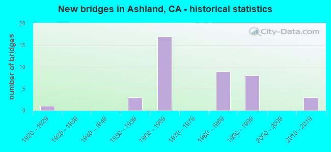
- New bridges - historical statistics
- 11920-1929
- 31950-1959
- 171960-1969
- 91980-1989
- 81990-1999
- 32010-2019
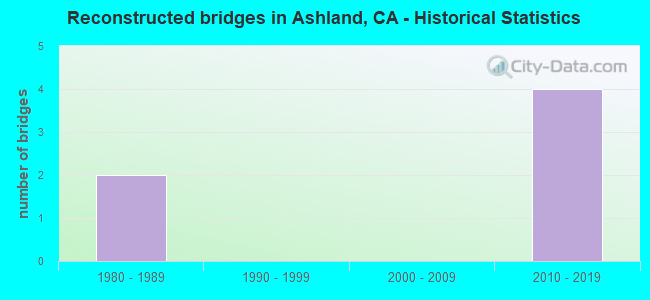
- Reconstructed bridges - Historical Statistics
- 21980-1989
- 01990-1999
- 02000-2009
- 42010-2019
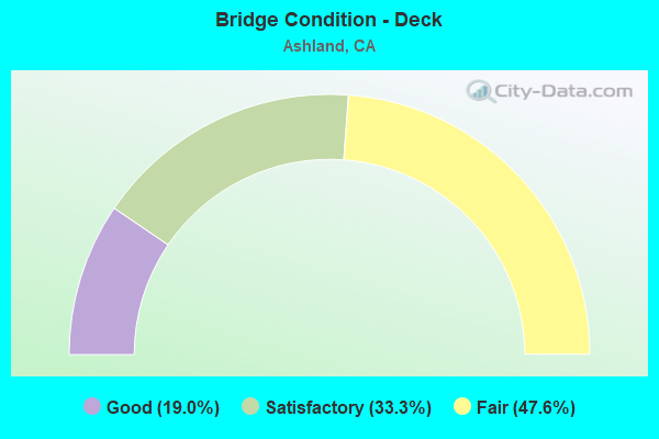
- Bridge Condition - Deck
- 19.0%Good
- 33.3%Satisfactory
- 47.6%Fair
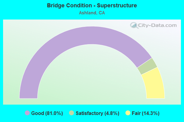
- Bridge Condition - Superstructure
- 81.0%Good
- 4.8%Satisfactory
- 14.3%Fair
Find on map >> Show street view
Structure Number: 33 0175, Location: 04-ALA-880-20.11 (Lat: 37.684661, Lng: -122.128808), Route carried "on" structure: Interstate 880, Year Built: 1953, Year Reconstructed: 1991, Status: Open, Structure Length: 3.05m (10.01ft), Average Daily Traffic: 222,000 (year 2016), Truck Traffic: 11%, Average Future Daily Traffic: 345,864 (year 2038), Design Load: HS 20, Features Intersected: SAN LORENZO CREEK
Minimum Vertical Clearance: 30+ m (98+ ft), Kilometerpoint: 20.110, Lanes on structure: 12, Base Highway Network: Yes (Inventory Route: 8, Subroute: 1), Owner: State Highway Agency, Approaching Roadway Width: 53.6m (175.9ft), Skew: 39 degrees, Material/Design: Steel, Design/Construction: Stringer/Multi-beam, Number Of Spans In Main Unit: 1, Length of Maximum Span: 30.5m (100.1ft), Curb-To-Curb Width: 52.0m (170.6ft), Out-to-Out Width: 53.6m (175.9ft)
Condition: Deck: Good, Superstructure: Good, Substructure: Good, Channel: Very good, Operating Rating: 41.1 metric tons, Method Used To Determine Operating Rating: Load and Resistance Factor Rating (LRFR) rating reported by rating factor(RF) method using HL-93 loadings, Inventory Rating: 23.3 metric tons, Method Used To Determine Inventory Rating: Load and Resistance Factor Rating (LRFR) rating reported by rating factor(RF) method using HL-93 loadings, Structural Evaluation: Somewhat better than minimum adequacy, Deck Geometry: Superior to present desirable criteria, Waterway Adequacy: Equal to present desirable criteria, Approach Roadway Alignment: Equal to present desirable criteria, Designated Inspection Frequency: Every 24 months, Other Special Inspection Frequency: Every 48 months, Inspection Date: May 2020, Other Special Inspection Date: August 2019, Deck Structure Type: Concrete Cast-file-Place
Find on map >> Show street view
Structure Number: 33 0175S, Location: 04-ALA-880-20.11 (Lat: 37.684747, Lng: -122.128697), Route carried "on" structure: Ramp Interstate 880, Year Built: 1992, Status: Open, Structure Length: 2.50m (8.20ft), Average Daily Traffic: 1,100 (year 2016), Truck Traffic: 5%, Average Future Daily Traffic: 1,287 (year 2038), Design Load: HS 20+Mod, Features Intersected: SAN LORENZO CREEK
Minimum Vertical Clearance: 30+ m (98+ ft), Kilometerpoint: 20.110, Lanes on structure: 1, Owner: State Highway Agency, Approaching Roadway Width: 7.3m (24.0ft), Material/Design: Steel, Design/Construction: Stringer/Multi-beam, Number Of Spans In Main Unit: 1, Length of Maximum Span: 25.0m (82.0ft), Curb-To-Curb Width: 7.3m (24.0ft), Out-to-Out Width: 8.3m (27.2ft)
Condition: Deck: Fair, Superstructure: Good, Substructure: Good, Channel: Very good, Operating Rating: 89.4 metric tons, Method Used To Determine Operating Rating: Load Factor (LF), Inventory Rating: 53.8 metric tons, Method Used To Determine Inventory Rating: Load Factor (LF), Structural Evaluation: Better than present minimum criteria, Deck Geometry: Better than present minimum criteria, Waterway Adequacy: Equal to present desirable criteria, Approach Roadway Alignment: Equal to present desirable criteria, Designated Inspection Frequency: Every 24 months, Inspection Date: May 2020, Deck Structure Type: Concrete Cast-file-Place
Find on map >> Show street view
Structure Number: 33 0202F, Location: 04-ALA-238-R14.47 (Lat: 37.690125, Lng: -122.095108), Route carried "on" structure: Ramp State highway 238, Year Built: 1988, Year Reconstructed: 2010, Status: Open, Structure Length: 7.10m (23.29ft), Average Daily Traffic: 25,000 (year 1998), Truck Traffic: 11%, Average Future Daily Traffic: 28,858 (year 2040), Design Load: HS 20+Mod, Features Intersected: CASTRO VALLEY BLVD
Minimum Vertical Clearance: 30+ m (98+ ft), Kilometerpoint: 14.470, Lanes on structure: 4, Lanes under structure: 4, Owner: State Highway Agency, Approaching Roadway Width: 17.7m (58.1ft), Skew: 4 degrees, Material/Design: Prestressed concrete continuous, Design/Construction: Box Beam or Girders - Multiple, Number Of Spans In Main Unit: 2, Length of Maximum Span: 38.4m (126.0ft), Curb or Sidewalk Widths: Left: 0.5m (1.6ft), Right: 0.5m (1.6ft), Curb-To-Curb Width: 16.8m (55.1ft), Out-to-Out Width: 17.7m (58.1ft)
Condition: Deck: Satisfactory, Superstructure: Good, Substructure: Good, Operating Rating: 54.1 metric tons, Method Used To Determine Operating Rating: Assigned rating based on Load Factor Design (LFD) reported in metric tons, Inventory Rating: 32.4 metric tons, Method Used To Determine Inventory Rating: Assigned rating based on Load Factor Design (LFD) reported in metric tons, Structural Evaluation: Better than present minimum criteria, Deck Geometry: Somewhat better than minimum adequacy, Underclear: Meets minimum limits, Approach Roadway Alignment: Equal to present desirable criteria, Designated Inspection Frequency: Every 24 months, Inspection Date: Febuary 2022, Deck Structure Type: Concrete Cast-file-Place
Find on map >> Show street view
Structure Number: 33 0212L, Location: 04-ALA-238-14.93 (Lat: 37.689139, Lng: -122.105139), Route carried "on" structure: State highway 238, Year Built: 1994, Year Reconstructed: 2010, Status: Open, Structure Length: 7.40m (24.28ft), Average Daily Traffic: 121,000 (year 2010), Truck Traffic: 10%, Average Future Daily Traffic: 227,429 (year 2042), Design Load: HS 20+Mod, Features Intersected: SR 185 (14TH STREET)
Minimum Vertical Clearance: 30+ m (98+ ft), Kilometerpoint: 14.930, Lanes on structure: 3, Lanes under structure: 4, Base Highway Network: Yes (Inventory Route: 2, Subroute: 1), Owner: State Highway Agency, Approaching Roadway Width: 25.5m (83.7ft), Skew: 4 degrees, Material/Design: Prestressed concrete continuous, Design/Construction: Box Beam or Girders - Multiple, Number Of Spans In Main Unit: 2, Length of Maximum Span: 38.0m (124.7ft), Curb-To-Curb Width: 25.5m (83.7ft), Out-to-Out Width: 26.5m (86.9ft)
Condition: Deck: Satisfactory, Superstructure: Good, Substructure: Good, Operating Rating: 54.1 metric tons, Method Used To Determine Operating Rating: Assigned rating based on Load Factor Design (LFD) reported in metric tons, Inventory Rating: 32.4 metric tons, Method Used To Determine Inventory Rating: Assigned rating based on Load Factor Design (LFD) reported in metric tons, Structural Evaluation: Better than present minimum criteria, Deck Geometry: Superior to present desirable criteria, Underclear: Better than present minimum criteria, Approach Roadway Alignment: Equal to present desirable criteria, Designated Inspection Frequency: Every 24 months, Inspection Date: Febuary 2022, Deck Structure Type: Concrete Cast-file-Place
Find on map >> Show street view
Structure Number: 33 0217L, Location: 04-ALA-238-15.41 (Lat: 37.688672, Lng: -122.114250), Route carried "on" structure: State highway 238, Year Built: 1994, Year Reconstructed: 2010, Status: Open, Structure Length: 13.00m (42.65ft), Average Daily Traffic: 121,000 (year 2010), Truck Traffic: 10%, Average Future Daily Traffic: 221,372 (year 2042), Design Load: HS 20+Mod, Features Intersected: UP RR & BARTD
Minimum Vertical Clearance: 30+ m (98+ ft), Kilometerpoint: 15.410, Lanes on structure: 3, Base Highway Network: Yes (Inventory Route: 2, Subroute: 1), Owner: State Highway Agency, Approaching Roadway Width: 18.6m (61.0ft), Skew: 6 degrees, Material/Design: Concrete continuous, Design/Construction: Stringer/Multi-beam, Number Of Spans In Main Unit: 4, Length of Maximum Span: 45.0m (147.6ft), Curb-To-Curb Width: 19.0m (62.3ft), Out-to-Out Width: 20.0m (65.6ft)
Condition: Deck: Satisfactory, Superstructure: Good, Substructure: Good, Operating Rating: 54.1 metric tons, Method Used To Determine Operating Rating: Assigned rating based on Load Factor Design (LFD) reported in metric tons, Inventory Rating: 32.4 metric tons, Method Used To Determine Inventory Rating: Assigned rating based on Load Factor Design (LFD) reported in metric tons, Structural Evaluation: Better than present minimum criteria, Deck Geometry: Superior to present desirable criteria, Underclear: High priority of corrective action, Approach Roadway Alignment: Equal to present desirable criteria, Designated Inspection Frequency: Every 24 months, Inspection Date: Febuary 2022, Deck Structure Type: Concrete Cast-file-Place
Find on map >> Show street view
Structure Number: 33 0217R, Location: 04-ALA-238-15.41 (Lat: 37.689119, Lng: -122.115089), Route carried "on" structure: State highway 238, Year Built: 1994, Year Reconstructed: 2010, Status: Open, Structure Length: 11.00m (36.09ft), Average Daily Traffic: 100,000 (year 2010), Truck Traffic: 10%, Average Future Daily Traffic: 187,958 (year 2042), Design Load: HS 20+Mod, Features Intersected: UP RR & BARTD
Minimum Vertical Clearance: 30+ m (98+ ft), Kilometerpoint: 15.410, Lanes on structure: 3, Base Highway Network: Yes (Inventory Route: 2, Subroute: 1), Owner: State Highway Agency, Approaching Roadway Width: 21.0m (68.9ft), Skew: 6 degrees, Material/Design: Steel, Design/Construction: Stringer/Multi-beam, Number Of Spans In Main Unit: 3, Length of Maximum Span: 47.2m (154.9ft), Curb-To-Curb Width: 20.8m (68.2ft), Out-to-Out Width: 21.8m (71.5ft)
Condition: Deck: Satisfactory, Superstructure: Good, Substructure: Good, Operating Rating: 54.1 metric tons, Method Used To Determine Operating Rating: Assigned rating based on Load Factor Design (LFD) reported in metric tons, Inventory Rating: 32.4 metric tons, Method Used To Determine Inventory Rating: Assigned rating based on Load Factor Design (LFD) reported in metric tons, Structural Evaluation: Better than present minimum criteria, Deck Geometry: Superior to present desirable criteria, Underclear: Meets minimum limits, Approach Roadway Alignment: Equal to present desirable criteria, Designated Inspection Frequency: Every 24 months, Inspection Date: Febuary 2022, Deck Structure Type: Concrete Cast-file-Place
Find on map >> Show street view
Structure Number: 33 0337, Location: 04-ALA-580-R32.72 (Lat: 37.708042, Lng: -122.122642), Route carried "on" structure: County highway , Year Built: 1965, Status: Open, Structure Length: 8.14m (26.71ft), Average Daily Traffic: 5,500 (year 2009), Truck Traffic: 3%, Average Future Daily Traffic: 6,477 (year 2038), Design Load: HS 20, Features Intersected: INTERSTATE 580, Facility Carried by Structure: FAIRMONT DRIVE
Minimum Vertical Clearance: 30+ m (98+ ft), Kilometerpoint: 0.000, Lanes on structure: 4, Lanes under structure: 8, Base Highway Network: Yes, Owner: State Highway Agency, Approaching Roadway Width: 19.5m (64.0ft), Skew: 29 degrees, Material/Design: Concrete continuous, Design/Construction: Box Beam or Girders - Multiple, Number Of Spans In Main Unit: 4, Length of Maximum Span: 26.8m (87.9ft), Curb or Sidewalk Widths: Left: 1.8m (5.9ft), Right: 1.8m (5.9ft), Curb-To-Curb Width: 19.5m (64.0ft), Out-to-Out Width: 25.6m (84.0ft)
Condition: Deck: Fair, Superstructure: Good, Substructure: Good, Operating Rating: 45.0 metric tons, Method Used To Determine Operating Rating: Load and Resistance Factor Rating (LRFR) rating reported by rating factor(RF) method using HL-93 loadings, Inventory Rating: 34.7 metric tons, Method Used To Determine Inventory Rating: Load and Resistance Factor Rating (LRFR) rating reported by rating factor(RF) method using HL-93 loadings, Structural Evaluation: Better than present minimum criteria, Deck Geometry: Better than present minimum criteria, Underclear: High priority of corrective action, Approach Roadway Alignment: Equal to present minimum criteria, Designated Inspection Frequency: Every 24 months, Inspection Date: April 2020, Deck Structure Type: Concrete Cast-file-Place
Find on map >> Show street view
Structure Number: 33 0338, Location: 04-ALA-580-R32.32 (Lat: 37.704919, Lng: -122.116828), Route carried "on" structure: County highway , Year Built: 1965, Status: Open, Structure Length: 10.55m (34.61ft), Average Daily Traffic: 4,375 (year 2009), Truck Traffic: 5%, Average Future Daily Traffic: 5,398 (year 2038), Design Load: HS 20, Features Intersected: INTERSTATE 580, Facility Carried by Structure: 159TH AVE
Minimum Vertical Clearance: 30+ m (98+ ft), Kilometerpoint: 0.000, Lanes on structure: 2, Lanes under structure: 12, Owner: State Highway Agency, Approaching Roadway Width: 8.5m (27.9ft), Skew: 9 degrees, Material/Design: Concrete continuous, Design/Construction: Box Beam or Girders - Multiple, Number Of Spans In Main Unit: 5, Length of Maximum Span: 28.7m (94.2ft), Curb or Sidewalk Widths: Left: 1.8m (5.9ft), Right: 1.8m (5.9ft), Curb-To-Curb Width: 8.5m (27.9ft), Out-to-Out Width: 12.8m (42.0ft)
Condition: Deck: Fair, Superstructure: Good, Substructure: Good, Operating Rating: 70.0 metric tons, Method Used To Determine Operating Rating: Load Factor (LF), Inventory Rating: 41.8 metric tons, Method Used To Determine Inventory Rating: Load Factor (LF), Structural Evaluation: Better than present minimum criteria, Deck Geometry: Meets minimum limits, Underclear: High priority of corrective action, Approach Roadway Alignment: High priority of corrective action, Designated Inspection Frequency: Every 24 months, Inspection Date: April 2020, Deck Structure Type: Concrete Cast-file-Place
Find on map >> Show street view
Structure Number: 33 0395K, Location: 04-ALA-580-R31.71 (Lat: 37.699250, Lng: -122.108161), Route carried "on" structure: Bypass Interstate 580, Year Built: 1965, Status: Open, Structure Length: 5.88m (19.29ft), Average Daily Traffic: 4,800 (year 2011), Truck Traffic: 7%, Average Future Daily Traffic: 8,043 (year 2037), Design Load: HS 20, Features Intersected: 164TH AVENUE
Minimum Vertical Clearance: 30+ m (98+ ft), Kilometerpoint: 31.710, Lanes on structure: 1, Lanes under structure: 4, Base Highway Network: Yes (Inventory Route: 5, Subroute: 1), Owner: State Highway Agency, Approaching Roadway Width: 6.7m (22.0ft), Skew: 3 degrees, Material/Design: Concrete continuous, Design/Construction: Box Beam or Girders - Multiple, Number Of Spans In Main Unit: 3, Length of Maximum Span: 27.4m (89.9ft), Curb or Sidewalk Widths: Left: 0.0m, Right: 0.6m (2.0ft), Curb-To-Curb Width: 6.7m (22.0ft), Out-to-Out Width: 7.9m (25.9ft)
Condition: Deck: Fair, Superstructure: Fair, Substructure: Good, Operating Rating: 51.8 metric tons, Method Used To Determine Operating Rating: Load and Resistance Factor Rating (LRFR) rating reported by rating factor(RF) method using HL-93 loadings, Inventory Rating: 37.3 metric tons, Method Used To Determine Inventory Rating: Load and Resistance Factor Rating (LRFR) rating reported by rating factor(RF) method using HL-93 loadings, Structural Evaluation: Somewhat better than minimum adequacy, Deck Geometry: High priority of replacement, Underclear: Meets minimum limits, Approach Roadway Alignment: Meets minimum limits, Designated Inspection Frequency: Every 24 months, Inspection Date: April 2020, Deck Structure Type: Concrete Cast-file-Place
Find on map >> Show street view
Structure Number: 33 0395L, Location: 04-ALA-580-R31.71 (Lat: 37.699647, Lng: -122.108142), Route carried "on" structure: Interstate 580, Year Built: 1965, Status: Open, Structure Length: 5.90m (19.36ft), Average Daily Traffic: 79,000 (year 2017), Average Future Daily Traffic: 102,357 (year 2037), Design Load: HS 20, Features Intersected: 164TH AVENUE
Minimum Vertical Clearance: 30+ m (98+ ft), Kilometerpoint: 31.710, Lanes on structure: 4, Lanes under structure: 4, Base Highway Network: Yes (Inventory Route: 5, Subroute: 1), Owner: State Highway Agency, Approaching Roadway Width: 20.1m (65.9ft), Skew: 4 degrees, Material/Design: Concrete continuous, Design/Construction: Box Beam or Girders - Multiple, Number Of Spans In Main Unit: 3, Length of Maximum Span: 29.6m (97.1ft), Curb-To-Curb Width: 20.1m (65.9ft), Out-to-Out Width: 20.7m (67.9ft)
Condition: Deck: Fair, Superstructure: Fair, Substructure: Good, Operating Rating: 52.8 metric tons, Method Used To Determine Operating Rating: Load and Resistance Factor Rating (LRFR) rating reported by rating factor(RF) method using HL-93 loadings, Inventory Rating: 38.2 metric tons, Method Used To Determine Inventory Rating: Load and Resistance Factor Rating (LRFR) rating reported by rating factor(RF) method using HL-93 loadings, Structural Evaluation: Somewhat better than minimum adequacy, Deck Geometry: Equal to present minimum criteria, Underclear: Meets minimum limits, Approach Roadway Alignment: Equal to present desirable criteria, Length Of Structure Improvement: 5.91m (19.39ft), Designated Inspection Frequency: Every 24 months, Inspection Date: April 2020, Deck Structure Type: Concrete Cast-file-Place
Find on map >> Show street view
Structure Number: 33 0396L, Location: 04-ALA-580-R31.34 (Lat: 37.695322, Lng: -122.104217), Route carried "on" structure: Interstate 580, Year Built: 1965, Status: Open, Structure Length: 4.97m (16.31ft), Average Daily Traffic: 79,000 (year 2017), Average Future Daily Traffic: 102,357 (year 2037), Design Load: HS 20, Features Intersected: 167TH AVENUE
Minimum Vertical Clearance: 30+ m (98+ ft), Kilometerpoint: 31.340, Lanes on structure: 5, Lanes under structure: 4, Base Highway Network: Yes (Inventory Route: 5, Subroute: 1), Owner: State Highway Agency, Approaching Roadway Width: 20.1m (65.9ft), Skew: 9 degrees, Material/Design: Concrete continuous, Design/Construction: Box Beam or Girders - Multiple, Number Of Spans In Main Unit: 3, Length of Maximum Span: 24.3m (79.7ft), Curb-To-Curb Width: 20.1m (65.9ft), Out-to-Out Width: 26.7m (87.6ft)
Condition: Deck: Fair, Superstructure: Fair, Substructure: Good, Operating Rating: 41.1 metric tons, Method Used To Determine Operating Rating: Load and Resistance Factor Rating (LRFR) rating reported by rating factor(RF) method using HL-93 loadings, Inventory Rating: 31.8 metric tons, Method Used To Determine Inventory Rating: Load and Resistance Factor Rating (LRFR) rating reported by rating factor(RF) method using HL-93 loadings, Structural Evaluation: Somewhat better than minimum adequacy, Deck Geometry: High priority of replacement, Underclear: Meets minimum limits, Approach Roadway Alignment: Equal to present desirable criteria, Length Of Structure Improvement: 4.97m (16.31ft), Designated Inspection Frequency: Every 24 months, Inspection Date: April 2020, Deck Structure Type: Concrete Cast-file-Place
Find on map >> Show street view
Structure Number: 33 0396R, Location: 04-ALA-580-R31.34 (Lat: 37.695308, Lng: -122.103833), Route carried "on" structure: Interstate 580, Year Built: 1965, Status: Open, Structure Length: 5.68m (18.64ft), Average Daily Traffic: 79,000 (year 2017), Average Future Daily Traffic: 102,357 (year 2037), Design Load: HS 20, Features Intersected: 167TH AVENUE
Minimum Vertical Clearance: 30+ m (98+ ft), Kilometerpoint: 31.340, Lanes on structure: 4, Lanes under structure: 4, Base Highway Network: Yes (Inventory Route: 5, Subroute: 1), Owner: State Highway Agency, Approaching Roadway Width: 20.1m (65.9ft), Skew: 9 degrees, Material/Design: Concrete continuous, Design/Construction: Box Beam or Girders - Multiple, Number Of Spans In Main Unit: 3, Length of Maximum Span: 24.2m (79.4ft), Curb-To-Curb Width: 20.1m (65.9ft), Out-to-Out Width: 20.7m (67.9ft)
Condition: Deck: Fair, Superstructure: Good, Substructure: Good, Operating Rating: 43.4 metric tons, Method Used To Determine Operating Rating: Load and Resistance Factor Rating (LRFR) rating reported by rating factor(RF) method using HL-93 loadings, Inventory Rating: 33.4 metric tons, Method Used To Determine Inventory Rating: Load and Resistance Factor Rating (LRFR) rating reported by rating factor(RF) method using HL-93 loadings, Structural Evaluation: Better than present minimum criteria, Deck Geometry: Equal to present minimum criteria, Underclear: Meets minimum limits, Approach Roadway Alignment: Equal to present desirable criteria, Length Of Structure Improvement: 5.67m (18.60ft), Designated Inspection Frequency: Every 24 months, Inspection Date: April 2020, Deck Structure Type: Concrete Cast-file-Place
Find on map >> Show street view
Structure Number: 33 0436F, Location: 04-ALA-580-M31.10 (Lat: 37.689119, Lng: -122.098933), Route carried "on" structure: Ramp Interstate 580, Year Built: 1988, Status: Open, Structure Length: 24.99m (81.99ft), Average Daily Traffic: 46,000 (year 2017), Truck Traffic: 9%, Average Future Daily Traffic: 64,343 (year 2037), Design Load: HS 20+Mod, Features Intersected: SR 238 & CONNECTORS
Minimum Vertical Clearance: 30+ m (98+ ft), Kilometerpoint: 31.100, Lanes on structure: 2, Lanes under structure: 8, Base Highway Network: Yes (Inventory Route: 5, Subroute: 1), Owner: State Highway Agency, Approaching Roadway Width: 9.8m (32.2ft), Material/Design: Prestressed concrete continuous, Design/Construction: Box Beam or Girders - Multiple, Number Of Spans In Main Unit: 8, Length of Maximum Span: 42.7m (140.1ft), Curb-To-Curb Width: 9.8m (32.2ft), Out-to-Out Width: 10.8m (35.4ft)
Condition: Deck: Fair, Superstructure: Good, Substructure: Good, Operating Rating: 54.1 metric tons, Method Used To Determine Operating Rating: Assigned rating based on Load Factor Design (LFD) reported in metric tons, Inventory Rating: 32.4 metric tons, Method Used To Determine Inventory Rating: Assigned rating based on Load Factor Design (LFD) reported in metric tons, Structural Evaluation: Better than present minimum criteria, Deck Geometry: Equal to present minimum criteria, Underclear: Superior to present desirable criteria, Approach Roadway Alignment: Equal to present desirable criteria, Designated Inspection Frequency: Every 24 months, Inspection Date: April 2020, Deck Structure Type: Concrete Cast-file-Place
Find on map >> Show street view
Structure Number: 33 0524F, Location: 04-ALA-238-R14.58 (Lat: 37.689931, Lng: -122.096844), Route carried "on" structure: Ramp State highway 238, Year Built: 1988, Status: Open, Structure Length: 12.89m (42.29ft), Average Daily Traffic: 10,500 (year 1994), Truck Traffic: 11%, Average Future Daily Traffic: 16,410 (year 2042), Design Load: HS 20+Mod, Features Intersected: SR 238 NB,CASTRO ON RAMP
Minimum Vertical Clearance: 7.62m (25.00ft), Kilometerpoint: 14.580, Lanes on structure: 3, Lanes under structure: 2, Owner: State Highway Agency, Approaching Roadway Width: 11.9m (39.0ft), Material/Design: Prestressed concrete continuous, Design/Construction: Box Beam or Girders - Multiple, Number Of Spans In Main Unit: 4, Length of Maximum Span: 42.7m (140.1ft), Curb-To-Curb Width: 11.7m (38.4ft), Out-to-Out Width: 12.8m (42.0ft)
Condition: Deck: Satisfactory, Superstructure: Good, Substructure: Good, Operating Rating: 54.1 metric tons, Method Used To Determine Operating Rating: Assigned rating based on Load Factor Design (LFD) reported in metric tons, Inventory Rating: 32.4 metric tons, Method Used To Determine Inventory Rating: Assigned rating based on Load Factor Design (LFD) reported in metric tons, Structural Evaluation: Better than present minimum criteria, Deck Geometry: High priority of corrective action, Underclear: Somewhat better than minimum adequacy, Approach Roadway Alignment: Equal to present desirable criteria, Designated Inspection Frequency: Every 24 months, Inspection Date: Febuary 2022, Deck Structure Type: Concrete Cast-file-Place
Find on map >> Show street view
Structure Number: 33 0525G, Location: 04-ALA-580-R30.80 (Lat: 37.690492, Lng: -122.096181), Route carried "on" structure: Ramp Interstate 580, Year Built: 1991, Status: Open, Structure Length: 13.11m (43.01ft), Average Daily Traffic: 79,000 (year 2017), Truck Traffic: 12%, Average Future Daily Traffic: 85,791 (year 2037), Design Load: HS 20+Mod, Features Intersected: INTERSTATE 238 NB
Minimum Vertical Clearance: 30+ m (98+ ft), Kilometerpoint: 30.800, Lanes on structure: 3, Lanes under structure: 2, Base Highway Network: Yes (Inventory Route: 5, Subroute: 1), Owner: State Highway Agency, Approaching Roadway Width: 11.7m (38.4ft), Material/Design: Prestressed concrete continuous, Design/Construction: Box Beam or Girders - Multiple, Number Of Spans In Main Unit: 4, Length of Maximum Span: 37.5m (123.0ft), Curb-To-Curb Width: 11.7m (38.4ft), Out-to-Out Width: 12.8m (42.0ft)
Condition: Deck: Fair, Superstructure: Good, Substructure: Good, Operating Rating: 54.1 metric tons, Method Used To Determine Operating Rating: Assigned rating based on Load Factor Design (LFD) reported in metric tons, Inventory Rating: 32.4 metric tons, Method Used To Determine Inventory Rating: Assigned rating based on Load Factor Design (LFD) reported in metric tons, Structural Evaluation: Better than present minimum criteria, Deck Geometry: High priority of corrective action, Underclear: Equal to present minimum criteria, Approach Roadway Alignment: Equal to present desirable criteria, Designated Inspection Frequency: Every 24 months, Inspection Date: April 2020, Deck Structure Type: Concrete Cast-file-Place
Find on map >> Show street view
Structure Number: 33 0526G, Location: 04-ALA-238-R14.49 (Lat: 37.689697, Lng: -122.097228), Route carried "on" structure: Ramp State highway 238, Year Built: 1988, Status: Open, Structure Length: 20.45m (67.09ft), Average Daily Traffic: 28,500 (year 2010), Truck Traffic: 11%, Average Future Daily Traffic: 38,688 (year 2042), Design Load: HS 20+Mod, Features Intersected: S238-E580,W580-N238,N238
Minimum Vertical Clearance: 5.30m (17.39ft), Kilometerpoint: 14.490, Lanes on structure: 2, Lanes under structure: 6, Owner: State Highway Agency, Approaching Roadway Width: 15.5m (50.9ft), Skew: 4 degrees, Material/Design: Prestressed concrete continuous, Design/Construction: Box Beam or Girders - Multiple, Number Of Spans In Main Unit: 6, Length of Maximum Span: 47.2m (154.9ft), Curb-To-Curb Width: 15.4m (50.5ft), Out-to-Out Width: 16.5m (54.1ft)
Condition: Deck: Satisfactory, Superstructure: Satisfactory, Substructure: Good, Operating Rating: 54.1 metric tons, Method Used To Determine Operating Rating: Assigned rating based on Load Factor Design (LFD) reported in metric tons, Inventory Rating: 32.4 metric tons, Method Used To Determine Inventory Rating: Assigned rating based on Load Factor Design (LFD) reported in metric tons, Structural Evaluation: Equal to present minimum criteria, Deck Geometry: Superior to present desirable criteria, Underclear: Meets minimum limits, Approach Roadway Alignment: Equal to present desirable criteria, Designated Inspection Frequency: Every 24 months, Inspection Date: Febuary 2022, Deck Structure Type: Concrete Cast-file-Place
Find on map >> Show street view
Structure Number: 33 0726R, Location: 04-ALA-238-14.93 (Lat: 37.689444, Lng: -122.105528), Route carried "on" structure: Interstate 238, Year Built: 2010, Status: Open, Structure Length: 7.40m (24.28ft), Average Daily Traffic: 121,000 (year 2010), Truck Traffic: 10%, Average Future Daily Traffic: 227,429 (year 2042), Design Load: HS 20, Features Intersected: SR 185 (14TH STREET)
Minimum Vertical Clearance: 30+ m (98+ ft), Kilometerpoint: 14.930, Lanes on structure: 4, Lanes under structure: 4, Base Highway Network: Yes (Inventory Route: 2, Subroute: 1), Owner: State Highway Agency, Approaching Roadway Width: 21.4m (70.2ft), Skew: 4 degrees, Material/Design: Concrete continuous, Design/Construction: Box Beam or Girders - Multiple, Number Of Spans In Main Unit: 2, Length of Maximum Span: 38.2m (125.3ft), Curb-To-Curb Width: 20.3m (66.6ft), Out-to-Out Width: 21.3m (69.9ft)
Condition: Deck: Satisfactory, Superstructure: Good, Substructure: Good, Operating Rating: 54.1 metric tons, Method Used To Determine Operating Rating: Assigned rating based on Load Factor Design (LFD) reported in metric tons, Inventory Rating: 32.4 metric tons, Method Used To Determine Inventory Rating: Assigned rating based on Load Factor Design (LFD) reported in metric tons, Structural Evaluation: Better than present minimum criteria, Deck Geometry: Equal to present minimum criteria, Underclear: Somewhat better than minimum adequacy, Approach Roadway Alignment: Equal to present desirable criteria, Designated Inspection Frequency: Every 24 months, Inspection Date: Febuary 2022, Deck Structure Type: Concrete Cast-file-Place
Find on map >> Show street view
Structure Number: 33 0739, Location: 04-ALA-238-16.14 (Lat: 37.690967, Lng: -122.127739), Route carried "on" structure: Interstate 238, Year Built: 2010, Status: Open, Structure Length: 2.60m (8.53ft), Average Daily Traffic: 121,000 (year 2010), Truck Traffic: 10%, Average Future Daily Traffic: 221,372 (year 2042), Design Load: HS 20, Features Intersected: UP RR, BNSF, & AMTRAK
Minimum Vertical Clearance: 30+ m (98+ ft), Kilometerpoint: 16.140, Lanes on structure: 6, Base Highway Network: Yes (Inventory Route: 2, Subroute: 1), Owner: State Highway Agency, Approaching Roadway Width: 36.5m (119.8ft), Skew: 24 degrees, Material/Design: Prestressed concrete, Design/Construction: Girder and Floorbeam System, Number Of Spans In Main Unit: 1, Length of Maximum Span: 25.3m (83.0ft), Curb-To-Curb Width: 36.0m (118.1ft), Out-to-Out Width: 37.6m (123.4ft)
Condition: Deck: Good, Superstructure: Good, Substructure: Good, Operating Rating: 54.1 metric tons, Method Used To Determine Operating Rating: Assigned rating based on Load Factor Design (LFD) reported in metric tons, Inventory Rating: 32.4 metric tons, Method Used To Determine Inventory Rating: Assigned rating based on Load Factor Design (LFD) reported in metric tons, Structural Evaluation: Better than present minimum criteria, Deck Geometry: Superior to present desirable criteria, Underclear: Superior to present desirable criteria, Approach Roadway Alignment: Equal to present desirable criteria, Designated Inspection Frequency: Every 24 months, Inspection Date: Febuary 2022, Deck Structure Type: Concrete Cast-file-Place
Find on map >> Show street view
Structure Number: 33C0206, Location: 0.05 MI S OF LEWELLING BL (Lat: 37.685444, Lng: -122.116792), Route carried "on" structure: County highway , Year Built: 1927, Status: Open, Structure Length: 4.45m (14.60ft), Average Daily Traffic: 11,800 (year 2014), Truck Traffic: 2%, Average Future Daily Traffic: 16,139 (year 2042), Features Intersected: SAN LORENZO CREEK, Facility Carried by Structure: MEEKLAND AVE
Minimum Vertical Clearance: 30+ m (98+ ft), Kilometerpoint: 0.000, Lanes on structure: 2, Owner: County Highway Agency, Approaching Roadway Width: 12.5m (41.0ft), Skew: 4 degrees, Material/Design: Steel, Design/Construction: Stringer/Multi-beam, Number Of Spans In Main Unit: 1, Number Of Approach Spans: 2, Length of Maximum Span: 25.6m (84.0ft), Curb or Sidewalk Widths: Left: 2.0m (6.6ft), Right: 2.0m (6.6ft), Curb-To-Curb Width: 7.3m (24.0ft), Out-to-Out Width: 12.1m (39.7ft)
Condition: Deck: Fair, Superstructure: Good, Substructure: Good, Channel: Very good, Operating Rating: 37.9 metric tons, Method Used To Determine Operating Rating: Load and Resistance Factor Rating (LRFR) rating reported by rating factor(RF) method using HL-93 loadings, Inventory Rating: 29.5 metric tons, Method Used To Determine Inventory Rating: Load and Resistance Factor Rating (LRFR) rating reported by rating factor(RF) method using HL-93 loadings, Structural Evaluation: Better than present minimum criteria, Deck Geometry: High priority of replacement, Waterway Adequacy: Equal to present desirable criteria, Approach Roadway Alignment: Equal to present minimum criteria, Designated Inspection Frequency: Every 24 months, Critical Feature Inspection Frequency: Every 24 months, Inspection Date: June 2020, Critical Feature Inspection Date: September 2020, Deck Structure Type: Concrete Cast-file-Place, Wearing Surface/Protective System: Wearing Surface: Bituminous
Find on map >> Show street view
Structure Number: 33C0237, Location: ELGIN ST & ASHLAND AVE (Lat: 37.692006, Lng: -122.119219), Route carried "on" structure: County highway , Year Built: 1960, Year Reconstructed: 1994, Status: Open, Structure Length: 3.05m (10.01ft), Average Daily Traffic: 2,000 (year 2014), Truck Traffic: 1%, Average Future Daily Traffic: 5,543 (year 2042), Features Intersected: ASHLAND AVE, Facility Carried by Structure: ELGIN ST
Minimum Vertical Clearance: 30+ m (98+ ft), Kilometerpoint: 0.000, Lanes on structure: 2, Lanes under structure: 2, Owner: County Highway Agency, Approaching Roadway Width: 10.2m (33.5ft), Skew: 4 degrees, Material/Design: Prestressed concrete, Design/Construction: Stringer/Multi-beam, Number Of Spans In Main Unit: 2, Length of Maximum Span: 14.7m (48.2ft), Curb or Sidewalk Widths: Left: 1.7m (5.6ft), Right: 0.5m (1.6ft), Curb-To-Curb Width: 10.2m (33.5ft), Out-to-Out Width: 14.4m (47.2ft)
Condition: Deck: Good, Superstructure: Good, Substructure: Good, Operating Rating: 29.2 metric tons, Method Used To Determine Operating Rating: Field evaluation and documented engineering judgment, Inventory Rating: 17.5 metric tons, Method Used To Determine Inventory Rating: Field evaluation and documented engineering judgment, Structural Evaluation: Meets minimum limits, Deck Geometry: Somewhat better than minimum adequacy, Underclear: High priority of corrective action, Approach Roadway Alignment: Equal to present minimum criteria, Designated Inspection Frequency: Every 24 months, Inspection Date: June 2020, Deck Structure Type: Concrete Cast-file-Place, Wearing Surface/Protective System: Wearing Surface: Bituminous
Find on map >> Show street view
Structure Number: 33C0375, Location: JUST S LEWELLING BLVD (Lat: 37.685731, Lng: -122.124917), Route carried "on" structure: County highway , Year Built: 1950, Status: Open, Structure Length: 2.01m (6.59ft), Average Daily Traffic: 3,400 (year 2014), Truck Traffic: 2%, Average Future Daily Traffic: 3,765 (year 2042), Design Load: H 15, Features Intersected: SAN LORENZO CREEK, Facility Carried by Structure: VIA GRANADA
Minimum Vertical Clearance: 30+ m (98+ ft), Kilometerpoint: 0.000, Lanes on structure: 2, Owner: County Highway Agency, Approaching Roadway Width: 13.4m (44.0ft), Skew: 1 degrees, Material/Design: Steel, Design/Construction: Stringer/Multi-beam, Number Of Spans In Main Unit: 1, Length of Maximum Span: 18.9m (62.0ft), Curb or Sidewalk Widths: Left: 1.5m (4.9ft), Right: 1.5m (4.9ft), Curb-To-Curb Width: 7.9m (25.9ft), Out-to-Out Width: 11.5m (37.7ft)
Condition: Deck: Good, Superstructure: Good, Substructure: Good, Channel: Very good, Operating Rating: 66.4 metric tons, Method Used To Determine Operating Rating: Load Factor (LF), Inventory Rating: 39.9 metric tons, Method Used To Determine Inventory Rating: Load Factor (LF), Structural Evaluation: Better than present minimum criteria, Deck Geometry: High priority of corrective action, Waterway Adequacy: Equal to present desirable criteria, Approach Roadway Alignment: Equal to present minimum criteria, Designated Inspection Frequency: Every 48 months, Inspection Date: June 2020, Deck Structure Type: Concrete Cast-file-Place
Find on map >> Show street view
Structure Number: 33 017, Location: 04-ALA-880-20.16 (Lat: 37.685275, Lng: -122.129694), Route carried "under" structure: County highway , Year Built: 1991, Structure Length: 0. m, Average Daily Traffic: 25,000 (year 2016), Truck Traffic: 1%, Features Intersected: HESPERIAN BLVD, Facility Carried by Structure: INTERSTATE 880
Minimum Vertical Clearance: 4.49m (14.73ft), Kilometerpoint: 0.000, Lanes on structure: 12, Lanes under structure: 6, Material/Design: Prestressed concrete continuous, Design/Construction: Box Beam or Girders - Multiple, Length of Maximum Span: 24.4m (80.1ft)
Find on map >> Show street view
Structure Number: 33 0202F, Location: 04-ALA-238-R14.47 (Lat: 37.690125, Lng: -122.095108), Route carried "under" structure: City street , Year Built: 1988, Structure Length: 0. m, Average Daily Traffic: 5,000 (year 1998), Truck Traffic: 3%, Features Intersected: CASTRO VALLEY BLVD, Facility Carried by Structure: S238-E580 CONNECTR
Minimum Vertical Clearance: 4.95m (16.24ft), Kilometerpoint: 0.000, Lanes on structure: 4, Lanes under structure: 4, Material/Design: Prestressed concrete continuous, Design/Construction: Box Beam or Girders - Multiple, Length of Maximum Span: 38.4m (126.0ft)
Find on map >> Show street view
Structure Number: 33 0212L, Location: 04-ALA-238-14.93 (Lat: 37.689139, Lng: -122.105139), Route carried "under" structure: State highway 185, Year Built: 1994, Structure Length: 0. m, Average Daily Traffic: 18,000 (year 2009), Truck Traffic: 3%, Features Intersected: SR 185 (14TH STREET), Facility Carried by Structure: STATE ROUTE 238 SB
Minimum Vertical Clearance: 5.51m (18.08ft), Kilometerpoint: 1.990, Lanes on structure: 3, Lanes under structure: 4, Material/Design: Prestressed concrete continuous, Design/Construction: Box Beam or Girders - Multiple, Length of Maximum Span: 38.0m (124.7ft)
Find on map >> Show street view
Structure Number: 33 0221, Location: 04-ALA-238-15.67 (Lat: 37.689644, Lng: -122.118794), Route carried "under" structure: City street , Year Built: 1956, Structure Length: 0. m, Average Daily Traffic: 3,500 (year 1997), Truck Traffic: 9%, Features Intersected: ASHLAND AVE, Facility Carried by Structure: STATE ROUTE 238
Minimum Vertical Clearance: 4.44m (14.57ft), Kilometerpoint: 0.000, Lanes on structure: 4, Lanes under structure: 2, Material/Design: Concrete, Design/Construction: Box Beam or Girders - Multiple, Length of Maximum Span: 20.1m (65.9ft)
Find on map >> Show street view
Structure Number: 33 0337, Location: 04-ALA-580-R32.72 (Lat: 37.708042, Lng: -122.122642), Route carried "under" structure: Interstate 580, Year Built: 1965, Structure Length: 0. m, Average Daily Traffic: 158,000 (year 2017), Features Intersected: INTERSTATE 580, Facility Carried by Structure: FAIRMONT DRIVE
Minimum Vertical Clearance: 4.54m (14.90ft), Kilometerpoint: 32.720, Lanes on structure: 4, Lanes under structure: 8, Material/Design: Concrete continuous, Design/Construction: Box Beam or Girders - Multiple, Length of Maximum Span: 26.8m (87.9ft)
Find on map >> Show street view
Structure Number: 33 0338, Location: 04-ALA-580-R32.32 (Lat: 37.704919, Lng: -122.116828), Route carried "under" structure: Interstate 580, Year Built: 1965, Structure Length: 0. m, Average Daily Traffic: 128,000 (year 2017), Features Intersected: INTERSTATE 580, Facility Carried by Structure: 159TH AVE
Minimum Vertical Clearance: 4.54m (14.90ft), Kilometerpoint: 32.320, Lanes on structure: 2, Lanes under structure: 8, Material/Design: Concrete continuous, Design/Construction: Box Beam or Girders - Multiple, Length of Maximum Span: 28.7m (94.2ft)
Find on map >> Show street view
Structure Number: 33 0395K, Location: 04-ALA-580-R31.71 (Lat: 37.699250, Lng: -122.108161), Route carried "under" structure: County highway , Year Built: 1965, Structure Length: 0. m, Average Daily Traffic: 2,000 (year 2009), Truck Traffic: 3%, Features Intersected: 164TH AVENUE, Facility Carried by Structure: INTERSTATE 580
Minimum Vertical Clearance: 4.57m (14.99ft), Kilometerpoint: 0.000, Lanes on structure: 1, Lanes under structure: 4, Material/Design: Concrete continuous, Design/Construction: Box Beam or Girders - Multiple, Length of Maximum Span: 27.4m (89.9ft)
Find on map >> Show street view
Structure Number: 33 0395L, Location: 04-ALA-580-R31.71 (Lat: 37.699647, Lng: -122.108142), Route carried "under" structure: County highway , Year Built: 1965, Structure Length: 0. m, Average Daily Traffic: 2,000 (year 2009), Truck Traffic: 3%, Features Intersected: 164TH AVENUE, Facility Carried by Structure: INTERSTATE 580
Minimum Vertical Clearance: 4.57m (14.99ft), Kilometerpoint: 0.000, Lanes on structure: 4, Lanes under structure: 4, Material/Design: Concrete continuous, Design/Construction: Box Beam or Girders - Multiple, Length of Maximum Span: 29.6m (97.1ft)
Find on map >> Show street view
Structure Number: 33 0396L, Location: 04-ALA-580-R31.34 (Lat: 37.695322, Lng: -122.104217), Route carried "under" structure: County highway , Year Built: 1965, Structure Length: 0. m, Average Daily Traffic: 2,000 (year 2009), Truck Traffic: 2%, Features Intersected: 167TH AVENUE, Facility Carried by Structure: INTERSTATE 580 SB
Minimum Vertical Clearance: 5.00m (16.40ft), Kilometerpoint: 0.000, Lanes on structure: 5, Lanes under structure: 4, Material/Design: Concrete continuous, Design/Construction: Box Beam or Girders - Multiple, Length of Maximum Span: 24.3m (79.7ft)
Find on map >> Show street view
Structure Number: 33 0396R, Location: 04-ALA-580-R31.34 (Lat: 37.695308, Lng: -122.103833), Route carried "under" structure: County highway , Year Built: 1965, Structure Length: 0. m, Average Daily Traffic: 2,000 (year 2009), Truck Traffic: 3%, Features Intersected: 167TH AVENUE, Facility Carried by Structure: INTERSTATE 580 NB
Minimum Vertical Clearance: 4.77m (15.65ft), Kilometerpoint: 0.000, Lanes on structure: 4, Lanes under structure: 4, Material/Design: Concrete continuous, Design/Construction: Box Beam or Girders - Multiple, Length of Maximum Span: 24.2m (79.4ft)
Find on map >> Show street view
Structure Number: 33 0436F, Location: 04-ALA-580-M31.10 (Lat: 37.689119, Lng: -122.098933), Route carried "under" structure: Ramp Interstate 580, Year Built: 1988, Structure Length: 0. m, Average Daily Traffic: 8,200 (year 2012), Truck Traffic: 2%, Features Intersected: SR 238 & CONNECTORS
Minimum Vertical Clearance: 5.56m (18.24ft), Kilometerpoint: 31.100, Lanes on structure: 2, Lanes under structure: 1, Material/Design: Prestressed concrete continuous, Design/Construction: Box Beam or Girders - Multiple, Length of Maximum Span: 42.7m (140.1ft)
Find on map >> Show street view
Structure Number: 33 0436F, Location: 04-ALA-580-M31.10 (Lat: 37.689119, Lng: -122.098933), Route carried "under" structure: Interstate 238, Year Built: 1988, Structure Length: 0. m, Average Daily Traffic: 158,000 (year 2017), Truck Traffic: 2%, Features Intersected: SR 238 & CONNECTORS
Minimum Vertical Clearance: 13.89m (45.57ft), Kilometerpoint: 14.550, Lanes on structure: 2, Lanes under structure: 7, Material/Design: Prestressed concrete continuous, Design/Construction: Box Beam or Girders - Multiple, Length of Maximum Span: 42.7m (140.1ft)
Find on map >> Show street view
Structure Number: 33 0524F, Location: 04-ALA-238-R14.58 (Lat: 37.689931, Lng: -122.096844), Route carried "under" structure: State highway 238, Year Built: 1988, Structure Length: 0. m, Average Daily Traffic: 5,000 (year 1998), Truck Traffic: 3%, Features Intersected: SR 238 NB,CASTRO ON RAMP
Minimum Vertical Clearance: 7.23m (23.72ft), Kilometerpoint: 14.580, Lanes on structure: 3, Lanes under structure: 2, Material/Design: Prestressed concrete continuous, Design/Construction: Box Beam or Girders - Multiple, Length of Maximum Span: 42.7m (140.1ft)
Find on map >> Show street view
Structure Number: 33 0525G, Location: 04-ALA-580-R30.80 (Lat: 37.690492, Lng: -122.096181), Route carried "under" structure: Interstate 238, Year Built: 1991, Structure Length: 0. m, Average Daily Traffic: 8,600 (year 2012), Truck Traffic: 2%, Features Intersected: INTERSTATE 238 NB
Minimum Vertical Clearance: 5.08m (16.67ft), Kilometerpoint: 14.470, Lanes on structure: 3, Lanes under structure: 2, Material/Design: Prestressed concrete continuous, Design/Construction: Box Beam or Girders - Multiple, Length of Maximum Span: 37.5m (123.0ft)
Find on map >> Show street view
Structure Number: 33 0526G, Location: 04-ALA-238-R14.49 (Lat: 37.689697, Lng: -122.097228), Route carried "under" structure: Ramp State highway 238, Year Built: 1988, Structure Length: 0. m, Average Daily Traffic: 6,000 (year 1998), Truck Traffic: 2%, Features Intersected: S238-E580,W580-N238,N238
Minimum Vertical Clearance: 5.60m (18.37ft), Kilometerpoint: 14.490, Lanes on structure: 2, Lanes under structure: 6, Material/Design: Prestressed concrete continuous, Design/Construction: Box Beam or Girders - Multiple, Length of Maximum Span: 47.2m (154.9ft)
Find on map >> Show street view
Structure Number: 33 0726R, Location: 04-ALA-238-14.93 (Lat: 37.689444, Lng: -122.105528), Route carried "under" structure: State highway 185, Year Built: 2010, Structure Length: 0. m, Average Daily Traffic: 18,000 (year 2009), Truck Traffic: 3%, Features Intersected: SR 185 (14TH STREET), Facility Carried by Structure: STATE ROUTE 238 NB
Minimum Vertical Clearance: 4.95m (16.24ft), Kilometerpoint: 1.990, Lanes on structure: 4, Lanes under structure: 4, Material/Design: Concrete continuous, Design/Construction: Box Beam or Girders - Multiple, Length of Maximum Span: 38.2m (125.3ft)
Find on map >> Show street view
Structure Number: 33C02, Location: 0.4 MI W/O MISSION BLVD (Lat: 37.686975, Lng: -122.112086), Route carried "under" structure: City street , Year Built: 1968, Structure Length: 0. m, Average Daily Traffic: 24,100 (year 2001), Truck Traffic: 2%, Features Intersected: LEWELLING BLVD, Facility Carried by Structure: BARTD
Minimum Vertical Clearance: 5.33m (17.49ft), Kilometerpoint: 0.000, Lanes under structure: 2, Material/Design: Prestressed concrete, Design/Construction: Box Beam or Girders - Multiple, Length of Maximum Span: 28.3m (92.8ft)
Find on map >> Show street view
Structure Number: 33C0235, Location: N/O SR 238 (Lat: 37.691700, Lng: -122.119219), Route carried "under" structure: County highway , Year Built: 1960, Structure Length: 0. m, Average Daily Traffic: 9,257 (year 1998), Truck Traffic: 3%, Features Intersected: ASHLAND AVE, Facility Carried by Structure: UP RR
Minimum Vertical Clearance: 4.75m (15.58ft), Kilometerpoint: 0.000, Lanes under structure: 2, Material/Design: Prestressed concrete, Design/Construction: Stringer/Multi-beam, Length of Maximum Span: 14.9m (48.9ft)
Find on map >> Show street view
Structure Number: 33C0236, Location: 0.2 MI N/O 238 (Lat: 37.691825, Lng: -122.119208), Route carried "under" structure: County highway , Year Built: 1960, Structure Length: 0. m, Average Daily Traffic: 15,500 (year 2000), Truck Traffic: 3%, Features Intersected: ASHLAND AVE, Facility Carried by Structure: BARTD
Minimum Vertical Clearance: 4.98m (16.34ft), Kilometerpoint: 0.000, Lanes under structure: 2, Material/Design: Prestressed concrete, Design/Construction: Box Beam or Girders - Multiple, Length of Maximum Span: 14.9m (48.9ft)
Find on map >> Show street view
Structure Number: 33C0237, Location: ELGIN ST & ASHLAND AVE (Lat: 37.692006, Lng: -122.119219), Route carried "under" structure: County highway , Year Built: 1960, Structure Length: 0. m, Average Daily Traffic: 6,000 (year 1994), Truck Traffic: 3%, Features Intersected: ASHLAND AVE, Facility Carried by Structure: ELGIN ST
Minimum Vertical Clearance: 4.57m (14.99ft), Kilometerpoint: 0.000, Lanes on structure: 2, Lanes under structure: 2, Material/Design: Prestressed concrete, Design/Construction: Stringer/Multi-beam, Length of Maximum Span: 14.7m (48.2ft)