Bridge Statistics for Atlanta, Georgia (GA)
Condition, Traffic, Stress, Structural Evaluation, Project Costs
- National Bridge Inventory (NBI) Statistics
- 943Number of bridges
- 11,804ft / 3,598mTotal length
- $2,063,749,000Total costs
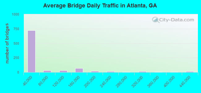
- 46,196,877Total average daily traffic
- 629,964Total average daily truck traffic
- National Bridge Inventory (NBI) Registered Bridges for Atlanta
- No street view available for this location
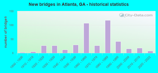
- New bridges - historical statistics
- 31900-1909
- 51910-1919
- 271920-1929
- 271930-1939
- 121940-1949
- 301950-1959
- 1071960-1969
- 271970-1979
- 1181980-1989
- 421990-1999
- 162000-2009
- 182010-2019
- 82020-2022
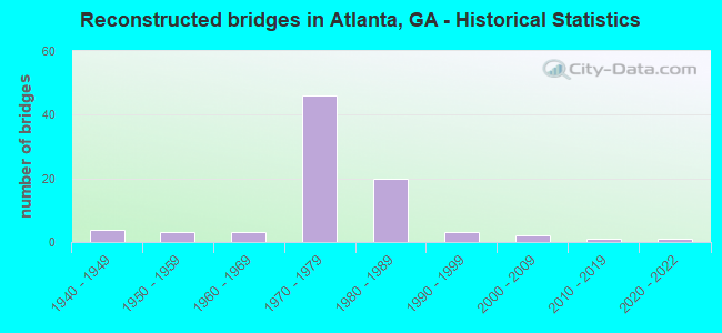
- Reconstructed bridges - Historical Statistics
- 41940-1949
- 31950-1959
- 31960-1969
- 461970-1979
- 201980-1989
- 31990-1999
- 22000-2009
- 12010-2019
- 12020-2022
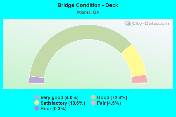
- Bridge Condition - Deck
- 4.0%Very good
- 72.6%Good
- 18.6%Satisfactory
- 4.5%Fair
- 0.3%Poor
- Bridge Condition - Superstructure
- 26.1%Very good
- 59.6%Good
- 8.8%Satisfactory
- 4.5%Fair
- 1.1%Poor
- 0.3%Imminent failure
- Bridge Condition - Substructure
- 0.3%Excellent
- 4.3%Very good
- 79.5%Good
- 11.2%Satisfactory
- 4.8%Fair
- Bridge Condition - Channel
- 3.5%Excellent
- 36.0%Very good
- 34.3%Good
- 19.2%Satisfactory
- 5.8%Fair
- 1.2%Poor
- Bridge Condition - Culverts
- 73.3%Good
- 21.7%Satisfactory
- 5.0%Fair
Find on map >> Show street view
Structure Number: 1210668, Location: IN ATLANTA (Lat: 33.737414, Lng: -84.391906), Route carried "under" structure: City street 9163, Structure Length: 0. m, Average Daily Traffic: 2,000 (year 1996), Truck Traffic: 1%, Features Intersected: I-75 RAMP NB TO CENTRAL, Facility Carried by Structure: I-75R NB TO CENTRA
Minimum Vertical Clearance: 8.83m (28.97ft), Kilometerpoint: 0.000, Lanes on structure: 2, Length of Maximum Span: 0.0m
Find on map >> Show street view
Structure Number: 1210668, Location: IN ATLANTA (Lat: 33.737414, Lng: -84.391906), Route carried "under" structure: Interstate 75, Structure Length: 0. m, Average Daily Traffic: 316,000 (year 1998), Truck Traffic: 1%, Features Intersected: I-75 RAMP NB TO CENTRAL
Minimum Vertical Clearance: 5.94m (19.49ft), Kilometerpoint: 395.899, Lanes on structure: 2, Length of Maximum Span: 0.0m
Find on map >> Show street view
Structure Number: 1210668, Location: IN ATLANTA (Lat: 33.737414, Lng: -84.391906), Route carried "under" structure: City street 9053, Structure Length: 0. m, Average Daily Traffic: 20,977 (year 1995), Truck Traffic: 1%, Features Intersected: I-75 RAMP NB TO CENTRAL, Facility Carried by Structure: I-75R NB TO CENTRA
Minimum Vertical Clearance: 12.80m (41.99ft), Kilometerpoint: 17.703, Lanes on structure: 2, Length of Maximum Span: 0.0m
Find on map >> Show street view
Structure Number: 1210668, Location: IN ATLANTA (Lat: 33.737414, Lng: -84.391906), Route carried "under" structure: Ramp Interstate 75, Structure Length: 0. m, Average Daily Traffic: 10,000 (year 1996), Truck Traffic: 1%, Features Intersected: I-75 RAMP NB TO CENTRAL
Minimum Vertical Clearance: 5.99m (19.65ft), Kilometerpoint: 395.899, Lanes on structure: 2, Length of Maximum Span: 0.0m
Find on map >> Show street view
Structure Number: 1210669, Location: IN ATLANTA (Lat: 33.736839, Lng: -84.391228), Route carried "under" structure: City street 9053, Structure Length: 0. m, Average Daily Traffic: 20,977 (year 1998), Truck Traffic: 1%, Features Intersected: I-75 RMP NB TO FULTON ST, Facility Carried by Structure: I-75R NB TO FULTON
Minimum Vertical Clearance: 13.71m (44.98ft), Kilometerpoint: 17.703, Lanes on structure: 1, Length of Maximum Span: 0.0m
Find on map >> Show street view
Structure Number: 1210672, Location: IN BUCKHEAD (Lat: 33.846550, Lng: -84.356539), Route carried "under" structure: City street 9013, Structure Length: 0. m, Average Daily Traffic: 5,850 (year 2011), Truck Traffic: 1%, Features Intersected: M-9013 E PACES FERRY RD., Facility Carried by Structure: PED. BRIDGE
Minimum Vertical Clearance: 5.79m (19.00ft), Kilometerpoint: 19.312, Length of Maximum Span: 0.0m
Find on map >> Show street view
Structure Number: 1210682, Location: IN CITY OF ATLANTA (Lat: 33.774558, Lng: -84.383169), Route carried "under" structure: City street 9007, Structure Length: 0. m, Average Daily Traffic: 12,500 (year 2011), Truck Traffic: 1%, Features Intersected: M-9007 JUNIPER STREET, Facility Carried by Structure: PED. BRIDGE
Minimum Vertical Clearance: 7.82m (25.66ft), Kilometerpoint: 6.437, Length of Maximum Span: 0.0m
Find on map >> Show street view
Structure Number: 1210684, Location: IN CITY OF ATLANTA (Lat: 33.760508, Lng: -84.389328), Route carried "under" structure: City street 9073, Structure Length: 0. m, Average Daily Traffic: 15,520 (year 2003), Truck Traffic: 6%, Features Intersected: M-9073 SPRING STREET, Facility Carried by Structure: PED. BRIDGE
Minimum Vertical Clearance: 6.65m (21.82ft), Kilometerpoint: 1.609, Length of Maximum Span: 0.0m
Find on map >> Show street view
Structure Number: 1210685, Location: IN ATLANTA (Lat: 33.770319, Lng: -84.388908), Route carried "under" structure: City street 9073, Structure Length: 0. m, Average Daily Traffic: 14,451 (year 2003), Truck Traffic: 1%, Features Intersected: M-9073 SPRING STREET, Facility Carried by Structure: PED. BRIDGE
Minimum Vertical Clearance: 7.08m (23.23ft), Kilometerpoint: 3.219, Length of Maximum Span: 0.0m
Find on map >> Show street view
Structure Number: 1210688, Location: IN CITY OF ATLANTA (Lat: 33.761039, Lng: -84.389150), Route carried "under" structure: City street 9154, Structure Length: 0. m, Average Daily Traffic: 4,500 (year 2011), Truck Traffic: 1%, Features Intersected: M-9154 HARRIS & SPRING, Facility Carried by Structure: PED. BRIDGE
Minimum Vertical Clearance: 6.62m (21.72ft), Kilometerpoint: 0.000, Length of Maximum Span: 0.0m
Find on map >> Show street view
Structure Number: 1210689, Location: IN CITY OF ATLANTA (Lat: 33.760989, Lng: -84.389708), Route carried "under" structure: City street 9154, Structure Length: 0. m, Average Daily Traffic: 4,530 (year 2007), Truck Traffic: 1%, Features Intersected: M-9154 HARRIS STREET, Facility Carried by Structure: PED. BRIDGE
Minimum Vertical Clearance: 5.74m (18.83ft), Kilometerpoint: 0.000, Length of Maximum Span: 0.0m
Find on map >> Show street view
Structure Number: 121069, Location: IN CITY OF ATLANTA (Lat: 33.760958, Lng: -84.386039), Route carried "under" structure: City street 9154, Structure Length: 0. m, Average Daily Traffic: 4,500 (year 2011), Truck Traffic: 1%, Features Intersected: M-9154 HARRIS/P'TREE CNT, Facility Carried by Structure: PED. BRIDGE
Minimum Vertical Clearance: 6.47m (21.23ft), Kilometerpoint: 0.000, Length of Maximum Span: 0.0m
Find on map >> Show street view
Structure Number: 1210691, Location: IN CITY OF ATLANTA (Lat: 33.759678, Lng: -84.388800), Route carried "under" structure: City street 9155, Structure Length: 0. m, Average Daily Traffic: 6,620 (year 2011), Truck Traffic: 1%, Features Intersected: M-9155 INTERNATION BLVD., Facility Carried by Structure: PED. BRIDGE
Minimum Vertical Clearance: 6.45m (21.16ft), Kilometerpoint: 0.000, Length of Maximum Span: 0.0m
Find on map >> Show street view
Structure Number: 1210692, Location: IN CITY OF ATLANTA (Lat: 33.762669, Lng: -84.386008), Route carried "under" structure: City street 9164, Structure Length: 0. m, Average Daily Traffic: 6,800 (year 2007), Truck Traffic: 1%, Features Intersected: M-9164 P'TREE CENTER, Facility Carried by Structure: PED. BRIDGE
Minimum Vertical Clearance: 7.89m (25.89ft), Kilometerpoint: 3.219, Length of Maximum Span: 0.0m
Find on map >> Show street view
Structure Number: 1210693, Location: IN CITY OF ATLANTA (Lat: 33.760608, Lng: -84.386047), Route carried "under" structure: City street 1868, Structure Length: 0. m, Average Daily Traffic: 16,020 (year 2011), Truck Traffic: 1%, Features Intersected: PEDESTRIAN BRIDGE, Facility Carried by Structure: PED. BRIDGE
Minimum Vertical Clearance: 12.19m (39.99ft), Kilometerpoint: 5.407, Toll: Toll bridge, Length of Maximum Span: 0.0m
Find on map >> Show street view
Structure Number: 1210693, Location: IN CITY OF ATLANTA (Lat: 33.760608, Lng: -84.386047), Route carried "under" structure: City street 9164, Structure Length: 0. m, Average Daily Traffic: 6,800 (year 2007), Truck Traffic: 1%, Features Intersected: M-9164 P'TREE CENTER, Facility Carried by Structure: PED. BRIDGE
Minimum Vertical Clearance: 5.15m (16.90ft), Kilometerpoint: 3.219, Length of Maximum Span: 0.0m
Find on map >> Show street view
Structure Number: 1210694, Location: IN ATLANTA (Lat: 33.761908, Lng: -84.390558), Route carried "under" structure: City street 9200, Structure Length: 0. m, Average Daily Traffic: 12,150 (year 2011), Truck Traffic: 1%, Features Intersected: M-9200 WILLIAMS STREET, Facility Carried by Structure: PED. BRIDGE
Minimum Vertical Clearance: 6.19m (20.31ft), Kilometerpoint: 1.609, Length of Maximum Span: 0.0m
Find on map >> Show street view
Structure Number: 1210695, Location: IN ATLANTA (Lat: 33.761378, Lng: -84.390600), Route carried "under" structure: City street 9200, Structure Length: 0. m, Average Daily Traffic: 1,250 (year 2007), Truck Traffic: 1%, Features Intersected: M-9200 WILLIAMS STREET, Facility Carried by Structure: PED. BRIDGE
Minimum Vertical Clearance: 6.70m (21.98ft), Kilometerpoint: 1.609, Length of Maximum Span: 0.0m
Find on map >> Show street view
Structure Number: 1210699, Location: IN ATLANTA (Lat: 33.741450, Lng: -84.391169), Route carried "under" structure: Ramp Interstate 75, Structure Length: 0. m, Average Daily Traffic: 10,000 (year 1999), Truck Traffic: 1%, Features Intersected: I-75 NB RMP TO FULTON ST
Minimum Vertical Clearance: 8.43m (27.66ft), Kilometerpoint: 395.899, Lanes on structure: 3, Length of Maximum Span: 0.0m
Find on map >> Show street view
Structure Number: 12107, Location: IN ATLANTA (Lat: 33.742258, Lng: -84.391158), Route carried "under" structure: Ramp Interstate 75, Structure Length: 0. m, Average Daily Traffic: 9,000 (year 1995), Truck Traffic: 1%, Features Intersected: FULTON ST RMP TO I75 NB
Minimum Vertical Clearance: 6.80m (22.31ft), Kilometerpoint: 395.899, Lanes on structure: 2, Length of Maximum Span: 0.0m
Find on map >> Show street view
Structure Number: 1210701, Location: IN ATLANTA (Lat: 33.742600, Lng: -84.392158), Route carried "under" structure: Ramp Interstate 75, Structure Length: 0. m, Average Daily Traffic: 7,350 (year 1999), Truck Traffic: 1%, Features Intersected: I-75 NB RMP FROM FULTON
Minimum Vertical Clearance: 6.75m (22.15ft), Kilometerpoint: 395.899, Lanes on structure: 3, Length of Maximum Span: 0.0m
Find on map >> Show street view
Structure Number: 1210702, Location: IN ATLANTA (Lat: 33.743789, Lng: -84.391839), Route carried "under" structure: Interstate 75, Structure Length: 0. m, Average Daily Traffic: 232,500 (year 1998), Truck Traffic: 1%, Features Intersected: I-75 NB RM TO CENTRAL AV
Minimum Vertical Clearance: 10.87m (35.66ft), Kilometerpoint: 395.899, Lanes on structure: 1, Length of Maximum Span: 0.0m
Find on map >> Show street view
Structure Number: 1210702, Location: IN ATLANTA (Lat: 33.743789, Lng: -84.391839), Route carried "under" structure: Ramp Interstate 75, Structure Length: 0. m, Average Daily Traffic: 2,000 (year 1994), Truck Traffic: 1%, Features Intersected: I-75 NB RM TO CENTRAL AV
Minimum Vertical Clearance: 10.21m (33.50ft), Kilometerpoint: 395.899, Lanes on structure: 1, Length of Maximum Span: 0.0m
Find on map >> Show street view
Structure Number: 1210702, Location: IN ATLANTA (Lat: 33.743789, Lng: -84.391839), Route carried "under" structure: Ramp Interstate 20, Structure Length: 0. m, Average Daily Traffic: 2,000 (year 1996), Truck Traffic: 1%, Features Intersected: I-75 NB RM TO CENTRAL AV, Facility Carried by Structure: I-75 RMP N TO M916
Minimum Vertical Clearance: 5.48m (17.98ft), Kilometerpoint: 91.733, Lanes on structure: 1, Length of Maximum Span: 0.0m
Find on map >> Show street view
Structure Number: 1210702, Location: IN ATLANTA (Lat: 33.743789, Lng: -84.391839), Route carried "under" structure: City street 9163, Structure Length: 0. m, Average Daily Traffic: 11,140 (year 1995), Truck Traffic: 1%, Features Intersected: I-75 NB RM TO CENTRAL AV, Facility Carried by Structure: I-75 RMP N TO M916
Minimum Vertical Clearance: 8.33m (27.33ft), Kilometerpoint: 1.609, Lanes on structure: 1, Length of Maximum Span: 0.0m
Find on map >> Show street view
Structure Number: 1210703, Location: I-20 & I-75 INTERCHANGE (Lat: 33.743881, Lng: -84.391969), Route carried "under" structure: City street 9164, Structure Length: 0. m, Average Daily Traffic: 19,090 (year 1995), Truck Traffic: 1%, Features Intersected: I-75 SB RMP FROM PRYOR, Facility Carried by Structure: PRYOR ST TO I-75 S
Minimum Vertical Clearance: 6.55m (21.49ft), Kilometerpoint: 1.609, Lanes on structure: 1, Length of Maximum Span: 0.0m
Find on map >> Show street view
Structure Number: 1210703, Location: I-20 & I-75 INTERCHANGE (Lat: 33.743881, Lng: -84.391969), Route carried "under" structure: Ramp Interstate 20, Structure Length: 0. m, Average Daily Traffic: 10,000 (year 1994), Truck Traffic: 1%, Features Intersected: I-75 SB RMP FROM PRYOR, Facility Carried by Structure: PRYOR ST TO I-75 S
Minimum Vertical Clearance: 5.89m (19.32ft), Kilometerpoint: 91.733, Lanes on structure: 1, Length of Maximum Span: 0.0m
Find on map >> Show street view
Structure Number: 1210703, Location: I-20 & I-75 INTERCHANGE (Lat: 33.743881, Lng: -84.391969), Route carried "under" structure: Ramp Interstate 75, Structure Length: 0. m, Average Daily Traffic: 2,000 (year 1996), Truck Traffic: 1%, Features Intersected: I-75 SB RMP FROM PRYOR
Minimum Vertical Clearance: 8.35m (27.40ft), Kilometerpoint: 395.899, Lanes on structure: 1, Length of Maximum Span: 0.0m
Find on map >> Show street view
Structure Number: 1210703, Location: I-20 & I-75 INTERCHANGE (Lat: 33.743881, Lng: -84.391969), Route carried "under" structure: Interstate 75, Structure Length: 0. m, Average Daily Traffic: 232,500 (year 1998), Truck Traffic: 1%, Features Intersected: I-75 SB RMP FROM PRYOR
Minimum Vertical Clearance: 8.22m (26.97ft), Kilometerpoint: 395.899, Lanes on structure: 1, Length of Maximum Span: 0.0m
Find on map >> Show street view
Structure Number: 1210703, Location: I-20 & I-75 INTERCHANGE (Lat: 33.743881, Lng: -84.391969), Route carried "under" structure: City street 9163, Structure Length: 0. m, Average Daily Traffic: 2,000 (year 1995), Truck Traffic: 1%, Features Intersected: I-75 SB RMP FROM PRYOR, Facility Carried by Structure: PRYOR ST TO I-75 S
Minimum Vertical Clearance: 11.58m (37.99ft), Kilometerpoint: 1.609, Lanes on structure: 1, Length of Maximum Span: 0.0m
Find on map >> Show street view
Structure Number: 1210704, Location: I-20 & I-75 INTERCHANGE (Lat: 33.744725, Lng: -84.390200), Route carried "under" structure: Ramp Interstate 75, Structure Length: 0. m, Average Daily Traffic: 9,000 (year 1996), Truck Traffic: 1%, Features Intersected: I-75 NB RMP TO I-20 WB
Minimum Vertical Clearance: 6.47m (21.23ft), Kilometerpoint: 395.899, Lanes on structure: 1, Length of Maximum Span: 0.0m
Find on map >> Show street view
Structure Number: 1210704, Location: I-20 & I-75 INTERCHANGE (Lat: 33.744725, Lng: -84.390200), Route carried "under" structure: Ramp Interstate 75, Structure Length: 0. m, Average Daily Traffic: 1,710 (year 1995), Truck Traffic: 1%, Features Intersected: I-75 NB RMP TO I-20 WB
Minimum Vertical Clearance: 11.91m (39.07ft), Kilometerpoint: 395.899, Lanes on structure: 1, Length of Maximum Span: 0.0m
Find on map >> Show street view
Structure Number: 1210704, Location: I-20 & I-75 INTERCHANGE (Lat: 33.744725, Lng: -84.390200), Route carried "under" structure: Interstate 75, Structure Length: 0. m, Average Daily Traffic: 316,000 (year 1998), Truck Traffic: 1%, Features Intersected: I-75 NB RMP TO I-20 WBL
Minimum Vertical Clearance: 9.11m (29.89ft), Kilometerpoint: 395.899, Lanes on structure: 1, Length of Maximum Span: 0.0m
Find on map >> Show street view
Structure Number: 1210704, Location: I-20 & I-75 INTERCHANGE (Lat: 33.744725, Lng: -84.390200), Route carried "under" structure: Ramp Interstate 20, Structure Length: 0. m, Average Daily Traffic: 10,000 (year 1994), Truck Traffic: 1%, Features Intersected: I-75 NB RMP TO I-20 WB
Minimum Vertical Clearance: 5.91m (19.39ft), Kilometerpoint: 91.733, Lanes on structure: 1, Length of Maximum Span: 0.0m
Find on map >> Show street view
Structure Number: 1210705, Location: I-20 & I-75 INTERCHANGE (Lat: 33.745078, Lng: -84.390131), Route carried "under" structure: Ramp Interstate 75, Structure Length: 0. m, Average Daily Traffic: 10,000 (year 1995), Truck Traffic: 1%, Features Intersected: I-75 SB RMP TO I-20 EB
Minimum Vertical Clearance: 8.35m (27.40ft), Kilometerpoint: 395.899, Lanes on structure: 1, Length of Maximum Span: 0.0m
Find on map >> Show street view
Structure Number: 1210705, Location: I-20 & I-75 INTERCHANGE (Lat: 33.745078, Lng: -84.390131), Route carried "under" structure: Interstate 75, Structure Length: 0. m, Average Daily Traffic: 316,000 (year 1998), Truck Traffic: 1%, Features Intersected: I-75 SB RMP TO I-20 EB
Minimum Vertical Clearance: 6.90m (22.64ft), Kilometerpoint: 395.899, Lanes on structure: 1, Length of Maximum Span: 0.0m
Find on map >> Show street view
Structure Number: 1210705, Location: I-20 & I-75 INTERCHANGE (Lat: 33.745078, Lng: -84.390131), Route carried "under" structure: Ramp Interstate 75, Structure Length: 0. m, Average Daily Traffic: 10,000 (year 1996), Truck Traffic: 1%, Features Intersected: I-75 SB RMP TO I-20 EB
Minimum Vertical Clearance: 6.12m (20.08ft), Kilometerpoint: 395.899, Lanes on structure: 1, Length of Maximum Span: 0.0m
Find on map >> Show street view
Structure Number: 1210705, Location: I-20 & I-75 INTERCHANGE (Lat: 33.745078, Lng: -84.390131), Route carried "under" structure: Ramp Interstate 20, Structure Length: 0. m, Average Daily Traffic: 15,000 (year 1994), Truck Traffic: 1%, Features Intersected: I-75 SB RMP TO I-20 EB, Facility Carried by Structure: I-75 SB RMP TO I-2
Minimum Vertical Clearance: 5.58m (18.31ft), Kilometerpoint: 91.733, Lanes on structure: 1, Length of Maximum Span: 0.0m
Find on map >> Show street view
Structure Number: 1210706, Location: I-75 & I-20 INTERCHANGE (Lat: 33.745800, Lng: -84.393869), Route carried "under" structure: City street 9164, Structure Length: 0. m, Average Daily Traffic: 20,810 (year 1998), Truck Traffic: 1%, Features Intersected: I-75 RMP N&S TO I-20 WB, Facility Carried by Structure: I-75 RMP TO I-20WB
Minimum Vertical Clearance: 9.88m (32.41ft), Kilometerpoint: 1.609, Lanes on structure: 1, Length of Maximum Span: 0.0m
Find on map >> Show street view
Structure Number: 1210706, Location: I-75 & I-20 INTERCHANGE (Lat: 33.745800, Lng: -84.393869), Route carried "under" structure: Ramp City street 9164, Structure Length: 0. m, Average Daily Traffic: 1,000 (year 1996), Truck Traffic: 1%, Features Intersected: I-75 RMP N&SB TO I-20 WB, Facility Carried by Structure: I-75 RMP TO I-20WB
Minimum Vertical Clearance: 9.27m (30.41ft), Kilometerpoint: 1.609, Lanes on structure: 1, Length of Maximum Span: 0.0m
Find on map >> Show street view
Structure Number: 1210706, Location: I-75 & I-20 INTERCHANGE (Lat: 33.745800, Lng: -84.393869), Route carried "under" structure: City street 9166, Structure Length: 0. m, Average Daily Traffic: 14,000 (year 1989), Truck Traffic: 1%, Features Intersected: I-75 RMP N&S TO I-20 WB, Facility Carried by Structure: I-75 RMP TO I-20WB
Minimum Vertical Clearance: 9.85m (32.32ft), Kilometerpoint: 6.437, Lanes on structure: 1, Length of Maximum Span: 0.0m
Find on map >> Show street view
Structure Number: 1210706, Location: I-75 & I-20 INTERCHANGE (Lat: 33.745800, Lng: -84.393869), Route carried "under" structure: Ramp City street 9166, Structure Length: 0. m, Average Daily Traffic: 1,000 (year 1989), Truck Traffic: 1%, Features Intersected: I-75 RMP N&SB TO I-20 WB, Facility Carried by Structure: I-75 RMP TO I-20WB
Minimum Vertical Clearance: 9.29m (30.48ft), Kilometerpoint: 6.437, Lanes on structure: 1, Length of Maximum Span: 0.0m
Find on map >> Show street view
Structure Number: 1210707, Location: IN ATLANTA (Lat: 33.744878, Lng: -84.396989), Route carried "under" structure: Ramp Interstate 20, Structure Length: 0. m, Average Daily Traffic: 7,000 (year 1999), Truck Traffic: 1%, Features Intersected: I-20 EB RMP TO I-75 N&SB
Minimum Vertical Clearance: 5.33m (17.49ft), Kilometerpoint: 91.733, Lanes on structure: 3, Length of Maximum Span: 0.0m
Find on map >> Show street view
Structure Number: 1210708, Location: IN ATLANTA (Lat: 33.746908, Lng: -84.387628), Route carried "under" structure: Ramp Interstate 20, Structure Length: 0. m, Average Daily Traffic: 25,000 (year 1996), Truck Traffic: 1%, Features Intersected: SR 154 MEMORIAL DRIVE, Facility Carried by Structure: MEMORIAL DRIVE
Minimum Vertical Clearance: 5.38m (17.65ft), Kilometerpoint: 91.733, Lanes on structure: 5, Length of Maximum Span: 0.0m
Find on map >> Show street view
Structure Number: 1210708, Location: IN ATLANTA (Lat: 33.746908, Lng: -84.387628), Route carried "under" structure: Interstate 75, Structure Length: 0. m, Average Daily Traffic: 357,700 (year 1999), Truck Traffic: 1%, Features Intersected: SR 154 MEMORIAL DRIVE, Facility Carried by Structure: MEMORIAL DRIVE
Minimum Vertical Clearance: 5.79m (19.00ft), Kilometerpoint: 397.508, Lanes on structure: 5, Length of Maximum Span: 0.0m
Find on map >> Show street view
Structure Number: 1210708, Location: IN ATLANTA (Lat: 33.746908, Lng: -84.387628), Route carried "under" structure: Ramp Interstate 75, Structure Length: 0. m, Average Daily Traffic: 30,000 (year 1996), Truck Traffic: 1%, Features Intersected: SR 154 MEMORIAL DRIVE, Facility Carried by Structure: MEMORIAL DRIVE
Minimum Vertical Clearance: 5.81m (19.06ft), Kilometerpoint: 397.508, Lanes on structure: 5, Length of Maximum Span: 0.0m
Find on map >> Show street view
Structure Number: 1210709, Location: IN ATLANTA (Lat: 33.748328, Lng: -84.385350), Route carried "under" structure: Interstate 75, Structure Length: 0. m, Average Daily Traffic: 406,200 (year 1998), Truck Traffic: 1%, Features Intersected: M-9134 M.L.K. JR. DRIVE, Facility Carried by Structure: M.L.K. JR. DRIVE
Minimum Vertical Clearance: 6.75m (22.15ft), Kilometerpoint: 397.508, Lanes on structure: 4, Length of Maximum Span: 0.0m
Find on map >> Show street view
Structure Number: 121071, Location: IN ATLANTA (Lat: 33.748589, Lng: -84.383389), Route carried "under" structure: Ramp Interstate 75, Structure Length: 0. m, Average Daily Traffic: 10,750 (year 2012), Truck Traffic: 1%, Features Intersected: I-75 RAMP, Facility Carried by Structure: UTILITY BRIDGE
Minimum Vertical Clearance: 5.18m (16.99ft), Kilometerpoint: 397.508, Length of Maximum Span: 0.0m
Find on map >> Show street view
Structure Number: 1210711, Location: IN ATLANTA (Lat: 33.748389, Lng: -84.384839), Route carried "under" structure: Interstate 75, Structure Length: 0. m, Average Daily Traffic: 335,210 (year 2012), Truck Traffic: 1%, Features Intersected: I-75, Facility Carried by Structure: UTILITY BRIDGE
Minimum Vertical Clearance: 9.14m (29.99ft), Kilometerpoint: 397.508, Length of Maximum Span: 0.0m
Find on map >> Show street view
Structure Number: 1210712, Location: IN ATLANTA (Lat: 33.749078, Lng: -84.384050), Route carried "under" structure: Ramp Interstate 75, Structure Length: 0. m, Average Daily Traffic: 6,530 (year 2010), Truck Traffic: 1%, Features Intersected: I-75 RAMP, Facility Carried by Structure: UTILITY BRIDGE
Minimum Vertical Clearance: 6.52m (21.39ft), Kilometerpoint: 397.508, Length of Maximum Span: 0.0m
Find on map >> Show street view
Structure Number: 1210713, Location: IN ATLANTA (Lat: 33.748908, Lng: -84.382819), Route carried "under" structure: Ramp Interstate 75, Structure Length: 0. m, Average Daily Traffic: 10,540 (year 2010), Truck Traffic: 1%, Features Intersected: I-75 RAMP, Facility Carried by Structure: NORFOLK SOUTHERN R
Minimum Vertical Clearance: 5.89m (19.32ft), Kilometerpoint: 397.508, Length of Maximum Span: 0.0m
Find on map >> Show street view
Structure Number: 1210714, Location: IN N ATLANTA (Lat: 33.749078, Lng: -84.383339), Route carried "under" structure: Interstate 75, Structure Length: 0. m, Average Daily Traffic: 335,210 (year 2012), Truck Traffic: 1%, Features Intersected: I-75, Facility Carried by Structure: NORFOLK SOUTHERN R
Minimum Vertical Clearance: 7.11m (23.33ft), Kilometerpoint: 397.508, Length of Maximum Span: 0.0m
Find on map >> Show street view
Structure Number: 1210715, Location: IN ATLANTA (Lat: 33.749239, Lng: -84.383808), Route carried "under" structure: Ramp Interstate 75, Structure Length: 0. m, Average Daily Traffic: 7,510 (year 2007), Truck Traffic: 1%, Features Intersected: I-75 RAMP, Facility Carried by Structure: NORFOLK SOUTHERN R
Minimum Vertical Clearance: 7.16m (23.49ft), Kilometerpoint: 397.508, Length of Maximum Span: 0.0m
Find on map >> Show street view
Structure Number: 1210716, Location: IN ATLANTA (Lat: 33.758092, Lng: -84.378061), Route carried "under" structure: City street 9157, Structure Length: 0. m, Average Daily Traffic: 11,370 (year 1998), Truck Traffic: 1%, Features Intersected: I-75 RMP NB TO SR 410 EB, Facility Carried by Structure: I-75R N TO SR 10
Minimum Vertical Clearance: 5.74m (18.83ft), Kilometerpoint: 1.609, Lanes on structure: 2, Length of Maximum Span: 0.0m
Find on map >> Show street view
Structure Number: 1210716, Location: IN ATLANTA (Lat: 33.758092, Lng: -84.378061), Route carried "under" structure: Ramp Interstate 75, Structure Length: 0. m, Average Daily Traffic: 9,000 (year 1996), Truck Traffic: 1%, Features Intersected: I-75R N TO SR 10 EB
Minimum Vertical Clearance: 5.30m (17.39ft), Kilometerpoint: 399.118, Lanes on structure: 2, Length of Maximum Span: 0.0m
Find on map >> Show street view
Structure Number: 1210717, Location: IN ATLANTA (Lat: 33.759056, Lng: -84.379567), Route carried "under" structure: Ramp Interstate 75, Structure Length: 0. m, Average Daily Traffic: 10,000 (year 1996), Truck Traffic: 1%, Features Intersected: SR 10 RAMP WB TO I-75 SB
Minimum Vertical Clearance: 6.07m (19.91ft), Kilometerpoint: 399.118, Lanes on structure: 2, Length of Maximum Span: 0.0m
Find on map >> Show street view
Structure Number: 1210717, Location: IN ATLANTA (Lat: 33.759056, Lng: -84.379567), Route carried "under" structure: Ramp State highway 10, Structure Length: 0. m, Average Daily Traffic: 11,140 (year 1995), Truck Traffic: 1%, Features Intersected: SR 10 RAMP WB TO I-75 SB
Minimum Vertical Clearance: 5.81m (19.06ft), Kilometerpoint: 0.000, Lanes on structure: 2, Length of Maximum Span: 0.0m
Find on map >> Show street view
Structure Number: 1210717, Location: IN ATLANTA (Lat: 33.759056, Lng: -84.379567), Route carried "under" structure: Ramp Interstate 75, Structure Length: 0. m, Average Daily Traffic: 10,000 (year 1996), Truck Traffic: 1%, Features Intersected: SR 10 RAMP WB TO I-75 SB
Minimum Vertical Clearance: 9.27m (30.41ft), Kilometerpoint: 399.118, Lanes on structure: 2, Length of Maximum Span: 0.0m
Find on map >> Show street view
Structure Number: 1210717, Location: IN ATLANTA (Lat: 33.759056, Lng: -84.379567), Route carried "under" structure: Ramp Interstate 75, Structure Length: 0. m, Average Daily Traffic: 10,000 (year 1995), Truck Traffic: 1%, Features Intersected: SR 10 RAMP WB TO I-75 SB
Minimum Vertical Clearance: 5.71m (18.73ft), Kilometerpoint: 399.118, Lanes on structure: 2, Length of Maximum Span: 0.0m
Find on map >> Show street view
Structure Number: 1210717, Location: IN ATLANTA (Lat: 33.759056, Lng: -84.379567), Route carried "under" structure: Ramp Interstate 75, Structure Length: 0. m, Average Daily Traffic: 11,140 (year 2006), Features Intersected: JOHN WESLEY DOBBS AVE
Minimum Vertical Clearance: 13.56m (44.49ft), Kilometerpoint: 399.118, Lanes on structure: 2, Length of Maximum Span: 0.0m
Find on map >> Show street view
Structure Number: 1210717, Location: IN ATLANTA (Lat: 33.759056, Lng: -84.379567), Route carried "under" structure: Interstate 75, Structure Length: 0. m, Average Daily Traffic: 391,400 (year 1999), Truck Traffic: 1%, Features Intersected: SR 10 RAMP WB TO I-75 SB
Minimum Vertical Clearance: 16.66m (54.66ft), Kilometerpoint: 399.118, Lanes on structure: 2, Length of Maximum Span: 0.0m
Find on map >> Show street view
Structure Number: 1210718, Location: IN ATLANTA (Lat: 33.758378, Lng: -84.380128), Route carried "under" structure: Ramp Interstate 75, Structure Length: 0. m, Average Daily Traffic: 10,000 (year 1999), Truck Traffic: 1%, Features Intersected: I-75 RAMP TO I-75 SB
Minimum Vertical Clearance: 8.40m (27.56ft), Kilometerpoint: 399.118, Lanes on structure: 1, Length of Maximum Span: 0.0m
Find on map >> Show street view
Structure Number: 1210719, Location: IN ATLANTA (Lat: 33.758981, Lng: -84.379328), Route carried "under" structure: Ramp Interstate 75, Structure Length: 0. m, Average Daily Traffic: 1,000 (year 1994), Truck Traffic: 1%, Features Intersected: SR 10 RAMP EBL, Facility Carried by Structure: SR 10 (EBL) BR 7E
Minimum Vertical Clearance: 6.37m (20.90ft), Kilometerpoint: 399.118, Lanes on structure: 4, Length of Maximum Span: 0.0m
Find on map >> Show street view
Structure Number: 1210719, Location: IN ATLANTA (Lat: 33.758981, Lng: -84.379328), Route carried "under" structure: Ramp Interstate 75, Structure Length: 0. m, Average Daily Traffic: 1,000 (year 1994), Truck Traffic: 1%, Features Intersected: SR 10 RAMP SB, Facility Carried by Structure: SR 10 (EBL) BR 7E
Minimum Vertical Clearance: 4.72m (15.49ft), Kilometerpoint: 399.118, Lanes on structure: 4, Length of Maximum Span: 0.0m
Find on map >> Show street view
Structure Number: 1210719, Location: IN ATLANTA (Lat: 33.758981, Lng: -84.379328), Route carried "under" structure: Ramp Interstate 75, Structure Length: 0. m, Average Daily Traffic: 10,000 (year 1994), Truck Traffic: 1%, Features Intersected: SR 10 RAMP EBL, Facility Carried by Structure: SR 10 (EBL) BR 7E
Minimum Vertical Clearance: 8.48m (27.82ft), Kilometerpoint: 399.118, Lanes on structure: 4, Length of Maximum Span: 0.0m
Find on map >> Show street view
Structure Number: 1210719, Location: IN ATLANTA (Lat: 33.758981, Lng: -84.379328), Route carried "under" structure: Interstate 75, Structure Length: 0. m, Average Daily Traffic: 415,300 (year 1999), Truck Traffic: 1%, Features Intersected: SR 10 RAMP EBL, Facility Carried by Structure: SR 10 (EBL) BR 7E
Minimum Vertical Clearance: 7.44m (24.41ft), Kilometerpoint: 399.118, Lanes on structure: 4, Length of Maximum Span: 0.0m
Find on map >> Show street view
Structure Number: 121072, Location: IN ATLANTA (Lat: 33.759478, Lng: -84.378878), Route carried "under" structure: Interstate 75, Structure Length: 0. m, Average Daily Traffic: 391,400 (year 1999), Truck Traffic: 1%, Features Intersected: I-75 RMP SB TO SR 10 EB
Minimum Vertical Clearance: 12.54m (41.14ft), Kilometerpoint: 399.118, Lanes on structure: 2, Length of Maximum Span: 0.0m
Find on map >> Show street view
Structure Number: 121072, Location: IN ATLANTA (Lat: 33.759478, Lng: -84.378878), Route carried "under" structure: Ramp Interstate 75, Structure Length: 0. m, Average Daily Traffic: 1,000 (year 1994), Truck Traffic: 1%, Features Intersected: I-75 RMP SB TO SR 10 EB
Minimum Vertical Clearance: 10.84m (35.56ft), Kilometerpoint: 399.118, Lanes on structure: 2, Length of Maximum Span: 0.0m
Find on map >> Show street view
Structure Number: 121072, Location: IN ATLANTA (Lat: 33.759478, Lng: -84.378878), Route carried "under" structure: Ramp Interstate 75, Structure Length: 0. m, Average Daily Traffic: 10,000 (year 1996), Truck Traffic: 1%, Features Intersected: I-75 RMP SB TO SR 10 EB
Minimum Vertical Clearance: 7.82m (25.66ft), Kilometerpoint: 399.118, Lanes on structure: 2, Length of Maximum Span: 0.0m
Find on map >> Show street view
Structure Number: 121072, Location: IN ATLANTA (Lat: 33.759478, Lng: -84.378878), Route carried "under" structure: Ramp Interstate 75, Structure Length: 0. m, Average Daily Traffic: 1,000 (year 1994), Truck Traffic: 1%, Features Intersected: I-75 RMP SB TO SR 10 EB
Minimum Vertical Clearance: 8.76m (28.74ft), Kilometerpoint: 399.118, Lanes on structure: 2, Length of Maximum Span: 0.0m
Find on map >> Show street view
Structure Number: 121072, Location: IN ATLANTA (Lat: 33.759478, Lng: -84.378878), Route carried "under" structure: Ramp Interstate 75, Structure Length: 0. m, Average Daily Traffic: 10,000 (year 1995), Truck Traffic: 1%, Features Intersected: I-75 RMP SB TO SR 10 EB
Minimum Vertical Clearance: 5.74m (18.83ft), Kilometerpoint: 399.118, Lanes on structure: 2, Length of Maximum Span: 0.0m
Find on map >> Show street view
Structure Number: 1210721, Location: IN ATLANTA (Lat: 33.759878, Lng: -84.379978), Route carried "under" structure: Interstate 75, Structure Length: 0. m, Average Daily Traffic: 391,400 (year 1999), Truck Traffic: 1%, Features Intersected: SR 10R W TO M9155 INT.BV, Facility Carried by Structure: SR10R WBL TO M9155
Minimum Vertical Clearance: 10.66m (34.97ft), Kilometerpoint: 399.118, Lanes on structure: 4, Length of Maximum Span: 0.0m
Find on map >> Show street view
Structure Number: 1210721, Location: IN ATLANTA (Lat: 33.759878, Lng: -84.379978), Route carried "under" structure: Ramp Interstate 75, Structure Length: 0. m, Average Daily Traffic: 5,000 (year 1996), Truck Traffic: 1%, Features Intersected: SR 10R W TO M9155 INT.BV, Facility Carried by Structure: SR10R WBL TO M9155
Minimum Vertical Clearance: 7.26m (23.82ft), Kilometerpoint: 399.118, Lanes on structure: 4, Length of Maximum Span: 0.0m
Find on map >> Show street view
Structure Number: 1210721, Location: IN ATLANTA (Lat: 33.759878, Lng: -84.379978), Route carried "under" structure: Ramp Interstate 75, Structure Length: 0. m, Average Daily Traffic: 9,000 (year 1996), Truck Traffic: 1%, Features Intersected: SR 10R W TO M9155 INT.BV, Facility Carried by Structure: SR10R WBL TO M9155
Minimum Vertical Clearance: 5.79m (19.00ft), Kilometerpoint: 399.118, Lanes on structure: 4, Length of Maximum Span: 0.0m
Find on map >> Show street view
Structure Number: 1210721, Location: IN ATLANTA (Lat: 33.759878, Lng: -84.379978), Route carried "under" structure: Ramp Interstate 75, Structure Length: 0. m, Average Daily Traffic: 9,000 (year 1996), Truck Traffic: 1%, Features Intersected: SR 10R W TO M9155 INT.BV, Facility Carried by Structure: SR10R WBL TO M9155
Minimum Vertical Clearance: 11.70m (38.39ft), Kilometerpoint: 399.118, Lanes on structure: 4, Length of Maximum Span: 0.0m
Find on map >> Show street view
Structure Number: 1210722, Location: IN ATLANTA (Lat: 33.761089, Lng: -84.380889), Route carried "under" structure: Ramp Interstate 75, Structure Length: 0. m, Average Daily Traffic: 10,000 (year 1996), Truck Traffic: 1%, Features Intersected: I-75 RMP TO PIED/HARRIS
Minimum Vertical Clearance: 6.12m (20.08ft), Kilometerpoint: 399.118, Lanes on structure: 2, Length of Maximum Span: 0.0m
Find on map >> Show street view
Structure Number: 1210722, Location: IN ATLANTA (Lat: 33.761089, Lng: -84.380889), Route carried "under" structure: Interstate 75, Structure Length: 0. m, Average Daily Traffic: 279,400 (year 1998), Truck Traffic: 1%, Features Intersected: I-75 RMP TO PIED/HARRIS
Minimum Vertical Clearance: 6.75m (22.15ft), Kilometerpoint: 399.118, Lanes on structure: 2, Length of Maximum Span: 0.0m
Find on map >> Show street view
Structure Number: 1210723, Location: IN ATLANTA (Lat: 33.761478, Lng: -84.381619), Route carried "under" structure: Ramp Interstate 75, Structure Length: 0. m, Average Daily Traffic: 8,920 (year 2007), Truck Traffic: 1%, Features Intersected: I-75 RAMP, Facility Carried by Structure: UTILITY BRIDGE
Minimum Vertical Clearance: 7.82m (25.66ft), Kilometerpoint: 399.118, Length of Maximum Span: 0.0m
Find on map >> Show street view
Structure Number: 1210724, Location: IN ATLANTA (Lat: 33.761808, Lng: -84.381278), Route carried "under" structure: Interstate 75, Structure Length: 0. m, Average Daily Traffic: 303,800 (year 2012), Truck Traffic: 1%, Features Intersected: I-75, Facility Carried by Structure: UTILITY BRIDGE
Minimum Vertical Clearance: 6.55m (21.49ft), Kilometerpoint: 399.118, Length of Maximum Span: 0.0m
Find on map >> Show street view
Structure Number: 1210725, Location: IN W ATLANTA (Lat: 33.771892, Lng: -84.428883), Route carried "under" structure: US 78, Structure Length: 0. m, Average Daily Traffic: 13,940 (year 2012), Truck Traffic: 1%, Features Intersected: DONALD LEE HOLLOWELL PKW, Facility Carried by Structure: MARTA
Minimum Vertical Clearance: 5.02m (16.47ft), Kilometerpoint: 8.047, Length of Maximum Span: 0.0m
Find on map >> Show street view
Structure Number: 1210726, Location: IN ATLANTA (Lat: 33.771297, Lng: -84.393939), Route carried "under" structure: US 78, Structure Length: 0. m, Average Daily Traffic: 20,590 (year 2012), Truck Traffic: 1%, Features Intersected: SR 8 NORTH AVENUE, Facility Carried by Structure: PED OVERPASS
Minimum Vertical Clearance: 5.18m (16.99ft), Kilometerpoint: 12.875, Length of Maximum Span: 0.0m
Find on map >> Show street view
Structure Number: 1210728, Location: IN E ATLANTA (Lat: 33.743450, Lng: -84.379339), Route carried "under" structure: Interstate 20, Structure Length: 0. m, Average Daily Traffic: 159,000 (year 1998), Truck Traffic: 1%, Features Intersected: M-9165 HILL STREET, Facility Carried by Structure: HILL STREET
Minimum Vertical Clearance: 6.93m (22.74ft), Kilometerpoint: 93.342, Lanes on structure: 4, Length of Maximum Span: 0.0m
Find on map >> Show street view
Structure Number: 1210729, Location: IN E ATLANTA (Lat: 33.743369, Lng: -84.373369), Route carried "under" structure: Interstate 20, Structure Length: 0. m, Average Daily Traffic: 159,000 (year 1998), Truck Traffic: 1%, Features Intersected: M-9181 CHEROKEE AVE, Facility Carried by Structure: CHEROKEE AVE.
Minimum Vertical Clearance: 5.89m (19.32ft), Kilometerpoint: 93.342, Lanes on structure: 2, Length of Maximum Span: 0.0m
Find on map >> Show street view
Structure Number: 1210733, Location: IN N ATLANTA (Lat: 33.847567, Lng: -84.367525), Route carried "under" structure: State highway 400, Structure Length: 0. m, Average Daily Traffic: 88,000 (year 1998), Truck Traffic: 1%, Features Intersected: SR 141 PEACHTREE ROAD, Facility Carried by Structure: PEACHTREE ROAD
Minimum Vertical Clearance: 7.95m (26.08ft), Kilometerpoint: 3.219, Lanes on structure: 8, Length of Maximum Span: 0.0m
Find on map >> Show street view
Structure Number: 1210734, Location: IN N ATLANTA (Lat: 33.851878, Lng: -84.369769), Route carried "under" structure: State highway 400, Structure Length: 0. m, Average Daily Traffic: 112,600 (year 1998), Truck Traffic: 1%, Features Intersected: SR 141 LOOP, Facility Carried by Structure: SR 141 (LOOP-CONN)
Minimum Vertical Clearance: 5.53m (18.14ft), Kilometerpoint: 4.828, Lanes on structure: 6, Length of Maximum Span: 0.0m
Find on map >> Show street view
Structure Number: 1210735, Location: IN N ATLANTA (Lat: 33.820319, Lng: -84.360089), Route carried "under" structure: Interstate 85, Structure Length: 0. m, Average Daily Traffic: 174,000 (year 1998), Truck Traffic: 1%, Features Intersected: SR 400 NBL, Facility Carried by Structure: SR 400 (NBL)
Minimum Vertical Clearance: 8.07m (26.48ft), Kilometerpoint: 141.622, Lanes on structure: 2, Length of Maximum Span: 0.0m
Find on map >> Show street view
Structure Number: 1210735, Location: IN N ATLANTA (Lat: 33.820319, Lng: -84.360089), Route carried "under" structure: State highway 236, Structure Length: 0. m, Average Daily Traffic: 24,900 (year 1998), Features Intersected: SR 400 NBL, Facility Carried by Structure: SR 400 (NBL)
Minimum Vertical Clearance: 5.18m (16.99ft), Kilometerpoint: 0.000, Lanes on structure: 2, Length of Maximum Span: 0.0m
Find on map >> Show street view
Structure Number: 1210735, Location: IN N ATLANTA (Lat: 33.820319, Lng: -84.360089), Route carried "under" structure: State highway 236, Structure Length: 0. m, Average Daily Traffic: 19,100 (year 1998), Truck Traffic: 1%, Features Intersected: SR 400, Facility Carried by Structure: SR 400 (NBL)
Minimum Vertical Clearance: 15.29m (50.16ft), Kilometerpoint: 0.000, Lanes on structure: 2, Length of Maximum Span: 0.0m
Find on map >> Show street view
Structure Number: 1210736, Location: NORTH ATLANTA (Lat: 33.825069, Lng: -84.359608), Route carried "under" structure: City street 9323, Structure Length: 0. m, Average Daily Traffic: 31,600 (year 1998), Truck Traffic: 1%, Features Intersected: SR 400 NBL, Facility Carried by Structure: SR 400 (NBL)
Minimum Vertical Clearance: 7.18m (23.56ft), Kilometerpoint: 0.000, Lanes on structure: 3, Length of Maximum Span: 0.0m
Find on map >> Show street view
Structure Number: 1210737, Location: NORTH ATLANTA (Lat: 33.825278, Lng: -84.359939), Route carried "under" structure: City street 9323, Structure Length: 0. m, Average Daily Traffic: 31,600 (year 1998), Truck Traffic: 1%, Features Intersected: SR 400 SBL, Facility Carried by Structure: SR 400 (SBL)
Minimum Vertical Clearance: 6.07m (19.91ft), Kilometerpoint: 0.000, Lanes on structure: 3, Length of Maximum Span: 0.0m
Find on map >> Show street view
Structure Number: 1210738, Location: NORTH ATLANTA (Lat: 33.836789, Lng: -84.359678), Route carried "under" structure: State highway 400, Structure Length: 0. m, Average Daily Traffic: 111,470 (year 2012), Truck Traffic: 1%, Features Intersected: SR 400 (SBL), Facility Carried by Structure: MARTA
Minimum Vertical Clearance: 6.83m (22.41ft), Kilometerpoint: 1.609, Length of Maximum Span: 0.0m
Find on map >> Show street view
Structure Number: 1210739, Location: NORTH ATLANTA (Lat: 33.842278, Lng: -84.361178), Route carried "under" structure: State highway 400, Structure Length: 0. m, Average Daily Traffic: 111,470 (year 2012), Truck Traffic: 1%, Features Intersected: SR 400, Facility Carried by Structure: CSX RAILROAD
Minimum Vertical Clearance: 7.06m (23.16ft), Kilometerpoint: 3.219, Length of Maximum Span: 0.0m
Find on map >> Show street view
Structure Number: 121074, Location: NORTH ATLANTA (Lat: 33.843111, Lng: -84.361900), Route carried "under" structure: State highway 400, Structure Length: 0. m, Average Daily Traffic: 111,470 (year 2012), Truck Traffic: 1%, Features Intersected: SR 400, Facility Carried by Structure: UTILITY BRIDGE
Minimum Vertical Clearance: 6.32m (20.73ft), Kilometerpoint: 3.219, Length of Maximum Span: 0.0m
Find on map >> Show street view
Structure Number: 1210741, Location: NORTH ATLANTA (Lat: 33.843639, Lng: -84.362708), Route carried "under" structure: State highway 400, Structure Length: 0. m, Average Daily Traffic: 111,470 (year 2012), Truck Traffic: 1%, Features Intersected: SR 400, Facility Carried by Structure: PED. BRIDGE
Minimum Vertical Clearance: 6.90m (22.64ft), Kilometerpoint: 3.219, Length of Maximum Span: 0.0m
Find on map >> Show street view
Structure Number: 1210743, Location: IN N ATLANTA (Lat: 33.857458, Lng: -84.369289), Route carried "under" structure: City street 9245, Structure Length: 0. m, Average Daily Traffic: 500 (year 2009), Truck Traffic: 1%, Features Intersected: SR 400 NBL, Facility Carried by Structure: SR 400 (NBL)
Minimum Vertical Clearance: 5.02m (16.47ft), Kilometerpoint: 1.609, Lanes on structure: 4, Length of Maximum Span: 0.0m
Find on map >> Show street view
Structure Number: 1210744, Location: IN N ATLANTA (Lat: 33.857528, Lng: -84.369678), Route carried "under" structure: City street 9245, Structure Length: 0. m, Average Daily Traffic: 1,520 (year 1998), Truck Traffic: 1%, Features Intersected: SR 400 SBL, Facility Carried by Structure: SR 400 (SBL)
Minimum Vertical Clearance: 8.43m (27.66ft), Kilometerpoint: 1.609, Lanes on structure: 4, Length of Maximum Span: 0.0m
Find on map >> Show street view
Structure Number: 1210745, Location: IN N ATLANTA (Lat: 33.868828, Lng: -84.366358), Route carried "under" structure: City street 2499, Structure Length: 0. m, Average Daily Traffic: 1,520 (year 1998), Truck Traffic: 1%, Features Intersected: SR 400 NBL, Facility Carried by Structure: SR 400 (NBL)
Minimum Vertical Clearance: 22.91m (75.16ft), Kilometerpoint: 0.000, Lanes on structure: 3, Length of Maximum Span: 0.0m
Find on map >> Show street view
Structure Number: 1210746, Location: IN N ATLANTA (Lat: 33.869008, Lng: -84.366600), Route carried "under" structure: City street 2499, Structure Length: 0. m, Average Daily Traffic: 500 (year 2009), Truck Traffic: 1%, Features Intersected: SR 400 SBL, Facility Carried by Structure: SR 400 (SBL)
Minimum Vertical Clearance: 22.42m (73.56ft), Kilometerpoint: 0.000, Lanes on structure: 3, Length of Maximum Span: 0.0m
Find on map >> Show street view
Structure Number: 121075, Location: IN N ATLANTA (Lat: 33.864058, Lng: -84.368997), Route carried "under" structure: State highway 400, Structure Length: 0. m, Average Daily Traffic: 112,600 (year 1998), Truck Traffic: 1%, Features Intersected: M-9244 WIEUCA ROAD, Facility Carried by Structure: WIEUCA ROAD
Minimum Vertical Clearance: 6.35m (20.83ft), Kilometerpoint: 4.828, Lanes on structure: 2, Length of Maximum Span: 0.0m
Find on map >> Show street view
Structure Number: 1210751, Location: IN N ATLANTA (Lat: 33.872639, Lng: -84.364800), Route carried "under" structure: State highway 400, Structure Length: 0. m, Average Daily Traffic: 112,600 (year 1998), Truck Traffic: 1%, Features Intersected: M-9246 LORIDANS ROAD, Facility Carried by Structure: LORIDANS DRIVE
Minimum Vertical Clearance: 11.81m (38.75ft), Kilometerpoint: 6.437, Lanes on structure: 2, Length of Maximum Span: 0.0m
Find on map >> Show street view
Structure Number: 1210757, Location: IN E ATLANTA (Lat: 33.743489, Lng: -84.358208), Route carried "under" structure: Interstate 20, Structure Length: 0. m, Average Daily Traffic: 154,100 (year 1999), Truck Traffic: 1%, Features Intersected: SR 154 SPUR, Facility Carried by Structure: SR 154 SPUR
Minimum Vertical Clearance: 6.78m (22.24ft), Kilometerpoint: 94.951, Lanes on structure: 2, Length of Maximum Span: 0.0m
Find on map >> Show street view
Structure Number: 1210759, Location: IN ATLANTA (Lat: 33.763708, Lng: -84.361108), Route carried "under" structure: State highway 10, Structure Length: 0. m, Average Daily Traffic: 25,090 (year 2012), Truck Traffic: 1%, Features Intersected: SR 10 FREEDOM PARKWAY, Facility Carried by Structure: CANOPY BRIDGE
Minimum Vertical Clearance: 5.33m (17.49ft), Kilometerpoint: 1.609, Length of Maximum Span: 0.0m
Find on map >> Show street view
Structure Number: 1210761, Location: IN ATLANTA (Lat: 33.765394, Lng: -84.358878), Route carried "under" structure: Ramp State highway 10, Structure Length: 0. m, Average Daily Traffic: 500 (year 2009), Truck Traffic: 1%, Features Intersected: SR 10
Minimum Vertical Clearance: 5.20m (17.06ft), Kilometerpoint: 1.609, Lanes on structure: 4, Length of Maximum Span: 0.0m
Find on map >> Show street view
Structure Number: 1210762, Location: IN NE ATLANTA (Lat: 33.761342, Lng: -84.366481), Route carried "under" structure: State highway 10, Structure Length: 0. m, Average Daily Traffic: 25,100 (year 1998), Truck Traffic: 1%, Features Intersected: M-9187 HIGHLAND AVE., Facility Carried by Structure: HIGHLAND AVE.
Minimum Vertical Clearance: 6.29m (20.64ft), Kilometerpoint: 1.609, Lanes on structure: 3, Length of Maximum Span: 0.0m
Find on map >> Show street view
Structure Number: 1210763, Location: IN ATLANTA (Lat: 33.760989, Lng: -84.367839), Route carried "under" structure: State highway 10, Structure Length: 0. m, Average Daily Traffic: 25,100 (year 1998), Truck Traffic: 1%, Features Intersected: M-9191 RANDOLPH STREET, Facility Carried by Structure: RANDOLPH STREET
Minimum Vertical Clearance: 5.63m (18.47ft), Kilometerpoint: 1.609, Lanes on structure: 2, Length of Maximum Span: 0.0m
Find on map >> Show street view
Structure Number: 1210764, Location: IN ATLANTA (Lat: 33.762264, Lng: -84.365053), Route carried "under" structure: State highway 10, Structure Length: 0. m, Average Daily Traffic: 25,090 (year 2012), Truck Traffic: 1%, Features Intersected: SR 10 FREEDOM PARKWAY, Facility Carried by Structure: PED. BRIDGE
Minimum Vertical Clearance: 5.20m (17.06ft), Kilometerpoint: 1.609, Length of Maximum Span: 0.0m
Find on map >> Show street view
Structure Number: 1210766, Location: IN ATLANTA (Lat: 33.771308, Lng: -84.398528), Route carried "under" structure: US 78, Structure Length: 0. m, Average Daily Traffic: 10,810 (year 2012), Truck Traffic: 1%, Features Intersected: SR 8 NORTH AVENUE, Facility Carried by Structure: PED OVERPASS
Minimum Vertical Clearance: 5.51m (18.08ft), Kilometerpoint: 11.265, Length of Maximum Span: 0.0m
Find on map >> Show street view
Structure Number: 1215135, Location: IN ATLANTA (Lat: 33.813208, Lng: -84.375869), Route carried "under" structure: City street 519, Structure Length: 0. m, Average Daily Traffic: 1,940 (year 2011), Truck Traffic: 1%, Features Intersected: CR 519 ARMOUR DRIVE, Facility Carried by Structure: NOR SOU RAILROAD
Minimum Vertical Clearance: 4.62m (15.16ft), Kilometerpoint: 0.000, Length of Maximum Span: 0.0m
Find on map >> Show street view
Structure Number: 1215136, Location: IN CITY OF ATLANTA (Lat: 33.764258, Lng: -84.404689), Route carried "under" structure: City street 1903, Structure Length: 0. m, Average Daily Traffic: 1,940 (year 2011), Truck Traffic: 1%, Features Intersected: CR 1903 JONES AVE., Facility Carried by Structure: ATLANTA BELTLINE
Minimum Vertical Clearance: 3.47m (11.38ft), Kilometerpoint: 1.609, Length of Maximum Span: 0.0m
Find on map >> Show street view
Structure Number: 1215139, Location: IN CITY OF ATLANTA (Lat: 33.767608, Lng: -84.406528), Route carried "under" structure: City street 1916, Structure Length: 0. m, Average Daily Traffic: 1,940 (year 2011), Truck Traffic: 1%, Features Intersected: CR 1916 JETT STREET, Facility Carried by Structure: ATLANTA BELT LINE
Minimum Vertical Clearance: 5.51m (18.08ft), Kilometerpoint: 0.000, Length of Maximum Span: 0.0m
Find on map >> Show street view
Structure Number: 1215148, Location: IN EAST ATLANTA (Lat: 33.752839, Lng: -84.363578), Route carried "under" structure: City street 2080, Structure Length: 0. m, Average Daily Traffic: 1,940 (year 2011), Truck Traffic: 1%, Features Intersected: CR 2080 ESTORIA STREET, Facility Carried by Structure: CSX RR (279968D)
Minimum Vertical Clearance: 3.81m (12.50ft), Kilometerpoint: 0.000, Length of Maximum Span: 0.0m
Find on map >> Show street view
Structure Number: 1215164, Location: IN ATLANTA (Lat: 33.749850, Lng: -84.385097), Route carried "under" structure: City street 2051, Structure Length: 0. m, Average Daily Traffic: 1,940 (year 2011), Truck Traffic: 1%, Features Intersected: CS 2051 JESSE HILL JR DR, Facility Carried by Structure: CSX RAILROAD
Minimum Vertical Clearance: 4.95m (16.24ft), Kilometerpoint: 0.000, Length of Maximum Span: 0.0m
Find on map >> Show street view
Structure Number: 1215165, Location: IN ATLANTA (Lat: 33.749628, Lng: -84.385228), Route carried "under" structure: City street 2051, Structure Length: 0. m, Average Daily Traffic: 1,940 (year 2011), Truck Traffic: 1%, Features Intersected: CS 2051 JESSE HILL JR DR, Facility Carried by Structure: MARTA
Minimum Vertical Clearance: 6.12m (20.08ft), Kilometerpoint: 0.000, Length of Maximum Span: 0.0m
Find on map >> Show street view
Structure Number: 1215167, Location: IN ATLANTA (Lat: 33.749347, Lng: -84.376647), Route carried "under" structure: City street 2063, Structure Length: 0. m, Average Daily Traffic: 1,940 (year 2011), Truck Traffic: 1%, Features Intersected: CS 2063 GRANT & HILLIARD, Facility Carried by Structure: NOR. SOUTHERN RAIL
Minimum Vertical Clearance: 4.19m (13.75ft), Kilometerpoint: 1.609, Length of Maximum Span: 0.0m