Bridge Statistics for Attleboro, Massachusetts (MA)
Condition, Traffic, Stress, Structural Evaluation, Project Costs
- National Bridge Inventory (NBI) Statistics
- 58Number of bridges
- 558ft / 170mTotal length
- $126,047,000Total costs
- 1,648,753Total average daily traffic
- 79,314Total average daily truck traffic
- National Bridge Inventory (NBI) Registered Bridges for Attleboro
- No street view available for this location
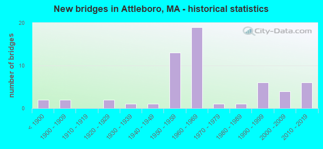
- New bridges - historical statistics
- 2Before 1900
- 21900-1909
- 21920-1929
- 11930-1939
- 11940-1949
- 131950-1959
- 191960-1969
- 11970-1979
- 11980-1989
- 61990-1999
- 42000-2009
- 62010-2019
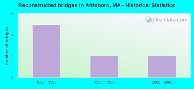
- Reconstructed bridges - Historical Statistics
- 51980-1989
- 21990-1999
- 22000-2009
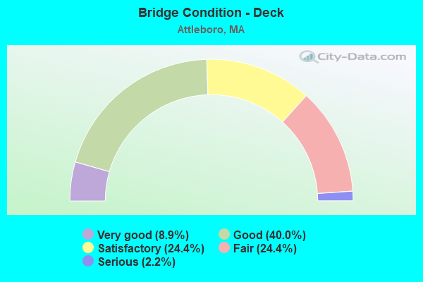
- Bridge Condition - Deck
- 8.9%Very good
- 40.0%Good
- 24.4%Satisfactory
- 24.4%Fair
- 2.2%Serious
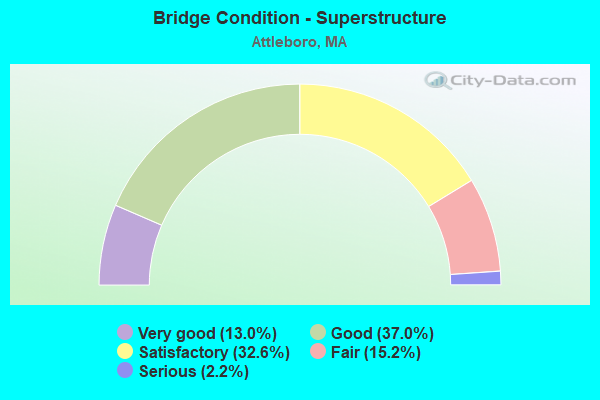
- Bridge Condition - Superstructure
- 13.0%Very good
- 37.0%Good
- 32.6%Satisfactory
- 15.2%Fair
- 2.2%Serious
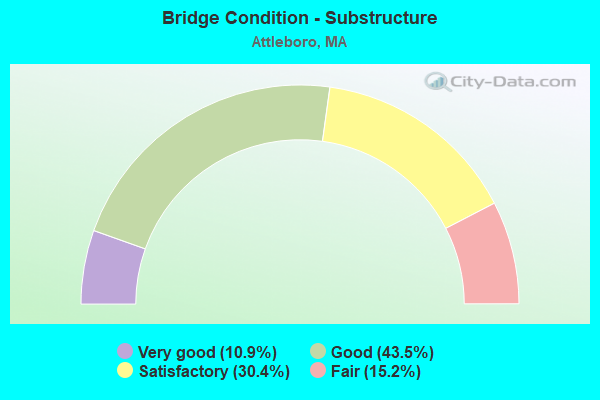
- Bridge Condition - Substructure
- 10.9%Very good
- 43.5%Good
- 30.4%Satisfactory
- 15.2%Fair
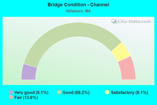
- Bridge Condition - Channel
- 9.1%Very good
- 68.2%Good
- 9.1%Satisfactory
- 13.6%Fair
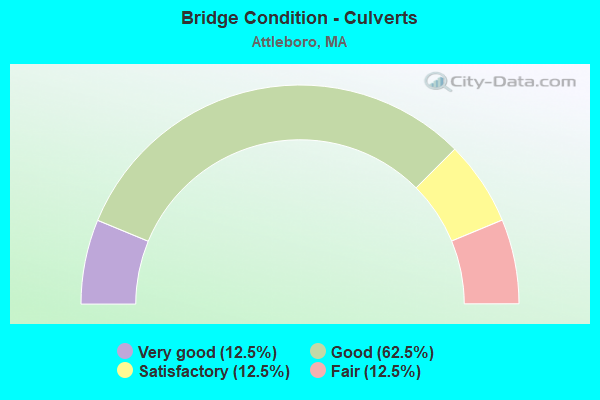
- Bridge Condition - Culverts
- 12.5%Very good
- 62.5%Good
- 12.5%Satisfactory
- 12.5%Fair
Find on map >> Show street view
Structure Number: 53270-00051, Location: GREENWOOD LAKE DAM (Lat: 41.993167, Lng: -71.282667), Route carried "on" structure: Federal lands road , Year Built: 1993, Status: Open, Structure Length: 1.04m (3.41ft), Average Daily Traffic: 30 (year 2021), Average Future Daily Traffic: 50 (year 2041), Features Intersected: G. LAKE DAM SPILLWAY, Facility Carried by Structure: G. LAKE DAM ROAD
Minimum Vertical Clearance: 30.48m (100.00ft), Kilometerpoint: 0.644, Lanes on structure: 1, Owner: Bureau of Fish and Wildlife, Approaching Roadway Width: 4.3m (14.1ft), Material/Design: Concrete, Design/Construction: Culvert, Number Of Spans In Main Unit: 3, Length of Maximum Span: 3.4m (11.2ft), Curb-To-Curb Width: 4.3m (14.1ft), Out-to-Out Width: 7.9m (25.9ft)
Condition: Channel: Good, Culverts: Good, Operating Rating: 36.3 metric tons, Method Used To Determine Operating Rating: Field evaluation and documented engineering judgment, Inventory Rating: 32.7 metric tons, Method Used To Determine Inventory Rating: Field evaluation and documented engineering judgment, Structural Evaluation: Better than present minimum criteria, Deck Geometry: Equal to present minimum criteria, Waterway Adequacy: Better than present minimum criteria, Approach Roadway Alignment: Better than present minimum criteria, Designated Inspection Frequency: Every 24 months, Inspection Date: July 2021
Find on map >> Show street view
Structure Number: A160013UXDOTNBI, Location: AT SEVEN MILE RIVER (Lat: 41.930142, Lng: -71.337017), Route carried "on" structure: State highway 123, Year Built: 1967, Status: Open, Structure Length: 0.82m (2.69ft), Average Daily Traffic: 17,100 (year 2019), Truck Traffic: 6%, Average Future Daily Traffic: 38,377 (year 2031), Design Load: H 20, Features Intersected: WATER SEVEN MILE RIVER
Minimum Vertical Clearance: 30+ m (98+ ft), Kilometerpoint: 41.842, Lanes on structure: 2, Base Highway Network: Yes, Owner: State Highway Agency, Approaching Roadway Width: 13.4m (44.0ft), Material/Design: Prestressed concrete, Design/Construction: Slab, Number Of Spans In Main Unit: 1, Length of Maximum Span: 7.6m (24.9ft), Curb or Sidewalk Widths: Left: 0.8m (2.6ft), Right: 1.9m (6.2ft), Curb-To-Curb Width: 13.4m (44.0ft), Out-to-Out Width: 16.2m (53.1ft)
Condition: Deck: Good, Superstructure: Good, Substructure: Good, Channel: Good, Operating Rating: 74.0 metric tons, Method Used To Determine Operating Rating: Load Factor (LF), Inventory Rating: 60.1 metric tons, Method Used To Determine Inventory Rating: Load Factor (LF), Structural Evaluation: Better than present minimum criteria, Deck Geometry: Equal to present minimum criteria, Waterway Adequacy: Equal to present desirable criteria, Approach Roadway Alignment: Equal to present desirable criteria, Length Of Structure Improvement: 0.90m (2.95ft), Designated Inspection Frequency: Every 24 months, Underwater Inspection Frequency: Every 36 months, Inspection Date: July 2020, Underwater Inspection Date: March 2021, Bridge Improvement Cost: $29,000, Roadway Improvement Cost: $3,000, Total Project Cost: $44,000 ( Estimate for 2022), Deck Structure Type: Concrete Precast Panels, Wearing Surface/Protective System: Wearing Surface: Bituminous, Membrane: Built-up
Find on map >> Show street view
Structure Number: A160033L1MUNNBI, Location: .5 MI SW OF READ ST (Lat: 41.901142, Lng: -71.343453), Route carried "on" structure: City street , Year Built: 1950, Year Reconstructed: 2006, Status: Open, Structure Length: 0.66m (2.17ft), Average Daily Traffic: 8,100 (year 2019), Truck Traffic: 7%, Average Future Daily Traffic: 16,109 (year 2031), Design Load: HS 20, Features Intersected: WATER SEVEN MILE RIVER, Facility Carried by Structure: HWY COUNTY ST
Minimum Vertical Clearance: 30+ m (98+ ft), Kilometerpoint: 0.644, Lanes on structure: 2, Owner: City or Municipal Highway Agency, Approaching Roadway Width: 12.2m (40.0ft), Skew: 3 degrees, Material/Design: Concrete, Design/Construction: Culvert, Number Of Spans In Main Unit: 1, Length of Maximum Span: 5.7m (18.7ft), Curb or Sidewalk Widths: Left: 0.0m, Right: 1.8m (5.9ft)
Condition: Channel: Good, Culverts: Very good, Inventory Rating: 62.3 metric tons, Method Used To Determine Inventory Rating: Load Factor (LF), Structural Evaluation: Equal to present desirable criteria, Waterway Adequacy: Equal to present desirable criteria, Approach Roadway Alignment: Equal to present desirable criteria, Length Of Structure Improvement: 0.20m (0.66ft), Designated Inspection Frequency: Every 24 months, Inspection Date: July 2020, Bridge Improvement Cost: $108,000, Roadway Improvement Cost: $11,000, Total Project Cost: $163,000 ( Estimate for 2022)
Find on map >> Show street view
Structure Number: A16005AWFMUNNBI, Location: .2 M FROM JCT N MAIN ST (Lat: 41.951922, Lng: -71.296686), Route carried "on" structure: City street , Year Built: 1999, Status: Open, Structure Length: 1.35m (4.43ft), Average Daily Traffic: 7,113 (year 2019), Truck Traffic: 4%, Average Future Daily Traffic: 26,769 (year 2032), Design Load: HS 20, Features Intersected: WATER TEN MILE RIVER, Facility Carried by Structure: HWY WEST ST
Minimum Vertical Clearance: 30+ m (98+ ft), Kilometerpoint: 1.384, Lanes on structure: 2, Owner: City or Municipal Highway Agency, Approaching Roadway Width: 8.5m (27.9ft), Material/Design: Prestressed concrete, Design/Construction: Slab, Number Of Spans In Main Unit: 1, Length of Maximum Span: 11.7m (38.4ft), Curb or Sidewalk Widths: Left: 1.5m (4.9ft), Right: 1.5m (4.9ft), Curb-To-Curb Width: 8.5m (27.9ft), Out-to-Out Width: 12.3m (40.4ft)
Condition: Deck: Good, Superstructure: Good, Substructure: Good, Channel: Good, Operating Rating: 58.0 metric tons, Method Used To Determine Operating Rating: Load Factor (LF), Inventory Rating: 34.7 metric tons, Method Used To Determine Inventory Rating: Load Factor (LF), Structural Evaluation: Better than present minimum criteria, Deck Geometry: High priority of replacement, Waterway Adequacy: Equal to present desirable criteria, Approach Roadway Alignment: Equal to present minimum criteria, Length Of Structure Improvement: 1.40m (4.59ft), Designated Inspection Frequency: Every 24 months, Inspection Date: August 2021, Bridge Improvement Cost: $647,000, Roadway Improvement Cost: $65,000, Total Project Cost: $971,000 ( Estimate for 2022), Deck Structure Type: Concrete Precast Panels, Wearing Surface/Protective System: Wearing Surface: Bituminous, Membrane: Preformed Fabric
Find on map >> Show street view
Structure Number: A160068PEMUNNBI, Location: 0.1 KM FROM WEST ST. (Lat: 41.950631, Lng: -71.295781), Route carried "on" structure: City street , Year Built: 2002, Status: Open, Structure Length: 1.20m (3.94ft), Average Daily Traffic: 2,500 (year 2021), Truck Traffic: 5%, Average Future Daily Traffic: 21,163 (year 2032), Design Load: HS 20, Features Intersected: WATER TEN MILE RIVER, Facility Carried by Structure: HWY WATER ST
Minimum Vertical Clearance: 30+ m (98+ ft), Kilometerpoint: 0.100, Lanes on structure: 2, Owner: City or Municipal Highway Agency, Approaching Roadway Width: 9.1m (29.9ft), Material/Design: Prestressed concrete, Design/Construction: Slab, Number Of Spans In Main Unit: 1, Length of Maximum Span: 11.0m (36.1ft), Curb or Sidewalk Widths: Left: 1.9m (6.2ft), Right: 1.9m (6.2ft), Curb-To-Curb Width: 9.1m (29.9ft), Out-to-Out Width: 13.6m (44.6ft)
Condition: Deck: Very good, Superstructure: Very good, Substructure: Very good, Channel: Very good, Operating Rating: 86.2 metric tons, Method Used To Determine Operating Rating: Load Factor (LF), Inventory Rating: 51.5 metric tons, Method Used To Determine Inventory Rating: Load Factor (LF), Structural Evaluation: Equal to present desirable criteria, Deck Geometry: Meets minimum limits, Waterway Adequacy: Equal to present desirable criteria, Approach Roadway Alignment: Equal to present desirable criteria, Length Of Structure Improvement: 1.30m (4.27ft), Designated Inspection Frequency: Every 24 months, Inspection Date: April 2021, Bridge Improvement Cost: $528,000, Roadway Improvement Cost: $53,000, Total Project Cost: $793,000 ( Estimate for 2022), Deck Structure Type: Concrete Precast Panels, Wearing Surface/Protective System: Wearing Surface: Bituminous, Membrane: Built-up, Deck Protection: Internally Sealed
Find on map >> Show street view
Structure Number: A160083L3MUNNBI, Location: .2 MI NW OF RTE 123 (Lat: 41.944883, Lng: -71.288314), Route carried "on" structure: City street , Year Built: 1995, Status: Open, Structure Length: 0.95m (3.12ft), Average Daily Traffic: 1,940 (year 2021), Truck Traffic: 6%, Average Future Daily Traffic: 7,896 (year 2032), Design Load: HS 20, Features Intersected: WATER TEN MILE RIVER, Facility Carried by Structure: HWY HODGES ST
Minimum Vertical Clearance: 30+ m (98+ ft), Kilometerpoint: 0.209, Lanes on structure: 2, Owner: City or Municipal Highway Agency, Approaching Roadway Width: 11.0m (36.1ft), Skew: 2 degrees, Material/Design: Concrete, Design/Construction: Culvert, Number Of Spans In Main Unit: 2, Length of Maximum Span: 4.0m (13.1ft), Curb or Sidewalk Widths: Left: 1.5m (4.9ft), Right: 1.5m (4.9ft), Curb-To-Curb Width: 11.0m (36.1ft), Out-to-Out Width: 17.7m (58.1ft)
Condition: Channel: Fair, Culverts: Fair, Operating Rating: 88.6 metric tons, Method Used To Determine Operating Rating: Load Factor (LF), Inventory Rating: 53.0 metric tons, Method Used To Determine Inventory Rating: Load Factor (LF), Structural Evaluation: Somewhat better than minimum adequacy, Deck Geometry: Equal to present minimum criteria, Waterway Adequacy: Equal to present desirable criteria, Approach Roadway Alignment: Equal to present desirable criteria, Length Of Structure Improvement: 1.30m (4.27ft), Designated Inspection Frequency: Every 24 months, Underwater Inspection Frequency: Every 36 months, Inspection Date: September 2021, Underwater Inspection Date: March 2021, Bridge Improvement Cost: $444,000, Roadway Improvement Cost: $45,000, Total Project Cost: $667,000 ( Estimate for 2022)
Find on map >> Show street view
Structure Number: A160093UYDOTNBI, Location: IN ATTL. CENTER (Lat: 41.943744, Lng: -71.285178), Route carried "on" structure: State highway 123, Year Built: 1967, Status: Open, Structure Length: 0.82m (2.69ft), Average Daily Traffic: 13,100 (year 2018), Truck Traffic: 5%, Average Future Daily Traffic: 27,638 (year 2032), Design Load: H 20, Features Intersected: WATER TEN MILE RIVER
Minimum Vertical Clearance: 30+ m (98+ ft), Kilometerpoint: 9.012, Lanes on structure: 2, Base Highway Network: Yes, Owner: State Highway Agency, Approaching Roadway Width: 10.7m (35.1ft), Material/Design: Prestressed concrete, Design/Construction: Slab, Number Of Spans In Main Unit: 1, Length of Maximum Span: 7.3m (24.0ft), Curb or Sidewalk Widths: Left: 2.3m (7.5ft), Right: 2.0m (6.6ft), Curb-To-Curb Width: 10.8m (35.4ft), Out-to-Out Width: 15.1m (49.5ft)
Condition: Deck: Fair, Superstructure: Fair, Substructure: Good, Channel: Good, Operating Rating: 59.6 metric tons, Method Used To Determine Operating Rating: Load Factor (LF), Inventory Rating: 49.6 metric tons, Method Used To Determine Inventory Rating: Load Factor (LF), Structural Evaluation: Somewhat better than minimum adequacy, Deck Geometry: Meets minimum limits, Waterway Adequacy: Equal to present desirable criteria, Approach Roadway Alignment: Equal to present desirable criteria, Length Of Structure Improvement: 0.90m (2.95ft), Designated Inspection Frequency: Every 24 months, Underwater Inspection Frequency: Every 36 months, Inspection Date: July 2021, Underwater Inspection Date: September 2020, Bridge Improvement Cost: $534,000, Roadway Improvement Cost: $54,000, Total Project Cost: $802,000 ( Estimate for 2022), Deck Structure Type: Concrete Precast Panels, Wearing Surface/Protective System: Wearing Surface: Bituminous, Membrane: Built-up, Deck Protection: Internally Sealed
Find on map >> Show street view
Structure Number: A160103L4MUNNBI, Location: .1 MI W OF RTE 123 (Lat: 41.942136, Lng: -71.286400), Route carried "on" structure: City street , Year Built: 1976, Status: Open, Structure Length: 2.11m (6.92ft), Average Daily Traffic: 3,800 (year 2021), Truck Traffic: 16%, Average Future Daily Traffic: 12,319 (year 2032), Design Load: H 20, Features Intersected: WATER TEN MILE RIVER, Facility Carried by Structure: HWY WALL ST
Minimum Vertical Clearance: 30+ m (98+ ft), Kilometerpoint: 0.048, Lanes on structure: 2, Owner: City or Municipal Highway Agency, Approaching Roadway Width: 9.1m (29.9ft), Skew: 4 degrees, Material/Design: Steel, Design/Construction: Stringer/Multi-beam, Number Of Spans In Main Unit: 1, Length of Maximum Span: 19.5m (64.0ft), Curb or Sidewalk Widths: Left: 1.5m (4.9ft), Right: 1.5m (4.9ft), Curb-To-Curb Width: 9.1m (29.9ft), Out-to-Out Width: 13.4m (44.0ft)
Condition: Deck: Satisfactory, Superstructure: Good, Substructure: Good, Channel: Good, Operating Rating: 45.7 metric tons, Method Used To Determine Operating Rating: Load Factor (LF), Inventory Rating: 27.4 metric tons, Method Used To Determine Inventory Rating: Load Factor (LF), Structural Evaluation: Equal to present minimum criteria, Deck Geometry: Meets minimum limits, Waterway Adequacy: Better than present minimum criteria, Approach Roadway Alignment: Equal to present minimum criteria, Length Of Structure Improvement: 2.20m (7.22ft), Designated Inspection Frequency: Every 24 months, Inspection Date: April 2021, Bridge Improvement Cost: $1,158,000, Roadway Improvement Cost: $116,000, Total Project Cost: $1,738,000 ( Estimate for 2022), Deck Structure Type: Concrete Cast-file-Place, Wearing Surface/Protective System: Wearing Surface: Bituminous, Membrane: Built-up
Find on map >> Show street view
Structure Number: A160113HVMUNNBI, Location: .1 MI SO OF ST 123 (Lat: 41.937417, Lng: -71.290239), Route carried "on" structure: City street , Year Built: 1920, Year Reconstructed: 1986, Status: Open, Structure Length: 1.19m (3.90ft), Average Daily Traffic: 8,922 (year 2022), Truck Traffic: 6%, Average Future Daily Traffic: 30,165 (year 2033), Design Load: H 20, Features Intersected: WATER TEN MILE RIVER, Facility Carried by Structure: HWY OLIVE ST
Minimum Vertical Clearance: 30+ m (98+ ft), Kilometerpoint: 0.161, Lanes on structure: 2, Owner: City or Municipal Highway Agency, Approaching Roadway Width: 7.9m (25.9ft), Material/Design: Prestressed concrete, Design/Construction: Slab, Number Of Spans In Main Unit: 1, Length of Maximum Span: 11.6m (38.1ft), Curb or Sidewalk Widths: Left: 1.7m (5.6ft), Right: 1.7m (5.6ft), Curb-To-Curb Width: 7.9m (25.9ft), Out-to-Out Width: 11.9m (39.0ft)
Condition: Deck: Fair, Superstructure: Fair, Substructure: Good, Channel: Good, Operating Rating: 48.8 metric tons, Method Used To Determine Operating Rating: Load Factor (LF), Inventory Rating: 39.8 metric tons, Method Used To Determine Inventory Rating: Load Factor (LF), Structural Evaluation: Somewhat better than minimum adequacy, Deck Geometry: High priority of replacement, Waterway Adequacy: Equal to present desirable criteria, Approach Roadway Alignment: Equal to present desirable criteria, Length Of Structure Improvement: 1.20m (3.94ft), Designated Inspection Frequency: Every 24 months, Inspection Date: Febuary 2022, Bridge Improvement Cost: $561,000, Roadway Improvement Cost: $57,000, Total Project Cost: $842,000 ( Estimate for 2022), Deck Structure Type: Concrete Precast Panels, Wearing Surface/Protective System: Wearing Surface: Bituminous, Membrane: Built-up
Find on map >> Show street view
Structure Number: A160123L2MUNNBI, Location: 1.8MI E OF RT.95 (Lat: 41.933058, Lng: -71.287869), Route carried "on" structure: City street , Year Built: 1905, Year Reconstructed: 1993, Status: Open, Structure Length: 1.22m (4.00ft), Average Daily Traffic: 4,914 (year 2022), Truck Traffic: 5%, Average Future Daily Traffic: 21,478 (year 2033), Design Load: HS 20, Features Intersected: WATER TEN MILE RIVER, Facility Carried by Structure: HWY LAMB ST
Minimum Vertical Clearance: 30+ m (98+ ft), Kilometerpoint: 0.386, Lanes on structure: 2, Owner: City or Municipal Highway Agency, Approaching Roadway Width: 7.9m (25.9ft), Material/Design: Prestressed concrete, Design/Construction: Slab, Number Of Spans In Main Unit: 1, Length of Maximum Span: 10.4m (34.1ft), Curb or Sidewalk Widths: Left: 2.1m (6.9ft), Right: 2.1m (6.9ft), Curb-To-Curb Width: 7.9m (25.9ft), Out-to-Out Width: 12.1m (39.7ft)
Condition: Deck: Good, Superstructure: Good, Substructure: Satisfactory, Channel: Fair, Operating Rating: 82.9 metric tons, Method Used To Determine Operating Rating: Load Factor (LF), Inventory Rating: 49.6 metric tons, Method Used To Determine Inventory Rating: Load Factor (LF), Structural Evaluation: Equal to present minimum criteria, Deck Geometry: High priority of corrective action, Waterway Adequacy: Better than present minimum criteria, Approach Roadway Alignment: Meets minimum limits, Length Of Structure Improvement: 1.30m (4.27ft), Designated Inspection Frequency: Every 24 months, Underwater Inspection Frequency: Every 36 months, Inspection Date: Febuary 2022, Underwater Inspection Date: November 2020, Bridge Improvement Cost: $675,000, Roadway Improvement Cost: $68,000, Total Project Cost: $1,013,000 ( Estimate for 2022), Deck Structure Type: Concrete Precast Panels, Wearing Surface/Protective System: Wearing Surface: Bituminous, Membrane: Built-up
Find on map >> Show street view
Structure Number: A160133HWMUNNBI, Location: .1 MI N OF RTE 152 (Lat: 41.927625, Lng: -71.289286), Route carried "on" structure: City street , Year Built: 1994, Status: Open, Structure Length: 0.79m (2.59ft), Average Daily Traffic: 6,600 (year 2021), Truck Traffic: 16%, Average Future Daily Traffic: 7,896 (year 2032), Design Load: HS 20, Features Intersected: WATER TEN MILE RIVER, Facility Carried by Structure: HWY THACHER ST
Minimum Vertical Clearance: 30+ m (98+ ft), Kilometerpoint: 0.306, Lanes on structure: 2, Owner: City or Municipal Highway Agency, Approaching Roadway Width: 8.5m (27.9ft), Material/Design: Concrete, Design/Construction: Culvert, Number Of Spans In Main Unit: 2, Length of Maximum Span: 3.7m (12.1ft), Curb or Sidewalk Widths: Left: 1.6m (5.2ft), Right: 0.3m (1.0ft), Curb-To-Curb Width: 8.6m (28.2ft), Out-to-Out Width: 12.2m (40.0ft)
Condition: Channel: Satisfactory, Culverts: Satisfactory, Operating Rating: 90.2 metric tons, Method Used To Determine Operating Rating: Load Factor (LF), Inventory Rating: 54.0 metric tons, Method Used To Determine Inventory Rating: Load Factor (LF), Structural Evaluation: Equal to present minimum criteria, Deck Geometry: High priority of replacement, Waterway Adequacy: Equal to present desirable criteria, Approach Roadway Alignment: Equal to present desirable criteria, Length Of Structure Improvement: 0.50m (1.64ft), Designated Inspection Frequency: Every 24 months, Underwater Inspection Frequency: Every 36 months, Inspection Date: September 2021, Underwater Inspection Date: March 2021, Bridge Improvement Cost: $373,000, Roadway Improvement Cost: $38,000, Total Project Cost: $560,000 ( Estimate for 2022)
Find on map >> Show street view
Structure Number: A16014B0VMUNNBI, Location: BETWEEN COUNTY&S. MAIN ST (Lat: 41.917811, Lng: -71.305794), Route carried "on" structure: City street , Year Built: 2004, Status: Open, Structure Length: 0.64m (2.10ft), Average Daily Traffic: 6,724 (year 2016), Truck Traffic: 6%, Average Future Daily Traffic: 12,476 (year 2031), Design Load: HS 20, Features Intersected: WATER TEN MILE RIVER, Facility Carried by Structure: HWY TIFFANY ST
Minimum Vertical Clearance: 30+ m (98+ ft), Kilometerpoint: 0.000, Lanes on structure: 2, Owner: City or Municipal Highway Agency, Approaching Roadway Width: 9.7m (31.8ft), Material/Design: Concrete, Design/Construction: Culvert, Number Of Spans In Main Unit: 2, Length of Maximum Span: 3.4m (11.2ft), Curb or Sidewalk Widths: Left: 0.0m, Right: 1.5m (4.9ft), Curb-To-Curb Width: 7.1m (23.3ft), Out-to-Out Width: 9.7m (31.8ft)
Condition: Channel: Good, Culverts: Good, Operating Rating: 56.5 metric tons, Method Used To Determine Operating Rating: Load Factor (LF), Inventory Rating: 33.8 metric tons, Method Used To Determine Inventory Rating: Load Factor (LF), Structural Evaluation: Better than present minimum criteria, Deck Geometry: High priority of replacement, Waterway Adequacy: Equal to present desirable criteria, Approach Roadway Alignment: Equal to present desirable criteria, Length Of Structure Improvement: 0.70m (2.30ft), Designated Inspection Frequency: Every 24 months, Inspection Date: August 2020, Bridge Improvement Cost: $423,000, Roadway Improvement Cost: $43,000, Total Project Cost: $635,000 ( Estimate for 2022)
Find on map >> Show street view
Structure Number: A160153L0MUNNBI, Location: 100 FT W OF KNIGHT ST (Lat: 41.905169, Lng: -71.319553), Route carried "on" structure: City street , Year Built: 1850, Year Reconstructed: 2006, Status: Open, Structure Length: 0.94m (3.08ft), Average Daily Traffic: 4,150 (year 2018), Truck Traffic: 6%, Average Future Daily Traffic: 4,738 (year 2031), Features Intersected: WATER TEN MILE RIVER, Facility Carried by Structure: HWY BRIDGE ST
Minimum Vertical Clearance: 30+ m (98+ ft), Kilometerpoint: 0.097, Lanes on structure: 2, Owner: City or Municipal Highway Agency, Approaching Roadway Width: 5.8m (19.0ft), Material/Design: Masonry, Design/Construction: Arch - Deck, Number Of Spans In Main Unit: 1, Length of Maximum Span: 9.4m (30.8ft), Curb or Sidewalk Widths: Left: 1.5m (4.9ft), Right: 0.0m, Curb-To-Curb Width: 7.4m (24.3ft), Out-to-Out Width: 9.9m (32.5ft)
Condition: Superstructure: Satisfactory, Substructure: Satisfactory, Channel: Good, Operating Rating: 75.8 metric tons, Method Used To Determine Operating Rating: Allowable Stress (AS), Inventory Rating: 44.0 metric tons, Method Used To Determine Inventory Rating: Allowable Stress (AS), Structural Evaluation: Equal to present minimum criteria, Deck Geometry: High priority of replacement, Waterway Adequacy: Equal to present minimum criteria, Approach Roadway Alignment: Equal to present minimum criteria, Length Of Structure Improvement: 1.00m (3.28ft), Designated Inspection Frequency: Every 24 months, Underwater Inspection Frequency: Every 36 months, Inspection Date: November 2020, Underwater Inspection Date: June 2020, Bridge Improvement Cost: $566,000, Roadway Improvement Cost: $57,000, Total Project Cost: $850,000 ( Estimate for 2022)
Find on map >> Show street view
Structure Number: A16018945MUNNBI, Location: @ COLONAL BLAKINGTON INN (Lat: 41.949956, Lng: -71.290042), Route carried "on" structure: City street 152, Year Built: 2012, Status: Open, Structure Length: 1.00m (3.28ft), Average Daily Traffic: 11,598 (year 2017), Truck Traffic: 6%, Average Future Daily Traffic: 28,427 (year 2005), Design Load: HS 25 or greater, Features Intersected: WATER BUNGAY RIVER
Minimum Vertical Clearance: 30+ m (98+ ft), Kilometerpoint: 7.129, Lanes on structure: 2, Base Highway Network: Yes, Owner: Town or Township Highway Agency, Approaching Roadway Width: 10.3m (33.8ft), Skew: 2 degrees, Material/Design: Steel, Design/Construction: Stringer/Multi-beam, Number Of Spans In Main Unit: 1, Length of Maximum Span: 9.9m (32.5ft), Curb or Sidewalk Widths: Left: 1.9m (6.2ft), Right: 1.8m (5.9ft), Curb-To-Curb Width: 10.4m (34.1ft), Out-to-Out Width: 14.7m (48.2ft)
Condition: Deck: Very good, Superstructure: Very good, Substructure: Very good, Channel: Very good, Inventory Rating: 63.9 metric tons, Method Used To Determine Inventory Rating: Load Factor (LF), Structural Evaluation: Equal to present desirable criteria, Deck Geometry: Meets minimum limits, Waterway Adequacy: Meets minimum limits, Approach Roadway Alignment: Equal to present minimum criteria, Length Of Structure Improvement: 1.00m (3.28ft), Designated Inspection Frequency: Every 24 months, Inspection Date: August 2020, Bridge Improvement Cost: $287,000, Roadway Improvement Cost: $29,000, Total Project Cost: $431,000 ( Estimate for 2022), Deck Structure Type: Concrete Cast-file-Place, Wearing Surface/Protective System: Wearing Surface: Bituminous, Membrane: Preformed Fabric, Deck Protection: Epoxy Coated Reinforcing
Find on map >> Show street view
Structure Number: A16019400DOT634, Location: RR MP 198.68 (Lat: 41.961792, Lng: -71.270128), Route carried "on" structure: City street , Year Built: 1987, Status: Open, Structure Length: 2.71m (8.89ft), Average Daily Traffic: 3,464 (year 2017), Truck Traffic: 6%, Average Future Daily Traffic: 8,686 (year 2031), Design Load: HS 20+Mod, Features Intersected: RR AMTRAK/MBTA, Facility Carried by Structure: HWY LINDSEY ST
Minimum Vertical Clearance: 30+ m (98+ ft), Kilometerpoint: 0.966, Lanes on structure: 2, Owner: State Highway Agency, Approaching Roadway Width: 12.2m (40.0ft), Skew: 5 degrees, Material/Design: Steel, Design/Construction: Stringer/Multi-beam, Number Of Spans In Main Unit: 1, Length of Maximum Span: 25.2m (82.7ft), Curb or Sidewalk Widths: Left: 1.9m (6.2ft), Right: 0.6m (2.0ft), Curb-To-Curb Width: 12.2m (40.0ft), Out-to-Out Width: 14.7m (48.2ft)
Condition: Deck: Good, Superstructure: Good, Substructure: Good, Operating Rating: 55.7 metric tons, Method Used To Determine Operating Rating: Load Factor (LF), Inventory Rating: 34.7 metric tons, Method Used To Determine Inventory Rating: Load Factor (LF), Structural Evaluation: Better than present minimum criteria, Deck Geometry: Equal to present minimum criteria, Underclear: High priority of corrective action, Approach Roadway Alignment: Equal to present desirable criteria, Length Of Structure Improvement: 2.80m (9.19ft), Designated Inspection Frequency: Every 24 months, Inspection Date: July 2020, Bridge Improvement Cost: $317,000, Roadway Improvement Cost: $32,000, Total Project Cost: $476,000 ( Estimate for 2022), Deck Structure Type: Concrete Cast-file-Place, Wearing Surface/Protective System: Wearing Surface: Bituminous, Membrane: Built-up, Deck Protection: Epoxy Coated Reinforcing
Find on map >> Show street view
Structure Number: A160203YYDOT634, Location: .2MI.N OF ST 123 (Lat: 41.952800, Lng: -71.276511), Route carried "on" structure: City street , Year Built: 1962, Status: Open, Structure Length: 3.17m (10.40ft), Average Daily Traffic: 14,400 (year 2016), Truck Traffic: 4%, Average Future Daily Traffic: 40,430 (year 2032), Design Load: H 20, Features Intersected: RR AMTRAK/MBTA, Facility Carried by Structure: HWY HOLDEN ST
Minimum Vertical Clearance: 30+ m (98+ ft), Kilometerpoint: 0.000, Lanes on structure: 2, Owner: State Highway Agency, Approaching Roadway Width: 12.2m (40.0ft), Material/Design: Steel, Design/Construction: Stringer/Multi-beam, Number Of Spans In Main Unit: 1, Number Of Approach Spans: 2, Length of Maximum Span: 18.1m (59.4ft), Curb or Sidewalk Widths: Left: 1.6m (5.2ft), Right: 1.6m (5.2ft), Curb-To-Curb Width: 12.2m (40.0ft), Out-to-Out Width: 16.2m (53.1ft)
Condition: Deck: Satisfactory, Superstructure: Satisfactory, Substructure: Satisfactory, Operating Rating: 48.1 metric tons, Method Used To Determine Operating Rating: Load Factor (LF), Inventory Rating: 28.8 metric tons, Method Used To Determine Inventory Rating: Load Factor (LF), Structural Evaluation: Equal to present minimum criteria, Deck Geometry: Somewhat better than minimum adequacy, Underclear: High priority of corrective action, Approach Roadway Alignment: Equal to present desirable criteria, Length Of Structure Improvement: 3.20m (10.50ft), Designated Inspection Frequency: Every 24 months, Inspection Date: July 2020, Bridge Improvement Cost: $2,037,000, Roadway Improvement Cost: $204,000, Total Project Cost: $3,056,000 ( Estimate for 2022), Deck Structure Type: Concrete Cast-file-Place, Wearing Surface/Protective System: Wearing Surface: Bituminous, Membrane: Built-up
Find on map >> Show street view
Structure Number: A16025AMYDOT634, Location: RR AMTRAK MP 196.72 (Lat: 41.936275, Lng: -71.288181), Route carried "on" structure: City street , Year Built: 2013, Status: Open, Structure Length: 5.06m (16.60ft), Average Daily Traffic: 10,900 (year 2018), Truck Traffic: 6%, Design Load: HS 25 or greater, Features Intersected: RR AMTRAK/MBTA, Facility Carried by Structure: HWY OLIVE ST
Minimum Vertical Clearance: 99.00m (324.80ft), Kilometerpoint: 0.000, Lanes on structure: 2, Owner: State Highway Agency, Approaching Roadway Width: 8.5m (27.9ft), Skew: 1 degrees, Material/Design: Prestressed concrete continuous, Design/Construction: Box Beam or Girders - Single/Spread, Number Of Spans In Main Unit: 3, Length of Maximum Span: 26.5m (86.9ft), Curb or Sidewalk Widths: Left: 1.5m (4.9ft), Right: 1.5m (4.9ft), Curb-To-Curb Width: 8.5m (27.9ft), Out-to-Out Width: 12.3m (40.4ft)
Condition: Deck: Good, Superstructure: Very good, Substructure: Very good, Operating Rating: 97.4 metric tons, Method Used To Determine Operating Rating: Load Factor (LF), Inventory Rating: 74.5 metric tons, Method Used To Determine Inventory Rating: Load Factor (LF), Structural Evaluation: Equal to present desirable criteria, Deck Geometry: High priority of replacement, Underclear: Meets minimum limits, Approach Roadway Alignment: Somewhat better than minimum adequacy, Length Of Structure Improvement: 5.10m (16.73ft), Designated Inspection Frequency: Every 24 months, Inspection Date: October 2020, Bridge Improvement Cost: $2,342,000, Roadway Improvement Cost: $235,000, Total Project Cost: $3,514,000 ( Estimate for 2022), Deck Structure Type: Concrete Cast-file-Place, Wearing Surface/Protective System: Wearing Surface: Bituminous, Membrane: Preformed Fabric, Deck Protection: Epoxy Coated Reinforcing
Find on map >> Show street view
Structure Number: A16026AQPDOT634, Location: RR AMTRAK MP 196.36 (Lat: 41.931750, Lng: -71.291347), Route carried "on" structure: City street , Year Built: 2006, Status: Open, Structure Length: 2.33m (7.64ft), Average Daily Traffic: 13,100 (year 2018), Truck Traffic: 6%, Average Future Daily Traffic: 22,110 (year 2031), Design Load: HS 20, Features Intersected: RR AMTRAK/MBTA, Facility Carried by Structure: HWY THACHER ST
Minimum Vertical Clearance: 30+ m (98+ ft), Kilometerpoint: 0.000, Lanes on structure: 2, Owner: State Highway Agency, Approaching Roadway Width: 9.8m (32.2ft), Skew: 2 degrees, Material/Design: Prestressed concrete, Design/Construction: Box Beam or Girders - Single/Spread, Number Of Spans In Main Unit: 1, Length of Maximum Span: 22.8m (74.8ft), Curb or Sidewalk Widths: Left: 0.0m, Right: 1.5m (4.9ft), Curb-To-Curb Width: 9.8m (32.2ft), Out-to-Out Width: 12.1m (39.7ft)
Condition: Deck: Good, Superstructure: Very good, Substructure: Good, Operating Rating: 61.9 metric tons, Method Used To Determine Operating Rating: Load Factor (LF), Inventory Rating: 43.0 metric tons, Method Used To Determine Inventory Rating: Load Factor (LF), Structural Evaluation: Better than present minimum criteria, Deck Geometry: Meets minimum limits, Underclear: High priority of corrective action, Approach Roadway Alignment: Equal to present desirable criteria, Length Of Structure Improvement: 2.40m (7.87ft), Designated Inspection Frequency: Every 24 months, Inspection Date: October 2020, Bridge Improvement Cost: $815,000, Roadway Improvement Cost: $82,000, Total Project Cost: $1,223,000 ( Estimate for 2022), Deck Structure Type: Concrete Cast-file-Place, Wearing Surface/Protective System: Wearing Surface: Integral Concrete, Membrane: Built-up, Deck Protection: Epoxy Coated Reinforcing
Find on map >> Show street view
Structure Number: A16027401DOT634, Location: 1.5 MI NE OF SEEKONK TL (Lat: 41.917625, Lng: -71.301372), Route carried "on" structure: State highway 152, Year Built: 1949, Status: Open, Structure Length: 7.41m (24.31ft), Average Daily Traffic: 16,163 (year 2018), Truck Traffic: 12%, Average Future Daily Traffic: 22,110 (year 2033), Design Load: H 20, Features Intersected: RR AMTRAK/MBTA
Minimum Vertical Clearance: 30+ m (98+ ft), Kilometerpoint: 9.963, Lanes on structure: 2, Owner: State Highway Agency, Approaching Roadway Width: 12.2m (40.0ft), Skew: 5 degrees, Material/Design: Steel, Design/Construction: Girder and Floorbeam System, Number Of Spans In Main Unit: 3, Length of Maximum Span: 37.5m (123.0ft), Curb or Sidewalk Widths: Left: 2.1m (6.9ft), Right: 2.1m (6.9ft), Curb-To-Curb Width: 12.2m (40.0ft), Out-to-Out Width: 16.5m (54.1ft)
Condition: Deck: Fair, Superstructure: Fair, Substructure: Good, Operating Rating: 53.7 metric tons, Method Used To Determine Operating Rating: Load Factor (LF), Inventory Rating: 32.1 metric tons, Method Used To Determine Inventory Rating: Load Factor (LF), Structural Evaluation: Somewhat better than minimum adequacy, Deck Geometry: Somewhat better than minimum adequacy, Underclear: High priority of corrective action, Approach Roadway Alignment: Better than present minimum criteria, Length Of Structure Improvement: 7.50m (24.61ft), Designated Inspection Frequency: Every 24 months, Critical Feature Inspection Frequency: Every 24 months, Inspection Date: August 2020, Critical Feature Inspection Date: August 2020, Bridge Improvement Cost: $4,861,000, Roadway Improvement Cost: $487,000, Total Project Cost: $7,292,000 ( Estimate for 2022), Deck Structure Type: Concrete Cast-file-Place, Wearing Surface/Protective System: Wearing Surface: Bituminous, Membrane: Built-up
Find on map >> Show street view
Structure Number: A160283YTDOT634, Location: AMTRAK RR MP 194/51 (Lat: 41.912069, Lng: -71.305264), Route carried "on" structure: City street , Year Built: 1990, Status: Open, Structure Length: 2.10m (6.89ft), Average Daily Traffic: 4,345 (year 2018), Truck Traffic: 7%, Average Future Daily Traffic: 5,054 (year 2031), Design Load: HS 20+Mod, Features Intersected: RR AMTRAK/MBTA, Facility Carried by Structure: HWY THURBER AVE
Minimum Vertical Clearance: 30+ m (98+ ft), Kilometerpoint: 0.000, Lanes on structure: 2, Owner: State Highway Agency, Approaching Roadway Width: 8.5m (27.9ft), Material/Design: Prestressed concrete, Design/Construction: Box Beam or Girders - Multiple, Number Of Spans In Main Unit: 1, Length of Maximum Span: 20.1m (65.9ft), Curb or Sidewalk Widths: Left: 1.7m (5.6ft), Right: 0.2m (0.7ft), Curb-To-Curb Width: 8.5m (27.9ft), Out-to-Out Width: 11.3m (37.1ft)
Condition: Deck: Good, Superstructure: Good, Substructure: Good, Operating Rating: 63.3 metric tons, Method Used To Determine Operating Rating: Load Factor (LF), Inventory Rating: 37.9 metric tons, Method Used To Determine Inventory Rating: Load Factor (LF), Structural Evaluation: Better than present minimum criteria, Deck Geometry: Meets minimum limits, Underclear: High priority of corrective action, Approach Roadway Alignment: Equal to present minimum criteria, Length Of Structure Improvement: 2.20m (7.22ft), Designated Inspection Frequency: Every 24 months, Inspection Date: July 2020, Bridge Improvement Cost: $1,017,000, Roadway Improvement Cost: $102,000, Total Project Cost: $1,526,000 ( Estimate for 2022), Deck Structure Type: Concrete Precast Panels, Wearing Surface/Protective System: Wearing Surface: Bituminous, Membrane: Built-up, Deck Protection: Epoxy Coated Reinforcing
Find on map >> Show street view
Structure Number: A160293VMDOTNBI, Location: HEBRONVILLE RR #193.89 (Lat: 41.904364, Lng: -71.317994), Route carried "on" structure: State highway 152, Year Built: 1966, Status: Open, Structure Length: 3.02m (9.91ft), Average Daily Traffic: 12,800 (year 2018), Truck Traffic: 3%, Average Future Daily Traffic: 18,794 (year 2033), Design Load: H 20, Features Intersected: RR AMTRAK/MBTA
Minimum Vertical Clearance: 30+ m (98+ ft), Kilometerpoint: 7.853, Lanes on structure: 2, Owner: State Highway Agency, Approaching Roadway Width: 13.4m (44.0ft), Skew: 4 degrees, Material/Design: Steel, Design/Construction: Stringer/Multi-beam, Number Of Spans In Main Unit: 1, Length of Maximum Span: 29.3m (96.1ft), Curb or Sidewalk Widths: Left: 1.8m (5.9ft), Right: 1.8m (5.9ft), Curb-To-Curb Width: 13.4m (44.0ft), Out-to-Out Width: 17.3m (56.8ft)
Condition: Deck: Good, Superstructure: Satisfactory, Substructure: Satisfactory, Operating Rating: 52.2 metric tons, Method Used To Determine Operating Rating: Allowable Stress (AS), Inventory Rating: 28.8 metric tons, Method Used To Determine Inventory Rating: Allowable Stress (AS), Structural Evaluation: Equal to present minimum criteria, Deck Geometry: Equal to present minimum criteria, Underclear: High priority of corrective action, Approach Roadway Alignment: Equal to present desirable criteria, Length Of Structure Improvement: 3.10m (10.17ft), Designated Inspection Frequency: Every 24 months, Inspection Date: October 2020, Bridge Improvement Cost: $2,107,000, Roadway Improvement Cost: $211,000, Total Project Cost: $3,161,000 ( Estimate for 2022), Deck Structure Type: Concrete Cast-file-Place, Wearing Surface/Protective System: Wearing Surface: Bituminous, Membrane: Built-up
Find on map >> Show street view
Structure Number: A16030403DOT634, Location: AMTRAK RR MM 193.4 (Lat: 41.902189, Lng: -71.330247), Route carried "on" structure: City street , Year Built: 1991, Status: Open, Structure Length: 1.55m (5.09ft), Average Daily Traffic: 5,900 (year 2018), Truck Traffic: 8%, Average Future Daily Traffic: 10,265 (year 2033), Design Load: HS 20+Mod, Features Intersected: RR AMTRAK/MBTA, Facility Carried by Structure: HWY POND ST
Minimum Vertical Clearance: 30+ m (98+ ft), Kilometerpoint: 0.000, Lanes on structure: 2, Owner: State Highway Agency, Approaching Roadway Width: 8.5m (27.9ft), Skew: 1 degrees, Material/Design: Prestressed concrete, Design/Construction: Slab, Number Of Spans In Main Unit: 1, Length of Maximum Span: 15.4m (50.5ft), Curb or Sidewalk Widths: Left: 0.6m (2.0ft), Right: 2.0m (6.6ft), Curb-To-Curb Width: 8.5m (27.9ft), Out-to-Out Width: 11.1m (36.4ft)
Condition: Deck: Fair, Superstructure: Fair, Substructure: Good, Operating Rating: 62.2 metric tons, Method Used To Determine Operating Rating: Load Factor (LF), Inventory Rating: 37.3 metric tons, Method Used To Determine Inventory Rating: Load Factor (LF), Structural Evaluation: Somewhat better than minimum adequacy, Deck Geometry: High priority of replacement, Underclear: High priority of corrective action, Approach Roadway Alignment: Equal to present desirable criteria, Length Of Structure Improvement: 1.60m (5.25ft), Designated Inspection Frequency: Every 24 months, Inspection Date: November 2020, Bridge Improvement Cost: $698,000, Roadway Improvement Cost: $70,000, Total Project Cost: $1,048,000 ( Estimate for 2022), Deck Structure Type: Concrete Precast Panels, Wearing Surface/Protective System: Wearing Surface: Bituminous, Membrane: Built-up, Deck Protection: Epoxy Coated Reinforcing
Find on map >> Show street view
Structure Number: A16031AP8DOT634, Location: AMTRAK MM 192.47 (Lat: 41.899444, Lng: -71.345694), Route carried "on" structure: City street , Year Built: 2011, Status: Open, Structure Length: 3.40m (11.15ft), Average Daily Traffic: 14,300 (year 2018), Truck Traffic: 5%, Average Future Daily Traffic: 15,477 (year 2032), Design Load: HS 20, Features Intersected: RR AMTRAK/MBTA, Facility Carried by Structure: HWY COUNTY ST
Minimum Vertical Clearance: 30+ m (98+ ft), Kilometerpoint: 0.322, Lanes on structure: 2, Owner: State Highway Agency, Approaching Roadway Width: 12.2m (40.0ft), Skew: 5 degrees, Material/Design: Steel continuous, Design/Construction: Stringer/Multi-beam, Number Of Spans In Main Unit: 3, Length of Maximum Span: 15.7m (51.5ft), Curb or Sidewalk Widths: Left: 1.5m (4.9ft), Right: 0.0m, Curb-To-Curb Width: 12.2m (40.0ft), Out-to-Out Width: 14.5m (47.6ft)
Condition: Deck: Good, Superstructure: Good, Substructure: Good, Operating Rating: 87.1 metric tons, Method Used To Determine Operating Rating: Load Factor (LF), Inventory Rating: 52.1 metric tons, Method Used To Determine Inventory Rating: Load Factor (LF), Structural Evaluation: Better than present minimum criteria, Deck Geometry: Somewhat better than minimum adequacy, Underclear: Meets minimum limits, Approach Roadway Alignment: Equal to present desirable criteria, Length Of Structure Improvement: 3.50m (11.48ft), Designated Inspection Frequency: Every 24 months, Inspection Date: October 2020, Bridge Improvement Cost: $396,000, Roadway Improvement Cost: $40,000, Total Project Cost: $595,000 ( Estimate for 2022), Deck Structure Type: Concrete Cast-file-Place, Wearing Surface/Protective System: Wearing Surface: Bituminous, Membrane: Preformed Fabric, Deck Protection: Epoxy Coated Reinforcing
Find on map >> Show street view
Structure Number: A16032B59DOT634, Location: .2 MI SO I 95 INTERCHANGE (Lat: 41.897892, Lng: -71.354794), Route carried "on" structure: Alternate State highway 1A, Year Built: 2011, Status: Open, Structure Length: 2.84m (9.32ft), Average Daily Traffic: 33,100 (year 2019), Truck Traffic: 4%, Average Future Daily Traffic: 51,643 (year 2032), Design Load: HS 25 or greater, Features Intersected: COMB RR AMTRAK/MBTA RD, Facility Carried by Structure: ST 1 A/NEWPRT AV
Minimum Vertical Clearance: 30+ m (98+ ft), Kilometerpoint: 0.080, Lanes on structure: 5, Lanes under structure: 2, Base Highway Network: Yes, Owner: State Highway Agency, Approaching Roadway Width: 23.0m (75.5ft), Material/Design: Steel, Design/Construction: Stringer/Multi-beam, Number Of Spans In Main Unit: 1, Length of Maximum Span: 27.4m (89.9ft), Curb or Sidewalk Widths: Left: 1.5m (4.9ft), Right: 1.5m (4.9ft), Curb-To-Curb Width: 21.9m (71.9ft), Out-to-Out Width: 21.9m (71.9ft)
Condition: Deck: Good, Superstructure: Good, Substructure: Good, Operating Rating: 68.9 metric tons, Method Used To Determine Operating Rating: Load Factor (LF), Inventory Rating: 46.6 metric tons, Method Used To Determine Inventory Rating: Load Factor (LF), Structural Evaluation: Better than present minimum criteria, Deck Geometry: Somewhat better than minimum adequacy, Underclear: High priority of corrective action, Approach Roadway Alignment: Equal to present desirable criteria, Length Of Structure Improvement: 2.90m (9.51ft), Designated Inspection Frequency: Every 24 months, Inspection Date: October 2020, Bridge Improvement Cost: $1,067,000, Roadway Improvement Cost: $107,000, Total Project Cost: $1,601,000 ( Estimate for 2022), Deck Structure Type: Concrete Cast-file-Place, Wearing Surface/Protective System: Wearing Surface: Bituminous, Membrane: Built-up, Deck Protection: Epoxy Coated Reinforcing
Find on map >> Show street view
Structure Number: A160343YXDOT634, Location: RR MP 191.13 (Lat: 41.894958, Lng: -71.371006), Route carried "on" structure: US 1, Year Built: 1937, Status: Open, Structure Length: 2.88m (9.45ft), Average Daily Traffic: 28,400 (year 2018), Truck Traffic: 8%, Average Future Daily Traffic: 44,852 (year 2031), Design Load: H 20, Features Intersected: RR AMTRAK/MBTA
Minimum Vertical Clearance: 30+ m (98+ ft), Kilometerpoint: 0.000, Lanes on structure: 4, Owner: State Highway Agency, Approaching Roadway Width: 15.2m (49.9ft), Skew: 3 degrees, Material/Design: Steel continuous, Design/Construction: Stringer/Multi-beam, Number Of Spans In Main Unit: 3, Length of Maximum Span: 12.2m (40.0ft), Curb or Sidewalk Widths: Left: 2.3m (7.5ft), Right: 2.3m (7.5ft), Curb-To-Curb Width: 15.2m (49.9ft), Out-to-Out Width: 19.9m (65.3ft)
Condition: Deck: Good, Superstructure: Good, Substructure: Satisfactory, Operating Rating: 62.6 metric tons, Method Used To Determine Operating Rating: Load Factor (LF), Inventory Rating: 42.8 metric tons, Method Used To Determine Inventory Rating: Load Factor (LF), Structural Evaluation: Equal to present minimum criteria, Deck Geometry: High priority of corrective action, Underclear: High priority of corrective action, Approach Roadway Alignment: Equal to present desirable criteria, Length Of Structure Improvement: 2.90m (9.51ft), Designated Inspection Frequency: Every 24 months, Inspection Date: July 2020, Bridge Improvement Cost: $1,887,000, Roadway Improvement Cost: $189,000, Total Project Cost: $2,831,000 ( Estimate for 2022), Deck Structure Type: Concrete Cast-file-Place, Wearing Surface/Protective System: Wearing Surface: Bituminous, Membrane: Built-up
Find on map >> Show street view
Structure Number: A16036404DOT634, Location: MP QN 2.03 (Lat: 41.946075, Lng: -71.247594), Route carried "on" structure: City street , Year Built: 1906, Year Reconstructed: 1994, Status: Open, Structure Length: 1.05m (3.44ft), Average Daily Traffic: 4,784 (year 2022), Truck Traffic: 3%, Average Future Daily Traffic: 7,896 (year 2033), Design Load: HS 20+Mod, Features Intersected: RR CSX, Facility Carried by Structure: HWY PIKE AVE
Minimum Vertical Clearance: 30+ m (98+ ft), Kilometerpoint: 0.000, Lanes on structure: 2, Owner: State Highway Agency, Approaching Roadway Width: 6.7m (22.0ft), Material/Design: Prestressed concrete, Design/Construction: Slab, Number Of Spans In Main Unit: 1, Length of Maximum Span: 9.4m (30.8ft), Curb or Sidewalk Widths: Left: 0.0m, Right: 1.6m (5.2ft), Curb-To-Curb Width: 6.7m (22.0ft), Out-to-Out Width: 9.1m (29.9ft)
Condition: Deck: Good, Superstructure: Satisfactory, Substructure: Good, Operating Rating: 60.9 metric tons, Method Used To Determine Operating Rating: Load Factor (LF), Inventory Rating: 36.6 metric tons, Method Used To Determine Inventory Rating: Load Factor (LF), Structural Evaluation: Equal to present minimum criteria, Deck Geometry: High priority of replacement, Underclear: High priority of corrective action, Approach Roadway Alignment: Equal to present minimum criteria, Length Of Structure Improvement: 1.10m (3.61ft), Designated Inspection Frequency: Every 24 months, Inspection Date: Febuary 2022, Bridge Improvement Cost: $695,000, Roadway Improvement Cost: $70,000, Total Project Cost: $1,043,000 ( Estimate for 2022), Deck Structure Type: Concrete Precast Panels, Wearing Surface/Protective System: Wearing Surface: Bituminous, Membrane: Built-up
Find on map >> Show street view
Structure Number: A160413XADOTNBI, Location: .1 MI SW OF US 1 (Lat: 41.897017, Lng: -71.373156), Route carried "on" structure: City street , Year Built: 1959, Status: Open, Structure Length: 8.69m (28.51ft), Average Daily Traffic: 13,100 (year 2020), Truck Traffic: 5%, Average Future Daily Traffic: 33,955 (year 2031), Design Load: H 20, Features Intersected: I 95, Facility Carried by Structure: HWY BACON ST
Minimum Vertical Clearance: 30+ m (98+ ft), Kilometerpoint: 0.000, Lanes on structure: 2, Lanes under structure: 6, Owner: State Highway Agency, Approaching Roadway Width: 12.2m (40.0ft), Skew: 3 degrees, Material/Design: Steel, Design/Construction: Stringer/Multi-beam, Number Of Spans In Main Unit: 4, Length of Maximum Span: 28.0m (91.9ft), Curb or Sidewalk Widths: Left: 1.1m (3.6ft), Right: 2.2m (7.2ft), Curb-To-Curb Width: 12.2m (40.0ft), Out-to-Out Width: 15.5m (50.9ft)
Condition: Deck: Fair, Superstructure: Fair, Substructure: Fair, Operating Rating: 45.9 metric tons, Method Used To Determine Operating Rating: Allowable Stress (AS), Inventory Rating: 22.9 metric tons, Method Used To Determine Inventory Rating: Allowable Stress (AS), Structural Evaluation: Somewhat better than minimum adequacy, Deck Geometry: Somewhat better than minimum adequacy, Underclear: High priority of corrective action, Approach Roadway Alignment: Equal to present desirable criteria, Length Of Structure Improvement: 8.70m (28.54ft), Designated Inspection Frequency: Every 24 months, Inspection Date: June 2020, Bridge Improvement Cost: $5,297,000, Roadway Improvement Cost: $530,000, Total Project Cost: $7,946,000 ( Estimate for 2022), Deck Structure Type: Concrete Cast-file-Place, Wearing Surface/Protective System: Wearing Surface: Bituminous, Membrane: Built-up
Find on map >> Show street view
Structure Number: A160423Q4DOTNBI, Location: .4 MI NO OF R.I. BORDER (Lat: 41.898450, Lng: -71.369253), Route carried "on" structure: Interstate 95, Year Built: 1959, Status: Open, Structure Length: 5.67m (18.60ft), Average Daily Traffic: 51,400 (year 2019), Truck Traffic: 8%, Average Future Daily Traffic: 74,631 (year 2032), Design Load: HS 20, Features Intersected: US 1 WASHINGTON ST
Minimum Vertical Clearance: 30+ m (98+ ft), Kilometerpoint: 0.674, Lanes on structure: 3, Lanes under structure: 5, Base Highway Network: Yes, Owner: State Highway Agency, Approaching Roadway Width: 16.0m (52.5ft), Skew: 4 degrees, Material/Design: Steel, Design/Construction: Stringer/Multi-beam, Number Of Spans In Main Unit: 3, Length of Maximum Span: 31.7m (104.0ft), Curb-To-Curb Width: 16.0m (52.5ft), Out-to-Out Width: 17.4m (57.1ft)
Condition: Deck: Satisfactory, Superstructure: Satisfactory, Substructure: Satisfactory, Operating Rating: 57.2 metric tons, Method Used To Determine Operating Rating: Load Factor (LF), Inventory Rating: 34.2 metric tons, Method Used To Determine Inventory Rating: Load Factor (LF), Structural Evaluation: Equal to present minimum criteria, Deck Geometry: Equal to present minimum criteria, Underclear: Meets minimum limits, Approach Roadway Alignment: Equal to present desirable criteria, Length Of Structure Improvement: 5.70m (18.70ft), Designated Inspection Frequency: Every 24 months, Inspection Date: December 2020, Bridge Improvement Cost: $1,290,000, Roadway Improvement Cost: $130,000, Total Project Cost: $1,936,000 ( Estimate for 2022), Deck Structure Type: Concrete Cast-file-Place, Wearing Surface/Protective System: Wearing Surface: Bituminous, Membrane: Built-up
Find on map >> Show street view
Structure Number: A160423Q5DOTNBI, Location: I 95 AT US 1 (Lat: 41.898783, Lng: -71.369094), Route carried "on" structure: Interstate 95, Year Built: 1959, Status: Open, Structure Length: 5.67m (18.60ft), Average Daily Traffic: 50,173 (year 2019), Truck Traffic: 2%, Average Future Daily Traffic: 74,631 (year 2032), Design Load: HS 20, Features Intersected: US 1 WASHINGTON ST
Minimum Vertical Clearance: 30+ m (98+ ft), Kilometerpoint: 0.674, Lanes on structure: 4, Lanes under structure: 5, Base Highway Network: Yes, Owner: State Highway Agency, Approaching Roadway Width: 17.0m (55.8ft), Skew: 4 degrees, Material/Design: Steel, Design/Construction: Stringer/Multi-beam, Number Of Spans In Main Unit: 3, Length of Maximum Span: 31.7m (104.0ft), Curb-To-Curb Width: 17.0m (55.8ft), Out-to-Out Width: 18.3m (60.0ft)
Condition: Deck: Good, Superstructure: Satisfactory, Substructure: Fair, Operating Rating: 54.1 metric tons, Method Used To Determine Operating Rating: Load Factor (LF), Inventory Rating: 32.4 metric tons, Method Used To Determine Inventory Rating: Load Factor (LF), Structural Evaluation: Somewhat better than minimum adequacy, Deck Geometry: High priority of corrective action, Underclear: Meets minimum limits, Approach Roadway Alignment: Better than present minimum criteria, Length Of Structure Improvement: 5.70m (18.70ft), Designated Inspection Frequency: Every 24 months, Inspection Date: December 2020, Bridge Improvement Cost: $4,098,000, Roadway Improvement Cost: $410,000, Total Project Cost: $6,148,000 ( Estimate for 2022), Deck Structure Type: Concrete Cast-file-Place, Wearing Surface/Protective System: Wearing Surface: Bituminous, Membrane: Built-up
Find on map >> Show street view
Structure Number: A160433Q6DOTNBI, Location: I 95 AT ST1A (Lat: 41.902408, Lng: -71.355914), Route carried "on" structure: Interstate 95, Year Built: 1959, Status: Open, Structure Length: 4.88m (16.01ft), Average Daily Traffic: 248,953 (year 2019), Truck Traffic: 6%, Average Future Daily Traffic: 143,336 (year 2032), Design Load: HS 20, Features Intersected: ST 1 A/NEWPORT AVE
Minimum Vertical Clearance: 30+ m (98+ ft), Kilometerpoint: 2.012, Lanes on structure: 4, Lanes under structure: 6, Base Highway Network: Yes, Owner: State Highway Agency, Approaching Roadway Width: 15.8m (51.8ft), Skew: 1 degrees, Material/Design: Steel, Design/Construction: Stringer/Multi-beam, Number Of Spans In Main Unit: 3, Length of Maximum Span: 28.0m (91.9ft), Curb-To-Curb Width: 15.8m (51.8ft), Out-to-Out Width: 18.6m (61.0ft)
Condition: Deck: Fair, Superstructure: Fair, Substructure: Fair, Operating Rating: 62.1 metric tons, Method Used To Determine Operating Rating: Load Factor (LF), Inventory Rating: 37.2 metric tons, Method Used To Determine Inventory Rating: Load Factor (LF), Structural Evaluation: Somewhat better than minimum adequacy, Deck Geometry: High priority of replacement, Underclear: High priority of corrective action, Approach Roadway Alignment: Equal to present desirable criteria, Length Of Structure Improvement: 4.90m (16.08ft), Designated Inspection Frequency: Every 24 months, Inspection Date: May 2021, Bridge Improvement Cost: $3,580,000, Roadway Improvement Cost: $359,000, Total Project Cost: $5,371,000 ( Estimate for 2022), Deck Structure Type: Concrete Cast-file-Place, Wearing Surface/Protective System: Wearing Surface: Bituminous, Membrane: Built-up
Find on map >> Show street view
Structure Number: A160433Q7DOTNBI, Location: JCT ST 1 A & I-95 (Lat: 41.902658, Lng: -71.355986), Route carried "on" structure: Interstate 95, Year Built: 1961, Status: Open, Structure Length: 4.88m (16.01ft), Average Daily Traffic: 49,000 (year 2018), Truck Traffic: 3%, Average Future Daily Traffic: 143,243 (year 2032), Design Load: H 20, Features Intersected: ST 1 A/NEWPORT AVE
Minimum Vertical Clearance: 30+ m (98+ ft), Kilometerpoint: 2.012, Lanes on structure: 4, Lanes under structure: 6, Base Highway Network: Yes, Owner: State Highway Agency, Approaching Roadway Width: 15.8m (51.8ft), Skew: 1 degrees, Material/Design: Steel, Design/Construction: Stringer/Multi-beam, Number Of Spans In Main Unit: 3, Length of Maximum Span: 28.0m (91.9ft), Curb-To-Curb Width: 15.8m (51.8ft), Out-to-Out Width: 18.6m (61.0ft)
Condition: Deck: Satisfactory, Superstructure: Fair, Substructure: Fair, Operating Rating: 57.8 metric tons, Method Used To Determine Operating Rating: Load Factor (LF), Inventory Rating: 34.6 metric tons, Method Used To Determine Inventory Rating: Load Factor (LF), Structural Evaluation: Somewhat better than minimum adequacy, Deck Geometry: High priority of replacement, Underclear: High priority of corrective action, Approach Roadway Alignment: Equal to present desirable criteria, Length Of Structure Improvement: 4.90m (16.08ft), Designated Inspection Frequency: Every 24 months, Inspection Date: May 2021, Bridge Improvement Cost: $3,580,000, Roadway Improvement Cost: $359,000, Total Project Cost: $5,371,000 ( Estimate for 2022), Deck Structure Type: Concrete Cast-file-Place, Wearing Surface/Protective System: Wearing Surface: Bituminous, Membrane: Built-up
Find on map >> Show street view
Structure Number: A160443Q8DOTNBI, Location: .5 MI.NE OF ST 1A (Lat: 41.904944, Lng: -71.347697), Route carried "on" structure: Interstate 95, Year Built: 1959, Status: Open, Structure Length: 0.67m (2.20ft), Average Daily Traffic: 99,200 (year 2019), Truck Traffic: 2%, Average Future Daily Traffic: 127,923 (year 2031), Design Load: HS 20, Features Intersected: WATER SEVEN MILE RIVER
Minimum Vertical Clearance: 30+ m (98+ ft), Kilometerpoint: 2.820, Lanes on structure: 6, Base Highway Network: Yes, Owner: State Highway Agency, Approaching Roadway Width: 30.5m (100.1ft), Skew: 20 degrees, Material/Design: Concrete, Design/Construction: Culvert, Number Of Spans In Main Unit: 1, Length of Maximum Span: 6.7m (22.0ft)
Condition: Channel: Good, Culverts: Good, Operating Rating: 65.6 metric tons, Method Used To Determine Operating Rating: Load Factor (LF), Inventory Rating: 39.3 metric tons, Method Used To Determine Inventory Rating: Load Factor (LF), Structural Evaluation: Better than present minimum criteria, Waterway Adequacy: Equal to present desirable criteria, Approach Roadway Alignment: Equal to present desirable criteria, Length Of Structure Improvement: 3.10m (10.17ft), Designated Inspection Frequency: Every 24 months, Underwater Inspection Frequency: Every 36 months, Inspection Date: May 2020, Underwater Inspection Date: November 2020, Bridge Improvement Cost: $41,000, Roadway Improvement Cost: $5,000, Total Project Cost: $62,000 ( Estimate for 2022)
Find on map >> Show street view
Structure Number: A160453Q9DOTNBI, Location: .6 MI NE OF US 1A (Lat: 41.909667, Lng: -71.339333), Route carried "on" structure: Interstate 95, Year Built: 1959, Status: Open, Structure Length: 3.72m (12.20ft), Average Daily Traffic: 51,016 (year 2019), Truck Traffic: 5%, Average Future Daily Traffic: 126,344 (year 2032), Design Load: HS 20, Features Intersected: HWY READ ST
Minimum Vertical Clearance: 30+ m (98+ ft), Kilometerpoint: 3.510, Lanes on structure: 3, Lanes under structure: 2, Base Highway Network: Yes, Owner: State Highway Agency, Approaching Roadway Width: 16.2m (53.1ft), Skew: 1 degrees, Material/Design: Steel, Design/Construction: Stringer/Multi-beam, Number Of Spans In Main Unit: 3, Length of Maximum Span: 17.7m (58.1ft), Curb-To-Curb Width: 16.2m (53.1ft), Out-to-Out Width: 17.4m (57.1ft)
Condition: Deck: Satisfactory, Superstructure: Satisfactory, Substructure: Good, Operating Rating: 52.1 metric tons, Method Used To Determine Operating Rating: Allowable Stress (AS), Inventory Rating: 31.9 metric tons, Method Used To Determine Inventory Rating: Allowable Stress (AS), Structural Evaluation: Equal to present minimum criteria, Deck Geometry: Equal to present minimum criteria, Underclear: Meets minimum limits, Approach Roadway Alignment: Equal to present desirable criteria, Length Of Structure Improvement: 3.80m (12.47ft), Designated Inspection Frequency: Every 24 months, Inspection Date: May 2021, Bridge Improvement Cost: $2,598,000, Roadway Improvement Cost: $260,000, Total Project Cost: $3,898,000 ( Estimate for 2022), Deck Structure Type: Concrete Cast-file-Place, Wearing Surface/Protective System: Wearing Surface: Bituminous, Membrane: Built-up
Find on map >> Show street view
Structure Number: A160463QADOTNBI, Location: .6 MI NE OF ST 1A (Lat: 41.910389, Lng: -71.339836), Route carried "on" structure: Interstate 95, Year Built: 1959, Status: Open, Structure Length: 4.48m (14.70ft), Average Daily Traffic: 48,125 (year 2019), Truck Traffic: 3%, Average Future Daily Traffic: 128,555 (year 2032), Design Load: HS 20, Features Intersected: HWY READ ST
Minimum Vertical Clearance: 30+ m (98+ ft), Kilometerpoint: 3.510, Lanes on structure: 3, Lanes under structure: 2, Base Highway Network: Yes, Owner: State Highway Agency, Approaching Roadway Width: 16.2m (53.1ft), Skew: 2 degrees, Material/Design: Steel, Design/Construction: Stringer/Multi-beam, Number Of Spans In Main Unit: 3, Length of Maximum Span: 19.2m (63.0ft), Curb-To-Curb Width: 16.2m (53.1ft), Out-to-Out Width: 17.4m (57.1ft)
Condition: Deck: Fair, Superstructure: Satisfactory, Substructure: Satisfactory, Operating Rating: 52.1 metric tons, Method Used To Determine Operating Rating: Allowable Stress (AS), Inventory Rating: 31.9 metric tons, Method Used To Determine Inventory Rating: Allowable Stress (AS), Structural Evaluation: Equal to present minimum criteria, Deck Geometry: Equal to present minimum criteria, Underclear: Meets minimum limits, Approach Roadway Alignment: Equal to present desirable criteria, Length Of Structure Improvement: 4.50m (14.76ft), Designated Inspection Frequency: Every 24 months, Inspection Date: May 2021, Bridge Improvement Cost: $3,076,000, Roadway Improvement Cost: $308,000, Total Project Cost: $4,615,000 ( Estimate for 2022), Deck Structure Type: Concrete Cast-file-Place, Wearing Surface/Protective System: Wearing Surface: Bituminous, Membrane: Built-up
Find on map >> Show street view
Structure Number: A160473QBDOTNBI, Location: .5 MI. SW. OF 123 & 95 (Lat: 41.928650, Lng: -71.324356), Route carried "on" structure: Interstate 95, Year Built: 1959, Status: Open, Structure Length: 1.95m (6.40ft), Average Daily Traffic: 49,000 (year 2019), Truck Traffic: 2%, Average Future Daily Traffic: 78,965 (year 2032), Design Load: HS 20, Features Intersected: HWY TIFFANY ST
Minimum Vertical Clearance: 30+ m (98+ ft), Kilometerpoint: 5.954, Lanes on structure: 3, Lanes under structure: 2, Base Highway Network: Yes, Owner: State Highway Agency, Approaching Roadway Width: 15.2m (49.9ft), Skew: 2 degrees, Material/Design: Steel, Design/Construction: Stringer/Multi-beam, Number Of Spans In Main Unit: 1, Length of Maximum Span: 18.3m (60.0ft), Curb-To-Curb Width: 16.5m (54.1ft), Out-to-Out Width: 17.4m (57.1ft)
Condition: Deck: Good, Superstructure: Good, Substructure: Good, Operating Rating: 56.9 metric tons, Method Used To Determine Operating Rating: Load Factor (LF), Inventory Rating: 34.1 metric tons, Method Used To Determine Inventory Rating: Load Factor (LF), Structural Evaluation: Better than present minimum criteria, Deck Geometry: Equal to present minimum criteria, Underclear: Meets minimum limits, Approach Roadway Alignment: Equal to present desirable criteria, Length Of Structure Improvement: 2.00m (6.56ft), Designated Inspection Frequency: Every 24 months, Inspection Date: Febuary 2021, Bridge Improvement Cost: $359,000, Roadway Improvement Cost: $36,000, Total Project Cost: $539,000 ( Estimate for 2022), Deck Structure Type: Concrete Cast-file-Place, Wearing Surface/Protective System: Wearing Surface: Bituminous, Membrane: Built-up
Find on map >> Show street view
Structure Number: A160483QCDOTNBI, Location: .5 MI SW OF 123 & 95 (Lat: 41.928089, Lng: -71.323769), Route carried "on" structure: Interstate 95, Year Built: 1959, Status: Open, Structure Length: 1.83m (6.00ft), Average Daily Traffic: 51,016 (year 2019), Truck Traffic: 6%, Average Future Daily Traffic: 78,965 (year 2032), Design Load: HS 20, Features Intersected: HWY TIFFANY ST
Minimum Vertical Clearance: 30+ m (98+ ft), Kilometerpoint: 5.954, Lanes on structure: 3, Lanes under structure: 2, Base Highway Network: Yes, Owner: State Highway Agency, Approaching Roadway Width: 16.5m (54.1ft), Skew: 1 degrees, Material/Design: Steel, Design/Construction: Stringer/Multi-beam, Number Of Spans In Main Unit: 1, Length of Maximum Span: 17.1m (56.1ft), Curb-To-Curb Width: 16.5m (54.1ft), Out-to-Out Width: 17.4m (57.1ft)
Condition: Deck: Fair, Superstructure: Good, Substructure: Good, Operating Rating: 55.5 metric tons, Method Used To Determine Operating Rating: Load Factor (LF), Inventory Rating: 33.2 metric tons, Method Used To Determine Inventory Rating: Load Factor (LF), Structural Evaluation: Better than present minimum criteria, Deck Geometry: Equal to present minimum criteria, Underclear: Meets minimum limits, Approach Roadway Alignment: Equal to present desirable criteria, Length Of Structure Improvement: 1.90m (6.23ft), Designated Inspection Frequency: Every 24 months, Inspection Date: Febuary 2021, Bridge Improvement Cost: $1,380,000, Roadway Improvement Cost: $139,000, Total Project Cost: $2,071,000 ( Estimate for 2022), Deck Structure Type: Concrete Cast-file-Place, Wearing Surface/Protective System: Wearing Surface: Bituminous, Membrane: Built-up
Find on map >> Show street view
Structure Number: A160493QDDOTNBI, Location: I 95 AT ST 123 (Lat: 41.934050, Lng: -71.319825), Route carried "on" structure: Interstate 95, Year Built: 1959, Status: Open, Structure Length: 6.00m (19.69ft), Average Daily Traffic: 48,125 (year 2019), Truck Traffic: 6%, Average Future Daily Traffic: 78,965 (year 2032), Design Load: HS 20, Features Intersected: ST123 SOUTH AVE
Minimum Vertical Clearance: 30+ m (98+ ft), Kilometerpoint: 6.759, Lanes on structure: 4, Lanes under structure: 6, Base Highway Network: Yes, Owner: State Highway Agency, Approaching Roadway Width: 30.5m (100.1ft), Skew: 3 degrees, Material/Design: Steel continuous, Design/Construction: Stringer/Multi-beam, Number Of Spans In Main Unit: 4, Length of Maximum Span: 18.0m (59.1ft), Curb-To-Curb Width: 15.8m (51.8ft), Out-to-Out Width: 18.3m (60.0ft)
Condition: Deck: Fair, Superstructure: Satisfactory, Substructure: Satisfactory, Operating Rating: 48.9 metric tons, Method Used To Determine Operating Rating: Load Factor (LF), Inventory Rating: 29.3 metric tons, Method Used To Determine Inventory Rating: Load Factor (LF), Structural Evaluation: Equal to present minimum criteria, Deck Geometry: High priority of replacement, Underclear: Meets minimum limits, Approach Roadway Alignment: Better than present minimum criteria, Length Of Structure Improvement: 6.10m (20.01ft), Designated Inspection Frequency: Every 24 months, Inspection Date: November 2021, Bridge Improvement Cost: $4,385,000, Roadway Improvement Cost: $439,000, Total Project Cost: $6,578,000 ( Estimate for 2022), Deck Structure Type: Concrete Cast-file-Place, Wearing Surface/Protective System: Wearing Surface: Bituminous, Membrane: Built-up