Bridge Statistics for Auburndale, Florida (FL)
Condition, Traffic, Stress, Structural Evaluation, Project Costs
- National Bridge Inventory (NBI) Statistics
- 30Number of bridges
- 390ft / 119mTotal length
- 509,708Total average daily traffic
- 73,640Total average daily truck traffic
- National Bridge Inventory (NBI) Registered Bridges for Auburndale
- No street view available for this location
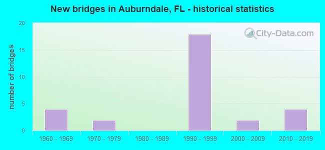
- New bridges - historical statistics
- 41960-1969
- 21970-1979
- 181990-1999
- 22000-2009
- 42010-2019
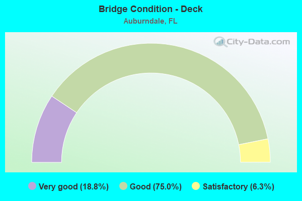
- Bridge Condition - Deck
- 18.8%Very good
- 75.0%Good
- 6.3%Satisfactory
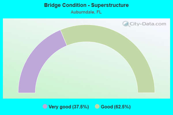
- Bridge Condition - Superstructure
- 37.5%Very good
- 62.5%Good
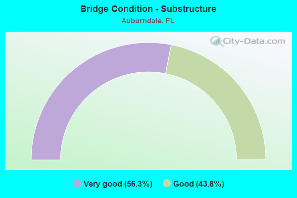
- Bridge Condition - Substructure
- 56.3%Very good
- 43.8%Good
Find on map >> Show street view
Structure Number: 160184, Location: 1.3MI E OF SR-570 (Lat: 28.157722, Lng: -81.826122), Route carried "on" structure: Interstate 4, Year Built: 1961, Year Reconstructed: 2004, Status: Open, Structure Length: 7.54m (24.74ft), Average Daily Traffic: 42,579 (year 2020), Truck Traffic: 14%, Average Future Daily Traffic: 73,874 (year 2042), Design Load: HS 20+Mod, Features Intersected: CR-655 (BERKLEY RD.)
Minimum Vertical Clearance: 30+ m (98+ ft), Kilometerpoint: 27.235, Lanes on structure: 3, Lanes under structure: 2, Base Highway Network: Yes, Owner: State Highway Agency, Approaching Roadway Width: 17.2m (56.4ft), Material/Design: Prestressed concrete, Design/Construction: Stringer/Multi-beam, Number Of Spans In Main Unit: 5, Length of Maximum Span: 18.0m (59.1ft), Curb-To-Curb Width: 17.2m (56.4ft), Out-to-Out Width: 19.0m (62.3ft)
Condition: Deck: Good, Superstructure: Very good, Substructure: Good, Operating Rating: 50.5 metric tons, Method Used To Determine Operating Rating: Load Factor (LF), Inventory Rating: 32.7 metric tons, Method Used To Determine Inventory Rating: Load Factor (LF), Structural Evaluation: Better than present minimum criteria, Deck Geometry: Better than present minimum criteria, Underclear: Somewhat better than minimum adequacy, Approach Roadway Alignment: Equal to present desirable criteria, Designated Inspection Frequency: Every 24 months, Inspection Date: July 2020, Deck Structure Type: Concrete Cast-file-Place
Find on map >> Show street view
Structure Number: 160185, Location: 1.3MI E OF SR-570 (Lat: 28.157381, Lng: -81.826011), Route carried "on" structure: Interstate 4, Year Built: 1961, Year Reconstructed: 2004, Status: Open, Structure Length: 7.54m (24.74ft), Average Daily Traffic: 42,579 (year 2020), Truck Traffic: 14%, Average Future Daily Traffic: 73,874 (year 2042), Design Load: HS 20+Mod, Features Intersected: CR-655 (BERKLEY RD.)
Minimum Vertical Clearance: 30+ m (98+ ft), Kilometerpoint: 27.235, Lanes on structure: 3, Lanes under structure: 3, Base Highway Network: Yes, Owner: State Highway Agency, Approaching Roadway Width: 17.3m (56.8ft), Material/Design: Prestressed concrete, Design/Construction: Stringer/Multi-beam, Number Of Spans In Main Unit: 5, Length of Maximum Span: 18.0m (59.1ft), Curb-To-Curb Width: 17.3m (56.8ft), Out-to-Out Width: 19.0m (62.3ft)
Condition: Deck: Good, Superstructure: Good, Substructure: Good, Operating Rating: 50.5 metric tons, Method Used To Determine Operating Rating: Load Factor (LF), Inventory Rating: 32.7 metric tons, Method Used To Determine Inventory Rating: Load Factor (LF), Structural Evaluation: Better than present minimum criteria, Deck Geometry: Better than present minimum criteria, Underclear: Somewhat better than minimum adequacy, Approach Roadway Alignment: Equal to present desirable criteria, Designated Inspection Frequency: Every 24 months, Inspection Date: July 2020, Deck Structure Type: Concrete Cast-file-Place
Find on map >> Show street view
Structure Number: 160206, Location: 0.9 MI WEST OF SR-544 (Lat: 28.059219, Lng: -81.796206), Route carried "on" structure: US 92, Year Built: 1972, Status: Open, Structure Length: 16.67m (54.69ft), Average Daily Traffic: 30,000 (year 2020), Truck Traffic: 12%, Average Future Daily Traffic: 52,050 (year 2042), Design Load: HS 20+Mod, Features Intersected: CSX R/R & MCKEAN ST
Minimum Vertical Clearance: 30+ m (98+ ft), Kilometerpoint: 16.399, Lanes on structure: 6, Lanes under structure: 2, Base Highway Network: Yes, Owner: State Highway Agency, Approaching Roadway Width: 24.0m (78.7ft), Skew: 29 degrees, Material/Design: Prestressed concrete, Design/Construction: Stringer/Multi-beam, Number Of Spans In Main Unit: 7, Length of Maximum Span: 33.8m (110.9ft), Curb or Sidewalk Widths: Left: 1.5m (4.9ft), Right: 1.5m (4.9ft), Curb-To-Curb Width: 24.0m (78.7ft), Out-to-Out Width: 31.4m (103.0ft)
Condition: Deck: Satisfactory, Superstructure: Good, Substructure: Good, Operating Rating: 49.2 metric tons, Method Used To Determine Operating Rating: Load Factor (LF), Inventory Rating: 29.5 metric tons, Method Used To Determine Inventory Rating: Load Factor (LF), Structural Evaluation: Better than present minimum criteria, Deck Geometry: Somewhat better than minimum adequacy, Underclear: Meets minimum limits, Approach Roadway Alignment: Better than present minimum criteria, Designated Inspection Frequency: Every 24 months, Inspection Date: September 2020, Deck Structure Type: Concrete Cast-file-Place
Find on map >> Show street view
Structure Number: 160265, Location: 3.8 MI EAST OF US 98 (Lat: 28.010842, Lng: -81.841936), Route carried "on" structure: State highway 570, Year Built: 1998, Status: Open, Structure Length: 2.10m (6.89ft), Average Daily Traffic: 5,650 (year 2020), Truck Traffic: 17%, Average Future Daily Traffic: 9,803 (year 2042), Design Load: HS 20, Features Intersected: LANDFILL ROAD
Minimum Vertical Clearance: 30+ m (98+ ft), Kilometerpoint: 22.389, Lanes on structure: 2, Lanes under structure: 2, Base Highway Network: Yes, Toll: On toll road, Owner: State Toll Authority, Approaching Roadway Width: 12.0m (39.4ft), Material/Design: Prestressed concrete, Design/Construction: Stringer/Multi-beam, Number Of Spans In Main Unit: 1, Length of Maximum Span: 21.0m (68.9ft), Curb-To-Curb Width: 12.2m (40.0ft), Out-to-Out Width: 13.2m (43.3ft)
Condition: Deck: Good, Superstructure: Good, Substructure: Good, Operating Rating: 50.1 metric tons, Method Used To Determine Operating Rating: Load and Resistance Factor (LRFR), Inventory Rating: 43.4 metric tons, Method Used To Determine Inventory Rating: Load and Resistance Factor (LRFR), Structural Evaluation: Better than present minimum criteria, Deck Geometry: Better than present minimum criteria, Underclear: Superior to present desirable criteria, Approach Roadway Alignment: Equal to present desirable criteria, Designated Inspection Frequency: Every 24 months, Inspection Date: April 2020, Deck Structure Type: Concrete Cast-file-Place
Find on map >> Show street view
Structure Number: 160266, Location: 3.8 MI EAST OF US 98 (Lat: 28.010597, Lng: -81.841908), Route carried "on" structure: State highway 570, Year Built: 1998, Status: Open, Structure Length: 2.10m (6.89ft), Average Daily Traffic: 5,650 (year 2020), Truck Traffic: 17%, Average Future Daily Traffic: 9,803 (year 2042), Design Load: HS 20, Features Intersected: LANDFILL ROAD
Minimum Vertical Clearance: 30+ m (98+ ft), Kilometerpoint: 22.388, Lanes on structure: 2, Lanes under structure: 2, Base Highway Network: Yes, Toll: On toll road, Owner: State Toll Authority, Approaching Roadway Width: 12.2m (40.0ft), Material/Design: Prestressed concrete, Design/Construction: Stringer/Multi-beam, Number Of Spans In Main Unit: 1, Length of Maximum Span: 21.0m (68.9ft), Curb-To-Curb Width: 12.2m (40.0ft), Out-to-Out Width: 13.2m (43.3ft)
Condition: Deck: Good, Superstructure: Very good, Substructure: Good, Operating Rating: 50.1 metric tons, Method Used To Determine Operating Rating: Load and Resistance Factor (LRFR), Inventory Rating: 43.4 metric tons, Method Used To Determine Inventory Rating: Load and Resistance Factor (LRFR), Structural Evaluation: Better than present minimum criteria, Deck Geometry: Better than present minimum criteria, Underclear: Superior to present desirable criteria, Approach Roadway Alignment: Equal to present desirable criteria, Designated Inspection Frequency: Every 24 months, Inspection Date: April 2020, Deck Structure Type: Concrete Cast-file-Place
Find on map >> Show street view
Structure Number: 160267, Location: 14.8 MI E OF I-4 WEST (Lat: 28.014850, Lng: -81.833472), Route carried "on" structure: Ramp State highway 570, Year Built: 1998, Status: Open, Structure Length: 8.42m (27.62ft), Average Daily Traffic: 1,500 (year 2020), Truck Traffic: 17%, Average Future Daily Traffic: 2,602 (year 2042), Design Load: HS 20+Mod, Features Intersected: SR 570 POLK
Minimum Vertical Clearance: 30+ m (98+ ft), Kilometerpoint: 0.362, Lanes on structure: 1, Lanes under structure: 4, Base Highway Network: Yes, Toll: On toll road, Owner: State Toll Authority, Approaching Roadway Width: 9.5m (31.2ft), Skew: 9 degrees, Material/Design: Steel continuous, Design/Construction: Stringer/Multi-beam, Number Of Spans In Main Unit: 2, Length of Maximum Span: 45.0m (147.6ft), Curb-To-Curb Width: 8.2m (26.9ft), Out-to-Out Width: 9.2m (30.2ft)
Condition: Deck: Good, Superstructure: Very good, Substructure: Very good, Operating Rating: 72.0 metric tons, Method Used To Determine Operating Rating: Load Factor (LF), Inventory Rating: 43.1 metric tons, Method Used To Determine Inventory Rating: Load Factor (LF), Structural Evaluation: Equal to present desirable criteria, Deck Geometry: Superior to present desirable criteria, Underclear: Better than present minimum criteria, Approach Roadway Alignment: Better than present minimum criteria, Designated Inspection Frequency: Every 24 months, Inspection Date: May 2020, Deck Structure Type: Concrete Cast-file-Place
Find on map >> Show street view
Structure Number: 160268, Location: 14.4 MI EAST OF I-4 WEST (Lat: 28.010425, Lng: -81.847331), Route carried "on" structure: State highway 570, Year Built: 1998, Status: Open, Structure Length: 6.49m (21.29ft), Average Daily Traffic: 5,650 (year 2020), Truck Traffic: 17%, Average Future Daily Traffic: 9,803 (year 2042), Design Load: HS 20+Mod, Features Intersected: RAMP A
Minimum Vertical Clearance: 30+ m (98+ ft), Kilometerpoint: 21.836, Lanes on structure: 2, Lanes under structure: 2, Base Highway Network: Yes, Toll: On toll road, Owner: State Toll Authority, Approaching Roadway Width: 12.2m (40.0ft), Skew: 6 degrees, Material/Design: Steel, Design/Construction: Stringer/Multi-beam, Number Of Spans In Main Unit: 1, Length of Maximum Span: 64.9m (212.9ft), Curb-To-Curb Width: 12.2m (40.0ft), Out-to-Out Width: 13.1m (43.0ft)
Condition: Deck: Good, Superstructure: Good, Substructure: Good, Inventory Rating: 62.4 metric tons, Method Used To Determine Inventory Rating: Load Factor (LF), Structural Evaluation: Better than present minimum criteria, Deck Geometry: Better than present minimum criteria, Underclear: Superior to present desirable criteria, Approach Roadway Alignment: Equal to present desirable criteria, Designated Inspection Frequency: Every 24 months, Inspection Date: May 2020, Deck Structure Type: Concrete Cast-file-Place
Find on map >> Show street view
Structure Number: 160275, Location: 17.2 MI E OF I-4 WEST (Lat: 28.051267, Lng: -81.834406), Route carried "on" structure: State highway 570, Year Built: 1998, Status: Open, Structure Length: 3.35m (10.99ft), Average Daily Traffic: 7,350 (year 2020), Truck Traffic: 17%, Average Future Daily Traffic: 12,752 (year 2042), Design Load: H 20, Features Intersected: CSX RR
Minimum Vertical Clearance: 30+ m (98+ ft), Kilometerpoint: 27.483, Lanes on structure: 3, Base Highway Network: Yes, Toll: On toll road, Owner: State Toll Authority, Approaching Roadway Width: 15.9m (52.2ft), Skew: 1 degrees, Material/Design: Prestressed concrete, Design/Construction: Stringer/Multi-beam, Number Of Spans In Main Unit: 1, Length of Maximum Span: 33.5m (109.9ft), Curb-To-Curb Width: 15.9m (52.2ft), Out-to-Out Width: 16.8m (55.1ft)
Condition: Deck: Very good, Superstructure: Good, Substructure: Very good, Operating Rating: 37.6 metric tons, Method Used To Determine Operating Rating: Load and Resistance Factor (LRFR), Inventory Rating: 33.7 metric tons, Method Used To Determine Inventory Rating: Load and Resistance Factor (LRFR), Structural Evaluation: Better than present minimum criteria, Deck Geometry: Somewhat better than minimum adequacy, Underclear: Superior to present desirable criteria, Approach Roadway Alignment: Equal to present desirable criteria, Designated Inspection Frequency: Every 24 months, Inspection Date: March 2020, Deck Structure Type: Concrete Cast-file-Place
Find on map >> Show street view
Structure Number: 160277, Location: 17.2 MI E OF I-4 WEST (Lat: 28.051222, Lng: -81.834728), Route carried "on" structure: State highway 570, Year Built: 1998, Status: Open, Structure Length: 3.37m (11.06ft), Average Daily Traffic: 7,350 (year 2020), Truck Traffic: 17%, Average Future Daily Traffic: 12,752 (year 2042), Design Load: H 20, Features Intersected: CSX RR
Minimum Vertical Clearance: 30+ m (98+ ft), Kilometerpoint: 27.486, Lanes on structure: 3, Base Highway Network: Yes, Toll: On toll road, Owner: State Toll Authority, Approaching Roadway Width: 15.9m (52.2ft), Skew: 1 degrees, Material/Design: Prestressed concrete, Design/Construction: Stringer/Multi-beam, Number Of Spans In Main Unit: 1, Length of Maximum Span: 33.7m (110.6ft), Curb-To-Curb Width: 15.9m (52.2ft), Out-to-Out Width: 16.9m (55.4ft)
Condition: Deck: Good, Superstructure: Very good, Substructure: Very good, Operating Rating: 37.6 metric tons, Method Used To Determine Operating Rating: Load and Resistance Factor (LRFR), Inventory Rating: 33.7 metric tons, Method Used To Determine Inventory Rating: Load and Resistance Factor (LRFR), Structural Evaluation: Equal to present desirable criteria, Deck Geometry: Somewhat better than minimum adequacy, Underclear: Superior to present desirable criteria, Approach Roadway Alignment: Equal to present desirable criteria, Designated Inspection Frequency: Every 24 months, Inspection Date: March 2020, Deck Structure Type: Concrete Cast-file-Place
Find on map >> Show street view
Structure Number: 160279, Location: 17.4 MI E OF I-4 WEST INT (Lat: 28.053881, Lng: -81.834725), Route carried "on" structure: State highway 570, Year Built: 1998, Status: Open, Structure Length: 5.58m (18.31ft), Average Daily Traffic: 7,350 (year 2020), Truck Traffic: 17%, Average Future Daily Traffic: 12,752 (year 2042), Design Load: HS 20+Mod, Features Intersected: US-92
Minimum Vertical Clearance: 30+ m (98+ ft), Kilometerpoint: 27.760, Lanes on structure: 4, Lanes under structure: 5, Base Highway Network: Yes, Toll: On toll road, Owner: State Toll Authority, Approaching Roadway Width: 18.4m (60.4ft), Skew: 2 degrees, Material/Design: Prestressed concrete, Design/Construction: Stringer/Multi-beam, Number Of Spans In Main Unit: 2, Length of Maximum Span: 29.9m (98.1ft), Curb-To-Curb Width: 19.6m (64.3ft), Out-to-Out Width: 20.5m (67.3ft)
Condition: Deck: Good, Superstructure: Good, Substructure: Very good, Operating Rating: 40.9 metric tons, Method Used To Determine Operating Rating: Load and Resistance Factor (LRFR), Inventory Rating: 37.4 metric tons, Method Used To Determine Inventory Rating: Load and Resistance Factor (LRFR), Structural Evaluation: Better than present minimum criteria, Deck Geometry: Somewhat better than minimum adequacy, Underclear: Better than present minimum criteria, Approach Roadway Alignment: Equal to present desirable criteria, Designated Inspection Frequency: Every 24 months, Inspection Date: March 2020, Deck Structure Type: Concrete Cast-file-Place
Find on map >> Show street view
Structure Number: 16028, Location: 17.4 MI E OF I-4 WEST INT (Lat: 28.054039, Lng: -81.834408), Route carried "on" structure: State highway 570, Year Built: 1998, Status: Open, Structure Length: 5.61m (18.41ft), Average Daily Traffic: 7,350 (year 2020), Truck Traffic: 17%, Average Future Daily Traffic: 12,752 (year 2042), Design Load: HS 20+Mod, Features Intersected: US-92
Minimum Vertical Clearance: 30+ m (98+ ft), Kilometerpoint: 27.776, Lanes on structure: 4, Lanes under structure: 5, Base Highway Network: Yes, Toll: On toll road, Owner: State Toll Authority, Approaching Roadway Width: 19.4m (63.6ft), Skew: 2 degrees, Material/Design: Prestressed concrete, Design/Construction: Stringer/Multi-beam, Number Of Spans In Main Unit: 2, Length of Maximum Span: 29.9m (98.1ft), Curb-To-Curb Width: 19.5m (64.0ft), Out-to-Out Width: 20.4m (66.9ft)
Condition: Deck: Good, Superstructure: Good, Substructure: Very good, Operating Rating: 40.9 metric tons, Method Used To Determine Operating Rating: Load and Resistance Factor (LRFR), Inventory Rating: 37.4 metric tons, Method Used To Determine Inventory Rating: Load and Resistance Factor (LRFR), Structural Evaluation: Better than present minimum criteria, Deck Geometry: Somewhat better than minimum adequacy, Underclear: Better than present minimum criteria, Approach Roadway Alignment: Equal to present desirable criteria, Designated Inspection Frequency: Every 24 months, Inspection Date: March 2020, Deck Structure Type: Concrete Cast-file-Place
Find on map >> Show street view
Structure Number: 160307, Location: 1.5 MI EAST OF SR-559 (Lat: 28.165181, Lng: -81.777264), Route carried "on" structure: County highway 557A, Year Built: 2004, Status: Open, Structure Length: 9.98m (32.74ft), Average Daily Traffic: 3,000 (year 2020), Truck Traffic: 13%, Average Future Daily Traffic: 5,205 (year 2042), Design Load: HS 20+Mod, Features Intersected: I-4 (SR-400)
Minimum Vertical Clearance: 30+ m (98+ ft), Kilometerpoint: 5.575, Lanes on structure: 2, Lanes under structure: 6, Owner: State Highway Agency, Approaching Roadway Width: 13.4m (44.0ft), Skew: 1 degrees, Material/Design: Prestressed concrete, Design/Construction: Stringer/Multi-beam, Number Of Spans In Main Unit: 2, Length of Maximum Span: 50.3m (165.0ft), Curb-To-Curb Width: 13.4m (44.0ft), Out-to-Out Width: 14.4m (47.2ft)
Condition: Deck: Very good, Superstructure: Very good, Substructure: Very good, Operating Rating: 68.9 metric tons, Method Used To Determine Operating Rating: Load Factor (LF), Inventory Rating: 20.2 metric tons, Method Used To Determine Inventory Rating: Load Factor (LF), Structural Evaluation: Somewhat better than minimum adequacy, Deck Geometry: Better than present minimum criteria, Underclear: Superior to present desirable criteria, Approach Roadway Alignment: Equal to present desirable criteria, Designated Inspection Frequency: Every 24 months, Inspection Date: August 2020, Deck Structure Type: Concrete Cast-file-Place
Find on map >> Show street view
Structure Number: 160346, Location: 0.2 MI SOUTH OF CR-544A (Lat: 28.050250, Lng: -81.790439), Route carried "on" structure: County highway 559, Year Built: 2011, Status: Open, Structure Length: 12.86m (42.19ft), Average Daily Traffic: 4,200 (year 2020), Truck Traffic: 9%, Average Future Daily Traffic: 7,287 (year 2042), Design Load: HL 93, Features Intersected: SR-655 AND CSX RR
Minimum Vertical Clearance: 30+ m (98+ ft), Kilometerpoint: 0.401, Lanes on structure: 2, Lanes under structure: 3, Owner: State Highway Agency, Approaching Roadway Width: 13.4m (44.0ft), Material/Design: Prestressed concrete, Design/Construction: Stringer/Multi-beam, Number Of Spans In Main Unit: 3, Length of Maximum Span: 42.9m (140.7ft), Curb-To-Curb Width: 13.4m (44.0ft), Out-to-Out Width: 14.4m (47.2ft)
Condition: Deck: Very good, Superstructure: Very good, Substructure: Very good, Operating Rating: 37.6 metric tons, Method Used To Determine Operating Rating: Load and Resistance Factor (LRFR), Inventory Rating: 33.9 metric tons, Method Used To Determine Inventory Rating: Load and Resistance Factor (LRFR), Structural Evaluation: Equal to present desirable criteria, Deck Geometry: Better than present minimum criteria, Underclear: Superior to present desirable criteria, Approach Roadway Alignment: Equal to present desirable criteria, Designated Inspection Frequency: Every 24 months, Inspection Date: August 2021, Deck Structure Type: Concrete Cast-file-Place
Find on map >> Show street view
Structure Number: 160348, Location: 2.4 MI SOUTH OF SR-33 (Lat: 28.157558, Lng: -81.801950), Route carried "on" structure: State highway 559, Year Built: 2016, Status: Open, Structure Length: 11.51m (37.76ft), Average Daily Traffic: 17,500 (year 2020), Truck Traffic: 17%, Average Future Daily Traffic: 30,362 (year 2042), Design Load: HL 93, Features Intersected: I-4 (SR-400)
Minimum Vertical Clearance: 30.18m (99.02ft), Kilometerpoint: 12.225, Lanes on structure: 5, Lanes under structure: 6, Owner: State Highway Agency, Approaching Roadway Width: 26.8m (87.9ft), Skew: 20 degrees, Material/Design: Prestressed concrete, Design/Construction: Stringer/Multi-beam, Number Of Spans In Main Unit: 3, Length of Maximum Span: 47.3m (155.2ft), Curb or Sidewalk Widths: Left: 1.5m (4.9ft), Right: 1.5m (4.9ft), Curb-To-Curb Width: 26.8m (87.9ft), Out-to-Out Width: 33.4m (109.6ft)
Condition: Deck: Good, Superstructure: Good, Substructure: Very good, Operating Rating: 37.6 metric tons, Method Used To Determine Operating Rating: Load and Resistance Factor (LRFR), Inventory Rating: 32.7 metric tons, Method Used To Determine Inventory Rating: Load and Resistance Factor (LRFR), Structural Evaluation: Better than present minimum criteria, Deck Geometry: Superior to present desirable criteria, Underclear: Better than present minimum criteria, Approach Roadway Alignment: Equal to present desirable criteria, Designated Inspection Frequency: Every 24 months, Inspection Date: January 2022, Deck Structure Type: Concrete Cast-file-Place
Find on map >> Show street view
Structure Number: 164507, Location: 16.4 MI E OF I-4 WEST (Lat: 28.040647, Lng: -81.833942), Route carried "on" structure: County highway 542, Year Built: 1998, Status: Open, Structure Length: 9.57m (31.40ft), Average Daily Traffic: 7,800 (year 2020), Truck Traffic: 14%, Average Future Daily Traffic: 13,533 (year 2042), Design Load: HS 20, Features Intersected: SR 570 POLK PKWY
Minimum Vertical Clearance: 30+ m (98+ ft), Kilometerpoint: 10.720, Lanes on structure: 2, Lanes under structure: 4, Owner: State Toll Authority, Approaching Roadway Width: 11.3m (37.1ft), Skew: 5 degrees, Material/Design: Steel continuous, Design/Construction: Stringer/Multi-beam, Number Of Spans In Main Unit: 2, Length of Maximum Span: 47.9m (157.2ft), Curb-To-Curb Width: 12.4m (40.7ft), Out-to-Out Width: 13.3m (43.6ft)
Condition: Deck: Good, Superstructure: Good, Substructure: Good, Operating Rating: 54.9 metric tons, Method Used To Determine Operating Rating: Load Factor (LF), Inventory Rating: 32.9 metric tons, Method Used To Determine Inventory Rating: Load Factor (LF), Structural Evaluation: Better than present minimum criteria, Deck Geometry: Somewhat better than minimum adequacy, Underclear: Equal to present desirable criteria, Approach Roadway Alignment: Equal to present desirable criteria, Designated Inspection Frequency: Every 24 months, Inspection Date: April 2020, Deck Structure Type: Concrete Cast-file-Place
Find on map >> Show street view
Structure Number: 164508, Location: 3.5MI W OF I-4 E INTRCHNG (Lat: 28.103794, Lng: -81.830722), Route carried "on" structure: City street , Year Built: 1999, Status: Open, Structure Length: 6.05m (19.85ft), Average Daily Traffic: 9,100 (year 2020), Truck Traffic: 17%, Average Future Daily Traffic: 15,788 (year 2042), Design Load: HS 20, Features Intersected: SR 570 POLK PKWY, Facility Carried by Structure: SPRING ROAD 20.7
Minimum Vertical Clearance: 30+ m (98+ ft), Kilometerpoint: 33.344, Lanes on structure: 2, Lanes under structure: 2, Owner: State Toll Authority, Approaching Roadway Width: 11.0m (36.1ft), Material/Design: Prestressed concrete, Design/Construction: Stringer/Multi-beam, Number Of Spans In Main Unit: 2, Length of Maximum Span: 30.4m (99.7ft), Curb or Sidewalk Widths: Left: 4.6m (15.1ft), Right: 0.0m, Curb-To-Curb Width: 11.0m (36.1ft), Out-to-Out Width: 16.8m (55.1ft)
Condition: Deck: Good, Superstructure: Good, Substructure: Very good, Inventory Rating: 59.4 metric tons, Method Used To Determine Inventory Rating: Load Factor (LF), Structural Evaluation: Better than present minimum criteria, Deck Geometry: Meets minimum limits, Underclear: Equal to present desirable criteria, Approach Roadway Alignment: Equal to present desirable criteria, Designated Inspection Frequency: Every 24 months, Inspection Date: April 2020, Deck Structure Type: Concrete Cast-file-Place
Find on map >> Show street view
Structure Number: 160184, Location: 1.3MI E OF SR-570 (Lat: 28.157722, Lng: -81.826122), Route carried "under" structure: County highway 655, Year Built: 1961, Structure Length: 0. m, Average Daily Traffic: 500 (year 2018), Truck Traffic: 10%, Features Intersected: CR-655 (BERKLEY RD.), Facility Carried by Structure: I-4 WB (SR-400)
Minimum Vertical Clearance: 7.01m (23.00ft), Kilometerpoint: 0.000, Lanes on structure: 3, Lanes under structure: 2, Material/Design: Prestressed concrete, Design/Construction: Stringer/Multi-beam, Length of Maximum Span: 18.0m (59.1ft)
Find on map >> Show street view
Structure Number: 160185, Location: 1.3MI E OF SR-570 (Lat: 28.157381, Lng: -81.826011), Route carried "under" structure: County highway 655, Year Built: 1961, Structure Length: 0. m, Average Daily Traffic: 500 (year 2019), Truck Traffic: 10%, Features Intersected: CR-655 (BERKLEY RD.), Facility Carried by Structure: I-4 EB (SR-400)
Minimum Vertical Clearance: 7.01m (23.00ft), Kilometerpoint: 0.000, Lanes on structure: 3, Lanes under structure: 2, Material/Design: Prestressed concrete, Design/Construction: Stringer/Multi-beam, Length of Maximum Span: 18.0m (59.1ft)
Find on map >> Show street view
Structure Number: 160206, Location: 0.9 MI WEST OF SR-544 (Lat: 28.059219, Lng: -81.796206), Route carried "under" structure: County highway , Year Built: 1972, Structure Length: 0. m, Average Daily Traffic: 3,500 (year 2020), Truck Traffic: 15%, Features Intersected: CSX R/R & MCKEAN ST, Facility Carried by Structure: US-92 (SR-600)
Minimum Vertical Clearance: 6.52m (21.39ft), Kilometerpoint: 0.000, Lanes on structure: 6, Lanes under structure: 2, Material/Design: Prestressed concrete, Design/Construction: Stringer/Multi-beam, Length of Maximum Span: 33.8m (110.9ft)
Find on map >> Show street view
Structure Number: 160265, Location: 3.8 MI EAST OF US 98 (Lat: 28.010842, Lng: -81.841936), Route carried "under" structure: County highway , Year Built: 1998, Structure Length: 0. m, Average Daily Traffic: 5,650 (year 2020), Truck Traffic: 17%, Features Intersected: LANDFILL ROAD, Facility Carried by Structure: SR570 WB POLK 13.9
Minimum Vertical Clearance: 5.08m (16.67ft), Kilometerpoint: 22.389, Lanes on structure: 2, Lanes under structure: 2, Material/Design: Prestressed concrete, Design/Construction: Stringer/Multi-beam, Length of Maximum Span: 21.0m (68.9ft)
Find on map >> Show street view
Structure Number: 160266, Location: 3.8 MI EAST OF US 98 (Lat: 28.010597, Lng: -81.841908), Route carried "under" structure: County highway , Year Built: 1998, Structure Length: 0. m, Average Daily Traffic: 5,650 (year 2020), Truck Traffic: 17%, Features Intersected: LANDFILL ROAD, Facility Carried by Structure: SR570 EB POLK 13.9
Minimum Vertical Clearance: 5.23m (17.16ft), Kilometerpoint: 22.388, Lanes on structure: 2, Lanes under structure: 2, Material/Design: Prestressed concrete, Design/Construction: Stringer/Multi-beam, Length of Maximum Span: 21.0m (68.9ft)
Find on map >> Show street view
Structure Number: 160267, Location: 14.8 MI E OF I-4 WEST (Lat: 28.014850, Lng: -81.833472), Route carried "under" structure: State highway 570, Year Built: 1998, Structure Length: 0. m, Average Daily Traffic: 14,700 (year 2020), Truck Traffic: 17%, Features Intersected: SR 570 POLK
Minimum Vertical Clearance: 5.13m (16.83ft), Kilometerpoint: 23.368, Lanes on structure: 1, Lanes under structure: 4, Toll: On toll road, Material/Design: Steel continuous, Design/Construction: Stringer/Multi-beam, Length of Maximum Span: 45.0m (147.6ft)
Find on map >> Show street view
Structure Number: 160268, Location: 14.4 MI EAST OF I-4 WEST (Lat: 28.010425, Lng: -81.847331), Route carried "under" structure: Ramp State highway 570, Year Built: 1998, Structure Length: 0. m, Average Daily Traffic: 5,500 (year 2020), Truck Traffic: 17%, Features Intersected: RAMP A
Minimum Vertical Clearance: 5.03m (16.50ft), Kilometerpoint: 0.533, Lanes on structure: 2, Lanes under structure: 2, Toll: On toll road, Material/Design: Steel, Design/Construction: Stringer/Multi-beam, Length of Maximum Span: 64.9m (212.9ft)
Find on map >> Show street view
Structure Number: 160279, Location: 17.4 MI E OF I-4 WEST INT (Lat: 28.053881, Lng: -81.834725), Route carried "under" structure: US 92, Year Built: 1998, Structure Length: 0. m, Average Daily Traffic: 32,500 (year 2020), Truck Traffic: 11%, Features Intersected: US-92, Facility Carried by Structure: SR570 WB POLK 17.2
Minimum Vertical Clearance: 5.87m (19.26ft), Kilometerpoint: 12.505, Lanes on structure: 4, Lanes under structure: 5, Material/Design: Prestressed concrete, Design/Construction: Stringer/Multi-beam, Length of Maximum Span: 29.9m (98.1ft)
Find on map >> Show street view
Structure Number: 16028, Location: 17.4 MI E OF I-4 WEST INT (Lat: 28.054039, Lng: -81.834408), Route carried "under" structure: US 92, Year Built: 1998, Structure Length: 0. m, Average Daily Traffic: 32,500 (year 2020), Truck Traffic: 11%, Features Intersected: US-92, Facility Carried by Structure: SR570 EB Polk 17.2
Minimum Vertical Clearance: 5.13m (16.83ft), Kilometerpoint: 12.543, Lanes on structure: 4, Lanes under structure: 5, Material/Design: Prestressed concrete, Design/Construction: Stringer/Multi-beam, Length of Maximum Span: 29.9m (98.1ft)
Find on map >> Show street view
Structure Number: 160307, Location: 1.5 MI EAST OF SR-559 (Lat: 28.165181, Lng: -81.777264), Route carried "under" structure: Interstate 4, Year Built: 2004, Structure Length: 0. m, Average Daily Traffic: 84,000 (year 2020), Truck Traffic: 16%, Features Intersected: I-4 (SR-400), Facility Carried by Structure: CR-557A
Minimum Vertical Clearance: 5.70m (18.70ft), Kilometerpoint: 32.314, Lanes on structure: 2, Lanes under structure: 6, Material/Design: Prestressed concrete, Design/Construction: Stringer/Multi-beam, Length of Maximum Span: 50.3m (165.0ft)
Find on map >> Show street view
Structure Number: 160346, Location: 0.2 MI SOUTH OF CR-544A (Lat: 28.050250, Lng: -81.790439), Route carried "under" structure: State highway 655, Year Built: 2011, Structure Length: 0. m, Average Daily Traffic: 12,300 (year 2020), Truck Traffic: 10%, Features Intersected: SR-655 AND CSX RR, Facility Carried by Structure: CR-559 (MAIN ST.)
Minimum Vertical Clearance: 5.43m (17.81ft), Kilometerpoint: 8.613, Lanes on structure: 2, Lanes under structure: 3, Material/Design: Prestressed concrete, Design/Construction: Stringer/Multi-beam, Length of Maximum Span: 42.9m (140.7ft)
Find on map >> Show street view
Structure Number: 160348, Location: 2.4 MI SOUTH OF SR-33 (Lat: 28.157558, Lng: -81.801950), Route carried "under" structure: Interstate 4, Year Built: 2016, Structure Length: 0. m, Average Daily Traffic: 84,000 (year 2020), Truck Traffic: 14%, Features Intersected: I-4 (SR-400), Facility Carried by Structure: SR-559
Minimum Vertical Clearance: 6.16m (20.21ft), Kilometerpoint: 29.636, Lanes on structure: 5, Lanes under structure: 6, Material/Design: Prestressed concrete, Design/Construction: Stringer/Multi-beam, Length of Maximum Span: 47.3m (155.2ft)
Find on map >> Show street view
Structure Number: 164507, Location: 16.4 MI E OF I-4 WEST (Lat: 28.040647, Lng: -81.833942), Route carried "under" structure: State highway 570, Year Built: 1998, Structure Length: 0. m, Average Daily Traffic: 14,700 (year 2020), Truck Traffic: 17%, Features Intersected: SR 570 POLK PKWY, Facility Carried by Structure: CR 542 16.3
Minimum Vertical Clearance: 5.18m (16.99ft), Kilometerpoint: 26.308, Lanes on structure: 2, Lanes under structure: 4, Toll: On toll road, Material/Design: Steel continuous, Design/Construction: Stringer/Multi-beam, Length of Maximum Span: 47.9m (157.2ft)
Find on map >> Show street view
Structure Number: 164508, Location: 3.5MI W OF I-4 E INTRCHNG (Lat: 28.103794, Lng: -81.830722), Route carried "under" structure: State highway 570, Year Built: 1999, Structure Length: 0. m, Average Daily Traffic: 9,100 (year 2020), Truck Traffic: 17%, Features Intersected: SR 570 POLK PKWY, Facility Carried by Structure: SPRING ROAD 20.7
Minimum Vertical Clearance: 5.23m (17.16ft), Kilometerpoint: 33.344, Lanes on structure: 2, Lanes under structure: 2, Toll: On toll road, Material/Design: Prestressed concrete, Design/Construction: Stringer/Multi-beam, Length of Maximum Span: 30.4m (99.7ft)