Bridge Statistics for Aumsville, Oregon (OR)
Condition, Traffic, Stress, Structural Evaluation, Project Costs
- National Bridge Inventory (NBI) Statistics
- 20Number of bridges
- 305ft / 92.8mTotal length
- $1,778,000Total costs
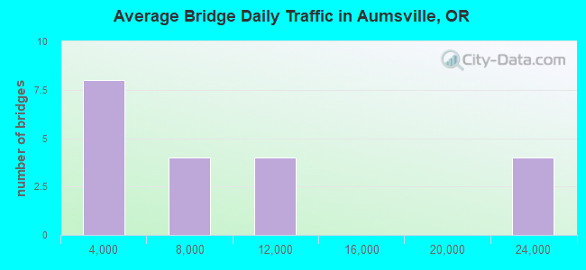
- 157,969Total average daily traffic
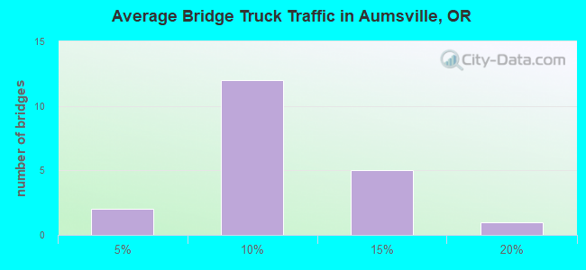
- 12,793Total average daily truck traffic
- National Bridge Inventory (NBI) Registered Bridges for Aumsville
- No street view available for this location
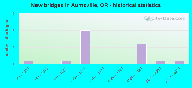
- New bridges - historical statistics
- 11930-1939
- 11950-1959
- 101960-1969
- 61990-1999
- 12000-2009
- 12010-2019
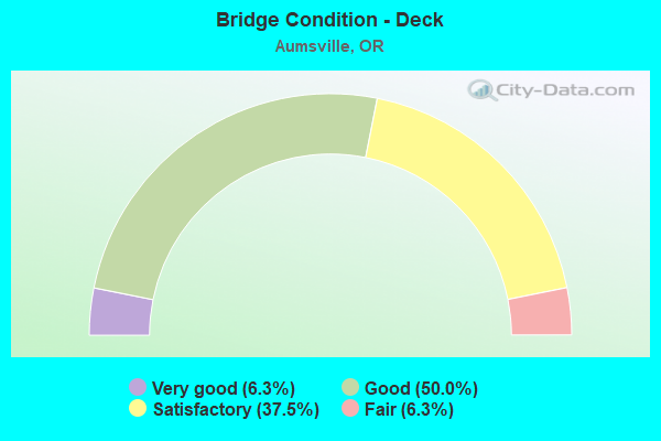
- Bridge Condition - Deck
- 6.3%Very good
- 50.0%Good
- 37.5%Satisfactory
- 6.3%Fair
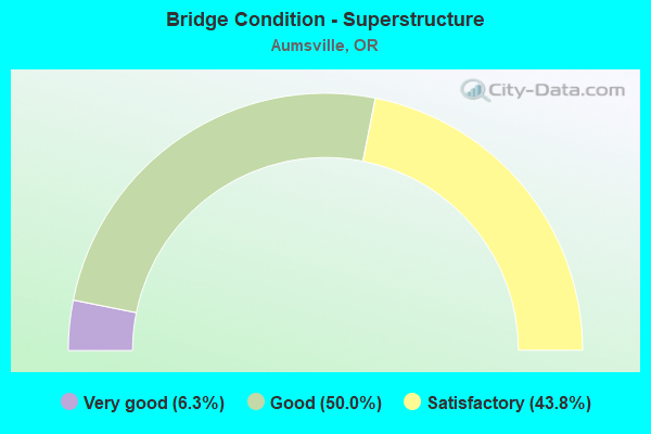
- Bridge Condition - Superstructure
- 6.3%Very good
- 50.0%Good
- 43.8%Satisfactory
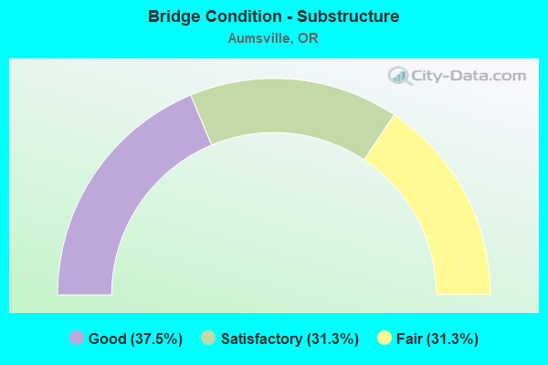
- Bridge Condition - Substructure
- 37.5%Good
- 31.3%Satisfactory
- 31.3%Fair
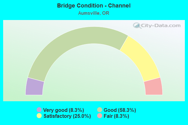
- Bridge Condition - Channel
- 8.3%Very good
- 58.3%Good
- 25.0%Satisfactory
- 8.3%Fair
Find on map >> Show street view
Structure Number: 1506 028, Location: 00.4 EAST OF 70TH AVE (Lat: 44.838719, Lng: -122.907969), Route carried "on" structure: County highway C0028, Year Built: 1930, Status: Open, Structure Length: 1.86m (6.10ft), Average Daily Traffic: 4,699 (year 2020), Truck Traffic: 3%, Average Future Daily Traffic: 5,279 (year 2025), Design Load: H 20, Features Intersected: MILL CREEK, Facility Carried by Structure: MILL CR RD
Minimum Vertical Clearance: 30+ m (98+ ft), Kilometerpoint: 3.154, Lanes on structure: 2, Owner: County Highway Agency, Approaching Roadway Width: 8.5m (27.9ft), Skew: 2 degrees, Material/Design: Concrete continuous, Design/Construction: Tee Beam, Number Of Spans In Main Unit: 2, Length of Maximum Span: 9.1m (29.9ft), Curb-To-Curb Width: 7.3m (24.0ft), Out-to-Out Width: 8.2m (26.9ft)
Condition: Deck: Satisfactory, Superstructure: Satisfactory, Substructure: Fair, Channel: Satisfactory, Operating Rating: 23.0 metric tons, Method Used To Determine Operating Rating: Load and Resistance Factor Rating (LRFR) rating reported by rating factor(RF) method using HL-93 loadings, Inventory Rating: 17.5 metric tons, Method Used To Determine Inventory Rating: Load and Resistance Factor Rating (LRFR) rating reported by rating factor(RF) method using HL-93 loadings, Structural Evaluation: Meets minimum limits, Deck Geometry: High priority of replacement, Waterway Adequacy: Somewhat better than minimum adequacy, Approach Roadway Alignment: Equal to present desirable criteria, Length Of Structure Improvement: 1.90m (6.23ft), Designated Inspection Frequency: Every 24 months, Underwater Inspection Frequency: Every 60 months, Inspection Date: August 2020, Underwater Inspection Date: April 2021, Bridge Improvement Cost: $195,000, Roadway Improvement Cost: $20,000, Total Project Cost: $313,000, Deck Structure Type: Concrete Cast-file-Place, Wearing Surface/Protective System: Wearing Surface: Bituminous
Find on map >> Show street view
Structure Number: 6008A028, Location: 00.3 WEST OF AUMSVILLE (Lat: 44.839939, Lng: -122.879381), Route carried "on" structure: County highway C0028, Year Built: 1955, Status: Open, Structure Length: 2.29m (7.51ft), Average Daily Traffic: 5,400 (year 2018), Truck Traffic: 19%, Average Future Daily Traffic: 6,200 (year 2038), Design Load: HS 20, Features Intersected: MILL CREEK, Facility Carried by Structure: MILL CR RD
Minimum Vertical Clearance: 30+ m (98+ ft), Kilometerpoint: 5.472, Lanes on structure: 2, Owner: County Highway Agency, Approaching Roadway Width: 9.1m (29.9ft), Material/Design: Concrete continuous, Design/Construction: Slab, Number Of Spans In Main Unit: 3, Length of Maximum Span: 8.8m (28.9ft), Curb or Sidewalk Widths: Left: 0.5m (1.6ft), Right: 0.5m (1.6ft), Curb-To-Curb Width: 7.3m (24.0ft), Out-to-Out Width: 8.5m (27.9ft)
Condition: Deck: Good, Superstructure: Good, Substructure: Fair, Channel: Good, Operating Rating: 26.6 metric tons, Method Used To Determine Operating Rating: Load and Resistance Factor Rating (LRFR) rating reported by rating factor(RF) method using HL-93 loadings, Inventory Rating: 20.4 metric tons, Method Used To Determine Inventory Rating: Load and Resistance Factor Rating (LRFR) rating reported by rating factor(RF) method using HL-93 loadings, Structural Evaluation: Somewhat better than minimum adequacy, Deck Geometry: High priority of replacement, Waterway Adequacy: Better than present minimum criteria, Approach Roadway Alignment: Equal to present minimum criteria, Length Of Structure Improvement: 2.30m (7.55ft), Designated Inspection Frequency: Every 24 months, Underwater Inspection Frequency: Every 60 months, Inspection Date: August 2020, Underwater Inspection Date: May 2018, Bridge Improvement Cost: $247,000, Roadway Improvement Cost: $25,000, Total Project Cost: $395,000, Deck Structure Type: Concrete Cast-file-Place, Wearing Surface/Protective System: Wearing Surface: Bituminous
Find on map >> Show street view
Structure Number: 8076 162 00888, Location: 070 MI E SALEM (Lat: 44.853011, Lng: -122.867100), Route carried "on" structure: State highway 22, Year Built: 1960, Status: Open, Structure Length: 3.87m (12.70ft), Average Daily Traffic: 10,292 (year 2020), Truck Traffic: 8%, Average Future Daily Traffic: 11,800 (year 2040), Design Load: HS 20, Features Intersected: Beaver Creek
Minimum Vertical Clearance: 30+ m (98+ ft), Kilometerpoint: 14.291, Lanes on structure: 2, Base Highway Network: Yes, Owner: State Highway Agency, Approaching Roadway Width: 16.6m (54.5ft), Skew: 4 degrees, Material/Design: Concrete continuous, Design/Construction: Tee Beam, Number Of Spans In Main Unit: 3, Length of Maximum Span: 14.9m (48.9ft), Curb-To-Curb Width: 16.6m (54.5ft), Out-to-Out Width: 18.0m (59.1ft)
Condition: Deck: Satisfactory, Superstructure: Satisfactory, Substructure: Satisfactory, Channel: Good, Operating Rating: 39.0 metric tons, Method Used To Determine Operating Rating: Load Factor (LF), Inventory Rating: 23.6 metric tons, Method Used To Determine Inventory Rating: Load Factor (LF), Structural Evaluation: Somewhat better than minimum adequacy, Deck Geometry: Superior to present desirable criteria, Waterway Adequacy: Equal to present desirable criteria, Approach Roadway Alignment: Equal to present desirable criteria, Designated Inspection Frequency: Every 24 months, Inspection Date: August 2021, Deck Structure Type: Concrete Cast-file-Place, Wearing Surface/Protective System: Wearing Surface: Bituminous
Find on map >> Show street view
Structure Number: 8077 162 01004, Location: 015 MI W HWY 165 JCT (Lat: 44.842931, Lng: -122.848019), Route carried "on" structure: County highway , Year Built: 1960, Status: Open, Structure Length: 8.41m (27.59ft), Average Daily Traffic: 20,584 (year 2020), Truck Traffic: 8%, Average Future Daily Traffic: 23,600 (year 2040), Design Load: HS 20, Features Intersected: OR 22 (Hwy 162), Facility Carried by Structure: Albus Rd.
Minimum Vertical Clearance: 30+ m (98+ ft), Kilometerpoint: 16.158, Lanes on structure: 2, Lanes under structure: 4, Owner: State Highway Agency, Approaching Roadway Width: 7.3m (24.0ft), Skew: 3 degrees, Material/Design: Prestressed concrete, Design/Construction: Stringer/Multi-beam, Number Of Spans In Main Unit: 5, Length of Maximum Span: 18.0m (59.1ft), Curb-To-Curb Width: 7.3m (24.0ft), Out-to-Out Width: 8.8m (28.9ft)
Condition: Deck: Satisfactory, Superstructure: Satisfactory, Substructure: Satisfactory, Operating Rating: 51.7 metric tons, Method Used To Determine Operating Rating: Load Factor (LF), Inventory Rating: 30.8 metric tons, Method Used To Determine Inventory Rating: Load Factor (LF), Structural Evaluation: Equal to present minimum criteria, Deck Geometry: High priority of replacement, Underclear: Meets minimum limits, Approach Roadway Alignment: Equal to present desirable criteria, Designated Inspection Frequency: Every 24 months, Inspection Date: August 2021, Deck Structure Type: Concrete Cast-file-Place, Wearing Surface/Protective System: Wearing Surface: Monolithic Concrete
Find on map >> Show street view
Structure Number: 8471 162 00667, Location: 6.67 Mi E of Salem (Lat: 44.872600, Lng: -122.902600), Route carried "on" structure: State highway 22, Year Built: 1960, Status: Open, Structure Length: 4.30m (14.11ft), Average Daily Traffic: 11,427 (year 2020), Truck Traffic: 6%, Average Future Daily Traffic: 15,400 (year 2040), Design Load: HS 20, Features Intersected: OR 214 (Hwy 163)
Minimum Vertical Clearance: 30+ m (98+ ft), Kilometerpoint: 10.734, Lanes on structure: 2, Lanes under structure: 2, Base Highway Network: Yes, Owner: State Highway Agency, Approaching Roadway Width: 9.1m (29.9ft), Skew: 3 degrees, Material/Design: Prestressed concrete, Design/Construction: Stringer/Multi-beam, Number Of Spans In Main Unit: 3, Length of Maximum Span: 20.1m (65.9ft), Curb-To-Curb Width: 9.1m (29.9ft), Out-to-Out Width: 10.6m (34.8ft)
Condition: Deck: Fair, Superstructure: Satisfactory, Substructure: Satisfactory, Operating Rating: 31.1 metric tons, Method Used To Determine Operating Rating: Load and Resistance Factor Rating (LRFR) rating reported by rating factor(RF) method using HL-93 loadings, Inventory Rating: 24.0 metric tons, Method Used To Determine Inventory Rating: Load and Resistance Factor Rating (LRFR) rating reported by rating factor(RF) method using HL-93 loadings, Structural Evaluation: Somewhat better than minimum adequacy, Deck Geometry: Meets minimum limits, Underclear: Meets minimum limits, Approach Roadway Alignment: Equal to present desirable criteria, Designated Inspection Frequency: Every 24 months, Inspection Date: August 2021, Deck Structure Type: Concrete Cast-file-Place, Wearing Surface/Protective System: Wearing Surface: Bituminous, Membrane: Built-up
Find on map >> Show street view
Structure Number: 17418 162 00667, Location: 0.3 MI E HWY 163 JCT (Lat: 44.872689, Lng: -122.902111), Route carried "on" structure: State highway 22, Year Built: 1997, Status: Open, Structure Length: 6.16m (20.21ft), Average Daily Traffic: 11,427 (year 2020), Truck Traffic: 6%, Average Future Daily Traffic: 15,400 (year 2040), Design Load: HS 25 or greater, Features Intersected: OR 214 (Hwy 163)
Minimum Vertical Clearance: 30+ m (98+ ft), Kilometerpoint: 10.734, Lanes on structure: 2, Lanes under structure: 2, Base Highway Network: Yes, Owner: State Highway Agency, Approaching Roadway Width: 12.8m (42.0ft), Skew: 3 degrees, Material/Design: Prestressed concrete continuous, Design/Construction: Stringer/Multi-beam, Number Of Spans In Main Unit: 3, Length of Maximum Span: 37.2m (122.0ft), Curb-To-Curb Width: 12.8m (42.0ft), Out-to-Out Width: 13.6m (44.6ft)
Condition: Deck: Good, Superstructure: Good, Substructure: Good, Operating Rating: 51.2 metric tons, Method Used To Determine Operating Rating: Load and Resistance Factor Rating (LRFR) rating reported by rating factor(RF) method using HL-93 loadings, Inventory Rating: 39.5 metric tons, Method Used To Determine Inventory Rating: Load and Resistance Factor Rating (LRFR) rating reported by rating factor(RF) method using HL-93 loadings, Structural Evaluation: Better than present minimum criteria, Deck Geometry: Equal to present desirable criteria, Underclear: Equal to present minimum criteria, Approach Roadway Alignment: Equal to present desirable criteria, Designated Inspection Frequency: Every 24 months, Inspection Date: August 2021, Deck Structure Type: Concrete Cast-file-Place, Wearing Surface/Protective System: Wearing Surface: Monolithic Concrete, Deck Protection: Epoxy Coated Reinforcing
Find on map >> Show street view
Structure Number: 17424 162 0089, Location: 6.1 MI E SALEM (Lat: 44.853061, Lng: -122.866550), Route carried "on" structure: State highway 22, Year Built: 1997, Status: Open, Structure Length: 3.51m (11.52ft), Average Daily Traffic: 10,292 (year 2020), Truck Traffic: 8%, Average Future Daily Traffic: 11,800 (year 2040), Design Load: HS 25 or greater, Features Intersected: Beaver Creek
Minimum Vertical Clearance: 30+ m (98+ ft), Kilometerpoint: 14.291, Lanes on structure: 3, Base Highway Network: Yes, Owner: State Highway Agency, Approaching Roadway Width: 18.7m (61.4ft), Skew: 5 degrees, Material/Design: Prestressed concrete, Design/Construction: Stringer/Multi-beam, Number Of Spans In Main Unit: 2, Length of Maximum Span: 17.5m (57.4ft), Curb-To-Curb Width: 18.7m (61.4ft), Out-to-Out Width: 19.6m (64.3ft)
Condition: Deck: Satisfactory, Superstructure: Good, Substructure: Good, Channel: Good, Operating Rating: 42.1 metric tons, Method Used To Determine Operating Rating: Load and Resistance Factor Rating (LRFR) rating reported by rating factor(RF) method using HL-93 loadings, Inventory Rating: 32.4 metric tons, Method Used To Determine Inventory Rating: Load and Resistance Factor Rating (LRFR) rating reported by rating factor(RF) method using HL-93 loadings, Structural Evaluation: Better than present minimum criteria, Deck Geometry: Superior to present desirable criteria, Waterway Adequacy: Equal to present desirable criteria, Approach Roadway Alignment: Equal to present desirable criteria, Designated Inspection Frequency: Every 24 months, Inspection Date: August 2021, Deck Structure Type: Concrete Cast-file-Place, Wearing Surface/Protective System: Wearing Surface: Monolithic Concrete, Deck Protection: Epoxy Coated Reinforcing
Find on map >> Show street view
Structure Number: 18016 162 0089, Location: 7.0 MI E SALEM (Lat: 44.852589, Lng: -122.866081), Route carried "on" structure: County highway , Year Built: 1997, Status: Open, Structure Length: 13.41m (44.00ft), Average Daily Traffic: 20,584 (year 2020), Truck Traffic: 8%, Average Future Daily Traffic: 23,600 (year 2040), Design Load: HS 25 or greater, Features Intersected: Hwy 162 (OR 22), Facility Carried by Structure: Aumsville-Shaw Hwy
Minimum Vertical Clearance: 30+ m (98+ ft), Kilometerpoint: 14.388, Lanes on structure: 2, Lanes under structure: 6, Owner: State Highway Agency, Approaching Roadway Width: 12.2m (40.0ft), Material/Design: Prestressed concrete continuous, Design/Construction: Box Beam or Girders - Multiple, Number Of Spans In Main Unit: 2, Length of Maximum Span: 67.1m (220.1ft), Curb-To-Curb Width: 12.2m (40.0ft), Out-to-Out Width: 13.2m (43.3ft)
Condition: Deck: Satisfactory, Superstructure: Good, Substructure: Good, Operating Rating: 23.7 metric tons, Method Used To Determine Operating Rating: Load and Resistance Factor Rating (LRFR) rating reported by rating factor(RF) method using HL-93 loadings, Inventory Rating: 18.1 metric tons, Method Used To Determine Inventory Rating: Load and Resistance Factor Rating (LRFR) rating reported by rating factor(RF) method using HL-93 loadings, Structural Evaluation: Meets minimum limits, Deck Geometry: Somewhat better than minimum adequacy, Underclear: Meets minimum limits, Approach Roadway Alignment: Equal to present desirable criteria, Designated Inspection Frequency: Every 24 months, Inspection Date: August 2021, Deck Structure Type: Concrete Cast-file-Place, Wearing Surface/Protective System: Wearing Surface: Monolithic Concrete, Deck Protection: Epoxy Coated Reinforcing
Find on map >> Show street view
Structure Number: 18174 858, Location: 006 MI WEST AUMSVILLE (Lat: 44.850339, Lng: -122.892811), Route carried "on" structure: County highway C0858, Year Built: 1996, Status: Open, Structure Length: 2.32m (7.61ft), Average Daily Traffic: 870 (year 2020), Truck Traffic: 10%, Average Future Daily Traffic: 970 (year 2025), Design Load: HS 25 or greater, Features Intersected: BEAVER CREEK, Facility Carried by Structure: OLNEY ST
Minimum Vertical Clearance: 30+ m (98+ ft), Kilometerpoint: 3.718, Lanes on structure: 2, Owner: County Highway Agency, Approaching Roadway Width: 9.1m (29.9ft), Skew: 2 degrees, Material/Design: Prestressed concrete, Design/Construction: Slab, Number Of Spans In Main Unit: 2, Length of Maximum Span: 11.3m (37.1ft), Curb-To-Curb Width: 12.2m (40.0ft), Out-to-Out Width: 12.3m (40.4ft)
Condition: Deck: Good, Superstructure: Good, Substructure: Good, Channel: Good, Operating Rating: 71.7 metric tons, Method Used To Determine Operating Rating: Load Factor (LF), Inventory Rating: 43.5 metric tons, Method Used To Determine Inventory Rating: Load Factor (LF), Structural Evaluation: Better than present minimum criteria, Deck Geometry: Equal to present desirable criteria, Waterway Adequacy: Better than present minimum criteria, Approach Roadway Alignment: Equal to present minimum criteria, Designated Inspection Frequency: Every 24 months, Inspection Date: August 2020, Deck Structure Type: Concrete Precast Panels, Wearing Surface/Protective System: Wearing Surface: Bituminous, Membrane: Preformed Fabric, Deck Protection: Epoxy Coated Reinforcing
Find on map >> Show street view
Structure Number: 20136, Location: MULTNOMAH CHANNEL MP 205 (Lat: 45.628011, Lng: -122.815989), Route carried "on" structure: County highway , Year Built: 2008, Status: Open, Structure Length: 35.88m (117.72ft), Average Daily Traffic: 5,463 (year 2020), Truck Traffic: 10%, Average Future Daily Traffic: 6,008 (year 2025), Design Load: HL 93, Features Intersected: MULTNOMAH CHANNEL, Facility Carried by Structure: Sauvie Island Rd.
Minimum Vertical Clearance: 7.97m (26.15ft), Kilometerpoint: 0.000, Lanes on structure: 2, Lanes under structure: 4, Base Highway Network: Yes, Owner: County Highway Agency, Approaching Roadway Width: 11.0m (36.1ft), Navigation Control: Yes ( Vertical Clearance: 16.0m (52.5ft), Horizontal Clearance: 53.3m (174.9ft)), Material/Design: Steel, Design/Construction: Arch - Thru, Number Of Spans In Main Unit: 1, Number Of Approach Spans: 4, Length of Maximum Span: 111.3m (365.2ft), Curb or Sidewalk Widths: Left: 1.8m (5.9ft), Right: 1.8m (5.9ft), Curb-To-Curb Width: 11.0m (36.1ft), Out-to-Out Width: 20.2m (66.3ft)
Condition: Deck: Good, Superstructure: Good, Substructure: Good, Channel: Good, Operating Rating: 12.3 metric tons, Method Used To Determine Operating Rating: Load and Resistance Factor Rating (LRFR) rating reported by rating factor(RF) method using HL-93 loadings, Inventory Rating: 9.4 metric tons, Method Used To Determine Inventory Rating: Load and Resistance Factor Rating (LRFR) rating reported by rating factor(RF) method using HL-93 loadings, Structural Evaluation: High priority of corrective action, Deck Geometry: Meets minimum limits, Underclear: Better than present minimum criteria, Waterway Adequacy: Equal to present desirable criteria, Approach Roadway Alignment: Equal to present minimum criteria, Designated Inspection Frequency: Every 24 months, Critical Feature Inspection Frequency: Every 24 months, Underwater Inspection Frequency: Every 60 months, Inspection Date: September 2021, Critical Feature Inspection Date: September 2021, Underwater Inspection Date: September 2021, Deck Structure Type: Concrete Cast-file-Place, Wearing Surface/Protective System: Wearing Surface: Monolithic Concrete, Deck Protection: Epoxy Coated Reinforcing
Find on map >> Show street view
Structure Number: 21238 163 01391, Location: 003 MI E DRIFT CREEK RD (Lat: 44.865531, Lng: -122.824600), Route carried "on" structure: Alternate State highway 214, Year Built: 2012, Status: Open, Structure Length: 1.17m (3.84ft), Average Daily Traffic: 1,453 (year 2020), Truck Traffic: 14%, Average Future Daily Traffic: 1,700 (year 2040), Design Load: HL 93, Features Intersected: Creek
Minimum Vertical Clearance: 30+ m (98+ ft), Kilometerpoint: 22.386, Lanes on structure: 2, Owner: State Highway Agency, Approaching Roadway Width: 11.4m (37.4ft), Material/Design: Prestressed concrete, Design/Construction: Slab, Number Of Spans In Main Unit: 1, Length of Maximum Span: 11.7m (38.4ft), Curb-To-Curb Width: 11.4m (37.4ft), Out-to-Out Width: 12.2m (40.0ft)
Condition: Deck: Very good, Superstructure: Very good, Substructure: Good, Channel: Very good, Operating Rating: 80.4 metric tons, Method Used To Determine Operating Rating: Load and Resistance Factor Rating (LRFR) rating reported by rating factor(RF) method using HL-93 loadings, Inventory Rating: 61.9 metric tons, Method Used To Determine Inventory Rating: Load and Resistance Factor Rating (LRFR) rating reported by rating factor(RF) method using HL-93 loadings, Structural Evaluation: Better than present minimum criteria, Deck Geometry: Equal to present minimum criteria, Waterway Adequacy: Equal to present desirable criteria, Approach Roadway Alignment: Equal to present desirable criteria, Designated Inspection Frequency: Every 24 months, Inspection Date: November 2021, Deck Structure Type: Concrete Cast-file-Place, Wearing Surface/Protective System: Wearing Surface: Bituminous, Membrane: Preformed Fabric
Find on map >> Show street view
Structure Number: 47C14 04, Location: 00.4 SOUTH OF AUMSVILLE (Lat: 44.839089, Lng: -122.873081), Route carried "on" structure: County highway A0569, Year Built: 1966, Status: Posted for load, Structure Length: 1.25m (4.10ft), Average Daily Traffic: 3,417 (year 2020), Truck Traffic: 5%, Average Future Daily Traffic: 3,842 (year 2025), Design Load: H 20, Features Intersected: MILL CREEK, Facility Carried by Structure: WEST STAYTON RD
Minimum Vertical Clearance: 30+ m (98+ ft), Kilometerpoint: 7.290, Lanes on structure: 2, Owner: County Highway Agency, Approaching Roadway Width: 6.7m (22.0ft), Material/Design: Wood or Timber, Design/Construction: Slab, Number Of Spans In Main Unit: 2, Length of Maximum Span: 6.1m (20.0ft), Curb or Sidewalk Widths: Left: 0.2m (0.7ft), Right: 0.2m (0.7ft), Curb-To-Curb Width: 7.0m (23.0ft), Out-to-Out Width: 7.5m (24.6ft)
Condition: Deck: Good, Superstructure: Satisfactory, Substructure: Fair, Channel: Fair, Operating Rating: 25.3 metric tons, Method Used To Determine Operating Rating: Load and Resistance Factor Rating (LRFR) rating reported by rating factor(RF) method using HL-93 loadings, Inventory Rating: 19.4 metric tons, Method Used To Determine Inventory Rating: Load and Resistance Factor Rating (LRFR) rating reported by rating factor(RF) method using HL-93 loadings, Structural Evaluation: Somewhat better than minimum adequacy, Deck Geometry: High priority of replacement, Waterway Adequacy: Better than present minimum criteria, Approach Roadway Alignment: Equal to present desirable criteria, Bridge Posting: Required (Relationship of Operating Rating to Maximum Legal Load: 20.0 - 29.9% below), Length Of Structure Improvement: 1.60m (5.25ft), Designated Inspection Frequency: Every 24 months, Underwater Inspection Frequency: Every 36 months, Inspection Date: August 2020, Underwater Inspection Date: January 2021, Bridge Improvement Cost: $170,000, Roadway Improvement Cost: $17,000, Total Project Cost: $272,000, Deck Structure Type: Wood or Timber, Wearing Surface/Protective System: Wearing Surface: Bituminous, Membrane: Preformed Fabric
Find on map >> Show street view
Structure Number: 47C27 089, Location: 01.0 NW OF AUMSVILLE (Lat: 44.855911, Lng: -122.881489), Route carried "on" structure: County highway A0569, Year Built: 1964, Status: Open, Structure Length: 3.05m (10.01ft), Average Daily Traffic: 5,382 (year 2020), Truck Traffic: 6%, Average Future Daily Traffic: 6,047 (year 2025), Design Load: HS 20, Features Intersected: BEAVER CREEK, Facility Carried by Structure: AUMSVILLE HWY
Minimum Vertical Clearance: 30+ m (98+ ft), Kilometerpoint: 7.483, Lanes on structure: 2, Owner: County Highway Agency, Approaching Roadway Width: 9.4m (30.8ft), Material/Design: Prestressed concrete, Design/Construction: Slab, Number Of Spans In Main Unit: 3, Length of Maximum Span: 10.1m (33.1ft), Curb-To-Curb Width: 11.9m (39.0ft), Out-to-Out Width: 12.8m (42.0ft)
Condition: Deck: Good, Superstructure: Satisfactory, Substructure: Satisfactory, Channel: Satisfactory, Operating Rating: 58.1 metric tons, Method Used To Determine Operating Rating: Load Factor (LF), Inventory Rating: 34.5 metric tons, Method Used To Determine Inventory Rating: Load Factor (LF), Structural Evaluation: Equal to present minimum criteria, Deck Geometry: Somewhat better than minimum adequacy, Waterway Adequacy: Equal to present minimum criteria, Approach Roadway Alignment: Equal to present desirable criteria, Designated Inspection Frequency: Every 24 months, Inspection Date: August 2020, Deck Structure Type: Concrete Precast Panels, Wearing Surface/Protective System: Wearing Surface: Bituminous
Find on map >> Show street view
Structure Number: 47C69 858, Location: 051 E DELANEY RD- I-5 JCT (Lat: 44.845669, Lng: -122.905611), Route carried "on" structure: County highway C0858, Year Built: 1963, Status: Posted for load, Structure Length: 1.37m (4.49ft), Average Daily Traffic: 209 (year 2020), Truck Traffic: 5%, Average Future Daily Traffic: 233 (year 2025), Design Load: HS 20+Mod, Features Intersected: BEAVER CREEK, Facility Carried by Structure: 75TH PL SE
Minimum Vertical Clearance: 30+ m (98+ ft), Kilometerpoint: 0.805, Lanes on structure: 2, Owner: County Highway Agency, Approaching Roadway Width: 7.6m (24.9ft), Material/Design: Wood or Timber, Design/Construction: Slab, Number Of Spans In Main Unit: 3, Length of Maximum Span: 4.9m (16.1ft), Curb or Sidewalk Widths: Left: 0.2m (0.7ft), Right: 0.2m (0.7ft), Curb-To-Curb Width: 6.7m (22.0ft), Out-to-Out Width: 7.3m (24.0ft)
Condition: Deck: Good, Superstructure: Good, Substructure: Fair, Channel: Good, Operating Rating: 25.9 metric tons, Method Used To Determine Operating Rating: Load and Resistance Factor Rating (LRFR) rating reported by rating factor(RF) method using HL-93 loadings, Inventory Rating: 20.1 metric tons, Method Used To Determine Inventory Rating: Load and Resistance Factor Rating (LRFR) rating reported by rating factor(RF) method using HL-93 loadings, Structural Evaluation: Somewhat better than minimum adequacy, Deck Geometry: Meets minimum limits, Waterway Adequacy: Equal to present desirable criteria, Approach Roadway Alignment: Equal to present desirable criteria, Bridge Posting: Required (Relationship of Operating Rating to Maximum Legal Load: 20.0 - 29.9% below), Length Of Structure Improvement: 1.80m (5.91ft), Designated Inspection Frequency: Every 24 months, Underwater Inspection Frequency: Every 60 months, Inspection Date: August 2020, Underwater Inspection Date: March 2020, Bridge Improvement Cost: $187,000, Roadway Improvement Cost: $19,000, Total Project Cost: $299,000, Deck Structure Type: Wood or Timber, Wearing Surface/Protective System: Wearing Surface: Bituminous
Find on map >> Show street view
Structure Number: 47C70 858, Location: 051M E DELANEY RD I-5 JCT (Lat: 44.843489, Lng: -122.905589), Route carried "on" structure: County highway C0858, Year Built: 1968, Status: Posted for load, Structure Length: 2.29m (7.51ft), Average Daily Traffic: 223 (year 2020), Truck Traffic: 5%, Average Future Daily Traffic: 249 (year 2025), Design Load: H 20, Features Intersected: MILL CREEK, Facility Carried by Structure: 75TH PL SE
Minimum Vertical Clearance: 30+ m (98+ ft), Kilometerpoint: 0.563, Lanes on structure: 2, Owner: County Highway Agency, Approaching Roadway Width: 7.3m (24.0ft), Skew: 3 degrees, Material/Design: Wood or Timber, Design/Construction: Slab, Number Of Spans In Main Unit: 4, Length of Maximum Span: 6.1m (20.0ft), Curb or Sidewalk Widths: Left: 0.2m (0.7ft), Right: 0.2m (0.7ft), Curb-To-Curb Width: 7.4m (24.3ft), Out-to-Out Width: 7.7m (25.3ft)
Condition: Deck: Good, Superstructure: Good, Substructure: Fair, Channel: Good, Operating Rating: 16.5 metric tons, Method Used To Determine Operating Rating: Load and Resistance Factor Rating (LRFR) rating reported by rating factor(RF) method using HL-93 loadings, Inventory Rating: 13.0 metric tons, Method Used To Determine Inventory Rating: Load and Resistance Factor Rating (LRFR) rating reported by rating factor(RF) method using HL-93 loadings, Structural Evaluation: Meets minimum limits, Deck Geometry: Somewhat better than minimum adequacy, Waterway Adequacy: Equal to present minimum criteria, Approach Roadway Alignment: Equal to present desirable criteria, Bridge Posting: Required (Relationship of Operating Rating to Maximum Legal Load: > 39.9% below), Length Of Structure Improvement: 3.00m (9.84ft), Designated Inspection Frequency: Every 24 months, Underwater Inspection Frequency: Every 60 months, Inspection Date: August 2020, Underwater Inspection Date: March 2020, Bridge Improvement Cost: $312,000, Roadway Improvement Cost: $31,000, Total Project Cost: $499,000, Deck Structure Type: Wood or Timber, Wearing Surface/Protective System: Wearing Surface: Bituminous, Membrane: Preformed Fabric
Find on map >> Show street view
Structure Number: 47C71 87, Location: 008M SE AUMSVILLE (Lat: 44.834989, Lng: -122.855489), Route carried "on" structure: County highway C0870, Year Built: 1969, Status: Open, Structure Length: 1.71m (5.61ft), Average Daily Traffic: 319 (year 2020), Truck Traffic: 4%, Average Future Daily Traffic: 356 (year 2025), Design Load: H 20, Features Intersected: MILL CREEK, Facility Carried by Structure: BISHOP RD
Minimum Vertical Clearance: 30+ m (98+ ft), Kilometerpoint: 1.835, Lanes on structure: 2, Owner: County Highway Agency, Approaching Roadway Width: 6.1m (20.0ft), Skew: 1 degrees, Material/Design: Wood or Timber, Design/Construction: Slab, Number Of Spans In Main Unit: 3, Length of Maximum Span: 5.5m (18.0ft), Curb or Sidewalk Widths: Left: 0.2m (0.7ft), Right: 0.2m (0.7ft), Curb-To-Curb Width: 7.2m (23.6ft), Out-to-Out Width: 7.6m (24.9ft)
Condition: Deck: Satisfactory, Superstructure: Satisfactory, Substructure: Satisfactory, Channel: Satisfactory, Operating Rating: 88.9 metric tons, Method Used To Determine Operating Rating: Allowable Stress (AS), Inventory Rating: 76.2 metric tons, Method Used To Determine Inventory Rating: Allowable Stress (AS), Structural Evaluation: Equal to present minimum criteria, Deck Geometry: Meets minimum limits, Waterway Adequacy: Better than present minimum criteria, Approach Roadway Alignment: Equal to present desirable criteria, Designated Inspection Frequency: Every 24 months, Underwater Inspection Frequency: Every 60 months, Inspection Date: August 2020, Underwater Inspection Date: April 2021, Deck Structure Type: Wood or Timber, Wearing Surface/Protective System: Wearing Surface: Bituminous
Find on map >> Show street view
Structure Number: 8077 162 01004, Location: 015 MI W HWY 165 JCT (Lat: 44.842931, Lng: -122.848019), Route carried "under" structure: State highway 22, Year Built: 1960, Structure Length: 0. m, Average Daily Traffic: 20,584 (year 2020), Truck Traffic: 8%, Features Intersected: OR 22 (Hwy 162), Facility Carried by Structure: Albus Rd.
Minimum Vertical Clearance: 5.18m (16.99ft), Kilometerpoint: 16.158, Lanes on structure: 2, Lanes under structure: 4, Material/Design: Prestressed concrete, Design/Construction: Stringer/Multi-beam, Length of Maximum Span: 18.0m (59.1ft)
Find on map >> Show street view
Structure Number: 8471 162 00667, Location: 6.67 Mi E of Salem (Lat: 44.872600, Lng: -122.902600), Route carried "under" structure: State highway 214, Year Built: 1960, Structure Length: 0. m, Average Daily Traffic: 2,380 (year 2020), Truck Traffic: 14%, Features Intersected: OR 214 (Hwy 163), Facility Carried by Structure: OR 22 (Hwy 162) EB
Minimum Vertical Clearance: 4.70m (15.42ft), Kilometerpoint: 14.500, Lanes on structure: 2, Lanes under structure: 2, Material/Design: Prestressed concrete, Design/Construction: Stringer/Multi-beam, Length of Maximum Span: 20.1m (65.9ft)
Find on map >> Show street view
Structure Number: 17418 162 00667, Location: 0.3 MI E HWY 163 JCT (Lat: 44.872689, Lng: -122.902111), Route carried "under" structure: State highway 214, Year Built: 1997, Structure Length: 0. m, Average Daily Traffic: 2,380 (year 2020), Truck Traffic: 14%, Features Intersected: OR 214 (Hwy 163), Facility Carried by Structure: OR 22 (Hwy 162) WB
Minimum Vertical Clearance: 5.46m (17.91ft), Kilometerpoint: 14.500, Lanes on structure: 2, Lanes under structure: 2, Material/Design: Prestressed concrete continuous, Design/Construction: Stringer/Multi-beam, Length of Maximum Span: 37.2m (122.0ft)
Find on map >> Show street view
Structure Number: 18016 162 0089, Location: 7.0 MI E SALEM (Lat: 44.852589, Lng: -122.866081), Route carried "under" structure: State highway 22, Year Built: 1997, Structure Length: 0. m, Average Daily Traffic: 20,584 (year 2020), Truck Traffic: 8%, Features Intersected: Hwy 162 (OR 22), Facility Carried by Structure: Aumsville-Shaw Hwy
Minimum Vertical Clearance: 5.28m (17.32ft), Kilometerpoint: 14.388, Lanes on structure: 2, Lanes under structure: 6, Material/Design: Prestressed concrete continuous, Design/Construction: Box Beam or Girders - Multiple, Length of Maximum Span: 67.1m (220.1ft)